BULL CREEK SUBDIVISION STREAMBANK RESTORATION PLAN
|
|
|
- Alan McKinney
- 5 years ago
- Views:
Transcription


1 BULL CREEK SUBDIVISION STREAMBANK RESTORATION PLAN July 2008 Prepared For: Chris Geiselhart, Betty-Ann Moore Liberty Prairie HOA Libertyville Township 1408 Bull Creek Drive 359 Merrill Court Libertyville, IL Libertyville, IL Prepared By: Sandy Kubillus, CPESC, CPSWQ, DECI, Chris Rysso, Sarah Denny, & Nancy Burgess CPESC-IT, DECI Integrated Lakes Management 120 Le Baron St. Waukegan, IL Integrated Lakes Management S:\P&P\Consulting\Watersheds\Bull Creek 2007\Report\Final report\report Rev2.doc 1
2 BULL CREEK SUBDIVISION STREAMBANK RESTORATION PLAN July 2008 TABLE OF CONTENTS I Introduction 3 A. Purpose & goals 3 B. Background 3 Maps 4 II Flooding issues 8 III Streambank restoration options 9 A. Establishing a conservation easement 9 B. Permitting 9 C. Methods 10 D. Cost chart 14 IV Field evaluation 14 A. Property chart 17 B. Site specific information 18 - Bull Creek North 18 - Tributaries 25 Upper North Branch 25 Northwest Tributary 26 West Branch 28 - Other concerns 32 V Survey of stream 33 A. West Branch 33 B. Northwest Tributary 34 VI Discussion 36 Grant options 37 VII Appendix 38 Plant lists Illinois Urban Manual erosion control details SMC s Streambank and Shoreline Protection Manual Stream obstruction removal guidelines Grant of Conservation Easement Integrated Lakes Management S:\P&P\Consulting\Watersheds\Bull Creek 2007\Report\Final report\report Rev2.doc 2
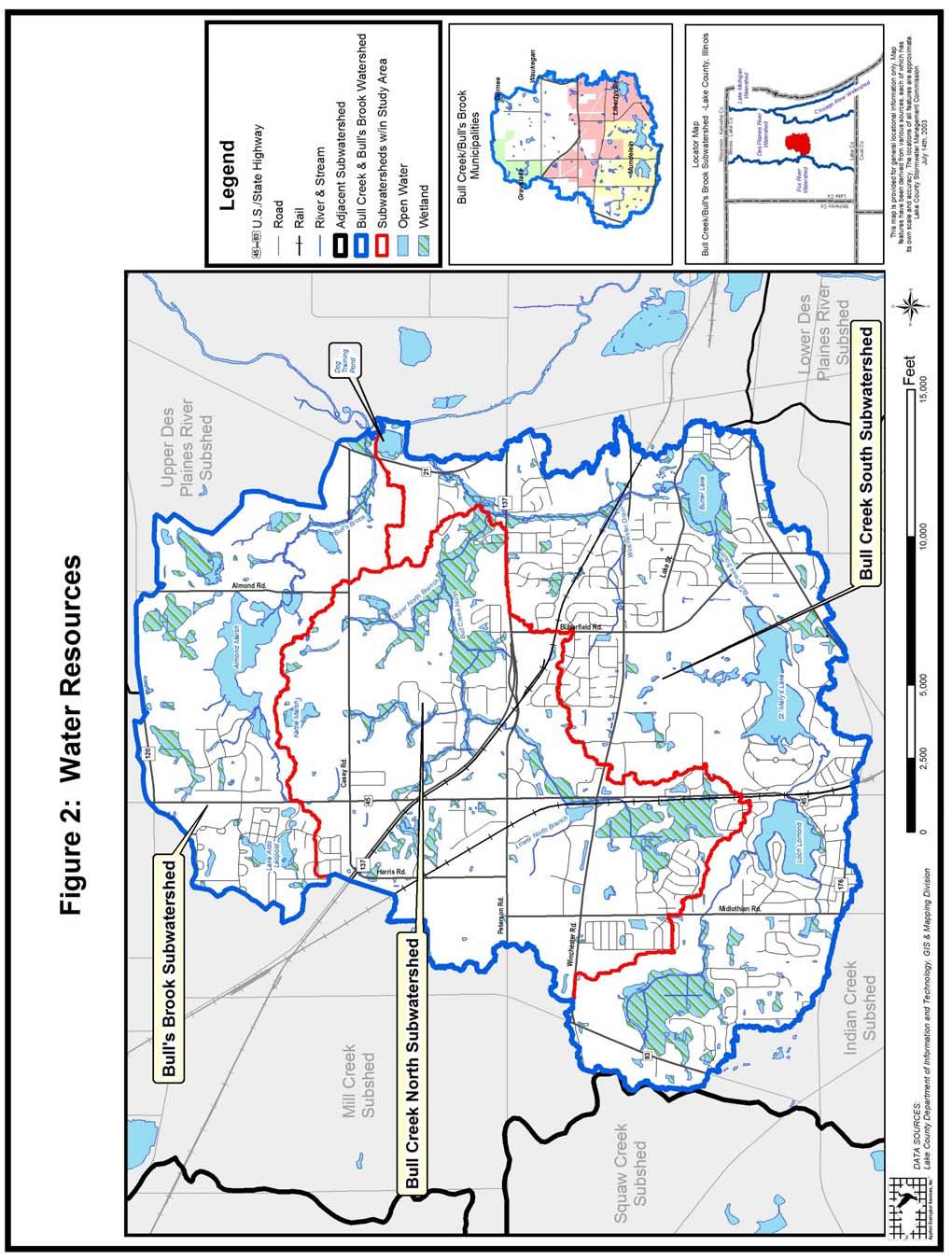
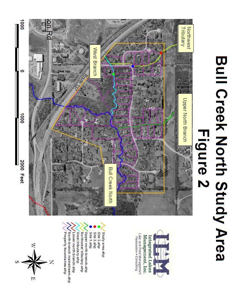
3 I. INTRODUCTION A: Purpose and goals In 2007 the Liberty Prairie Area Homeowners Association (LPAHA) received a Conservation 2000 Ecosystems Program Project Grant from the Illinois Department of Natural Resources to create a restoration, education, and outreach plan for the LPAHA section of Bull Creek. The grant was awarded due to serious flooding, erosion and neglect of the creek which has caused loss of habitat, soil and trees. The project is to design a plan to restore eroded streambanks and educate landowners regarding their responsibilities to maintain the stream and streambanks. The next step would be for the LPAHA to apply for various grants to implement the recommended erosion control procedures. Integrated Lakes Management (ILM) was contracted by the LPAHA to conduct a detailed physical survey of the Bull Creek channel, tributaries and floodplain within the Bull Creek neighborhood (approximately 7,850 feet). Goals of the project were to: 1. Provide a detailed survey of Bull Creek and its tributaries in the Bull Creek neighborhood including photos and documentation 2. Characterize and define major problems regarding erosion along the stream 3. Create a restoration plan with site specific solutions B: Background Bull Creek is located in central Lake County in northeast Illinois and is divided into two main tributaries, Bull Creek North Subwatershed and Bull Creek South Subwatershed (Figure 1). This report covers only the Bull Creek North section within the Bull Creek subdivision, which is located in unincorporated Libertyville Township, immediately north of IL Route 137 (Figure 2). Several studies have been performed on Bull Creek, with the latest report still in the draft stage ( Bull Creek/Bull s Brook Watershed-Based Plan by Applied Ecological Services, Inc, and the Lake County Stormwater Management Commission (September 2007 Draft 1 Revised)). Much of this brief background description for the Bull Creek subdivision was found in that report. The watershed for the section of Bull Creek North studied in this report encompasses an approximately 3.7 square miles (2356 acres), or about 2/3 of the entire Bull Creek North subwatershed). Much of the land use in the watershed is agricultural, although there is some industrial, commercial and residential areas according to the Bull Creek/Bull s Brook Watershed-Based Plan (September, 2007 Draft). According to the Year 2020 projected land use changes, much of the agricultural and open land within this watershed Integrated Lakes Management S:\P&P\Consulting\Watersheds\Bull Creek 2007\Report\Final report\report Rev2.doc 3
4
5


6 Locations of Mapped FEMA Floodplains in Lake County, Illinois LakeCounty Geographic Information System Lake County Department of Information and Technology 18 N County St Waukegan IL Map Printed on 7/21/2008 Parcels Zone X Zone X Yr Flood SFHA Yr Flood Zones A, AE and AH Floodway Municipalities Major Roads Railroads Major Water Parcels Disclaimer: Property boundaries indicated are provided as a courtesy for general locational purposes. Floodplain limits shown are approximate and should not be used to determine setbacks for structures or as a basis for purchasing property. A topographic survey is required to determine existing floodplain boundaries. This map is intended to be viewed and printed in color.

7 may become industrial, especially in the headwater sections of the watershed. In this report, the Bull Creek North Subwatershed has 25% impervious surface area, and is considered borderline impacted to non-supporting regarding stream habitat, water quality and biological communities. With development of more industrial areas in the headwater sections of the stream, the amount of impervious surface will increase, and the stream will likely degrade further. Four areas were studied by ILM within the Bull Creek Subdivision (Figure 2), these included: 1. Bull Creek North from Route 137 near Old Peterson Rd. to the east end of the Bull Creek subdivision east of Countryside Road. Length of 2,651 feet and a gradient of 56 ft/mi (or ft/ft). The stream is then blocked by a very large beaver dam located east of Countryside Road. Bull Creek North extends eastward out of the project area to meet with Bull Creek Main stem. 2. West Branch from Route 137 near Bull Creek Dr. until it joins Bull Creek North. Length 1,611 ft with a gradient of 72 ft/mi (or ft/ft). 3. Northwest Tributary between Leesley and Saint Andrews Dr. The study begins at the northern-most property within the subdivision. Length is 1,337 ft with a gradient of 39 ft/mi (or ft/ft). 4. Upper North Branch between Bob-O-Link Lane and Pinehurst Court. The study begins at the power lines. The creek length is 1,025 ft through the subdivision with a gradient of 51 ft/mi (or ft/ft). Stream length was measured from a 2006 aerial photograph with ArcView and stream gradient was determined from the 2 foot topographic maps available on Lake County Maps OnLine. According to the Stream Restoration Inventory Final Report, April 2005 produced by Northeastern Illinois Planning Commission, these stream sections are high gradient streams, which is typical for smaller watersheds. High gradient streams respond rapidly to increases in impervious surface and tend to be highly erodible. Such streams require reducing the stream energy with grade controls (rock riffles) and stabilizing the streambank with Bull Creek Dr. nondegradable materials (riprap) where roadways, homes or sewer lines are affected. The LPAHA has been very active in removing stream blockages with multiple workdays having occurred. However, they are finding that new blockages keep occurring after major storm events. The deep, narrow channel has been undermining trees and shrubs, causing the blockages. Blockages can alter the natural stream channel and cause localized flooding and downstream erosion. They also cause increased sedimentation upstream of the blockage Integrated Lakes Management S:\P&P\Consulting\Watersheds\Bull Creek 2007\Report\Final report\report Rev2.doc 7
 identifies several areas of flooding within the Bull Creek subdivision.")


8 that can negatively impact the habitat for fish and macroinvertebrates as the fine silt covers the natural gravel or cobble streambed. II. FLOODING ISSUES The Bull s Brook/Bull Creek draft report (Sept. 2007) identifies several areas of flooding within the Bull Creek subdivision. Two areas with local drainage problems were noted in this report, one within the West Branch and one in the Northwest Tributary. The West Branch drainage problem is due to localized flooding from a buried pipe. The Northwest Tributary may be due to inadequate culvert sizing or blockage. Two other areas of over bank flooding were noted in this report on Bull Creek North. These areas are due to low streambanks. Northwest Trib Leesley West Branch Exposed inlet at Leesley during low flow. Several areas of underground pipes were observed during the stream walk. One was located in the upper reach of the Northwest Tributary at Leesley, and the other was West Branch at Leesley Northwest Trib. at Leesley during high water in March at the West Branch west of Bull Creek Drive. During ILM s first stream walk in March, the yards were flooded since the pipes were full. Once the water receded we could see that the stream had eroded and exposed large sections of pipes. Blockage of the inlets for these pipes cause localized flooding. ILM recommends that these pipes be removed and a stream channel created. Integrated Lakes Management S:\P&P\Consulting\Watersheds\Bull Creek 2007\Report\Final report\report Rev2.doc 8

9 Within the Bull Creek subdivision the stream and tributaries are quite steep and runoff occurs quickly. The stream has cut a deep channel and flooding tends to be caused mainly by stream or culvert blockages. Most of the homes tend to be well outside of the floodplain; however there is one that is very close to the creek at Valley Court. The homeowner said that he has lived there for about 30 years and although the stream has reached the second wall, it flows Bull Creek N. at Valley Ct. over the road before it reaches his home. Several sheds and garages are fairly close to the creek and may be within the floodplain. Several homeowners have expressed concern that the creek appears to have more water flow now than it did historically. Most notably, the stream flow appears higher since the development of the Libertyville Sports Complex, located on the West Branch, on the south side of Route 137, immediately upstream of the Bull Creek Subdivision. ILM reviewed the Lake County Stormwater Management Watershed Development Permit for this site and according to the hydraulic modeling performed for this site, during high flows, there is slightly less water leaving the site than there was prior to development. Bob Gardiner from SMC explained that this frequently happens when detention basins are created to hold back the flow. So the flow rate discharged off-site from the Sports Complex is at a steadier rate for a longer period than before development. This makes the stream have a more steady flow during low flow periods, but not have a higher flow after storm events. Bob also said that although computer models approximate the flow rates, there is a possibility for a site to discharge more flow than originally planned, but he felt that the difference is usually small. III. STREAMBANK RESTORATION OPTIONS A: Establishing a Conservation Easement Patty Werner from the Lake County Stormwater Management had recommended establishing a conservation easement for the Bull Creek corridor. The easement should involve the creek channel, banks, and buffer zone (~ 30 ft). This would be beneficial in applying for grant funding and allow the unit to be maintained without requiring individual landowner permission. A copy of the Army Corps typical Grant of Conservation Easement is in the appendix of this report. This is a legal issue that will need to be discussed with a lawyer and the LPAHA. B: Permitting Generally streambank restoration projects will involve permitting from various agencies, depending on the methods proposed. This can add significant costs and delays to the project and should be taken into consideration. Generally anything that disturbs the soil, Integrated Lakes Management S:\P&P\Consulting\Watersheds\Bull Creek 2007\Report\Final report\report Rev2.doc 9
10 other than installing plant plugs, will require permits. Usually installing plant plugs, laying matting without regrading, and clearing vegetation does not require Army Corps or Watershed Development permit (SMC), although other local permits may still be needed. Installing brush fascines usually do not require permits, at least if they are above baseflow conditions. Regrading of the shoreline, installation of riprap or seawalls will require an Army Corps permit. Typically Army Corps permits will require a wetland delineation, a detailed site plan, and consultation for threatened and endangered species. If riffles are to be installed then H & H (hydrology and hydraulics) modeling will be needed. Army Corps review and permit issuance will require at a minimum of 6 months, if not a year or more if modifications to the original permit application are needed. The Illinois Department of Natural Resources (IDNR)/Office of Water Resources (OWR) will also receive a copy of the Army Corps permit and may also issue a permit. There are usually no permit fees required with Army Corps permits. A Watershed Development permit will likely be required for earth change approvals, wetland impacts, and/or development within a floodplain. Permit review fees are required by SMC and are based on the size of the project. A general rule-of-thumb is to allow an extra 6 months to 1 year for permit application review and an increase of 10% over the cost of the project to account for permitting fees, but this can vary depending on the type of project. C: Methods 1: Debris blockages: Some woody debris in a stream provides a healthy environment, but how much is too much? The American Fisheries Society published a pamphlet entitled Stream obstruction removal guidelines, 1983, which is included in the appendix of this report. Stream blockages become a problem when they obstruct the flow and cause flooding and / or streambank erosion. Generally, unless the entire stream is obstructed, the blockage should remain. Sometimes the logs can be moved and attached to the side of the stream, where it is less likely to obstruct the flow. Logs should be keyed into the bank to prevent them from being dislodged during Debris blockage at Country the next flood event. The use of duckbill anchors and 1/8 inch airline cable should help with attaching the logs to the bank. Isolated accumulations of gravel and rock should remain, since these provide good riffle habitat. Dead trees that are leaning across the stream, and are likely to fall in the near future should be cut. Root wads should remain if they are not totally obstructing the creek or can be attached to the bank. Integrated Lakes Management S:\P&P\Consulting\Watersheds\Bull Creek 2007\Report\Final report\report Rev2.doc 10


11 The LPAHA should continue to perform periodic stream cleanups and remove debris blockages. However, it is recommended that the American Fisheries Society document be reviewed prior to determining which blockages to remove. Larger water volumes are likely to cause more problems when encountering a stream blockage than the smaller volumes found in headwater areas, so usually starting from the furthest downstream point and working upstream is a general rule of thumb. Also clearing debris that may be close to buildings and other structures is another high priority. 2: Brush clearing: One of the main problems with many streams is overgrowth of the riparian zone, usually with non-native species such as buckthorn and honeysuckle. These species can become so dense that they shade the ground and prevent grasses and forbs from growing. Often the one of the few herbaceous plants that grow well under Cleared buckthorn at 18571Bull Creek Dr... Buckthorn jungle view facing downstream from Bull Creek Dr. these conditions is garlic mustard, another invasive species. Although buckthorn offers some protection of the soil from the forces of rain drops during the growing season, the soil is very exposed during the winter when the shrubs are bare. Buckthorn can be cleared and provide immediate results, however maintenance herbiciding is needed to prevent the cut stumps from resprouting and to kill young seedlings. This needs to be done annually for a number of years, depending on the seed bank. ILM observed a tremendous amount of buckthorn within the Bull Creek Subdivision. A few homeowners had cut the majority of the plants, but seedlings were observed that need to be herbicided. While there are herbicides available for public use, there are no herbicides available to the public for use within a stream bed. Products like Roundup can be used in upland areas and only on the individual s property. Before and after views of a shoreline restoration project using vegetation. Photo courtesy of SER. Integrated Lakes Management S:\P&P\Consulting\Watersheds\Bull Creek 2007\Report\Final report\report Rev2.doc 11


12 Another concern is shading of the streambanks. For some homeowners that have cleared their yards, often the opposite shore was not cleared and caused shading of most of the streambank. Ideally both sides of the streambank should be cleared to allow adequate sunlight. The width of this clearing should be as wide as possible, but at least 30 feet from the top of the bank would be needed in order for prairie grasses and forbs to become established. Streams do need some shading to keep the water cooler and to provide leaf detritus and habitat. Only cutting of the non-native species is recommended. Seeding of the bare soil with native grasses and forbs is then needed. Seeding over the winter allows freeze-thaw to move the seed down into the soil. 3: Vegetative/Soft: Planting a shoreline and/or seeding are an easy and cost effective way to protect a shoreline. Trees, shrubs and grasses all have vast root systems and can bind to the soil and prevent erosion. These and other herbaceous plants can help protect the soil from raindrop impact and runoff from upland areas. Aquatic emergent Examples of using live stakes (left, courtesy of Wisconsin Department of Natural Resources) and fascines (right, courtesy of Audra Luscher) to stabilize the shore. Use of a coir log along a shoreline with plantings. Shown with a graded bank, could also be used along a bank showing undercut erosion. Photo courtesy of Audra Luscher. plants can help stabilize the bottom sediments and provide a buffer for moving water and wave action. This method can also include using organic materials that will degrade over time while building up shoreline protection such as coir log installation. The use of brush fascines and live stakes can also protect the shoreline. Depending on how the various agencies interpret the regulations, coir logs may be considered as fill within the floodplain while generally brush fascines are not, since the material is already present. Fill material usually requires an Army Corps permit. Integrated Lakes Management S:\P&P\Consulting\Watersheds\Bull Creek 2007\Report\Final report\report Rev2.doc 12


13 4: Structural: This method includes constructing a barrier between the water and shoreline. The placement of rocks of various sizes (rip-rap) is the preferred and most common method. Another method is constructing a seawall. These methods are more expensive and are less aesthetically pleasing than a vegetated shoreline. However, constructing these types of hard structures can cause erosion elsewhere. Hard structures are very good at diverting energy and can cause erosion to unprotected shorelines. These methods also require more heavy machinery and land impact. These methods will also require an Army Corps permit and a Watershed Development permit. Rip-rap along a stream. Photo courtesy of Oakland County, Michigan. Timber seawall. Vinyl, steel and concrete could also be used. Photo courtesy of RAM of CNY, Inc. 5: Manipulative: This method is most commonly used in streams. It includes removing obstructions, grading the shoreline and in special circumstances rerouting the stream channel. Obstructions can be removed it they are causing blockages, some overhanging vegetation is good for habitat. While fascines and coir logs can be placed along a steep or undercut bank, the banks can also be graded. They can create a gentler slope and planted and seeded to prevent further erosion. This option may not be available if structures are close to the stream. Rerouting the stream channel is an option when the stream was previously altered to accommodate agriculture or other development. The stream in this survey has not been altered and does not need modification. Springbrook Creek restoration 11/07 Rip rap with plantings along the shore. Photo courtesy of Sotir & Associates, Inc. 6: Hybrid: This method involves using the above methods in concert with another. The hybrid method is usually the most expensive because more than one option is Integrated Lakes Management S:\P&P\Consulting\Watersheds\Bull Creek 2007\Report\Final report\report Rev2.doc 13
14 utilized. Some examples are installing rip-rap and planting or seeding the area, or grading the shoreline before planting or seeding. D: Cost Chart Method Materials Labor Comments Brush clearing (BC) $300/acre $3,000/acre Higher if need to purchase chainsaws or haul material away from site. Cost based on burning brush piles on-site. Herbiciding (H) $70/acre $560/acre Need herbicide license from IL Dept. of Ag. Seeding (S) $500/acre $280/acre Costs depend on seed mix used Plug plants (P) $1.75/plug $2/plug Plant plugs on 12 inch centers. Costs double if fencing is to be used to protect plants Matting (M) $45- $95/roll $70- $210/roll Straw matting (upland) $40/roll (100 ft x 8 ft), coconut matting (wet areas) $90/roll +$5/roll staples. Labor costs vary. (100 x 8 ft) $5/bundle $70/bundle Use onsite materials, oak stakes and nonbiodegradable twine. Brush fascines (BF) Coir log (CL) $9/lf $14/lf Material cost includes stakes and rope. Riprap (RR) $30-$45/lf Costs vary depending on the types of materials used and access to the shoreline Grading (G) NA $50/lf Costs can vary widely Seawalls (SW) $65-$100/lf Included in price Costs vary depending on steel vs. vinyl and access to the shoreline IV. FIELD EVALUATION One of the main objectives of this project was to evaluate each property along Bull Creek North and its tributaries within the Bull Creek Subdivision for erosion. The characteristics of each property as well as their neighbor s shoreline were taken into account to determine the best restoration method. A chart with estimated labor and materials is included on the next page. Costs may vary depending on the contractor, current site conditions, and exact methods chosen for restoration. The Erosion Control Cost Chart is meant to be an estimate for planning purposes only. One of the more costly items is planting plant plugs. The number of plants, the size, and the species chosen will greatly affect costs. The area that is to be seeded or planted determines the plants that will be used, especially in terms of the amount of shade present and the wetness of the soil. In some areas wetland species are recommended, but since plants will only grow in areas with slow moving water, most of the recommended plants are deep-rooted, upland grasses and forbs. Grasses have many small roots better capable of holding the soil where flowering plants would have a few large tuberous roots. From the figure below, notice that the grasses have more extensive roots than the flowering plants. Integrated Lakes Management S:\P&P\Consulting\Watersheds\Bull Creek 2007\Report\Final report\report Rev2.doc 14
, buckthorn (Rhamnus spp.), and multiflora rose (Rosa multiflora).")
15 Root systems of prairie plants. Figure courtesy of Wild Ones. A majority of the trees and shrubs along the stream are non-native invasive species including honeysuckle (Lonicera tatarica), buckthorn (Rhamnus spp.), and multiflora rose (Rosa multiflora). Box elder (Acer negundo) is one of the dominant tree species and it is considered invasive even though it is a native species. It would be beneficial to remove these trees and shrubs from the riparian zone. Replacing these invasives with non-invasive native species would increase the biodiversity of the banks. An ecosystem with a greater variety of quality organisms is considered healthier than one whose biodiversity is low. Invasive species tend to be able to adapt quickly to an environment and reproduce rapidly. They are able to outcompete native species and can eventually take over an area crowding out more diverse and beneficial native plant communities. This happens most aggressively in areas that have disturbed soil. Although individual plant species could be chosen for each site, ILM has found several seed mixes that are reasonably priced and the species have good survivorship. It is highly recommended that most of the species planted be native grass mixtures mixed with forbs. ILM recommends two IDOT (Illinois Department of Transportation) mixtures for upland grasses. IDOT Class 4 (Native Grass Mixture), and IDOT Class 4A (Low Profile Native Grasses). However, these mixtures include some perennial ryegrass (Lolium perenne), a non-native species that is very persistent. It is recommended that this be replaced with spring oats, which are an annual species. ILM frequently adds extra switchgrass (Panicum virgatum) to the mixture, since this grows very well on disturbed soil. For low areas close to the creek we recommend IDOT Class 4B (Wetland Grass and Sedge Mixture). Forbs that should be added for upland areas include IDOT Class 5A (Large Flower Native Forb Mixture) and IDOT Class 5B Integrated Lakes Management S:\P&P\Consulting\Watersheds\Bull Creek 2007\Report\Final report\report Rev2.doc 15
16 (Wetland Forb Mixture) close to the creek. A detailed listing of the species included in these mixes is included in the appendix. A listing of suggested plant plugs is also included in the appendix. The Illinois Urban Manual should be consulted for seeding and planting as well as for matting installation. A copy of SMC s Streambank and Shoreline Protection Manual is also included in the appendix. This document shows schematics of various erosion control techniques. Some of the homeowners have expressed concern over removing buckthorn since it acts as a good screen for privacy. Buckthorn becomes extremely thick and shades the soil and prevents almost all of the herbaceous undergrowth. ILM recommends that red osier dogwood (Cornus stolonifera) and other native shrubs be planted in areas near the stream and in sunny or partially shady areas as an alternative. Integrated Lakes Management S:\P&P\Consulting\Watersheds\Bull Creek 2007\Report\Final report\report Rev2.doc 16
17 A: Property Chart Bull Creek Subdivision - Erosion Control Cost Chart Linear ft Acreage* Methods Estimated Estimated Estimated Material Labor Total Costs Costs Northwest Tributary N Leesley Ct Daylight pipe NA NA NA N Leesley Ct. 350 Daylight pipe NA NA NA N Leesley Ct BC/H/S/BF/P $966 $2,388 $3, N Leesley Ct BC/H/S $191 $701 $ N Leesley Ct H/C/S/P $1,552 $3,741 $5, N Leesley Ct H/C/S/P $1,331 $3,527 $4, Saint Andrews Dr BC/H/S $72 $264 $ Saint Andrews Dr H/S $106 $130 $ Saint Andrews Dr H/S $106 $130 $236 West Branch N Leesley Ct. 100 Daylight pipe NA NA NA N Leesley Ct BC/H/S $180 $661 $ N. Bull Creek Dr BC/H/S $899 $3,306 $4, Bull Creek Dr BC/H/S $144 $529 $ Bull Creek Dr BC/H/S $108 $397 $ Bull Creek Dr BC/H/S $108 $397 $ Bull Creek Dr SW or RR** NA NA NA Bull Creek Dr BC/H/S $126 $463 $ Bull Creek Dr H/S $71 $87 $ Bull Creek Dr BC/H/S $162 $595 $ Bull Creek Dr BC/H/S $119 $322 $ Bull Creek Dr BC/H/S $144 $529 $673 Bull Creek North Bull Creek Dr G/RR** NA NA NA Bull Creek Dr BC/H/S/BF/P $1,117 $2,729 $3, Bull Creek Dr BC/H/S $144 $529 $ Bull Creek Dr BC/H/S $144 $529 $ Bull Creek Dr BC/H/S/BF/P $1,117 $2,729 $3, Bull Creek Dr BC/H/S/BF/P $698 $1,706 $2, Bull Creek Dr BC/H/S/BF/P $447 $1,092 $1, Countryside Dr BC/H/S/BF/P $1,676 $4,093 $5, Countryside Dr H/S/P/MC/MS $2,954 $3,731 $6, Bull Creek Dr H/S/MS $233 $537 $ Bull Creek Dr H/S $94 $116 $ Countryside Dr BC/H/S $557 $2,050 $2, Valley Ct BC/H/S $234 $860 $1, Valley Ct BC/H/S $234 $860 $1, Valley Ct G/RR** NA NA NA Valley Ct BC/H/S/BF/P/MC $3,600 $12,738 $16, Country Ct BC/H/S/MS $734 $2,901 $3, Country Ct H/S/MS $543 $1,252 $1, Country Ct H/S/MS $620 $1,431 $2, Country Ct H/S/MS $155 $358 $ W Old Peterson Rd BC/H/S $180 $661 $ Route BC/H/S $1,294 $4,760 $6,055 Upper North Branch W. Bull Creek Dr BC/H/S/BF/P/MC/MS $1,584 $3,794 $5, W. Bull Creek Dr BC/H/S/BF/P/MS $1,650 $4,161 $5, Pinehurst Ct BC/H/S/BF/P/MS $833 $2,081 $2, Pinehurst Ct BC/H/S/BF/P/MS $1,155 $2,913 $4, Pinehurst Ct BC/H/S/BF/P/MS $600 $1,498 $2, W. Bull Creek Dr BC/H/S/BF/P/MC/MS $1,584 $3,794 $5, W. Bull Creek Dr BC/H/S/BF/P/MS $1,333 $3,329 $4, Bob O Link Ln BC/H/S/BF/P/MS $990 $2,497 $3, Bob O Link Ln BC/H/S/BF/P/MS $1,000 $2,497 $3, Bob O Link Ln BC/H/S/BF/P/MC/MS $1,260 $3,018 $4,278 * based on 30 ft wide buffer Method Material Labor Brush clearing BC $300 /acre $3,000 /acre Herbicide H $70 /acre $560 /acre Seeding S $500 /acre $280 /acre *Prices of these materials would be Planting P $2 /plug $2 /plug determined by contrator doing the work. Matting - coconut MC $95 /roll $210 /roll Matting - straw MS $45 /roll $150 /roll ** Methods chosen based on proximity Brush fascines BF $5 /bundle $70 /bundle of structures or steepness of bank and Cutting C $70 hr amount of erosion present Riprap RR NA* NA See text for detail. Grading G NA* NA Seawall SW NA* NA
 at 18372 Valley Court said that he had lived there about 30 years and said that the low flows are much higher flows than they had been historically.")

18 B: Site Specific Information Bull Creek North West of Countryside Drive is where the streambank erosion is most severe. The homeowner (Jim Schuler) at Valley Court said that he had lived there about 30 years and said that the low flows are much higher flows than they had been historically. His property along the creek is quite extensive and is the only home close enough to the creek to be of concern during flood events, so he has had to install some erosion control measures. A wooden seawall was installed many years ago to help protect the home. He said that during floods, Valley Ct. the water gets up to the second seawall. The seawall appears to be in good shape and the homeowner has been maintaining it as needed. A waterfall was also installed since one had formed naturally from downed trees. The waterfall can be seen from Countryside Drive and is a prominent feature of the creek. Many fish congregate both upstream and downstream from this drop. Although the Schuler property is not actively eroding, we would still Valley Ct. recommend a shoreline buffer of 30 feet to reduce erosion and to filter nutrients from entering the creek. Several openings for access areas should be provided. Integrated Lakes Management S:\P&P\Consulting\Watersheds\Bull Creek 2007\Report\Final report\report Rev2.doc 18


19 The land on the north side of Bull Creek is much higher in Bull Crk. Dr. elevation in this area. Some of these areas are eroding faster than others and this mostly has to do with the amount of vegetation present. At Bull Creek Drive, the shoreline is about 4-6 feet above the south shoreline. Two very large trees blew down and tore up the shoreline. This has created a vertical wall that is too steep to plant. However, several options are possible. One is to remove the dead trees and the root ball, then regrade the streambank as needed. This is the expensive option and re-grading of the shoreline will require an Army Corps permit. Since these trees are providing wildlife habitat and are not infringing on the landscaped part of the yard, the homeowner could leave them and plant riverbank grape or some other vine in the vertical streambank. This may provide some erosion control with the roots holding the soil in place. Another potential low cost solution would be installing willow posts in this area, or installing brush fascines and planting around them. We do not recommend matting this area, since the existing tree roots provide some stabilization. Within a few years this area will likely be covered with plants and will not be so Bull Crk. Dr. obvious. Buckthorn control is also recommended here with native grasses planted in the upland areas. The property at Bull Creek Drive also contains some bare slopes and a riffle Valley Ct.. According to the neighbor, Jim Schuler, historically the creek did not split and form an island (right), which is what is now present when the stream level is up. All of the flow had gone around a 90 degree turn, hitting the bank (above). We recommend that the buckthorn is cut and herbicided and that native grasses be Integrated Lakes Management S:\P&P\Consulting\Watersheds\Bull Creek 2007\Report\Final report\report Rev2.doc 19


20 planted in the upland areas. Brush fascines are recommended at the bare slope at this address. Some additional rock or logs are needed at the toe of the slope to reduce erosion during low flows. A section of Valley Court and also at Bull Creek Drive had armored shorelines with rock. These two sections had mowed lawn up to the rocks. We recommend that mowed lawn be kept to a minimum at the streambank and that a 30 ft native buffer be planted at these locations Valley Ct Bull Crk. Dr. At Valley Court the streambank is about 3 feet high and a 30 foot native buffer is recommended by removing buckthorn and seeding with native vegetation. Typically a 30-foot buffer is recommended by agencies. Clearing and planting is needed at many locations along the creek. The most severe erosion observed within the Bull Creek subdivision occurs at Valley Ct. This area has at least a 6+ foot vertical drop and has trees that are about to fall. The reason that this area is eroding so severely has to do with several factors. A small riffle above this area is pushing water against it, so that even under low flows, some minor erosion is occurring. Also this site is immediately downstream of where the upper north branch enters Bull Creek, increasing the discharge. The soil is very crumbly and the tree roots are not long enough to reach down to the bottom of the bank. This is undermining the trees. Above this Valley Ct. streambank are dense buckthorn and other woody vegetation. Methods to repair this section can vary dramatically. Regrading the streambank would be the traditional method, but this involves permitting and can be quite expensive. Once it is regraded then riprap would be placed from the low water to the high water level and native plantings installed above the riprap. Cost for this would probably be several Integrated Lakes Management S:\P&P\Consulting\Watersheds\Bull Creek 2007\Report\Final report\report Rev2.doc 20

21 hundred dollars per linear foot. If the homeowners association wants to try to tackle this area themselves, then cutting down the trees that are about to fall would be the first task. This would probably be easier than waiting for them to fall into the creek. Some of the cut trees could be installed as brush fascines at the toe of the slope. It is very important to key the brush fascines into the slope with stakes and duckbill or deadman anchors to prevent them from moving downstream and causing blockages. Some trial and error will need to be done since the soil is fairly loose. There is no guarantee that this method will work, but it may be worth a try since the cost is minimal. The goal is to direct the flow away from the base of the slope to reduce erosion. The stream is doing this naturally with debris buildup at the base of the slope. Brush fascines should also be installed part way up the slope to help trap soil and allow some plants to grow. The upper part of the slope will still collapse over time, but if we can get native plants at the top of the bank, then this collapse should be minimal. Other recommendations for this section include rearranging the upstream riffle so that low flows go straight downstream and not into the bank. Probably just a few rocks need to be rearranged to redirect the low flows. Some additional rock at the toe of the slope would also help reduce erosion. Installing new rock into the stream would require permits, but rearranging small rocks already in the stream may not (but should be checked). One of the problems of this section is that the gradient is pretty steep. This section could be developed into more riffles and pools by installing larger boulders to create better defined riffles. However, this will also change the hydraulics in this area and would require an Army Corps permit and a hydraulic analysis by an engineer. As you can see there are a variety of ways to work with this section depending on volunteer commitment and on costs. The volunteer method may not completely stop erosion, but it should offer significant reductions and will allow the bank to stabilize by itself. Since no structures occur nearby, the association may want to try the volunteer method and see how it works first. ILM staff would be available on a time and materials basis to assist the volunteers in this effort. Stump should be cut back a few feet Several debris blockages were observed in this area, both before and after removal. This will continue to be a problem due to the steep banks and heavy tree growth. Since this area is very erosion prone it important to periodically remove the debris jams. The debris should be removed far enough above the stream so that it does not block the flow during high water events. Integrated Lakes Management S:\P&P\Consulting\Watersheds\Bull Creek 2007\Report\Final report\report Rev2.doc 21


22 Severe erosion was observed at Bull Creek Drive, where a vertical bank occurs at a pool below a log jam. Part of this log jam was removed recently. Although this slope is not as high as at Valley Ct, the water depth in the pool is several feet deep, making this repair a little different. Traditionally the slope Bull Crk. Dr. would be regraded and rip rap installed up to the high water mark. The volunteer method would be to cut the overhanging trees, install logs and/or rock along the base and build up the material to about 2-3 feet above baseflow conditions. Brush fascines should be installed into the slope. The extent of this repair is about 50 feet from one riffle to the next. The reason that this area is eroding is that the riffle above directs water flow against this slope during baseflow conditions, so the erosion is slow, but continual. High flow events may also be contributing to erosion in this area. At the junction of the west branch to Bull Creek North at Country Court, the site erosion was less than one would anticipate for a stream confluence. This property had quite a few downed trees across the Country Ct. stream and lawn debris at the top of the slope by the creek. These debris jams should be removed as soon as possible. The large willow is not affecting the stream at very low water, but will at higher flows. This property also had large areas where mowed lawn occurred to the top of the stream bank. We recommend that these debris jams be Country Ct Country Ct. Integrated Lakes Management S:\P&P\Consulting\Watersheds\Bull Creek 2007\Report\Final report\report Rev2.doc 22


23 18510 Country Ct. removed, and that a buffer zone of at least feet, when possible, be installed with native vegetation. Buckthorn should also be removed. Some broken concrete was also installed at the south end of this property Country Ct. The section along Bull Creek from Route 137 to the junction with the west branch including properties at 18518, 18523, and Country Court all had mowed lawn to the top of the streambank. The stream is much smaller here and many small debris jams should be removed as well as having a buffer zone installed. Erosion in this area is minor. Trash removal and rock at the bottom of pipes is also recommended, such as at Country Ct. Several logs were across the creek at Old Peterson Road by the Route 137 culvert. This property had a buffer that needed some maintenance Country Ct Country Ct Old Peterson Rd. Integrated Lakes Management S:\P&P\Consulting\Watersheds\Bull Creek 2007\Report\Final report\report Rev2.doc 23
 is a farmfield with a riparian buffer zone around the creek. The north side is homes with little to no buffer zone.")
 and plug planted with native vegetation.")

24 East of Countryside Drive, the streambanks are not as steep. Mostly 2-3 foot banks. The south side of the property (30805 Countryside Drive) is a farmfield with a riparian buffer zone around the creek. The north side is homes with little to no buffer zone. Some bare areas and burn piles occur next to the creek. At Countryside Drive, a large area of bare soil occurs immediately downstream from the road. This area should be matted with erosion control matting (North American Green C125 or equivalent) and plug planted with native vegetation. In other areas of this property lawn grasses grow up to the shoreline. Lawn grasses have very shallow roots and do not provide adequate Countryside Dr. erosion control. Some access areas with mowed lawn can be provided, but we recommend that the majority of the shoreline be matted and planted as above. It is also recommended that the grass be herbicided prior to seeding and matting. Herbiciding allows the prairie seed to penetrate the sod layer. Across the creek at Countryside Dr. in the farmfield, there is some erosion present but it is fairly minor, and the site is heavily wooded. Removal of buckthorn and planting of native grasses would be recommended for this site Countryside Dr Countryside Dr. The homes at and Bull Creek Drive have slight buffer zones but these should be widened to a minimum of 10 feet and planted with native vegetation. Since a very small buffer exists, only seeding with prairie plants is needed after the lawn grass is herbicided. Integrated Lakes Management S:\P&P\Consulting\Watersheds\Bull Creek 2007\Report\Final report\report Rev2.doc 24


25 TRIBUTARIES The Upper North Branch of Bull Creek North exits a detention basin at the north end of Bob-O-Link Lane within the Woodhollow subdivision. The pond N. Bob-O-Link shoreline is mostly armored with rock and is used for recreation. Small boats and piers were observed. South of this subdivision the creek runs through an undeveloped section and underneath some high tension power lines before entering the Bull Creek subdivision between Pinehurst Court and Bob-O-Link Lane. Within the Bull Creek subdivision the Upper North Branch has been channelized with steep slopes and forms more of a ditch than a creek. This tributary frequently dries up, which was how it was observed on our September 24 th visit. The tributary is heavily overgrown with trees and shrubs, most of which are Pinehurst Ct. facing south buckthorn, honeysuckles and willows. Many of the homeowners have fenced off their yards from the creek so regrading this section would be difficult. The homeowner at N. Bull Creek Drive has installed rock at the toe of the slope to help reduce erosion N. Bull Creek Dr. rocks Erosion control of the entire Upper North Branch should involve removing brush and exotic trees so that grasses and other native vegetation can become established on the slopes. The heavy tree growth shades the ground and prevents grasses from stabilizing the shore. Brush fascines should be installed on the steeper slopes to help reduce erosion. Straw matting can be used on the slopes to help hold the seed in place and to act as a mulch for plug plants. Integrated Lakes Management S:\P&P\Consulting\Watersheds\Bull Creek 2007\Report\Final report\report Rev2.doc 25


26 However, in areas of more severe erosion, such as at Bob-O-Link, stronger matting, such as North American Green C-125 or equivalent should be used along with plug planting. A few of the Bob-O-Link homes on Bob-O-Link have cut some of the vegetation, but the neighboring properties on the west side shade the slopes and prevent other vegetation from growing. Both sides of the creek need to be cleared of invasive plants in order to promote native plant growth. A section of the Upper North Branch, at W. Bull Creek Drive, had a grant application submitted to the Lake County Stormwater Management Commission Watershed Management Board for erosion control involving matting, planting and brush fascines. The Northwest Tributary was also investigated between Saint Andrews Drive and Leesley Court. This tributary begins near Route 137 and traverses an Leesley Ct. undeveloped area prior to entering the Bull Creek subdivision. As it enters the subdivision at Leesley Ct. the stream enters an underground pipe that extended only for two properties. It appears to have extended further at one time since there are exposed drain tiles in the creek at Saint Andrews Dr. flow When the ILM crew initially direction investigated this tributary in March 2007, they found the stream running above ground since the underground pipe was flooded. One area below the pipe showed significant erosion as the tributary made a sharp bend. This property is located at Leesley Ct. and it is recommended that some brush fascines be installed and the exotic shrubs removed and native plants installed Leesley Ct. Flooded yard March 07 The Homeowner at Saint Andrews Dr. built a timber seawall to control erosion in this Integrated Lakes Management S:\P&P\Consulting\Watersheds\Bull Creek 2007\Report\Final report\report Rev2.doc 26


27 area. More exposed pipes were also observed at this property. It is recommended that the pipe for this tributary be removed since it is only functional during low flow events. The remaining exposed pipes should also be removed since they have become stream debris Leesley Ct St. Andrews Dr St. Andrews Dr St. Andrews Dr. Most of the Northwest Tributary north of Bull Creek Drive, only needs some brush clearing, mostly on the western side of the creek and seeding of native vegetation. The eastern portion of the tributary at Saint Andrews Dr. appears to be in good shape, although the native buffer zone could be a bit wider. The cattails at and Leesley slow down the flow and help trap sediment and help prevent erosion. However, they have formed a monoculture. The cattails should be replaced with non-invasive species such as bulrushes, water plantain, arrowhead, etc. to provide more diversity. Cattails are difficult to remove once they have become established and would take multiple herbicide treatments and maintenance of the new plants Leesley Integrated Lakes Management S:\P&P\Consulting\Watersheds\Bull Creek 2007\Report\Final report\report Rev2.doc 27


28 The Northwest tributary joins the West Branch of Bull Creek North at Leesley. The West Branch of Bull Creek North enters the Bull Creek subdivision at Route 137 at Rt Leesley Leesley. A small debris jam occurs near the Rt. 137 culvert. The creek travels about a hundred feet before entering an underground pipe. This pipe is frequently blocked and this area then floods and flows above ground across the yard at Leesley. When the creek flows on the surface the homeowner s yard is Leesley Leesley split in half and the creek must be crossed to access the remaining portion of the yard for mowing. It is recommended that this pipe be daylighted (removed) and a stream channel created and planted with native vegetation. This will help reduce water velocity downstream. However, if the homeowner is unwilling to daylight the pipe then a larger pipe may need to be installed to prevent overland flow. A three foot drop occurs where the above ground flow has eroded and exposed the pipe near Bull Creek Drive. Three culverts draining the Northwest Tributary and the West Branch occur very close together immediately west of N. Bull Creek Drive. Rip rap is typically the best method to control erosion around culverts. Integrated Lakes Management S:\P&P\Consulting\Watersheds\Bull Creek 2007\Report\Final report\report Rev2.doc 28
. All of these areas are heavily overgrown with buckthorn, which shades the soil and prevents soil stabilizing grasses to grow.")


29 On the east side of N. Bull Creek Drive is a heavily forested area along the road and encompassing several lots (30729 N. Bull Creek Dr., W. Bull Creek Dr., and 18698, 18680, & W. Capri Ct.). All of these areas are heavily overgrown with buckthorn, which shades the soil and prevents soil stabilizing grasses to grow. It is recommended that the buckthorn and other exotics be cut and that native grasses be installed. Buckthorn jungle. View from N. Bull Creek Dr. facing east N. Bull Creek Dr. The creek in this area has a 3 foot vertical bank, which becomes a 2 foot bank at W. Bull Creek Dr. and at W. Capri Ct. At a large tree blew down and the tributary is flowing underneath the root mass. The roots are providing some shoreline stability at this time, but the blockage should be removed W. Bull Creek Dr W. Bull Creek Dr. Old timbers At W. Bull Creek Drive a large building occurs near the stream and some major erosion is occurring near this structure. It appears that very old timbers are present in the streambank, providing some stabilization. However, this bank is still eroding and needs additional protection for the 5 foot bank. A seawall or rip rap may be needed here to protect the structure. The opposite shoreline is heavily wooded and should be thinned out by removing invasive species at N. Bull Creek Drive. This vacant property has shaded the shoreline of the northern properties along W. Bull Creek Drive, preventing native grasses from becoming established in areas where the buckthorn has been cleared. Integrated Lakes Management S:\P&P\Consulting\Watersheds\Bull Creek 2007\Report\Final report\report Rev2.doc 29


30 At W. Bull Creek Dr. an old bridge crosses the creek. The bridge is heavily overgrown with vegetation and is no longer usable. Clearing of mature buckthorn has occurred at this residence; however, the seed bank was full of buckthorn seeds and many W. Bull Creek Dr W. Bull Creek Dr. new seedlings were observed. These need to be herbicided as soon as possible or the clearing will have been for naught. Clearing of trees within the creek is also needed at this residence W. Bull Creek Dr N. Bull Creek Dr W. Bull Creek Dr. At W. Bull Creek Drive the yard has many young buckthorn shrubs and the stream is more shaded. This shading is allowing more soil to be exposed and more erosion, especially on the south shoreline at N. Bull Creek Drive. The buckthorn shrubs should be cut and herbicided. The shoreline at W. Bull Creek Dr. has steeper banks with about a 3 foot bank. Some pines and other trees are shading the shoreline. Although some Integrated Lakes Management S:\P&P\Consulting\Watersheds\Bull Creek 2007\Report\Final report\report Rev2.doc 30


31 exotics have been cut, others such as honeysuckle still remain. Planting of the shoreline with native grasses is recommended. Clearing of the opposite shoreline of invasive species at N. Bull Creek Dr. is also recommended to allow more sunlight at the soil surface, which will allow more herbaceous plants to grow. At W. Bull Creek Drive there is a fair amount of debris near the stream as well as log jams in the stream. This site also has exotic vegetation and a large playhouse. The W. Bull Creek Dr W. Bull Creek Dr. debris and log jams could be removed from the stream and the vegetation could be herbicided. Erosion at this property is not severe due to the low stream banks. At the eastern edge of this property the West Branch joins the Bull Creek North. Integrated Lakes Management S:\P&P\Consulting\Watersheds\Bull Creek 2007\Report\Final report\report Rev2.doc 31


32 OTHER CONCERNS: Several of the homes had burn piles near the creek. ILM recommends that burn piles occur at least 30 feet from the bank and in areas where the ash will not wash directly into the creek, but into native vegetation, such as the photo below and not like the one to the right. Burn pile too close to creek Burn pile appropriate distance from creek Other concerns include landscape waste, mostly lawn clippings, that are stored adjacent to the creek. During heavy rain events the clippings may wash into the creek and they also release nutrients as they degrade. Lawn clippings also prevent deeper rooted plants from becoming established along the bank. Piles of white powder near creek Leaf piles next to creek There should never be any landscape waste (lawn clippings, branches, leaves, etc.) or charcoal/burn piles within 30 feet of the streambank. Lawn clippings near creek Integrated Lakes Management S:\P&P\Consulting\Watersheds\Bull Creek 2007\Report\Final report\report Rev2.doc 32
33 V. SURVEY OF THE STREAM The stream profiling protocol was based on standards developed by Lake County Stormwater Management Commission (SMC). SMC surveyed Bull Creek and its tributaries. There were two tributaries that they did not survey; one runs between Bull Creek Dr. and Route 137 west of North Branch Mainstem which ILM labeled West Tributary. The other runs between Leesley Ct. and Saint Andrews Ct. which ILM labeled Northwest Tributary. Both of these tributaries were profiled on 3/21/07. A: West Tributary ILM labeled this section West Tributary; the downstream reach boundary is where it meets North Branch Mainstem. The creek was followed west to the upstream boundary of Route 137. This survey began after the winter melt and the water was high. This section of the creek had little to no channelization. The range of water depths was feet with an average of 1.0 foot. The range of widths was feet with an average of 7.5 feet. The substrate through this reach was stable to walk on. It consisted primarily of sand and cobbles. Boulders, gravel, silt, and clay were also present. During our visit the water level was up and would create midstream islands in the floodplain. The water was very turbid, probably due to the run-off from the rain. The land surrounding the creek is residential. The homes are set far from the creek and the untouched vegetative buffer ranged from feet. Some of the houses, however, had a shed or garage on their property closer to the creek next to the buffer. There were also two tree houses that were within feet of the creek. There were many overhanging and downed trees that are and could cause blockages. The buffer consisted predominantly of trees and shrubs including honeysuckle, buckthorn, oaks (Quercus spp.), various other species of deciduous trees and conifers. This reach had habitat available for aquatic organisms such as undercut banks, pools, macrophytes, logs, overhanging vegetation, rootwads, and boulders. Even with this favorable habitat there were no fish observed and very few macroinvertebrates. After the creek passes under Bull Creek Dr., it meets with the Northwest Branch. The west branch empties from two underground culverts from Route 137. The area between this spot and 137 is a private residence and was flooded at the time of inspection. A pool formed north of 137 and the other end of the culverts could not be located. There were also multiple holes in the yard 1 2 feet deep. This reach ended at Route 137. Bridges in the West Branch. Type and Material Dimensions (ft.) Comments Wood 7 Private foot bridge Wood 8 Private foot bridge Integrated Lakes Management S:\P&P\Consulting\Watersheds\Bull Creek 2007\Report\Final report\report Rev2.doc 33
34 Discharge points in the West Branch Type and Material Dimensions Comments Flooded area Flooded area draining into creek Flooded area Flooded area draining into creek PVC 2.0 in. Private property drain Concrete Gutter draining Bull Creek Rd., debris blockage at the end Concrete 2.0 ft. Underground culverts for West Branch Clay 1.5 ft. Underground culverts for West Branch Metal 6.0 ft. Culvert under Bull Creek Rd. Tributary 1.0 ft. wide Route 137 drain Concrete 6.0 ft. Culvert under Route 137 B: Northwest Tributary This reach was identified as the Northwest Tributary where it meets the West Branch west of Bull Creek Dr. The stream was followed north through a neighborhood and into a natural area. The range of depths in this reach was feet with an average of 1.2 feet. The range of widths was feet with an average of 9.0 feet. The substrate was more difficult to walk in. It consisted primarily of silt and clay with some boulders. Most of the sediment buildup was north of Leesley Ct. in the stretch of creek between Leesley Ct. and Saint Andrews Ct. When the creek ran through the natural area the substrate consisted more of clay. The water level was up and created midstream islands where it was flooded. The creek looks like it is supposed to run under ground through the back of a private residence. The water was so high that it ran through the yard. The buffers in the neighborhood in this reach were not as wide as the West Branch. The buffer consisted predominantly of trees and shrubs including honeysuckle, buckthorn, oaks and various other species of deciduous trees. This reach had habitat available for aquatic organisms such as undercut banks, pools, logs, overhanging vegetation, rootwads, and boulders. However, there were no fish or macroinvertebrates observed. North of the Bull Creek neighborhood is a natural area with a power line easement. The stream flows from this area into the neighborhood. During our visit, the water was high and the area was a floodplain that turned into a stream as it got closer to the neighborhood. Most of the area was standing water, there were a few spots of running water but a discernable stream bed could not be located. This reach ended at this floodplain. Integrated Lakes Management S:\P&P\Consulting\Watersheds\Bull Creek 2007\Report\Final report\report Rev2.doc 34
35 Discharge points in the Northwest Branch. Type and Materials Dimensions Comments Metal 2.0 ft. Culvert emptying Northwest Branch into West Branch Metal 1.0 ft. Culvert under Leesley Rd. Plastic 6.0 in. 2 from private residence Plastic 6.0 in. Private residence Plastic 6.0 in. Private residence Plastic 6.0 in. Private residence Plastic 4.0 in. Private residence Pipe Unknown Underground pipe under private residence Unknown Unknown Underground discharge These two reaches were sampled for macroinvertebrates and fish using Sites 1 and 2 were located in the Northwest Tributary and Site 3 was located in the West Branch. Aquatic organisms sampled from Bull Creek. Organism Site 1 Site 2 Site 3 Insects Aquatic Worm Sowbug Scud Swimming Mayfly Stonefly Biting Midge Bloodworm Midge Midge Right-Handed Snail Water Strider Crayfish Flatworm Caddisfly Water Mite Backswimmer Water Boatman Green Darner Diving Beetle FISH Creek Chub Bluegill Integrated Lakes Management S:\P&P\Consulting\Watersheds\Bull Creek 2007\Report\Final report\report Rev2.doc 35
36 There were no fish observed or sampled from the Northwest Branch. There were 3 creek chubs and 1 bluegill sampled from the West Branch. VI DISCUSSION The LPAHA needs to be commended in its effort at organizing stream cleanups and blockage removals. However a coordinated effort needs to be made by all of the properties to restore the streambanks. Most of the work can be done with manual labor by cutting and herbiciding buckthorn, seeding, planting, and installing brush fascines. Other tasks, such as matting installation, grading, rip rap and or sea wall installation, and daylighting streams should be done by professionals and some of these tasks will require permits. Note that aquatic herbicides need to be applied by a professional. Approximately half of the 48 sites can have restoration / maintenance tasks that can be accomplished with labor provided by the homeowners (see Property Chart pg. 16). Bull Creek needs to be viewed as a resource and not as a dumping ground for landscape waste and an area to be hidden from view behind a thicket of buckthorn. The creek is an asset to the adjoining properties and should be treated as such. Although the main purpose of a streambank restoration project is to reduce erosion, it has other benefits as well. The amount of favorable habitat for aquatic organisms will increase because there will be less sediment build up in the stream. The quality of the habitat in the riparian zone will also improve. The addition of native plants will provide habitat for other organisms. It will also help in the prevention of further erosion. In the long run, shoreline stability will decrease the costs of constantly repairing damaged shoreline and provide a healthier stream. The increase in construction within the watershed can greatly influence a stream system. With the addition of the Libertyville Sports Complex and other impervious surfaces to the area, all the runoff from rain and snow will be diverted into the stream system. Runoff from these surfaces not only increases stream discharge it also contributes pollution to the stream including oil, grease, road salt, and garbage. The banks of the stream will face an increase in not only the amount of water but also the velocity at which the water moves. This will continue to erode shorelines that are not maintained with native vegetation. It needs to be the responsibility of those along the creek to keep up with their shorelines. There are many trees along the creek that have fallen or are about to fall into the creek. Even overhanging vegetation from shrubs could catch debris and cause a blockage. However, not all fallen trees are a problem to the flow of the creek. These provide valuable habitat for many different fish species and macro invertebrates. If a tree or a shrub in the creek is causing the water to be redirected towards a bank, or if water is not allowed to flow freely underneath the blockage should be addressed. Burn piles and landscape waste piles should be relocated away from the stream bank so they are not to fall into the creek. Integrated Lakes Management S:\P&P\Consulting\Watersheds\Bull Creek 2007\Report\Final report\report Rev2.doc 36
37 Grant Options If LPAHA were to create a Conservation Easement along Bull Creek, the grants mentioned below would be more readily available. Some grants will not fund work on individual properties. Several different grant options are available to provide assistance to homeowners associations for stream restoration projects these include the following: IEPA 319 Eligible projects include controlling or eliminating non-point pollution sources. Application deadline is August Requires 40% matching funds or in-kind services Contact IEPA at IDNR C-2000 Streambank Stabilization & Restoration Program (SSRP) Eligible projects include naturalized streambank stabilization practices in rural and urban communities. Application deadlines are in February. 25% match required, 20% for qualified watershed planning areas. Contact Pre-proposal review service by upperdesplinesriver@yahoo.com in January SMC Watershed Management Board Stormwater related projects related to planning, engineering analysis, alternate solution evaluation, design, capital construction, maintenance and repairs. Needs to be sponsored by a Watershed Management Board member Application deadline in October 50% match required with funds or in-kind services. For the Des Plaines River watershed contact Chris Gaynes cgaynes@co.lake.il.us Challenge Grant Program Wildlife habitat restoration, streambank stabilization, or education Application deadlines from June to August. Grant ranges vary up to $10,000 50% match required Contact U.S. Fish and Wildlife Service at Integrated Lakes Management S:\P&P\Consulting\Watersheds\Bull Creek 2007\Report\Final report\report Rev2.doc 37
38 APPENDIX Integrated Lakes Management S:\P&P\Consulting\Watersheds\Bull Creek 2007\Report\Final report\report Rev2.doc 38
39 PLANT LISTS There are many nurseries out there that can supply native seed mixes. When purchasing a seed mixture, make sure the supplier can produce seeds that were gathered in this region. JF New, Ion Exchange, and Genesis Nursery, Inc. to name a few. IDOT CLASS 4 NATIVE GRASS MIXTURE 48% Spring oats 30% Annual rye 6% Little blue stem 6% Side oats grama 5% Big bluestem 3% Indian grass 1% Prairie switchgrass 1% Wild rye IDOT CLASS 4A 53% Spring Oats 33% Annual rye 6% Little Blue stem 6% Side oats grama 1% Wild rye 1% Prairie dropseed LOW PROFILE NATIVE GRASS IDOT CLASS 4B WETLAND GRASS AND SEDGE MIXTURE 44.6% Annual rye 11.6% Spring oats 10.7% Wetland grasses (below) 12% Blue joint grass 18% sedges 6% Awl-fruited sedge 3% Needle spike rush 3% Blunt spike rush 14% Manna grass 6% Common rush 6% Slender rush 6% Rush 10% Rice cut grass 3% Hard-stemmed bulrush 3% Dark green rush 3% River bulrush 3% Softstem bulrush 4% Grass Integrated Lakes Management S:\P&P\Consulting\Watersheds\Bull Creek 2007\Report\Final report\report Rev2.doc 39
40 IDOT CLASS 5A LARGE FLOWER NATIVE FORB MIXTURE 5% New England aster 10% Pale purple coneflower 10% Downey sunflower 10% Ox eye 10% Prairie blazing star 5% Yellow coneflower 10% Black eyed Susan 10% Compass plant 20% Prairie dock 10% Rigid goldenrod IDOT CLASS 5B WETLAND FORB MIXTURE 3% Sweet flag 6% Angelica 2% Swamp milkweed 10% Stemmed aster 7% Beggarticks 7% Spotted Joe-pye weed 7% Boneset 2% Autumn sneeze weed 2% Blue flag iris 5% Cardinal flower 5% Great blue lobelia 2% Winged loosestrife 5% False dragonhead 10% Smartweed 10% Water smartweed 5% Mountain mint 5% Cut leaf coneflower 2% Riddle goldenrod 5% Giant burweed Integrated Lakes Management S:\P&P\Consulting\Watersheds\Bull Creek 2007\Report\Final report\report Rev2.doc 40
 CODE 995 (Source: USDA Natural Resources Conservation Service Illinois) DEFINITION The stabilization and protection of eroding streambanks with selected vegetation.")
41 NATURAL RESOURCES CONSERVATION SERVICE ILLINOIS URBAN MANUAL PRACTICE STANDARD VEGETATIVE STREAMBANK STABILIZATION (ft.) CODE 995 (Source: USDA Natural Resources Conservation Service Illinois) DEFINITION The stabilization and protection of eroding streambanks with selected vegetation. PURPOSE The purpose of this standard is to protect streambanks from the erosive forces of flowing water and provide a natural, pleasing appearance. CONDITIONS WHERE PRACTICE APPLIES This practice applies to natural or excavated channels where the streambanks are susceptible to erosion from the action of water, ice or debris and the problem can be solved using vegetative measures. Vegetative stabilization is generally applicable where bankfull flow velocity does not exceed 5 ft/sec. and soils are erosion resistant. Above 5 ft/sec., structural measures are generally required. CRITERIA The U.S. Army Corps of Engineers, Illinois Department of Natural Resources-Office of Water Resources, Illinois Environmental Protection Agency, and any appropriate local unit of government shall be consulted for determining permits that may be required. Vegetative protective measures to be applied shall be compatible with improvements planned or being carried out by others. Protective measures shall be started at a stabilized or controlled point on the stream and extended to a stabilized or controlled point downstream. The grade of the channel must be controlled, either by natural or artificial means, before any vegetative protective measures can be considered feasible unless the live dormant posts or stakes can be installed below the anticipated depth of bottom scour
42 Cuttings, stakes and posts to be used as live dormant woody materials shall be obtained from moisture-loving species that will either root naturally or respond to treatment with rooting hormones as listed in Table 3. All woody plant materials will be dormant at the time of installation. Establishment dates and procedures shall conform to those listed in construction specification 750 and standard drawing No VEGETATIVE STREAMBANK STABILIZATION SITE PLAN. Establishment dates and procedures for vegetative streambank stabilization using selected grasses or grass mixtures shall conform to those listed in Table 1 and Table 2. Bank reshaping and disturbance will be kept to a minimum except where necessary to adequately install the practice and meet any appropriate requirements. If deemed needed, banks will be shaped to result in a bank slope of 1:1 or flatter. A temporary seeding shall be used on all sites using a mixture and seeding rates as listed in Table 1 to provide temporary protection while the permanent cover is becoming established. Planting dates shall be as shown in Table 2. The use of an EROSION BLANKET meeting requirements in practice standard 830 will provide additional protection during the establishment period. Where necessary, structural measures shall be planned along with the vegetative measures to stabilize the streambanks using practice standard STRUCTURAL STREAMBANK STABILIZATION 940 and any applicable construction and material specifications and standard drawings. CONSIDERATIONS Special attention should be given to improving wildlife habitat as a secondary benefit by using woody plants and grasses that provide food and/or cover for native wildlife species. The retention of a 30 feet riparian zone along stream channels that is established to trees, shrubs, and/or grasses may provide wildlife, landscaping and water quality benefits. Streambanks to be protected using grasses may need to be shaped on a 2:1 or 3:1 slope to provide for adequate seedbed preparation. The use of sod, instead of seeding, should be evaluated where economically justified and technically feasible. The type of vegetative cover to be used should be based on the soil type, stream velocities, adjacent landuse and anticipated level of maintenance to be performed. Steep channel reaches, high erosive banks and sharp bends may require structural stabilization measures, such as riprap, while the remainder of the streambank may require vegetative measures, only. PLANS AND SPECIFICATIONS Plans and specifications are to be developed for specific planting sites in keeping with this standard and shall describe the requirements for applying the practice to achieve its intended purpose
43 Installation of this practice shall meet the requirements as listed in construction specification USE OF DORMANT WOODY PLANTS FOR STREAMBANK STABILIZATION, construction specification USE OF GRASSES FOR STREAMBANK STABILIZATION, and standard drawing No VEGETATIVE STREAMBANK STABILIZATION SITE PLAN which may be used as the planting plan for a specific site. OPERATION AND MAINTENANCE A maintenance program shall be established to provide sufficient moisture, fertility, replacement of dead or damaged plants and protection from damage by insects, diseases, machinery and human activities. Streambanks stabilized using grasses will be evaluated as to whether an occasional or periodic mowing and fertilization are to be performed to maintain a healthy protective ground cover. NRCS IL August 1994 urbst995.doc 995-3
44 TABLE 1 SEEDING RATES Seeding Mixture Rate (lb.) PLS/Acre Rate (lb.) PLS/1000 ft. 2 Suitable ph Site Suitability Droughty Well Drained Wet Permanent Seeding 1. Smooth Bromegrass Alfalfa X X 2. Redtop Tall Fescue or X X 3. Redtop Ladino Clover X X X 4. Creeping Red Fescue X X X 5. Switchgrass 1/ X X X Temporary Seedings 2/ 1. Cereal Rye or Wheat X X X 2. Oats Perennial Ryegrass X X X Companion Crops 2/ 1. Spring Oats 32 X X X 2. Cereal Rye or Wheat 90 1/ Do not seed in the fall. 2/ Temporary seeding and companion crops can be planted anytime during the growing season
45 TABLE 2 SEEDING DATES SPRING FALL Northern Illinois Early Spring to June 1 Central Illinois Early Spring to May 15 Southern Illinois Early Spring to May 15 Northern Illinois August 1 to September 1 Central Illinois August 1 to September 10 Southern Illinois August 1 to September 20 DORMANT Northern Illinois November 1 to March 15 Central Illinois November 15 to March 1 Southern Illinois November 15 to March
46 TABLE 3 WOODY PLANT MATERIALS Plant Zone Common Name Genus Species Growth Form 1 Black Willow Salix nigra Tree 1 Bankers Willow Salix cottettii Shrub 1 Purple-osier Willow Salix purpurea Shrub 1 Sandbar Willow Salix interior Tree 1 Carolina Willow Salix caroliniana Tree 1 Peach-leaved Willow Salix amycdaloides Tree 1 Buttonbush Cephalanthis occidentalis Shrub 1,2,3 Red-osier Dogwood Cornus stolonifera Shrub 2,3 Silky Dogwood Cornus amomum Shrub 2,3 Flowering Dogwood Cornus florida Tree 2,3 Green Ash Fraxinus pennsylvanica Tree 2,3 Sycamore Platanus occidentalis Tree 1,2,3 Baldcypress Taxodium distichum Tree 1,2 River Birch Betula nigra Tree 1,2,3 Eastern Cottonwood Populus deltoides Tree 1,2,3 Swamp Cottonwood Populus heterophylla Tree Species selection shall consider the position of the plant in the bank profile (see figure 2 of standard drawing). Zone 1 = Below normal waterline to upper limit of saturation area kept moist by capillary water movement. This zone includes the greatest potential for periodic inundations and the least moisture stress. Zone 2 = Area from upper limit of Zone 1 to 2-3 feet from the top of the bank. This area may be subject to rapid drying and greater moisture stress. Zone 3 = Area 2-3 feet below the top of the bank to a minimum of 30 feet into the floodplain (riparian area)
 CODE 940 (Source: McHenry County Soil and Water Conservation District) DEFINITION Stabilization of eroding streambanks by use of designed structural measures.")
47 NATURAL RESOURCES CONSERVATION SERVICE ILLINOIS URBAN MANUAL PRACTICE STANDARD STRUCTURAL STREAMBANK STABILIZATION (ft.) CODE 940 (Source: McHenry County Soil and Water Conservation District) DEFINITION Stabilization of eroding streambanks by use of designed structural measures. PURPOSE The purpose of this practice is to protect streambanks from the erosive forces of flowing water. CONDITIONS WHERE PRACTICE APPLIES Sections of streambanks that are subject to erosion due to excessive runoff from construction activities. Generally applicable where flow velocities exceed 5 ft/sec or where vegetative streambank protection is inappropriate. CRITERIA Since each reach of channel requiring protection is unique, measures for structural streambank protection should be installed according to a plan based on specific site conditions. Develop designs according to the following principles: 1. Make protective measures compatible with other channel modifications planned or being carried out in other channel reaches. 2. Use the minimum design velocity of the peak discharge of the 10-year storm. Structural measures must be effective for this design flow and must be capable of withstanding greater flows without serious damage. 3. Ensure that the channel bottom is stable or stabilized by structural means before installing any permanent bank protection. 4. Ensure that streambank protection extends between stabilized or controlled points along the stream. 5. Do not change channel alignment without a complete evaluation of the anticipated effect on the rest of the stream channel, especially downstream. 6. Give special attention to maintaining and improving habitat for fish and wildlife. 7. Ensure that all requirements of state law and all permit requirements of 940-1
48 local, state, and federal agencies are met. Riprap - Riprap is the most commonly used structural material for stabilizing streambanks. When possible, slope banks to 2:1 or flatter, and place a gravel filter or filter fabric on the smoothed slopes before installing riprap. Place the toe of the riprap at least 1 foot below the stream channel bottom or below the anticipated depth of channel degradation. Where necessary, riprap the entire length between well-stabilized points of the stream channel. Riprap shall be installed according to the requirements in construction specification 61 LOOSE ROCK RIPRAP. Gabions - These rectangular, rock-filled wire baskets are pervious, semi-flexible building blocks that can be used to armor the bed and/or banks of channels or act as deflectors to divert flow away from eroding channel sections. Gabions shall be installed according to the requirements in construction specification 64 WIRE MESH GABIONS. Reinforced concrete - May be used to armor eroding sections of the streambank by constructing retaining walls or bulkheads. Provide positive drainage behind these structures. Reinforced concrete may also be used as a channel lining for stream stabilization. Grid pavers - Modular concrete units with interspersed void areas that can be used to armor the streambank while maintaining porosity and allowing the establishment of vegetation. These structures may be obtained in precast blocks or mats that come in a variety of shapes, or they may be formed and poured in place. Keep design and installation in accordance with manufacturer's instructions. Revetment - Structural support or armoring to protect an embankment from erosion. Riprap or gabions are commonly used. Gabions may be either stacked or placed as a mattress. Install revetment to a depth below the anticipated channel degradation and into the channel bed as necessary to provide stability. Stabilize all areas disturbed by construction as soon as the structural measures are complete. CONSIDERATIONS Stream channel erosion problems vary widely in type and scale, and there is no one measure that works in all cases. Stabilization structures should be planned and designed by an engineer with experience in this field. Many of the practices discussed here involve the use of manufactured products and should be installed in accordance with the manufacturer's specifications. Where long reaches of stream channels require stabilization, make detailed stream studies. Before selecting a structural stabilization technique, the designer should carefully evaluate the possibility of using vegetative stabilization in conjunction with structural measures to achieve the desired protection. Vegetative techniques are generally less costly and more compatible with natural stream characteristics
49 PLANS AND SPECIFICATIONS A detail of the streambank stabilization shall be shown on the plan, and contain the following minimum requirements. 1. Location and extent of streambank to be stabilized. 2. A detail of the protective layer. 3. Thickness and gradation of riprap, if used. 4. Specifications for the materials used including the filter or filter fabric. Standard drawing IL-640 STRUCTURAL STREAMBANK STABILIZATION PLAN may be used as the plan sheet for riprap and standard drawings IL-641, IL-642, IL-643, IL-644, OR IL-645 STRUCTURAL STREAMBANK STABILIZATION - GABIONS may be used as the plan sheet for gabions. OPERATION AND MAINTENANCE Check stabilized streambank sections after every high water event, and make any needed repairs immediately to prevent further damage. NRCS IL August 1994 urbst940.doc 940-3
 CODE 830 (Source: USDA - Natural Resources Conservation Service - Illinois) DEFINITION A preformed protective blanket of straw or other plant residue, or plastic fibers formed into a mat, usually")
50 NATURAL RESOURCES CONSERVATION SERVICE ILLINOIS URBAN MANUAL PRACTICE STANDARD EROSION BLANKET (sq. ft.) CODE 830 (Source: USDA - Natural Resources Conservation Service - Illinois) DEFINITION A preformed protective blanket of straw or other plant residue, or plastic fibers formed into a mat, usually with a plastic mesh on one or both sides. PURPOSE The purposes of this practice are to protect the soil surface from raindrop impacts and overland flow during the establishment of grass or other vegetation, and to reduce soil moisture loss due to evaporation. CONDITIONS WHERE PRACTICE APPLIES This practice applies where the protection of newly seeded areas is critical. This is especially important where flowing water may occur before the grass is established. The most common application for erosion control blankets is in the bottom of small channels and on steep embankments. CRITERIA Erosion blankets shall be installed after all topsoiling, fertilizing, liming and seeding is complete. The blanket shall be in firm contact with the soil. It shall be anchored per the manufacturer s recommendation with the proper number and spacing of wire staples. The staples shall be the proper width and length to meet the manufacturer s recommendations. On slopes and in small drains the blanket shall be unrolled upstream to downstream parallel to the direction of flow. The upstream end of each blanket shall be anchored in a minimum 6-inch deep anchor trench. These blankets, when laid side by side, shall overlap a minimum of 4 inches. When more than one blanket length is needed, the material shall be overlapped 12 inches over the downstream piece. All edges shall be stapled as per manufacturer s recommendation
STREAM BANK STABILIZATION THORPS MORTIMER RECREATION AREA Grandfather Ranger District SITE LOCATION & DRAINAGE AREA
 STREAM BANK STABILIZATION THORPS CREEK @ MORTIMER RECREATION AREA SITE LOCATION & DRAINAGE AREA SITE LOCATION Drainage Area = 1.14 sq. miles STREAM BANK STABILIZATION THORPS CREEK @ MORTIMER RECREATION
Wisconsin NRCS Direct Volume Method Bank Recession Rate Categorizations
 2 Executive Summary The City of Ramsey contracted the Anoka Conservation District to complete an inventory of riverbank condition along the entire 5.8 miles of City that border the Mississippi River. The
PERMANENT SEEDING. Overview of Sedimentation and Erosion Control Practices. Practice no. 6.11
 Overview of Sedimentation and Erosion Control Practices Practice no. 6.11 PERMANENT SEEDING Permanent vegetation controls erosion by physically protecting a bare soil surface from raindrop impact, flowing
Biotechnical streambank stabilization
 Traditional streambank stabilization Biotechnical streambank stabilization Channelization alters: shape pattern slope bed morphology cover Ecological effects: loss of riparian habitat loss of fish habitat
Lake and Stream Restoration Project
 Pre-project Fact Sheet May 2012 Toledo Botanical Garden (TBG) is a 60 acre public garden visited by more than 120,000 people annually. It is located in Toledo, Ohio in the Ottawa River watershed within
Rule D Wetland and Creek Buffers
 Rule D Wetland and Creek Buffers 1 Policy It is the policy of the Board of Managers to ensure the preservation of the natural resources, recreational, habitat, water treatment and water storage functions
SECTION 6. Routine Maintenance Activity Details
 SECTION 6 Routine Maintenance Activity Details 80. DEBRIS REMOVAL When Deadfall, and other objects, such as shopping carts, tires, appliances, and mattresses have accumulated in the drain. Why To prevent
STREAM ALTERATION PRACTICES
 STREAM ALTERATION PRACTICES Stream Diversion Channel SDC DEFINITION A temporary channel constructed to convey stream flow around in-stream construction. PURPOSE Stream diversion channels are used to allow
Natural Shorelines. for Inland Lakes. A Landowner s Guide to using. to STABLIZE SHORELINES, Michigan s inland lakeshore.
 Natural Shorelines for Inland Lakes A Landowner s Guide to using NATURAL MATERIALS to STABLIZE SHORELINES, IMPROVE WATER QUALITY and ENHANCE WILDLIFE HABITAT along Michigan s inland lakeshore. Natural
Property Owner s Guide to Creek and Shoreline Maintenance
 2014 Property Owner s Guide to Creek and Shoreline Maintenance City of O Fallon This guide for homeowners of creekside property is intended to serve as a reference for helping homeowners understand what
Section 3 Non-Structural BMPs
 3.1 Stream Buffers A stream buffer or stream setback is a designated area around a stream, lake, or wetland left in a natural, densely vegetated state so as to protect the receiving water quality and provide
Guiding Landowners in Stream Restoration. The Science, Practice & Art of Restoring Native Ecosystems 2015
 Guiding Landowners in Stream Restoration The Science, Practice & Art of Restoring Native Ecosystems 2015 January 24, 2015 Guiding Landowners in Stream Restoration January 24, 2015 Agenda 1Watershed Planning
Tentatively Selected Plan within Harlem River, East River and Western Long Island Sound Planning Region. First Level Costs. Federal Non-Federal Total
 HARLEM RIVER, EAST RIVER AND WESTERN LONG ISLAND SOUND PLANNING REGION Flushing Bay and Creek Ecosystem Restoration Source Feasibility Study Background Study Resolution (1994), Reconnaissance Report (1996),
Town of Essex Small Site Erosion Control Guide
 Town of Essex Small Site Erosion Control Guide Why do we need to protect against erosion? Water Quality: Erosion and the transport of sediment and pollutants impacts the water quality of nearby streams
Problem Understanding
 Introduction...2-1 Previous Data and Mapping...2-2 Known Problem Areas...2-3 Resident Survey.2-3 Introduction The Village of Downers Grove stormwater system includes storm sewers, streams, wetlands, roadway
City of Stoughton Erosion Control Permit Application (effective 2/6/2018)
") City of Stoughton Erosion Control Permit Application (effective 2/6/2018) Incomplete applications will not be accepted Project Name: Address of subject property: Landowner Name(s): Applicant Name: Landowner
City of Stoughton Erosion Control Permit Application (effective 2/6/2018) Incomplete applications will not be accepted Project Name: Address of subject property: Landowner Name(s): Applicant Name: Landowner
Banking on Natural Fibers Products made from coir and jute play a key role in stabilizing a restored stream for a commercial stream mitigation bank.
 Banking on Natural Fibers Products made from coir and jute play a key role in stabilizing a restored stream for a commercial stream mitigation bank. By Greg Northcutt When White Creek Mitigation, LLC,
Alternate Green Stream Bank Stabilization Methods
 U.S. Army Corps of Engineers Philadelphia/Baltimore Districts Alternate Green Stream Bank Stabilization Methods Wissahickon Creek, Tannery Run and Rose Valley Creek Bo-Rit Asbestos Site Ambler, Pennsylvania
Natural Shoreline Landscapes on Michigan Inland Lakes. Introduction. Workshop for Property Owners. Photo by Jane Herbert
 Natural Shoreline Landscapes on Michigan Inland Lakes Workshop for Property Owners Introduction Photo by Jane Herbert MSU is an affirmative action, equalopportunity employer. Michigan State University
Maintaining Your Neighborhood Stormwater Facilities
 Maintaining Your Neighborhood Stormwater Facilities How to identify stormwater facilities and keep them working Layout by the Thurston County Storm and Surface Water Utility with thanks to the Delaware
FirstLight Power Shoreline Management Manual Sustainable Shoreline Designs: From Long Island to Lake Erie Webinar Series
 FirstLight Power Shoreline Management Manual Sustainable Shoreline Designs: From Long Island to Lake Erie Webinar Series Presented by Jason Williams, PLA, NCI February 19, 2017 Introduction Lakes (impoundments)
Design Considerations for Open Channel and Detention Pond Design. Howard Redfearn, City of Mansfield
 Design Considerations for Open Channel and Detention Pond Design Howard Redfearn, City of Mansfield Previous Experience/Criteria/Maintenance Issues New Criteria Discussion Overview Where is Mansfield?
Is a Riparian Restoration Still Viable After 100-year Storm Events Alter the Original Design?
 Is a Riparian Restoration Still Viable After 100-year Storm Events Alter the Original Design? Sarah Spear Cooke, Ph.D. Seattle, Washington Presentation Outline Introduction The site pre-restoration Restoration
Homeowners Guide to Stormwater BMP Maintenance
 Homeowners Guide to Stormwater BMP Maintenance What You Need to Know to Take Care of Your Property Rain Barrel Dry Well Rain Garden Pervious Asphalt Porous Pavers City of El Monte Stormwater BMP Management
Stream Restoration: Working with Nature?
 Stream Restoration: Working with Nature? Greg Jennings, PhD, PE jenningsenv@gmail.com Ecosystem Restoration activities that initiate or accelerate the recovery of ecosystem health, integrity, and sustainability
Stream Restoration: Working with Nature? Greg Jennings, PhD, PE
 Stream Restoration: Working with Nature? Greg Jennings, PhD, PE jenningsenv@gmail.com Ecosystem Restoration activities that initiate or accelerate the recovery of ecosystem health, integrity, and sustainability
Draft Rhode Island Stormwater Design and Installation Standards Manual
 Draft Rhode Island Stormwater Design and Installation Standards Manual Summary The May 2009 Public Review Draft version of the RI Stormwater Design and Installation Standards Manual consists of approximately
Weston s Wetlands, Stormwater, & Open Space
 Weston s Wetlands, Stormwater, & Open Space Weston s Wetlands, Stormwater, & Open Space Conservation Commission Role and Responsibilities Laws that protect wetlands What residents can do to protect wetlands
Principles for Ecological Landscape Design in Brownfield Business Parks
 Principles for Ecological Landscape Design in Brownfield Business Parks Part of USDA Forest Service research project # 00-JV-11231300-033: Aligning Social and Ecological Drivers of Urban Landscape Change
Bio-Engineering Techniques to Revegetate Streambanks
 Bio-Engineering Techniques to Revegetate Streambanks DORMANT CUTTINGS Dormant cuttings are harvested from living woody plants. The cuttings are prepared from branches of woody plants when the plant is
PROJECT SCOPE OF WORK CITY OF TOWN AND COUNTRY STORMWATER PROGRAM
 PROJECT SCOPE OF WORK CITY OF TOWN AND COUNTRY STORMWATER PROGRAM Project ID Number: 25-5 Problem: Stormwater collected from the neighborhood upstream is released at 9 Muirfield Lane and flows west toward
Erosion Control for Home Builders in the. City of Jacksonville
 Erosion Control for Home Builders in the City of Jacksonville Eroding construction sites are a leading cause of water quality problems in Jacksonville. For every acre under construction, about a dump truck
Summer Public Education and Outreach Campaign Toolkit
 Summer Public Education and Outreach Campaign Toolkit ABOUT THIS TOOLKIT The communications tools and messages included in this toolkit were developed by Bluestem Communications for the Lower DuPage River
VEGETATED SLOPE STABILIZATION DESCRIPTION APPLICABILITY. Advantages
 4.2-d VEGETATED SLOPE STABILIZATION Alternative Names: Willow Wattles, Live Bundles, Fascines, Live Staking, Joint Planting, Branch Packing, Brush Layering, and Brush Matting DESCRIPTION Vegetated slope
Urban Conservation Practice Physical Effects ESTABLISHMENT, GROWTH, AND HARVEST NUTRIENT MANAGEMENT
 NOT WELL 800 - Urban Stormwater Wetlands A constructed system of shallow pools that create growing conditions for wetland plants to lessen the impacts of stormwater quality and quantity in urban areas.
PRELIMINARY DRAINAGE REPORT LATHAM 200 MMSCFD GAS PROCESSING PLANT
 PRELIMINARY DRAINAGE REPORT LATHAM 200 MMSCFD GAS PROCESSING PLANT LOTS B, RECORDED EXEMPTION 1211-2-1, RECX13-0096 LOCATED IN THE NORTH 1/2 OF SECTION 2, TOWNSHIP 3 NORTH, RANGE 66 WEST, 6 TH PRINCIPAL
Low Gradient Velocity Control Short Term Steep Gradient [1] Channel Lining Medium-Long Term Outlet Control Soil Treatment Permanent
![Low Gradient Velocity Control Short Term Steep Gradient [1] Channel Lining Medium-Long Term Outlet Control Soil Treatment Permanent](/thumbs/77/74849271.jpg "Low Gradient Velocity Control Short Term Steep Gradient [1] Channel Lining Medium-Long Term Outlet Control Soil Treatment Permanent") Grass Linings DRAINAGE CONTROL TECHNIQUE Low Gradient Velocity Control Short Term Steep Gradient [1] Channel Lining Medium-Long Term Outlet Control Soil Treatment Permanent [1] May be used on short, steep
Grass Linings DRAINAGE CONTROL TECHNIQUE Low Gradient Velocity Control Short Term Steep Gradient [1] Channel Lining Medium-Long Term Outlet Control Soil Treatment Permanent [1] May be used on short, steep
Chagrin River Watershed Partners, Inc. Local Regulations. Amy H. Brennan (440)
") Chagrin River Watershed Partners, Inc. Local Regulations Amy H. Brennan (440) 975-3870 www.crwp.org abrennan@crwp.org July 9, 2013 Applicable Zoning and Building Codes Erosion and Sediment Control Grading
Chagrin River Watershed Partners, Inc. Local Regulations Amy H. Brennan (440) 975-3870 www.crwp.org abrennan@crwp.org July 9, 2013 Applicable Zoning and Building Codes Erosion and Sediment Control Grading
Lake Nokomis Shoreline Enhancement Project
 Lake Nokomis Shoreline Enhancement Project Community Meeting 2 February 13, 2018 Agenda Current Problems Project Goals Project Status Existing Conditions Community Input Draft Schematic Design Long-term
POST-FIRE RESTORATION Dos and Don ts
 POST-FIRE RESTORATION Dos and Don ts USDA Natural Resources Conservation Service The NRCS/RCD office is located at: 744 LA GUARDIA ST BLDG A SALINAS, CA 93905-3354 (831) 424-1036 (NRCS) (831) 424-1036
5.0 Storm Water Landscape Guidance Introduction
 5.0 Storm Water Landscape Guidance Introduction Landscaping is a critical element to improve both the function and appearance of storm water management practices. Integrated storm water landscapes can
319 Grant: Baker Creek & Centenary Creek Restoration Initiative
 319 Grant: Baker Creek & Centenary Creek Restoration Initiative Objectives: Overview of Watershed Characteristics: Discussion of Project Tasks: Discussion of Watershed Management Plan: Presented by: Erich
Tour of Nonpoint Source Pollution Reduction Projects in the Western Lake Superior Watershed
 Tour of Nonpoint Source Pollution Reduction Projects in the Western Lake Superior Watershed On September 8 th, 2006 Minnesota's Lake Superior Coastal Program and the South St Louis Soil and Water Conservation
BEST MANAGEMENT PRACTICES Spurge Laurel(Daphne laureola) (Family Thymelaeaceae Daphne Family)
 (Family Thymelaeaceae Daphne Family)") JEFFERSON COUNTY NOXIOUS WEED CONTROL BOARD 380 Jefferson Street, Port Townsend WA 98368 360 379-5610 Ext. 205 noxiousweeds@co.jefferson.wa.us BEST MANAGEMENT PRACTICES Spurge Laurel(Daphne laureola) (Family
JEFFERSON COUNTY NOXIOUS WEED CONTROL BOARD 380 Jefferson Street, Port Townsend WA 98368 360 379-5610 Ext. 205 noxiousweeds@co.jefferson.wa.us BEST MANAGEMENT PRACTICES Spurge Laurel(Daphne laureola) (Family
Guidelines for Streambank Protection
 PDHonline Course C187 (3 PDH) Guidelines for Streambank Protection Instructor: John Poullain, PE 2012 PDH Online PDH Center 5272 Meadow Estates Drive Fairfax, VA 22030-6658 Phone & Fax: 703-988-0088 www.pdhonline.org
Working with nature to manage your stream
 Working with nature to manage your stream Issued by Auckland Council March 2013 If you have any questions about this information sheet please contact Auckland Council on 09 301 0101 A stream in a property
EROSION & SEDIMENT CONTROL
 EROSION & SEDIMENT CONTROL Surface Water Protection During Well Site Construction Kelly Kees, PE WVDEP, Office of Oil and Gas SEDIMENT & EROSION CONTROL PLANS Per West Virginia State Code 22-6-6(d) 22-6A-7(c),
Riparian Restoration Plan for the Quiet Waters Homeowners Association Reach of the Yachats River. Site Overview
 Walama Restoration Project Community Supported Rehabilitation And Native Re-vegetation of our Watersheds PO Box 894 Eugene, OR 97440 541.484.3939 info@walamarestoration.org www.walamarestoration.org Riparian
Rain Gardens. A Welcome Addition to Your Landscape
 Rain Gardens A Welcome Addition to Your Landscape Where Does The Rainwater Go? Naturally, forests provide a way for rainwater to percolate into the soil, filtering pollutants while trees are allowed to
Illinois Urban Manual
 Illinois Urban Manual Jim Nelson: Association of Illinois Soil and Water Conservation Districts (AISWCD) Funding for this project provided, in part, by the Grand Victoria Foundation of Elgin IL, the Governor
Maintaining Your Neighborhood Stormwater Facilities How to identify stormwater facilities and keep them working
 Maintaining Your Neighborhood Stormwater Facilities How to identify stormwater facilities and keep them working Photo to go here Table of Contents Getting to know your Stormwater Facilities..3 Fences and
Restoration of Riparian Buffer at the Former Smelt Hill Dam Site, Falmouth, Maine
 Restoration of Riparian Buffer at the Former Smelt Hill Dam Site, Falmouth, Maine Final Report June 30, 2006 Page 1 of 16 I. Project Title Restoration of Riparian Buffer at the Former Smelt Hill Dam Site,
Stormwater Standards. Clackamas County Service District No. 1. Planting Guide for Buffers
 Stormwater Standards Clackamas County Service District No. 1 APPENDIX B Planting Guide for Buffers Table of Contents Appendix B - Planting Guide for Buffers... Page B.1 General... 1 B.1.1 Introduction...
Tips for Maintaining and Enhancing Stormwater Management Areas
 4 4 N. Second Street, Denton, Md. 21629 (410) 479-3625 (410) 479-3534 fax www.dentonmaryland.com Tips for Maintaining and Enhancing Stormwater Management Areas Information provided by the Town of Denton
Ponds of. Ballantrae
 Ponds of Ballantrae December 2012 Assessments & Recommendations for Pond Management Assessments and Recommendations for management of each pond were made to the CDD Board by its district engineer and pond
Information for File MMJ Main Stem Bassett Creek Restoration Project
 Information for File 2013-03866-MMJ Main Stem Bassett Creek Restoration Project Applicant: Minneapolis Park and Recreation Board (MPRB) Corps Contact: Melissa Jenny Address: Corps of Engineers, St. Paul
Department of Agriculture. Conservation Service. United States. Natural Resources REVISED 8/26/16
 GENERAL NOTES: SYMBOL LEGEND 1. All work shall comply with the constriction specifications, drawings, project-specific quality assurance plan and other contract requirements. 2. All notes on the drawings
Habitat Improvements to the Motor Island Shoreline in the Upper Niagara River, NY: A Collaborative Approach
 Habitat Improvements to the Motor Island Shoreline in the Upper Niagara River, NY: A Collaborative Approach Edward Alkiewicz 1, Stephen Schoenwiesner 1, Jeff Gerlach 1, Morris Perot 2, Scott Ault 2, Mark
RAIN GARDEN ILLINOIS URBAN MANUAL PRACTICE STANDARD. (feet) CODE 897 DEFINITION
 CODE 897 DEFINITION") ILLINOIS URBAN MANUAL PRACTICE STANDARD RAIN GARDEN (feet) CODE 897 Source: Kendall County Soil and Water Conservation District DEFINITION Rain gardens are small, shallow, flat bottomed depressions constructed
ILLINOIS URBAN MANUAL PRACTICE STANDARD RAIN GARDEN (feet) CODE 897 Source: Kendall County Soil and Water Conservation District DEFINITION Rain gardens are small, shallow, flat bottomed depressions constructed
North Branch of Cypress Creek Ecological Restoration: A Comprehensive Approach to Stream Restoration
 North Branch of Cypress Creek Ecological Restoration: A Comprehensive Approach to Stream Restoration Rocky Powell Clear Creeks Consulting, LLC Keith D. Tate, P.E. BayLand Consultants & Designers, Inc.
Pike River Restoration Adaptive Design: Restoring Structure and Function in an Urban Floodplain - from cabbages to cordgrass
 Pike River Restoration Adaptive Design: Restoring Structure and Function in an Urban Floodplain - from cabbages to cordgrass Alice Thompson, PWS & Heather Patti, PWS Pike River Re-imaginedfrom Cabbage
Executive Committee Meeting Addendum. #7/15 July 3, :30 A.M. HEAD OFFICE, 101 EXCHANGE AVENUE, VAUGHAN Members:
 Executive Committee Meeting Addendum #7/15 July 3, 2015 9:30 A.M. HEAD OFFICE, 101 EXCHANGE AVENUE, VAUGHAN Members: Maria Augimeri Michael Di Biase David Barrow Ronald Chopowick Vincent Crisanti Glenn
WETLAND SOD u Bare Root Wetland Plants u Deep Rooted Willows u Coir Logs u Native Trees & Shrubs u Habitat Islands u Custom Growing
 WETLAND SOD u Bare Root Wetland Plants u Deep Rooted Willows u Coir Logs u Native Trees & Shrubs u Habitat Islands u Custom Growing 2009 PROJECT HIGHLIGHTS The following 10 projects highlight the interesting
CITY OF TUMWATER 555 ISRAEL RD. SW, TUMWATER, WA (360) (360) (FAX)
 (360) (FAX)") CITY OF TUMWATER 555 ISRAEL RD. SW, TUMWATER, WA 98501 (360) 754-4180 (360) 754-4126 (FAX) Email: cdd@ci.tumwater.wa.us APPENDIX II-C SHORT FORM CONSTRUCTION STORMWATER POLLUTION PREVENTION PLAN (SWPPP)
CITY OF TUMWATER 555 ISRAEL RD. SW, TUMWATER, WA 98501 (360) 754-4180 (360) 754-4126 (FAX) Email: cdd@ci.tumwater.wa.us APPENDIX II-C SHORT FORM CONSTRUCTION STORMWATER POLLUTION PREVENTION PLAN (SWPPP)
Project: Developer/Designer: Reviewer: I. Narrative: 1. Project Description: Describes the nature and purpose of the land disturbing activity.
 City of Charlottesville, Virginia Erosion and Sediment Control Plan Review Checklist 610 East Market Street, Charlottesville, VA 22902 Telephone 434-970-3182; Fax 434-970-3359 Project: Developer/Designer:
Town of Corinth Road Erosion Inventory Report
 Town of Corinth Road Erosion Inventory Report Grist Mill Road. Photo taken by TRORC staff. Prepared by: 128 King Farm Road Woodstock, VT 05091 Inventory and report funded by the Vermont Agency of Transportation
Chapter 3 Site Planning and Low Impact Development
 CHAPTER 3 Site Planning and Low Impact Development Chapter 3 Site Planning and Low Impact Development 3.0 Introduction The City of Charleston requires that major residential, large commercial (>1 acre),
Using the Updated RI Soil Erosion and Sediment Control Handbook. The Introductory Workshop for RIDEM/CRMC Staff January 23, 2015
 Using the Updated RI Soil Erosion and Sediment Control Handbook The Introductory Workshop for RIDEM/CRMC Staff January 23, 2015 URI Cooperative Extension NEMO URI Cooperative Extension NEMO White Oak,
Town of Vershire Road Erosion Inventory Report
 Town of Vershire Road Erosion Inventory Report Taylor Valley Road. Photo taken by TRORC staff. Prepared by: 128 King Farm Road Woodstock, VT 05091 Inventory and report funded by the Vermont Agency of Transportation
Storm Water Quality and Shoreline Restoration Improvements - Grant Funding Request City of Mound Carlson Park Bolton & Menk Project No.
 September 15, 2016 Brett Eidem Cost Share Grant Administrator Minnehaha Creek Watershed District 15320 Minnetonka Boulevard Minnetonka, MN 55345 RE: Storm Water Quality and Shoreline Restoration Improvements
City of Shady Cove Riparian Ordinance Ordinance XXX
 1 Updated October 8, 2015 City of Shady Cove Riparian Ordinance Ordinance XXX This language is to be located in Chapter 155 of the Shady Cove Code of Ordinances. This will affect property inside city limits,
PLAN SUBMITTER'S CHECKLIST
 Page 1 of 8 PLAN SUBMITTER'S CHECKLIST FOR EROSION AND SEDIMENT CONTROL PLANS Please fill in all blanks and reference the plan sheets/pages where the information may be found, where appropriate, or write
Vegetated Filter Strips and Buffers
 3.15 Sediment Control Description: Buffer strips (existing vegetation) and filter strips (planted vegetation) are sections of vegetated land adjacent to disturbed areas. They are designed with low slopes
Plan Review Checklist
 Plan Review Checklist FOR EROSION AND SEDIMENT CONTROL PLANS _ Minimum Standards - All applicable Minimum Standards must be addressed. All minimum Standards must be adhered to during the entire project
Mosquito Control Guidelines
 Appendix F Mosquito Control Guidelines The Santa Clara Vector Control District (SCC VCD) has the responsibility for providing enforcement of mosquito control measures when public health is threatened.
One County s Success in Linking Watershed Protection and Land Use Planning
 One County s Success in Linking Watershed Protection and Land Use Planning Bob Thompson Porter County Plan Commission March 28, 2012 Indiana Watershed Leadership Academy Population 160,000 Approximately
WQ-23 MOUNTAINOUS AND STEEP SLOPE SITES
 Greenville County Technical Specification for: WQ-23 MOUNTAINOUS AND STEEP SLOPE SITES 1.0 Mountainous and Steep Slope Sites 1.1 Description The geographic locations of portions of Greenville County are
Erosion & Sediment Control Plan Application Form & Checklist
 Erosion & Sediment Control Plan Application Form & Checklist GENERAL INFORMATION Application Date: Project Address: Tax Map / Parcel Number(s): PROPERTY OWNER / DEVELOPER Firm Name: Contact Person: Title:
DITCH BANK STABILIZATION TECHNIQUES
 onstructed Ditch Drainage anagement Guide - No. 0 in series Order No. 5.0- December 00 DITH BANK STABILIZATION TEHNIQUES It is important to maintain ditches using practices that ensure ditch banks remain
OPPORTUNITIES AND CONSTRAINTS - OXBOW PARK ENTRANCE AND PUT-IN
 OPPORTUNITIES AT OXBOW EXISTING WETLANDS Site is undeveloped and we can design a park that works well from the start. SAND BEACH Potential to eliminate invasive species. DEBRIS (CONCRETE, OLD CARS) VEGETATION
Jill Stachura STORMWATER BMP AND STREAM RESTORATION IN A CITY PARK. October 2013 Southeast Stormwater Association Annual Conference, Charlotte, NC
 Jill Stachura STORMWATER BMP AND STREAM RESTORATION IN A CITY PARK October 2013 Southeast Stormwater Association Annual Conference, Charlotte, NC Project Location Gwinnett County, GA: Population: 825,000
Mosquito Control Guidelines
 Appendix F Mosquito Control Guidelines This appendix presents guidance from the Countywide Program s Vector Control Plan for designing and maintaining stormwater treatment measures to control mosquitoes.
Gloucester County PLAN SUBMITTER'S CHECKLIST
 Page 1 of 9 Gloucester County PLAN SUBMITTER'S CHECKLIST FOR EROSION AND SEDIMENT CONTROL PLANS Please fill in all blanks and please reference the plan sheets/pages where the information may be found,
Coir Fibers Help Strengthen Environmentally-Friendly Golf Course Stream Restoration Project
 Coir Fibers Help Strengthen Environmentally-Friendly Golf Course Stream Restoration Project RoLanka International, Inc. 2004 Stabilizing nearly two miles of streambanks and slopes wasn t the only challenge
FURNEAUX CREEK 5 CHANNEL
 FURNEAUX CREEK 5 CHANNEL AND TRAIL IMPROVEMENTS TEXAS CHAPTER AMERICAN PUBLIC WORKS ASSOCIATION PROJECT OF THE YEAR CATEGORY: ENVIRONMENT PROJECT OF $2 MILLION BUT LESS THAN $5 MILLION ENGINEERING DEPARTMENT,
When planning stormwater management facilities, the following principles shall be applied where possible.
 2.0 Principles When planning stormwater management facilities, the following principles shall be applied where possible. 2.0.1 Drainage is a regional phenomenon that does not respect the boundaries between
Vegetated Filter Strips and Buffers
 3.15 Sediment Control Description: Buffer strips (existing vegetation) and filter strips (planted vegetation) are sections of vegetated land adjacent to disturbed areas. They are designed with low slopes
Hidden Pointe Landscape Master Plan. June, archi terra
 Hidden Pointe Landscape Master Plan June, 2006 t h e archi terra g r o u p 1 Table of Contents Background Purpose and Goals of the Master Plan Master Plan Process Existing Conditions Entrance Hidden Pointe
OPERATIONS & MAINTENANCE MANUAL FOR POST CONSTRUCTION MEASURES
 OPERATIONS & MAINTENANCE MANUAL FOR POST CONSTRUCTION MEASURES THE CARMONY BUILDING PARAGON REALTY NORTH GREEN STREET BROWNSBURG, HENDRICKS COUNTY INDIANA 8365 Keystone Crossing, Suite 201 Indianapolis,
WET PONDS INSPECTION & MAINTENANCE CHECKLIST
 WET PONDS INSPECTION & MAINTENANCE CHECKLIST INTRODUCTION Once construction is completed, periodic site inspections are essential in order to monitor the effectiveness and to anticipate the maintenance
A Cooperative Effort Between:
 Lake Shamineau Shoreline Assessment August 2007 A Cooperative Effort Between: Morrison County Planning and Zoning Morrison Soil and Water Conservation District Minnesota Department of Natural Resources
Quita Sheehan Conservation Specialist Vilas County Land and Water Conservation Dept.
 Quita Sheehan Conservation Specialist Vilas County Land and Water Conservation Dept. Toe erosion Upland erosion and lack of vegetation Lake management planning County objectives (including ATCP 50) Protect
Alternatives Analysis Summary Memorandum
 F 16253 Swingley Ridge Rd, Suite 100, St. Louis, MO 63017 636-777-3000 P 314.432.5812 F Alternatives Analysis Summary Memorandum To: City of Creve Coeur, Missouri By: Mark Meyer, PE Date: 09-25-2013 Re:
Donaldson Run Tributary B Stream Restoration Project Update. February 23, 2011 Taylor Elementary School
 Donaldson Run Tributary B Stream Restoration Project Update February 23, 2011 Taylor Elementary School Big picture concepts Past land use and drainage decisions have severely impacted County streams Watershed
Lilburn, GA STORMWATER BMP AND STREAM RESTORATION IN A CITY PARK. July 2013 Jill Stachura
 Lilburn, GA STORMWATER BMP AND STREAM RESTORATION IN A CITY PARK July 2013 Jill Stachura Project Location Gwinnett County, GA: Population: 825,000 Area: 437 sq. miles 1,300 miles storm drainage system
The scope of the plan will focus on the Prospect Heights Slough and Hillcrest Lake as one entity.
 Plan for Prospect Heights Natural Resources Commission Plan for Improved Public Access and Enjoyment of the Prospect Heights Slough and Hillcrest Lake July 23, 2018 The City Council has requested the Natural
ADDENDUM TO BIOLOGICAL SCOPING SURVEY REPORT, BOTANICAL SURVEY AND WETLAND DELINEATION
 ADDENDUM TO BIOLOGICAL SCOPING SURVEY REPORT, BOTANICAL SURVEY AND WETLAND DELINEATION FOR AVALON INN (APN 069-241-27 & -04) 1201 & 1211 NORTH MAIN STREET FORT BRAGG, CA MENDOCINO COUNTY prepared for:
Environmental Protection Ordinances (Performance Zoning) Bedminster Township, Bucks County
 Bedminster Township, Bucks County") Environmental Protection Ordinances (Performance Zoning) Bedminster Township, Bucks County ARTICLE VI. PERFORMANCE STANDARDS Section 600 Compliance All uses, activities, subdivisions and/or land developments
Environmental Protection Ordinances (Performance Zoning) Bedminster Township, Bucks County ARTICLE VI. PERFORMANCE STANDARDS Section 600 Compliance All uses, activities, subdivisions and/or land developments
SITE PLAN REVIEW APPLICATION AND CHECKLIST
 SITE PLAN REVIEW APPLICATION AND CHECKLIST PROJECT SUMMARY: Project Name: City/ETA Location: City ETA (Application fee & number of copies needed are based on location) Property Location (Legal Description
Use of Best Management Practices
 Use of Best Management Practices Presented at the ANJEC Flood Hazard Workshop Bordentown, NJ March 13, 2008 Stormwater BMPs "a technique, measure or structural control that is used for a given set of conditions