GLENN LUKOS ASSOCIATES
|
|
|
- Kristopher Davidson
- 5 years ago
- Views:
Transcription
1 GLENN LUKOS ASSOCIATES Regulatory Services c/o BRP Management, LLC Attention 315 South Beverly Drive Suite 211 Beverly Hills, California SUBJECT: Evaluation of Potential Biological Resource Impacts Associated with Construction of Pipeline in Malibu Canyon Road for Crummer Project, City of Malibu, Los Angeles County, California Dear Mr. Gold: Background PCH Project Owner, LLC s predecessor in interest (the Owner ) has filed for six (6) Coastal Development Permits with the City of Malibu to subdivide an approximately 24-acre vacant site located at Pacific Coast Highway, Malibu, CA (the Crummer Site ) for five single family residences and a Vesting Tract Map. The Owner requested a Will Serve Letter from Los Angles County Water District 29 ( Water District 29 ). In connection with providing water service to the proposed subdivision of the Crummer Site, Water District 29 has requested that Owner install a new 12 water line connection to the Crummer Site at the southeast corner of the intersection of Pacific Coast Highway and Malibu Canyon Road that will run approximately 3,400 linear feet up Malibu Canyon Road to connect to an existing water line (the Project ) (See comment to Form 195 attached hereto). At the request of Owner, a biologist from Glenn Lukos Associates, Inc. (GLA) conducted an assessment of the biological resources adjacent to Malibu Canyon Road to determine whether construction of the Project within Malibu Canyon Road exhibits any potential for direct or indirect impacts to special-status biological resources. The Project will be constructed within the existing public roads where there are no biological resources and therefore the Project exhibits no potential for direct impacts to biological resources. Exhibit 1 shows the Project location. 29 Orchard Lake Forest California Telephone: (949) Facsimile: (949)
2 Page 2 Methodology In order to determine whether the Project exhibits the potential for indirect impacts special-status biological resources, a buffer of approximately 300 feet on each side of Malibu Canyon Road was mapped and evaluated. Exhibit 2 depicts the vegetation or land cover types within the 300- foot buffer. The site visit was conducted on May 16, 2012 during which time all vegetation types within the 300-foot buffer was examined (in some cases by binoculars), characterized by type (e.g., coastal sage scrub, ornamental, turf grass, etc.). Large trees and other potential habitat within the 300-foot buffer were examined for the presence of active and abandoned raptor nests. Results The following vegetation types or land covers were mapped within the 300-foot buffer: coastal sage scrub, disturbed coastal sage scrub, ornamental woodland, ruderal, turf grass, fountain grass grassland, and willow scrub. No ESHA is mapped within the 300-foot buffer. Coastal Sage Scrub and Disturbed Coastal Sage Scrub Coastal sage scrub occurs at various locations on both sides of Malibu Canyon Road as depicted on Exhibit 2. This vegetation association is dominated by California sagebrush (Artemisia californica), black sage (Salvia mellifera), purple sage (Salvia leucophylla), deerweed (Act scoparius), coyote brush (Baccharis pilularis), saw-toothed goldenbush (Hazardia squarrosa), ashy-laved buckwheat (Eriogonum cinereum), California buckwheat (Eriogonum facciculatum), California sunflower (Encelia californica). Areas of disturbed coastal sage scrub are dominated by these species and also include moderate to high densities of non-native grasses and forbs such as tocalote (Centaurea melitensis), summer mustard (Hirschfeldia incana), fountain grass (Pennisetum setaceum), fig marigold (Carpobrotus edulis), Australian saltbush (Atriplex semibaccata), and black mustard (Brassica nigra). Common avifauna observed within these areas include European starling (Sturnus vulgaris), house finch (Carpodacus mexicanus), rock pigeon (Columbia livia), mourning dove (Zenaida macroura), northern mockingbird (Mimus polyglottos), western scrub- jay (Aphelocoma californica), Anna s hummingbird (Calypte anna), American crow (Corvus brachyrhynchos), bushtit (Psaltriparus minimus), California towhee (Pipilo crissalis) and lesser goldfinch (Carduelis psaltria).
3 Page 3 Turf Grass Pepperdine University property fronts Malibu Canyon Road from Pacific Coast Highway to Seaver Drive. This portion of the University property consists of maintained turf grass with a few scattered ornamental trees as depicted on Exhibit 2. Ruderal Areas Ruderal areas are largely dominated by non-native forbs and can include a substantial component of non-native Mediterranean grasses. Essentially all of the species within this land cover are considered weeds and are non-native. Species observed include tocalote, summer mustard, Australian saltbush, false brome (Brachypodium distachyon), English plantain (Plantago lanceolata), black mustard, terracina spruge (Euphorbia terracina), castor bean (Ricinus communis), tree tobacco (Nicotiana glauca), kikiyu grass (Pennisetum clandestinium), and slender wild oats (Avena barbata). Fountain Grass Fountain grass (Pennisetum setaceum) is an invasive exotic grass that easily establishes and then dominates disturbed slopes. Much of the slope area within the 300-foot buffer on the north side of Malibu Canyon Road, above Seaver Drive [see Exhibit 2], is dominated by near monocultural stands of Fountain grass. Occasional species occurring in these areas include deerweed and laurel sumac as well as non-native grasses such as the slender wild oats. These areas are particularly limited in biological values due to the poor habitat quality of the Fountain grass. Ornamental Woodland Ornamental woodland occurs in a limited area east of Malibu Canyon Road and north of Pacific Coast Highway and is dominated by non-native trees including blue gum eucalyptus (Eucalyptus globulus), golden Sydney wattle (Acacia longiflora), Brazilian pepper (Schinus terebinthifolius), and Mexican fan palm (Washingtonia robusta). Understory varies from sparse to dense and is mostly non-native grasses and forbs, described for ruderal areas above and also includes occasional native shrubs such as laurel sumac and California sagebrush. Most of blue gum eucalyptus are small and do not appear to be high quality raptor foraging habitat, especially given the proximity to Malibu Canyon Road. No active or abandoned raptor nests were detected during the survey, which included checking each tree methodically for nests. No active or abandoned raptor nests were detected and the absence of such nests is best
4 Page 4 explained by the limited stature of most of the trees and proximity to Malibu Canyon Road and associated traffic noise. Avifauna associated with this are includes the species listed for areas of coastal sage scrub above. Ornamental Other areas were mapped as ornamental vegetation, which include landscaped areas that include a variety of non-native ornamental trees, shrub, and ground covers. These areas exhibit only minimal habitat value and to the extent they support wildlife, the species (mostly avifauna) are common and highly urban adapted such as the house finch, northern mocking bird and American crow. Drainages The City of Malibu GIS Database depicts one stream within the area evaluated. The database depicts the drainage as beginning near the intersection of Malibu Canyon Road and Civic Center Drive within the area mapped as ruderal. During the site reconnaissance the drainage was not confirmed. The GIS map further depicts the drainage as occurring within other developed areas. Comparison of the drainage location as depicted on the GIS Database and current site conditions indicate that there is no longer a drainage or stream present within the area evaluated for Biological resources. In addition, the City Biologist has determined that this stream is actually a buried drainage ditch that is within a concrete culvert. Special-Status Plants Areas of turf grass and ornamental vegetation within the 300-foot buffer exhibit no potential for supporting special-status plants. Areas of coastal sage scrub, exhibit limited potential for supporting special-status plants; however, because there will be no direct impacts to coastal sage scrub, there is no potential for impacts to occur. Special Status Wildlife Areas of turf grass and ornamental vegetation within the 300-foot buffer exhibit no potential for supporting special-status wildlife species. Areas of coastal sage scrub, exhibit limited potential for supporting special-status wildlife; however, because there will be no direct impacts to coastal sage scrub, there is no potential for direct impacts to occur.
5 Page 5 Potential Indirect Impacts As noted above, the Project exhibit no potential direct impacts to native and non-native vegetation communities/land covers. The Project also exhibits no potential impacts to Cityidentified drainages, special-status plants, or special-status wildlife. The only potential impacts associated with the construction of the Project include indirect impacts to nesting avifauna including raptors due to a potential increase in ambient noise levels. Such (potential) impacts would not be considered significant for two reasons: the species potentially affected are 1) common and widespread and 2) already habituated to high noise levels generated by traffic on Malibu Canyon Road. 1. As noted above, the potential for special-status wildlife to occur within the 300-foot buffer, particularly avifauna is low due to disturbed to highly degraded character of much of the habitat in conjunction with the proximity to existing developed areas including Malibu Canyon Road. Clearly, there is no potential habitat in the 300-foot buffer for special-status avifauna such as the snowy plover (Charadrius nivosus), brown pelican (Pelecanus occidentalis), or other species, which are identified in the CNDDB as potentially occurring within the vicinity. These is no riparian habitat within the 300-foot buffer that could support riparian species such as least Bell s vireo (Vireo bellii pusillus) or southwestern willow flycatcher (Empidonax traillii extimus), and the area is not within the range of coastal sage scrub dependent species such as the California gnatcatcher (Polioptila california californica) or coastal Cactus wren (Campylorhynchus brunneicapillus couesi). Potential indirect impacts on special-status avifauna would not be considered significant. 2. All of the species of avifauna observed within the 300-foot buffer are common in southern California and are also habituated to the urban environment, which includes traffic and noise generated within the urban environment. Given that there is already substantial urban noise generated by vehicular traffic on Malibu Canyon Road (and for a portion of the 300-foot buffer Pacific Coast Highway), additional increases in noise during construction of the Project would not have a significant impact on wildlife within the 300-foot buffer, including avifauna, which also includes raptors. Conclusions Construction within Malibu Canyon Road for purposes of installing the proposed 3,400 linear foot pipeline does not exhibit potential for direct or indirect significant impacts to biological resources. Therefore, mitigation would not be necessary to reduce potential significant impacts from the Project and none is proposed.
6 Page 6 If you have any questions regarding the findings set forth in this report, please contact me at (949) ext. 41. Sincerely, GLENN LUKOS ASSOCIATES, INC. Tony Bomkamp Senior Biologist S:0784-3_Pipeline_ doc


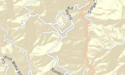


7 PROJECT LOCATION ± 0 2,000 4,000 8,000 Feet Source: ESRI World Street Map CRUMMER PIPELINE CONSTRUCTION PROJECT Project Location Map Exhibit 1


8 Legend /NNG CHAP - Chaparral CSS - Coastal Sage Scrub DEV - Devloped - Disturbed Coastal Sage Scrub CSS - Fountain Grass /NNG - Fountain Grass/Non-Native Grassland Mosaic - Ornamental OW - Ornamental Woodland - Ruderal T - Turf CSS CHAP T/ - Turf/Ornamental T/ T DEV DEV Vegetation/Land Cover Acres Chaparral 2.23 Coastal Sage Scrub Devloped Disturbed Coastal Sage Scrub 8.58 Fountain Grass 5.16 Fountain Grass/Non-Native Grassland Mosaic 4.68 Ornamental 3.70 Ornamental Woodland 1.41 Ruderal Turf Turf/Ornamental 0.29 Total CSS CHAP T ± Civic Center Way OW Feet Pacific Coast Highway CRUMMER PIPELINE CONSTRUCTION PROJECT Vegetation/Land Cover Types Map Exhibit 2
FIGURE 1 PHOTOSTATION PHOTOGRAPHS, FORT ORD RARE PLANT SURVEY, OPERABLE UNIT 1. CH2MHILL. Photograph 1: View of access road, looking northeast.
 Photograph 1: View of access road, looking northeast. Photograph 2: View of access road, looking to the southwest. Note there are open areas with sandy soils with annual grasses and fi laree within and
HABITAT RESTORATION PLAN FOR WHITE POINT LANDSLIDE REPAIR
 HABITAT RESTORATION PLAN FOR WHITE POINT LANDSLIDE REPAIR MITIGATION OCTOBER 30, 2014 1 INTRODUCTION This habitat restoration plan was prepared for the White Point Nature Preserve, for 1.5 acres that were
ZANDER ASSOCIATES Environmental Consultants
 ZANDER ASSOCIATES Environmental Consultants June 23, 2011 Massy Mehdipour 1425 Dana Ave. Palo Alto, CA 94301 Supplemental Biological Resource Assessment 1170 Signal Hill Road Pebble Beach, Monterey County,
Merkel & Associates, Inc Ruffin Road, San Diego, CA Tel: 858/ Fax: 858/
 Merkel & Associates, Inc. 5434 Ruffin Road, San Diego, CA 92123 Tel: 858/560-5465 Fax: 858/560-7779 e-mail: associates@merkelinc.com February 23, 2009 M&A # 08-021-02 Ms. Staci Merriman Metropolitan Wastewater
Trestles Wetlands Natural Preserve Plant Communities. Plant Community Site Map from Feldmeth (1987):
:") Trestles Wetlands Natural Preserve Plant Communities Plant Community Site Map from Feldmeth (1987): In the definitive study Biological Resources of the San Mateo Creek Area (Feldmeth, 1987), the primary
Trestles Wetlands Natural Preserve Plant Communities Plant Community Site Map from Feldmeth (1987): In the definitive study Biological Resources of the San Mateo Creek Area (Feldmeth, 1987), the primary
ADDENDUM TO BIOLOGICAL SCOPING SURVEY REPORT, BOTANICAL SURVEY AND WETLAND DELINEATION
 ADDENDUM TO BIOLOGICAL SCOPING SURVEY REPORT, BOTANICAL SURVEY AND WETLAND DELINEATION FOR AVALON INN (APN 069-241-27 & -04) 1201 & 1211 NORTH MAIN STREET FORT BRAGG, CA MENDOCINO COUNTY prepared for:
5.1 AESTHETICS AND VISUAL RESOURCES Physical Setting
 5.1 AESTHETICS AND VISUAL RESOURCES 5.1.1 Physical Setting Aesthetic values are an important aspect in establishing the identity, sense of place, and quality of life in a community. Natural features in
THREE SISTERS RESERVE HABITAT RESTORATION PLAN
 FINAL THREE SISTERS RESERVE HABITAT RESTORATION PLAN Prepared for: Palos Verdes Peninsula Land Conservancy 916 Silver Spur Road, Suite 207 Rolling Hills Estates, California 90274 Prepared by: EARTHWORKS
VICENTE BLUFFS RESERVE FISHING ACCESS TRAIL HABITAT RESTORATION PLAN
 FINAL VICENTE BLUFFS RESERVE FISHING ACCESS TRAIL HABITAT RESTORATION PLAN Prepared for: Palos Verdes Peninsula Land Conservancy 916 Silver Spur Road, Suite 207 Rolling Hills Estates, California 90274
F ADJUSTMENTIDESIGN REVI~ vv BOARD PROJECT OVERVIEW
 BOAR F ADJUSTMENTIDESIGN REVI~ vv BOARD PROJECT OVERVIEW CASE: LOCATION: REQUESTED ACTION: CEQA: EXISTING APPROVALS: ZONING: ADDITIONAL REFERENCES: REQUIRED FINDINGS: ATTACHMENTS: STAFF COMMENTS: DESIGN
Draft TISCORNIA ESTATE SPECIFIC PLAN/EIR
 Draft TISCORNIA ESTATE SPECIFIC PLAN/EIR Submitted CONTENTS 1. PLAN SUMMARY II. INTRODUCTION IX. SPECIFIC PLAN RELATIONSHIPS X. XI. List of Figures 1. Regional Location 2. Point Richmond Area 3. Planning
Public Review Draft Oceanside Subarea Habitat Conservation Plan/ Natural Communities Conservation Plan
 Oceanside Subarea Habitat Conservation Plan/ Natural Communities Conservation Plan Prepared for City of Oceanside Planning Department 300 N. Coast Highway Oceanside, CA 92054 Prepared by Ogden Environmental
 FIGURE 1. PROJECT VICINITY MAP : City of Vista storm water conveyance system maintenance project locations, Guajome Creek mitigation site. TABLE 1. 22 SUMMARY OF PROJECT DESCRIPTION AND CORPS JURISDICTIONAL
Burrowing Owl Habitat Project at the Albany Plateau. (a component project of the Gilman Street Playing Fields Project City of Berkeley) March 10, 2006
 March 10, 2006") Burrowing Owl Habitat Project at the Albany Plateau (a component project of the Gilman Street Playing Fields Project City of Berkeley) March 10, 2006 Submitted by The City of Berkeley Project history During
Burrowing Owl Habitat Project at the Albany Plateau (a component project of the Gilman Street Playing Fields Project City of Berkeley) March 10, 2006 Submitted by The City of Berkeley Project history During
Abalone Cove Ecological Reserve in the Portuguese Bend Nature Preserve
 Habitat Restoration Plan for the Abalone Cove Ecological Reserve in the Portuguese Bend Nature Preserve FEBRUARY 2016 P R E P A R E D B Y : Palos Verdes Peninsula Land Conservancy 916 Silver Spur Road,
CHINO HILLS CHINO HILLS. September 6, 2012 OPEN SPACE MANAGEMENT PLAN
 September 6, 2012 Welcome! Today s Agenda Introduction Purpose and Scope of the Open Space Management Plan Where Have We Been? Presentation of Preliminary Findings Exercise: Issue identification and Priority
5. Environmental Analysis
 5.3 BIOLOGICAL RESOURCES 5.3.1 Methodology The following assessment of biological resources is based on historical information compiled through previous documentation and appropriate reference materials.
SmartScape Design Provides Improved Avian Habitat
 SmartScape Design Provides Improved Avian Habitat Andrea D. Haller, M.S. Stivers & Associates, Inc. June 2012 INTRODUCTION Conventional landscaping primarily consists of monoculture non-native grasses
PLANTS PROFILES: SATURDAY, FEBRUARY 20 TH CSUSB WORKSHOP ARTEMESIA CALIFORNICA/CALIFORNIA SAGEBRUSH
 PLANTS PROFILES: SATURDAY, FEBRUARY 20 TH CSUSB WORKSHOP ARTEMESIA CALIFORNICA/CALIFORNIA SAGEBRUSH Size: 3-4 high; 3-4 wide Flowers: None Foliage: gray-green; stress-deciduous Water: drought-tolerant
What to Plant for Birds
 What to Plant for Birds Ariana Longanecker Alonganecker @audubonportland.org Gaylen Beatty gbeatty@columbialandtrust.org Mission of Backyard After-2010 Gold Certified Before 2009 Backyard Habitat Certification
Planning and Building Inspection Department Mitigation Monitoring Reporting Plan (MMRP) Potrero Subdivision Santa Lucia Preserve
 Potrero Subdivision Santa Lucia Preserve") Planning and Building Inspection Department Mitigation Monitoring Reporting Plan (MMRP) Potrero Subdivision Santa Lucia Preserve Project Name: Potrero Area Subdivision File No: PLN010001 APNs: 239-102-001-000;
Planning and Building Inspection Department Mitigation Monitoring Reporting Plan (MMRP) Potrero Subdivision Santa Lucia Preserve Project Name: Potrero Area Subdivision File No: PLN010001 APNs: 239-102-001-000;
IV.B. VISUAL RESOURCES
 IV.B. VISUAL RESOURCES ENVIRONMENTAL SETTING Existing Visual Character Project Site The project site is located at 17331-17333 Tramonto Drive in the Pacific Palisades community of the City of Los Angeles
III. PROJECT DESCRIPTION
 III. PROJECT DESCRIPTION A. PROJECT LOCATION Regional Setting The project site is located in the southeast quadrant of the City of Chico in Butte County, California and is comprised of four parcels totaling
Morro Shoulderband Snail Protocol Survey Report for the Parcel at 3093 Beachcomber Drive, Morro Bay, San Luis Obispo County, California
 Morro Shoulderband Snail Protocol Survey Report for the Parcel at 3093 Beachcomber Drive, Morro Bay, San Luis Obispo County, California Prepared for: John K. Construction Inc. Prepared by: SWCA Environmental
Stormwater Standards. Clackamas County Service District No. 1. Planting Guide for Buffers
 Stormwater Standards Clackamas County Service District No. 1 APPENDIX B Planting Guide for Buffers Table of Contents Appendix B - Planting Guide for Buffers... Page B.1 General... 1 B.1.1 Introduction...
Nob Hill Pipeline Improvements Project EIR
 Section 3.1 Aesthetics This section addresses the visual aspects that may affect the views experienced by the public, including the potential to impact the existing character of each area that comprises
Vegetation Assessment Report OROVISTA AVENUE NORTH OF BIG TUJUNGA CANYON ROAD (W.O. E )
") Vegetation Assessment Report PROJECT: Prepared by: OROVISTA AVENUE NORTH OF BIG TUJUNGA CANYON ROAD (W.O. E6000347) William Jones, Environmental Supervisor I Bureau of Engineering, Environmental Management
Vegetation Assessment Report PROJECT: Prepared by: OROVISTA AVENUE NORTH OF BIG TUJUNGA CANYON ROAD (W.O. E6000347) William Jones, Environmental Supervisor I Bureau of Engineering, Environmental Management
COMMUNITY DEVELOPMENT SERVICES PLANNING AND BUILDING DEPARTMENT PLACERVILLE OFFICE:
 COMMUNITY DEVELOPMENT SERVICES PLANNING AND BUILDING DEPARTMENT http://www.edcgov.us/devservices/ PLACERVILLE OFFICE: LAKE TAHOE OFFICE: 2850 Fair Lane Court, Placerville, CA 95667 924 B Emerald Bay Rd.
Goleta Community Plan Update
 Goleta Community Plan Update Ecology, Biology, and Habitats GVPAC Meeting Agenda [Wednesday, December 17, 2008, 6:00PM] Pledge of Allegiance and Roll Call Public Comment Period Administrative December
3.10 LAND USE SETTING PROJECT SITE EXISTING LAND USE DESIGNATIONS AND ZONING. General Plan Land Use Designations.
 This section of the Draft EIR addresses the existing land uses on and adjacent to the project site and discusses the potential impacts of the proposed project on existing land uses. Key issues addressed
Exhibit 16 Stormwater Management and Erosion & Sedimentation Control
 TYPE S1 TYPE S1 TYPES S2 and S2A Exhibit 16 Stormwater Management and Erosion & Sedimentation Control EXHIBIT 16 STORMWATER MANAGEMENT & EROSION AND SEDIMENTATION CONTROLS Motherhouse Senior Housing Subdivision
Nearby Features (Water body, T&E Habitat, Wetlands, Noxious Weed):
:") Variance Request Form Company: Avangrid Renewables Variance: VAR-016 Address: 1125 NW Couch Street, Suite 700 Request No.: Rev 0 City, State, Zip : Portland, OR, 97209 Date Submit: 07/07/17 Date Agency
Variance Request Form Company: Avangrid Renewables Variance: VAR-016 Address: 1125 NW Couch Street, Suite 700 Request No.: Rev 0 City, State, Zip : Portland, OR, 97209 Date Submit: 07/07/17 Date Agency
Table of Contents TABLE OF CONTENTS SECTION TITLE PAGE
 TABLE OF CONTENTS SECTION TITLE PAGE 1 INTRODUCTION AND OVERVIEW 1-1 1.1 Purpose and Need 1-1 1.2 Goals and Objectives 1-3 1.3 Overview of the Planning Process 1-5 1.4 Federal and State Requirements and
3.1 Aesthetics, Light, and Glare
 3.1 3.1.1 Introduction This section describes the existing aesthetics, light, and glare setting and potential effects from project implementation on visual resources and the site and its surroundings.
STATE OF NORTH CAROLINA DECLARATION OF
 Prepared by and Return to: Orange County Parcel Identification Number(s): STATE OF NORTH CAROLINA COUNTY OF ORANGE DECLARATION OF RESTRICTIVE COVENANTS THIS DECLARATION OF RESTRICTIVE COVENANTS ( Declaration
Towne Park Estates Subdivision Phase II
 Towne Park Estates Subdivision Phase II ENVIRONMENTAL NARRATIVE October 21, 2014 Submitted to: Submitted by: Horner Environmental Professionals, Inc. 4252 Hay Road Lutz, Florida 33559 HEP TOWNE PARK ESTATES
APPENDIX C NATURAL RESOURCES MANAGEMENT PLAN: ACTIONS AND PRIORITIES
 APPENDIX C NATURAL RESOURCES MANAGEMENT PLAN: ACTIONS AND PRIORITIES TABLE C-1: Resource Actions and Priorities GOAL NRM-4 Objective 4.1: Restore Natural floodplain functions. Objective 4.2: Define and
Land at Whiteditch Lane, Newport, Essex
 Land at Whiteditch Lane, Newport, Essex Ecology Report Produced for Sworders Agricultural By March 2013 Document Control: Version Date Version Details Prepared by Checked by Approved by 0.1 01.03.2013
Meeting Agenda. City of Guelph. River Systems Advisory Committee. Agenda Items. Item 1, 2 and 3. Item 4 Ward to Downtown Pedestrian Bridge
 Meeting Agenda City of Guelph River Systems Advisory Committee September 19, 2018 City Hall, Meeting Room B From 4:00 to 6:00 p.m. Meeting Chair: Mariette Pushkar Agenda Items Welcome to all Item 1, 2
Verde Valley Landscape Character Type
 Existing Condition Landscape Character The existing landscape character describes the existing set of valued aesthetic attributes for the current landscape. The landscape character descriptions include
Conservation Plan. I. Property Information. II. Objectives. Natural Resource Objectives. Sustainability in Practice (SIP) Certified
 Certified") Conservation Plan Sustainability in Practice (SIP) Certified I. Property Information Vineyard Name and Establishment Date: Location: Map (attach showing blocks and acres): II. Objectives Natural Resource
Conservation Plan Sustainability in Practice (SIP) Certified I. Property Information Vineyard Name and Establishment Date: Location: Map (attach showing blocks and acres): II. Objectives Natural Resource
RD:VMT:JMD 10/14/2015 RESOLUTION NO.
 RD:VMT:JMD 10/14/2015 RESOLUTION NO. A RESOLUTION OF THE COUNCIL OF THE CITY OF SAN JOSE ADOPTING THE EDENVALE AVENUE PLANNED DEVELOPMENT REZONING PROJECT MITIGATED NEGATIVE DECLARATION, FOR WHICH AN INITIAL
PICTURE CANYON Planning Riparian-Wetland Refugia in an Urban Setting
 PICTURE CANYON Planning Riparian-Wetland Refugia in an Urban Setting Rio De Flag Existing Conditions. Ephemeral stream; Limited riparian plants, habitats.. & Opportunities Water (effluent) available Restore
Invasive Plants. Batiquitos Lagoon
 Invasive Plants of Batiquitos Lagoon A Field Guide created by the Batiquitos Lagoon Foundation Summer Interns of the San Dieguito Academy ECO Club July 24 th, 2012 Table of Contents Iceplant (Carpobrotus
MITIGATION MANAGEMENT AND MONITORING PLAN BAYFRONT PARK WETLAND RESTORATION MILL VALLEY, CA
 MITIGATION MANAGEMENT AND MONITORING PLAN BAYFRONT PARK WETLAND RESTORATION MILL VALLEY, CA PREPARED FOR: THE CITY OF MILL VALLEY PARKS AND RECREATION DEPARTMENT 180 CAMINO ALTO AVENUE MILL VALLEY, CA
Section 3 INVENTORY OF RECREATION LAND AND FACILITIES
 Photo of Juan Bautista de Anza Park Section 3 INVENTORY OF RECREATION LAND AND FACILITIES Summary of Findings Park Definitions Summary of Recreation Facilities Other Recreation Facilities Nearby Recreation
3 Principles. Principles and Practices. Chapter THREE. & Practices. Russian River-Friendly Landscape Features:
 Chapter THREE 3Russian River-Friendly Landscaping Principles and Practices 15 16 12 13 11 14 9 17 8 4 2 3 1 10 7 5 6 Russian River-Friendly Landscape Features: 1 Permeable paving on driveway and walkway
MITIGATION MONITORING PROGRAM (Accompanies the Aliso Canyon Park Improvements Project Initial Study (IS)/Mitigated Negative Declaration (MND))
/Mitigated Negative Declaration (MND))") TRANSMITTAL NO. 2 MITIGATION MONITORING PROGRAM (Accompanies the Aliso Canyon Park Improvements Project Initial Study (IS)/Mitigated Negative Declaration (MND)) ALISO CANYON PARK IMPROVEMENTS PROJECT (W.O.
TRANSMITTAL NO. 2 MITIGATION MONITORING PROGRAM (Accompanies the Aliso Canyon Park Improvements Project Initial Study (IS)/Mitigated Negative Declaration (MND)) ALISO CANYON PARK IMPROVEMENTS PROJECT (W.O.
NOTICE OF PREPARATION
 NOTICE OF PREPARATION DATE: January 6, 2016 TO: LEAD AGENCY: Responsible Agencies, Organizations, and Interested Parties Contact: Tyler Barrington, Principal Planner Planning Department Community Development
JOINT PUBLIC NOTICE. 26 June United States Army Corps of Engineers State of Louisiana
 JOINT PUBLIC NOTICE 26 June 2017 United States Army Corps of Engineers State of Louisiana New Orleans District Department of Environmental Quality Regulatory Branch Office of Environmental Services 7400
RIPARIAN HABITAT RESTORATION. Helen Swagerty Senior Restoration Biologist/Project Manager
 RIPARIAN HABITAT RESTORATION Helen Swagerty Senior Restoration Biologist/Project Manager RIVER PARTNERS: OUR HISTORY Synergy between the fields of ecological restoration and agriculture 3 Offices: Chico,
Harbor Boulevard Wildlife Underpass, Los Angeles County, California
 Harbor Boulevard Wildlife Underpass, Los Angeles County, California INTRODUCTION Wildlife in the Los Angeles Basin now can cross between open space areas on either side of a busy boulevard due to a collaborative
SITE INTRODUCTIONS AND OVERVIEW
 SITE INTRODUCTIONS AND OVERVIEW The City s formal Open Space Program was established in 1990 to implement long-standing policies that called for the protection of the farmlands and wild areas that surround
BEST MANAGEMENT PRACTICES Spurge Laurel(Daphne laureola) (Family Thymelaeaceae Daphne Family)
 (Family Thymelaeaceae Daphne Family)") JEFFERSON COUNTY NOXIOUS WEED CONTROL BOARD 380 Jefferson Street, Port Townsend WA 98368 360 379-5610 Ext. 205 noxiousweeds@co.jefferson.wa.us BEST MANAGEMENT PRACTICES Spurge Laurel(Daphne laureola) (Family
JEFFERSON COUNTY NOXIOUS WEED CONTROL BOARD 380 Jefferson Street, Port Townsend WA 98368 360 379-5610 Ext. 205 noxiousweeds@co.jefferson.wa.us BEST MANAGEMENT PRACTICES Spurge Laurel(Daphne laureola) (Family
BISCUIT RUN PARK MASTER PLAN
 BOARD OF SUPERVISORS November 14, 2018 BISCUIT RUN PARK MASTER PLAN COUNTY OF ALBEMARLE ANHOLD ASSOCIATES Contents Project Introduction Property Background County Park Planning Process Existing Site &
CITY OF MALIBU PLANNING COMMISSION RESOLUTION NO
 CITY OF MALIBU PLANNING COMMISSION RESOLUTION NO. 16-54 A RESOLUTION OF THE PLANNING COMMISSION OF THE CITY OF MALIBU, CONSIDERING AN ADDENDUM TO THE CERTIFIED CRUMMER SITE SUBDIVISION FINAL EIR AND MAKING
BEAUTIFUL CALIFORNIA NATIVES. Deva Luna EarthCare Landscaping
 SUSTAINABLE WATERWISE GARDENING LANDSCAPING WITH BEAUTIFUL CALIFORNIA NATIVES Deva Luna EarthCare Landscaping 408-871-2792 WHY NATIVES? California has a very unique flora Plants and pollinators interdependent
HABITAT ACQUISITION TRUST
 HABITAT ACQUISITION TRUST Plan for Nesting Habitat Rehabilitation for the Western Painted Turtle at Swan Lake Nature Sanctuary Suite 316, 620 View St PO Box 8552 Victoria, B.C. V8W 3S2 Tel: (250) 995.2428
Riparian Buffer on the Bushkill Creek. Policies
 Riparian Buffer on the Bushkill Creek Riparian buffers provide numerous benefits to landowners and the community by protecting groundwater recharge areas, providing flood control, providing stormwater
PLANNING COMMISSION. Submitted
 PLANNING COMMISSION City Hall 1275 Main Street El Centro, CA 92243 Submitted PLANNING COMMISSION ACTION ITEM (1844) Meeting: 05/10/16 12:00 AM Department: Community Development Category: Public Hearing
New Student Housing Draft EIR Public Meeting
 New Student Housing Draft EIR Public Meeting May 8, 2017 Meeting Overview Purpose of Meeting Sophomore Success Project Objectives Alternatives Project Site/Design Overview Biological Resource Impacts/Mitigation
APPENDIX C SPECIAL PLANNING AREAS
 SPECIAL PLANNING AREAS There are five Special Planning Areas (SPAs) on the Land Use Diagram (Figure LU-2). The SPAs are areas with significant new growth potential that require more detailed subsequent
MEMORANDUM OF BOG TURTLE HABITAT INVESTIGATION
 MEMORANDUM OF BOG TURTLE HABITAT INVESTIGATION 410-728-2900 Fax: 410-728-3160 www.rkk.com To: From: CC: U.S. Fish and Wildlife Service, Pennsylvania Fish and Boat Commission Jennifer A Ottenberg Miller,
What is the EDPA? The EDPA has three objectives: 1. Protect biodiversity. 2. Mitigate damage during development. 3. Restore degraded ecosystems
 What is the EDPA? Environmental Development Permit Areas are the best tool available to municipalities to protect ecosystems and habitat on private land. The EDPA has three objectives: 1. Protect biodiversity
NOTICE OF PREPARATION
 Date: June 30, 2017 CITY OF CITRUS HEIGHTS COMMUNITY & ECONOMIC DEVELOPMENT DEPARTMENT, PLANNING DIVISION 6360 Fountain Square Drive, Citrus Heights, CA 95621 (916) 727-4740 NOTICE OF PREPARATION To: Subject:
Proposed Residential Development at Church Stile Farm in Cradley, Herefordshire. Hazel Dormouse Surveys
 Proposed Residential Development at Church Stile Farm in Cradley, Herefordshire A report to: Terra Strategic BSL Strategic Ltd. 2 The Courtyard 707 Warwick Road Solihull B91 3DA By: Udall-Martin Associates
I. INTRODUCTION. A. Project Location
 Mountain Park pecific Plan I. INRODUCION A. Project Location he proposed Mountain Park pecific Plan project site is located generally in Gypsum Canyon, south of the Riverside (R-91) Freeway, in the City
California State University, Monterey Bay Campus Parking Relocation Project Attachment to Notice of Exemption
 California State University, Monterey Bay Campus Parking Relocation Project Attachment to Notice of Exemption California State University, Monterey Bay (CSUMB) proposes to improve an existing oncampus
City of Lafayette Study Session Staff Report Design Review Commission
 City of Lafayette Study Session Staff Report Design Review Commission Meeting Date: April 24, 2017 Staff: Payal Bhagat, Senior Planner Subject: HDP18-15 & HDP31-15 Ramesh Patel & Melcor Development (Owners),
The Napa River Flood Protection Project
 The Napa River Flood Protection Project Creating Flood Protection and Restoring Geomorphic and Biological Processes Jeremy Sarrow, Napa County Flood Control & Water Conservation District June 2, 2014.
Study Area Map. Wasatch Hollow Open Space Restoration, Use, & Management Plan. Legend. Harrison Ave East. Roosevelt East.
 Harrison Ave Roosevelt Emerson «4 «5 Rosecrest 1900 East «3 1800 East Wasatch Hollow Open Space Restoration, Use, & Management Plan Study Area Map Legend «2 «1 Potential Access Location Emigration Creek
PARK CITY MUNICIPAL CODE TABLE OF CONTENTS TITLE 15 LAND MANAGEMENT CODE - CHAPTER 2.21
 PARK CITY MUNICIPAL CODE TABLE OF CONTENTS TITLE 15 LAND MANAGEMENT CODE - CHAPTER 2.21 TITLE 15 - LAND MANAGEMENT CODE CHAPTER 2.21 - SENSITIVE LAND OVERLAY ZONE (SLO) REGULATIONS 15-2.21-1. PURPOSE...1
CITY PLANNING COMMISSION AGENDA ITEM: C STAFF: ROBERT TEGLER FILE NO: CPC PUD QUASI-JUDICIAL
 CPC AGENDA June 8, 2006 Page 37 CITY PLANNING COMMISSION AGENDA ITEM: C STAFF: ROBERT TEGLER FILE NO: CPC PUD 05-294 - QUASI-JUDICIAL PROJECT: APPLICANT: OWNER: PARKWOOD AT WOLF RANCH NASS DESIGN ASSOCIATES
3.2 AESTHETICS/VISUAL QUALITY
 3.2 AESTHETICS/VISUAL QUALITY This section evaluates the potential impacts of the proposed project on the existing visual conditions within MTRP. Design features proposed to reduce or avoid adverse effects
Policy & Procedure Effective Date: Parks Department Page of
 City of Arvada Policy & Procedure Effective Date: Parks Department Page of TITLE: City of Arvada Prairie Dog Habitat Plan APPROVAL: PURPOSE: To establish a plan for the preservation of black-tailed prairie
File No (Continued)
") (Continued) Request for: (1) a Site Plan Review; (2) a Variance (to build on a significant ridgeline); (3) an Oak Tree Permit (to encroach into the protected zone of 25 oak trees and for potential thinning
(Continued) Request for: (1) a Site Plan Review; (2) a Variance (to build on a significant ridgeline); (3) an Oak Tree Permit (to encroach into the protected zone of 25 oak trees and for potential thinning
APPENDIX A 6 CONCEPTUAL PRELIMINARY PLAN GUIDE AND CHECKLIST FOR MAJOR SUBDIVISIONS CARRBORO DEVELOPMENT GUIDE APPENDIX A
 6 CONCEPTUAL PRELIMINARY PLAN GUIDE AND CHECKLIST FOR MAJOR SUBDIVISIONS Conceptual Preliminary Guide/Checklist for Major Subdivisions Page 1 FORM: REVIEW DATE: CONCEPTUAL PLAN REVIEW 2000 REVIEWED BY:
SPG 1. * the northern and western sections which are open fields used for pasture and grazing;
 SPG 1 1.0 INTRODUCTION This development brief is based on the allocation of the Priors Hall site for employment and countryside recreational purposes in the Corby Borough Local Plan. The brief is intended
Oak View Estates Specific Plan
 Oak View Estates Specific Plan Environmental Impact Report SCOPING MEETING MARCH 14, 2018 CITY OF BRADBURY PLANNING DEPARTMENT Welcome and Project Team Kevin Kearney, City Manager Jim Kasama, City Planner
Sheet Index. Legal Description. General Notes: Vicinity Map Scale 1" = 600'
 LOCATED IN THE SOHWEST QUARTER OF SECTION, TOWNSHIP SOH, Case # Z 6 - Legal Description Tract G, H and J of the Villages at Riverdale Filing No., a part of the Southwest quarter of Section, Township South,
6Natural. Environment Development Permit Guidelines
 6Natural Bylaw 2600-2016, being "Official Community Plan Bylaw, 2016" Schedule "A" CITY OF ABBOTSFORD OFFICIAL COMMUNITY PLAN Environment Development Permit Guidelines Part V - 6-1 Area Subdivision or
143 Flinders Avenue Lara. Vegetation Assessment
 143 Flinders Avenue Lara Vegetation Assessment A Report to L. Bisinella Developments Pty Ltd Prepared by Mark Trengove Ecological Services PO Box 1502 Geelong 3220 mtrengove@pipeline.com.au ph 0428 298087
Wildlife Ecology Internship at Point Reyes National Seashore
 Wildlife Ecology Internship at Point Reyes National Seashore guidance of the Wildlife Program of the Integrated Resources Division at Point Reyes National Seashore and assist in documenting and assessing
Notice of Preparation of an Environmental Impact Report and Scoping Meeting for the Canyon Lane Roadway Improvements Development Project
 of an Environmental Impact Report and Scoping Meeting for the As the Lead Agency, the County of San Mateo (County) will prepare an Environmental Impact Report (EIR) for the (project), and would like your
RESOLUTION NO
 RESOLUTION NO. 2018- RESOLUTION OF THE PLANNING COMMISSION OF THE CITY OF BELMONT APPROVING A SINGLE-FAMILY DESIGN REVIEW AND TREE REMOVAL PERMIT FOR A VACANT LOT ON LOWER LOCK AVENUE (APN: 043-042-750,
CHAPTER 10 AESTHETICS
 CHAPTER 10 AESTHETICS CHAPTER 10 AESTHETICS This section identifies and evaluates key visual resources in the project area to determine the degree of visual impact that would be attributable to the project.
SECTION 5.9 Fire Protection
 SECTION 5.9 Fire Protection 5.9 FIRE PROTECTION This section provides an analysis of fire protection services, which is based on information provided by the Los Angeles County Fire Department (LACFD).
Devil s Slide Coastal Trail Improvements Project. County of San Mateo
 County of San Mateo Project History Measure T Nov.1996 Plans and Permits Task Force meetings Hired a team Board support Budget Project Overview Programming and Linkages Park hours Multi use trail Pedestrians
PRE-DESIGN CONCEPT REPORT GRAND CANAL RESTORATION
 PRE-DESIGN CONCEPT REPORT GRAND CANAL RESTORATION Project Background November 19, 2007 Executive Summary The Grand Canal is an important tidal waterway in the Venice community of Los Angeles, California,
CHAPTER 15 AESTHETICS. Setting. Introduction. Impacts and Mitigation Measures of the 2015 Plan Alternatives
 CHAPTER 15 AESTHETICS Introduction Setting Impacts and Mitigation Measures of the 2015 Plan Alternatives CHAPTER 15 AESTHETICS INTRODUCTION Public acceptance of a project may be strongly influenced by
Development. Within of 25% or greater. ridges anticipated that the. foundations. and walk out. Page 1 of 4
 Ridge Estates May 11, 2016 LAND SUITABILITY ANALYSIS REPORT 1. INTRODUCTION This report is provided in accordance with the submittal requirements of the Planned Development Plan (PPD). The report accompanies
MSHCP Determination of Biologically Equivalent or Superior Preservation/Consistency Analysis
 MSHCP Determination of Biologically Equivalent or Superior Preservation/Consistency Analysis Project - City of Perris Western Riverside County, California FINAL REPORT Prepared for: Albert A. Webb Associates
las vegas wash coordination committee
 las vegas wash coordination committee lvwash.org DU Wetlands No. 1 Weir Planting Plan February 2013 DU Wetlands No. 1 Weir Planting Plan SOUTHERN NEVADA WATER AUTHORITY Las Vegas Wash Project Coordination
Invasive Plants- A Concern for Hunter and Non-Hunter Alike
 Invasive Plants- A Concern for Hunter and Non-Hunter Alike Invasive Plant Species Causing serious problems in forests! Eliminating native understory plants Out competing & displacing native tree species
Principles for Ecological Landscape Design in Brownfield Business Parks
 Principles for Ecological Landscape Design in Brownfield Business Parks Part of USDA Forest Service research project # 00-JV-11231300-033: Aligning Social and Ecological Drivers of Urban Landscape Change
4.1 AESTHETICS EXISTING ENVIRONMENTAL SETTING ALAMITOS BAY MARINA REHABILITATION PROJECT CITY OF LONG BEACH
 4.1 AESTHETICS This section provides a discussion of the existing visual and aesthetic resources on site and in the surrounding area as well as an analysis of potential impacts from implementation of the
WETLAND SOD u Bare Root Wetland Plants u Deep Rooted Willows u Coir Logs u Native Trees & Shrubs u Habitat Islands u Custom Growing
 WETLAND SOD u Bare Root Wetland Plants u Deep Rooted Willows u Coir Logs u Native Trees & Shrubs u Habitat Islands u Custom Growing 2009 PROJECT HIGHLIGHTS The following 10 projects highlight the interesting
6.3 VISUAL RESOURCES. Landscape Character
 6.3 VISUAL RESOURCES 6.3.1 Affected Environment The DMR discussion is divided into two areas, DMR and Dillingham Trail, which would extend from SBMR to DMR. The ROI includes all areas within the line of
SUSSEX COUNTY COMPREHENSIVE PLAN COUNTY PLANNING AND ZONING COMMISSION WORKSHOP
 SUSSEX COUNTY COMPREHENSIVE PLAN COUNTY PLANNING AND ZONING COMMISSION WORKSHOP August 21, 2017 TODAY S WORKSHOP Public Comment Utilities Update Economic Development Update Future Land Use Discussion Public
Notice of Preparation and Notice of Public Scoping Meeting. At Dublin Project
 Notice of Preparation and Notice of Public Scoping Meeting Date January 17, 2018 To Project Title Project Application Number Project Location Project Applicant Contact For questions or submitting comments.