Vegetation Assessment Report OROVISTA AVENUE NORTH OF BIG TUJUNGA CANYON ROAD (W.O. E )
|
|
|
- Walter Baldwin
- 5 years ago
- Views:
Transcription
 within Big Tujunga Canyon Wash in the vicinity of")
1 Vegetation Assessment Report PROJECT: Prepared by: OROVISTA AVENUE NORTH OF BIG TUJUNGA CANYON ROAD (W.O. E ) William Jones, Environmental Supervisor I Bureau of Engineering, Environmental Management Group (EMG). Report Date: May 23, 2013 Photo 1 Introduction The City of Los Angeles proposes to perform maintenance (channel realignment and grading of sediments) within Big Tujunga Canyon Wash in the vicinity of Oro Vista Avenue and within the Community of Sunland. The area of treatment includes channels to the east of the Oro Vista overcrossing, and culvert outlets lying, just to the west (Figure A). At the northern end of the Oro Vista Avenue Crossing, an existing bridge spans the perennial stream channel of Big Tujunga Canyon. The existing ephemeral creek bed will be graded to control flow into the culverts under the Oro Vista crossing. To accomplish this, some existing vegetation will need to be removed from within the maintenance zone. The gross project area covers about 0.67 hectares (1.66 acres). The purpose of this study is to provide a record of existing vascular plant species, and characterize their vegetation communities, which may be affected, assess the significance of that impact and, if appropriate, recommend mitigation measures. Information from this report will also be used to prepare environmental permit applications, and/or mitigation measures for the loss of vegetation from the impacted areas. Location Description The project site is located in the bottom of Big Tujunga Wash (Figure B), in the community of Sunland. The wash drains the southwestern San Gabriel Mountains. The approximate 1
2 site elevation ranges from 395 to 398 meters (1,297 to 1,306 feet), above mean sea-level (Sunland 7.5 minute quadrangle). Current Conditions The perennial stream channel of Big Tujunga Canyon flows southward to the northwest of the project site. An overflow or bypass channel runs north to south through the western portion of the project site. Within the potential maintenance-impact zone, both disturbed and less disturbed habitats were present. Since construction of the roadway, adjacent areas have been frequently cleared or disturbed by flooding. Bare areas were common. Boulders and cobbles are interspersed within a matrix of unsorted sands, gravels and silts. Several large berms, comprising similar materials, lie to the northeast of the existing roadway. Numerous pioneer and alien, weedy, species are common in the disturbed areas. Native vegetation fringes upon and has re-invaded some of the previously disturbed areas. Methods The floristic survey was conducted on May1, A follow up visit was made on May 17, EMG performed previous surveys at this location in 1997, 2006, and All vascular plant species were recorded, and California native plant species noted, within the designated maintenance zone. The potentially impacted area extends approximately 60 meters (200 feet) upstream, and approximately 15 meters (50 feet) downstream from Oro Vista Avenue. Some realignment work may be required to maintain the perennial stream channel, at a point upstream, about 1,000 meters (3,000 feet) to the east. The survey was conducted by walking the project area and recording all vascular plant species encountered. Fresh voucher specimens, of problem plant species, were collected for identification. Nomenclature followed Munz (1974) and Baldwin, et al. (2012). Other references CALFLORA (2013), CNPS (2013), Consortium of California Herbaria (2013), Jones (1997), McMinn (1964), McMinn and Maino (1967), Raven et al. (1986 edition), Vasek (1982), Watson and Dalwitz ( ) and Whitson (1992) - were also used. Based upon the results, native California plant species, which appeared on the California Department of Fish and Game list of state and federally designated, rare and endangered plants, were to be noted and precautions taken for their preservation or replacement. Native plant species were checked against the December 1995 version of the California Native Plant Society's electronic inventory of rare and endangered vascular plants of California (Skinner and Pavlik, eds. 1994). The inventory includes the state ( 1904, Ch. 10 of the Native Plant Protection Act or and of the California Endangered Species Act) and federal legal status (50 CFR 17.12) for each listed, rare and endangered plant. 2
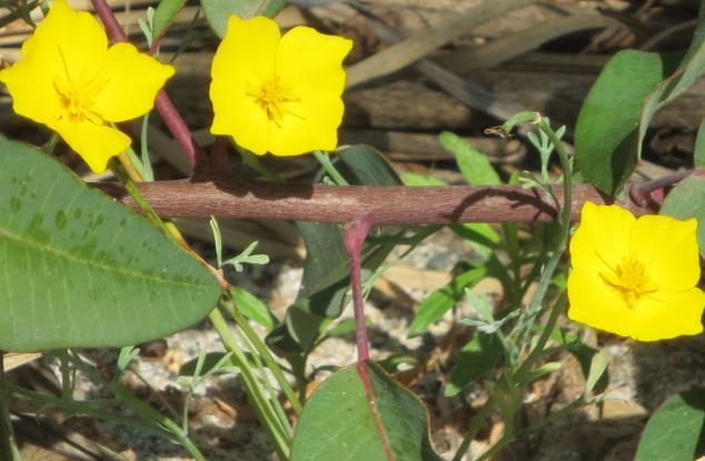
3 The plant species list will be used to prepare re-vegetation plans for the impacted maintenance areas. In the ephemeral stream channel, mature, native trees, in excess of 7.6 cm (3 inches) in diameter, are to be replaced. Results Outside of the maintenance zone, the native vegetation forms a mosaic of sclerophyllic evergreen shrubs with a few small trees, and mostly sub-shrubs and grasses on adjacent terrace slopes. Within much of the proposed maintenance zone, vegetation consists of mostly scattered shrubs, subshrubs, perennials and annuals in one or two (ground and shrub) layers. Both [Riversidian] Alluvial Scrub and Cottonwood-Willow Forest Vegetation Communities are present. The highest density of growth, both spatially and physiognomically, occurred along the ephemeral stream channel. A few large, arborescent (3 meter or taller) shrubs (Malosma laurina, laurel sumac and small trees (Salix sp., willows) were present within the maintenance zone. Riparian wetland vegetation occurs in the vicinity of the culvert inlets and outlets. At these locations, surface water is present and groundwater is shallow. Vegetation in this section will have to be removed. Although small in areal extent, the microsites have positively trending indicators for hydrology, vegetation and soils, which indicates a technical wetland under the jurisdiction of the U.S. Army Corps of Engineers. As listed in Table I, seventy-one vascular plant species were recorded in the survey across the construction zone. About two-thirds (64.8%) of the total number (46) of plant species were found to be California natives. The remainder consisted of nonnative, ruderal or garden escapee, species. No state or federal listed rare, endangered or sensitive species were recorded or sighted within the project area. One CNPS listed rare plant species was present, Malacothamnus davidsonii (Robinson) E. Greene. From Table I, many of the listed native species are also commonly found in chaparral or coastal sage scrub communities. Many species favor disturbed sites. Nearly three-fifths (57%) of the total number of species are found in wet or damp places, such as arroyos, or along perennial streams. Within the ephemeral stream channel, dominant species include several willow speciesshinning or yellow willow (Salix lucida Mulenb.)(Photo 2), arroyo willow (S. Lasiolepis Benth.), and narrow-leaf willow (S. exigua Nutt.) (Photo 3). Other tree species included Fremont and black cottonwood (Populus fremontii S. Wats.) and (P. balsamifera L. var. trichocarpa: Torr. & A. Gray) Brayshaw. Other common, native shrub species included California sagebrush, (Artemisia californica Less.), wishbone bush (Mirabilis laevis (Benth.) Curran), laurel sumac (Malosma laurina (Nutt.) Abrams), buckwheat (Eriogonum fasciculatum Benth.), coast goldenbush (Isocoma menzisie (Hook. Arn.) Neesom), and mule fat (Baccharis salicifolia (Ruiz Lopez and Pavon) Pers.). Common native, annual herbaceous species included yellow pincushion (Chaenactis glabriuscula var. megacephala A. Gray)(Photo 4), foothill poppy (Eschscholzia caespitosa Nutt.)(Photo 5) and stinging lupine (Lupinus hirsutissimus Benth.)(Photo 6). 3
4 One rare shrub species- Davidson s Bush Mallow (Malacothamnus davidsonii ((Robinson) E. Greene) - was recorded just upstream from the culvert inlets at Oro Vista Avenue (Photo 7). Several individuals are present. All morphological characters align with M. davidsonii, except that the stellate hairs are white, instead of yellow. The species is listed (1B.2) in the California Native Plant Society s state inventory of native, rare and endangered vascular plant species. Common, nonnative, species included giant reed (Arundo donax L.), brome (Bromus sp.), mustard (Brassica sp.), tree tobacco (Nicotiana glauca Graham) and castor bean (Ricinus communis L.). 4


5 Photo 2 Photo 3 Photo 5 Photo 4 Photo 6 Photo 7 5
6 Recommendations Based upon the floristic survey results, the Environmental Management Group recommends that the following steps be taken in order to mitigate impacts to vegetation within the construction zone: 1. The potential maintenance impact zone perimeter should be fenced in order to prevent additional damage to adjacent vegetation and habitat. 2. Re-vegetate the site with native tree species as necessary. Replacement plants should be the same species as recorded in this plant survey. Composition of the replacement plants should also reflect the results of this plant survey. 3. Replace removed, native trees greater than 7.5 centimeters (three inches) in diameter. Removed trees shall be replaced with the same species on a three-forone basis. One native tree species golden (or shining) willow (Salix lucida Mulenb.) - is involved. Since two trees are to be removed, six replacement trees will be required mitigation. 4. Completely eradicate nonnative plants, specifically Arundo grass and castor bean, as well as other CALEPPC-listed invasive plant species from the re-vegetated areas. 5. The re-vegetation plan should be designed by a licensed, landscape design contractor, preferably knowledgeable in the use of California native plants. The landscape contractor should be competent and experienced in native re-vegetation projects. 6. Replacement plants should be maintained for an adequate period, approximately two to three years, in order to ensure establishment and survival. Oroveg.rpt May
7 References Baldwin, B. et al. (ed.), 2012.The Jepson Manual: Higher Plants of California. Berkeley, CA: U.C. Press. CALFLORA: Information on California plants for education, research and conservation Berkeley, CA ( California Exotic Pest Plant Council California Exotic Pest Plant List. ( California Native Plant Society (CNPS) Inventory of Rare and Endangered Plants (online edition, v8-01a). California Native Plant Society. Sacramento, CA. Consortium of California Herbaria ( State of California, Department of Fish and Game Natural Diversity Database, Rarefind 3: Government Edition. Sacramento, CA. State of California, Department of Fish and Game Natural Diversity Database. Sacramento, CA. Gibson, A. and B. Prigge Revised Flora of the Santa Monica Mountains: Final Report Task Agreement Number- J Los Angeles: UCLA Herbarium. Integrated Taxonomic Information System (ITIS) IT IS. 2009, International Taxonomic Information System Retrieved [April, 2009). ( Jones, W Vegetation Assessment Report, Oro Vista Avenue North of Big Tujunga Canyon Road (W.O. E ). June 17, McMinn, H An Illustrated Manual of California Shrubs. Berkeley, CA: U.C. Press. McMinn, H. and E. Maino An Illustrated Manual of Pacific Coast Trees. Berkeley, CA: U.C. Press. Munz, P A Flora of Southern California. Berkeley, CA: U.C. Press. Raven, P.H., H.J. Thompson and B.A. Prigge Flora of the Santa Monica Mountains, California, second edition. Los Angeles, CA: Southern California Botanists Special Publication No. 2. Sawyer, J. and T. Keeler-Wolf A Manual of California Vegetation. Sacramento, CA: California Native Plant Society. U.S. Department of Agriculture, Natural Resources Conservation Service The PLANTS Database ( June 2009). National Plant Data Center, Baton Rouge, LA USA. United States Department of the Army, U.S. Army Corps of Engineers Corps of Engineers Wetlands Delineation Manual: Wetlands Research Program, Technical Report Y Vicksburg, Mississippi. U.S. Department of the Interior, U.S.G.S. "Sunland, California," Topographic Map edition (1:24,000). Vasek, F A Vegetative Guide to Perennial Plants of Southern California: Part I. Trees, Shrubs, Sub-shrubs and Vines. Redlands, California: San Bernardino County Museum Association. 7
8 Watson, L. and M. Dalwitz The Families of Flowering Plants: Descriptions, Illustrations, Identification, and Information Retrieval. Ver. Th. UR. ( Whitson, T., et al. (ed), Weeds of the West. Jackson, WY: Pioneer Press of Jackson Hole. 8
9 List of Attachments: Figures- A. Map of a portion of the Sunland Quadrangle (1:24000) Topographic Map Showing the Project location. B. Vertical Aerial Photograph Overlay Showing the Project Site and Project Boundaries. Tables- I. List of Plant Species Recorded within the Area of Potential Effect. Photos- 1. Across Oro Vista Avenue, looking northeast. 9
10 Figure A: Map of a portion of the Sunland, 7.5 Minute Quadrangle (1:24000) Topographic Map showing the Project Location.
11
12 Figure B: Vertical Aerial Photograph Overlay Showing the Project Site and Project Boundaries.
13
Riparian Ecology and Plant Identification Ventura River and Casitas Springs Community Center Nov 7-8, 2007
 The CNPS Plant Science Training Program is proud to present a two-day Riparian workshop, at the, Casitas Springs (between Ventura and Ojai) Target audience: Professional and student botanists, biologists,
Stormwater Standards. Clackamas County Service District No. 1. Planting Guide for Buffers
 Stormwater Standards Clackamas County Service District No. 1 APPENDIX B Planting Guide for Buffers Table of Contents Appendix B - Planting Guide for Buffers... Page B.1 General... 1 B.1.1 Introduction...
FIGURE 1 PHOTOSTATION PHOTOGRAPHS, FORT ORD RARE PLANT SURVEY, OPERABLE UNIT 1. CH2MHILL. Photograph 1: View of access road, looking northeast.
 Photograph 1: View of access road, looking northeast. Photograph 2: View of access road, looking to the southwest. Note there are open areas with sandy soils with annual grasses and fi laree within and
Trestles Wetlands Natural Preserve Plant Communities. Plant Community Site Map from Feldmeth (1987):
:") Trestles Wetlands Natural Preserve Plant Communities Plant Community Site Map from Feldmeth (1987): In the definitive study Biological Resources of the San Mateo Creek Area (Feldmeth, 1987), the primary
Trestles Wetlands Natural Preserve Plant Communities Plant Community Site Map from Feldmeth (1987): In the definitive study Biological Resources of the San Mateo Creek Area (Feldmeth, 1987), the primary
ADDENDUM TO BIOLOGICAL SCOPING SURVEY REPORT, BOTANICAL SURVEY AND WETLAND DELINEATION
 ADDENDUM TO BIOLOGICAL SCOPING SURVEY REPORT, BOTANICAL SURVEY AND WETLAND DELINEATION FOR AVALON INN (APN 069-241-27 & -04) 1201 & 1211 NORTH MAIN STREET FORT BRAGG, CA MENDOCINO COUNTY prepared for:
las vegas wash coordination committee
 las vegas wash coordination committee lvwash.org DU Wetlands No. 1 Weir Planting Plan February 2013 DU Wetlands No. 1 Weir Planting Plan SOUTHERN NEVADA WATER AUTHORITY Las Vegas Wash Project Coordination
ZANDER ASSOCIATES Environmental Consultants
 ZANDER ASSOCIATES Environmental Consultants June 23, 2011 Massy Mehdipour 1425 Dana Ave. Palo Alto, CA 94301 Supplemental Biological Resource Assessment 1170 Signal Hill Road Pebble Beach, Monterey County,
APPENDIX C NATURAL RESOURCES MANAGEMENT PLAN: ACTIONS AND PRIORITIES
 APPENDIX C NATURAL RESOURCES MANAGEMENT PLAN: ACTIONS AND PRIORITIES TABLE C-1: Resource Actions and Priorities GOAL NRM-4 Objective 4.1: Restore Natural floodplain functions. Objective 4.2: Define and
MEMORANDUM OF BOG TURTLE HABITAT INVESTIGATION
 MEMORANDUM OF BOG TURTLE HABITAT INVESTIGATION 410-728-2900 Fax: 410-728-3160 www.rkk.com To: From: CC: U.S. Fish and Wildlife Service, Pennsylvania Fish and Boat Commission Jennifer A Ottenberg Miller,
MITIGATION MANAGEMENT AND MONITORING PLAN BAYFRONT PARK WETLAND RESTORATION MILL VALLEY, CA
 MITIGATION MANAGEMENT AND MONITORING PLAN BAYFRONT PARK WETLAND RESTORATION MILL VALLEY, CA PREPARED FOR: THE CITY OF MILL VALLEY PARKS AND RECREATION DEPARTMENT 180 CAMINO ALTO AVENUE MILL VALLEY, CA
Squaw Mountain Road Bridge Repair Project
 Squaw Mountain Road Bridge Repair Project Wetland Mitigation Plan July 24, 2013 Prepared for: KB Home Coastal, Inc. 36310 Inland Valley Dr. Wildomar, CA 92595 Prepared by: HELIX Environmental Planning,
Out of the Garden: Into the Wild
 Out of the Garden: Into the Wild RSABG s role in plant conservation and invasive species management Naomi S. Fraga, Rachel Wing, Robert Walker Rancho Santa Ana Botanic Garden Phacelia brachyloba Mission
Inventory of Plant Species of Special Concern and the General Flora of Dinosaur National Monument
 University of Wyoming National Park Service Research Center Annual Report Volume 13 13th Annual Report, 1989 Article 9 1-1-1989 Inventory of Plant Species of Special Concern and the General Flora of Dinosaur
HABITAT RESTORATION PLAN FOR WHITE POINT LANDSLIDE REPAIR
 HABITAT RESTORATION PLAN FOR WHITE POINT LANDSLIDE REPAIR MITIGATION OCTOBER 30, 2014 1 INTRODUCTION This habitat restoration plan was prepared for the White Point Nature Preserve, for 1.5 acres that were
The Napa River Flood Protection Project
 The Napa River Flood Protection Project Creating Flood Protection and Restoring Geomorphic and Biological Processes Jeremy Sarrow, Napa County Flood Control & Water Conservation District June 2, 2014.
 FIGURE 1. PROJECT VICINITY MAP : City of Vista storm water conveyance system maintenance project locations, Guajome Creek mitigation site. TABLE 1. 22 SUMMARY OF PROJECT DESCRIPTION AND CORPS JURISDICTIONAL
Public Review Draft Oceanside Subarea Habitat Conservation Plan/ Natural Communities Conservation Plan
 Oceanside Subarea Habitat Conservation Plan/ Natural Communities Conservation Plan Prepared for City of Oceanside Planning Department 300 N. Coast Highway Oceanside, CA 92054 Prepared by Ogden Environmental
PICTURE CANYON Planning Riparian-Wetland Refugia in an Urban Setting
 PICTURE CANYON Planning Riparian-Wetland Refugia in an Urban Setting Rio De Flag Existing Conditions. Ephemeral stream; Limited riparian plants, habitats.. & Opportunities Water (effluent) available Restore
City of Waco Stormwater Management Regulations
 1.0 Applicability: City of Waco Stormwater Management Regulations These regulations apply to all development within the limits of the City of Waco as well as to any subdivisions within the extra territorial
CHAPTER 15 AESTHETICS. Setting. Introduction. Impacts and Mitigation Measures of the 2015 Plan Alternatives
 CHAPTER 15 AESTHETICS Introduction Setting Impacts and Mitigation Measures of the 2015 Plan Alternatives CHAPTER 15 AESTHETICS INTRODUCTION Public acceptance of a project may be strongly influenced by
Is a Riparian Restoration Still Viable After 100-year Storm Events Alter the Original Design?
 Is a Riparian Restoration Still Viable After 100-year Storm Events Alter the Original Design? Sarah Spear Cooke, Ph.D. Seattle, Washington Presentation Outline Introduction The site pre-restoration Restoration
5.1 AESTHETICS AND VISUAL RESOURCES Physical Setting
 5.1 AESTHETICS AND VISUAL RESOURCES 5.1.1 Physical Setting Aesthetic values are an important aspect in establishing the identity, sense of place, and quality of life in a community. Natural features in
Table 1: A list of Exotic plant species observed on the study site.
 ALIEN ERADICATION PLAN FOR ALIEN INVASIVE SPECIES Invaders and weed species are plants that invade natural or semi-natural habitats; especially areas disturbed by humans and are commonly known as environmental
To Protect and Preserve Natural Habitat SEPULVEDA DAM BASIN DIRTY DOZEN WEEDS IDENTIFICATION
 To Protect and Preserve Natural Habitat SEPULVEDA DAM BASIN DIRTY DOZEN WEEDS IDENTIFICATION THIS BOOKLET WAS CREATED TO ASSIST DEPARTMENT OF RECREATION AND PARK STAFF AND VOLUNTEERS IN THE IDENTIFICATION
WETLAND SOD u Bare Root Wetland Plants u Deep Rooted Willows u Coir Logs u Native Trees & Shrubs u Habitat Islands u Custom Growing
 WETLAND SOD u Bare Root Wetland Plants u Deep Rooted Willows u Coir Logs u Native Trees & Shrubs u Habitat Islands u Custom Growing 2009 PROJECT HIGHLIGHTS The following 10 projects highlight the interesting
Antioch Habitat Conservation Plan/Natural Community Conservation Plan
 Antioch Habitat Conservation Plan/Natural Community Conservation Plan Science Advisor Workshop February 8, 2018 Kathryn Gaffney Project Manager Matt Ricketts Lead Biologist 1 PRESENTATION OUTLINE Background
Merkel & Associates, Inc Ruffin Road, San Diego, CA Tel: 858/ Fax: 858/
 Merkel & Associates, Inc. 5434 Ruffin Road, San Diego, CA 92123 Tel: 858/560-5465 Fax: 858/560-7779 e-mail: associates@merkelinc.com February 23, 2009 M&A # 08-021-02 Ms. Staci Merriman Metropolitan Wastewater
Morro Shoulderband Snail Protocol Survey Report for the Parcel at 3093 Beachcomber Drive, Morro Bay, San Luis Obispo County, California
 Morro Shoulderband Snail Protocol Survey Report for the Parcel at 3093 Beachcomber Drive, Morro Bay, San Luis Obispo County, California Prepared for: John K. Construction Inc. Prepared by: SWCA Environmental
EIR Scoping Meeting MULTI-BENEFIT/MULTI USE PROJECT
 EIR Scoping Meeting MULTI-BENEFIT/MULTI USE PROJECT in Hahamongna Watershed Park July 12, 2012 and July 14, 2012 presented by City of Pasadena, Department of Public Works and Willdan Engineering Purpose
MITIGATION MONITORING PROGRAM (Accompanies the Aliso Canyon Park Improvements Project Initial Study (IS)/Mitigated Negative Declaration (MND))
/Mitigated Negative Declaration (MND))") TRANSMITTAL NO. 2 MITIGATION MONITORING PROGRAM (Accompanies the Aliso Canyon Park Improvements Project Initial Study (IS)/Mitigated Negative Declaration (MND)) ALISO CANYON PARK IMPROVEMENTS PROJECT (W.O.
TRANSMITTAL NO. 2 MITIGATION MONITORING PROGRAM (Accompanies the Aliso Canyon Park Improvements Project Initial Study (IS)/Mitigated Negative Declaration (MND)) ALISO CANYON PARK IMPROVEMENTS PROJECT (W.O.
Tentatively Selected Plan within Harlem River, East River and Western Long Island Sound Planning Region. First Level Costs. Federal Non-Federal Total
 HARLEM RIVER, EAST RIVER AND WESTERN LONG ISLAND SOUND PLANNING REGION Flushing Bay and Creek Ecosystem Restoration Source Feasibility Study Background Study Resolution (1994), Reconnaissance Report (1996),
NOTICE OF PREPARATION
 NOTICE OF PREPARATION DATE: January 6, 2016 TO: LEAD AGENCY: Responsible Agencies, Organizations, and Interested Parties Contact: Tyler Barrington, Principal Planner Planning Department Community Development
Notice of Preparation of an Environmental Impact Report and Scoping Meeting for the Canyon Lane Roadway Improvements Development Project
 of an Environmental Impact Report and Scoping Meeting for the As the Lead Agency, the County of San Mateo (County) will prepare an Environmental Impact Report (EIR) for the (project), and would like your
III. PROJECT DESCRIPTION
 III. PROJECT DESCRIPTION A. PROJECT LOCATION Regional Setting The project site is located in the southeast quadrant of the City of Chico in Butte County, California and is comprised of four parcels totaling
Geographic coordinates of select sites not included due to requests from restoration practitioners or land managers.
 APPENDIX A: Performance Curve Study Sites Geographic coordinates of select sites not included due to requests from restoration practitioners or land managers. (*) indicates sites where, due to limited
Information for File MMJ Main Stem Bassett Creek Restoration Project
 Information for File 2013-03866-MMJ Main Stem Bassett Creek Restoration Project Applicant: Minneapolis Park and Recreation Board (MPRB) Corps Contact: Melissa Jenny Address: Corps of Engineers, St. Paul
Section 1 TABLE OF CONTENTS
 Section 1 TABLE OF CONTENTS... [M]ineral fertilizer is essential to feed around half of the world s population, and will be fundamental to ensure global food security through the 21 st century. 2013 U.N.
Zoning Ordinance Article 3
 Article 3 Natural Resources Protection Section 301 Natural Resources Protection 301.1. Purpose - The following natural resources protection standards are established to protect the public health, safety
Using the Past to Understand the Present Emerging Lessons for Environmental Planning in the Santa Clara Valley
 Using the Past to Understand the Present -- -- -- Emerging Lessons for Environmental Planning in the Santa Clara Valley Robin Grossinger Director of the Historical Ecology Program San Francisco Estuary
TAXONOMY. Note: This is the only species in the genus Umbellularia.
 Plant Family Scientific Name Common Name Plant Propagation Protocol for Umbellularia californica ESRM 412 Native Plant Production Protocol URL: https://courses.washington.edu/esrm412/protocols/umca.pdf
II. PROJECT DESCRIPTION
 II. PROJECT DESCRIPTION A. PROJECT APPLICANT The project applicant is the J.H. Snyder Company located at 5757 Wilshire Boulevard, Penthouse 20, in Los Angeles, CA 90036. B. PROJECT LOCATION The project
PRELIMINARY DRAINAGE REPORT LATHAM 200 MMSCFD GAS PROCESSING PLANT
 PRELIMINARY DRAINAGE REPORT LATHAM 200 MMSCFD GAS PROCESSING PLANT LOTS B, RECORDED EXEMPTION 1211-2-1, RECX13-0096 LOCATED IN THE NORTH 1/2 OF SECTION 2, TOWNSHIP 3 NORTH, RANGE 66 WEST, 6 TH PRINCIPAL
STREAM BANK STABILIZATION THORPS MORTIMER RECREATION AREA Grandfather Ranger District SITE LOCATION & DRAINAGE AREA
 STREAM BANK STABILIZATION THORPS CREEK @ MORTIMER RECREATION AREA SITE LOCATION & DRAINAGE AREA SITE LOCATION Drainage Area = 1.14 sq. miles STREAM BANK STABILIZATION THORPS CREEK @ MORTIMER RECREATION
Nearby Features (Water body, T&E Habitat, Wetlands, Noxious Weed):
:") Variance Request Form Company: Avangrid Renewables Variance: VAR-016 Address: 1125 NW Couch Street, Suite 700 Request No.: Rev 0 City, State, Zip : Portland, OR, 97209 Date Submit: 07/07/17 Date Agency
Variance Request Form Company: Avangrid Renewables Variance: VAR-016 Address: 1125 NW Couch Street, Suite 700 Request No.: Rev 0 City, State, Zip : Portland, OR, 97209 Date Submit: 07/07/17 Date Agency
Response to Comments (July 28, 2010 Oregon City Determination of Application Completeness Memo)
") Environmental Science & Assessment, LLC MEMORANDUM DATE: August 13, 2010 TO: Oregon City Planning CC: Jill Long Lane Powell FROM: RE: Jack Dalton Response to Comments (July 28, 2010 Oregon City Determination
Environmental Science & Assessment, LLC MEMORANDUM DATE: August 13, 2010 TO: Oregon City Planning CC: Jill Long Lane Powell FROM: RE: Jack Dalton Response to Comments (July 28, 2010 Oregon City Determination
C. WATER. 1. Surface Water Runoff. See Section C.3, Flood Hazard/Mudflow Hazard, page Ground Water
 C. WATER 1. Surface Water Runoff See Section C.3, Flood Hazard/Mudflow Hazard, page 67. 2. Ground Water Determined not significant by the October 1984 and January 1999 Initial Studies conducted by the
UNIVERSITY OF CALIFORNIA, SAN DIEGO
 UNIVERSITY OF CALIFORNIA, SAN DIEGO BERKELEY DAVIS IRVINE LOS ANGELES MERCED RIVERSIDE SAN DIEGO SAN FRANCISCO SANTA BARBARA SANTA CRUZ CAMPUS PLANNING 9500 GILMAN DRIVE # 0074 TEL: (858) 534 6515 LA JOLLA,
Biological Constraints Survey for 5th Street Drainage Improvements. City of Highland, San Bernardino County, California
 for 5th Street Drainage Improvements City of Highland, San Bernardino County, California August 2010 Prepared for City of Highland 27215 Baseline Highland, CA 92346 Prepared by HDR Engineering, Inc. 8690
Section 3 Non-Structural BMPs
 3.1 Stream Buffers A stream buffer or stream setback is a designated area around a stream, lake, or wetland left in a natural, densely vegetated state so as to protect the receiving water quality and provide
Improving Communities Through the Arroyo Seco Sustainability Campaign and Watershed Assessment
 Improving Communities Through the Arroyo Seco Sustainability Campaign and Watershed Assessment Arroyo Seco Headwaters in the San Gabriel Mountains Major tributary to the Los Angeles River 44 square mile
STREAM BUFFERS
 88-415 STREAM BUFFERS 88-415-01 PURPOSE In the Kansas City region and throughout the nation, vegetated stream buffers have been clearly shown to protect stream stability and related infrastructure, improve
ARROYO PROJECTS ADOPTED CAPITAL IMPROVEMENT PROGRAM BUDGET
 A RROYO P ROJECTS ADOPTED CAPITAL IMPROVEMENT PROGRAM BUDGET FISCAL YEARS 214-218 HAHAMONGNA Priority Description 1 Hahamongna Watershed Park - Implement Master Plan 211,6 211,6 (77565) 2 Hahamongna -
McCormick Pit Category 1 Class A License, Pit Below Water For Blueland Farms Limited. Visual Impact Assessment Report February 2013
 McCormick Pit Category 1 Class A License, Pit Below Water For Blueland Farms Limited Visual Impact Assessment Report February 2013 TABLE OF CONTENTS EXECUTIVE SUMMARY... v 1.0 BACKGROUND... 1 Figure 1.
Plant Propagation Protocol for Plantago maritima L. ESRM 412 Native Plant Production
 Plant Propagation Protocol for Plantago maritima L. ESRM 412 Native Plant Production Protocol URL: https://courses.washington.edu/esrm412/protocols/plma3.pdf Plant Family Scientific Name Plantaginaceae
PRE-DESIGN CONCEPT REPORT GRAND CANAL RESTORATION
 PRE-DESIGN CONCEPT REPORT GRAND CANAL RESTORATION Project Background November 19, 2007 Executive Summary The Grand Canal is an important tidal waterway in the Venice community of Los Angeles, California,
ENBRIDGE GAS DISTRIBUTION INC. Proposed Relocation for Ninth Line, Markham and Whitchurch-Stouffville. Environmental Screening Report
 Page 1 of 18 ENBRIDGE GAS DISTRIBUTION INC. Proposed Relocation for Ninth Line, Markham and Whitchurch-Stouffville Environmental Screening Report July 2011 Page 2 of 18 Table of Contents 1.0 INTRODUCTION
Plant Propagation Protocol for Amsinckia menziesii ESRM 412 Native Plant Production Spring 2017 TAXONOMY
 Plant Propagation Protocol for Amsinckia menziesii ESRM 412 Native Plant Production Spring 2017 Plant Family Scientific Name Common Name Species Scientific Name Scientific Name Varieties Sub-species Cultivar
GLENN LUKOS ASSOCIATES
 GLENN LUKOS ASSOCIATES Regulatory Services c/o BRP Management, LLC Attention 315 South Beverly Drive Suite 211 Beverly Hills, California 90212 SUBJECT: Evaluation of Potential Biological Resource Impacts
March 31, PENNDOT District Geerdes Road King of Prussia, PA Attn: Mr. Lawrence J. Link, P.E. Dear Mr. Link:
 March 31, 2002 PENNDOT District 6-0 7000 Geerdes Road King of Prussia, PA 17406 Attn: Mr. Lawrence J. Link, P.E. Re: S.R. 4005 and 4007, Sections 15P & 15B Germantown Avenue Reconstruction Project Letter
3 EXISTING CONDITIONS
 3 EXISTING CONDITIONS 3.1 LAND USES, GENERAL PLAN AND ZONING 16 15 14 13 The aerial photo to the left provides a view of land uses surrounding the Plan area. Adjacent land uses north of the Specific Plan
CHAPTER 10 AESTHETICS
 CHAPTER 10 AESTHETICS CHAPTER 10 AESTHETICS This section identifies and evaluates key visual resources in the project area to determine the degree of visual impact that would be attributable to the project.
17.18 SENSITIVE AREAS
 17.18 SENSITIVE AREAS 17.18.010 Purpose...1 17.18.020 Definitions...1 17.18.030 Review Process...1 17.18.040 Sensitive Areas Analysis...2 17.18.050 Standards and Development Plan...3 17.18.060 Geotechnical
Post Construction BMPs
 Post Construction BMPs Why are Post Construction BMPs important? With increased development brings the increase of impervious cover Parking lots, rooftops, driveways Storm water runoff volume increases
3 Principles. Principles and Practices. Chapter THREE. & Practices. Russian River-Friendly Landscape Features:
 Chapter THREE 3Russian River-Friendly Landscaping Principles and Practices 15 16 12 13 11 14 9 17 8 4 2 3 1 10 7 5 6 Russian River-Friendly Landscape Features: 1 Permeable paving on driveway and walkway
Conservation Plan. I. Property Information. II. Objectives. Natural Resource Objectives. Sustainability in Practice (SIP) Certified
 Certified") Conservation Plan Sustainability in Practice (SIP) Certified I. Property Information Vineyard Name and Establishment Date: Location: Map (attach showing blocks and acres): II. Objectives Natural Resource
Conservation Plan Sustainability in Practice (SIP) Certified I. Property Information Vineyard Name and Establishment Date: Location: Map (attach showing blocks and acres): II. Objectives Natural Resource
Burrowing Owl Habitat Project at the Albany Plateau. (a component project of the Gilman Street Playing Fields Project City of Berkeley) March 10, 2006
 March 10, 2006") Burrowing Owl Habitat Project at the Albany Plateau (a component project of the Gilman Street Playing Fields Project City of Berkeley) March 10, 2006 Submitted by The City of Berkeley Project history During
Burrowing Owl Habitat Project at the Albany Plateau (a component project of the Gilman Street Playing Fields Project City of Berkeley) March 10, 2006 Submitted by The City of Berkeley Project history During
OVERCOMING CHALLENGES: MANAGING THE HIGHLY INVASIVE VOLUTARIA ACROSS CALIFORNIA
 OVERCOMING CHALLENGES: MANAGING THE HIGHLY INVASIVE VOLUTARIA ACROSS CALIFORNIA CHRIS MCDONALD PHD UNIVERSITY OF CALIFORNIA COOPERATIVE EXTENSION CJMCDONALD@UCANR.EDU Photo: Ron Vanderhoff VOLUTARIA First
Information for File # MMJ; Methodist Hospital Flood Storage Mitigation and Wetland Enhancement Project
 Information for File # 2016-01223-MMJ; Methodist Hospital Flood Storage Mitigation and Wetland Enhancement Project Applicant: Park Nicollet, Attn: Robert Riesselman Corps Contact: Melissa Jenny Address:
ADOPTED CAPITAL IMPROVEMENT PROGRAM BUDGET ARROYO PROJECTS
 ADOPTED CAPITAL IMPROVEMENT PROGRAM BUDGET ARROYO PROJECTS HAHAMONGNA FY 212-216 Capital Improvement Program Priority Description Total Estimated Costs Appropriated Through FY 211 Adopted FY 212 FY 213
Department of Community Development. Planning and Environmental Review Division Revised Notice of Preparation
 Department of Community Development Michael J. Penrose, Acting Director Divisions Building Permits & Inspection Code Enforcement County Engineering Economic Development & Marketing Planning & Environmental
Reducing the likelihood of giant
 Reducing the likelihood of giant reed d(arundo d donax) ) reinvasion i How does light attenuation affect giant reed establishment? Kai Palenscar Dr. Jodie Holt October 5, 2011 Overview Introduction: riparian
Arana Gulch Park Master Plan
 809 Center Street, Santa Cruz, CA 95060 Arana Gulch Park Master Plan Executive Summary The Arana Gulch Master Plan completes the last master planning work for the parks and open spaces within the City
4.1 AESTHETICS AND VISUAL QUALITY
 SCOPE AND METHODOLOGY 4.1 AESTHETICS AND VISUAL QUALITY This section evaluates the potential impacts to aesthetics and visual quality. Aesthetics refers to visual resources and the quality of what can
Table of Contents TABLE OF CONTENTS SECTION TITLE PAGE
 TABLE OF CONTENTS SECTION TITLE PAGE 1 INTRODUCTION AND OVERVIEW 1-1 1.1 Purpose and Need 1-1 1.2 Goals and Objectives 1-3 1.3 Overview of the Planning Process 1-5 1.4 Federal and State Requirements and
Redesigning Vogel Flat Angeles National Forest, California
 Redesigning Vogel Flat Angeles National Forest, California WRPI Watershed Management Internship 2017 Cristina Plemel, Master s of Landscape Architecture California State Polytechnic University, Pomona
WASHINGTON COUNTY OREGON
 WASHINGTON COUNTY OREGON LONG RANGE PLANNING DIVISION North Bethany Subarea Stream Corridors: Existing Regulations In Oregon, there is a distinct difference between the land use rules that apply in rural
BEST MANAGEMENT PRACTICES Herb Robert (Geranium robertianum) (Family Geraniaceae Geranium Family)
 (Family Geraniaceae Geranium Family)") JEFFERSON COUNTY NOXIOUS WEED CONTROL BOARD 380 Jefferson Street Port Townsend WA 98368 360 379-5610 Ext. 205 noxiousweeds@co.jefferson.wa.us BEST MANAGEMENT PRACTICES Herb Robert (Geranium robertianum)
JEFFERSON COUNTY NOXIOUS WEED CONTROL BOARD 380 Jefferson Street Port Townsend WA 98368 360 379-5610 Ext. 205 noxiousweeds@co.jefferson.wa.us BEST MANAGEMENT PRACTICES Herb Robert (Geranium robertianum)
CITY OF TUCSON DEVELOPMENT STANDARD NO FLOODPLAIN, WASH AND ENVIRONMENTAL RESOURCE ZONE (ERZ) STANDARD
 STANDARD") FLOODPLAIN, WASH AND ENVIRONMENTAL RESOURCE ZONE (ERZ) STANDARD 9-06.1.0 GENERAL 9-06.2.0 DEVELOPMENT REGULATIONS 9-06.3.0 REVIEW 9-06.4.0 PRA PLAN SUBMITTAL REQUIREMENTS 9-06.5.0 MODIFICATIONS 9-06.0.0.
FLOODPLAIN, WASH AND ENVIRONMENTAL RESOURCE ZONE (ERZ) STANDARD 9-06.1.0 GENERAL 9-06.2.0 DEVELOPMENT REGULATIONS 9-06.3.0 REVIEW 9-06.4.0 PRA PLAN SUBMITTAL REQUIREMENTS 9-06.5.0 MODIFICATIONS 9-06.0.0.
ENVIRONMENTAL INITIAL STUDY BERKELEY CITYWIDE POOLS MASTER PLAN
 ENVIRONMENTAL INITIAL STUDY FOR THE BERKELEY CITYWIDE POOLS MASTER PLAN CITY OF BERKELEY PARKS RECREATION AND WATERFRONT DEPARTMENT SEPTEMBER 1, 2009 ENVIRONMENTAL INITIAL STUDY BERKELEY CITYWIDE POOLS
Takings Permit Application
 Takings Permit Application NorthMet Project Prepared for Poly Met Mining, Inc. November 2017 4300 MarketPointe Drive, Suite 200 Minneapolis, MN 55435 952.832.2600 www.barr.com Takings Permit Application
W.H. Bonner Associates
 15619 Ogram Avenu Gardena, CA 90249-444 W.H. Bonner Associates Archaeofaunal Studies Archaeological Surveys Historical & Genealogical Research (310) 675-274 E-mail: whbonner@aol.com April 21, 2014 Wendy
LANDSCAPE GUIDELINES. Countryside & Coastal Countryside Environments. Landscape, Natural Character & Amenity Values Guide
 Landscape, Natural Character & Amenity Values Guide Copyright WDC 2009 Version A2 18May09 Environmental Services Group Publication Countryside & Coastal Countryside Environments START HERE Quality Land
COASTAL CONSERVANCY. Staff Recommendation March 25, 2004 LOS ANGELES GREEN VISION PLAN. File No.: Project Manager: Marc Beyeler
 COASTAL CONSERVANCY Staff Recommendation March 25, 2004 File No.: 04-014 Project Manager: Marc Beyeler RECOMMENDED ACTION: Authorization to disburse up to $50,000 to the University of Southern California
Veranda Park Planting Plan Draft 10/08/10
 Planting Plan Native Plant Selection Trees and Shrubs Plants were selected based on what species were indentified onsite, information from the Medford Riparian Ordinance, and typical native riparian species
Sanford/Lee County Technical Review Committee (TRC) DEADLINES & MEETING DATES
 DEADLINES & MEETING DATES") Sanford/Lee County Technical Review Committee (TRC) DEADLINES & MEETING DATES The following 2019 information is based on the information available to staff at the time of creation. Dates & time may change
Sanford/Lee County Technical Review Committee (TRC) DEADLINES & MEETING DATES The following 2019 information is based on the information available to staff at the time of creation. Dates & time may change
ME DOT Route 3. File No.: City and State: Bar Harbor, ME
 ME DOT Route 3 File No.: 199600361 City and State: Bar Harbor, ME General Impacts: 0.28 acre tidal emergent 0.77 acre non-tidal forested 0.15 acre non-tidal emergent 0.51 acre non-tidal scrub-shrub Functions
Sonoma-Marin Area Rail Transit F. REFERENCES. F. References
 F. References Sonoma-Marin Area Rail Transit Barrett, S.A. 1908. The Ethno-geography of the Pomo and Neighboring Indians. University of California Publications in American Archaeology and Ethnology 6(1):1-322.
Santa Barbara Restoration Project Database. Cheadle Center for Biodiversity and Ecological Restoration University of California, Santa Barbara
 University of California, Santa Barbara 1 CONTENTS Introduction... 2 Setting... 2 Methods... 3 Results... 5 Discussion... 10 Conclusions... 12 2 INTRODUCTION The Santa Barbara Restoration Project Database
I611. Swanson North Precinct
 I611. Swanson North Precinct I611.1. Precinct Description Swanson North is located in the north eastern foothills of the Waitakere Ranges. It is outside the Waitakere Ranges Heritage Area Act and the Waitakere
Los Angeles River-Arroyo Seco Confluence Restoration Vision Plan. Professor Meredith McKenzie, JD Urban & Regional Planning Dept Cal Poly Pomona
 Los Angeles River-Arroyo Seco Confluence Restoration Vision Plan Professor Meredith McKenzie, JD Urban & Regional Planning Dept Cal Poly Pomona The Los Angeles River Watershed Arroyo Seco Watershed Map
1/21/2014. Definitions vary widely Legal vs. functional Not always obvious. Wetlands are legally protected by Clean Water Act (1972)
") What is a Wetland? Freshwater Wetlands of Gulf Coast Plains Definitions vary widely Legal vs. functional Not always obvious What is a Wetland? Wetlands are legally protected by Clean Water Act (1972) Corps
What is a Wetland? Freshwater Wetlands of Gulf Coast Plains Definitions vary widely Legal vs. functional Not always obvious What is a Wetland? Wetlands are legally protected by Clean Water Act (1972) Corps
Presentation to Parks and Open Space Advisory. Committee September 22, 2016
 Flood Planning & Preliminary Design Services for South St. Vrain Creek Restoration at Hall Ranch Presentation to Parks and Open Space Advisory Prepared for: Boulder County, Colorado Committee September
NAPA COUNTY LAND USE PLAN
 NAPA COUNTY LAND USE PLAN 2008-2030 * LEGEND URBANIZED OR NON-AGRICULTURAL Cities Urban Residential Rural Residential Industrial Public-Institutional Study Area OPEN SPACE * * Agriculture, Watershed &
Humulus japonicus (Japanese hops )
") 1 of 8 9/24/2007 3:20 PM Home Early Detection IPANE Species Data & Maps Volunteers About the Project Related Information Catalog of Species Search Results :: Catalog of Species Search Humulus japonicus
1 of 8 9/24/2007 3:20 PM Home Early Detection IPANE Species Data & Maps Volunteers About the Project Related Information Catalog of Species Search Results :: Catalog of Species Search Humulus japonicus
IV.B. VISUAL RESOURCES
 IV.B. VISUAL RESOURCES ENVIRONMENTAL SETTING Existing Visual Character Project Site The project site is located at 17331-17333 Tramonto Drive in the Pacific Palisades community of the City of Los Angeles
5. Environmental Analysis
 5.3 BIOLOGICAL RESOURCES 5.3.1 Methodology The following assessment of biological resources is based on historical information compiled through previous documentation and appropriate reference materials.
SECTION 5: REACH RECOMMENDATIONS/MAPS
 SECTION 5: REACH RECOMMENDATIONS/MAPS This section describes areas of concern and provides specific recommendations for each project reach. Locations of stormwater drains were from GIS coverage supplied
Appendix 2. RFS Grassland Mowing Guidelines Page 1 revised
 Appendix 2 Guidelines for Mowing Harding Grass Within and Adjacent to Coastal Terrace Prairie Habitat at the University of California, Berkeley Richmond Field Station Introduction Mowing is one of many
5 ENVIRONMENTAL RESOURCES ELEMENT
 5 ENVIRONMENTAL RESOURCES ELEMENT 5.1 PURPOSE This section identifies environmentally sensitive resources found within the Rio Del Oro Specific Plan (RDOSP) Area and outlines policies to guide the conservation,
Chapter Six: Tree Removal and Erosion Control
 Chapter Six: Tree Removal and Erosion Control Through the combination of canopy and roots, trees help protect and stabilize the land. Their removal requires proper planning and adherence to land-based