Squaw Mountain Road Bridge Repair Project
|
|
|
- Paula Wilkinson
- 6 years ago
- Views:
Transcription
1 Squaw Mountain Road Bridge Repair Project Wetland Mitigation Plan July 24, 2013 Prepared for: KB Home Coastal, Inc Inland Valley Dr. Wildomar, CA Prepared by: HELIX Environmental Planning, Inc El Cajon Boulevard, Suite 200 La Mesa, CA 91942
2 Squaw Mountain Road Bridge Repair Project Wetland Mitigation Plan Report TABLE OF CONTENTS Section Title Page I. INTRODUCTION...1 II. PROJECT SUMMARY...1 A. Project Location...1 B. Project Description...1 C. Jurisdictional Impacts...2 D. Mitigation Requirements...3 III. MITIGATION SITE DESCRITPION...4 A. Mitigation Location...4 B. Environmental Setting...4 C. Existing Functions and Services Vegetation Hydrology Wildlife...5 D. Mitigation Site Suitability...5 IV. MITIGATION DESIGN CONCEPT...6 A. Mitigation Design...6 B. Target Functions and Services...6 C. Rationale for Expecting Implementation Success...6 V. PROJECT RESPONSIBILITY...7 A. Project Proponent...7 B. Restoration Specialist...7 C. Landscape Architect...7 D. Installation/Maintenance Contractor...7 VI. MITIGATION INSTALLATION...8 A. Installation Schedule...8 B. Plant/Seed Orders...8 C. Pre-construction Meeting...8 D. Delineating Limits of Work...8 E. Irrigation...11 F. Plant/Seed Installation...11 G. Document Post-restoration Conditions...13 H. As-built Conditions...13 i
3 TABLE OF CONTENTS (cont.) Section Title Page VII. MAINTENANCE PLAN...14 A. Maintenance Activities General Maintenance Non-native Plant Removal Invasive Plant Control Irrigation Other Pests Fertilization Pruning...15 B. Maintenance Schedule...15 VIII. MONITORING PLAN...16 A. Pre-installation Documentation...16 B. Installation Monitoring...17 C. Post-installation Documentation...17 D. Maintenance Monitoring...17 E. Annual Technical Monitoring Photo Documentation Visual Estimates General Wildlife Annual Reports...18 IX. SUCCESS CRITERIA...19 A. 120-day Establishment Period...19 B. Annual Assessments General Wildlife Vegetation Criteria...19 C. Irrigation...21 X. COMPLETION OF MITIGATION...21 A. Notification of Completion...21 B. Confirmation...21 XI. CONTINGENCY MEASURES...21 A. Initiating Procedures...21 B. Natural Disaster...21 XII. REFERENCES...22 ii
4 TABLE OF CONTENTS (cont.) LIST OF FIGURES No. Title Follows Page No. 1 Regional Location Map Project Location Map Aerial Photograph Aerial Photograph USACE Impacts CDFW Impacts On-site Restoration...4 LIST OF TABLES No. Title Page No. 1 Squaw Mountain Restoration Project Restoration Project USACE/CDFW Jurisdictional Impacts Squaw Mountain Restoration Project Restoration Project USACE/CDFW Mitigation Summary for Temporary Impacts Restoration Plan Checklist Open Riparian Scrub Planting Palette Open Southern Willow Scrub Planting Palette Upland Planting Palette Maintenance Schedule for the 5-year Restoration Period Monitoring Schedule Success Criteria for Riparian Scrub and Southern Willow Scrub Habitat Restoration...20 iii
5 THIS PAGE INTENTIONALLY LEFT BLANK iv
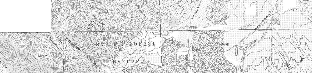
6 I. INTRODUCTION This report presents a restoration plan for wetland impacts associated with repairing a bridge crossing and drainage facility on Squaw Mountain Road. Based on meetings and correspondences, restoration proposed in this plan is anticipated to fulfill mitigation requirements of several resource agencies, including the U.S. Army Corps of Engineers (USACE; permit pending), Regional Water Quality Control Board (RWQCB; permit pending), and California Department of Fish and Wildlife (CDFW; permit pending), and fulfill the project s obligation under the California Environmental Quality Act (CEQA). The goal of the overall bridge repair effort is to repair Squaw Mountain Road Bridge at Coldwater Wash, as well as associated erosion of the drainage both up and downstream of the bridge. All temporary impacts associated with the bridge and drainage repair will be restored to pre-existing conditions. The restored habitat is expected to approach the function and services of early successional habitat within 5 years. This plan addresses the all mitigation associated with the bridge and drainage repair. Nomenclature used in this report follows Oberbauer (2008) for vegetation communities, Rebman and Simpson (2006) for plants, American Ornithologists Union (2009) for birds, and Baker et. al. (2003) for mammals. A. PROJECT LOCATION II. PROJECT SUMMARY The Squaw Mountain Road Bridge is located in southwestern Riverside County, just south of the City of Corona, California. The project site is located in Temescal Canyon adjacent to Interstate 15 (Figure 1). The project site is located in Sections 2 and 3, Township 5 South, Range 6 West on the U.S. Geological Service Lake Matthews quadrangle (Figure 2), parcel numbers and The project site consists of the Squaw Mountain Road bridge where it crosses Coldwater Wash and an adjacent small tributary; the closest cross street is Temescal Canyon Road (Figures 3 and 4). The center of the project site is located at Latitude 33 46'6.575" N, Longitude '9.924" West. The bridge was originally constructed as part of the Painted Hills Residential Development project. The RWQCB issued a Waiver of Waste Discharge Requirements and Water Quality Certification for the overall project on February 9, Currently, the 0.92-acre project site contains extensive disturbance from the bridge failure to native wetland and upland habitats (mostly in the northern and southern portions of the site (Figure 5). The site also contains scattered non-native habitats. B. PROJECT DESCRIPTION The existing Squaw Mountain Road Bridge is failing and is in danger of washing away. The scouring at the bridge was discovered after a large storm in January The impending failure of the bridge poses an imminent threat to life and property, necessitating the repairs to the structure. The County of Riverside Department of Transportation concurs with this assessment. Wetland Mitigation Plan for Squaw Mountain Road Bridge Repair Project / KAB-157 / July 24,
7 The proposed repairs would consist of lining the channel bottom below the bridge with concrete, connecting the concrete-lined channel to the existing bridge abutments, placing ¼-ton riprap on the upstream and downstream sides of the concrete-lined portion of the channel (some of which will be buried by fill), and installing riprap slope protection on the northwest slope. As part of the repairs, an existing asphalt access road would be extended approximately 40 feet. There is also a side tributary to Coldwater Wash that was realigned as part of the original Painted Hills Residential Development project and was intended to flow adjacent to Squaw Mountain Road before entering the wash. As a result of significant degradation of the channel wash, the side channel has head cut back from the wash and is now eroding into the slope of Squaw Mountain Road and needs to be stabilized. The proposed repairs would consist of regrading the upper portion of the channel to the appropriate elevation, leaving this portion of the channel as a natural drainage. Flows will then be picked up in a basin before entering into a pipe that will outlet at the base of the slope in Coldwater Wash. The proposed project has been designed to avoid as much of the extant riparian vegetation as possible while still providing a hydraulically stable channel over the long term. Permanent impacts to jurisdictional areas will result from the installation of concrete lining below the bridge, connecting the concrete-lined channel to the existing bridge abutments, placing ¼-ton riprap on the upstream and downstream sides of the concrete lined portion of the channel, and installing riprap slope protection on the northwest slope. Permanent impacts associated with the project total approximately 0.41 acre and include 0.04 acre of mule fat scrub (MFS), less than 0.01 acre of Riversidean alluvial fan sage scrub (RAFSS), 0.03 acre of southern willow scrub (SWS), 0.14 acre upland habitat, and 0.20 acre of streambed. Temporary impacts total 0.51 acre and are comprised of 0.16 acre of MFS, 0.02 acre of RAFSS, 0.13 acre of SWS, 0.01 acre tamarisk scrub (TS), 0.13 acre of streambed, and 0.06 acre upland habitat. C. JURISDICTIONAL IMPACTS The USACE jurisdictional impacts would total 0.35 acre consisting entirely of non-wetland Waters of the U.S. (WUS; 0.14 acre of permanent impacts and 0.21 acre of temporary impacts; Table 1, Figure 5). Other wetland resources occurring on site would be avoided. The CDFW jurisdictional impacts total 0.72 acre and consist of permanent impacts to 0.27 acre of Waters of the State (WST) and temporary impacts to 0.45 acre of WST (Table 1; Figure 6). The CDFW jurisdictional areas to be impacted consist of 0.20 acre MFS, 0.02 acre of RAFSS, 0.16 acre of SWS, 0.01 acre tamarisk scrub, and 0.33 acre of streambed. Wetland Mitigation Plan for Squaw Mountain Road Bridge Repair Project / KAB-157 / July 24,
8 ?q Riverside SAN BERNARDINO COUNTY RIVERSIDE COUNTY I:\PROJECTS\K\KAB\KAB-157_PaintedHills\Map\BIO\RestorationPlan\Fig1_Regional.mxd KAB /11/13 -EV Corona!"a$ Norco A»!"a$! Project Site Lake Elsinore ORANGE COUNTY RIVERSIDE COUNTY Lake Mathews Lake Elsinore %&h( A!"a$ Moreno Valley Murrieta Perris Lake Perris %&h( A Aª?q Temecula Aª San Jacinto Aª Hemet Diamond Valley Lake Lake Skinner!"a$ Aª Banning Beaumont Vail Lake AÀ!"`$ AÚ Hemet Lake A?u Desert Hot Springs Palm Springs RIVERSIDE COUNTY SAN DIEGO COUNTY AÌ Palm Desert Lake Cahuilla A A³ Coachella Aw A³ AÌ Salton Sea Regional Location Map SQUAW MOUNTAIN ROAD N 0 10 Miles Figure 1

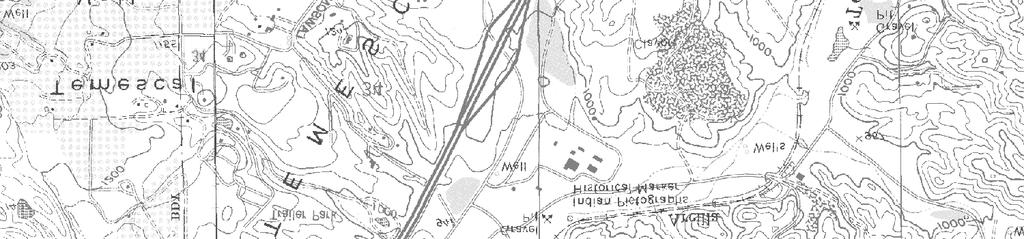

9 Project Impacts I:\PROJECTS\K\KAB\KAB-157_PaintedHills\Map\BIO\RestorationPlan\Fig2_Location.mxd KAB /17/13 -EV Source: USGS 7.5' Quadrangle; Lake Mathews Project Location Map SQUAW MOUNTAIN ROAD N 0 2,000 Feet Figure 2


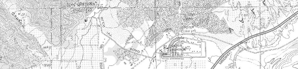
10 Park Canyon Drive Knabe Road Montecito Ranch Park $ a "! Project Impacts ay rkw y Pa g o l i Tr KAB /17/13 -EV Golf Club at Glen Ivy I:\PROJECTS\K\KAB\KAB-157_PaintedHills\Map\BIO\RestorationPlan\Fig3_Aerial_Regional.mxd c Temes yo n R al C an o ad Aerial Photograph SQUAW MOUNTAIN ROAD N 0 2,000 Feet Figure 3


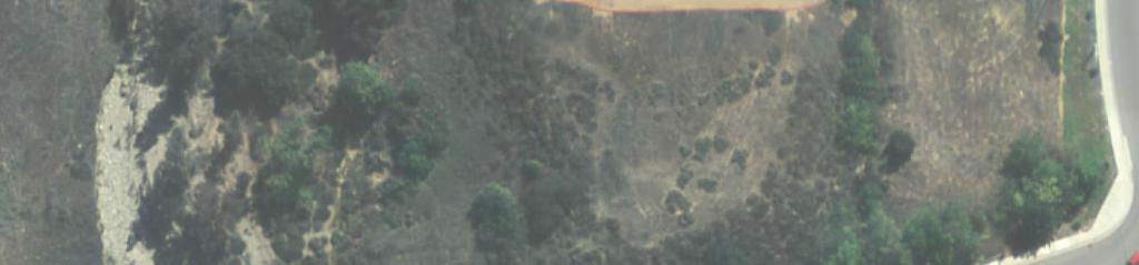
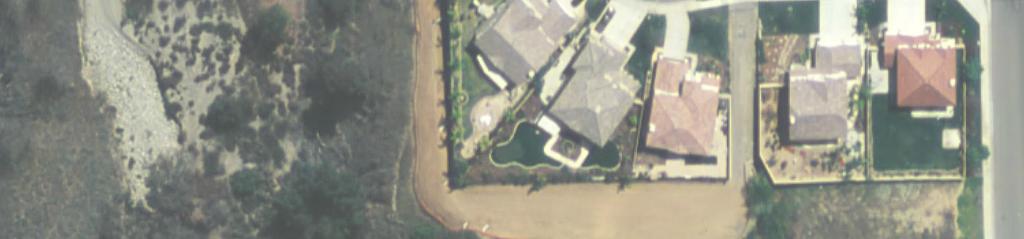
11 Permanent Impact Temporary Impact Squaw Mountain Road I:\PROJECTS\K\KAB\KAB-157_PaintedHills\Map\BIO\RestorationPlan\Fig4_Aerial.mxd KAB /11/13 -EV Aerial Photograph N Feet SQUAW MOUNTAIN ROAD Figure 4


12 !!!!!!!!!!!!!!!! Permanent Impact Temporary Impact Non-wetland Waters of the U.S. :Non-wetland Waters of the U.S. (width shown in feet)! 5' 5' : : 2' :! 1' : : 2' : 1' 2' :! Squaw Mountain Road! : I:\PROJECTS\K\KAB\KAB-157_PaintedHills\Map\BIO\RestorationPlan\Fig5_USACE_Impacts.mxd KAB /11/13 -EV 3' : : 1'! : 5' 6' : 4' : 3' : 1'!!! : 1' USACE Impacts N Feet SQUAW MOUNTAIN ROAD Figure 5


 Squaw")


13 Permanent Impact Temporary Impact Southern Riparian Woodland Southern Willow Scrub Mule Fat Scrub Coast Live Oak Woodland Streambed Riversidean Alluvial Fan Sage Scrub Tamarisk Scrub Eucalyptus Woodland (Streambed) Squaw Mountain Road I:\PROJECTS\K\KAB\KAB-157_PaintedHills\Map\BIO\RestorationPlan\Fig6_CDFW_Impacts.mxd KAB /11/13 -EV CDFW Impacts N Feet SQUAW MOUNTAIN ROAD Figure 6
14 Table 1 SQUAW MOUNTAIN ROAD RESTORATION PROJECT USACE/CDFW JURISDICTIONAL IMPACTS (Acre) HABITAT USACE CDFW* Permanent Temporary TOTAL Permanent Temporary TOTAL Mule fat scrub Riversidean alluvial fan sage scrub < Southern willow scrub Streambed Tamarisk scrub TOTAL *CDFW jurisdictional impacts include USACE impacted areas. D. MITIGATION REQUIREMENTS Pursuant to Section 404 of the federal Clean Water Act, the USACE regulates the discharge of fill material into WUS. and evaluates the impacts of the placement of proposed fill into such waters. Under Section 401 of the federal Clean Water Act, the RWQCB also has authority over USACE jurisdictional areas. To ensure no-net-loss of jurisdictional areas, as well as associated functions and services, the USACE requires compensatory mitigation for jurisdictional impacts. Jurisdictional impacts and mitigation can be assessed by mapping vegetation and delineating the USACE wetlands as specified in their current manuals (Environmental Laboratory 1987 and USACE 2008a). The CDFW regulates impacts to wetland habitats pursuant to Section 1602 of California Fish and Game Code. The project proponent has submitted permit applications to the USACE under Section 404 of the federal Clean Water Act, to the CDFW under Section 1600 of the California Fish and Game Code, and to the RWQCB under section 401 of the federal Clean Water Act for impacts to jurisdictional areas. Proposed mitigation for temporary impacts to 0.45 acre of WUS and WST would be accomplished through on-site restoration of 0.45 acres (Table 2) while mitigation for permanent impacts to 0.27 acre would be accomplished by participation in the Riverside-Corona Resource Conservation District (RCRCD) In Lieu Fee program. Final mitigation requirements will be established through consultation with the regulatory agencies. Wetland Mitigation Plan for Squaw Mountain Road Bridge Repair Project / KAB-157 / July 24,
15 Table 2 SQUAW MOUNTAIN ROAD BRIDGE RESTORATION PROJECT USACE/CDFW MITIGATION SUMMARY FOR TEMPORARY IMPACTS USACE CDFW 1 HABITAT Impact Mitigation 2 Impact Mitigation 2 (acre) Ratio Acre(s) (acre) Ratio Acre(s) Mule fat scrub : Southern willow scrub : Riversidean alluvial san sage scrub : Streambed : : Tamarisk scrub : TOTAL Includes USACE areas 2 Mitigation to occur as on-site restoration of temporary disturbance areas. III. MITIGATION SITE DESCRIPTION This report addresses the on-site restoration of all temporary impacts associated with the repair of the Squaw Mountain Road bridge and associated drainage. A. MITIGATION LOCATION All mitigation for temporary impacts will occur on-site, in place (Figure 7). Upland mitigation will occur where upland habitat occurs prior to repairs while riparian scrub habitat will be restored where wetland vegetation and/or streambed currently occur. B. ENVIRONMENTAL SETTING The site is located along Coldwater Wash along a riparian corridor that stretches both up- and down-stream of Squaw Mountain Road. The main drainage (Coldwater Wash) runs north to south with a tributary drainage located to the east of the wash just south of Squaw Mountain Road. The tributary was realigned as part of the original development project and was intended to flow adjacent to Squaw Mountain Road before entering the wash. South of the bridge riverine habitat extends the width of the channel for about 50 feet and then narrows to a 20-foot wide strip along the west side of the channel. Elevations on site range between 1117 feet above mean sea level along the creek to 1042 feet above mean sea level. The bridge and drainage repair site currently contains 4 wetland vegetation communities: SWS, MFS, RAFSS, and streambed as well as a small amount of non-native TS (Figure 6). In addition, the repair site contains a small amount of native upland habitat. Soils on site include Arbuckle gravelly loam (8 to 15 percent slopes), Cortina gravelly loamy sand (2 to 8 percent slopes), Arbuckle gravelly loam (2 to 8 percent slopes), and Terrace escarpments. Wetland Mitigation Plan for Squaw Mountain Road Bridge Repair Project / KAB-157 / July 24,
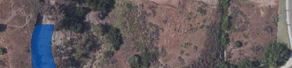
16 Riparian Scrub Restoration Southern Willow Scrub Restoration Upland Restoration I:\PROJECTS\K\KAB\KAB-157_PaintedHills\Map\BIO\RestorationPlan\Fig7_On-siteRestoration.mxd KAB /23/13 -DR Squ aw M ou n ta in Roa d On-site Restoration SQUAW MOUNTAIN ROAD N Feet Figure 7
17 C. EXISTING FUNCTIONS AND SERVICES Wetland restoration is proposed to occur along the portions of Coldwater Wash that have been damaged by erosion and scouring and that would need to be temporarily impacted to implement bridge and drainage repairs. This section provides a brief overview of the functions and services currently provided by the proposed mitigation area based on a review of site maps and site visits to document pre-existing conditions. This information will be used for comparison with post-restoration annual assessments to measure the change in the system as a result of wetland habitat restoration. 1. Vegetation The portion of the channel that is proposed for bridge and drainage repair currently contains jurisdictional areas comprised of native wetland habitat types including MFS, RAFSS, SWS, and non-native TS. Vegetation is sparse and open and there is also a substantial amount of unvegetated streambed. Typical plant species within this channel include native plants such as mule fat (Baccharis salicifolia), willows (Salix spp.), and mugwort (Artemisia douglasiana), and a minimal amount of non-native plants including tamarisk. In addition to wetlands, a small amount of native upland habitat would be impacted. 2. Hydrology Coldwater Wash currently contains wetland hydrology along the bottom of the channel. The portion of the channel that is proposed for restoration currently provides various levels of wetland functions and services for groundwater recharge, nutrient removal, flood buffering, and sediment stabilization. 3. Wildlife Existing wildlife functions and services are reduced because of the erosional damage and channel scouring within the proposed mitigation area. Although currently disturbed, this area retains at least moderate functions and services for wildlife since it is contiguous with intact native wetland and upland habitats both up- and down-stream of the bridge that support a diverse assemblage of plant and animal species. D. MITIGATION SITE SUITABILITY The proposed mitigation area is considered suitable for wetland habitat restoration due to the location of the site along an existing riparian corridor, and the presence of existing riparian habitat within the project area and both up- and downstream of the mitigation area. After repairs to the bridge and drainage are completed, native seed and container stock will be installed in temporarily disturbed areas. Wetland restoration is expected to be successful because this activity would occur in areas that currently support, or recently supported riparian habitat but need to be temporarily impacted to successfully repair the bridge and erosional portions of the drainage. Because the restoration areas will be graded to the appropriate elevation for wetland Wetland Mitigation Plan for Squaw Mountain Road Bridge Repair Project / KAB-157 / July 24,
18 hydrology, and occur interspersed within existing riparian habitat, restoration efforts are expected to have a high degree of success. IV. MITIGATION DESIGN CONCEPT To meet USACE, CDFW, and RWQCB (hereafter referred to as resource agencies ) mitigation requirements, as appropriate, this plan recommends measures to restore open riparian scrub and associated upland habitat in temporarily impacted areas along Coldwater Wash. It is anticipated that the functions and services of wetland habitat along the temporarily disturbed portions of the channel will be restored with the proposed mitigation measures. A. MITIGATION DESIGN The proposed mitigation was designed to minimize impacts to the existing on-site native habitat. Temporarily impacted areas will be re-graded to appropriate wetland and upland elevations as part of the bridge and drainage repair activities. Following the completion of all grading, irrigation, plantings and seed will be installed such that a similar, open riparian scrub habitat to that occurring before bridge and drainage repair work was conducted can be restored. To most closely resemble the vegetation present prior to impacts, Coldwater Wash would be restored with 0.33 acre of open riparian scrub habitat while the tributary drainage would be restored with 0.12 acre of open southern willow scrub habitat. To resemble natural conditions, a significant amount of unvegetated streambed is expected to be established within these restored wetlands. A small amount of upland restoration (0.06 acre) will occur along the margins of the restored wetlands (Figure 7). Best Management Practices (BMP s) such as gravel bags, fiber rolls, mulching, and silt fencing will be installed as needed around the restoration perimeter. B. TARGET FUNCTIONS AND SERVICES To fulfill resource agencies mitigation requirements, the overall goal of this mitigation effort is to at least replace jurisdictional acreage and related aquatic functions and services of open riparian habitat that will be impacted as part of the bridge and drainage repair effort. With the restoration of the wetland channel, it is expected that functions and services (flood control, water filtration, wildlife habitat, etc.) that are currently being performed by the wetlands within the channel would be restored by the end of the Year 5 mitigation effort. C. RATIONALE FOR EXPECTING IMPLEMENTATION SUCCESS Wetland habitat restoration is anticipated to be successful due to its location along an existing creek, with intact native wetland/riparian habitat located both up- and downstream. Although the target area has been degraded by a previous erosion, the following measures will assist with the establishment of healthy wetland habitat: (1) the site will be graded to the same elevation as existing, adjacent wetland habitat (or within 12 to 24 inches of the groundwater table); (2) tree and shrub cuttings will be collected from the areas that will be impacted, to be used within the restoration area to the maximum extent practicable; (3) the planting and seed palette has been Wetland Mitigation Plan for Squaw Mountain Road Bridge Repair Project / KAB-157 / July 24,
19 based on species observed in existing on-site wetland habitat or other similar habitat in the project vicinity; and (4) temporary irrigation will be used to aid in plant establishment. A. PROJECT PROPONENT V. PROJECT RESPONSIBILITY KB Home is Lead Agency for this project. Contact information is provided below. KB Home Contact: Mr. Mike Freeman Inland Valley Drive Wildomar, CA (951) B. RESTORATION SPECIALIST Overall supervision of the installation, maintenance, and monitoring of this mitigation project will be the responsibility of a restoration specialist with experience in wetland habitat restoration. The restoration specialist will oversee the efforts of the landscape contractor(s) for the life of the project. Specific tasks of the restoration specialist include educating all participants with regard to mitigation goals and requirements; directly overseeing grading, planting, seeding, weeding, and maintenance; and coordinating annual assessments, including plant and avian surveys. The restoration specialist will ensure that the contractor does not inadvertently impact sensitive habitat areas (and sensitive species). When necessary, the restoration specialist will provide the project proponent and contractor with a written monitoring memo, including a list of items in need of attention. The restoration specialist will prepare and submit required reports to the project proponent(s) and resource agencies each year. C. LANDSCAPE ARCHITECT A licensed landscape architect will prepare the necessary construction documents, including grading, irrigation, and planting plans, and will provide the draft landscape plans to the agencies for review and approval prior to initiating construction. This person will inspect the irrigation system and assist in other inspections (e.g., plant deliveries), as necessary. D. INSTALLATION/MAINTENANCE CONTRACTOR The installation contractor will have wetland habitat restoration experience and be responsible for irrigation installation, pre-planting weed control, and planting and seeding. The restoration specialist will supervise the contractor regarding the installation of wetland plants. After the installation contract is completed, the project proponent(s) will hire a maintenance contractor for the duration of the 5-year minimum monitoring period. The maintenance Wetland Mitigation Plan for Squaw Mountain Road Bridge Repair Project / KAB-157 / July 24,
20 contractor and the installation contractor may be the same entity. The project proponent may change contractors at its discretion. The maintenance contractor will have prior knowledge regarding the maintenance of native wetland habitat and be familiar with native and non-native plants. The maintenance contractor will service the entire mitigation area according to the maintenance schedule (Section VII.B, below). Service will include but not be limited to weed control, irrigation maintenance, trash removal, watering, dead plant replacement, and re-seeding. All activities conducted will be seasonally appropriate and approved by the restoration specialist. The maintenance contractor will meet the restoration specialist at the site when requested and will perform all checklist items in a timely manner as directed. VI. MITIGATION INSTALLATION A summary of all major tasks related to the project, starting with the pre-construction phase and ending with the end of the minimum 5-year maintenance and monitoring period, is provided in Table 3. A. INSTALLATION SCHEDULE Installation will begin immediately following completion of repair work and final grading activities. B. PLANT/SEED ORDERS The plant species selected for installation in this mitigation site have been documented to occur on site (LSA 2000) or are common in the region and known from this watershed. All plants and seed installed at the site will be propagated from on site or nearby sources, unless otherwise authorized by the restoration specialist. The collected seed will be labeled and stored in a cool, dry location until it is used at the mitigation site. The restoration specialist must approve all seed and container stock orders, including specific species and source locations, prior to finalizing. C. PRE-CONSTRUCTION MEETING Prior to initiation of restoration activities, an on-site meeting will be held with the project proponent, grading contractor (as part of the repair activities), installation contractor, and restoration specialist. Topics that will be addressed at this meeting include but are not limited to: (1) identification of sensitive areas and a strategy for avoidance, (2) defining site access routes and restrictions, (3) locating staging areas, and (4) the overall project goal. D. DELINEATING LIMITS OF WORK The outer limits of the mitigation area will be delineated by the extent of bridge and drainage repair activities. To protect existing riparian habitat from potential construction and erosion impacts, silt fencing and/or other erosion control measures would be installed along the periphery. Wetland Mitigation Plan for Squaw Mountain Road Bridge Repair Project / KAB-157 / July 24,
21 CONSTRUCTION PHASE Pre-Construction RESTORATION TASK Table 3 RESTORATION PLAN CHECKLIST Project Proponent 1 Landscape Architect APPLICABLE PARTIES Installation Contractor Maintenance Contractor Restoration Specialist Order container plantings and seed 2 X Prepare Landscape Plans X X X* Attend pre-construction meeting X X X Install erosion control to protect existing habitat X* Document pre-installation site conditions X Grading inspection (grading would be part of the bridge and drainage repair work) X Installation Install irrigation X X* Inspect irrigation X X Install container plantings, cuttings, and seed X X* Non-native plant removal X X* Document as-built conditions X Prepare/submit as-built report X 120-day Establishment Period Maintain site for 120 days, or until sign off X X* X* by the restoration specialist Replace dead container plantings, as needed X X* 5-year Maintenance & Monitoring Period Maintain site for minimum of 5 years until sign off by resource agencies 1 KB Home 2 Must provide all source locations and receive authorization of final seed and plant lists prior to ordering * Inspecting work related to this task Resource Agencies X X* X* Wetland Mitigation Plan for Squaw Mountain Road Bridge Repair Project / KAB-157 / July 24,
22 THIS PAGE INTENTIONALLY LEFT BLANK Wetland Mitigation Plan for Squaw Mountain Road Bridge Repair Project / KAB-157 / July 24,
23 E. IRRIGATION Temporary, above-ground irrigation will be installed throughout the restoration area. The irrigation plans will be submitted to the USACE for review and approval prior to implementation. The project landscape architect, together with the installation contractor, will inspect the irrigation to ensure full coverage of target areas prior to plant/seed installation. Irrigation will be removed prior to signoff of the restoration effort by the resource agencies. F. PLANT/SEED INSTALLATION Container stock, cuttings, and seed from a variety of plants occurring in riparian habitats found on-site will be installed within restoration areas (Tables 4, 5, and 6; Figure 7). The restoration specialist must inspect all plant material prior to installation. Scientific Name Table 4 OPEN RIPARIAN SCRUB PLANTING PALETTE (0.33 acre) CONTAINER PLANTINGS* Spacing on Center (feet) Common Name Grouping Size Number Per Acre Quantity Required Artemisia douglasiana mugwort Baccharis salicifolia mule fat Baccharis emoryi Emory s baccharis Sambucus mexicana blue elderberry TOTAL SEED MIXTURE Scientific Name Common Name % Purity / Lbs. Lbs./Acre Germin. Required Ambrosia psilostachya western ragweed 20/ Artemisia douglasiana mugwort 15/ Baccharis salicifolia mule fat 10/ Isocoma menziesii goldenbush 40/ TOTAL *All plantings will be in 1-gallon sized containers. Wetland Mitigation Plan for Squaw Mountain Road Bridge Repair Project / KAB-157 / July 24,
24 Scientific Name Table 5 OPEN SOUTHERN WILLOW SCRUB PLANTING PALETTE (0.12 acre) CONTAINER PLANTINGS* Spacing on Center (feet) Common Name Grouping Size Number Per Acre Quantity Required Baccharis salicifolia mule fat Salix lasiolepis arroyo willow Salix gooddingii black willow Salix laevigata red willow TOTAL 1, CUTTINGS Scientific Name Common Name Spacing Grouping Number Quantity on Center Size Per Acre Required (feet) Baccharis salicifolia mule fat Salix lasiolepis arroyo willow Salix gooddingii black willow Salix laevigata red willow TOTAL SEED MIXTURE Scientific Name Common Name % Purity / Lbs./ Lbs. Germin. Acre Required Ambrosia psilostachya western ragweed 20/ Artemisia douglasiana mugwort 15/ Baccharis salicifolia mule fat 10/ TOTAL *All plantings will be in 1-gallon sized containers. Scientific Name Table 6 UPLAND PLANTING PALETTE (0.06 acre) CONTAINER PLANTINGS* Spacing Grouping Common Name on Center Size (feet) Number Per Acre Quantity Required Artemisia californica California sagebrush Eriogonum fasciculatum California buckwheat Encelia farinosa brittle bush Wetland Mitigation Plan for Squaw Mountain Road Bridge Repair Project / KAB-157 / July 24,
25 Table 6 (cont.) UPLAND PLANTING PALETTE (0.06 acre) CONTAINER PLANTINGS* (cont.) Ericameria pinifolia pine-bush Salvia apiana white sage Atriplex canescens four-wing saltbush TOTAL 1, SEED MIXTURE Scientific Name Common Name % Purity / Lbs./ Lbs. Germin. Acre Required Eriogonum fasciculatum California buckwheat 50/ Encelia farinosa brittle bush 50/ Artemisia californica California sagebrush 15/ Salvia apiana white sage 70/ Corethrogyne filaginifolia cudweed aster 15/ Deinandra fasciculata fascicled tarplant 20/ Eriophyllum confertiflorum golden yarrow 70/ TOTAL *All plantings will be in 1-gallon sized containers. G. DOCUMENT POST-RESTORATION CONDITIONS Following installation completion, the restoration specialist will assess and photograph the restoration area to document the baseline condition of the channel. Results from this assessment will be used over the course of the 5-year monitoring effort to determine whether post-restoration functions and services improved as a result of the restoration effort. H. AS-BUILT CONDITIONS The restoration specialist shall submit a brief as-built letter report to the resource agencies within 30 days of completion of restoration activities and the 120-day establishment period. The report will describe restoration site preparation, installation methods, activities conducted during the 120-day establishment period, and the as-built status of the site. To document implementation of the restoration plan and baseline site conditions, the letter will include an as-built graphic on an aerial photo base as well as photos taken from the designated photo stations before and after restoration installation. The as-built letter will serve as the time zero report, noting when the 5-year maintenance and monitoring period began. Wetland Mitigation Plan for Squaw Mountain Road Bridge Repair Project / KAB-157 / July 24,
26 A. MAINTENANCE ACTIVITIES VII. MAINTENANCE PLAN These maintenance guidelines are specifically tailored for native plant establishment. A minimum 5-year maintenance program is proposed to ensure the successful establishment and persistence of the restored wetland habitat within 0.45-acre project temporary impacts. The maintenance program will include removal of trash, weed control, irrigation system maintenance, irrigation application rates and schedules, and any remedial measures deemed necessary for the success of the restoration program (e.g., re-seeding and re-planting). Maintenance activities will be directed by the restoration specialist. 1. General Maintenance It is the contractor s responsibility to keep all planted areas free of debris, monitor irrigation function and scheduling, monitor plant material condition and health, and conduct weeding and erosion control. Maintenance personnel will be fully informed of the habitat creation program so that they understand the effort s goals and maintenance requirements. A professional with experience in and knowledge of native habitat restoration will supervise all maintenance activities. Damage to plants, irrigation systems, and other facilities occurring as a result of unusual weather or vandalism will be repaired, as directed by the restoration specialist. The cost of such repairs will be paid for as extra work. The contractor will repair any damage caused by the contractor s inadequate maintenance or operation of irrigation facilities, as determined by the restoration specialist. 2. Non-native Plant Removal Particular emphasis will be placed on pro-active removal of non-native plants. During the first 3 years of the program, eradication is expected to be necessary on a monthly basis between November and April (to cover the peak growing period for most plants) and 2 additional visits for the remainder of the year. For years 4 and 5 of the monitoring program, maintenance visits may be reduced to quarterly if approved by the restoration specialist. Non-native plants should be removed by hand or controlled with the proper herbicides. Maintenance personnel should be knowledgeable in distinguishing between native and non-native species; however, additional guidance will be provided, as needed, by the restoration specialist. 3. Invasive Plant Control Non-native species considered to by highly invasive by the California Invasive Plant Council (Cal-IPC) shall be totally eradicated within restoration boundaries. Examples of invasive plants that occur on site include, but are not limited to, are castor bean and tamarisk. These species would be removed from the entire wetland mitigation area. Wetland Mitigation Plan for Squaw Mountain Road Bridge Repair Project / KAB-157 / July 24,
27 4. Irrigation The goal is to obtain germination and growth with the least amount of irrigation. Frequent irrigation encourages weed invasion and leaches nutrients from the soil; therefore, water will be applied infrequently and only as needed to prevent plant and seedling mortality. Native plantings that are infrequently irrigated may grow slower initially but will ultimately be better able to withstand natural variations in rainfall and, therefore, be more successful in the long term. The irrigation schedule will attempt to develop deep-root growth with evenly spaced, infrequent, deep applications of water. To obtain deep penetration of water, the irrigation system may be activated several times in one 24-hour period. Irrigation will be minimized to the extent possible following natural rainfall events. The irrigation system will be maintained until the restoration specialist determines that supplemental water is no longer required. At that time, irrigation will be permanently disconnected (e.g., the mainline will be cut), but not removed. Above-ground portions of irrigation will be removed when directed by the restoration specialist. 5. Other Pests Insects, vertebrate pests, and diseases will be monitored. Generally, there will be a high threshold of tolerance before control measures are considered. As required by law, specific recommendations will be made only by a licensed pest control adviser. All applicable federal and state laws and regulations will be closely followed. The restoration specialist will be consulted on any pest control matters. 6. Fertilization Fertilizer will not be applied except in extraordinary circumstances and only at the written direction of the restoration specialist. 7. Pruning No post-installation pruning is necessary unless otherwise directed by the restoration specialist. B. MAINTENANCE SCHEDULE Maintenance will be performed as necessary to prevent re-seeding by non-native plants and will likely change with varying site conditions and seasons; the schedule outlined herein (Table 7) serves only as a guideline. At a minimum, the installation contractor will conduct monthly maintenance during the 120-day establishment period until the restoration specialist recommends sign off of the 120-day establishment period in writing. The maintenance contractor will be responsible for all maintenance activities during the minimum 5-year maintenance and monitoring period. For the first 3 years of the 5-year maintenance and monitoring period, maintenance is expected to be required once per month between January and June (to cover the peak growing period for most plants) and 2 additional visits for the remainder of the year. Maintenance visits may be reduced and become quarterly in Years 4 and 5 if approved by the Wetland Mitigation Plan for Squaw Mountain Road Bridge Repair Project / KAB-157 / July 24,
28 restoration specialist. The installation/maintenance contractor(s) will complete maintenance requests from the restoration specialist within 14 days of any written request or monitoring report. Table 7 MAINTENANCE SCHEDULE FOR THE 5-YEAR RESTORATION PERIOD* TIME FRAME SCHEDULE Installation Contractor 120-day Establishment Period Monthly Maintenance Contractor Year 1 through Year 3 8 visits per year January June Monthly July December August and October Years 4 and 5 Quarterly *This schedule is only a guideline; maintenance will be performed as necessary and as directed by the restoration specialist. VIII. MONITORING PLAN Monitoring and annual assessments will be carried out under direction of the restoration specialist. This monitoring program will begin with habitat installation and continue for a minimum of 5 years following the end of the 120-day establishment period. Monitoring of the restoration effort is divided into 5 phases: (1) pre-installation data collection, (2) installation monitoring, (3) post-installation data collection, (4) maintenance monitoring, and (5) annual technical monitoring. Details of each phase are provided in this section of the mitigation plan. A. PRE-INSTALLATION DOCUMENTATION Prior to initiating construction activities, existing functions and services will be assessed in the area where restoration will be conducted. This includes conducting the following: (1) photographing pre-impact conditions at a minimum of 3 photo locations, (2) visually estimating vegetation cover, and (3) compiling a list of all animals observed or detected (by hearing vocalizations or seeing scat, tracks, or burrows) during the course of the assessment. The photo locations will be mapped using a Global Positioning System (GPS) for future comparison with post-restoration conditions. Pre-impact data collected will be used to assess project success in years 3 and 5. Wetland Mitigation Plan for Squaw Mountain Road Bridge Repair Project / KAB-157 / July 24,
29 B. INSTALLATION MONITORING A restoration specialist will monitor all phases of the installation process, including site preparation (non-native plant removal) and installation of irrigation, plants, and seed (Table 8). The restoration specialist must inspect and authorize each phase of work before the next phase may begin. Pre-installation photos will be taken from designated photo documentation stations. This information will be used later to track the changes in vegetation as a result of site restoration. Table 8 MONITORING SCHEDULE* PHASE Installation Period Site preparation and installation 5-year Restoration Period 120-day establishment period Year 1 through 3 January to June July to December Years 4 and 5 SCHEDULE As needed, to be determined by the restoration specialist, but at least 4 times: Post project grading Post irrigation installation First day of plant installation After all installation is completed Monthly 8 visits per year Monthly August and October Quarterly *This schedule is only a guideline; monitoring will be performed as necessary, as determined by the restoration specialist. C. POST-INSTALLATION DOCUMENTATION Following restoration installation, a restoration specialist will assess the area and document its status by taking photos from the established photo locations. D. MAINTENANCE MONITORING Following installation, the restoration specialist will monitor maintenance activities during the minimum 5-year restoration effort (Table 8), beginning immediately following the 120-day establishment period. For Years 1 through Year 3, monitoring visits will be conducted monthly from January through June, which corresponds with the growing season for wetland vegetation, and 2 other times during the remainder of the year. In Years 4 and 5, monitoring will be conducted 6 times per year. This monitoring schedule is the minimum; more frequent inspections may be necessary if there are problems with contractor performance or habitat Wetland Mitigation Plan for Squaw Mountain Road Bridge Repair Project / KAB-157 / July 24,
30 development. Monitoring memos noting any issues with plant establishment, irrigation, sediment control, etc., will be provided as necessary to the installation/maintenance contractor(s) and project proponent(s). E. ANNUAL TECHNICAL MONITORING In addition to maintenance monitoring visits, the restoration specialist will conduct an annual technical monitoring visit in August of each year during the 5-year restoration period. The timing of this assessment should correspond with the peak of the wetland vegetation growth for that year. Monitoring methods are described in more detail below. 1. Photo Documentation Photos will be taken as part of all 5 annual monitoring events and will be included in the respective year s annual report. Photos will be taken at the same photo locations that are established prior to the start of the restoration effort. To visually demonstrate the progress of the restoration effort, photos taken immediately after restoration installation will be included in each report for comparison with the respective year s annual assessment photos. The photo locations will be permanently marked in the field and then mapped on an aerial photograph in the baseline monitoring report (as-built report following the 120-day establishment period) and all subsequent annual reports. 2. Visual Estimates Visual estimates will be documented for container planting survivorship, cover by native and non-native plants, and average height of tree and shrub species. 3. General Wildlife During each of the 5 annual assessments (and as part of the regular maintenance monitoring events), a complete list of all wildlife incidentally observed or detected will be documented for the restoration area. 4. Annual Reports An annual report will be prepared each year during the 5-year monitoring period. Each of the 5 annual reports will be based on qualitative assessment data and focus on what (if any) adjustments are necessary to ensure ultimate success of the mitigation project. Each report will evaluate the success of the mitigation effort to date, along with any recommendations for future work that may be deemed necessary. Baseline post-restoration photos, as well as photos from the respective annual assessment, will be included in the annual reports, which will be submitted to the resource agencies in a timely manner. Wetland Mitigation Plan for Squaw Mountain Road Bridge Repair Project / KAB-157 / July 24,
31 IX. SUCCESS CRITERIA The following sections provide standards to determine the successful completion of the wetland restoration effort as well as measurement methods for success criteria. Attainment of these standards indicates that the restoration area is progressing toward attaining the habitat function and services targeted by this plan. A. 120-DAY ESTABLISHMENT PERIOD Success at the end of the 120-day establishment period will be met if non-native cover is less than 10 percent at the time of the inspection, there is 80 percent survivorship of container stock, the irrigation system provides adequate cover, and there are no erosion-related issues. If any re-planting is conducted, container stock shall be in the ground for at least 30 days prior to the end of the establishment period. The minimum 5-year maintenance and monitoring period will begin immediately following this 120-day establishment period. B. ANNUAL ASSESSMENTS 1. General Wildlife No success criteria are specified for wildlife, but increasing use of the overall restoration area by species found at the impacted area would be a positive indicator that target wildlife functions and services have been restored at the site. 2. Vegetation Criteria Survivorship Target Container plantings should have at least 80 percent survival for the first 2 years. At the first and second anniversary of plant installation, container plantings should be added to the creation area if mortality exceeds 20 percent of the original plantings, unless the function of these plants has been replaced by native seed establishment (as determined by the restoration specialist). If plant mortality continues to be a problem, alternative measures (e.g., additional seeding or cuttings) should be considered. Native Cover Target Cover by native plants is a key component of determining project success. Annual performance goals relative to the estimated native cover and species richness existing within the proposed impact area have been established. Native cover and species richness goals are set lower than some restoration efforts due to the relatively large amount of unvegetated streambed and sparse, open nature of the vegetated portions of the existing wash and drainage. No specific cover criteria have been established for Years 1 or 2 because this is early in the development stage of the restoration area; however, cover will be assessed visually and if the vegetation is not on target to meet Year 3 goals, corrective measures (e.g., re-planting, re-seeding, adding cuttings, irrigation adjustments, and/or increasing removal of non-native species) should be implemented. Wetland Mitigation Plan for Squaw Mountain Road Bridge Repair Project / KAB-157 / July 24,
32 Starting in Year 3, the wetland restoration areas should attain at least 20 percent native cover (Table 9). At the end of the 5-year monitoring period, native cover will be at least 40 percent. If annual goals for vegetative cover are not met, remedial measures, including reseeding, planting, and increased weeding, may be implemented to ensure final success. YEAR Table 9 SUCCESS CRITERIA FOR RIPARIAN SCRUB AND SOUTHERN WILLOW SCRUB HABITAT RESTORATION PLANTING SURVIVORSHIP TARGET (percent) NATIVE COVER TARGET (percent) NON-NATIVE COVER LIMIT (percent) INVASIVE PLANT COVER LIMIT (percent) NATIVE SPECIES RICHNESS TARGET (species) Wetland Restoration Areas Non-native Cover Limit Non-native plants are typically a problem in habitat restoration projects, particularly at their outset. The areas designated for habitat restoration will be disturbed by grading, which favors the establishment of fast-germinating and fast-growing non-native annual species. As the restoration efforts take hold, non-native cover should decrease as a result of diligent removal of these species and expanding cover by native vegetation. In Years 1 through 3, cover by non-native species, exclusive of highly invasive species, shall account for no more than 10 percent within the restoration areas. In Years 4 and 5, cover shall not exceed 5 percent. Invasive Cover Limit A few Cal-IPC highly invasive plant species have been observed on site, including castor bean and tamarisk. The acceptable cover value for each of these species within the restoration areas will be 0 percent, which should then be maintained until the end of Year 5 (Table 9). Additional species may be added to this list if found to be a threat to the long-term success of the restoration effort. Native Species Richness The Year 5 goal is for the wetland restoration area to contain at least 3 native species. If interim species richness goals are not met, corrective measures (e.g., reseeding, planting, etc.) will be taken to help ensure eventual achievement of the 5-year goal. Wetland Mitigation Plan for Squaw Mountain Road Bridge Repair Project / KAB-157 / July 24,
Public Review Draft Oceanside Subarea Habitat Conservation Plan/ Natural Communities Conservation Plan
 Oceanside Subarea Habitat Conservation Plan/ Natural Communities Conservation Plan Prepared for City of Oceanside Planning Department 300 N. Coast Highway Oceanside, CA 92054 Prepared by Ogden Environmental
Stormwater Standards. Clackamas County Service District No. 1. Planting Guide for Buffers
 Stormwater Standards Clackamas County Service District No. 1 APPENDIX B Planting Guide for Buffers Table of Contents Appendix B - Planting Guide for Buffers... Page B.1 General... 1 B.1.1 Introduction...
las vegas wash coordination committee
 las vegas wash coordination committee lvwash.org DU Wetlands No. 1 Weir Planting Plan February 2013 DU Wetlands No. 1 Weir Planting Plan SOUTHERN NEVADA WATER AUTHORITY Las Vegas Wash Project Coordination
Section 3 Non-Structural BMPs
 3.1 Stream Buffers A stream buffer or stream setback is a designated area around a stream, lake, or wetland left in a natural, densely vegetated state so as to protect the receiving water quality and provide
Rule D Wetland and Creek Buffers
 Rule D Wetland and Creek Buffers 1 Policy It is the policy of the Board of Managers to ensure the preservation of the natural resources, recreational, habitat, water treatment and water storage functions
Chapter Six: Tree Removal and Erosion Control
 Chapter Six: Tree Removal and Erosion Control Through the combination of canopy and roots, trees help protect and stabilize the land. Their removal requires proper planning and adherence to land-based
ADDENDUM TO BIOLOGICAL SCOPING SURVEY REPORT, BOTANICAL SURVEY AND WETLAND DELINEATION
 ADDENDUM TO BIOLOGICAL SCOPING SURVEY REPORT, BOTANICAL SURVEY AND WETLAND DELINEATION FOR AVALON INN (APN 069-241-27 & -04) 1201 & 1211 NORTH MAIN STREET FORT BRAGG, CA MENDOCINO COUNTY prepared for:
Table of Contents TABLE OF CONTENTS SECTION TITLE PAGE
 TABLE OF CONTENTS SECTION TITLE PAGE 1 INTRODUCTION AND OVERVIEW 1-1 1.1 Purpose and Need 1-1 1.2 Goals and Objectives 1-3 1.3 Overview of the Planning Process 1-5 1.4 Federal and State Requirements and
ADOPTED CAPITAL IMPROVEMENT PROGRAM BUDGET ARROYO PROJECTS
 ADOPTED CAPITAL IMPROVEMENT PROGRAM BUDGET ARROYO PROJECTS HAHAMONGNA FY 212-216 Capital Improvement Program Priority Description Total Estimated Costs Appropriated Through FY 211 Adopted FY 212 FY 213
Draft Rhode Island Stormwater Design and Installation Standards Manual
 Draft Rhode Island Stormwater Design and Installation Standards Manual Summary The May 2009 Public Review Draft version of the RI Stormwater Design and Installation Standards Manual consists of approximately
APPENDIX C NATURAL RESOURCES MANAGEMENT PLAN: ACTIONS AND PRIORITIES
 APPENDIX C NATURAL RESOURCES MANAGEMENT PLAN: ACTIONS AND PRIORITIES TABLE C-1: Resource Actions and Priorities GOAL NRM-4 Objective 4.1: Restore Natural floodplain functions. Objective 4.2: Define and
Non-Metallic Mining Reclamation Checklist
 Eau Claire County DEPARTMENT OF PLANNING AND DEVELOPMENT Eau Claire County Courthouse, Rm. 1510 721 Oxford Avenue Eau Claire, Wisconsin 54703-5481 (715) 839-4741 f Housing & Community Development 839-6240
Plan Review Checklist
 Plan Review Checklist FOR EROSION AND SEDIMENT CONTROL PLANS _ Minimum Standards - All applicable Minimum Standards must be addressed. All minimum Standards must be adhered to during the entire project
STREAM BUFFERS
 88-415 STREAM BUFFERS 88-415-01 PURPOSE In the Kansas City region and throughout the nation, vegetated stream buffers have been clearly shown to protect stream stability and related infrastructure, improve
MANUAL OF DESIGN, INSTALLATION, AND MAINTENANCE REQUIREMENTS FOR STORMWATER MANAGEMENT PLANS
 MANUAL OF DESIGN, INSTALLATION, AND MAINTENANCE REQUIREMENTS FOR STORMWATER MANAGEMENT PLANS May 2007 SECTION 1 Responsibility of Applicant TABLE OF CONTENTS A. Stormwater Management Plan Required Information
Conservation Plan. I. Property Information. II. Objectives. Natural Resource Objectives. Sustainability in Practice (SIP) Certified
 Certified") Conservation Plan Sustainability in Practice (SIP) Certified I. Property Information Vineyard Name and Establishment Date: Location: Map (attach showing blocks and acres): II. Objectives Natural Resource
Conservation Plan Sustainability in Practice (SIP) Certified I. Property Information Vineyard Name and Establishment Date: Location: Map (attach showing blocks and acres): II. Objectives Natural Resource
Project: Developer/Designer: Reviewer: I. Narrative: 1. Project Description: Describes the nature and purpose of the land disturbing activity.
 City of Charlottesville, Virginia Erosion and Sediment Control Plan Review Checklist 610 East Market Street, Charlottesville, VA 22902 Telephone 434-970-3182; Fax 434-970-3359 Project: Developer/Designer:
NOTICE OF PREPARATION
 NOTICE OF PREPARATION DATE: January 6, 2016 TO: LEAD AGENCY: Responsible Agencies, Organizations, and Interested Parties Contact: Tyler Barrington, Principal Planner Planning Department Community Development
CHAPTER 2 SUMMARY 1. PROJECT SUMMARY DATA
 CHAPTER 2 SUMMARY This is an Initial Study format used to determine, pursuant to CEQA Guidelines Section 15177, whether a project 1) is within the scope of a Master EIR (MEIR), 2) may result in additional
HABITAT RESTORATION PLAN FOR WHITE POINT LANDSLIDE REPAIR
 HABITAT RESTORATION PLAN FOR WHITE POINT LANDSLIDE REPAIR MITIGATION OCTOBER 30, 2014 1 INTRODUCTION This habitat restoration plan was prepared for the White Point Nature Preserve, for 1.5 acres that were
TRCA Field Staking Protocol December 2016
 Page 1 of 6 TRCA Field Staking Protocol December 2016 This Protocol describes TRCA staff s current practice for field staking the physical top of bank, the physical toe of slope, and the limit of existing
Zoning Ordinance Article 3
 Article 3 Natural Resources Protection Section 301 Natural Resources Protection 301.1. Purpose - The following natural resources protection standards are established to protect the public health, safety
 Stormwater Management Plan Narrative Quality Fleet Services, Inc. SITE RE-DEVELOPMENT 548 New Ludlow Road South Hadley, MA The project proposed by Quality Fleet Services, Inc. consists of the site improvements
PROPOSED DRAINAGE PATTERNS
 1121 1118.50 Basin Floor 1120 1119 0 N 100 200 PROPOSED DRAINAGE PATTERNS Deroiser Drive Riverwood Drive County 260 0 100 200 Project Name: Riverwood Drive LITTLE FALLS TOWNHOMES Project Location: LITTLE
Is a Riparian Restoration Still Viable After 100-year Storm Events Alter the Original Design?
 Is a Riparian Restoration Still Viable After 100-year Storm Events Alter the Original Design? Sarah Spear Cooke, Ph.D. Seattle, Washington Presentation Outline Introduction The site pre-restoration Restoration
Trestles Wetlands Natural Preserve Plant Communities. Plant Community Site Map from Feldmeth (1987):
:") Trestles Wetlands Natural Preserve Plant Communities Plant Community Site Map from Feldmeth (1987): In the definitive study Biological Resources of the San Mateo Creek Area (Feldmeth, 1987), the primary
Trestles Wetlands Natural Preserve Plant Communities Plant Community Site Map from Feldmeth (1987): In the definitive study Biological Resources of the San Mateo Creek Area (Feldmeth, 1987), the primary
Environmental Protection Ordinances (Performance Zoning) Bedminster Township, Bucks County
 Bedminster Township, Bucks County") Environmental Protection Ordinances (Performance Zoning) Bedminster Township, Bucks County ARTICLE VI. PERFORMANCE STANDARDS Section 600 Compliance All uses, activities, subdivisions and/or land developments
Environmental Protection Ordinances (Performance Zoning) Bedminster Township, Bucks County ARTICLE VI. PERFORMANCE STANDARDS Section 600 Compliance All uses, activities, subdivisions and/or land developments
Banking on Natural Fibers Products made from coir and jute play a key role in stabilizing a restored stream for a commercial stream mitigation bank.
 Banking on Natural Fibers Products made from coir and jute play a key role in stabilizing a restored stream for a commercial stream mitigation bank. By Greg Northcutt When White Creek Mitigation, LLC,
WASHINGTON COUNTY OREGON
 WASHINGTON COUNTY OREGON LONG RANGE PLANNING DIVISION North Bethany Subarea Stream Corridors: Existing Regulations In Oregon, there is a distinct difference between the land use rules that apply in rural
Appendix E Preliminary Location Hydraulic Study
 Appendix E Prepared for: State of Alaska Department of Transportation and Public Facilities Prepared by: HDR Alaska, Inc. 2525 C Street, Suite 305 Anchorage, Alaska 99503 February 2014 This page intentionally
I. INTRODUCTION SITE DESCRIPTION
 Request for Proposals Design Services for the Visitor Access and Engagement Project at Roy s Redwoods Open Space Preserve Marin County Parks & Open Space Preserve Woodacre, Marin County, CA November 12,
Nob Hill Pipeline Improvements Project EIR
 Section 3.1 Aesthetics This section addresses the visual aspects that may affect the views experienced by the public, including the potential to impact the existing character of each area that comprises
Use of Best Management Practices
 Use of Best Management Practices Presented at the ANJEC Flood Hazard Workshop Bordentown, NJ March 13, 2008 Stormwater BMPs "a technique, measure or structural control that is used for a given set of conditions
APPENDIX 1: SCOPED ENVIRONMENTAL IMPACT STATEMENT (EIS) FORM
 FORM") APPENDIX 1: SCOPED ENVIRONMENTAL IMPACT STATEMENT (EIS) FORM This form is intended for use by applicants (primarily private landowners) who need to conduct a Scoped EIS in support of minor development
APPENDIX 1: SCOPED ENVIRONMENTAL IMPACT STATEMENT (EIS) FORM This form is intended for use by applicants (primarily private landowners) who need to conduct a Scoped EIS in support of minor development
Gloucester County PLAN SUBMITTER'S CHECKLIST
 Page 1 of 9 Gloucester County PLAN SUBMITTER'S CHECKLIST FOR EROSION AND SEDIMENT CONTROL PLANS Please fill in all blanks and please reference the plan sheets/pages where the information may be found,
POST-FIRE RESTORATION Dos and Don ts
 POST-FIRE RESTORATION Dos and Don ts USDA Natural Resources Conservation Service The NRCS/RCD office is located at: 744 LA GUARDIA ST BLDG A SALINAS, CA 93905-3354 (831) 424-1036 (NRCS) (831) 424-1036
PRELIMINARY DRAINAGE REPORT LATHAM 200 MMSCFD GAS PROCESSING PLANT
 PRELIMINARY DRAINAGE REPORT LATHAM 200 MMSCFD GAS PROCESSING PLANT LOTS B, RECORDED EXEMPTION 1211-2-1, RECX13-0096 LOCATED IN THE NORTH 1/2 OF SECTION 2, TOWNSHIP 3 NORTH, RANGE 66 WEST, 6 TH PRINCIPAL
4.6. Low Impact and Retentive Grading
 4.6. Low Impact and Retentive Grading Low Impact Grading techniques focus on utilizing existing topography during Site layout to minimize cost. Proposing structures, roads, and other impervious surfaces
City of Waco Stormwater Management Regulations
 1.0 Applicability: City of Waco Stormwater Management Regulations These regulations apply to all development within the limits of the City of Waco as well as to any subdivisions within the extra territorial
TOWNSHIP OF LOGAN SOIL & FILL IMPORTATION AND PLACEMENT APPLICATION SUBMITTAL CHECKLIST
 TOWNSHIP OF LOGAN SOIL & FILL IMPORTATION AND PLACEMENT APPLICATION SUBMITTAL CHECKLIST Applications: 5 copies of application - Applicant will reproduce the copies at his/her costs. The Township Clerk
Restoration of Riparian Buffer at the Former Smelt Hill Dam Site, Falmouth, Maine
 Restoration of Riparian Buffer at the Former Smelt Hill Dam Site, Falmouth, Maine Final Report June 30, 2006 Page 1 of 16 I. Project Title Restoration of Riparian Buffer at the Former Smelt Hill Dam Site,
WET PONDS INSPECTION & MAINTENANCE CHECKLIST
 WET PONDS INSPECTION & MAINTENANCE CHECKLIST INTRODUCTION Once construction is completed, periodic site inspections are essential in order to monitor the effectiveness and to anticipate the maintenance
MITIGATION MANAGEMENT AND MONITORING PLAN BAYFRONT PARK WETLAND RESTORATION MILL VALLEY, CA
 MITIGATION MANAGEMENT AND MONITORING PLAN BAYFRONT PARK WETLAND RESTORATION MILL VALLEY, CA PREPARED FOR: THE CITY OF MILL VALLEY PARKS AND RECREATION DEPARTMENT 180 CAMINO ALTO AVENUE MILL VALLEY, CA
STAFF REPORT FOR STANDARD COASTAL DEVELOPMENT PERMIT #CDP FEBRUARY 26, 2015 CPA - 1 PO BOX 238 APTOS, CA 94001
 STAFF REPORT FOR STANDARD COASTAL DEVELOPMENT PERMIT #CDP 2014-0030 FEBRUARY 26, 2015 CPA - 1 OWNER/APPLICANT: AGENT: REQUEST: HANS HEIM PO BOX 238 APTOS, CA 94001 JAMES HAY PO BOX 762 MENDOCINO, CA 95460
City of Sun Prairie Wetland Buffer Reduction Request
 City of Sun Prairie Wetland Buffer Reduction Request Westside Development Area January 9, 2017 Prepared by: City of Sun Prairie 300 E. Main Street Sun Prairie, WI 53590 BACKGROUND The City of Sun Prairie
Commercial Launch Site Addendum to Wetland Mitigation Plan. Revision 2. April 25, SpaceX Proprietary
 Commercial Launch Site Addendum to Wetland Mitigation Plan Revision 2 April 25, 2017 SpaceX Proprietary Contents 1.0 Project Information... 1 1.1 Background... 1 2.0 Compensatory Mitigation... 2 2.1 Goals
Staff will be providing an overview of the project need, purpose and intent for consideration as part of the Amendment cycle.
 Agenda Item D-2 City of Tacoma Planning and Development Services To: Planning Commission From: Stephen Atkinson, Planning Services Division Subject: Open Space Corridors Project Meeting Date: March 1,
Information for File # JTF
 Information for File # 2013-04665-JTF Applicant Corps Contact Enbridge Energy, Limited Partnership Josh Fitzpatrick Address 1554 Highway 2, Suite 2, Two Harbors, MN 55616 E-Mail joshua.t.fitzpatrick@usace.army.mil
Section 1 TABLE OF CONTENTS
 Section 1 TABLE OF CONTENTS... [M]ineral fertilizer is essential to feed around half of the world s population, and will be fundamental to ensure global food security through the 21 st century. 2013 U.N.
Slow it, Spread it, Sink it using Green Stormwater Infrastructure
 Milly Archer Water Resources Coordinator Becky Tharp Green Infrastructure Collaborative Slow it, Spread it, Sink it using Green Stormwater Infrastructure Overview Defining LID and GSI Hydrology and impacts
RAIN GARDEN ILLINOIS URBAN MANUAL PRACTICE STANDARD. (feet) CODE 897 DEFINITION
 CODE 897 DEFINITION") ILLINOIS URBAN MANUAL PRACTICE STANDARD RAIN GARDEN (feet) CODE 897 Source: Kendall County Soil and Water Conservation District DEFINITION Rain gardens are small, shallow, flat bottomed depressions constructed
ILLINOIS URBAN MANUAL PRACTICE STANDARD RAIN GARDEN (feet) CODE 897 Source: Kendall County Soil and Water Conservation District DEFINITION Rain gardens are small, shallow, flat bottomed depressions constructed
Biological Constraints Survey for 5th Street Drainage Improvements. City of Highland, San Bernardino County, California
 for 5th Street Drainage Improvements City of Highland, San Bernardino County, California August 2010 Prepared for City of Highland 27215 Baseline Highland, CA 92346 Prepared by HDR Engineering, Inc. 8690
City of Shady Cove Riparian Ordinance Ordinance XXX
 1 Updated October 8, 2015 City of Shady Cove Riparian Ordinance Ordinance XXX This language is to be located in Chapter 155 of the Shady Cove Code of Ordinances. This will affect property inside city limits,
Notice of Preparation of an Environmental Impact Report and Scoping Meeting for the Canyon Lane Roadway Improvements Development Project
 of an Environmental Impact Report and Scoping Meeting for the As the Lead Agency, the County of San Mateo (County) will prepare an Environmental Impact Report (EIR) for the (project), and would like your
2011 ASLA Design Awards. Coyote Gulch Honor Award and Land Stewardship Designation Valerian LLC. Environmental Restoration and Reclamation
 2011 ASLA Design Awards Honor Award and Land Stewardship Designation Valerian LLC Environmental Restoration and Reclamation Project Name: Category : Project Location: 5 2011 Environmental Restoration and
Huntington Stormwater Utility
 Huntington Stormwater Utility Stormwater Management & Sediment and Erosion Control Requirements for Construction Sites Authorized by Huntington City Code Articles: 971, 970, 930, 935, 955, Revised April
SECTION LANDSCAPE MAINTENANCE FOR 90 DAYS. A. Section includes requirements for 90 day landscape maintenance for the following:
 SECTION 320190.13 LANDSCAPE MAINTENANCE FOR 90 DAYS PART 1 - GENERAL 1.1 SUMMARY A. Section includes requirements for 90 day landscape maintenance for the following: 1. Watering trees and grass. 2. Monitoring
Town of Essex Small Site Erosion Control Guide
 Town of Essex Small Site Erosion Control Guide Why do we need to protect against erosion? Water Quality: Erosion and the transport of sediment and pollutants impacts the water quality of nearby streams
As a homeowner in the Pacific Northwest, you
 Archival Copy. For current information, see the OSU Extension Catalog:https://catalog.extension.oregonstate.edu Taking Care of streams in Eastern Washington, A Homeowner s Guide to Riparian Areas PNW 557
Chapter 14. Stormwater Quality Introduction
 14.0 Introduction This chapter addresses requirements and design criteria related to post-construction stormwater best management practices (requirements for construction erosion and sediment control are
MEMORANDUM OF BOG TURTLE HABITAT INVESTIGATION
 MEMORANDUM OF BOG TURTLE HABITAT INVESTIGATION 410-728-2900 Fax: 410-728-3160 www.rkk.com To: From: CC: U.S. Fish and Wildlife Service, Pennsylvania Fish and Boat Commission Jennifer A Ottenberg Miller,
Glen Canyon National Recreation Area. Lees Ferry 10 Acre Riparian Revegetation Project
 Glen Canyon National Recreation Area Lees Ferry 10 Acre Riparian Revegetation Project Project Objectives Establish a 10 acre stand of native vegetation, including Freemont cottonwood, Gooddings willow
STORM SEWER OUTFALLS AND CONNECTING OUTFALL CHANNELS. General Submission Requirements
 COMPLETE APPLICATION CHECKLIST Jan 2016 STORM SEWER OUTFALLS AND CONNECTING OUTFALL CHANNELS The following checklist has been compiled to assist the applicant in preparing their application for approval
Stormwater Operations and Maintenance Plan. STORMWATER OPERATIONS and MAINTENANCE PLAN
 STORMWATER OPERATIONS and MAINTENANCE PLAN The following Open Space Residential Development (OSRD) Stormwater Operations and Maintenance plan has been completed in accordance with Federal, State and Local
I611. Swanson North Precinct
 I611. Swanson North Precinct I611.1. Precinct Description Swanson North is located in the north eastern foothills of the Waitakere Ranges. It is outside the Waitakere Ranges Heritage Area Act and the Waitakere
CHAPTER 10 AESTHETICS
 CHAPTER 10 AESTHETICS CHAPTER 10 AESTHETICS This section identifies and evaluates key visual resources in the project area to determine the degree of visual impact that would be attributable to the project.
Department of Agriculture. Conservation Service. United States. Natural Resources REVISED 8/26/16
 GENERAL NOTES: SYMBOL LEGEND 1. All work shall comply with the constriction specifications, drawings, project-specific quality assurance plan and other contract requirements. 2. All notes on the drawings
HAZARD MITIGATION GOALS AND OBJECTIVES
 SEWRPC Community Assistance Planning Report No. 282, 2nd Edition CITY OF MILWAUKEE ALL HAZARDS MITIGATION PLAN UPDATE Chapter IV HAZARD MITIGATION GOALS AND OBJECTIVES [NOTE: Throughout this plan update
Public Review Draft Encinitas Subarea Plan
 Encinitas Subarea Plan Prepared for City of Encinitas Community Development Department 505 S. Vulcan Encinitas, California 92024 Prepared by Ogden Environmental and Energy Services Co., Inc. 5510 Morehouse
STREAM BANK STABILIZATION THORPS MORTIMER RECREATION AREA Grandfather Ranger District SITE LOCATION & DRAINAGE AREA
 STREAM BANK STABILIZATION THORPS CREEK @ MORTIMER RECREATION AREA SITE LOCATION & DRAINAGE AREA SITE LOCATION Drainage Area = 1.14 sq. miles STREAM BANK STABILIZATION THORPS CREEK @ MORTIMER RECREATION
Stormwater Management Resource Type:
 Topic: Erosion & Sedimentation Control; Stormwater Management Resource Type: Regulations State: New Mexico Jurisdiction Type: Municipal Municipality: City of Santa Fe Year (adopted, written, etc.): 2002
EIR Scoping Meeting MULTI-BENEFIT/MULTI USE PROJECT
 EIR Scoping Meeting MULTI-BENEFIT/MULTI USE PROJECT in Hahamongna Watershed Park July 12, 2012 and July 14, 2012 presented by City of Pasadena, Department of Public Works and Willdan Engineering Purpose
ARROYO PROJECTS ADOPTED CAPITAL IMPROVEMENT PROGRAM BUDGET
 A RROYO P ROJECTS ADOPTED CAPITAL IMPROVEMENT PROGRAM BUDGET FISCAL YEARS 214-218 HAHAMONGNA Priority Description 1 Hahamongna Watershed Park - Implement Master Plan 211,6 211,6 (77565) 2 Hahamongna -
STORMWATER SITE PLAN INSTRUCTIONS AND SUBMITTAL TEMPLATE Medium and Large Projects
 DEPARTMENT OF COMMUNITY DEVELOPMENT 621 Sheridan Street, Port Townsend, WA 98368 Tel: 360.379.4450 Fax: 360.379.4451 Web: www.co.jefferson.wa.us/communitydevelopment E-mail: dcd@co.jefferson.wa.us STORMWATER
FURTHER TO EXECUTIVE COMMITTEE MEETING #11/12 To be held on Friday, January 11, 2013
 FURTHER TO EXECUTIVE COMMITTEE MEETING #11/12 To be held on Friday, January 11, 2013 FURTHER TO: Pages EX10. APPLICATION FOR PERMITS UNDER ONTARIO REGULATION 166/06 Development, Interference with Wetlands
Project Applicant Checklist for NPDES Permit Requirements SAN MATEO COUNTYWIDE STORMWATER POLLUTION PREVENTION PROGRAM
 Project Applicant Checklist for NPDES Permit Requirements SAN MATEO COUNTYWIDE STORMWATER POLLUTION PREVENTION PROGRAM I. PROJECT DATA Project Name Bay Meadows Development Phase II Project Address 2600
New Development Stormwater Guidelines
 New Development Stormwater Guidelines CITY OF MOUNTLAKE TERRACE Table of Contents Introduction... 2 Ecology s Minimum Requirements for stormwater management... 2 Description of the 9 Minimum Requirements...
Improving Communities Through the Arroyo Seco Sustainability Campaign and Watershed Assessment
 Improving Communities Through the Arroyo Seco Sustainability Campaign and Watershed Assessment Arroyo Seco Headwaters in the San Gabriel Mountains Major tributary to the Los Angeles River 44 square mile
Chapter 1: General Program Information
 Chapter 1: General Program Information 1.1 Introduction The Montgomery County Stormwater Management Resolution (#03-1-5) was adopted by the County Board of Commissioners on January 22, 2003. The purpose
PLAN SUBMITTER'S CHECKLIST
 Page 1 of 8 PLAN SUBMITTER'S CHECKLIST FOR EROSION AND SEDIMENT CONTROL PLANS Please fill in all blanks and reference the plan sheets/pages where the information may be found, where appropriate, or write
INTRODUCTION. 1.1 What is a General Plan? 1.2 Requirements for a General Plan. 1.3 Introduction to Monterey County
 1.1 What is a General Plan? INTRODUCTION California state law requires each city and county to adopt a comprehensive, long-term general plan for the physical development of the county or city, and any
ATTACHMENT 1 WILSON MINE LECROY AREA SEMIPERMANENT DEWATERING SYSTEM
 ATTACHMENT 1 WILSON MINE LECROY AREA SEMIPERMANENT DEWATERING SYSTEM Reclamation plans for the Wilson Mine Lecroy area were approved by the Arkansas Department of Environmental Quality with a passive barrier
City of Stoughton Erosion Control Permit Application (effective 2/6/2018)
") City of Stoughton Erosion Control Permit Application (effective 2/6/2018) Incomplete applications will not be accepted Project Name: Address of subject property: Landowner Name(s): Applicant Name: Landowner
City of Stoughton Erosion Control Permit Application (effective 2/6/2018) Incomplete applications will not be accepted Project Name: Address of subject property: Landowner Name(s): Applicant Name: Landowner
Palmdale Municipal Code (Excerpts) Title 14: ENVIRONMENTAL MANAGEMENT Chapter 14.04: JOSHUA TREE AND NATIVE DESERT VEGETATION PRESERVATION
 Title 14: ENVIRONMENTAL MANAGEMENT Chapter 14.04: JOSHUA TREE AND NATIVE DESERT VEGETATION PRESERVATION") Palmdale Municipal Code (Excerpts) Title 14: ENVIRONMENTAL MANAGEMENT Chapter 14.04: JOSHUA TREE AND NATIVE DESERT VEGETATION PRESERVATION 14.04.010 Purpose and intent. It is determined by the City Council
Palmdale Municipal Code (Excerpts) Title 14: ENVIRONMENTAL MANAGEMENT Chapter 14.04: JOSHUA TREE AND NATIVE DESERT VEGETATION PRESERVATION 14.04.010 Purpose and intent. It is determined by the City Council
Wisconsin Dept. of Transportation November 2017
 Wisconsin Dept. of Transportation November 2017 Jennifer Gibson WisDOT Environmental Coordinator Mike Helmrick WisDOT Environmental Coordinator Background on compensatory wetland mitigation Site purpose
Planning and Building Inspection Department Mitigation Monitoring Reporting Plan (MMRP) Potrero Subdivision Santa Lucia Preserve
 Potrero Subdivision Santa Lucia Preserve") Planning and Building Inspection Department Mitigation Monitoring Reporting Plan (MMRP) Potrero Subdivision Santa Lucia Preserve Project Name: Potrero Area Subdivision File No: PLN010001 APNs: 239-102-001-000;
Planning and Building Inspection Department Mitigation Monitoring Reporting Plan (MMRP) Potrero Subdivision Santa Lucia Preserve Project Name: Potrero Area Subdivision File No: PLN010001 APNs: 239-102-001-000;
Homeowners Guide to Stormwater BMP Maintenance
 Homeowners Guide to Stormwater BMP Maintenance What You Need to Know to Take Care of Your Property Rain Barrel Dry Well Rain Garden Pervious Asphalt Porous Pavers City of El Monte Stormwater BMP Management
Templates for Maintenance Documents
 Appendix I Templates for Maintenance Documents Example templates are provided to assist project applicants in preparing the following documents, which municipalities may require as exhibits to a stormwater
Understanding Drainage Options What s Feasible and Legal. February 2019
 Understanding Drainage Options What s Feasible and Legal February 2019 Outline for the Presentation Do you need a permit? Does common law apply? Does local government approve it? Will my neighbor allow
Alternate Green Stream Bank Stabilization Methods
 U.S. Army Corps of Engineers Philadelphia/Baltimore Districts Alternate Green Stream Bank Stabilization Methods Wissahickon Creek, Tannery Run and Rose Valley Creek Bo-Rit Asbestos Site Ambler, Pennsylvania
Decision Notice. Proposed Action
 Decision Notice Paving Weld County Road 105 USDA Forest Service Arapaho and Roosevelt National Forest and Pawnee National Grassland Pawnee National Grassland Ranger District Weld County, Colorado November
Merkel & Associates, Inc Ruffin Road, San Diego, CA Tel: 858/ Fax: 858/
 Merkel & Associates, Inc. 5434 Ruffin Road, San Diego, CA 92123 Tel: 858/560-5465 Fax: 858/560-7779 e-mail: associates@merkelinc.com February 23, 2009 M&A # 08-021-02 Ms. Staci Merriman Metropolitan Wastewater
FURNEAUX CREEK 5 CHANNEL
 FURNEAUX CREEK 5 CHANNEL AND TRAIL IMPROVEMENTS TEXAS CHAPTER AMERICAN PUBLIC WORKS ASSOCIATION PROJECT OF THE YEAR CATEGORY: ENVIRONMENT PROJECT OF $2 MILLION BUT LESS THAN $5 MILLION ENGINEERING DEPARTMENT,
Morro Shoulderband Snail Protocol Survey Report for the Parcel at 3093 Beachcomber Drive, Morro Bay, San Luis Obispo County, California
 Morro Shoulderband Snail Protocol Survey Report for the Parcel at 3093 Beachcomber Drive, Morro Bay, San Luis Obispo County, California Prepared for: John K. Construction Inc. Prepared by: SWCA Environmental
Juneau Watershed Partnership
 Juneau Watershed Partnership Native Plant Resource Center Final Report A Partners for Fish and Wildlife Project Prepared for: U.S. Fish and Wildlife Service For Grant #F11C00552 Prepared by: The Juneau
Urban Conservation Practice Physical Effects ESTABLISHMENT, GROWTH, AND HARVEST NUTRIENT MANAGEMENT
 NOT WELL 800 - Urban Stormwater Wetlands A constructed system of shallow pools that create growing conditions for wetland plants to lessen the impacts of stormwater quality and quantity in urban areas.
City of Lafayette Study Session Staff Report Design Review Commission
 ++ City of Lafayette Study Session Staff Report Design Review Commission Meeting Date: January 08, 2018 Staff: Subject: Chris Juram, Planning Technician SS12-17 Miramar Homebuilders, R-20 Zoning: Request
III. PROJECT DESCRIPTION
 III. PROJECT DESCRIPTION A. PROJECT LOCATION Regional Setting The project site is located in the southeast quadrant of the City of Chico in Butte County, California and is comprised of four parcels totaling
14 HIGHWAY PLANTING AND IRRIGATION
 14 HIGHWAY PLANTING AND IRRIGATION 14.1 General The Design-Builder shall conduct all Work necessary to meet the requirements for highway planting and irrigation, including erosion control, weed control,
CITY OF KELOWNA MEMORANDUM. Date: June 20, 2001 File No.: Z City Manager Planning and Development Services Department
 CITY OF KELOWNA MEMORANDUM Date: June 20, 2001 File No.: Z00-1033 To: From: City Manager Planning and Development Services Department Subject: APPLICATION NO. Z00-1033 OWNER: ELDORADO RANCH LTD. AT: JIM