City of Dade City AMEC Project No Dade City Stormwater Master Plan September 2012 Page 32
|
|
|
- Ginger Morris
- 5 years ago
- Views:
Transcription
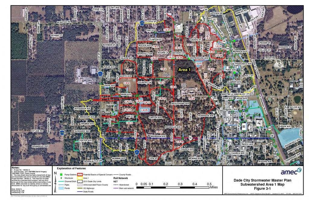
1 Page MAJOR DRAINAGE SYSTEMS The 1965 Master Plan Report for Storm Drainage Facilities ( 1965 Master Plan ) identified six primary subwatersheds within the Dade City study area. Each of these areas has its own drainage characteristics and potential problems, and for the most part each area is effectively isolated from the others due to local topographic conditions which are somewhat unique for Central Florida. Two of the subwatersheds, identified as Area V and Area VI, were excluded from consideration for potential stormwater improvements in the 1965 Master Plan, as at that time, very limited urban development was present in those areas. Most of Area V, located east of the CSX Transportation railroad right-of-way and roughly centered on River Road, to this date remains largely undeveloped, with significant portions of the subwatershed lying outside the limits of incorporated Dade City. With its location east of the CSX right-of-way, the primary causes of flooding concerns within this area are completely separate from those affecting the Dade City downtown area and locations adjacent to the downtown area. During development of the scope for this project, no drainage problem areas were identified by City staff in this area. For the reasons above, Area V is excluded from any study or consideration of future stormwater improvements in this report. Area VI as identified in the 1965 Master Plan encompasses an area south of the downtown area and roughly centered on the old Seaboard Air Line Railroad right-of-way that was converted to a multiple-use recreational trail in The northern part of this area has seen significant development in the years since the 1965 Master Plan was prepared including primarily single-family residential neighborhoods of medium and low densities. The City has not received any reports of significant flooding problems in this area. Because of this, portions of Area VI that lie within the incorporated city limits have been included in this report, but grouped with Area III and Area IV as identified in the 1965 Master Plan. Brief descriptions of the existing drainage systems in each of the four areas included for consideration in this report are summarized below. 3.1 Area 1 Subwatershed Please refer to Figure 3-1 below. Area 1 encompasses approximately 460 acres lying north and northwest of the Dade City downtown area. It is roughly bounded to the north by Lock Street (County Road 578), to the south by Meridian Avenue (State Road 52) and to the west by a sandy ridge located west of 21 st Street (State Road 52). North of Martin Luther King Jr. Avenue, the area is roughly bounded to the east by US Highway 301 (though some portion of the privately-owned Dade City Industrial Park is included). South of Martin Luther King Jr. Avenue, the eastern boundary of Area 1 is formed by the multi-use recreational trail occupying the old Seaboard Air Line railroad right-of-way.
2 Page 33
3 Page 34
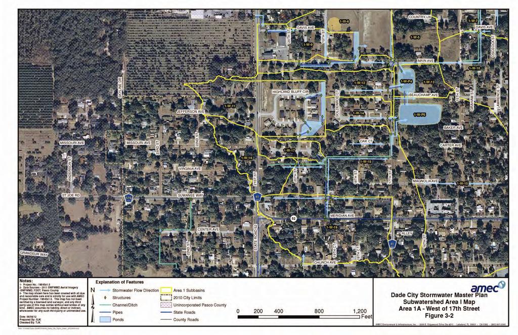
4 Page 35 The natural flow pattern of stormwater runoff through the area is roughly west to east, eventually outfalling to the Withlacoochee River floodplain. The presence of lower ridges and high spots within the subwatershed serve to divide the area into several smaller localized basins which are effectively closed under all except for the most extreme storm events. As development has proceeded over the years, the available surface area of sandy, well-drained soils throughout the subwatershed has significantly decreased, resulting in increased volumes of stormwater runoff accumulating and ponding in the low areas, causing street flooding and localized flooding of privately-owned parcels during larger rainfall events. The constructed storm water system within this subwatershed consists of several independent storm sewer and channel systems which serve the hydraulically isolated areas in the western part of the subwatershed, as well as a storm sewer system along US Highway 301 and the US Highway 301 Bypass (State Road 533) which is operated and maintained by the Florida Department of Transportation. These systems are briefly described below. Area 1AWest of 17 th Street Please refer to Figure 3-2 below. Stormwater runoff in this area flows east and north from the right-of-way of State Road 52 (Meridian Avenue) and County Road 41 (21 st Street) through a series of inlets and pipes designed to convey it in a controlled manner down the rather steep hills. South of Missouri Avenue, runoff enters a shallow concrete-lined channel which runs north from Meridian Avenue. From here the ditch becomes earthen and then turns easterly and runs adjacent to several properties located on Oak Court. The channel then turns to the north and abruptly terminates just south of the intersection of Oak Court and 17 th Street. The ditch has overflowed its banks several times as a result of high flows from intense rainfall events that have occurred in the 2012 rainy season. One property owner in the vicinity of Oak Court and 17 th Street has reported yard flooding and water damage to part of the home in the past and it is assumed that blockage in the ditch may have caused stormwater to overtop the ditch banks at that location. Stormwater runoff from the end of this ditch must run overland over Oak Court to drain to the Beauchamp pond drainage collection system. This isolated lack of drainage conveyance can create safety concerns and potentially could be part of the reason the residence was previously flooded. Between Missouri Avenue and Main Avenue, runoff flows easterly down gradient through a small subdivision (Highlands Bluff). This subdivision was constructed relatively recently, so it has several dry retention ponds which help to attenuate some of the runoff volume. Any runoff beyond the volume of this stormwater management system s capacity is discharged and continues to flow easterly toward 17 th Street.
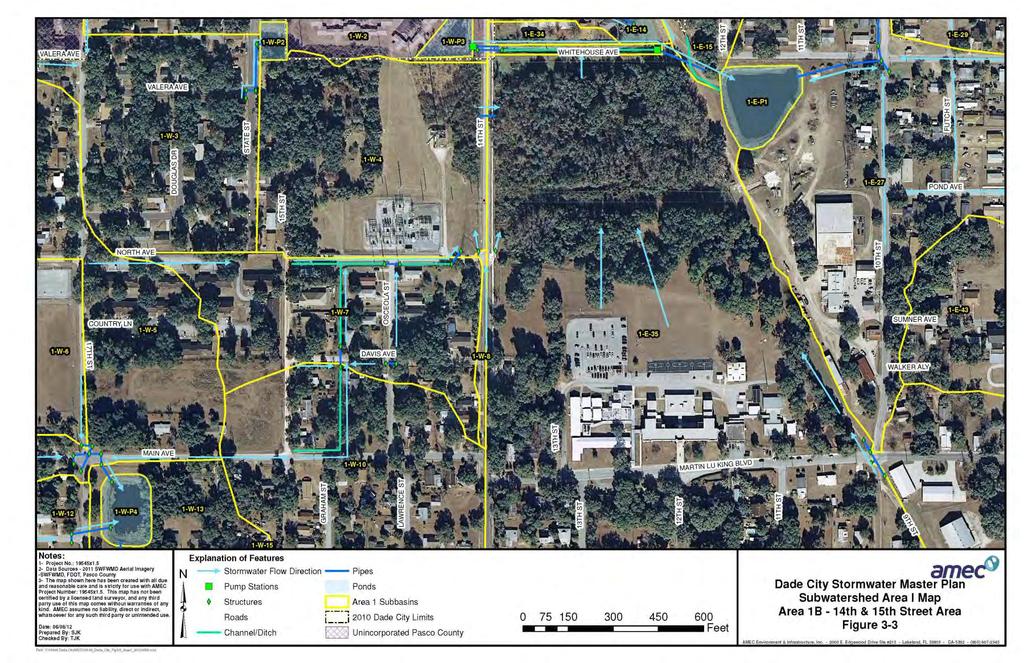
5 Page 36 Along Main Avenue, the City has recently constructed a storm sewer system which helps to convey water in a controlled manner down the hill toward 17 th Street. Some of this water is captured and diverted to a narrow dry retention pond located next to a City-owned recreational park at the northwest corner of the intersection of Main Avenue and 17 th Street. Excess runoff volume from this pond is discharged to the park by means of a concrete weir structure. Once stormwater runoff originating in the locations noted above reaches 17 th Street, it is conveyed by a series of pipe and inlet systems located at the major intersections to two ponds located on the northeast and southeast sides of the intersection of 17 th Street and Beauchamp Avenue. Stormwater runoff from areas located to the north of the ponds also flows into the ponds. These ponds are connected by a 24 equalizer pipe running under Beauchamp Avenue and form the lowest point of this portion of the subwatershed. The ponds are isolated from the rest of the subwatershed by a low ridge to the east, and no positive outfall from the pond system exists. The location of these ponds in relation to low lying areas that could receive overflow from these ponds makes construction of stormwater outfall very expensive. A conceptual CIP to enlarge the ponds, eliminate through-traffic and retain the existing utilities and pedestrian access only down Beauchamp Avenue between 15 th Street and 17 th Street is included in Chapter 10 (Alternatives Analysis) of this report. Additionally, a CIP to improve the existing ditch located behind Oak Court is also included in Chapter 10. Area 1B - 14 th Street to 15 th Street between Main Avenue and North Avenue Please refer to Figure 3-3 below. Stormwater runoff from this area, as well as from a somewhat higher region extending from Beauchamp Avenue south, is conveyed in a northward direction through a system of ditches and culverts to a 24 outfall pipe located near the intersection of North Avenue and 14 th Street. From this point, it is joined by runoff conveyed by two concrete flumes located on the east and west sides of 14 th Street to a wetland located north of the Tampa Electric Company (TECO) substation located in this area. Stormwater runoff entering this wetland is conveyed to the east by a 24 pipe running under 14 th Street, and discharges to a larger wetland on the east side of 14 th Street that is located on property owned by the Pasco County School Board. This wetland is bounded to the south by higher elevation portions of the school board property, to the north by a large drainage ditch and to the east by a berm which separates it from a pond located south of the intersection of Whitehouse Avenue and 12 th Street, on property owned by the City of Dade City. The berm is located along the old Seaboard Air Line Railroad right-ofway and was constructed as part of the grade for the railway. This pond will be discussed in greater detail later in this report and will be referred to as the Whitehouse Pond.
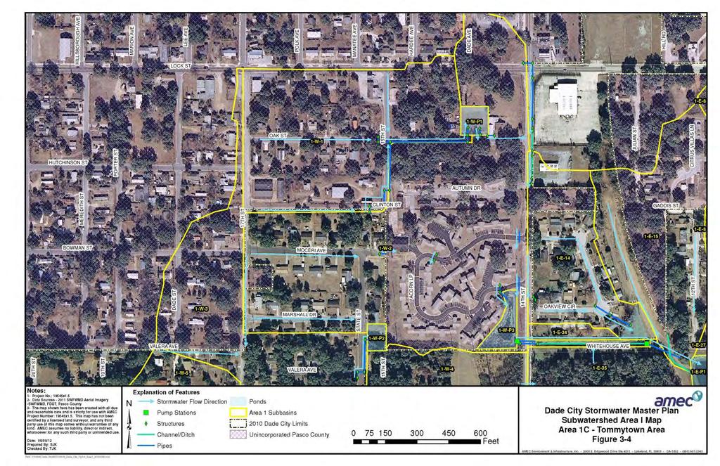
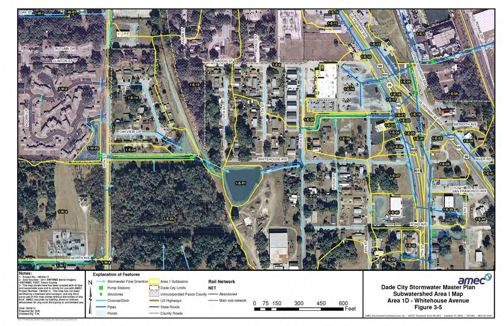
6 Page 37 Area 1C - Tommytown Area Please refer to Figure 3-4 below. The County recently constructed a stormwater management system along 15 th Street between Clinton Street and Oak Street. This system conveys runoff from Clinton Street, 15 th Street and Oak Street to a small retention pond located on the north side of Oak Street, approximately 200 feet west of 14 th Street. All areas served by this system lie at relatively high elevations. Runoff in excess of the design volume for the pond is discharged to a roadside ditch on the north side of Oak Street and flows easterly toward 14 th Street, where it is joined by runoff flowing through a pipe system from the north that captures stormwater runoff generated near the intersection of 14 th Street and Lock Street. Runoff continues to the south along 14 th Street, through a series of pipes and the roadside ditch that are in poor condition, until it reaches a large drainage ditch described below. The large drainage ditch is a shallow earthen ditch of a 15± feet bottom width and which runs from the east side of 14 th Street easterly to the west side of the Seaboard Air Line railroad right-of-way. All runoff in the ditch is discharged to the Whitehouse Pond by means of a Pasco County Housing Authority (PCHA) owned lift station via an 8 PVC stormwater force main. This lift station is located at the eastern end of the ditch. Additional stormwater runoff is discharged to the large ditch from the Dade Oaks Apartments housing complex located on Acorn Loop, owned by the PCHA. This development lies at a considerably lower elevation than the developments along Clinton Street and State Street, located to the north and west, respectfully. A small pipe and inlet system conveys runoff to a retention pond located at the southeast corner of the PCHA property, and water from this pond is discharged to the large drainage ditch to the east via a stormwater lift station operated by the PCHA. Both lift stations are manually operated, and no operating data was made available by the PCHA for this report. Additional runoff contributions to large drainage ditch come from the neighborhood located to the north on Oakview Circle. Area 1D - Whitehouse Avenue Please refer to Figure 3-5 below. The portion of Whitehouse Avenue between 10 th Street and 12 th Street includes the topographic low point for the entire subwatershed and has been subject to flooding problems for years. This area receives runoff not only from the Whitehouse Pond discharges but also from the storm sewer system for US Highway 301 (7 th Street) between Pond Avenue and the Dade Village Shopping Center. As designed, runoff from 7 th Street enters a shallow ditch running along the south side of the shopping center property and is then conveyed westerly and then southerly to the Whitehouse Pond by means of a small storm sewer system.
7 Page 38 The low area noted above is connected to the outlet for the entire subwatershed by means of other portions of the US Highway 301 storm sewer system between Lock Street and the merge of the US Highway 301 Bypass and 7 th Street. Stormwater modeling revealed a hydraulic high point that exists along the US Highway 301 right-of-way during significant storm events. This, along with the small size of the Whitehouse Pond and the relatively high amount of directly connected impervious area present in this portion of the watershed causes water to pond in the ditch and 10 th Street area for long periods of time after storm events. This results in street and yard flooding and infrequent flooding of homes in the area.
8 Page 39
9 Page 40
10 Page 41
11 Page 42
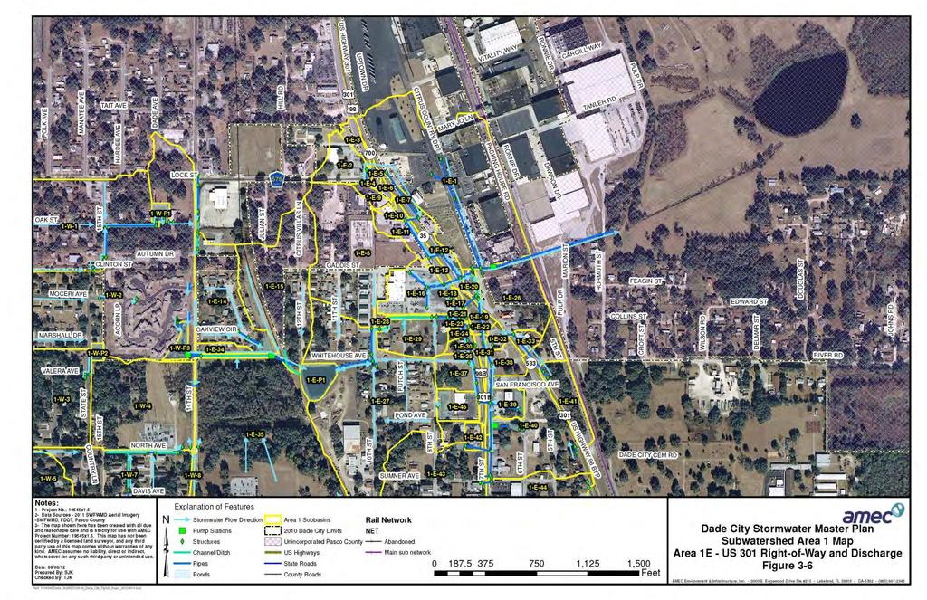
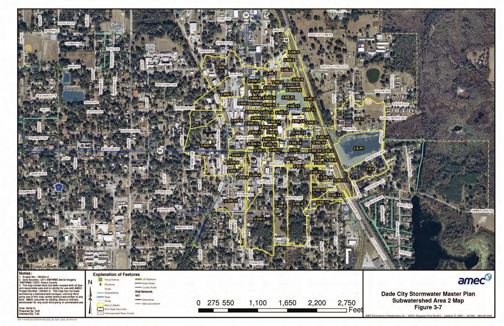
12 Page 43 Area 1E - US Highway 301/US Highway 301 Bypass Right-of-Way and Discharge Point Please refer to Figure 3-6. The storm sewer system for US Highway 301 within the subwatershed connects the right-of-way for US Highway 301 and the US Highway 301 Bypass between Lock Street to the north and Martin Luther King Jr. Blvd. to the south with the discharge point for the entire subwatershed. Runoff from the north is conveyed through a series of pipes starting at the intersection with Lock Street that terminates at a 36 RCP discharging to a short roadside ditch on the west side of Citrus Country Drive (Old State Road 23). Runoff from the south enters this ditch by means of a 36 pipe and a 42 pipe which convey runoff from the right-of-way for 7 th Street, as well as commercial properties adjacent to the right-of-way. An additional contribution is made from the US Highway 301 Bypass right-ofway to south of River Road. The discharge point for subwatershed Area I is a stormwater lift station owned and operated by the Pasco Cogeneration Plant, at the south side of the Dade City Business Center. The lift station capacity is 11,000 gallons per minute (24.6 cubic feet per second) for the two existing pumps pumping at design head, and discharge to the Withlacoochee River floodplain system is to the east by means of a 30 pipe which runs under the CSX Transportation railroad right-of-way. This is the only current conveyance located under the railroad right-of-way in this area. Besides the contributions to runoff volume from the subwatershed, the lift station also receives runoff from the Business Center and Pasco Cogen Plant properties. Given the size of the overall contributing portions of the subwatershed, as well as the amount of impervious surface present, this outfall is significantly undersized. During the majority of the modeled storm events, it is clearly evident that the lift station requires time to lower the flood water elevation to a level where positive discharge can occur from the 10 th Street and Whitehouse Avenue area and relieve the flooding in that area. 3.2 Area 2 Subwatershed- Downtown Drainage Basin Please refer to Figure 3-7 below. Area 2 is approximately 199 acres in size, of which the majority includes the downtown area of Dade City. This subwatershed is roughly bounded by Martin Luther King Jr. Drive to the north, Howard Avenue to the south, and 11th Street to the west.. While the primary drainage divide for the subwatershed on the east is the CSX Transportation railroad right-of-way, the old wastewater treatment polishing pond located near the City-owned Irvin Park and the adjoining neighborhoods to the north and south are also included in this drainage basin. Virtually all stormwater runoff from the downtown area is routed to the pond Irvin pond before ultimately discharging to the Withlacoochee River floodplain to the east.
13 Page 44 Because this subwatershed encompasses downtown Dade City, it has the most extensively developed stormwater infrastructure in the entire study area. Unfortunately, the system is undersized for the current level of development in the downtown area, and frequent flooding of streets and parking areas is experienced by downtown businesses and their customers even during routine rainfall events. During these storms, a significant amount of stormwater runoff flows overland in a generally northward and eastward direction toward the US Highway 301 Bypass, reaching depths and velocities of safety concern to pedestrians and motor vehicles as it flows down the City streets. The downtown area lies at the foot of topographic ridges located to the south and west. Because of the significant topographic relief in the area, stormwater runoff flows can achieve high velocities as it makes its way downhill. Over the years, the downtown area has been almost completely covered with impervious surfaces from commercial and roadway development. This has significantly reduced any opportunity for stormwater runoff to infiltrate into the soil. Most of this development predates environmental resource permitting requirements adopted by SWFWMD in the 1980s, and as a result it lacks retention ponds or other measures which would serve to attenuate the increased volume and rate of stormwater runoff from the development process. Please refer to Figure 3-8 below. The main trunk for the downtown storm sewer system originates with several inlets connected by 15-inch pipes located at the intersection of Meridian Avenue and 7 th Street. Parking lot drainage from businesses located west of this intersection is conveyed to the main system via overload flow along the roadway curb lines. The main storm sewer trunk continues eastward along Meridian Avenue to the intersection of 6 th Street, where it turns to the north and continues northward until it reaches the intersection of 6 th Street and Madill Avenue, increasing in size to 30 inches. Laterals join the main trunk at the following intersections, listed in order from south to north. Live Oak Avenue; one inlet connected by a 12-inch pipe. Pineapple Avenue; one 24 lateral conveying runoff eastward from the vicinity of Pineapple Avenue and 8 th Street. One inlet connected by a 12 x 18 pipe that drains an empty lot at the intersection. Robinson Avenue; one parking lot drain inlet connected by a 15-inch pipe. Madill Avenue; one 30-inch lateral conveying runoff eastward from a series of inlets at the intersection of Madill Avenue and 7 th Street. Two 14 x 23 pipes and one 15-inch pipe receiving runoff from small localized areas adjacent to 6 th Street. From the 6 th Street Madill Avenue intersection, the main trunk increases to 36 inches in size and turns eastward until it reaches 5 th Street, crossing the East Pasco Government Center complex. This complex was constructed in the late 1990s time period and has a separate stormwater management system that ultimately discharges to the same receiving system as the downtown stormwater trunk line. This system is described in more detail below.
14 Page 45 Once the main storm sewer trunk reaches the east side of 5 th Street, it joins a 48 pipe which runs northward to a shallow ditch. This ditch conveys stormwater easterly toward the US Highway 301 Bypass right-of-way adjacent to a large low flood prone area located on the north side of the Pasco County Courthouse facility. This low area serves as a surge pond for large storm events. Stormwater runoff from the main storm sewer trunk is joined by additional runoff from areas along 8 th, 7 th, 6 th and 5 th Streets north of Madill Avenue, which is conveyed through a series of manholes, inlets and pipes to the ditch. Other inlets and pipes convey runoff from 6 th Street between Pineapple Avenue and Robinson Avenue, and 5 th Street south of Live Oak Avenue, to the drainage ditch as well. Once the drainage ditch connects to the US Highway 301 Bypass roadside ditch, it joins stormwater runoff from the highway and flows southward to a 48 concrete culvert that runs under the highway. This cross drain also receives runoff from the south, through the roadside ditch from the following locations. FDOT storm sewer system; the portion of the US Highway 301 Bypass right-of-way contributing runoff to this cross drain includes the area between Church Avenue and Meridian Avenue. The storm sewer terminates with a 36 pipe discharging to the roadside ditch just north of Meridian Avenue. Pasco County Courthouse; one 18-inch outfall and one 24-inch outfall convey parking and roadway runoff from the courthouse complex to the US Highway 301 Bypass roadside ditch. Intersection of Live Oak Avenue and 3 rd Street; a small storm sewer system is connected by a 24 pipe discharging to a shallow ditch which runs easterly to the highway ditch.
15 Page 46
16 Page 47
17 Page 48
18 Page 49 Please refer to Figure 3-9 below. The East Pasco Government Center was subject to SWFWMD environmental resource permitting rules and was required to construct a stormwater management system. Stormwater runoff from the site is collected in a series of pipes and inlets, and is conveyed to a retention pond located on the east side of 5 th Street, immediately north of the main drainage ditch for the downtown area. From this retention pond, water is discharged through a concrete control structure to a separate holding cell to the east of the pond, and then to the drainage ditch by means of an earthen weir structure. Stormwater flowing through the 48 cross drain under the US Highway 301 Bypass is conveyed through a short channel to another 48 cross drain under the CSX Transportation railroad embankment. Stormwater runoff is then conveyed toward the south through an open channel until it outfalls into Irvin pond. This pond was originally constructed to impound and polish treated effluent from the City s wastewater treatment plant, but the plant no longer discharges to it. The pond is approximately 7 acres in size at the berm and has a bottom elevation of approximately 64 ft. NAVD. The seasonal high water table elevation for the pond has been estimated at 68.3 ft. NAVD. Stormwater is discharged from the pond via a variable sized culvert under Canal Street where it flows easterly to a wetland system connected to the Withlacoochee River floodplain. The cross drain is in very poor condition. 3.3 Area 3 Subwatershed Please refer to Figure 3-10, Figure 3-11, Figure 3-12, Figure 3-13, and Figure 3-14 below. The Area 3 subwatershed identified in the 1965 Master Plan was not bounded to the south and east, so for this update a defined boundary was created by means of topographical analysis and review of the current incorporated limits of Dade City. The area considered for this study is approximately 1,540 acres in size, and is located southwest of the downtown area, roughly centered on State Road 52 south of Meridian Avenue. Much of the area remains undeveloped, though numerous permit applications have been filed with SWFWMD to authorize construction of new subdivisions. The majority of growth in the Dade City area is occurring within this subwatershed. The area consists of high ridges and plateaus on sandy, well drained soils, and the City has experienced flooding problems in the vicinity of Howard Avenue near the crossing for the multipurpose recreational trail. Frequent street flooding to the extent that road closure is necessary is experienced in this portion of the subwatershed. This portion of the subwatershed is discussed in greater detail below, as alternatives to address this flooding are a priority to the City. The City has not received flooding complaints for the remainder of this subwatershed. Much of the current development is new, and was therefore required to include stormwater management systems when applying for construction permits. Future projects will also require the incorporation of stormwater management systems that meet
19 Page 50 the City s more stringent Drainage Basin of Special Concern (DBSC) criteria. The majority of the Area 3 subwatershed is part of the Tank Lake DBSC, which is designated a closed basin and an area of special criteria and is discussed later in this report. The general surface water runoff pattern through this area is from north to south, as runoff flows down the hills and is conveyed under the right-of-way for State Road 52, Old San Ann Road and Fort King Road (County Road 41) by means of box culvert structures. These culverts allow stormwater to enter wetlands and other low-lying areas, which convey it in a generally east-to-southeastward direction toward the Withlacoochee River floodplain system. Much of the area located west and north of State Road 52 and south of St. Joe Road (County Road 578) is located in a hydrologically closed basin draining to a large pond and low-lying area located northeast of the Abbey Glen subdivision. The most significant City maintained feature in this area is a stormwater lift station located at the Florida Avenue crossing of the multi-purpose recreational trail. Runoff from this portion of the subwatershed is collected in a storm sewer trunk line that originates at Pasco Avenue and runs southward along the right-of-way for the multipurpose trail. This trunk line is connected to another trunk line that travels north from Pasco Avenue, crosses Meridian Avenue (State Road 52) at 8 th Street, and continues northward to Pineapple Avenue, where it is routed to the storm sewer system along 6 th Street in the downtown area (Area 2). There are two curb inlets located near the intersection of Pasco Avenue and 8 th Street: the inlet on the south side of Pasco Avenue contains the high points of the storm sewers running northward to Area 2 and southward to Area 3, and serves as the break between the two subwatersheds in this area. The storm sewer within Area 3 is an 18 clay pipe at Pasco Avenue and traverses south, joining drainage laterals from Howard Avenue and Hendley Avenue, as well as inlets that connect at McMinn Avenue. The system terminates at the lift station on Florida Avenue as a 30 RCP. Please refer to Figure 3-15 below for additional detail of the system. Several years ago the City constructed improvements for the Howard Avenue system in an attempt to address the previously noted street flooding within a vertical low point along the Howard Avenue alignment, located feet west of the trail crossing. These improvements included replacing and upsizing piping and inlets on Howard Avenue, and the construction of a small surge pond at the southwest corner of the trail crossing at Howard Avenue. These improvements saw only limited success. Stormwater runoff entering the wet well at the Florida Avenue lift station is pumped southward under Florida Avenue through a rectangular culvert, and discharges to a drainage ditch running along the east side of the multi-purpose trail. From this ditch, water continues to flow southward into a series of wetlands and low-lying areas, before turning eastward and ultimately discharging to the Withlacoochee River floodplain.
20 Page 51 Other significant drainage structures in this area include a series of roadside ditches and culverts located on the east side of the State Road 52 right-of-way that extend from Church Avenue southward to a point approximately 450 feet south of Coleman Avenue. Stormwater runoff is conveyed and discharged into the wetland system that flows under Old San Ann Road. Another system of pipes, inlets and roadside ditches conveys stormwater southward along 17 th Street from Colman Avenue to the wetland system near Dixie Avenue. It is noted that discharge from the stormwater lift station located at the Florida Avenue crossing of the multi-purpose recreational trail is conveyed through Area 3 via the ditch that runs along the east side of the trail. The discharge is within the Tank Basin DBSC and is therefore subject to the DBSC criteria. Any drainage improvements that increase the capacity of the lift station and/or its immediate downstream conveyance have the potential to create localized flooding problems for property owners and residents near the trail. 3.4 Area 4 Subwatershed Please refer to Figure 3-16, Figure 3-17 and Figure 3-18 below. The final subwatershed evaluated for this study, Area 4 is approximately 230 acres in size and lies east of Area 3 and south of Area 2, centered roughly on the split of 7 th Street and the US Highway 301 Bypass. The area to the northwest of the Bypass consists primarily of medium density residential neighborhoods constructed on relatively high ground, while the area southeast of the Bypass is more sparsely developed, situated on low-lying ground that slopes down toward the east. The most significant drainage structures in this area are the pipes and inlets that make up the storm sewer system for US Highway 301 and the US Highway 301 Bypass. The storm sewer system begins at the intersection of US Highway 301 and Lake Drive, and several commercial developments adjacent to the right-of-way have outfalls into the system. Stormwater runoff is conveyed northward to a 42 pipe that discharges eastward to a large ditch hardened with concrete, which then conveys runoff eastward toward the Withlacoochee River floodplain. Additional runoff from 7 th Street north of the split, and 5 th Street at Hibiscus Park, is also routed to this 42 outfall by a series of pipes and inlets. Additionally, this outfall receives discharge from a City-owned pond located directly west of the US Highway 301 Bypass/7 th Street split. The control structure for this pond is in poor condition. A smaller storm sewer system originating at the intersection of the US Highway 301 Bypass and Buford Avenue conveys runoff to a small borrow pit lying directly west of the Bypass approximately 200 feet south of the intersection with Howard Avenue. Some runoff is discharged under the Bypass roadway by means of a 36 cross drain, while other runoff continues south within the Bypass right-of-way through roadside ditches and driveway culverts until it reaches a 42 cross drain located approximately 530 feet south of the Coleman Avenue intersection.
21 Page 52 Once stormwater runoff leaves the US Highway 301 Bypass right-of-way, it continues to flow eastward through a series of small sloughs and channels until it reaches the right-ofway of Old Lakeland Highway (County Road 35A), where it discharges to the adjacent CSX Transportation railroad right-of-way via a 48 pipe. En route to this outfall point, runoff is bypassed around a cattle ranch (Sid Larkin Property) by means of a high berm which isolates the wetlands on the Larkin property from the main stormwater conveyance system. The wetlands on the Larkin property were designated by SWFWMD under an environmental resource permit. Pasco County is currently proposing a project with the placement additional pipes under the CR 35A roadway. After flowing under the CSX railroad right-of-way, stormwater runoff is conveyed under Wilson Street by a metal pipe that is in exceptionally poor condition (this connection is proposed for upgrade as well) and discharges to the Boiler Lake system, which is part of the Withlacoochee River floodplain. At the north end of Wilson Street there is a small neighborhood that is built around a series of shallow canals. These canals are connected to the Boiler Lake System by means of culvert crossings under Wilson Street. However, the inverts for the culverts are placed approximately 2 3 feet above the canal bottoms, and as a result the canals are filled with stagnant water almost year-round. These canals do not appear to serve any sort of drainage function, and were likely dug out for fill material to build the adjacent area up for development. The only other drainage structures of note are a series of small pipes, inlets and channels located at the east ends of Dixie Avenue and Sunset Avenue, which serve to convey street runoff from these roads to the receiving system to the east. The City has received no flooding complaints from residents or businesses in this subwatershed. However, during a field visit by AMEC staff, a City Public Works employee noted that during rainfall events, significant sheet flow coming down 5 th Street adjacent to Hibiscus Park causes scour at th Street. A possible cause of this scour is surface overflows from swales and inlets lying within the FDOT right-of-way that are in need of maintenance.
22 Page 53
23 Page 54
24 Page 55
25 Page 56
26 Page 57
27 Page 58
28 Page 59

29 Page 60
30 Page 61
31 Page 62
continues in the watershed, additional flood control and water quality / natural system improvements may be required in the future.
 The Duck Pond Watershed is located in northern Hillsborough County in an area in which a number of land and water management issues are currently being addressed by citizen's action groups and state, regional
South Bismarck Watershed Model Update and Stormwater Improvement Project
 Preliminary Engineering Report Bismarck Tribune South Bismarck Watershed Model Update and Stormwater Improvement Project City of Bismarck, ND January 2017 14.105.0046 1.0 Executive Summary The focus of
POLE BRIDGE ROAD NEAR FIVE LOT FARM
 Drainage Improvements Village of Avon Pole Bridge Road near Five Lot Farm December 2014 POLE BRIDGE ROAD NEAR FIVE LOT FARM Pole Bridge Road is the eastern border of the Village south of NYS route 5 &
PRELIMINARY DRAINAGE REPORT LATHAM 200 MMSCFD GAS PROCESSING PLANT
 PRELIMINARY DRAINAGE REPORT LATHAM 200 MMSCFD GAS PROCESSING PLANT LOTS B, RECORDED EXEMPTION 1211-2-1, RECX13-0096 LOCATED IN THE NORTH 1/2 OF SECTION 2, TOWNSHIP 3 NORTH, RANGE 66 WEST, 6 TH PRINCIPAL
MASTER DEVELOPMENT DRAINAGE PLAN FOR MONUMENT HEIGHTS
 MASTER DEVELOPMENT DRAINAGE PLAN FOR MONUMENT HEIGHTS DRAINAGE REPORT STATEMENT ENGINEER'S STATEMENT: The attached drainage plan and report were prepared under my direction and supervision and are correct
PHASE III DRAINAGE REPORT
 PHASE III DRAINAGE REPORT FOR Eastlake Assisted Living & Memory Care April 20, 2016 June 3, 2016 August 5, 2016 Prepared for: 3301 E 120 th Ave, LLC. 8200 E. Maplewood Ave., Suite 150 Greenwood Village
Leduc Industrial Outline Plan SE W4
 Leduc Industrial Outline Plan SE 1-50-25-W4 Within the North Leduc Industrial ASP Prepared for: Leduc Energy Park Ltd. Prepared by: Stantec Consulting Ltd. File No. 1161 104655 V5 Table of Contents 1.0
Village of New Maryland. Storm Water Management Master Plan
 Village of New Maryland Storm Water Management Master Plan Village of New Maryland Storm Water Management Master Plan Fredericton Office 80 Bishop Drive Fredericton NB E3C 1B2 Canada Telephone: +1 506
When planning stormwater management facilities, the following principles shall be applied where possible.
 2.0 Principles When planning stormwater management facilities, the following principles shall be applied where possible. 2.0.1 Drainage is a regional phenomenon that does not respect the boundaries between
City of Waco Stormwater Management Regulations
 1.0 Applicability: City of Waco Stormwater Management Regulations These regulations apply to all development within the limits of the City of Waco as well as to any subdivisions within the extra territorial
C. WATER. 1. Surface Water Runoff. See Section C.3, Flood Hazard/Mudflow Hazard, page Ground Water
 C. WATER 1. Surface Water Runoff See Section C.3, Flood Hazard/Mudflow Hazard, page 67. 2. Ground Water Determined not significant by the October 1984 and January 1999 Initial Studies conducted by the
Project Descriptions for FY 15
 Department of Transportation and Stormwater Services Stormwater Engineering and Design Division Project Descriptions for FY 15 43 rd Street Outfall PH II Pond Regional Drainage Improvement Flooding Relief
C ity of Grande Prairie Development Services Department
 C ity of Grande Prairie Development Services Department FAIRWAY DEVELOPMENT OUTLINE PLAN OP 08 09 Approved April 6, 2009 Prepared by: Focus Corporation Table of Contents 1.0. Introduction 2 3 1.1. Plan
Pond Siting Report Update
 Pond Siting Report Update Prepared for: Florida Department of Transportation District 5 CR 46A Realignment from SR 46 to North of Arundel Way Lake County, Florida FPID No. 238275-8-32-02 October 2013 (Draft
Table of Contents G.1.a Water Resources - Surface Water - Drainage
 Table of Contents G.1.a Water Resources - Surface Water - Drainage 1. INTRODUCTION... 1335 2. ENVIRONMENTAL SETTING... 1335 a. Regional Hydrology... 1335 b. Local Hydrology... 1337 c. On-site Hydrology...
LOUISIANA STATE UNIVERSITY COMPREHENSIVE & STRATEGIC CAMPUS MASTER PLAN. APPENDIX G - Stormwater Study Findings & Stormwater Solutions
 LOUISIANA STATE UNIVERSITY COMPREHENSIVE & STRATEGIC CAMPUS MASTER PLAN APPENDIX G - Stormwater Study Findings & Stormwater Solutions LSU: MP Narrative July 2017 3.5 Open Space Existing Conditions The
5. LOW IMPACT DEVELOPMENT DESIGN STANDARDS
 5. LOW IMPACT DEVELOPMENT DESIGN STANDARDS Low Impact Development (LID) requires a shift in stormwater management away from conveying runoff to a small number of downstream points through hydraulically
STAFFORD TRACT NORTH OF US90A 1.0 INTRODUCTION 1.1 OBJECTIVE
 1.0 INTRODUCTION 1.1 OBJECTIVE This report, prepared for submittal to TxDOT, analyzes existing and proposed detention facilities draining into the TxDOT US90A storm sewer system. The results of the detailed
Figure 1 Cypress Street Study Area Location Map
 July 20, 2016 TO: FROM: Jim Massarelli Director of Engineering Jeff Julkowski, PE Michael Burke, PE SUBJECT: Cypress Street Study Area Stormwater Analysis (CBBEL Project No. 16-0058) At the request of
City of Grande Prairie Development Services Department KENNEDY DEVELOPMENTS LTD. OUTLINE PLAN OP-09-01
 City of Grande Prairie Development Services Department KENNEDY DEVELOPMENTS LTD. OUTLINE PLAN OP-09-01 July 27, 2009 TABLE OF CONTENTS 1.0 Introduction... 1 1.1 Plan Area Location & Context... 1 1.2 Ownership
Project Narrative For Fruita RV Resort Conditional Use Permit
 Project Narrative For Fruita RV Resort Conditional Use Permit Date: November 18, 2016 Prepared by: Robert W. Jones, II, P.E. Vortex Engineering & Architecture, Inc. 2394 Patterson Rd., Ste. 201 Grand Junction,
STORMWATER REPORT FOR WALMART SUPERCENTER STORE # SIOUX FALLS, LINCOLN COUNTY, SOUTH DAKOTA BFA PROJECT NO
 STORMWATER REPORT FOR WALMART SUPERCENTER STORE # 2443-00 SIOUX FALLS, LINCOLN COUNTY, SOUTH DAKOTA BFA PROJECT NO. 3286 March 1, 2012 I hereby certify that this engineering document was prepared by me
Stormwater Retrofitting: The Art of Opportunity. Presented by the Center for Watershed Protection
 Stormwater Retrofitting: The Art of Opportunity Presented by the Center for Watershed Protection What Are Stormwater Retrofits? Retrofits are stormwater management measures inserted in an urban or ultra-urban
CHECKLIST FOR PHASE II DRAINAGE REPORT
 I. COVER SHEET CHECKLIST FOR PHASE II DRAINAGE REPORT A. Name of Project B. Address C. Owner D. Developer E. Engineer F. Submittal date and revision dates as applicable II. GENERAL LOCATION AND DESCRIPTION
OP Council Resolution June 16, Planning and Development Services
 OP-08-01 Council Resolution June 16, 2008 Planning and Development Services Kingsgate Landing Outline Plan Table of Contents 1.0 Introduction 1 1.1 Purpose of Plan 1 1.2 Plan Area Location 1 1.3 Ownership
Drexel, Barrell & Co.
 Drexel, Barrell & Co. June 18, 2018 Engineers/Surveyors Boulder Colorado Springs Greeley 3 South 7 th Street Colorado Springs, Colorado 80905-1501 719 260-0887 719 260-8352 Fax El Paso County Planning
Appendix K. Stormwater Management Plan
 Regional Municipality of Halton - Steeles Avenue (Regional Road 8) Class EA - Industrial Drive to Regional Road 25/Martin Street Appendix K Stormwater Management Plan PR226401.001 Rev. 2 PR.DOT, 00/01
City of Elmhurst. City of Elmhurst. Storm Sewer System Workshop November 22, 2010
 City of Elmhurst City of Elmhurst Storm Sewer System Workshop November 22, 2010 1 City of Elmhurst Watershed divide (green dashed line) through Elmhurst Area east of divide drains to Addison Creek Area
Appendix A Basin Inventory Summary
 Appendix A Basin Inventory Summary Surface Water Management Element A-1 BASIN INVENTORY SUMMARY Pinellas County is divided into 52 individual watersheds. The following Basin Inventory Summary includes
October 7, City of Thornton 9500 Civic Center Drive Thornton, CO (303) RE: Maverik Thornton, CO - Drainage Report
 RE: Maverik Thornton, CO - Drainage Report") October 7, 2016 City of Thornton 9500 Civic Center Drive Thornton, CO 80229 (303) 538-7295 RE: Maverik Thornton, CO - Drainage Report As per your request, we are submitting to you the drainage report and
October 7, 2016 City of Thornton 9500 Civic Center Drive Thornton, CO 80229 (303) 538-7295 RE: Maverik Thornton, CO - Drainage Report As per your request, we are submitting to you the drainage report and
APPENDIX B. Hydrologic and Hydraulic Analysis
 APPENDIX B Hydrologic and Hydraulic Analysis HYDROLOGIC AND HYDRAULIC ANALYSIS PETERSBURG ROAD IMPROVEMENTS DOT&PF Project No. 67879 Prepared for: State of Alaska Department of Transportation and Public
S o u t h C e n t r a l O u t l i n e P l a n. Leduc Business Park. North Leduc Industrial Area Structure Plan C it y of Led u c.
 Leduc Business Park North Leduc Industrial Area Structure Plan C it y of Led u c Prepared for Farm Air Properties Inc. January, 2007 Table of Contents Page Number 1.0 Purpose of Plan and Definition of
MANUAL OF DESIGN, INSTALLATION, AND MAINTENANCE REQUIREMENTS FOR STORMWATER MANAGEMENT PLANS
 MANUAL OF DESIGN, INSTALLATION, AND MAINTENANCE REQUIREMENTS FOR STORMWATER MANAGEMENT PLANS May 2007 SECTION 1 Responsibility of Applicant TABLE OF CONTENTS A. Stormwater Management Plan Required Information
BRISBANE BAYLANDS INFRASTRUCTURE PLAN FEBRUARY 2011 APPENDIX O DRAFT
 BRISBANE BAYLANDS INFRASTRUCTURE PLAN FEBRUARY 2011 APPENDIX O DRAFT PRELIMINARY STORM DRAIN CALCULATIONS ASSOCIATED WITH BRISBANE BAYLANDS REDEVELOPMENT BRISBANE, CALIFORNIA Prepared by BKF Engineers
Level 1 Downstream Analysis
 Level 1 Downstream Analysis Newcastle Way Apartments Newcastle, Washington King County April 14, 2014 Revised July 10, 2014 Prepared by: Dean A. Furr, P.E. Reviewed by: Donald Scarberry, P.E. Coffman Engineering,
City of Elmhurst. Comprehensive Flood Plan. City of Elmhurst. City Council Meeting September 15, 2014
 City of Elmhurst City of Elmhurst Comprehensive Flood Plan City Council Meeting September 15, 2014 City of Elmhurst Presentation Overview Study Background Study Methodology Analysis of Three Additional
Chapter 3 MAJOR CONVEYANCE SYSTEMS
 Chapter 3 MAJOR CONVEYANCE SYSTEMS 3.1 Introduction This chapter contains a general description of the major conveyance systems in the LSC watershed. The existing conditions system performance and potential
Mitchell Ranch South MPUD Application for Master Planned Unit Development Approval Project Narrative. Introduction
 Mitchell Ranch South MPUD Application for Master Planned Unit Development Approval Project Narrative Introduction Mitchell Ranch South is a proposed single family (detached) residential development on
City of Grande Prairie Development Services Department
 City of Grande Prairie Development Services Department ROYAL OAKS NORTH OUTLINE PLAN OP-07-03 NW 35-71-6 W6M May 7, 2007 Royal Oaks North Outline Plan TABLE OF CONTENTS 1.0 INTRODUCTION........ 3 1.1 Purpose
Moon Brook FRP BMP Summary Sheet. Ownership of Land where BMP is Located
 Outlet Retrofit Hitzel Terrace The town owned parcel along Hitzel Terrace is a natural wetland area which currently provides some level of stormwater detention and peak-flow attenuation. The proposed project
Pollutant Removal Benefits
 Bioswales Bioswales Similar to biocells, but have a slight, but positive grade toward an outlet Designed to convey the WQv event at very low velocities Promote filtration through native vegetation, infiltration
FLOOD ISSUE 62 INTRODUCTION
 V I S I O N 2 0 3 0 Southwest Missouri is known for its extreme range in weather that can cause flash flooding in a moment s notice. This flooding can unfortunately lead to extreme damage and serious injury,
PROJECT SCOPE OF WORK CITY OF TOWN AND COUNTRY STORMWATER PROGRAM
 PROJECT SCOPE OF WORK CITY OF TOWN AND COUNTRY STORMWATER PROGRAM Project ID Number: 25-5 Problem: Stormwater collected from the neighborhood upstream is released at 9 Muirfield Lane and flows west toward
Erosion & Sediment Control Plan Application Form & Checklist
 Erosion & Sediment Control Plan Application Form & Checklist GENERAL INFORMATION Application Date: Project Address: Tax Map / Parcel Number(s): PROPERTY OWNER / DEVELOPER Firm Name: Contact Person: Title:
Huntington Stormwater Utility
 Huntington Stormwater Utility Stormwater Management & Sediment and Erosion Control Requirements for Construction Sites Authorized by Huntington City Code Articles: 971, 970, 930, 935, 955, Revised April
USF System Campus Master Plan Updates Goals, Objectives and Policies
 2015-2025 USF System Campus Master Plan Updates Goals, Objectives and Policies Tampa Goals, Objectives, and Policies Table of Contents Executive Summary 2015 2025 USF Campus Master Plan Update Introduction
HEALTH SCIENCES BUILDING REDEVELOPMENT PROJECT
 INTRODUCTION In recent years, the University of Cincinnati (University) has demonstrated a commitment to identifying and implementing sustainable goals and objectives throughout University s Uptown Campuses.
Draft Rhode Island Stormwater Design and Installation Standards Manual
 Draft Rhode Island Stormwater Design and Installation Standards Manual Summary The May 2009 Public Review Draft version of the RI Stormwater Design and Installation Standards Manual consists of approximately
4.6. Low Impact and Retentive Grading
 4.6. Low Impact and Retentive Grading Low Impact Grading techniques focus on utilizing existing topography during Site layout to minimize cost. Proposing structures, roads, and other impervious surfaces
NAPA COUNTY PUBLIC WORKS Standards & Specifications
 Roadway Design & Construction Manual (Table of Contents) 1. Chapter 1: General Provisions 1.1 Short Title 1.2 Jurisdiction 1.3 Purpose and Effect 1.4 Enactment Authority 1.5 Amendment and Revisions 1.6
Village of Forest Park. July 27, Sewer Separation Evaluation
 Village of Forest Park July 27, 2015 Sewer Separation Evaluation Presentation Overview Study Background Historic Nature of Forest Park Drainage Scale of Flooding Problem Forest Park Sewer System Background
Drexel, Barrell & Co.
 Drexel, Barrell & Co. December 21, 2018 Engineers/Surveyors Boulder Colorado Springs Greeley 3 South 7 th Street Colorado Springs, Colorado 80905-1501 719 260-0887 719 260-8352 Fax El Paso County Planning
APPENDIX C: STORMWATER CONTROL PLAN
 APPENDIX C: STORMWATER CONTROL PLAN STORM WATER MANAGEMENT PLAN FOR PLEASANT HILL, CALIFORNIA Prepared for Compliance with the Clean Water Program (C.3) and the San Francisco Bay Regional Water Quality
13. PRELIMINARY PLAT NO MILLS FARM - Vicinity of the southeast corner of 159 th Street and Quivira Road
 13. corner of 159 th Street and Quivira Road 1. APPLICANT: HNTB Corporation is the applicant for this request. 2. REQUESTED ACTION: The applicant is requesting approval of a preliminary plat for a 383-lot
CRYSTAL LAKE FLOODING STUDY
 Project #08223 CRYSTAL LAKE FLOODING STUDY PREPARED FOR: City of Crystal Lake 100 W. Municipal Complex Crystal Lake, Illinois 60039-0597 REVISED MARCH 19, 2009 26575 W. COMMERCE DRIVE, SUITE 601, VOLO,
WQ-23 MOUNTAINOUS AND STEEP SLOPE SITES
 Greenville County Technical Specification for: WQ-23 MOUNTAINOUS AND STEEP SLOPE SITES 1.0 Mountainous and Steep Slope Sites 1.1 Description The geographic locations of portions of Greenville County are
Chapter 4 - Preparation of Stormwater Site Plans
 Chapter 4 - Preparation of Stormwater Site Plans The Stormwater Site Plan is the comprehensive report containing all of the technical information and analysis necessary for the City to evaluate a proposed
6.1. INTRODUCTION 6.2. EXISTING CONDITIONS
 Chapter 6: Stormwater Management 6.1. INTRODUCTION This Chapter describes the current drainage patterns on the Project Site, the stormwater management system that is proposed as part of the Proposed Project,
UNIVERSITY OF MICHIGAN:
 Chapter Eight UNIVERSITY OF MICHIGAN: North Campus I. Introduction The University of Michigan currently owns approximately 800 acres of land in the northeast section of Ann Arbor. North Campus refers to
CAPE ELIZABETH, MAINE TOWN CENTER STORMWATER MANAGEMENT PLAN UPDATE
 CAPE ELIZABETH, MAINE TOWN CENTER STORMWATER MANAGEMENT PLAN UPDATE September 2015 This report was prepared by The Town of Cape Elizabeth under award CZM NA14NOS4190066 to the Maine Coastal Program from
Problem Understanding
 Introduction...2-1 Previous Data and Mapping...2-2 Known Problem Areas...2-3 Resident Survey.2-3 Introduction The Village of Downers Grove stormwater system includes storm sewers, streams, wetlands, roadway
Brigitte A. Berger, Director of Engineering
 Brigitte A. Berger, Director of Engineering Wilmette s Sewer System Overview of Wilmette s Sewer System Green vs. Gray? Stormwater Action Plan Regulatory Compliance Why Homes Flood What can
Old Mill Community Association Bioretention Facility
 Project Overview This project will install a bioretention facility in a community recreation area owned by the Old Mill Community Association, Inc. Drainage from the area is currently unmanaged and has
CITY OF VALPARAISO STORMWATER MASTER PLAN
 CITY OF VALPARAISO STORMWATER MASTER PLAN APPROVED BY THE VALPARAISO CITY UTILITIES BOARD OCTOBER, 2016 Prepared by the City of Valparaiso Engineering Department PLAN SUMMARY Major flash flooding in August
Chapter 3 Site Planning and Low Impact Development
 CHAPTER 3 Site Planning and Low Impact Development Chapter 3 Site Planning and Low Impact Development 3.0 Introduction The City of Charleston requires that major residential, large commercial (>1 acre),
PROJECT SCOPE OF WORK CITY OF TOWN AND COUNTRY STORMWATER PROGRAM
 PROJECT SCOPE OF WORK CITY OF TOWN AND COUNTRY STORMWATER PROGRAM Project Name: 362 Featherstone Dr Project ID Number: 27-3 Problem: Anecdotal evidence suggests a natural spring exists in the backyard
Gruene River Place PDD CONCEPT PLAN AND DEVELOPMENT STANDARDS
 Gruene River Place PDD CONCEPT PLAN AND DEVELOPMENT STANDARDS GRUENE RIVER PLACE PLANNED DEVELOPMENT DISTRICT As per Section 3.5, Chapter 144 of the City s Zoning Ordinance To: The Planning & Zoning Commission
Introduction to Low Impact Development. Fred Milch. East Central Florida Regional Planning Council
 Introduction to Low Impact Development Fred Milch East Central Florida Regional Planning Council Low Impact Development (LID) Low impact development (LID) is a term used to describe a land planning and
Prado Ranch North Common Open Space Tentative Map. Washoe County Planning Commission July 3, 2018
 Prado Ranch North Common Open Space Tentative Map Washoe County Planning Commission July 3, 2018 Site Characteristics Intersection of Chickadee and Lemmon Drive ~1 mile north of Deodar/Lemmon Drive intersection
LAND USE MEADOWS PLANNING AREA
 LAND USE MEADOWS PLANNING AREA I. Profile of Meadows Planning Area A. Location Meadows Planning Area is delineated by I-5 on the north, the Nisqually Bluffs representing the growth boundary on the east,
PCE PRELIMINARY DRAINAGE ANALYSIS REPORT FOR WESTWOOD MIXED USE NEIGHBORHOOD PROJECT 772 NORTH FOREST ROAD TOWN OF AMHERST, ERIE COUNTY, NEW YORK
 PCE PRELIMINARY DRAINAGE ANALYSIS REPORT FOR WESTWOOD MIXED USE NEIGHBORHOOD PROJECT 772 NORTH FOREST ROAD TOWN OF AMHERST, ERIE COUNTY, NEW YORK MAY 19, 2014 Prepared By: Timothy M. Lavocat, P.E., CFM
INFRASTRUCTURE EXISTING INFRASTRUCTURE A. Circulation B. Signals C. Drainage D. Utilities
 7.01. EXISTING INFRASTRUCTURE A. Circulation B. Signals C. Drainage D. Utilities 7.02. PROPOSED INFRASTRUCTURE A. Overall Concept B. Circulation C. Signals D. Drainage 7.03. INFRASTRUCTURE MAP A. Key Infrastructure
PLAN SUBMITTER'S CHECKLIST
 Page 1 of 8 PLAN SUBMITTER'S CHECKLIST FOR EROSION AND SEDIMENT CONTROL PLANS Please fill in all blanks and reference the plan sheets/pages where the information may be found, where appropriate, or write
Hockessin Community Redevelopment Plan
 Hockessin Community Redevelopment Plan 3.1 Introduction The Community Redevelopment Plan for the Village of Hockessin is the result of the people s vision for a distinct village center that serves as the
Lincoln 270. City of Lincoln. Stormwater Management Plan. April 2, 2013
 Lincoln 270 City of Lincoln Stormwater Management Plan April 2, 2013 # 2005.48 Prepared By: Civil Engineering Solutions, Inc. 590 E Street Lincoln, Ca 95648 (916) 645 5700 1.0 Background: The project site
Public Information Centre # 2 Coronation Park Drainage Improvements Town of Oakville Municipal Class Environmental Assessment
 November 26, 2014 Public Information Centre # 2 Coronation Park Drainage Improvements Town of Oakville Municipal Class Environmental Assessment Study Area & Drainage System Legend Coronation Project Park
PLANNED UNIT DEVELOPMENT & SUBDIVISION STAFF REPORT Date: May 18, 2017
 & PUD-0000102-2017 PLANNED UNIT DEVELOPMENT & SUBDIVISION STAFF REPORT Date: May 18, 2017 NAME SUBDIVISION NAME Dauphin Creek Estates Subdivision Dauphin Creek Estates Subdivision LOCATION CITY COUNCIL
Barkley Neighborhood Plan
 Plan As adopted by Ordinance No. 2010-12-068 and amended by Ordinance 2015-11-044 and 2017-07-018 Mt. Baker Neighborhood - As adopted by Ordinance No. 8868 and amended by Ordinances 8946, 8995, 9174, 9271,
STORMWATER MANAGEMENT CODES ANALYSIS RICHLAND COUNTY, SC SITE PLANNING ROUNDTABLE
 STORMWATER MANAGEMENT CODES ANALYSIS RICHLAND COUNTY, SC SITE PLANNING ROUNDTABLE Codes analyses for each subcommittee were completed to assist participants of the Richland County Site Planning Roundtable.
Post Construction BMPs
 Post Construction BMPs Why are Post Construction BMPs important? With increased development brings the increase of impervious cover Parking lots, rooftops, driveways Storm water runoff volume increases
WEST HILL BUSINESS PARK AREA STRUCTURE PLAN
 MUNICIPAL DISTRICT OF PEACE NO. 135 WEST HILL BUSINESS PARK AREA STRUCTURE PLAN Prepared by: TABLE OF CONTENTS 1.0 Introduction... 1 1.1 Purpose of Plan........ 1 1.2 Plan Area..... 1 1.3 Existing Conditions...
East Montpelier SWMP Preliminary BMP Summary Sheet BMP ID #: 1 Site name: U-32 High School. Current site type
 East Montpelier SWMP Preliminary BMP Summary Sheet BMP ID #: 1 Site name: U-32 High School 930 Gallison Hill Rd, East Montpelier, VT Filter Berm, Sand Filter, Cistern / Rain Barrel, Gravel Wetland, Check
THE VILLAGE OF LOMBARD TERRACE VIEW POND STORMWATER IMPROVEMENTS FEASIBILITY STUDY
 THE VILLAGE OF LOMBARD TERRACE VIEW POND STORMWATER IMPROVEMENTS FEASIBILITY STUDY Prepared by: Christopher B. Burke Engineering, Ltd. 9575 W. Higgins Road, Suite 600 Rosemont, IL 60018 847.823.0500 Date:
APPENDIX APPENDIX 6 STORMWATER MANAGEMENT REPORT
 APPENDIX APPENDIX 6 STORMWATER MANAGEMENT REPORT ECHO BAY NEW ROCHELLE, NEW YORK STORMWATER MANAGEMENT REPORT Prepared for: Forest City Residential Group 1 Metro Tech Center North Brooklyn, NY 11201 Prepared
STORMWATER - GENERAL NOTES
 STORM DRAINAGE CONSTRUCTION NOTES. All storm sewer pipe shall be reinforced concrete. 2. Storm drainage pipes shall be a minimum of fifteen (5) inch diameter (5" for short lateral runs only - up to 75
6.0 Turner Hole Watershed
 6.0 Turner Hole Watershed This section summarizes baseline information specifically for the Turner Hole watershed and includes a description of the unique watershed features, a summary of existing water
Design Considerations for Open Channel and Detention Pond Design. Howard Redfearn, City of Mansfield
 Design Considerations for Open Channel and Detention Pond Design Howard Redfearn, City of Mansfield Previous Experience/Criteria/Maintenance Issues New Criteria Discussion Overview Where is Mansfield?
DESIGN CRITERIA PACKAGE
 RFQ: 17-C-00003 DESIGN-BUILD SERVICES FOR THE DESIGN CRITERIA PACKAGE PREPARED BY: JAMES E. JACKSON, JR. AIA CITY ARCHITECT CONTRACT ADMINISTRATION DEPARTMENT and INTERFLOW ENGINEERING, L.L.C DESIGN CRITERIA
2016 Annual Inspection Report
 2016 Annual Inspection Report for Compliance with the Coal Combustion Residuals Rule (40 CFR Part 257) Hayden Station 13125 U.S. Highway 40 Hayden, Colorado 81638 January 18, 2017 Table of Contents Certification...
SITE PLAN REVIEW APPLICATION AND CHECKLIST
 SITE PLAN REVIEW APPLICATION AND CHECKLIST PROJECT SUMMARY: Project Name: City/ETA Location: City ETA (Application fee & number of copies needed are based on location) Property Location (Legal Description
City of Richmond. Engineering Design Specifications
 City of Richmond Design Specifications June 2008 CITY OF RICHMOND ENGINEERING DESIGN SPECIFICATIONS JUNE 2008 THIS DOCUMENT DETAILS THE MINIMUM STANDARDS TO BE USED FOR THE DESIGN OF ENGINEERING PROJECTS
Checklists. Project Name: Location: File Number: Date of Submittal: Reviewer: Date: Applicant: Contact Name: Phone Number:
 Applicant: Contact Name: Phone Number: Email: Project Name: Location: File Number: Date of Submittal: Reviewer: Date: Concept Plan Requirements: I. General Project Information 1. Address or parcel number
McDaniel Creek Master Plan
 McDaniel Creek Master Plan UNIVERSITY AVE., PITTSBURGH NEIGHBORHOOD AND THE MCDANIEL CREEK WATERSHED 60 ANSLEY MALL AND THE CLEAR CREEK GREENWAY 61 INTRODUCTION The BeltLine Subarea 6 site lies within
2 ALTERNATIVES AND OPTIONS
 2 ALTERNATIVES AND OPTIONS This chapter documents the process used to develop improvement concepts for Oregon Avenue and describes the resulting project alternatives and options, which were developed in
2014 Stormwater Project Analysis
 Village of Downers Grove 2014 Stormwater Project Analysis FINAL REPORT Prepared by: Wills Burke Kelsey Associates, Ltd. 8 East Galena Boulevard Aurora, Illinois 60506 Phone: 630-701-2245 Fax: 630-800-1626
City of Troutdale South Troutdale Road Storm Drainage Plan
 City of Troutdale South Troutdale Road Storm Plan January 29 City of Troutdale SOUTH TROUTDALE ROAD STORM DRAINAGE PLAN January 29 Prepared for: City of Troutdale 342 SW 4th Street Troutdale, OR 976 Prepared
Central and East Neighbourhoods - Hermitage Outline Plan
 Central and East Neighbourhoods - Hermitage Outline Plan Office Consolidation September 2013 Prepared by: Planning and Policy Services Branch Planning and Development Department City of Edmonton The Central
Planning Districts INTRODUCTION
 INTRODUCTION To facilitate detailed examination of development prospects for all areas of the community, Delano has been divided into 14 planning districts. The location of these planning districts is
Patrick E. Lindemann INGHAM COUNTY DRAIN COMMISSIONER. Towar Rain Garden Drains A Low-Impact Urban Retrofit
 : A Michigan Urban Retrofit Low Impact Stormwater Management System What Color is Your Infrastructure? 2011 LID Symposium Philadelphia September 28, 2011 Twenty percent of the world s available fresh water
Key elements : Filter Strips must be designed within parameters required by the Fort Wayne s Development Standards/Criteria Manual.
 4.4. Filter Strips Filter Strips are densely vegetated lands that treat sheet flow storm water from adjacent pervious and impervious areas. They function by slowing runoff, trapping sediment and pollutants,