PREMFIRE. Final Presentation, ESRIN, 17 January Copyright Critical Software SA Allrightsreserved
|
|
|
- Branden Wade
- 5 years ago
- Views:
Transcription
1 Final Presentation, ESRIN, 17 January 2003 Copyright Critical Software SA Allrightsreserved
2 AGENDA! Overview! Objectives! Architecture! Reference System! Field Device System! Communication System! Project Main Activities! Scenarios for Evolution! Highlights! Business Strategy 2 Copyright Critical Software SA Allrightsreserved
3 O VERVIEW An system existing at CNIG (RISE) was the starting point Requirements defined by ESRIN/CNIG ESA Open Competition tender limited to Portugal Project awarded to consortium Critical Software / IGP Total budget ~ 180K ; Total Duration 12 Months The primary final user is SNPC (Portuguese Civil Protection) Aimed at being deployed in other Mediterranean Countries 3 Copyright Critical Software SA Allrightsreserved

4 OBJECTIVES (1) To extend the RISE system into the field of operations 4 Copyright Critical Software SA Allrightsreserved

5 OBJECTIVES (2) To implement Fire Risk Map Generation features and an integrated automatic alert system Meteorological Data Automatic Fire-Risk Alert Messages NOAA LANDSAT Central Repository 5 Copyright Critical Software SA Allrightsreserved


 6")

6 OBJECTIVES (3) To integrate Wireless communication capabilities To integrate GIS capabilities To integrate positioning capabilities (raster images and vectorial layer) 6 Copyright Critical Software SA Allrightsreserved
7 ARCHITECTURE Central Repository Fire Risk Map Reference Sub-system Wireless Communication Sub-system Meteorological Data NOAA LANDSAT Field Device Sub-system 7 Copyright Critical Software SA Allrightsreserved
8 REFERENCE SUBSYSTE M (1) Administration Tool " Parameter setting, user management, Fire Risk Maps Generation (FPI) Automatic Alert System Reference Server (Central Repository) " Stores information required for fire combat and prevention 8 Copyright Critical Software SA Allrightsreserved
9 REFERENCE SUBSYSTE M (2) Meteorological Data Central Repository USER FPI Generation and Automatic Alert System NOAA FPI Configuration LANDSAT Administration Tool 9 Copyright Critical Software SA Allrightsreserved
10 FIELD DEVICE SUBSYSTE M (1) PDA provides " Wireless communication capabilities (based on GPRS), " Navigation capabilities (based on GPS) Cartographic information Download and Visualization Emergency Situations Management Infrastructures Management Reference Server information update 10 Copyright Critical Software SA Allrightsreserved
11 FIELD DEVICE SUBSYSTE M (2) = + + Field Device PDA (Hand Size) GPS Card (Positioning) GPRS Card (Mobility) 11 Copyright Critical Software SA Allrightsreserved
12 FIELD DEVICE SUBSYSTE M (3) Central Repository " Multiple Accesses " Mobility " Positioning " Offline/online modes Wireless Communication System 12 Copyright Critical Software SA Allrightsreserved
13 CO M M UN ICATION SUBSYSTE M (1) Modular structure (portability in mind) Presently using GPRS or GSM technology May use other technologies (TETRA, TETRAPOL, UMTS, etc..), Only dependent of availability of hardware cards for these alternative technologies 13 Copyright Critical Software SA Allrightsreserved
14 CO M M UN ICATION SUBSYSTE M (2) OR Mobile Phone (infrared link) Wireless Cards 14 Copyright Critical Software SA Allrightsreserved
15 PROJECT M AIN ACTIVITIES Users Requirements definition, Solution evaluation and specification Fire Risk Map methodology definition Software development FPI generation and automatic alert system, Administration tool, FPI configuration and Field Device application Communication System definition and implementation System integration System transference Project WP Project Management & Quality Assurance WP Analysis, Design and Requirements Definition WP Fire risk maps methodology WP Software Development WP Development of the telecommunication testbed WP System Integration and Service Implementation WP System Validation, Testing and Review 15 Copyright Critical Software SA Allrightsreserved
16 SCEN A RIOS FOR EV O L UTION (1) " Infrastructures Enhancement " Completing the infrastructures set of operations " Generic module to insert any type of infrastructures " Enhanced Integration " Migrating the field device software code to C++ " Integrating both field device components " Communication technologies " Deploy other wireless communication technologies (Tetra, UMTS) " Portability Enhancement " The GPS coordinates " The GIS module (adaptable files to allow any coordinate system) 16 Copyright Critical Software SA Allrightsreserved
17 SCEN A RIOS FOR EV O L UTION (2) " Leverage the existing infrastruture into other application fields " Maritime pollution prevention and combat (e.g. oil spills) " Natural disasters (floods, earthquakes, volcano, etc..) " Large event management " Security (Police, national guard,..) " Etc 17 Copyright Critical Software SA Allrightsreserved
18 SCEN A RIOS FOR EV O L UTION (3) Fire Risk Maps " Development of fuel models and respective dead fuel moisture extinction values, specifically related to forest classes used on land cover maps available in Portugal " Utilization/combination of NDVI data from new sensors with spatial resolution of 1-km or greater " Identification of the suitable historical period for the acquisition of maximum and minimum NDVI historical values " Optimisation of best interpolation methods for 10-hour time lag dead fuel moisture estimation " Identification and inclusion of representative human induced variables in feasible models of fire risk 18 Copyright Critical Software SA Allrightsreserved
19 HIGHLIGHTS 1. Mobile system 2. Hand size system 3. Automatic Alert system for fire prevention 4. User-friendly (visual) interfaces. 5. Full-duplex communications (near real-time) 19 Copyright Critical Software SA Allrightsreserved
20 PRE MFIRE BUSINESS STRATEGY - is not an END but the BEGINNING - Productize and market - Business opportunities to exploit - Commercialize solution - Leverage infrastructure into other domains - Demonstrate capabilities and know-how through - What we have done so far: - Product Image, Commercial Brochure - Dissemination in Workshops/Conferences - Presentation to potential customers - Presentation to potencial integration partners. 20 Copyright Critical Software SA Allrightsreserved

21 FINAL NOTES - will only be a success in the short-term when fully deployed at SNPC in Portugal. - success in the medium/long term should be measured in terms of new markets and business it is able to bring to the company. 21 Copyright Critical Software SA Allrightsreserved
22 - - Prevention and Mitigation of Fire Hazard in Portugal FIRE RISK MAPS METHODOLOGY Final Meeting [ESA - Rome, 17 January 2003] Mário Caetano Hugo Carrão Sérgio Freire Portuguese Geographic Institute, Portugal 1

23 Summary Introduction & Goals Fire Risk Mapping Proposed Methodology & Data Sets Verification & Validation Conclusions 2
24 : Goals - Project sponsored by European Spatial Agency (ESA) - Implement forest fire-fighting system in Portugal 1. Prevention and mitigation purposes 2. Real-time 3. Field usage - WP 300: R & D methodology for forest fire risk mapping The approach is based on the combination of Earth Observation (EO) information with ancillary data of natural parameters 3
25 Concepts / Definitions Fire Risk: - Likelihood of fire when there is ignition Portugal: arson is a very significant cause of forest fires (arson is very difficult to model, but human activity can be considered) - Within prevention and pre-supression planning phases Ideally represented by: Single figure Evaluated daily Using measured or predicted data Viegas,
26 Fire Risk in Portugal Methods employed by the Instituto de Meteorologia (IM): Angstrom Fire Index: 1960 Modified Nesterov Index: 1988 FFRI: 1994 FWI: Defines risk class by region - Computed for 60 weather stations Meteorological indices based on conventional variables 5
27 Fire Risk Mapping To estimate and represent cartographically: Probability of fire occurrence and potential severity of fire Different approaches: Time scale Variables Long-term: STRUCTURAL - Variables do not change in short lapse of time - More permanent planning of fire-fighting resources Short-term: term: DYNAMIC - Parameters change continuously over time - Decisions on pre-suppression and suppression activities during fire season 6
28 Fuel Types Topography Elevation Slope Aspect Soils Fire History Population Roads Climate... Fire Risk Mapping Methods Temperature Precipitation Relative Humidity Solar Radiation Wind... METEOROLOGICAL e.g., FWI, FFDI, KBDI, SPI, PDSI, HAINES NDVI VEGETATION STATUS / STRESS e.g., NOAA/NESDIS EFPP STRUCTURAL e.g., Chuvieco, MEGAFiRES, JRC, FLAMMAP, CRIF, STORMS DYNAMIC e.g., NFDRS, ICONA, FFRI, FPI NEW APPROACH: ADVANCED or INTEGRATED 7
29 : Integrated Approach Structural Component - Based on Chuvieco et al. (1989, 1997) and Aranha and Gonçalves (2001) Dynamic Component (meteorological component and vegetation status component) - Based on Burgan et al., 1998 (Fire Potential Index - FPI) Both approaches already tested in Mediterranean areas Useful Products: (Daily) Integrated Forest Fire Risk (IFFR) Map Fire Potential Index (FPI) Map (Yearly) Structural Fire Index (SFI) Map 8
30 Integrated Forest Fire Risk Generic flow - chart STRUCTURAL COMPONENT METEOROL. COMPONENT VEGETATION COMPONENT SLOPE ASPECT DAILY Temp Relative Hum. HISTORICAL NDVI DATA SET DAILY NDVI ELEVATION ROADS URBAN State of weather 10 H FUEL MOISTURE COMPOSITE UPDATED LAND COVER MAP RECLASSIFY INTERPOLATION MAX. NDVI MIN. NDVI NDVI MAX. 10-DAY COMPOSITE DEAD FUEL EXT. MOISTURE % FUEL MODEL MAP 10 H FUEL MOISTURE MAP MAX. LIVE RATIO MAP REL. GREENNESS MAP COMBINE NORMALIZE CONVERT TO FRACTION FRACTIONAL 10-H MOISTURE LIVE FUEL RATIO MAP STRUCTURAL INDEX MAP (255-0) F P INDEX MAP (0-100) YEARLY INTEG. FOREST FIRE RISK MAP (1-3) 9
31 Integrated Forest Fire Risk Generic flow - chart STRUCTURAL COMPONENT METEOROL. COMPONENT VEGETATION COMPONENT SLOPE ASPECT DAILY Temp Relative Hum. HISTORICAL NDVI DATA SET DAILY NDVI ELEVATION ROADS URBAN State of weather 10 H FUEL MOISTURE COMPOSITE UPDATED LAND COVER MAP RECLASSIFY INTERPOLATION MAX. NDVI MIN. NDVI NDVI MAX. 10-DAY COMPOSITE DEAD FUEL EXT. MOISTURE % FUEL MODEL MAP 10 H FUEL MOISTURE MAP MAX. LIVE RATIO MAP REL. GREENNESS MAP COMBINE NORMALIZE CONVERT TO FRACTION FRACTIONAL 10-H MOISTURE LIVE FUEL RATIO MAP STRUCTURAL INDEX MAP (255-0) F P INDEX MAP (0-100) YEARLY INTEG. FOREST FIRE RISK MAP (1-3) V & V 2001 FIRE DATA BURNT AREA MAP 2001 LSAT TM Nov
 YEARLY Legend")
32 Structural Component 25-m resolution sample 3 Fire Risk Classes: Low, Medium, High SLOPE ASPECT ELEVATION ROADS URBAN UPDATED LAND COVER MAP COMBINE STRUCTURAL INDEX MAP (255-0) YEARLY Legend 11

33 Fuel Model Map 25-m Dead Fuel Moisture of Extinction - Based on Rothermel Updated Land Cover Map RECLASSIFY DEAD FUEL EXT. MOISTURE % FUEL MODEL MAP Legend 12
 METHOD: 1. Compute 10-hour timelag dead fuel moisture of extinction for each station (Fosberg( & Deeming,, 1971) 2.")
34 Meteorological Component DATA: Temperature Relative humidity State of weather (cloudiness and occurrence Collected at 2:00 PM 60 weather stations of precipitation) METHOD: 1. Compute 10-hour timelag dead fuel moisture of extinction for each station (Fosberg( & Deeming,, 1971) 2. Interpolate across study area (IDW) 13


35 Vegetation Status NDVI DATA: Maximum historical MAX. NDVI MIN. NDVI Minimum historical 10-day composites Obtained from NOAA-AVHRR imagery NDVI Values METHOD: Calculate Maximum Live Ratio & Relative Greenness MAX. & MIN. NDVI (JRC, 4.4 Km) 14

36 NDVI 10- Day Composites, 4.4Km Produced by MVC method from daily NDVI (JRC) Composite September July June August NDVI Values Study area 15

37 Maximum Live Ratio Map Percentage of live fuel load for a given pixel when vegetation is at maximum greenness 16


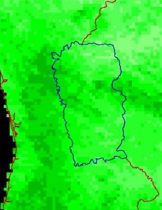
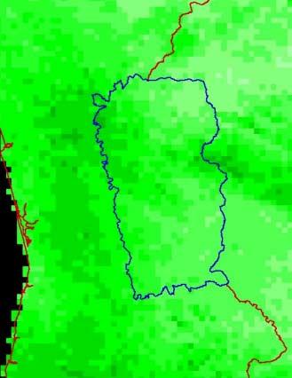
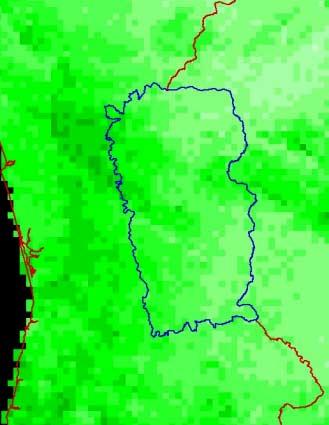
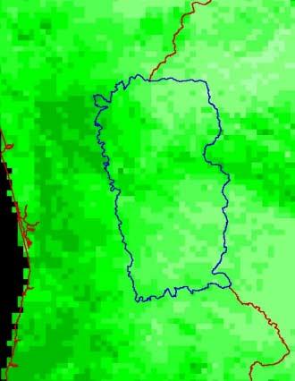
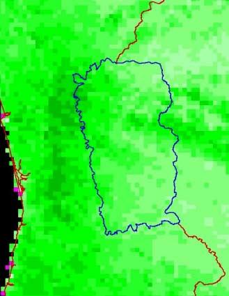
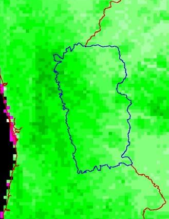
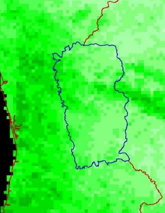
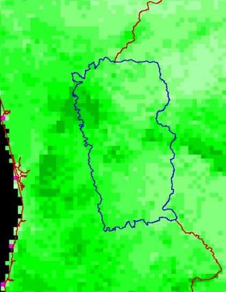
38 Fire Potential Index (FPI) Map 550-m resolution sample July Fire Risk Classes: Low Medium High Very high FPI Values 17
39 Integrated Forest Fire Risk (IFFR) Map 550-m resolution samples July Fire Risk Classes: Low Medium High IFFR Fire Risk Classes 1

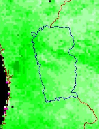
40 Verification & Validation Test Period: 2001 Fire season (June - September) Study Area: Districts: Castelo Branco, Guarda, Viseu, Coimbra e Bragança (665 Freguesias; ha) WRS 203/32 Corresponding to LANDSAT WRS 203/32 Selected for occurrence of numerous and large fires (Approx fires and ha area burned) METHOD: Correlation between fire occurrence and computed indices values 2


41 Burnt Area Map 09/04/ FIRE DATA 11/11/2001 DATA: V & V BURNT AREA MAP 2001 LSAT TM Nov Landsat 5 TM, 9/04/2001 Landsat 7 ETM, 11/11/2001 Ignition points (DGF) METHOD: Change detection in 2001 (MapUp) & visual analysis (RGB 743) RGB 432 RGB 432 RGB 432 3


42 Structural Fire Index vs. Burnt Area SFI Fire Risk Classes Burnt Areas 4
43 Structural Fire Index (SFI) Structural Fire Index (SFI) Study Area (ha) Burnt Areas (ha * 10) Area (ha) SFI SFI Class Class Area (ha) Class Area (%) Burnt Area (ha) Burnt Area (%) Burnt Area/ Total Area (%) High Medium Low Total
44 Fire Density for FPI Fire Density Number Pixels * 1000 (Fires/ Pixels)* Number Pixels Fires / Pixels Fire Potential Index (FPI) 0 6
45 FPI Mean Values Before Fire Day FPI Mean Values Before Fire Days Mean FPI Fire Day - 4 Fire Day - 3 Fire Day - 2 Fire Day - 1 Fire Day Mean FPI STD Days before fire events 7
46 Fire Density for IFFR Fire Density Number Pixels * (Fires/ Pixels)* Number Pixels Fires / Pixels Integrated Fire Risk (IFR) 8
47 IFFR Mean Values Before Fire Day IFFR Mean Values Before Fire Days Mean IFFR Fire Day - 4 Fire Day - 3 Fire Day - 2 Fire Day - 1 Fire Day Mean IFFR STD Days before fire events 9
48 Conclusions Advanced multi-step method to assess daily forest fire risk Integrates proven approaches to combine different data sources Yields several fire risk maps and useful products (RG, Max. Live Ratio, etc.) Some flexibility concerning data requirements Capability to accommodate further improvements Fuel Models (extinction moisture) Optimization of best interpolation methods Identification and inclusion of representative human induced variables 10
49 European Space Agency (ESA) Aknowledgements Joint Research Centre of the European Commission (JRC) Instituto de Meteorologia (IM) Direcção Geral das Florestas (DGF) Robert Burgan (USDA Forest Service, USA) Paulo Barbosa (JRC) Giorgio Libertà (JRC) Ana Sebastian (JRC) José Aranha (UTAD) This research was funded by ESA under the project (ESA Ref. AO/1-3880/01/I-SB). 11
50 - - Prevention and Mitigation of Fire Hazard in Portugal Mário Caetano mario.caetano@igeo.pt Portuguese Geographic Institute, Portugal igeo.pt 12
Automated Fire and Flood Hazard Protection System
 De la Riva, J., Pérez-Cabello, F. & Chuvieco, E. (Eds) 2005 Proceedings of the 5 th International Workshop on Remote Sensing and GIS Applications to Forest Fire Management: Fire Effects Assessment: 167-172
Sensor Placement Algorithm for Rapid Theatre Assessment (SPARTA)
") Sensor Placement Algorithm for Rapid Theatre Assessment (SPARTA) Presented by: Dr Robert Gordon and Dr Martyn Bull Introduction CB Sensors in Collective Protection Strategies Aims of Sensor Placement The
Sensor Placement Algorithm for Rapid Theatre Assessment (SPARTA) Presented by: Dr Robert Gordon and Dr Martyn Bull Introduction CB Sensors in Collective Protection Strategies Aims of Sensor Placement The
Urban Fires & Wildfires November 3, 2009
 Unincorporated Urban Fires & Wildfires November 3, 2009 Plan Update Flanagan & Associates, LLC Consultants Tulsa, OK www.rdflanagan.com rdflanagan@rdflanagan.com Plan can be reviewed at: www.rdflanagan.com/county.html
PRESENTS AQUADUCT AUTOMATED WATER-LEAK MONITORING SYSTEM A KINGPIN TECHNOLOGY
 PRESENTS AQUADUCT AUTOMATED WATER-LEAK MONITORING SYSTEM A KINGPIN TECHNOLOGY INTRODUCING THE INNOVATIVE NEW TECHNOLOGY FOR THE DETECTION OF LEAKS IN WATER NETWORKS. SA WATER CRISIS the rising tide The
Using Remote sensing technique for estimation of real evapotranspiration
 Using Remote sensing technique for estimation of real evapotranspiration Hassan Fathizad, Bijan Azad, Ali Yousefi, Azin jafarian Abstract Evapotranspiration is not easy to measure; Specific devices and
Hydrologic Assessment of using Low Impact Development to Mitigate the Impacts of Climate Change. Chris Jensen, AScT Master of Science Thesis
 Hydrologic Assessment of using Low Impact Development to Mitigate the Impacts of Climate Change Chris Jensen, AScT Master of Science Thesis Bowker Creek Initiative April 12, 2012 Outline 1. Future Impacts
STRUCTURAL HEALTH MONITORING OF UNDERGROUND INFRASTRUCTURE
 STRUCTURAL HEALTH MONITORING OF UNDERGROUND INFRASTRUCTURE SUSOM DUTTA Graduate Student UMass Lowell Co-Authors: Dr. Pradeep Kurup, Dr. Raj Gondle, Mr. Dennis Doherty, Dr. Tzuyang Yu, Dr. Xingwei Wang
NEAR REAL TIME DETECTION OF BURNED SCAR AREA USING LANDSAT-8 IMAGERIES
 NEAR REAL TIME DETECTION OF BURNED SCAR AREA USING LANDSAT-8 IMAGERIES Danang Surya Candra Kustiyo - Indonesian National Institute of Aeronautics and Space (LAPAN) - Outline INTRODUCTION: Background, Problems,
Use of new spatially refined satellite remote sensing fire detection data in support of advanced wildfire mapping and modeling
 Use of new spatially refined satellite remote sensing fire detection data in support of advanced wildfire mapping and modeling Dr. Wilfrid Schroeder 1 Dr. Janice Coen 2 Dr. Patricia Oliva 1 Dr. Louis Giglio
Aquarius - Spectrum. multi-layer acoustic water pipe monitoring solutions. Game changer in water network management
 Aquarius - Spectrum multi-layer acoustic water pipe monitoring solutions Game changer in water network management ID Founded in 2009 20 Employees Invested by Hutchinson Water Over 3,000 correlation sensors
Advanced Fire Information System
 Advanced Fire Information System Karen Steenkamp Philip Frost CSIR Meraka Institute www.sac.co.za Meraka Institute - RSRU RSRU Mission: To conduct basic and applied remote sensing research for the advancement
Preventing Catastrophe: the Firewise Approach to Community Design. Denise Laitinen Firewise Communities Hawaii September 24, 2009
 Preventing Catastrophe: the Firewise Approach to Community Design Denise Laitinen Firewise Communities Hawaii September 24, 2009 What/who is Firewise? Created in 1985 by NFPA & USDA after a horrific fire
Methods to Simulate the Impact of BMPs
 LA221 Project Ortega Watershed Demonstration Area, Quito Ecuador Ricardo da Cruz e Sousa Master of Landscape Architecture & Environmental Planning University of California, Berkeley December 2011 Ortega
R&D for the improvement of O&M in CSP plants. Dr. Marcelino Sánchez. - November,
 R&D for the improvement of O&M in CSP plants. Dr. Marcelino Sánchez - November, 2015 - í n d i c e 1 Need of R&D for O&M improvement in CSP Plants 2 Current R&D activities in O&M improvement carried out
2015 Honeywell Users Group Europe, Middle East and Africa
 2015 Honeywell Users Group Europe, Middle East and Africa Safety System Lifecycle Support and Honeywell s capabilities in Industrial Fire & Gas Johan School, Honeywell (Product Manager Safety Systems)
1.1. SYSTEM MODELING
 1 INTRODUCTION Electro-optical imaging system analysis is a mathematical construct that provides an optimum design through appropriate trade studies. A comprehensive model includes the target, background,
MINISTRY OF THE INTERIOR CHIEF-DIRECTORATE FIRE SAFETY AND CIVIL PROTECTION DISASTERS RESPONSE AND UNIFIED RESCUE SYSTEM
 MINISTRY OF THE INTERIOR CHIEF-DIRECTORATE FIRE SAFETY AND CIVIL PROTECTION DISASTERS RESPONSE AND UNIFIED RESCUE SYSTEM LAW ON THE MoI CHIEF DIRECTORATE FIRE SAFETY AND CIVIL PROTECTION - MoI With the
Strategic Research Agenda for. High-Altitude Aircraft and Airship. Remote Sensing Applications
 Strategic Research Agenda for USE HAAS High-Altitude Aircraft and Airship Remote Sensing Applications Christian Barbier (CSL, B), Bavo Delauré (VITO, B), Arie Lavie (CTI, Is) 1 OUTLINE 1. The USE HAAS
Lesson 11 Internet Connected Environment (Weather, Air Pollution and Forest Fire) Monitoring
 Monitoring") Lesson 11 Internet Connected Environment (Weather, Air Pollution and Forest Fire) Monitoring 1 Environment Monitoring Weather Uses of sensors for T, RH and Patm parameters, WSNs, access points, gateways
Lesson 11 Internet Connected Environment (Weather, Air Pollution and Forest Fire) Monitoring 1 Environment Monitoring Weather Uses of sensors for T, RH and Patm parameters, WSNs, access points, gateways
SEVIRI/MSG sensor early fire detection performances assessment
 SEVIRI/MSG sensor early fire detection performances assessment G. Laneve, E. Cadau CRPSM Università di Roma La Sapienza e-mail: laneve@psm.uniroma1.it 2 nd GOFC/GOLD Workshop on GEO Fire Monitoring, Darmstadt,
Ethanol Tank Fire Fighting
 Ethanol Tank Fire Fighting Goal of ETANKFIRE project Ensure proper investments in fire protection of ethanol storage plants Determine the large scale fire behaviour of ethanol fuels Provide input to computer
Action Recommendation: Budget Impact:
 City of Fayetteville Staff Review Form Tim Nyander Submitted By 2016-0447 Legistar File ID 10/18/2016 City Council Meeting Date - Agenda Item Only N/A for Non-Agenda Item 9/28/2016 Submitted Date Action
Digital soil mapping from legacy data and hyperspectral imagery in CapBon (Tunisia) First results and perspectives.
 First results and perspectives.") Digital soil mapping from legacy data and hyperspectral imagery in CapBon (Tunisia) First results and perspectives. Philippe Lagacherie 1, Cécile Gomez 2, Sinan Bacha 4, Rossano Ciampalini 2, Hedi Hamrouni
Digital soil mapping from legacy data and hyperspectral imagery in CapBon (Tunisia) First results and perspectives. Philippe Lagacherie 1, Cécile Gomez 2, Sinan Bacha 4, Rossano Ciampalini 2, Hedi Hamrouni
FUTURES: Regional Growth Modeling for NC Building a FUTURES Forecasting Model for the Triangle and Rocky Mount Regions
 FUTURES: Regional Growth Modeling for NC Building a FUTURES Forecasting Model for the Triangle and Rocky Mount Regions Presented by: Jeff Michael, RENCI at UNC Charlotte John Vogler, UNCC Center for Applied
New forms of territorial governance for the promotion of landscape policies in the field of water resources management at water
 New forms of territorial governance for the promotion of landscape policies in the field of water resources management at water territories i EU Community Initiative Interreg III B ArchiMed KEPEMEP-MedRegio
ATSTORM v2. The sensor with FCES technology is connected to the interface with a communication cable.
 ATSTORM v2 ATSTORM v2 is a storm detector that measures the environmental electric field. It is fully automatic, without mobile parts, robust and highly reliable The storm detector ATSTORM v2 basic configuration
How keep.eu can be used? Baiba Liepa, Interact Programme
 How keep.eu can be used? Baiba Liepa, Interact Programme What is keep.eu Knowledge management tool including database, website, search engine Available on www.keep.eu The only source of aggregated information
Introduction. Perry Osberg Doug Corbett Adam Parker. President General Manager. Director Business Development. Director Technical Development
 SITEWATCH SOLUTIONS Introduction The principles of SiteWatch Solutions have participated in this environment for more than 25 years developing, designing, deploying and marketing solution sets. Recognizing
PREVENTIVE PROTECTION PROTECCIÓN PREVENTIVA
 PREVENTIVE PROTECTION PROTECCIÓN PREVENTIVA R PREVENTIVE PROTECTION ATSTORM v2 is a storm detector that measures the environmental electric field. It is fully automatic, without mobile parts, robust and
Wireless M2M Solutions
 Wireless M2M Solutions By Edge Power Wireless M2M Solution -Table of Contents Introduction M2M market Position on M2M market M2M Solution (by Edge Power) Deployments in Hong Kong System solution Current
LOCAL STORM DATA SHEET
 LOCAL STORM DETECTION > Storm detection: who is involved? > Regulations, storm phases and classification of detectors > ATSTORM local thunderstorm detector by measurement of electric field > STORM DETECTION:
ENVINET Environmental Radiation Detection
 ENVINET Environmental Radiation Detection Table of content 1 Introduction 2 Solutions and products 3 Our clients ENVINET GmbH Environmental Radiation Detection May 2015 Page 2 Table of content 1 Introduction
GI Standardization Overview
 Second workshop on the use of GIS/OGC standards in meteorology GI Standardization Overview 1 nicolas.lesage@ign.fr 12 Janvier 2009 Modèle TN-02.018-1.1 The goal of standardization According to decree number
Evaluating Chicago s Urban Heat Island Policy with Remote Sensing. Chris Mackey
 Evaluating Chicago s Urban Heat Island Policy with Remote Sensing Chris Mackey The Heat Island Effect When a large urban area is a few degrees warmer than its surrounding rural area. Composed from LANDSAT
1. COOL ROOFS. What is a Cool Roof
 2 COOL ROOFS IN EUROPE: INITIATIVES AND EXAMPLES 1. COOL ROOFS What is a Cool Roof surfaces cool under the sun. This is due to the pro atmosphere. As the roof stays cooler, this reduces the amount of heat
LYNX SE CENTRAL CONTROL FOR NETWORK GDC. General Specifications
 LYNX SE CENTRAL CONTROL FOR NETWORK GDC General Specifications Number of Gateways: Up to 4, each with up to 2 Station Groups Number of decoder stations: up to 500 Number of Courses: 1 Number of holes per
COMMUNITY WILDFIRE PROTECTION PLAN POWELL RIVER REGIONAL DISTRICT
 COMMUNITY WILDFIRE PROTECTION PLAN POWELL RIVER REGIONAL DISTRICT OUTLINE Introduction/Background Information CWPP Planning Structure Brief Overview of the WRMS Results Recommendations/Action Plan INTRODUCTION
Organize your security with PSIM + software
 Organize your security with PSIM + software WHAT IS PSIM SOFTWARE? Functional scope of a Physical Security Information Management System Application In practice, the WinGuard platform is collecting all
PhD Candidate, Université Paris-Est (France) and Institut d Urbanisme de l ALBA - Univerité de Balamand (Lebanon) 2
 and Institut d Urbanisme de l ALBA - Univerité de Balamand (Lebanon) 2") Noushig Kaloustian 1, Youssef Diab 2, Benjamin Bechtel 3, Jürgen Ossenbrügge 3 1 PhD Candidate, Université Paris-Est (France) and Institut d Urbanisme de l ALBA - Univerité de Balamand (Lebanon) 2 Professor,
Noushig Kaloustian 1, Youssef Diab 2, Benjamin Bechtel 3, Jürgen Ossenbrügge 3 1 PhD Candidate, Université Paris-Est (France) and Institut d Urbanisme de l ALBA - Univerité de Balamand (Lebanon) 2 Professor,
A Forest Fire Warning Method Based on Fire Dangerous Rating Dan Wang 1, a, Lei Xu 1, b*, Yuanyuan Zhou 1, c, Zhifu Gao 1, d
 International Conference on Applied Science and Engineering Innovation (ASEI 2015) A Forest Fire Warning Method Based on Fire Dangerous Rating Dan Wang 1, a, Lei Xu 1, b*, Yuanyuan Zhou 1, c, Zhifu Gao
Fire Mapping Chapter. Working Paper
 Fire Mapping Chapter Working Paper Version 1.0 as of September 2018 International Working Group on Satellite-based Emergency Mapping (IWG-SEM) Contents 1. FOREWORD... 3 2. IWG-SEM Fire delineation section...
Smart Wellness. Yoshio Sekiguchi Sr. General manager, Micro Devices H.Q. OMRON Corporation
 Smart Wellness Yoshio Sekiguchi Sr. General manager, Micro Devices H.Q. OMRON Corporation Corporate Overview OMRON s Origins OMRON s history OMRON was established in 1933 as Tateisi Electric Manufacturing
Smart City Governance URBIS Solutions. David Ludlow, Assoc. Professor European Smart Cities University of the West of England, Bristol
 Smart City Governance URBIS Solutions David Ludlow, Assoc. Professor European Smart Cities University of the West of England, Bristol Integrated smart city model Smart Mobility Services focused on decreasing
Development and Full-Scale Tests of a Water Mist System inside High Speed Trains
 Development and Full-Scale Tests of a Water Mist System inside High Speed Trains Prof. J. A. Capote ; Dr. D. Alvear; Dr. M. Lázaro and Dr. O. Abreu GIDAI - UNIVERSITY OF CANTABRIA www.gidai.unican.es Objetives
Integrated urban policies and land management The URBACT Experience Didier Vancutsem
 Integrated urban policies and land management The URBACT Experience Didier Vancutsem Didier Vancutsem URBACT Expert Prof Urban Planner ISOCARP Contents Integrated urban policies and land management: a
The Centron Presidio Monitoring System. Centron. Presidio. Rees Scientific. An ISO 9001:2008 Company
 The Monitoring System Rees Scientific An ISO 9001:2008 Company About Rees Scientific Rees Scientific specializes in protecting your valuable assets. Since 1982, Rees Scientific has been the industry standard
Fire Information for Resource Management System (FIRMS)
") Fire Information for Resource Management System (FIRMS) Diane Davies 1, Chris Justice 1, Jacques Descloitres 2, John Latham 3 John Musinsky 4 1 Department of Geography, University of Maryland 2 SSAI /
Fire Information for Resource Management System (FIRMS) Diane Davies 1, Chris Justice 1, Jacques Descloitres 2, John Latham 3 John Musinsky 4 1 Department of Geography, University of Maryland 2 SSAI /
GCM (~100 km) UCM (~100 m) RCM (~10 km)
 UCM (~100 m) RCM (~10 km)") Urban climate projections for Central European cities and modelling tools for urban planning Maja Žuvela-Aloise NWP Applications, ZAMG, Vienna, Austria GCM (~100 km) UCM (~100 m) RCM (~10 km) Regional
Urban climate projections for Central European cities and modelling tools for urban planning Maja Žuvela-Aloise NWP Applications, ZAMG, Vienna, Austria GCM (~100 km) UCM (~100 m) RCM (~10 km) Regional
LYNX CE CENTRAL CONTROL FOR OSMAC. General Specifications
 LYNX CE CENTRAL CONTROL FOR OSMAC General Specifications Number of satellites: Up to 255 Number of satellite stations: up to 16,320 Number of Courses: 3 Number of holes per course: 48 Number of holes per
Maurice Borgeaud. Directorate of Earth Observation Programmes. Head of Science, Applications and Futures Technologies Department
 Maurice Borgeaud Directorate of Earth Observation Programmes Head of Science, Applications and Futures Technologies Department ESRIN ESA s Earth Observation HQ Personnel on site: ~ 550 Payload operations
Moving to the Cloud: The Potential of Hosted Central Station Services
 Moving to the Cloud: The Potential of Hosted Central Station Services Moving to the Cloud: The Potential of Hosted Central Station Services The global market for alarm monitoring services is expected to
[ [ ADMIN PANEL USER GUIDE
 [ [ ADMIN PANEL USER GUIDE ADMIN PANEL USER GUIDE 2 Contents Logging In & Systems Overview 3 System Details 5 Analytics 6 View Alarms 8 Manage Alarms 9 Create Alarms 10 Device Reporting Alarm 11 Monthly
CaseStudy Climate-ADAPT. Stuttgart: combating the heat island effect and poor air quality with green ventilation corridors
 CaseStudy Climate-ADAPT Stuttgart: combating the heat island effect and poor air quality with green ventilation corridors Cover design: EEA Cover photo: EEA Layout: EEA Legal notice The contents of this
Organize your security with PSIM + software
 Organize your security with PSIM + software WHAT IS PSIM SOFTWARE? Functional scope of a Physical Security Information Management System Application 1 2 4 5 In practice, the WinGuard platform is collecting
ARGUS SERVER SYSTEM. Inspired Systems Pty Ltd 70 Mordaunt Circuit, Canning Vale, Western Australia Ph Fax
 ARGUS SERVER SYSTEM Inspired Systems Pty Ltd 70 Mordaunt Circuit, Canning Vale, Western Australia Ph +618 94565666 Fax +61 8 94565778 ARGUS ARGUS SERVER SYSTEM Overview of Argus ARGUS is an essential,
Session 2: LSA-SAF evapotranspiration: files, format and applications
 Application of remote sensing data for drought monitoring Introduction to EUMETSAT Land SAF products Wednesday November 13, 2013 Session 2: LSA-SAF evapotranspiration: files, format and applications 1.
Description Supervised Wireless Technology PRODUCT SPECIFICATION SHEET
 PRODUCT SPECIFICATION SHEET Made by RSI VIDEO TECHNOLOGIES 2200-XLSP February 2012 Description is a Videofied wireless, battery operated security system. The control panel is designed for residential and
Needs, goals, and pain points addressed
 Story Needs, goals, and pain points addressed Summary The manager at a municipal regulatory agency needs a solution to monitor solar powered municipal waste compactors, that replace classic public waste
Dynamic Performance of the Guarda Footbridge
 Dynamic Performance of the Guarda Footbridge Carlos Rebelo PhD, Assistant Professor, crebelo@dec.uc.pt Hugo Pimenta MSc student, hugo.pimenta@netvisao.pt Luís Simões da Silva Full Professor, lssilva@dec.uc.pt
GIS Training of Undergraduates: Campus Stormwater Mapping. Joanne Logan, University of Tennessee. Gordie Bennett, University of Tennessee
 GIS Training of Undergraduates: Campus Stormwater Mapping Joanne Logan, University of Tennessee Gordie Bennett, University of Tennessee Seth Benge, University of Tennessee Tim Prather, University of Tennessee
Modeling Water Supply Reliability following a major earthquake
 PNWS AWWA May 10, 2013 Modeling Water Supply Reliability following a major earthquake Anne Symonds, PE AECOM David Myerson, PE SFPUC AECOM AGS, A Joint Venture Agenda AWSS and Background Level Of Service
AVOID CATASTROPHIC SITUATIONS: EXPERT FIRE AND GAS CONSULTANCY OPTIMIZES SAFETY
 AVOID CATASTROPHIC SITUATIONS: EXPERT FIRE AND GAS CONSULTANCY OPTIMIZES SAFETY World-class services help reduce incidents, protect the environment, and keep people and plants safe White Paper PAGE 1 Introduction
BMP Siting Tool. Step-by-Step Guide
 BMP Siting Tool Step-by-Step Guide ArcGIS 10.1 Service Pack 1 (Build 3143) Prepared by: Tetra Tech, Inc. 10306 Eaton Place, Suite 340 Fairfax, VA 22030 January 2013 Contents 1 Getting Started... 1 1.1
DEMONSTRATION OF A SEMI-OPERATIONAL FIRE RECOGNITION SERVICE USING BIRD MICRO- SATELLITE - DEMOBIRD
 DEMONSTRATION OF A SEMI-OPERATIONAL FIRE RECOGNITION SERVICE USING BIRD MICRO- SATELLITE - DEMOBIRD Jesús Gonzalo, Gonzalo Martín de Mercado Ingeniería y Servicios Aeroespaciales, S.A. (INSA), Spain Paseo
Mika Peace. August 2013
 Fire Advanced Forecasters Course 2013 Bushfire CRC Bureau of School of Mathematical Sciences, Adelaide University August 2013 Acknowledgements Fire Thanks to: Graham Mills Lachie McCaw Trent Mattner Jeff
SOLAR HOT WATER AND HEAT PUMP BOOSTER ENERGY CALCULATION METHODOLOGY
 SOLAR HOT WATER AND HEAT PUMP BOOSTER ENERGY CALCULATION METHODOLOGY PART A: CALCULATION METHODOLOGY FOR SOLAR WATER HEATERS AND HEAT PUMP WATER HEATERS WITH A VOLUMETRIC CAPACITY OF UP TO AND INCLUDING
Software Solutions FOR THE TELECOMMUNICATIONS INDUSTRY CTS ALARM SOLUTION
 Software Solutions CTS ALARM SOLUTION Accommodates Multiple Sessions Connects to Leading Switch Manufacturers Long-Term Storage of Data Streams Easy to Use Reports Customizable Notification System With
MICROPOINT to MICROPOINT II UPGRADE
 MICROPOINT to MICROPOINT II UPGRADE Why is INTREPID II an intelligent upgrade choice for my customer?. II is highly scalable and can be easily configured to address a range of security requirements, site
Evaluating Low Impact Development Practices for Stormwater Management on an Industrial Site in Mississippi
 Evaluating Low Impact Development Practices for Stormwater Management on an Industrial Site in Mississippi Dennis S. Painter, Tennessee Valley Authority, Nashville, Tennessee Donald Becker, Tennessee Valley
Automating Heat Detection Dr. Edmond Harty. Abstract. Technical director, Dairymaster, Causeway, Co. Kerry, Ireland.
 Automating Heat Detection. Technical director, Dairymaster, Causeway, Co. Kerry, Ireland. Abstract This paper describes the development of the Dairymaster MooMonitor which is a new nanotechnology accelerometer
Real Time Pipeline Leak Detection on Shell s North Western Ethylene Pipeline
 Real Time Pipeline Leak Detection on Shell s North Western Ethylene Pipeline Dr Jun Zhang & Dr Ling Xu* REL Instrumentation Limited ABSTRACT In the past ten years, a number of pipeline leak detection systems
Chapter 1 Introduction
 Chapter 1 Introduction This chapter presents an introductory background to the research work undertaken, the problem statement, research issues involved and objectives of the research work. The contribution
Long-term Inventory of Fire Burned Areas and Emissions of North America s Boreal and Temperate Forests
 Long-term Inventory of Fire Burned Areas and Emissions of North America s Boreal and Temperate Forests P.Gong, Z. Li, I. Csiszar, W. Hao, R. Fraser J.Z. Jin, R. Pu Objectives 1. Map burn scars in boreal
Strategic Environmental Assessment Screening Report. Dublin Port Masterplan Review 2017
 Strategic Environmental Assessment Screening Report Dublin Port Masterplan Review 2017 Table of Contents 1 Introduction... 1 2 Purpose of the Masterplan... 2 3 Task 1.1 Pre-Screening Check... 5 4 Task
Being Prepared and Providing Situational Awareness, through the use of Web GIS
 Being Prepared and Providing Situational Awareness, through the use of Web GIS Captain Michael Brady, Commanding Officer GIS Unit, Fire Department City of New York Who We Are 11,198 Firefighters and Fire
Substation Monitoring System
 Substation Monitoring System SF6 Gas Density Monitoring System Description Introduction As a result of recent European legislation on the control of greenhouse gasses, utilities and manufacturers alike
Water Resources and Policy Initiatives CSU Campus Water Use Calculations Standard Operating Procedures February 26, 2016
 Water Resources and Policy Initiatives CSU Campus Water Use Calculations Standard Operating Procedures February 26, 2016 Project Background California State University (CSU) campuses face a challenge in
Reality Check Workshop Adaptation on the ground in Istanbul. April Istanbul-Turkey
 Reality Check Workshop Adaptation on the ground in Istanbul April 2018 Istanbul-Turkey Istanbul Total Area 5.345 Km² Urban Area %26,2 Lakes %2,4 Forests %45,15 Agricultural Area %26,25 15 Million Population
CleanSeaNet First Generation. 16 April January 2011
 CleanSeaNet First Generation 16 April 2007-31 January 2011 Cover photo credits: European Space Agency (http://www.esa.int) All maps and tables generated by EMSA based on CleanSeaNet data CleanSeaNet First
5. Land use database applications
 48 Towards an urban atlas 5. Land use database applications The Murbandy/Moland project is a continuously evolving activity. To date, the territorial data sets have been completed and validated for 25
Wildland fire phenomenology experiments:
 Wildland fire phenomenology experiments: 2001-2002 RIT: Bob Kremens Stef VanGorden Andy Fordham Bryce Nordgren Dave Pogolarza Adam Cisz RMSC: Dan Latham Colin Hardy Brett Butler We plan to measure unknown
AVOID CATASTROPHIC SITUATIONS: EXPERT FIRE AND GAS CONSULTANCY OPTIMIZES SAFETY
 AVOID CATASTROPHIC SITUATIONS: EXPERT FIRE AND GAS CONSULTANCY OPTIMIZES SAFETY World-class services help reduce incidents, protect the environment, and keep people and plants safe White Paper PAGE 1 Introduction
6 th Pipeline Technology Conference 2011
 6 th Pipeline Technology Conference 2011 Pipeline Leak Detection and Theft Detection Using Rarefaction Waves Authors: Dr Alex Souza de Joode, VP International Operations; ATMOS International, UK. Andrew
Using Traffic Simulation for Emergency and Disaster Evacuation Planning
 Using Traffic Simulation for Emergency and Disaster Evacuation Planning Oscar Franzese National Transportation Research Center Oak Ridge National Laboratory Lee Han National Transportation Research Center
Earth Observation & GeoSpatialBig Data for Monitoring SDG Indicators
 Earth Observation & GeoSpatialBig Data for Monitoring SDG Indicators Yifang Ban, Professor Director, Division of Geoinformatics Vice Chair, Department for Urban Planning and Environment KTH Royal Institute
How to Use Fire Risk Assessment Tools to Evaluate Performance Based Designs
 How to Use Fire Risk Assessment Tools to Evaluate Performance Based Designs 1 ABSTRACT Noureddine Benichou and Ahmed H. Kashef * Institute for Research in Construction National Research Council of Canada
Optical Fiber Monitor (OFM) Whitebox WB-OFM-1262-DC
 Whitebox WB-OFM-1262-DC") Optical Fiber Monitor (OFM) Whitebox WB-OFM-1262-DC www.lumentum.com Data Sheet The Lumentum Optical Fiber Monitor (OFM) Whiteboxes reduce network downtime with automated fault location. Detecting and
Optical Fiber Monitor (OFM) Whitebox WB-OFM-1262-DC www.lumentum.com Data Sheet The Lumentum Optical Fiber Monitor (OFM) Whiteboxes reduce network downtime with automated fault location. Detecting and
Alternative Crop Suitability Methodology
 Alternative Crop Suitability Methodology The Alternative Agriculture in Missouri Hub on Community Commons includes model-based ratings of natural suitability for selected alternative crops. These ratings
Approval to Use $76,105 of Fire Warden Public Facilities Fees (PFF) Funding for the Purchase of a Regional Fire Records Management System
 Funding for the Purchase of a Regional Fire Records Management System") THE BOARD OF SUPERVISORS OF THE COUNTY OF STANISLAUS ACTION AGENDA SUMMARY DEPT: CEOOffice of Emergency SrvcsIFire Warden BOARD AGENDA # Urgent AGENDADATE *B9 November 30,2010 CEO Concurs with Recom 415VoteRequired
THE BOARD OF SUPERVISORS OF THE COUNTY OF STANISLAUS ACTION AGENDA SUMMARY DEPT: CEOOffice of Emergency SrvcsIFire Warden BOARD AGENDA # Urgent AGENDADATE *B9 November 30,2010 CEO Concurs with Recom 415VoteRequired
DETECTION AND MONITORING OF ACTIVE FIRES USING REMOTE SENSING TECHNIQUES
 DETECTION AND MONITORING OF ACTIVE FIRES USING REMOTE SENSING TECHNIQUES Source: Unknown n.d., http://www.hotrodsandclassics.net/featuredpictures/featurepictures2.htm. by Claire Riddell DETECTION AND MONITORING
Using VIIRS Direct Readout Capabilities for the Improvement of Mexico's Wild Fire Alert System
 Using VIIRS Direct Readout Capabilities for the Improvement of Mexico's Wild Fire Alert System Juan M. Escamilla Mólgora 1 National Commission for Knowledge and Use of Biodiversity CONABIO - Mexico 1 CSPP/IMAPP
XERIC. Prof. Dr. Ing. Gilbert M. Rios Head WP5 / Dissemination - Communication
 XERIC Prof. Dr. Ing. Gilbert M. Rios Head WP5 / Dissemination - Communication This project has received funding from the [European Union s Horizon 2020 research and innovation programme under grant agreement
EARLINET products for model evaluation and assimilation
 EARLINET products for model evaluation and assimilation Ioannis Binietoglou and EARLINET 1 National Observatory of Athens, Greece 2 National Institute for R&D in Optoelectronics, Romania 2 EARLINET research
Keren Kayemeth LeIsrael Jewish National Fund KKL-JNF
 Keren Kayemeth LeIsrael Jewish National Fund KKL-JNF Forestry & Woodland Fire Detection & Management Systems Request for Information (RFI) Date: 5-07-2013 1 Request for Information (RFI) Forestry & Woodland
Study and development of an innovative 3G/4G wireless network analysis tool
 University of TRENTO - Faculty of Engineering Master of Science in Telecommunications Engineering Study and development of an innovative 3G/4G wireless network analysis tool Advisors Prof. Andrea MASSA
D Implementation of a DEMO system related to Smart Fault Management in LV network (normal/storm conditions)
") D 4.5.11 1 (13) D 4.5.11 Implementation of a DEMO system related to Smart Fault Management in LV network (normal/storm conditions) Version 1.0 Created: 2013-2-27 By: Joni Aalto, Empower IM Oy Jan Segerstam,
D 4.5.11 1 (13) D 4.5.11 Implementation of a DEMO system related to Smart Fault Management in LV network (normal/storm conditions) Version 1.0 Created: 2013-2-27 By: Joni Aalto, Empower IM Oy Jan Segerstam,
Seminar on Standardisation in Research and Innovation Practical tools for the dissemination and implementation of research results
 Seminar on Standardisation in Research and Innovation Practical tools for the dissemination and implementation of research results Brussels - 10 th November 2011 - Louis-Guy CAJOT DIFISEK & DIFISEK + DIssemination
Experion LX Direct Station Specification
 Technical Information Experion LX Direct Station Specification LX03-210-110 Release 110 January 2014, Version 1 Experion LX Station Specification, LX03-210-110 Revision History Revision Date Description
Global Biomass Burning Emissions from a Constellation of Geostationary Satellites for Global Model Forecast Applications
 1 Global Biomass Burning Emissions from a Constellation of Geostationary Satellites for Global Model Forecast Applications Shobha Kondragunta NOAA/NESDIS Center for Satellite Applications and Research
Crop Management Details Start from Parameters settings Emergence Planting Seed brand: Settings Parameter settings Hybrid-specific Generic
 2.3.4. Crop Management Details Start from: A Hybrid-Maize simulation can start from either planting or emergence. Make that choice and select the appropriate date from the month/date boxes on the right.