The Western Ring Route Three Steel Bridges Auckland
|
|
|
- Melinda Horn
- 5 years ago
- Views:
Transcription


1 REF54 111


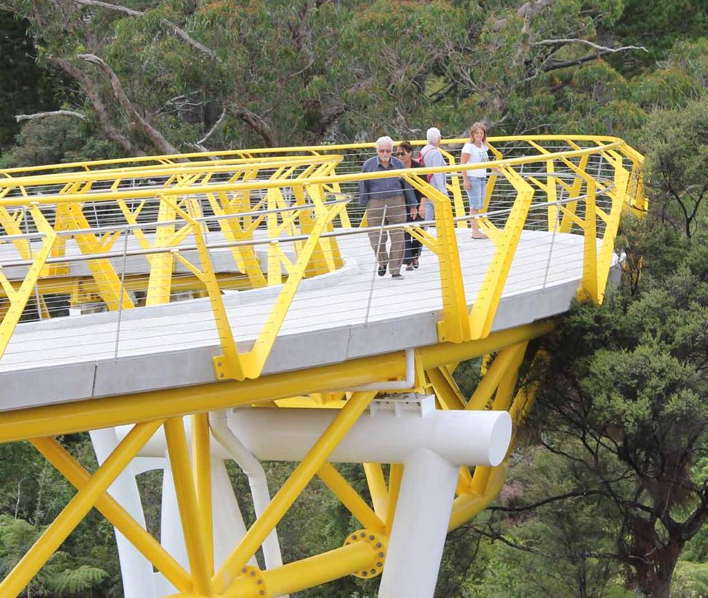
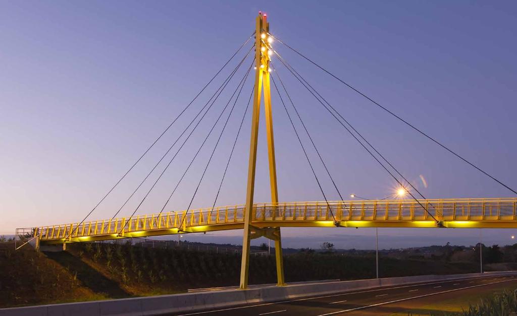
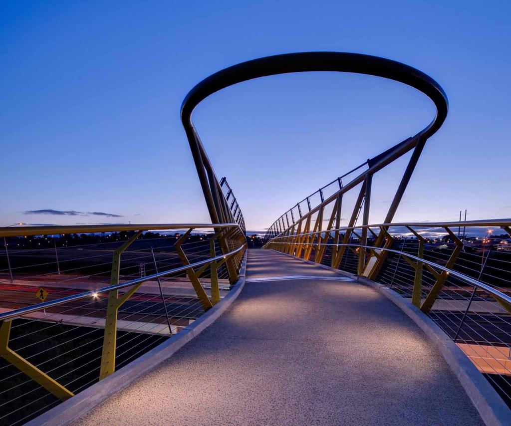
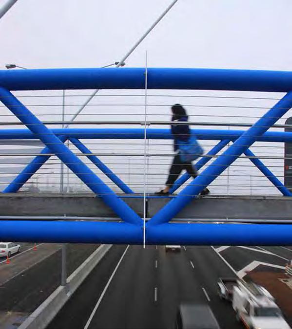
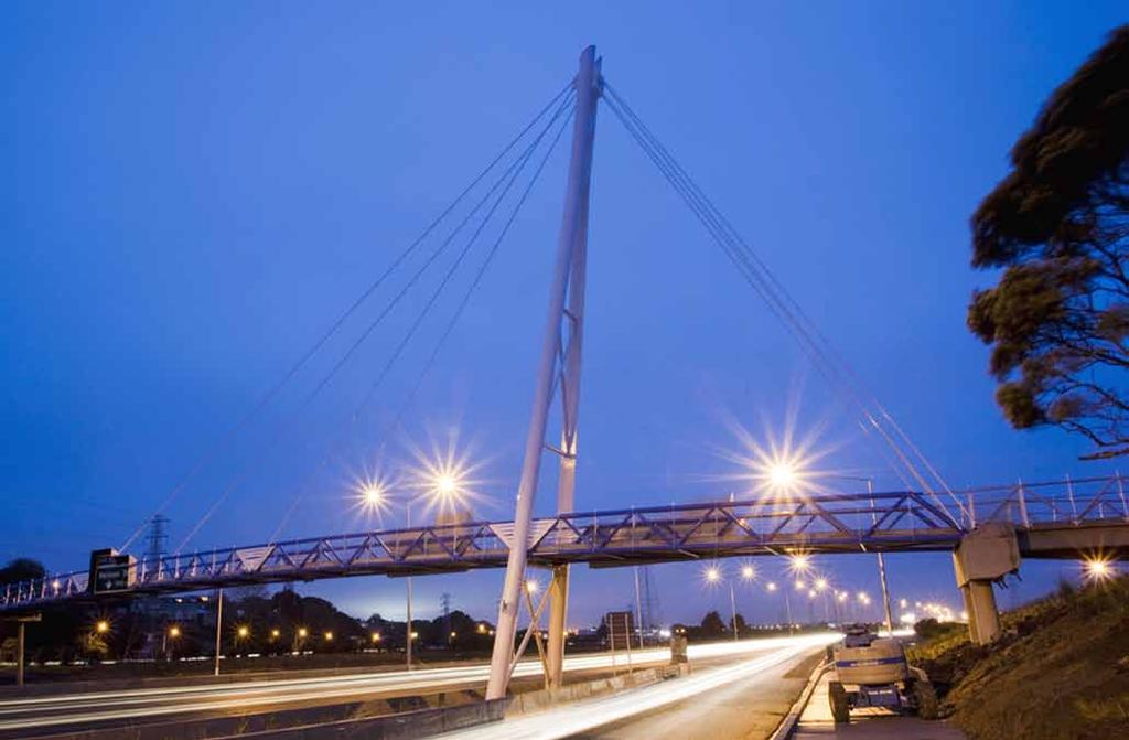
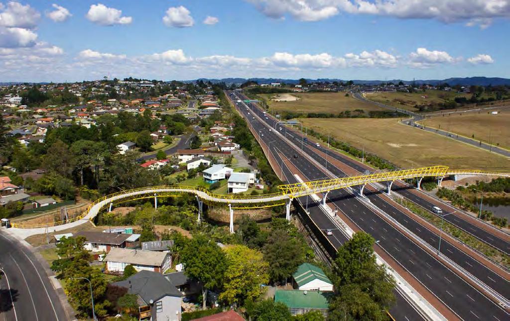
2 The Western Ring Route Three Steel Bridges Auckland Jasmax has been fortunate enough to provide design services along the Western Ring Route, with the Waterview Connection being the final linkage in this suite of projects. Jasmax has provided design services for the SH20-1 Manukau Extension, the SH20 Manukau Harbour Crossing and the SH16/18 Hobsonville Deviation. Part of the urban design strategy was to provide moments along the journey to provide legibility and place making in partnership with site specific treatments of other elements such as plantings, noise attenuation and retaining walls etc. Jasmax has been instrumental in bringing colour into NZTA projects through these bridges and others. The choice of steel for the structure and secondary elements of the bridges brings with it the need for protection from corrosion and the opportunity to use brightly coloured coatings performing this function. These pedestrian and cycle bridges reconnect communities severed by the motorway. That they perform this function in a colourful way helps humanise the motorway itself and provides links to, and markers for, the communities they serve. Because of the relatively light loading of such bridges (compared with overbridges carrying heavier vehicular loads) a greater degree of structural freedom is possible. In many of the projects making up the Western Ring Route, the footbridges become the feature bridge and punch well above their weight in terms of their cost, often about 1% of the total cost of a typical 5-10km stretch of motorway construction. The Beachcroft Footbridge in Onehunga was constructed as part of the SH Manukau Harbour Crossing project. An existing concrete footbridge could not be modified to span the additional lanes of the widened motorway. The new bridge was designed to current standards, including 3.5 metre width to safely accommodate cyclists and pedestrians, and integrate into the landscape design of the Onehunga foreshore park. The asymmetrical steel cable stayed bridge structure was designed to respond to the site topography and as a counterpoint to the plethora of power pylons in this coastal site. The Westgate Footbridge was designed to satisfy the pressing need for a safe direct link across the widened SH16 motorway near the Westgate Centre and Hobsonville Road. This 200 metre long bridge comprises of a straight section angling across the motorway and a reverse curving roller coaster section across a stream to Oreil Avenue. The curvilinear route was a solution to the height difference between these two points. This section of the bridge is supported by an underslung triangular truss, while the motorway crossing employs trussed sides which increase in height toward either end. The Clarks Lane Footbridge reconnects the Clarks Lane across the new SH18 Hobsonville Deviation motorway leading to the Upper Harbour Crossing. Placed on a straight section of the motorway, it acts as a colourful entry marker to West Auckland from the north. Subtle lighting of the structure ensures that the colour is enhanced at night. Both the Beachcroft and Clarks Lane Footbridges have received NZ Institute of Architects Awards in the Urban Design category.

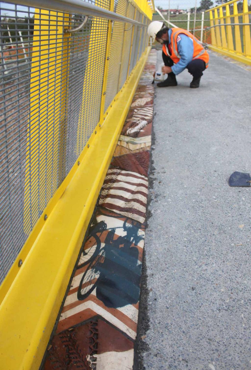
3 REF54 Contrary to rumour, the Beachcroft Footbridge was not painted blue and white to remind visitors coming from the airport that they were entering Auckland Blues territory. Rather, the proximity to the Manukau Harbour foreshore was an influence in selecting the cable stayed structural solution. White was therefore chosen as the appropriate colour for the tall, raked pylon and stays, with their nautical appearance. The structure is a hybrid in the sense that the main span of the new bridge had to be erected in a few hours of overnight motorway closure. This tubular steel truss element supports its own weight; the cables were added later to support the precast concrete decking and live loads. To celebrate their role in the structure, the main span and the back span were painted Resene Fun Blue, also reflecting the nearby harbour. The Westgate Footbridge s yellow superstructure carries on the use of Resene Moon Yellow established on the earlier Clarks Lane Footbridge, a few kilometres away. The reasoning for this was to link the bridges as they perform similar functions on the same motorway network, despite each bridge having a very different appearance. At Westgate, the yellow is used for all of the superstructure, including the distinctive V-shaped barrier stanchions. However the piers are contrasted in white, to allow the long yellow structure to float above. This bridge also has a stainless steel mesh throw screen fixed between steel supports which are welded to the top chord of the truss, carrying on the line of the diagonals. These were painted grey, Resene Dune, in order to not detract from the strong form of the yellow truss. One of the urban design drivers for the Hobsonville Deviation project was the notion of it as The Gallery Route incorporating public art as well as recognising the early clay industries based in the area. Accordingly, Clarks Lane was designated as the Clay Carpet using site specific artwork both integrated into the bridge itself and as larger works in the approach pathways. Yellow was determined to be the most appropriate 113 colour to both stand out in the motorway landscape and to symbolise the historic association with clay. Purpose made ceramic tiles border the concrete bridge deck, with the larger works off the bridge still being completed by the ceramic artists. The all-encompassing yellow of the bridge steelwork is set off by a polished stainless steel handrail (as is the case with all three of these bridges) and zinc-aluminium self-finished safety mesh. These three bridges have opened over the last three years. Introducing colour into the motorway network presents challenges, as the requirements of maintenance, longevity and graffiti protection are important. Grey is seen as an easy default option. The use of thermal spray zinc epoxy urethanes supplied by Resene Group company, Altex Coatings, has provided an excellent solution to corrosion protection with great colours and a high degree of gloss which affords the level of graffiti protection required by NZTA. All three bridges provide a major step forward, especially to a public used to galvanised finishes on these structures.

4 114

5 REF54 115


6 Resene Submerge Architectural specifier: Jasmax Bridge engineer - Beachcroft Footbridge: Andrew Dickson & Melanie Regino, Beca Bridge engineer - Clarks Lane Footbridge: Tom Pang & Ben Ryder, Aurecon Bridge engineer - Westgate Footbridge: John McNeil & Oliver de Lautour, Aurecon Building contractor - Beachcroft Footbridge: NZTA/Fletcher/Beca/Higgins Alliance Building contractor - Clarks Lane Footbridge and Westgate Footbridge: HEB Construction Client: New Zealand Transport Agency (NZTA) Colour selection: Jasmax Painting contractor - Beachcroft Footbridge: TBS Coatings Ltd Painting contractor - Clarks Lane Footbridge: Napier Sandblasting Co Ltd Painting contractor - Westgate Footbridge: Auckland Abrasive Blasting & Coatings Ltd 116
SH20 Manukau Harbour Crossing Project Notice of Requirement Auckland City Council
 19 May 2006 (Updated 28 August 2006) Notice of Requirement Dated 19 May 2006: Updated 28 August 2006 Notice of Requirement Dated 19 May 2006: Updated 28 August 2006 Page i Form 18 Notice of Requirement
Section C Bridges and retaining walls
 Section C Bridges and retaining walls Above: This existing bridge on SH2 at Tauranga has a simple tapered column form that is a good precedent for the TEL. The open abutment optimises views along the highway
6 BRIDGES. 6.1 Design philosophy. Proposed bridges
 SECTION 6 BRIDGES 6 BRIDGES Throughout the Project, bridges are a key visual element and marker for road users, pedestrians and cyclists. The design of bridges, as with other visible structures, has been
DESIGN OF FOOTBRIDGES
 Civil Engineering Technical Requirement CIVIL-SR-006 DESIGN OF FOOTBRIDGES Revision: 9 Updated: 26/08/2015 Queensland Rail 2015 Reproduction by any means (including electronic, mechanical, photocopying,
Great Lakes North Central South Central FAX: (718) CONTACT PERSON: ADDRESS: Daniel Hom, PE, Engineer-in-Charge
 CONTACT PERSON: ADDRESS: Daniel Hom, PE, Engineer-in-Charge") AMERICAN SOCIETY OF HIGHWAY ENGINEERS National Project of the Year Award OFFICIAL ENTRY FORM AWARD CATEGORY (Check One): Under $20 Million Over $20 Million SPONSORING REGION (Check One): Northeast Mid-Atlantic
AMERICAN SOCIETY OF HIGHWAY ENGINEERS National Project of the Year Award OFFICIAL ENTRY FORM AWARD CATEGORY (Check One): Under $20 Million Over $20 Million SPONSORING REGION (Check One): Northeast Mid-Atlantic
Design of Movable Bridges - selected examples
 Design of Movable Bridges - selected examples Adriaan Kok Designer, Project Manager ipv Delft Delft, The Netherlands adriaankok@ipvdelft.nl Niels Degenkamp Designer, Project Manager ipv Delft Delft, The
(blank page) WestConnex New M Roads and Maritime Services Environmental impact statement
 WestConnex New M Roads and Maritime Services Environmental impact statement") (blank page) WestConnex New M5 5-42 (blank page) WestConnex New M5 5-44 5.5 Tunnels 5.5.1 Main alignment tunnels The main alignment tunnels would be about nine kilometres long, with the western tunnel
(blank page) WestConnex New M5 5-42 (blank page) WestConnex New M5 5-44 5.5 Tunnels 5.5.1 Main alignment tunnels The main alignment tunnels would be about nine kilometres long, with the western tunnel
Views from the Bridge
 Chapter 2 Views from the Bridge Alternative 2A would primarily have adverse visual impacts to views from the Bridge, with the exception of a strongly adverse visual impact from Viewpoint 11 (Car View East)
REAAA NZ Chapter 2012 Roadshow Auckland 15 August
 REAAA NZ Chapter 2012 Roadshow Auckland 15 August AMETI Package 2: Sylvia Park Bus Lanes Jem Gilbert BSc (hons), CEng (UK), FICE Technical Director Transportation Major Projects Content of Today s Presentation
Victoria Bridge Municipal Class EA Civic Works Committee
 Municipal Class EA John Pucchio, P. Eng., Project Manager June 19 2018 Introduction Existing Conditions Municipal Class EA Proposed Bridge Proposed Road Reconstruction Proposed Improvements Construction
2.0 Urban Design Concepts
 0 Urban Design Concepts Urban Design Concept diagrams The Waterfront Axis The Park Axis The Wharf Axis Waterfront Precincts 0.1 The Four Key Concepts: This Concept for the Wynyard Quarter establishes four
GLEN ROAD PEDESTRIAN BRIDGE ENVIRONMENTAL ASSESSMENT STUDY PUBLIC INFORMATION CENTRE #2 OCTOBER 24, 2017
 GLEN ROAD PEDESTRIAN BRIDGE ENVIRONMENTAL ASSESSMENT STUDY PUBLIC INFORMATION CENTRE #2 OCTOBER 24, 2017 Glen Road Pedestrian Bridge Class Environmental Assessment 1 WELCOME! Welcome to the second Public
Temporary Bridging. Issue 2
 Temporary Bridging Issue 2 Welcome to Mabey Operating from 17 depot locations across England, Scotland and Wales, we combine full UK coverage with localised depot solutions. We have decades of extensive
AMBLESIDE WATERFRONT
 Overview: An Integrated Vision for the Waterfront The waterfront concept plan shown above is the result of 40 years of acquiring, planning and improving a publicly-owned waterfront. Consistent community
Hovenring Eindhoven. A bridge designed for the requirements involving all disciplines and stakeholders. Adriaan Kok
 Hovenring Eindhoven A bridge designed for the requirements involving all disciplines and stakeholders Adriaan Kok ipv Delft creative engineers mail: adriaankok@ipvdelft.nl website: ipvdelft.nl or ipvdelft.com
Urban and Landscape Design Frameworks Highways and Network Operations Guideline
 Urban and Landscape Design Frameworks Highways and Network Operations Guideline The following outlines the process to be followed through the planning, design and construction phases of a state highway
Option A FINAL AESTHETIC SIGNATURE BRIDGE PROPOSAL. SR 836/I-395/I-95 Project
 ELECTRONIC COPY AESTHETIC VOLUME 2 2.28.17 APPROVED SIGNATURE BRIDGE PACKAGE, APTES, AND SIGNATURE BRIDGE RELATED ATCS SR 836/I-395/I-95 Project Florida Department of Transportation District 6 & Miami-Dade
Tauranga City Centre Spatial Framework
 Tauranga City Centre Spatial Framework Stakeholder Engagement Workshop 15 October 2015 Project Design Team Beca & LandLAB Our team Henry Crothers (LandLab) Landscape Architect/Urban Designer Urban and
SH1 - Causeway, Auckland, 2014 (Source: NZ Transport Agency)
") SH1 - Causeway, Auckland, 2014 (Source: NZ Transport Agency) Coastal effects assessment guide Environmental and social responsibility policy State highway environmental plan Transport Agency statement
SH1 - Causeway, Auckland, 2014 (Source: NZ Transport Agency) Coastal effects assessment guide Environmental and social responsibility policy State highway environmental plan Transport Agency statement
Floodlights. In this section.
 In this section 5.1 s 5.3 Metal Halide Floodlights 5.3 High Pressure Sodium Floodlights 5.4 Energy Saver Floodlights 5.4 LED Floodlights www.ecolifelighting.co.nz Floodlights Floodlights Floodlighting
ROAD AND CAR PARK DESIGN GUIDELINES
 3.2 ROAD AND CAR PARK DESIGN GUIDELINES PIHA AREA DESIGN GUIDELINES AUCKLAND REGIONAL COUNCIL 37 Existing Road and Car Park Photos: North Piha carpark Anawhata carpark Winstone Track carpark off Piha Road
TRAFALGAR PLACE LONDON
 January 2017 Uniclass L534:L217 Award-winning and Stirling Prize shortlisted Urban regeneration high density housing scheme Exemplary public realm with precast concrete paving Careful detailing carried
Historic Bridge Foundation Facebook Archives
 Historic Bridge Foundation Facebook Archives Focus Bridges: Firth of Forth Bridges September 2017 The Firth of Forth in Scotland is a unique location perhaps one of the only locations in the world where
CALGARY CULTURAL DISTRICT
 CALGARY CULTURAL DISTRICT a f r a m e w o r k f o r t h e f u t u r e The Calgary Cultural District Project was initiated by the Calgary Performing Arts Center in early 2000, as a means of building on
PART C DESCRIPTION OF THE PROJECT
 PART C DESCRIPTION OF THE PROJECT 6.0 Description of the Project Overview This section includes the Project Description which provides the basis for the assessment of effects on the environment in Part
Chapter 10 Route window W17 Middlegreen Road, St Mary s Road and Trenches bridges. Transport for London
 Chapter 10 Route window W17 Middlegreen Road, St Mary s Road and Trenches bridges Transport for London MIDDLEGREEN ROAD, ST MARY S ROAD AND TRENCHES BRIDGES 10 Route window W17 Middlegreen Road, St Mary
HOOLE ROAD BRIDGE PEDESTRIAN IMPROVEMENT AND FOOTBRIDGE FEASIBILITY REPORT
 HOOLE ROAD BRIDGE PEDESTRIAN IMPROVEMENT AND FOOTBRIDGE FEASIBILITY REPORT December 2008 FEASIBILITY REPORT BRIDGE NAME: HOOLE ROAD BRIDGE CONTENTS Page No 1. EXECUTIVE SUMMARY...1 2. INTRODUCTION...2
10 Proposed Redevelopment, Tewkesbury Road, Cheltenham SCHEME EVOLUTION STARBUCKS
 SCHEME EVOLUTION STARBUCKS The proposed Starbucks Drive Thru alongside the proposed food store provides an appropriate mix of uses, suitable for this location. The proposed store is bespoke, designed specifically
Newsletter. Work underway on major east Auckland transport project. Update: Pakuranga to Botany Busway information day.
 Whats nside? Newsletter Mountain Road bridge replacement Auckland Manukau Eastern Transport nitiative. AMET MARCH 2012 Panmure transport upgrades Work underway on major east Auckland transport project
5.7.6 St Peters Interchange Portal
 5.7.6 St Peters Interchange Portal Design intent At St Peters interchange the design approach to the tunnel portals differs from that adopted for the western portals at Kingsgrove. An entirely different
97 Lea Bridge Road, Leyton, E10 7QL London Borough of Waltham Forest December 2015
 97 Lea Bridge Road, Leyton, E10 7QL London Borough of Waltham Forest December 2015 Public Realm and Landscape Proposals LEA BRIDGE ROAD, WALTHAMSTOW Public Realm & Landscape Proposals BDP(90)RPT001 December
NATURAL HABITATS Expression of Interest Green Screens
 NATURAL HABITATS Expression of Interest Green Screens 2017 PAGE 2 NATURAL HABITATS HAS A proven track record for producing innovative and award winning design solutions Over 100 highly skilled friendly
Pedestrian Project Award Institute of Transportation Engineers
 Pedestrian Project Award Institute of Transportation Engineers Rideau Canal Pedestrian Crossing Planning and Environmental Assessment Report The Setting The Rideau Canal and its adjacent pathways are highly
CAMBRIDGE SOUTHERN FRINGE
 P A V I N G CASE STUDY January 2015 Uniclass L534:L217 Award-winning design New urban communities Master-planning and design codes Permeable and conventional paving CAMBRIDGE www.paving.org.uk Cover Photos:
Figure 3-1: Public Realm Plan
 3 Public Realm Figure 3-1: Public Realm Plan 3.1 Public Realm Concept The public realm concept for the Little Mountain site integrates a clear and accessible movement network with public spaces for social
Visitor's Guide to Historic Bridge Park
 Visitor's Guide to Historic Bridge Park Located in Calhoun County, Michigan, southeast of Battle Creek, the park is open year-round from 8:00 AM to 8:00 PM. Entry to the park is free of charge. Guide produced
Introduction to MP3. MP3 H4 Park Central (North)
") MP H4 Park Central (North) Introduction to MP A visualisation of the Illustrative Masterplan with MP shaded in blue MP is the third phase of the Elephant Park regeneration and is bounded by on the north,
MP H4 Park Central (North) Introduction to MP A visualisation of the Illustrative Masterplan with MP shaded in blue MP is the third phase of the Elephant Park regeneration and is bounded by on the north,
Welcome. Community Consultation Meeting November 28, Review and discuss the Bathurst Quay Neighbourhood Plan Framework
 Welcome Community Consultation Meeting November 28, 2016 Why Are We Here Today? Review and discuss the Bathurst Quay Neighbourhood Plan Framework Review and discuss an Action Plan for Implementation Next
BOLD. BEGUILING. BEAUTIFUL.
 BOLD. BEGUILING. BEAUTIFUL. INSPIRED BOUTIQUE TERRACE RESIDENCES Revered architects Ink present this collection of six boutique torrens title terrace homes which reference the area s industrial past in
Important Forces. Distance Range. Design Features. Suspension Bridge. Truss Bridge. Beam Bridge. Bridge Type. Arch Bridge
 Bridge Type Beam Bridge Truss Bridge Arch Bridge Suspension Bridge Design Features Distance Range Important Forces Last name: First name: Date: Period: BRIDGES INTRO Welcome to Craggy Rock! COM INC COM*
Gloucester Park was once an open sea basin
 1862 - Gloucester Park was once an open sea basin It was filled in as a rubbish tip, used as an army base and a speedway The area has been highly modified by reclamation and roading Allotments for sale
KING-SPADINA SECONDARY PLAN
 16 KING-SPADINA SECONDARY PLAN 16. KING-SPADINA SECONDARY PLAN 1. INERPREAION 1.1 he lands affected by this Secondary Plan for the King-Spadina Area are shown on Map 16-1. 1.2 Where a building within a
Site Option 3: Te Matai
 Site Option 3: Te Matai Location Napier Drain looking south east Description The Te Matai growth option is located between the existing residential boundary (Ruamahanga Crescent) Napier Road (State Highway
Section Three, Appendix 16C Medium Density Housing, Design Assessment Criteria (Residential 8A zone)
") APPENDIX 16C MEDIUM DENSITY HOUSING, DESIGN ASSESSMENT CRITERIA (RESIDENTIAL 8A ZONE) PURPOSE OF APPENDIX 16C (RESIDENTIAL 8A ZONE) In the Residential 8A Zone the following are defined as restricted discretionary
APPENDIX 16C MEDIUM DENSITY HOUSING, DESIGN ASSESSMENT CRITERIA (RESIDENTIAL 8A ZONE) PURPOSE OF APPENDIX 16C (RESIDENTIAL 8A ZONE) In the Residential 8A Zone the following are defined as restricted discretionary
Uniclass L442 CI/SfB (34) X. Architectural Handrail and Balustrade. Architectural metalwork systems
 X. Architectural Handrail and Balustrade. Architectural metalwork systems") Uniclass L442 CI/SfB (34) X Architectural Handrail and Balustrade Architectural metalwork systems Contents Welcome 2-3 Balustrade specifications 4-5 Polyester powder coated 6-7 Stainless steel 8-9 Structural
Uniclass L442 CI/SfB (34) X Architectural Handrail and Balustrade Architectural metalwork systems Contents Welcome 2-3 Balustrade specifications 4-5 Polyester powder coated 6-7 Stainless steel 8-9 Structural
Transmission Gully Project - Urban & Landscape Design Framework
 Technical Report 23 Transmission Gully Project - Urban & Landscape Design Framework August 2011 This document was prepared by LANDSCAPE ARCHITECTURE URBAN DESIGN with inputs from Opus, Holmes Consulting,
HDA BTA LA ROCHE-SUR-YON FOOTBRIDGE HUGH DUTTON ASSOCIATES BERNARD TSCHUMI ARCHITECTS PRESS KIT
 LA ROCHE-SUR-YON FOOTBRIDGE PRESS KIT BTA BERNARD TSCHUMI ARCHITECTS HDA HUGH DUTTON ASSOCIATES 227 West 17th Street New York, NY 1011 T +1 212 807 6340 F +1 212 242 3693 nyc@tschumi.com www.tschumi.com
Victoria Street Pedestrian Bridge
 Township of Centre Wellington Victoria Street Pedestrian Bridge Class Environmental Assessment County of Wellington & Township of Centre Wellington Badley Bridge Replacement/Rehabilitation (County of Wellington),
North Commuter Parkway and Traffic Bridge Project Market Sounding
 North Commuter Parkway and Traffic Bridge Project Market Sounding Introduction KPMG LLP ( KPMG ) has been engaged by the City of Saskatoon ( the City ) to develop a P3 business case for the North Commuter
2007 TAC SUSTAINABLE URBAN TRANSPORTATION AWARD SUBMISSION. Bridge Over Highway 401 for Pedestrians and Cyclists in Waterloo Region
 2007 TAC SUSTAINABLE URBAN TRANSPORTATION AWARD SUBMISSION Bridge Over Highway 401 for Pedestrians and Cyclists in Waterloo Region Project Partners: City of Cambridge City of Kitchener Region of Waterloo
Assessment of Landscape, Visual and Natural Character Effects
 Assessment of Landscape, Visual and Natural Character Effects Consent Footprint Amendments Mangamaunu Half Moon Bay Okiwi Bay South Report prepared for: New Zealand Transport Agency and KiwiRail Holdings
MOUNT AVENUE MASTERPLAN WORKING DRAFT NOVEMBER 2006
 MOUNT AVENUE MASTERPLAN WORKING DRAFT NOVEMBER 2006 1 1. OVERALL MASTERPLAN IDENTITY: Dun Dealgan motte and bailey The Dun Dealgan motte and bailey, a national monument, is located to the north east of
Welcome to the Public Consultation Exhibition
 Welcome to the Public Consultation Exhibition Today is your opportunity to: Speak to the team Learn more about the project Leave feedback on the plans The Secretary of State for Transport has recognised
PHASE III: Reserved Matters Submission
 Statement of Compliance with the outline approval for the proposed residential development of land at: BURGES LANE, WIVELISCOMBE PHASE III: Reserved Matters Submission Foreword Contents: This Statement
Project Name: Pembroke College Footbridge
 Project Name: Pembroke College Footbridge Categories: Structural Heritage Award Pedestrian Bridges Commercial or Retail Education or Healthcare Community or Residential Arts or Entertainment Sports or
Sub-committee on Harbour Plan Review of Harbour-front Enhancement Committee. Ninth Meeting
 Sub-committee on Harbour Plan Review of Harbour-front Enhancement Committee Ninth Meeting Date: 5 October 2005 Time: 3:30pm Venue: Conference Room 15/F, North Point Government Offices, 333 Java Road, North
South Yonge Street Corridor
 South Yonge Street Corridor Streetscape Master Plan Study Draft Final Executive Summary Prepared by: January 2012 In Partnership with: Introduction The Future... Yonge Street is at the forefront of York
Combining multiple segregated computer controlled and laminar flow jets with sequenced LED display the fountain is a visual feast.
 R City s New Landmark Following several improvement programmes to their city centre, the residents of Wolverhampton are now enjoying a much more pleasing and accessible public space. The highlight of which
4 Urban Design Issues & Goals
 4 Urban Design Issues & Goals Urban design is a primary consideration for preparing a development strategy for State Highway 1. It is crucial for the future vibrancy and vigour of the Kapiti Coast communities
HALF MOON BAY CATHOLIC ELEMENTARY SCHOOL SITE PLAN CONTROL DESIGN BRIEF
 HALF MOON BAY CATHOLIC ELEMENTARY SCHOOL SITE PLAN CONTROL DESIGN BRIEF February 12, 2015 BRYDEN MARTEL ARCHITECTS INCORPORATED 1066 somerset street west, suite 200, ottawa, ontario K1Y 4T3 tel: (613)
Chapter 7 Route window W20 Dover Road and Leigh Road bridges. Transport for London
 Chapter 7 Route window W20 Dover Road and Leigh Road bridges Transport for London ROUTE WINDOW W20 7 Route window W20 Dover Road and Leigh Road bridges Transport for London 7.6 7.7 7.8 Baseline conditions
3 Urban Design and the State Highway Network
 NZ Transport Agency Page 1 of 14 Urban Design Professional Services Guide 1 Introduction This is a professional services guide on urban design, which provides direction to the NZ Transport Agency (NZTA)
about Innovative research and development.
 2 about us Sexy Floors is the culmination of over 25 years of innovative research and development resulting in a unique, cutting edge, decorative epoxy concrete coating. Founders of Sexy Floors Australia,
Rideau Canal Multi-Use Crossing
 Rideau Canal Multi-Use Crossing Project Summary A Heritage Landscape: The Rideau Canal was designated as a World Heritage Site by UNESCO An Important Desire Line: A temporary wooden footbridge was erected
A SMALL SITE. Architect Schulberg Demkiw Architects Photographer Derek Swalwell Stylist Rachel Vigor Location Melbourne
 A SMALL SITE Achieving the seemingly impossible, Schulberg Demkiw Architects have designed a generous family home on a mere 8 square metre buildable area Ray Demkiw takes us through this ingenious design,
TRANSPORTATION COMMITTEE
 TRANSPORTATION COMMITTEE CITY OF OTTAWA Ministry of Transportation Detailed Design Assignment G.W.P.# 4058-01-00 Highway 417 (Ottawa Queensway) Widening & Rehabilitation from Maitland Avenue to Island
Long Span Bridge in Norway
 Long Span Bridge in Norway Børre Stensvold. Bridge Director, Norwegian Public Roads Administration, Directorate of Public Roads Arianna Minoretti. Senior Engineer, Norwegian Public Roads Administration,
Bridge Type Assessment and Evaluation
 16M-01410-01 (3216026) Glen Road Pedestrian Bridge EA Study Bridge Type Assessment and Evaluation Factor Group/Criteria Alternative 1: Steel girder with two inclined steel legs Alternative 2: Steel girder
Urban Design Review Panel Submission. The Ottawa Train Yards - Office Development. 405 Terminal Avenue. 17 April Table of Contents.
 Table of Contents PHOTOGRAPHS OF EXISTING SITE CONDITION URBAN DESIGN BRIEF PART A: Summary and Response to City Urban Design Guidelines and Policies PART B: Site Specific Urban Design Objectives PART
OVERVIEW. Taumanu Reserve Tāmaki Makaurau 2
 1 OVERVIEW is a new coastal park, created over the period between 2011 2015 as part of the Onehunga Foreshore Restoration Project. The project re-establishes access to an inner Manukau coastal environment,
page 76 zoogate juvet landscape hotel, Norway. Hotel set in natural surroundings
 page 76 zoogate figure 69. juvet landscape hotel, Norway. Hotel set in natural surroundings Without the recognition that the city is of and within the environment, the wilderness of the wolf and the moose,
I539. Smales 2 Precinct
 I539. Smales 2 Precinct I539.1. Precinct Description The Smales 2 Precinct applies to a 4.8 hectare block of land located on the southern side of Northcote Road and fronting Lake Pupuke, Takapuna. The
Chairman and Members of the Planning and Development Committee. Thomas S. Mokrzycki, Commissioner of Planning and Building
 LA.09.TOR (Toronto) DATE: TO: FROM: SUBJECT: Chairman and Members of the Planning and Development Committee Thomas S. Mokrzycki, Commissioner of Planning and Building Central Waterfront Secondary Plan
New pockets of a city. Three Elizabeth line stations London
 New pockets of a city Three Elizabeth line stations London Playing a major part in Europe s largest infrastructure project Civil engineering projects as colossal as Crossrail don t come about too often.
I432. Puhinui Precinct
 I432. Puhinui Precinct [ENV-2016-AKL-000199: Self Family Trust] Addition sought I432.1. Precinct Description The primary purpose of the Puhinui Precinct is to enable a transition from rural to urban development,
8.0 Design and Form of Development 43/
 42/ 8.0 Design and Form of Development 43/ Rothwells Farm, Golborne/ Development Statement Figure 7. Site Constraints Key 44/ Site Boundary 360 Bus Route/Stops Existing Trees Underground Water Pipe Sensitive
SUBDIVISON & ZONING BY-LAW AMENDMENT
 RICHMOND WEST SUBDIVISON & ZONING BY-LAW AMENDMENT FEBRUARY 2013 APPLICATION INFORMATION Applications: Proposed Plan of Subdivision and Zoning By Law Amendment. Site Address: 6335 and 6350 Perth Street.
Bespoke Architectural Installations. Diadem 1
 Bespoke Architectural Installations Diadem 1 branded environments 4 Diadem In order to be irreplaceable one should be different Coco Chanel Diadem 5 Creating and Delivering Branded Environments At Diadem
BRIDGE MONITORING. Picture 1: Benjamin Sheares Bridge
 BRIDGE MONITORING Opened in 1981, the Benjamin Sheares Bridge is the longest bridge in Singapore, spanning 1.8 km, and the tallest, at 20 m. It is named after Dr Benjamin Henry Sheares, the 2nd president
6 Precinct plans. Introduction
 6 Precinct plans Introduction This chapter contains the precinct plans that form the third tier of the future planning framework. The precinct plans describe, to a property level, land use types, building
V. Gateways GATEWAYS / V-1
 V. GATEWAYS / V-1 Many of Chesapeake s gateways are located on highways and call for bold and attractive designs that motorists can understand, appreciate, and enjoy. can also take the form of natural
edge of gas line corridor setback edge of gas line corridor aligned with Schlumberger building 37.0 m AOD 33.0 m AOD max
 7. Heights and Street Frontage: In accordance with the approved heights parameters, heights to along Western Access Road must respond to the existing low density character in this location. Heights are
3.0 master plan concept
 3.0 master plan concept 3.1 introduction The purpose of the Huron Church Road Master Plan Concept is to provide an overview of the Master Plan design process, identify preliminary streetscape installations
IN THE MATTER of the Resource Management Act 1991
 IN THE MATTER of the Resource Management Act 1991 AND IN THE MATTER of a Board of Inquiry appointed under s149j of the Resource Management Act 1991 to consider Notice of Requirements and applications for
Principles of Landscaping
 Principles of Landscaping 1. Definition of Landscaping Landscaping is a branch of horticulture and is an important field in which architecture, art and knowledge are combined to achieve beauty and utility.
8.8 Sector 8 Hataitai Park
 8.8 Sector 8 Hataitai Park The recreation hub at Hataitai Park Note Badminton Hall at the top of picture and Velodrome at bottom centre. 8.8.1 Character and use The sector occupies the east face of the
Leader in verandahs, patios and carports. STRATCO OUTBACK VERANDAHS PATIOS CARPORTS SUNROOF
 Leader in verandahs, patios and carports. STRATCO OUTBACK VERANDAHS PATIOS CARPORTS SUNROOF STRATCO OUTBACK VERANDAHS PATIOS CARPORTS SUNROOF YOUR OUTDOOR LIFESTYLE Experience the best of outdoor living
The project includes the renovation of the two-level flatiron building and the construction of a modern, yet complimentary rooftop addition.
 Client: PLICO Completion: November 2015 Scope: Renovation of a 1924 flatiron building with approximately 20,000 SF of new and renovated space. Cost: Not for Publication Awards: 2017 Interior Design Best
64 Mineral Extraction Area Rules
 64 Mineral Extraction Area Rules 64.1 Introduction For the purposes of this Chapter: Active Area, in relation to a Mineral Extraction Area (MEA), is that part of the Mineral Extraction Area which is owned
STILL CREEK CD-1 GUIDELINES (BY-LAW NO. 6654) Adopted by City Council April 24, 1990
 Adopted by City Council April 24, 1990") $2 City of Vancouver Land Use and Development Policies and Guidelines Community Services, 453 W. 12th Ave Vancouver, BC V5Y 1V4 F 604.873.7344 fax 873.7060 planning@city.vancouver.bc.ca STILL CREEK CD-1
$2 City of Vancouver Land Use and Development Policies and Guidelines Community Services, 453 W. 12th Ave Vancouver, BC V5Y 1V4 F 604.873.7344 fax 873.7060 planning@city.vancouver.bc.ca STILL CREEK CD-1
COURTHOUSE CAMPUS BARNSLEY Executive Summary March 2010
 COURTHOUSE CAMPUS BARNSLEY Executive Summary March 2010 Estell Warren Cartwright Pickard Buro Happold King Sturge BWA Barnsley Metropolitan Borough Council introduction Courthouse Campus is the last major
Beckett Bridge Replacement (Design) Riverside Drive from west of Chesapeake Drive to Pampas Avenue
 Riverside Drive from west of Chesapeake Drive to Pampas Avenue") Pinellas County Public Works Traffic & Roadway Division Transportation Engineering Section Replacement (Design) Riverside Drive from west of Chesapeake Drive to Pampas Avenue Agenda - Aesthetics Committee
Pinellas County Public Works Traffic & Roadway Division Transportation Engineering Section Replacement (Design) Riverside Drive from west of Chesapeake Drive to Pampas Avenue Agenda - Aesthetics Committee
Northeast Anthony Henday Drive Manning Freeway to Whitemud Drive Welcome to this Construction Information Session
 Manning Freeway to Whitemud Drive Welcome to this Construction Information Session Purpose To inform interested residents and businesses about the plans accommodation. Background: The Government of Alberta
Ashburton Railway Footbridge
 Heritage Item 13 Ashburton Railway Footbridge Location Address: 549 East Street, Ashburton Co-ordinates: Northing 5700023, Easting 2409830 Legal Description: Pt Reserve 953 Owner: KiwiRail Purpose Current
City of Surrey PLANNING & DEVELOPMENT REPORT File:
 City of Surrey PLANNING & DEVELOPMENT REPORT Planning Report Date: December 18, 2017 PROPOSAL: Development Permit Development Variance Permit to allow a free-standing, two-sided electronic message board
SH16 Western Ring Route Henderson Creek to Huruhuru Road Bridge
 SH16 Western Ring Route Henderson Creek to Huruhuru Road Bridge Stormwater Management Report NZ Transport Agency SH16 Western Ring Route Henderson Creek to Huruhuru Road Bridge NZ Transport Agency Contents
Chapter 2: OUTLINE PLANNING APPLICATION PROPOSALS. A New Garden Neighbourhood Matford Barton 17
 Chapter 2: OUTLINE PLANNING APPLICATION PROPOSALS A New Garden Neighbourhood Matford Barton 17 2.1. SUMMARY AND STATUS OF THE PROPOSALS 2.1.1. The parameter plans and associated wording in this chapter
DESIGN PARAMETERS DESIGN OBJECTIVES. Design Focus and the Elements of the Corridor. Driver Confidence. Visual Organization.
 Design Focus and the Elements of the Corridor LBJ Corridor DESIGN PARAMETERS For any project to be successful, the project goals must be clear. Therefore, with the assistance of TxDOT, the Urban Design
Memorial Business Park Site. Proposed Future Development. Design guidelines. August
 Memorial Business Park Site Proposed Future Development Design guidelines August 2014 www.designenvironment.co.nz 0064 3 358 3040 Contents 1.0 Background 1.1 Introduction 3 1.2 Objectives 4 2.0 Context
National Register of Historic Places Continuation Sheet
 NPS Form 10-900-a (Rev. 8/2002) OMB No. 1024-0018 (Expires 5-31-2012) United States Department of the Interior National Park Service National Register of Historic Places Continuation Sheet Bridge No. 5721