DRAFT Greater Northfield Area Greenway System Action Plan. City of Northfield. December, 2006 Bonestroo File No
|
|
|
- Marjory Hart
- 5 years ago
- Views:
Transcription
1 DRAFT Greater Northfield Area Greenway System Action Plan City of Northfield Bonestroo File No
2 Greater Northfield Area Greenway System Plan Table of Contents Page No. 1. Introduction Executive Summary Project Background and Goals Technical Task Force Public Open Houses and Meetings Greenway Definition and Character Northfield Area Greenway Corridor Definition Greater Northfield Area Greenway Plan...6 Figure 1 Greenway Plan Adoption of the Greenway Plan...9 Resolution # Greenway Action Plan Voluntary Cooperation and Agreements City Comp Plan and Subdivision Ordinances Acquisition through Purchase or Donation Development in Cooperation with Infrastructure Projects Cost Estimate for Trail Construction Funding Options Priorities for Implementation...16 Figure 2 Typical Trail...18 Attachments...19 Open House Survey Results...20
3 1. INTRODUCTION 1.1 Executive Summary In 2005, the City of Northfield completed a Natural Resource Inventory (NRI) to identify the remaining significant resource areas within the city, and opportunities for management and restoration. Based on the results of the NRI and the growth it is experiencing, the City identified the need to develop a greenway system that would link significant natural resources and natural areas with a connected open space and trail system. The City Council established a Task Force in early 2006 to develop the Greenway Plan. The goals for the project included: Define the concept of greenway corridors for the community Identify a system of greenway corridors. Complete an Action Plan including strategies, timelines and costs for implementing the system. The Task Force adopted the following definition for the Greenway System in Northfield early on in their initial meetings: The Greater Northfield Area Greenway Corridor System is a connected system of protected natural areas and cultural resources that is accessible for human use. The Plan envisions the Greater Northfield Area Greenway Corridor System extending outward from a central spine along the Cannon River and existing developed areas in Northfield to developing areas in Dundas and surrounding townships, providing linkages and protecting natural resources for the long-term. The proposed system includes 29 miles within Northfield, and 42 miles within the City of Dundas and Waterford, Northfield, Bridgewater, and Greenvale Townships, for a total of 71 miles overall. This Greenway plan includes maps of the proposed system, priorities for system development, a cost estimate, and implementation plan. The City will need to continue to work with a variety of partners to implement the plan, including Dundas, local townships, developers, landowners, residents, interest groups and potential funders. Implementation will be a long-term, cooperative effort. The Greenway System Plan includes a long-term vision and strategies for creating a system that unites local communities, protects natural resource areas as the communities grow, and provides for recreation and alternative modes of transportation for area residents. 1
4 1.2 Project Background and Goals The Cities of Northfield and Dundas and surrounding townships are experiencing a steady increase in growth and development pressures as a result of their proximity to the Twin Cities. This growth impacts many aspects of community life, including community character, natural systems and infrastructure systems. In 2005, Northfield completed a Natural Resource Inventory, to identify the remaining significant resources, and opportunities for management and restoration. The Minnesota County Biological Survey has identified rare resources and high quality natural communities in both the city and township areas. Based on the results of the NRI and the growth it is experiencing, the City of Northfield identified the need to develop a greenway system that would link significant natural resources and natural areas with an open space and trail system. The City envisioned the system extending outward from existing developed areas to developing areas in Dundas and surrounding townships, providing linkages and protecting natural resources for the long-term. The City invited its neighbors in Dundas and local townships to participate in the planning process for the Greenway system. The goals for the project included: Define the concept of greenway corridors for the community of Northfield. Identify a system of greenway corridors. Complete an Action Plan including the corridor system and strategies, timelines and costs for implementing the system. 1.3 Technical Task Force The City of Northfield established a Technical Task Force to work with the Park & Recreation Advisory Board (PRAB), staff and consultants to identify the greenway system and provide community input into the development of this plan. The Task Force met during the summer and fall of Their tasks included the following: Develop the definition of greenway corridor for the Northfield Area. Identify the proposed greenway system. Identify characteristics of the system, such as users; trail types, and related elements. Discuss the proposed system with their constituents, and provide information back to the Task Force. Participate in Open House meetings to discuss the proposed system. 2
5 Discuss strategies to implement the Action Plan. Review and comment on the Action Plan. A Project Steering Committee that included three City staff and members of the Planning Commission, Environmental Quality Commission, and Park & Recreation Advisory Board oversaw the work of the Technical Task Force. The Steering Committee and staff managed the project, coordinated the project among City departments, participated in development of the Action Plan, and provided final direction and review of the Action Plan. 1.4 Public Open Houses and Meetings The City held an Open House meeting on November 1, 2006 to present the Greenways System plan to the community, and receive comments. Twenty-five residents of Northfield and surrounding communities attended the Open House, and completed a questionnaire regarding the plan. Attendees also offered comments and suggestions that were used to modify some elements of the plan. Comments on the Greenway System Plan were positive. A summary of the responses to the questionnaire is included in the Attachments. The City also presented the Greenway System plan at the Joint Governmental Meeting on November 28. The attendees included Board and Council members and staff from Bridgewater Township, Northfield Township, Waterford Township, Greenvale Township, City of Northfield, City of Dundas and Rice County. Comments on the plan and opportunities for collaborative efforts to implement the plan in the Greater Northfield Area were generally positive. 3
6 The contributions and support of the following officials and organizations were instrumental in the creation of this Action Plan, and are gratefully acknowledged: Technical Task Force Bruce Anderson, local business Rick Estenson, Northfield Economic Development Authority (EDA) Ron Griffith, Northfield Planning Commission Katy Hargis, Northfield School District Daniel Jones, Northfield Environmental Quality Commission (EQC) Spencer Jones, Northfield Park & Recreation Advisory Board Leif Knecht, Township Representative Dave Legvold, Cannon River Watershed Partnership Peggy Prowe, Mill Towns Trail Pete Sandberg, St. Olaf College Dan Bergeson, Carleton College & NDDC Glenn Switzer, Mayor, City of Dundas Steering Committee Robert Johnston, Chair, EQC Spencer Jones, PRAB Justin Watkins/Ron Griffin/Ross Currier, Planning Commission Dan Olson, City, Community Development Joel Walinski, City, Public Works Howard Merriam, City, Resource Planning Sherri Buss, Bonestroo and Associates, Project Consultant Park & Recreation Advisory Board Dan Hudson Dennis Easley Grace Clark Julie Pritchard Margaret Colangelo Richard Vanasek, Chair Spencer Jones 4
7 2. Greenway Definitions and Character 2.1 Northfield Area Greenway Corridor Definition Greenway corridors are generally described as connected, linear system of open spaces that are accessible for human use. Northfield and its partners in this project modified this general definition to fit the vision, goals, and character of the local community. The Northfield Area Greenway Technical Task Force discussed how the term greenway corridors should be defined to meet local needs. They recommended the following definition: The Greater Northfield Area Greenway Corridor System is a connected system of protected natural areas and cultural resources that is accessible for human use. The Greenway Corridor System protects, preserves and enhances natural areas and open spaces, and maintains connections among these areas. High quality resources are a priority for protection and restoration. The Greenway Corridor system seeks to balance protection of the health and function of natural areas with providing human access for recreation, education, and nonmotorized transportation. The Corridor system is designed to grow with local communities, and provide connections to neighboring communities and nearby natural and cultural resources. The Corridor system is one of the community s basic infrastructure systems, and should be considered a part of its comprehensive transportation network. Greenway Characteristics The Task Force also identified the following important characteristics of the local greenway system: The Greenway corridor within Northfield will provide for nonmotorized uses only. The Greenway system should be wide enough to protect and include the natural resource areas along the corridor within the system as well as trails. A primary purpose of the Greenway corridor along the Cannon River, Heath Creek, and Spring Brook Creek will be to manage activities within the corridors to protect water quality and habitat of these significant water resources. The corridor will also include 5
8 pedestrian trails that are designed to avoid any negative impacts to these resources. The Greenway trail system should be primarily a looped system. Crossings of the Cannon River and trout streams need to be designed to avoid negative impacts to these resources. Creek names, place names, and other local names should be used to identify the greenway trail loops, such as Heath Creek Loop, Dundas Loop, St. Olaf Loop, Art Trail Loop, etc. Distinctive signage, maps, and other features that help City residents, landowners and users to identify the system and its segments, and give it a special, unifying identity should identify the Greenway system. Trails should be considered on both sides of the Cannon River, and on some creeks. This will help all neighborhoods and communities to have access to the system. Separate trails for pedestrians and bikes should be created along the Cannon River and on other portions of the system as needed to protect resources and improve the trail experience. 2.2 The Greater Northfield Area Greenway Plan Figure 1 shows the proposed Greater Northfield Area Greenway Corridor System. The broad corridor that follows the Cannon River and its floodplain is the spine and core of the system. From this core, several large loops connect parks, open spaces, and natural resource areas throughout the Cities of Northfield and Dundas, and Waterford, Northfield, Bridgewater and Greenvale Townships. Approximately 29 miles of the proposed system are within the City of Northfield, and 42 miles are within Dundas and the Townships, for a total system length of nearly 71 miles. The Task Force began development of the proposed system within the City of Northfield. Over the course of the Task Force discussion, the proposed Greenway System grew beyond the Northfield city boundary, to include the City of Dundas and adjacent townships. This expansion reflected several goals: To include significant, high priority resources such as Heath Creek, Spring Brook, and other natural areas in the Greenway System to provide for protection and access. Development may be imminent in some of these areas. To anticipate long-term growth and development in the Northfield Area, and the desire to create a system of linked trails and natural resource areas to serve the Greater Northfield Area. Creation of the system ahead of development is key to its implementation. The Task Force noted that it was challenging to identify good greenway linkages in many developed 6
9 portions of the community, and that identifying these links ahead of development is critical. To maintain habitat linkages among significant natural areas. To create a system of looped trails that provides the best experience for users of the system. The Task Force agreed that the Greenway System should be viewed as a long-term vision for a system that unites local communities, protects natural resource areas as the communities grow, and provides for recreation and alternative modes of transportation for area residents. The Task Force and City discussed the proposed Greenway System with officials from the City of Dundas and surrounding Townships. Residents of the Greater Northfield Area were also invited to the public open house meeting to review and comment on the proposed systems. 7


10 s L o o B r Dennison Blvd p City of Northfield G r e e n v a l e L o o p r d L o o p Greenway Corridor Action Plan Greater Northfield Area Greenway Corridor System - PROPOSED November 2006 L o o p P R P R P R W a t e r f o Existing Trail/Sidewalk Future Trail/Sidewalk Parkway Connector Greenway Corridors City Limits Parcels 2006 Aerial Photo D u n d a p H e a t h C r e e k S p r i n g B r o o k L o o p UÎ P R Proposed Bridge Jefferson Pkwy P¹R City Hall % Uw N o r t h f i e l d T o w n s h L o o p i p Distances Name Miles Existing Trail/Sidewalk Future Trail/Sidewalk Future Parkway Connector Bridgewater Loop Dundas Loop Greenvale Loop Heath Creek Loop Northfield Township Loop Spring Brook Loop Waterford Loop Total N a t e r L o o Dennison Blvd W E S Feet 0 1 Miles i d g e w k:\9\ apr
11 Figure 1 Greenway Plan 8
12 2.3 Adoption of the Greenway Plan The Northfield City Council reviewed the Greater Northfield Area Greenway System and Action Plan on December 18, 2006, and adopted the plan on October 1, (Add summary of Council comments and recommendations) 9
13 CITY OF NORTHFIELD, MINNESOTA CITY COUNCIL RESOLUTION A RESOLUTION BY THE MAYOR AND CITY COUNCIL OF THE CITY OF NORTHFIELD, MINNESOTA SUPPORTING DEVOLOPMENT AND IMPLEMENTATION OF THE GREATER NORTHFIELD AREA GREENWAY CORRIDOR SYSTEM WHEREAS, WHEREAS, WHEREAS, WHEREAS, the Cities of Northfield and Dundas and surrounding townships are experiencing an increase in steady growth and development pressures; this growth has many impacts on the aspects of community life, including community character, natural systems, and infrastructure systems; and the Greater Northfield Area Greenway Corridor System is a long-term vision for a system that unites local communities, protects natural resource areas as the community grows, and provides for recreation and alternative modes of transportation for area residents; and the Corridor System is designed to grow with local communities, and provide connections to neighboring communities and nearby natural and cultural resources; and WHEREAS, the Corridor System is one of the community basic infrastructure systems, and should be considered part of its comprehensive transportation networks; and WHEREAS, the development and implementation of the Corridor System will require a variety of partners including the City of Northfield, City of Dundas, Bridgewater Township, Waterford Township, Northfield Township, Greenvale Township, Dakota County, Rice County, local landowners, developers, residents, and interest groups WHEREAS, the Corridor System was developed with the collaborative efforts and representation of area townships, the City of Dundas, the Northfield School District, St. Olaf College, Carleton College, the Cannon River Watershed Partnership, and the City of Northfield; and WHEREAS, the passage of this resolution would mean the Greater Northfield Greenway Area Corridor Plan would be used and considered for all future land use development in this area; NOW, THEREFORE, BE IT RESOLVED BY THE MAYOR AND CITY COUNCIL OF THE CITY OF NORTHFIELD, MINNESOTA: The City of Northfield hereby adopts the development and implementation of the Greater Northfield Area Greenway Corridor System. PASSED by the City Council of the City of Northfield on this 1 st day of October, Attest: City Clerk Mayor VOTE: LANSING CASHMAN DAVIS DENISON NELSON POKORNEY VOHS
14 3. Greenway Action Plan The City of Northfield will work with a variety of partners to implement the Greenway Plan, including the City of Dundas, area Townships, local landowners, developers, residents, and interest groups. Figure 1 identifies the Greenway System, and indicates that the system includes broad green loops, and approximately 71 miles of trails within the greenway loops. Approximately 3 miles of the proposed system trail system currently exists as sidewalks or trails within the City of Northfield. The size of the greenway corridor is not fixed, and may vary throughout the system with wider greenways along significant natural resource corridors such as Heath Creek and Spring Brook, and through the St. Olaf Campus and Carlton College Arboretum. The corridor areas identified on the plan indicate the broad areas that may be considered for a potential trail and trail easement (12-20 ), and additional open space or natural area protection. The City will need to work with landowners and other partners to acquire or manage lands included within the Greenway System. The City may use a variety of voluntary or regulatory approaches to protect and manage lands within the Greenway System with its partners, including the following: Voluntary approaches, such as cooperative agreements or donations of land or easements. Regulation of development in the corridor area through City or Township Comprehensive Plans and Subdivision Ordinances. Dedication of land and development of trail facilities at the time of property development through Park Dedication or other dedication of land or easements. Development of facilities (trails or trail crossings) in cooperation with other infrastructure development, such as expansion of State and County roadways. Acquisition of corridor areas through purchase. Specific tools and potential funding sources applicable to each of the approaches are discussed in the sections that follow. 10
15 3.1 Voluntary Cooperation and Agreements Approximately 29 miles of the proposed Greenway System are located within the City of Northfield comprehensive planning area, and almost 42 miles are within the City of Dundas and four townships. Cooperation and support from a variety of local governments and organizations will be needed to implement the proposed system over the long term. College Properties in the Proposed System Approximately 4.5 linear miles of the proposed system within Northfield are included within lands currently owned and managed by St. Olaf College and Carleton College. These areas include high quality natural areas as well as existing trail systems. An option for development of the greenway system through these areas is to identify an existing greenway and trail corridor within each of the college properties to be a part of the Greater Northfield Area Greenway Corridor System. The designated route(s) could be signed and identified on maps as a cooperating part of the system. Carleton College has noted that the trails within its Arboretum are designed for pedestrians only. In this case, a Greenway route for bikes around the Arboretum would need to be identified, in addition to the pedestrian route within the Arboretum. The City has begun discussions with the colleges regarding cooperative development of the Greenway Corridor system. Mill Towns Trail The proposed Mill Towns Trail may offer potential for cooperative development of a portion of the Greenway System as well. Five communities along the Cannon River are cooperating to develop this multi-use trail, including the City of Northfield. The Mill Towns Trail route is proposed within the central Greenway spine along the Cannon River, and would continue to the north and south, beyond the City of Northfield. As the specific alignment and details of the Mill Towns Trail emerge, the Cities of Northfield and Dundas, as well as the surrounding townships need to incorporate the trail route into their park and trail plans. 11
16 City of Dundas and Four Townships Greenway loops totaling nearly 42 miles are located within the City of Dundas and Bridgewater, Greenvale, Northfield and Waterford Townships. The City has begun discussions regarding the proposed Greenway Plan and its implementation with local governments in the Greater Northfield Area. Dundas and the Townships may include the proposed system in their Comprehensive Plans, and use development reviews and subdivision controls to participate in developing the proposed system. The City of Northfield will continue to work with its neighbors through the Joint Governmental Meetings to discuss and implement the proposed system. 3.2 Greenway System Development through City Comprehensive Plans and Subdivision Ordinances In 2007 the City of Northfield is will update its comprehensive plan. City staff has indicated that this will also include updating the related subdivision and zoning controls. These planning controls offer strategies that may be considered for the next steps in Greenway System planning and implementation. Existing City Controls The following existing elements of the City Code include requirements that will assist the City in protecting and developing the Greenway System by managing land use, structure development, and requiring dedication of lands for parks and open space: Land Development Regulations regarding sidewalks, trail construction, pedestrian access and circulation Wild and Scenic River/Shoreland/Public Waters District PUD District Floodway, Flood Fringe and General Floodplain District Public Parks, Trails, and Open Space Dedication In order to facilitate implementation of the Greenway Corridor System and Plan, the City may consider adding the following as its Comprehensive Plan and controls are updated: Comprehensive Plan Include the Greenway Corridors as an explicit element within the Comprehensive Plan, its goals, and policy statements. Use the Greenway Corridors as one of the framework elements in developing the future land use plan for the City. Consider adoption of land use elements that may facilitate implementation of the system, such as designation of the corridor areas 12
17 as an overlay zone with specific protection and development standards for lands within the greenway corridors. Include the Greenway Plan in appropriate infrastructure sections, goals and policies of the new Comprehensive Plan, such as the transportation section of the plan. City Code Chapter 22 Environment o Include the Greenway System as an element in Section 22-1, Declaration of City Environmental Policy Chapter 34 Land Development Regulations o Require that applicants include the identification of greenway corridors in site plan submittals (Sec ) and Design Review Criteria (Sec ). o Require that applicants include the Greenway Corridor areas and Natural Community areas identified in the City s Natural Resources Inventory in the Existing Conditions mapped for proposed tracts (Section ). o Explicitly reference the Greenway Corridor System in the Parks, Trails and Open Space Dedication Section (Section ) as areas that may be dedicated to meet City requirements. o Review the City s Park and Trail Dedication requirements to determine whether the requirements for land or in-lieu dedication are at a level that includes development of the Greenway Corridor System Consider adding the following new sections to the City s Land Development Regulations: o Wetland Ordinance, including requirements for Wetland Buffers. o Stream Buffer Ordinance o Overlay district for Greenway or Conservation Areas. The section could include incentives or requirements to manage lands in the district to protect open space and natural resource areas. o Conservation or Open Space Ordinance to provide incentives or requirements to protect a significant portion of properties developing within the Greenway Corridor System. Such ordinances may protect up to 50 percent or more of a property, while providing incentives such as density bonuses, reduced street requirements, or similar benefits to the landowner. Other communities participating in the development of the Greater Northfield Area Greenway Corridor System could implement similar additions or changes to Comprehensive Plans, Subdivision and Zoning regulations. 13
18 3.3 Acquisition of Corridor Areas through Purchase or Donation The City may work with landowners and developers to acquire and protect open space areas within the Greenway System through the dedication of permanent conservation easements. Such easements may be dedicated voluntarily by individual landowners, dedicated as a part of Planned Unit Developments (PUD s), or negotiated as a part of other developments. The City may also choose to purchase some sections of the Greenway System outright, if some key sections cannot be acquired through park dedication, conservation easement dedication, or similar means. 3.4 Development of Facilities in Cooperation with other Infrastructure Development Several areas of critical crossings have been identified within the Greenway System. Some of these cross State Trunk Highways or County Highways. The City will need to work with MnDOT and Rice and Dakota Counties as these roadways are upgraded, to identify strategies to assure safe crossings for trail users, or in some portions of the greenway, for animals. For example, the City of Chaska worked with MnDOT to develop wide box culvert crossings that accommodate trails in a recent upgrade to Trunk Highway 41. Similar strategies may be considered for the Northfield Greenway system. Portions of the Greenway System trails may be completed as a part of State, County, or State Aid roadway projects. 14
19 3.5 Cost Estimate for Trail Construction and System Development The proposed Greenway System includes approximately 29 miles of trails within the City of Northfield. Approximately 3 miles of this total is existing sidewalk or trail. At 2006 construction costs, a linear foot of bituminous trail that is 10 wide is estimated to cost $ This assumes a 3 bituminous wear course over a 6 gravel base, which allows for light maintenance truck traffic or plowing in winter. This estimate does not apply for trail areas that may need to be constructed on poor soils, where costs will likely be higher, or structures such as bridges, underpasses, or other special structures. The estimate does not include design or engineering costs. Based on 2006 costs at $23.00 per lineal foot, construction of the 29 miles of trails within the Northfield boundary would be approximately $3,500,000. The costs of land acquisition for trail easements and open space areas will vary greatly throughout the proposed route. Within the City of Northfield, land within non-developable floodway areas may be valued around $1.50 per square foot (2006), up to $20.00 per square foot in areas of commercial development. Therefore, estimating the cost of land acquisition for the Greenway System is difficult. The City will need to work with landowners to obtain easement and open space dedication as a part of development, work with existing landowners to determine options for donation, cooperate with other partners, and seek grants or other funds to assist in land and easement acquisition to develop the proposed Greenway System. 3.6 Funding Options The City of Northfield and its partners may consider seeking funding from a variety of grant programs to assist with implementation of the Greenways System Plan. Options currently available include the following: Trail Grants Local Trail Connections Program Minnesota DNR Provides funding for relatively short trail connections between where people live and desirable locations; projects must result in trail linkage that is immediately available for use by the general public. Regional Trail Grant Program Minnesota DNR Promotes the development of regionally significant trails, including land acquisition and trail development outside the seven-county Twin Cities Area 15
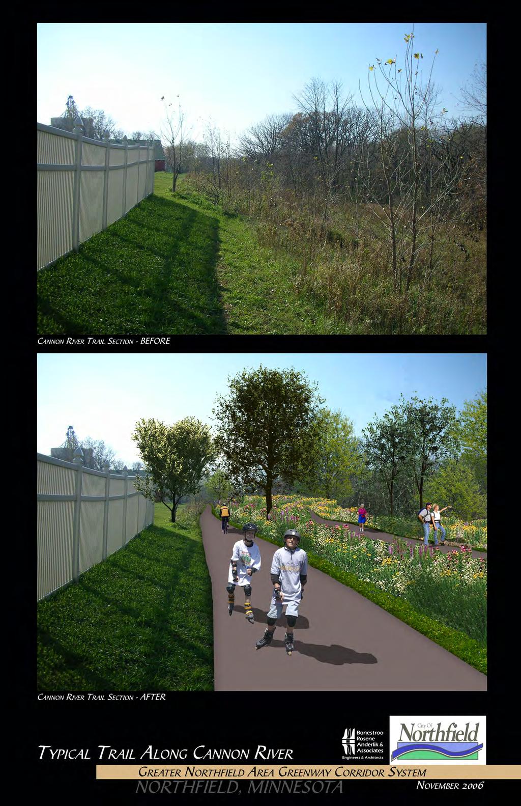
20 Cross Country Ski Trail Grants-in-aid Minnesota DNR Provides funding for maintenance of existing cross-country ski trails or development of new trails Federal SAFETEA-LU funds Provides funding for trail construction & maintenance, including 80% federal reimbursement for core programs under the Surface Transportation Program and Transportation Enhancement Program. Also includes some additional programs: o Safe Routes to School 100% federal share for projects that enable children to walk or bike to school o Federal Recreational Trails administered by DNR Provides funding for maintenance and development of motorized, non-motorized and diversified trails Open Space Grants Environmental and Conservation Partnerships Minnesota DNR Provides funding for enhancement of fish, wildlife and native plant habitats Park Grants Outdoor Recreation Grants Minnesota DNR Provides matching grants for up to 50% of the cost of acquisition, development and/or redevelopment of local parks and recreation areas Regional Park Grants Minnesota DNR Provides matching grants to public regional park organizations outside the seven county metropolitan area for up to 60% of the cost of acquisition, development and/or redevelopment costs of regional parks. 3.7 Priorities for Implementation The Task Force identified the following priority areas within the proposed Corridor System. These areas should be given priority for funding or other resources: East River Corridor (east side of the Cannon River from Highway #3 bridge south to Dundas). This area is a priority because it forms the backbone of the system, due to the potential for development, and because creation of this link will help to create strong support for the system. Members of the Task Force and attendees at the Open House agreed that the backbone of the system is the first priority for protection and trail development. A photo of the existing corridor area along the Cannon River and a simulation of a typical trail concept are shown on Figure 2. 16
21 Natural area protection, as well as access along Heath Creek and Spring Brook. The St. Olaf area loop on the west side of the system and west side of the St. Olaf campus. 17
22
23 Figure 2 18
24 Attachments 19
25 GREATER NORTHFIELD GREENWAY CORRIDOR SYSTEM OPEN HOUSE PARTICIPANT SURVEY November 1, total signed in; 19 surveys completed Your answers to these questions will help the Greenway Task Force and Parks Commission to plan for the Greenway System! 1. Please indicate the community you live in: 12 - Northfield City 1 - Greenvale Township 2 - Northfield Township 1 - Dundas 1 - Bridgewater Township 2. Do you think that a Greenway system including a connected system of natural areas, parks and trails like the concept plan is a good idea for the Northfield Area? 19 - Yes 0 - No 3. Should protection of natural areas with a connected system of open spaces be a priority for communities in the Northfield Area? 18 - It should be a priority 1 - It should not be a priority 4. Do you currently use trails for 17- recreation or 5 - commuting? Please check the types of trail uses: 17 - Walking/hiking 14 - Biking 3 - Skating/rollerblading 6 - Cross-country skiing 3 - Walking pet(s) 2 - Other: Running, working 4. Which of the loops on the map should be the highest priority for acquisition and protection? (check 1 or 2) 16 - Central trail spine along the Cannon River (6 indicated as 1 st priority) 6 - Other loops within the City of Northfield (2 indicated as 2 nd ; 1 as 3 rd ) 4 - Heath Creek Loop (2 indicated as 2 nd priority) 2 - Dundas Loop (1 indicated as 2 nd priority) 2 - Bridgewater Loop (1 indicated as 2 nd priority) 1 -Northfield Township Loop (indicated is shortest and potentially easiest loop to develop) 20
26 4 - Waterford Loop (1 indicated as 2 nd priority and 1 as 3 rd priority) 5. Please add other comments or information on the back of this page, to assist in planning for the Greenway System. Comments received: 1) Good job! Thanks for your work how can the community be involved in a helpful way? Individuals say they would bike to work if they had a better trail system. How could that be made more attractive to the high school students biking to school could they be part of the process at some point? The area at the end of Washington would make a great green space. That area has a wetland and a lot of wildlife that goes between the Sibley swale and the Rachel Carson Prairie area. 2) While the plan is a good start, the implementation will be the proof! The most important point, to me, is to incorporate bike/pathways in the already developed areas to the corridors. 3) It has long been a hope that every action taken by city council would have an environmental check-off box i.e. every action should be evaluated for its impact on the environment. For many actions it will not be relevant but where it is of concern, it could be very important. 4) Comments for plan, not in order of importance: An overall glance reveals one area that does not have equal access. That is the Southeast quadrant. There should be a corridor from the Northfield Township loop to downtown, near the soccer fields. It is hard for the general public to get oriented to the photo/map. Prominent features are not easily identified. Many existing trails are not even shown: o By the Target/Applebees o Riverside park o John North Park o Prairie Hills park and connecting private development o Trails around Northfield Retirement Center o Existing Mill Towns Trail 21
METROPOLITAN COUNCIL 390 North Robert Street, St. Paul, MN Phone (651) ; TDD (651)
 ; TDD (651)") DATE: December 20, 2011 METROPOLITAN COUNCIL 390 North Robert Street, St. Paul, MN 55101 Phone (651) 602-1000; TDD (651) 291-0904 TO: Metropolitan Parks and Open Space Commission FROM: Tori Dupre, Senior
DATE: December 20, 2011 METROPOLITAN COUNCIL 390 North Robert Street, St. Paul, MN 55101 Phone (651) 602-1000; TDD (651) 291-0904 TO: Metropolitan Parks and Open Space Commission FROM: Tori Dupre, Senior
Yadkin River Greenway Feasibility Study Fact Sheet Village of Clemmons, Town of Lewisville, Town of Bermuda Run
 Fact Sheet Village of Clemmons, Town of Lewisville, Town of Bermuda Run Project Background The Yadkin River Greenway Feasibility Study is a joint project with the Village of Clemmons, the Town of Bermuda
Town of Peru Comprehensive Plan Executive Summary
 Town of Peru Comprehensive Plan Executive Communities that plan grow by choice, not by chance. A plan makes growth thoughtful, understandable, and predictable. A plan shows that a community is managing
Parks, Trails, and Open space Element
 Parks, Trails, and Open space Element Parks, Trails, and Open Space element Parks, Recreation, and Open Space are important components of the quality of life desired by the residents of Elk Grove. This
Planning Districts INTRODUCTION
 INTRODUCTION To facilitate detailed examination of development prospects for all areas of the community, Delano has been divided into 14 planning districts. The location of these planning districts is
Mississippi Skyway Preliminary Engineering Report
 EXECUTIVE SUMMARY Mississippi Skyway Preliminary Engineering Report CITY OF RAMSEY, MINNESOTA DECEMBER 2014 City of RAMSEY EXECUTIVE SUMMARY Project Need and Intent The Mississippi Skyway pedestrian bridge
Provide and maintain sufficient public parks, recreation facilities, and open space to meet the recreational needs of County residents and visitors.
 (ROS) Goal Provide and maintain sufficient public parks, recreation facilities, and open space to meet the recreational needs of County residents and visitors. OBJECTIVE ROS.01 The County shall acquire,
City of Royalton Comprehensive Land Use Plan 2005 to Revision February 8, 2011
 City of Royalton Comprehensive Land Use Plan 2005 to 2015 2011 Revision February 8, 2011 PART ONE: INTRODUCTION TO THE COMPREHENSIVE PLAN 1.0 Purpose and Introduction The Comprehensive Land Use Plan provides
3. VISION AND GOALS. Vision Statement. Goals, Objectives and Policies
 Vision Statement Queen Creek s interconnected network of parks, trails, open spaces and recreation opportunities provide safe and diverse activities and programs that sustain its unique, small town, equestrian
Mendota Heights 2040 Comprehensive Plan Draft Vers
 4 Parks and Trails The City of Mendota Heights boasts a variety of recreational and open space opportunities. Few cities can claim access to regional trails, riverside and lakeside parks, scenic bluffs
Parks, Trails, and Open Space Element
 P arks, Recreation, and Open Space are important components of the quality of life desired by the residents of Elk Grove. This Element of the General Plan addresses the City s goals, policies, and actions
Whitemarsh Township Greenway Plan
 Whitemarsh Township Greenway Plan Prepared for: Whitemarsh Township August 16, 2007 Table of Contents Table of Contents... i Introduction... 1 Study Area Setting... 2 Regional Setting... 2 Township Character...
Regional Context Statement
 Regional Context Statement REGIONAL CONTEXT STATEMENT 3. REGIONAL CONTEXT STATEMENT In 1995, the Provincial Government passed into law the Growth Strategies Act. The purpose of this provincial initiative
This page intentionally blank.
 This page intentionally blank. Parks, Recreation, and Open Space Chapter Relationship to Vision Vision Parks, Recreation and Open Space Chapter Concepts County Government. County government that is accountable
The transportation system in a community is an
 7 TRANSPORTATION The transportation system in a community is an important factor contributing to the quality of life of the residents. Without a sound transportation system to bring both goods and patrons
The Five Components of the McLoughlin Area Plan
 The Five Components of the McLoughlin Area Plan This documents contains the complete language of the five components of the McLoughlin Area Plan: The Vision Statement The Values The Guiding Principles
CITY OF CHARLOTTESVILLE, VIRGINIA CITY COUNCIL AGENDA
 CITY OF CHARLOTTESVILLE, VIRGINIA CITY COUNCIL AGENDA Agenda Date: December 16, 2013 Action Required: Adoption of Resolution Presenter: Staff Contacts: Title: James E. Tolbert, AICP, Director of NDS James
Chapter 5: Natural Resources and Environment
 NATURAL RESOURCES AND ENVIRONMENT 5-1 5 Chapter 5: Natural Resources and Environment BACKGROUND AND INTENT Urban expansion represents the greatest risk for the future degradation of existing natural areas,
METROPOLITAN COUNCIL 390 North Robert Street, St. Paul, MN Phone (651) ; TDD (651)
 ; TDD (651)") DATE: October 24, 2012 METROPOLITAN COUNCIL 390 North Robert Street, St. Paul, MN 55101 Phone (651) 602-1000; TDD (651) 291-0904 TO: Metropolitan Parks and Open Space Commission FROM: Tori Dupre, Senior
DATE: October 24, 2012 METROPOLITAN COUNCIL 390 North Robert Street, St. Paul, MN 55101 Phone (651) 602-1000; TDD (651) 291-0904 TO: Metropolitan Parks and Open Space Commission FROM: Tori Dupre, Senior
G. RECREATION AND OPEN SPACE ELEMENT. The following summarizes the Recreation and Open Space Element:
 G. RECREATION AND OPEN SPACE ELEMENT The purpose of the Element is to provide the framework and direction for a comprehensive system of public and private sites for recreation, including, but not limited
1.0 INTRODUCTION 1.1 TH 14 WEST STUDY AREA Project Description Functional Classification Purpose of the Project
 1.0 INTRODUCTION 1.1 TH 14 WEST STUDY AREA 1.1.1 Project Description The Trunk Highway (TH) 14 West Corridor is a two-lane roadway approximately 22 miles in length. Located in Nicollet County, the corridor
A larger version of this map is located on the last page of this PDF.
 MAP Committee Input McLoughlin Area Draft Vision Map A larger version of this map is located on the last page of this PDF. 1. The map above is intended to portray a vision for the McLoughlin area. It highlights
Mendota-Lebanon Hills Greenway Master Plan Executive Summary. August draft for more information visit
 Mendota-Lebanon Hills Greenway Master Plan Executive Summary August 2013 draft for more information visit www.hkgi.com/projects/dakota INTRODUCTION The Mendota-Lebanon Hills Greenway Master Plan portrays
Chapter 14: Community Services and Public Utilities
 Chapter 14: Community Services and Public Utilities Goal: Cost-effective community services related to the needs of the community. Background The City of Dundas provides a variety of services to community
DISCUSSION TOPIC: ST JOHNS RIVER & ITS TRIBUTARIES (BPII) 2030 COMPREHENSIVE PLAN POLICES AND REGULATORY FRAMEWORK
 2030 COMPREHENSIVE PLAN POLICES AND REGULATORY FRAMEWORK") DISCUSSION TOPIC: ST JOHNS RIVER & ITS TRIBUTARIES (BPII) 2030 COMPREHENSIVE PLAN POLICES AND REGULATORY FRAMEWORK St. John s River & Its Tributaries Issue Summary: The St. Johns River is an important
DISCUSSION TOPIC: ST JOHNS RIVER & ITS TRIBUTARIES (BPII) 2030 COMPREHENSIVE PLAN POLICES AND REGULATORY FRAMEWORK St. John s River & Its Tributaries Issue Summary: The St. Johns River is an important
City of Missoula and Missoula County Open Space Planning Open House
 City of Missoula and Missoula County Open Space Planning Open House FEBRUARY 6, 2018 The following slides contain the display board content from the open house. Please use boards to answer questions in
Nine Mile Creek Regional Trail Update. Edina City Council Workshop March 4, 2014
 Nine Mile Creek Regional Trail Update Edina City Council Workshop March 4, 2014 Presentation Outline: Where we ve been - Recap of route assessment process and approved route Where we are now - Summary
PARTF Scoring System for Grants
 PARTF Scoring System for Grants The members of the N.C. Parks and Recreation Authority use the PARTF scoring system as one of several tools to select grant recipients. Please provide all of the information
Plan Overview. Manhattan Area 2035 Reflections and Progress. Chapter 1: Introduction. Background
 Plan Overview The Manhattan Urban Area Comprehensive Plan (the Comprehensive Plan) is a joint planning initiative of the City of Manhattan, Pottawatomie County, and Riley County. The 2014 Comprehensive
Gold Line Bus Rapid Transit Transit Oriented Development (BRTOD) Helmo Station Area Plan
 Helmo Station Area Plan") Appendix F Gold Line Bus Rapid Transit Transit Oriented Development (BRTOD) Helmo Station Area Plan Introduction and Purpose of the Plan The Gold Line Bus Rapid Transit facility is an eleven-mile dedicated
Appendix F Gold Line Bus Rapid Transit Transit Oriented Development (BRTOD) Helmo Station Area Plan Introduction and Purpose of the Plan The Gold Line Bus Rapid Transit facility is an eleven-mile dedicated
Rosemount Greenway Master Plan Executive Summary. draft. Spring for more information visit
 Rosemount Greenway Master Plan Executive Summary Spring 2012 draft for more information visit www.hkgi.com/projects/dakota INTRODUCTION The Rosemount Greenway Master Plan portrays a vision to establish
Riparian Buffer on the Bushkill Creek. Policies
 Riparian Buffer on the Bushkill Creek Riparian buffers provide numerous benefits to landowners and the community by protecting groundwater recharge areas, providing flood control, providing stormwater
CITY OF PUYALLUP. Background. Development Services
 CITY OF PUYALLUP Development Services 333 South Meridian Puyallup WA 98371 To: City Council From: Katie Baker, AICP, Planning Division Re: South Hill Neighborhood Plan Adoption Date: (Meeting date: February
RECREATION AND OPEN SPACE ELEMENT GOALS, OBJECTIVES, AND POLICIES
 RECREATION AND OPEN SPACE ELEMENT GOALS, OBJECTIVES, AND POLICIES Goal 7 To provide park facilities, recreation programs, and open space resources that are safe, adequate, and accessible to all City residents,
PROJECT BACKGROUND. Preliminary Design Scope and Tasks
 PROJECT BACKGROUND Preliminary Design Scope and Tasks The purpose of this Study is the development of preliminary designs for intersection improvements for Trunk Highway (TH) 36 at the intersections of
This chapter describes the purpose of the Plan, introduces how the Plan is organized and provides contextual background for the Plan.
 Chapter 1: INTRODUCTION Purpose of a Comprehensive Plan The 2040 Comprehensive Plan establishes Medina s vision as a community and sets goals and objectives which guide future decisions and policies. The
Minnesota Department of Natural Resource - Natural Resource Guidance Checklist Conserving Natural Resources through Density Bonuses
 Minnesota Department of Natural Resource - Natural Resource Guidance Checklist Conserving Natural Resources through Density Bonuses NRDB Why Use Density Bonuses & This Checklist Local units of government
SECTION II SECTION II STATEMENT OF GOALS, OBJECTIVES, PRINCIPLES, ASSUMPTIONS, POLICIES AND STANDARDS
 STATEMENT OF GOALS, OBJECTIVES, PRINCIPLES, ASSUMPTIONS, POLICIES AND STANDARDS 1 2 STATEMENT OF GOALS, OBJECTIVES, PRINCIPLES, ASSUMPTIONS, POLICIES AND STANDARDS INTRODUCTION The New Jersey Municipal
Description of Preferred Alternative
 Chapter 2 Description of Preferred Alternative 2.1 Introduction This chapter of the programmatic Sammamish Town Center Sub-area Plan Final EIS provides a more detailed description of the Preferred Alternative
1INTRODUCTION. Purpose of the Truckee Railyard Master Plan
 1INTRODUCTION Purpose of the Truckee Railyard Master Plan The purpose of the Truckee Railyard Master Plan is to capture and describe the Town s vision for the Railyard Area and to guide its future redevelopment.
PARKS AND RECREATION
 PARKS AND RECREATION WHAT YOU WILL FIND IN THIS CHAPTER: Background information on the development of the Park, Recreation, and System Plan (PRSP). General overview of Ellensburg s parks and recreation
Staff Report and Recommendation
 Community Planning and Development Planning Services 201 W. Colfax Ave., Dept. 205 Denver, CO 80202 p: 720.865.2915 f: 720.865.3052 www.denvergov.org/cpd TO: City Council Neighborhoods and Planning Committee
WATERFORD Plan of Preservation, Conservation and Development Supplement Part 1 - Policy Element
 WATERFORD 2012 Plan of Preservation, Conservation and Development 2015 Supplement Part 1 - Policy Element Effective June 11, 2015 2015 Plan Update GOAL To respond to the evolving land use needs and continually
Oakland County s Green Infrastructure Vision. L. Brooks Patterson Oakland County Executive
 Oakland County s Green Infrastructure Vision L. Brooks Patterson Oakland County Executive Southeast Michigan 20 miles northwest of Detroit Consists of 910 square miles Population of 1.2 million More than
NASSAU COUNTY TOWN HALL NEW YORK & CONNECTICUT SUSTAINABLE COMMUNITIES. A Unique Bi-State Partnership to Improve Jobs, Housing and Transportation
 NASSAU COUNTY TOWN HALL NEW YORK & CONNECTICUT SUSTAINABLE COMMUNITIES A Unique Bi-State Partnership to Improve Jobs, Housing and Transportation Police Headquarters Auditorium Mineola, NY December 9 th,
OFFICIAL CONTROLS IMPLEMENTATION LEGAL REQUIREMENTS
 IMPLEMENTATION The objective of the Implementation component of the Comprehensive Plan is to identify the changes that need to be made to the official controls in order to be consistent with the Comprehensive
Silverwood Masterplan Kickoff Meeting. Jim Neidhart Dane County Parks Planning
 Silverwood Masterplan Kickoff Meeting Jim Neidhart Dane County Parks Planning 608-224-3614 January 30, 2014 Silverwood County Park Public Information Meeting Notice Sent notice to all landowners adjacent
Office of Greenways & Trails Providing Statewide Leadership and Coordination. Southeast Greenways and Trails Summit October 1-3, 2017
 Office of Greenways & Trails Providing Statewide Leadership and Coordination Southeast Greenways and Trails Summit October 1-3, 2017 1 Office of Greenways and Trails The Office of Greenways and Trails
2018 Northampton Township Comprehensive Plan
 2018 BUCKS COUNTY, PENNSYLVANIA What is a? A comprehensive plan is a municipality s main policy document that details the collective vision for the future, the historic, environmental, and cultural facilities
TOWN OF BETHLEHEM OPEN SPACE CONSERVATION PLAN PUBLIC MEETING: OCTOBER 12, 2017
 TOWN OF BETHLEHEM OPEN SPACE CONSERVATION PLAN PUBLIC MEETING: OCTOBER 12, 2017 Welcome and Agenda 6:00 6:45: Open House, Part One 6:45 7:15: Presentation and Questions 7:15 8:00: Open House, Part Two
RECREATION, OPEN SPACE AND GREENWAYS ELEMENT GOALS, OBJECTIVES, AND POLICIES
 RECREATION, OPEN SPACE AND GREENWAYS ELEMENT GOALS, OBJECTIVES, AND POLICIES GOAL R-1: DEVELOP A RECREATION, OPEN SPACE AND GREENWAYS SYSTEM AS AN INTEGRAL COMPONENT OF AN OVERALL, COUNTY-WIDE ECONOMIC
The City shall enhance and improve the accessibility of parks and recreational facilities while protecting their quality. by:
 GOALS, OBJECTIVES AND POLICIES GOAL 1: To provide open space and recreation as an essential element needed for the betterment of the City s character and quality of urban life. The City shall plan for
Welcome. Comprehensive Plan & Transportation Plan Open House November 7, 2012
 Welcome Comprehensive Plan & Transportation Plan Open House November 7, 2012 Agenda Proposed future land use plan Comprehensive Plan strategies Traffic forecasts Future traffic operations Possible future
Draft Stillwater 2030 Comprehensive Plan- Goals and Policies
 Draft Stillwater 2030 Comprehensive Plan- Goals and Policies Instructions- Review each goal and policy and discuss with group any changes, deletions for additions to the list using your groups pen. Keep
LEMON CREEK AREA PLAN. Steering Committee Meeting April 27, 2017
 LEMON CREEK AREA PLAN Steering Committee Meeting April 27, 2017 Agenda Roll Call (6:00pm) Approval of Minutes April 20, 2017 (5 minutes) Review and Approve the Natural Resources & Recreation Chapter, Goals,
DRAFT MAP AMENDMENT FLU 04-4
 DRAFT MAP AMENDMENT FLU 04-4 SW 24 TH AVENUE ROADWAY CORRIDOR The University of Florida participates with the Metropolitan Transportation Planning Organization (MTPO) in its responsibilities for the continuing,
Arlington, Virginia is a worldclass
 EXECUTIVE S U M M A RY Arlington maintains a rich variety of stable neighborhoods, quality schools and enlightened land use policies, and received the Environmental Protection Agency s highest award for
Photo by Carlton Ward Jr. Executive Summary
 Photo by Carlton Ward Jr. Executive Summary The Cooperative Conservation Blueprint (Blueprint) is a multi-partner strategic conservation process developed by the Florida Fish and Wildlife Commission (FWC)
Chapter 10 IMPLEMENTATION RECOMMENDATIONS
 Chapter 10 IMPLEMENTATION RECOMMENDATIONS The recommended land use plan presented in the previous chapter provides a design for the attainment of the urban and rural development and open space preservation
ADOPTION OF THE REVISED OPEN SPACE AND CONSERVATION ELEMENT OF THE GENERAL PLAN
 TO: FROM: SUBJECT: Honorable Mayor and City Council Planning Department ADOPTION OF THE REVISED OPEN SPACE AND CONSERVATION ELEMENT OF THE GENERAL PLAN RECOMMENDATION: It is recommended that the City Council:
DRAFT PLAN PRESENTATION
 DRAFT PLAN PRESENTATION 1.23.2018 AGENDA Process Project Schedule Results from Visioning Workshop Draft Plan Highlights Concept Plans Feedback Next Steps PROJECT SCHEDULE KICK-OFF WORKSHOP August 29 th
It Takes A Village.. Preserving Rural Character In Standish
 It Takes A Village.. Preserving Rural Character In Standish A Public Workshop Hosted by Conservation and Open Space Plan Committee & Standish Corner Village Implementation Committee June 12, 2008 Desired
CITY OF VAUGHAN EXTRACT FROM COUNCIL MEETING MINUTES OF NOVEMBER 15, 2016
 Item 11, Report No. 38, of the Committee of the Whole, which was adopted without amendment by the Council of the City of Vaughan on November 15, 2016. Regional Councillor Di Biase declared an interest
The following principles guide the development of goals and strategies to protect and promote these amenities:
 OPEN SPACE/PARKS/TRAILS/RECREATION GOALS/STRATEGIES Cherry Hills Village is a living environment that offers low density development, open areas, public scenic vistas, public trails and public parks. This
Chapter 13: Implementation Plan
 Implementation A. Introduction The Implementation Plan, in table form on the following pages, provides a summary of all the Action Items recommended in Chapters 2 through 12. The table also indicates which
RESOLUTION NO. R Refining the route, profile and stations for the Downtown Redmond Link Extension
 RESOLUTION NO. R2018-32 Refining the route, profile and stations for the Downtown Redmond Link Extension MEETING: DATE: TYPE OF ACTION: STAFF CONTACT: Capital Committee Board PROPOSED ACTION 09/13/2018
GENERAL LAND USE PLAN ELEMENT
 CITY OF Prepared by City of Medford Planning Department 200 South Ivy Street Medford, Oregon 97501 plnmed@ci.medford.or.us James E. Huber, AICP, Planning Director COMPREHENSIVE PLANNING SECTION John Adam,
Support for Walnut Creek Watershed Council. Adopt resolution of support for the newly formed Walnut Creek Watershed Council.
 CITY OF MARTINEZ CITY COUNCIL AGENDA March 6, 2013 TO: FROM: SUBJECT: DATE: Mayor and City Council Tim Tucker, City Engineer Support for Walnut Creek Watershed Council March 1, 2013 RECOMMENDATION: Adopt
DRAFT Amsterdam/Churchill Community Plan (4/17/08) Adopted By the Gallatin County Commission
 Adopted By the Gallatin County Commission") DRAFT Amsterdam/Churchill Community Plan (4/17/08) Adopted By the Gallatin County Commission Table of Contents Acknowledgements Chapter 1: Introduction A Brief History What s Next Authority Organization
DRAFT Amsterdam/Churchill Community Plan (4/17/08) Adopted By the Gallatin County Commission Table of Contents Acknowledgements Chapter 1: Introduction A Brief History What s Next Authority Organization
Executive Summary. NY 7 / NY 2 Corridor
 Executive Summary NY 7 / NY 2 Corridor Transportation and Land Use Study December 2005 Prepared for: Town of Colonie Capital District Transportation Committee Prepared by: Introduction: Land use decisions
2030 Comprehensive Plan VISION STATEMENT
 RESOURCE DOCUMENT for Steering Committee Meeting #2 July 12, 2017 2030 Comprehensive Plan VISION STATEMENT Steering Committee from 2008 Established the Lauderdale s Vision as: Creating a livable, lovable
Parks and Open Space Preservation and Dedication. January 26, 2016 Fort Worth City Council Pre-Council Meeting Randle Harwood and Richard Zavala
 Parks and Open Space Preservation and Dedication January 26, 2016 Fort Worth City Council Pre-Council Meeting Randle Harwood and Richard Zavala Purpose How does the City of Fort Worth preserve and protect
Transportation Committee
 Transportation Committee Business Item No. 2013-286SW Meeting date: October 14, 2013 For the Metropolitan Council meeting of October 16, 2013 Subject: Southwest Light Rail Transit (Green Line Extension):
Asbury Chapel Subdivision Sketch Plan
 Asbury Chapel Subdivision Sketch Plan PART 1: PROJECT SUMMARY Applicant: NVR Inc. Project Size: +/- 76.13 acres Parcel Numbers: 02101112,02116101,02116112, 02116113 Current Zoning: Transitional Residential
LAND USE ELEMENT. Purpose. General Goals & Policies
 LAND USE ELEMENT Purpose This Land Use Element contains the goals and policies necessary to support the City s responsibility for managing land resources and guiding development through implementing regulations,
Green Infrastructure The Indianapolis Greenways Connection
 Green Infrastructure The Indianapolis Greenways Connection Fewer things in the transportation industry today make better since than combining the needs for pedestrian and bike trails with the need to locate,
TIRZ 17/Redevelopment Authority Capital Improvements Plan Projects
 Gessner Widening: T-1701 What: Widen the road from a six-lane divided boulevard to an eight-lane divided boulevard street section, increase turn lanes, update traffic signal system, improve drainage by
The West Vaughan Employment Area Secondary Plan Policies
 Part 2: The West Vaughan Employment Area Secondary Plan Policies 2.1 General Policies It is the policy of Council: 2.1.1. That the West Vaughan Employment Area (the WVEA), identified on Schedule 1, will
6.0 Conclusions & Recommendations
 6.0 Conclusions & Recommendations 75 The research, public outreach and feasibility analysis completed for this study indicate that Trail Alternative #2 (South side of Doctors Creek) is the most comprehensive
Noblesville Alternative Transportation Plan 2015
 Noblesville Alternative Transportation Plan 2015 Noblesville Alternative Transportation Plan 2015 This report document was prepared under Contract for the Noblesville Department of Parks and Recreation
I. STAFF POLICY RECOMMENDATIONS. The following RMP policy strategies are proposed by staff in support of a Scenic Resource Protection Program:
 Policy Consideration: Scenic Resource Protection Program Status: For Consideration by the Highlands Council at September 14, 2006 Work session Date: September 12, 2006 I. STAFF POLICY RECOMMENDATIONS The
The Illinois Department of Transportation and Lake County Division of Transportation. Route 173, including the Millburn Bypass
 The Illinois Department of Transportation and Lake County Division of Transportation welcome you to this Public Hearing for U.S. Route 45 from Illinois Route 132 to Illinois Route 173, including the Millburn
CONCLUSION AND IMPLEMENTATION
 Lisbon s Vision CONCLUSION AND IMPLEMENTATION 7 Lisbon residents clearly appreciate the character, amenities, and opportunities that define our community. This Plan of Conservation and Development identifies
NORTHEAST RIVER CROSSING FUNCTIONAL PLANNING STUDY
 WELCOME Northeast River Crossing Functional Planning Study Phase 2 Public Meeting 4 to 8 PM Informal drop-in format and discussion tables Meeting Purpose Introduce the Northeast River Crossing Functional
A BLUEPRINT FOR BROCKTON A CITY-WIDE COMPREHENSIVE PLAN
 A BLUEPRINT FOR BROCKTON A CITY-WIDE COMPREHENSIVE PLAN Public Meeting October 2016 1 Plan Summary and Discussion Public Meeting May 4 2017 City of Brockton Bill Carpenter, Mayor Department of Planning
Comprehensive Plan. Faribault, Minnesota. Hoisington Koegler Group Inc. Claybaugh Preservation Architecture Inc. Howard R. Green Company Bonz/REA
 Comprehensive Plan Faribault, Minnesota Adopted by the Faribault City Council July 8, 2003 prepared for: prepared by: Hoisington Koegler Group Inc. Claybaugh Preservation Architecture Inc. Howard R. Green
PART 1: PROJECT SUMMARY. The application is Attachment A. The site plan is Attachment B.
 Belleterre Subdivision Sketch Plan Town Board 8.7.17 Belleterre Subdivision Sketch Plan PART 1: PROJECT SUMMARY Applicant: Bowman Development Project Size: +/- 20.85 acres Parcel Number: 01115104 and 01115121
TOWN OF BETHLEHEM MEETING SUMMARY LOCAL WATERFRONT REVITALIZATION PROGRAM UPDATE
 TOWN OF BETHLEHEM LOCAL WATERFRONT REVITALIZATION PROGRAM UPDATE MEETING SUMMARY Purpose: LWRP Update Public Workshop #3 Date and Time: October 24, 2017, 6:00 pm - 8:00 pm Location: Town Hall, 445 Delaware
4-Town Comprehensive Plan DRAFT 7/30/07
 4-Town Comprehensive Plan DRAFT 7/30/07 Acknowledgements ning Committee Town of Harrisburg Norman Roof Randy Nicol Town of Martinsburg Terry Thisse Paul Kelly Town of Montague Jan Bagdanowicz Wendy Perry
Section 4 BUILDING THE MASTER PLAN
 The Master Plan 33 Section 4 BUILDING THE MASTER PLAN Figure 4:1. A collaborative effort characterized the two design workshops sponsored by DISC to create hypothetical Master Plans for the Towers Property
FOSTER COMPREHENSIVE PLAN UPDATE CIRCULATION
 5.8.1 INTRODUCTION CIRCULATION The Circulation Element of the Comprehensive Plan studies the routes and modes of travel. The circulation network of the town affects the ease of movement through Foster
CHAPTER 4 FUTURE LAND USE AND URBAN SERVICES DISTRICTS
 CHAPTER 4 FUTURE LAND USE AND URBAN SERVICES DISTRICTS Introduction This chapter discusses how Benzie County should grow and change in the future. A community can grow and change in many different ways.
Date: April 10, 2017 City Council Work Session April 24, 2017: Status Report on the Comprehensive Plan Update and Transportation Master Plan
 AGENDA REPORT To: From: By: Honorable Mayor and City Council Members Warren Hutmacher, City Manager Sharon Ebert, Director Community Development Date: April 10, 2017 Agenda: City Council Work Session April
AWH REPORT OF THE PLANNING AND DEVELOPMENT DEPARTMENT FOR APPLICATION FOR REZONING ORDINANCE TO PLANNED UNIT DEVELOPMENT
 AWH REPORT OF THE PLANNING AND DEVELOPMENT DEPARTMENT FOR APPLICATION FOR REZONING ORDINANCE TO PLANNED UNIT DEVELOPMENT MAY 8, 2014 The Planning and Development Department hereby forwards to the Planning
Overview of Southwestern Pennsylvania Commission s (SPC) 2040 Long Range Transportation Plan (LRTP)
 2040 Long Range Transportation Plan (LRTP)") Overview of Southwestern Pennsylvania Commission s (SPC) 2040 Long Range Transportation Plan (LRTP) Presented to Pennsylvania Agency Coordination Meeting May 27, 2015 Doug Smith & Ryan Gordon 1 Southwestern
Overview of Southwestern Pennsylvania Commission s (SPC) 2040 Long Range Transportation Plan (LRTP) Presented to Pennsylvania Agency Coordination Meeting May 27, 2015 Doug Smith & Ryan Gordon 1 Southwestern
Transportation. Strategies for Action
 Transportation A major priority for the Overlake Neighborhood is to develop a multimodal transportation system. To achieve this system, a balance has to be found among travel, circulation and access needs;
Implementation Guide Comprehensive Plan City of Allen
 Implementation Guide 2030 Comprehensive Plan City of Allen DRAFT 2015 Implementation Guide Allen 2030 Comprehensive Plan INTRODUCTION The Comprehensive Plan serves as a guide for the growth and development
PRELIMINARY REPORT. HIGHWAY 18 CORRIDOR NEIGHBORHOOD PLAN VILLAGE OF DOUSMAN November, 2014
 PRELIMINARY REPORT HIGHWAY 18 CORRIDOR NEIGHBORHOOD PLAN VILLAGE OF DOUSMAN November, 2014 This preliminary report presents the initial recommendations for land use within the Highway 18 corridor along
COMPREHENSIVE PLAN & UNIFIED DEVELOPMENT ORDINANCE
 Village of Forsyth COMPREHENSIVE PLAN & UNIFIED DEVELOPMENT ORDINANCE Community Planning #6 Prepared by: Vision Statement We envision the Forsyth Community as one which will continue to maintain a small
RESPONSES TO PUBLIC CONCERNS AND QUESTIONS
 RESPONSES TO PUBLIC CONCERNS AND QUESTIONS Stations and Summary Questions for Public Meeting #2 June 23, 2015 General Questions / Concerns: 1. Is there any way this development can raise revenue for the