Clearview North. Neighborhood Area Structure Plan. Reference# Ross Stre I Red Deer AB T4N 1X5. March 2009
|
|
|
- Claud Norris
- 5 years ago
- Views:
Transcription

1 Clearview North Neighborhood Area Structure Plan Reference# SLlr I _ Cv... ulhr.g l..v Ross Stre I Red Deer AB T4N 1X5 March 2009 Amended on March 23, 2009 Bylaw 3217/B-2009
2 Clearview North Neighbourhood Area Structure Plan February 2009 Prepared by: Stantec Consulting Ltd Ross Street Red Deer, AB T4N 1X5 Tel (403) Fax (403)
3 Clearview North Neighbourhood Area Structure Plan Table of Contents 1.0 INTRODUCTION PURPOSE PLAN AREA POLICIES AND RELEVANT PLANNING DOCUMENTS SITE CONTEXT AND DEVELOPMENT CONSIDERATIONS TOPOGRAPHY AND VEGETATION NATURAL FEATURES HISTORICAL LAND USE ADJACENT LANDS AND SURROUNDING DEVELOPMENT EXISTING UTILITIES NAL PIPELINES METER RIVER BANK ESCARPMENT SETBACK GAETZ LAKES DEVELOPMENT INFLUENCES DEVELOPMENT OBJECTIVES AND PRINCIPLES DEVELOPMENT OBJECTIVES DEVELOPMENT PRINCIPLES Residential Commercial Municipal Reserves and Educational / Community Facilities Transportation Ecological Stewardship DEVELOPMENT CONCEPT NEIGHBOURHOOD UNIT RESIDENTIAL Low Density Residential Smaller Lot Residential (R1N) Semi-detached Residential (R1A) Medium Density Residential (R2 / R3) Two-Storey Walkout Lots PLACE OF WORSHIP AND DAY CARE SITE PARKS AND OPEN SPACES Central Park Site Local Park Sites Walkways and Multi-Use Trail Homestead Site Existing Wetlands gcl w:\active\ mcfarland lands planning\nasp report\feb 2009 amendments\clearview north nasp amendments.doc i
4 Introduction February, River Valley Escarpment Setback Area Gathering Places Topsoil Stockpile EDUCATIONAL AND COMMUNITY FACILITIES COMMERCIAL (TOWN CENTRE) STORMWATER MANAGEMENT FACILITIES TRANSPORTATION Arterial Roadways Collector Roadways Local Roads Laneways EMERGENCY SERVICES ARTERIAL BERMS / NOISE MUNICIPAL SERVICING STORMWATER MANAGEMENT SANITARY SEWER SERVICING WATER DISTRIBUTION SHALLOW UTILITIES IMPLEMENTATION DEVELOPMENT STAGING REDISTRICTING AND SUBDIVISION PLAN AMENDMENTS gcl w:\active\ mcfarland lands planning\nasp report\feb 2009 amendments\clearview north nasp amendments.doc ii
5 Introduction February, 2009 List of Figures Figure 1 Figure 2 Figure 3 Figure 4 Figure 5 Figure 6 Figure 7 Figure 8 Figure 9 Figure 10 Figure 11 Figure 12 Figure 13 Figure 14 Figure 15 Figure 16 Figure 17 Figure 18 Location Plan Legal Boundary by Owner Land Areas Plan Existing Conditions Plan Project Area Development Concept Development Concept with Aerial Photo School/Park Site Concept Escarpment Setback Cross Sections Wetland Pond Concept Overall Collector Roadway Pattern Road Cross Sections Road/Paved Trail Cross Sections Major Stormwater Concept Plan Proposed Stormwater Management Plan Sanitary Sewer Plan Water Distribution Plan Phasing Plan gcl w:\active\ mcfarland lands planning\nasp report\feb 2009 amendments\clearview north nasp amendments.doc iii
6 1.0 Introduction 1.1 PURPOSE The purpose of this Neighbourhood Area Structure Plan (NASP) is to describe the land use framework and development objectives for four parcels of land collectively called Clearview North. The Clearview North NASP includes the following parcels of land: a. First, the remainder of the NE quarter section located directly south of 67 Street and west of 30 Avenue. This parcel of land has an area of approximately hectares ( acres). b. Second, Lot 2, Block 1, Plan in the NW located east of the existing Gaetz Lake Sanctuary and directly south of 67 Street. This parcel of land has an area of 16.7 hectares (41.27 acres). c. Thirdly, parts of Lots 1 & 2, Plan and a portion of Road Plan , having an area of approximately 4.30 hectares (10.63 acres) will be available for consolidation with the remainder of NE quarter section W4 once the realignment of the 67 Street and 30 Avenue intersection is complete. d. Finally, a small parcel in the northeast corner of SE W4M (0.57 hectares). These parcels were first considered in the East Hill Major Area Structure Plan (NASP) as one of a number of neighbourhood units accommodating future residential growth in east Red Deer. This report has been prepared by Stantec Consulting Ltd. on behalf of Melcor Developments Ltd. Melcor s intent through the Clearview North NASP is to develop a balanced community of residential and recreational opportunities with complimentary land uses. In order to achieve this, Melcor intends to integrate the area with interconnected parks and open space linkages, in addition to the development of high-quality residential opportunities that complement the existing landscape and Gaetz Lake Sanctuary. Together, these aspects will provide The City of Red Deer with a unique area for community development. This document will describe the land use pattern and the development objectives for the Clearview North NASP. The NASP will implement the land use framework and development objectives by identifying the following: size and location for various land uses; alignment of roadways and lanes; gcl w:\active\ mcfarland lands planning\nasp report\feb 2009 amendments\clearview north nasp amendments.doc 1.1
7 Introduction February, 2008 open park system; proposed development density; servicing concepts for deep utility servicing; and development staging sequence. The detailed design of each phase (re-districtings and plans of subdivision) will refine the concept presented by the NASP Bylaw for the Clearview North NASP. 1.2 PLAN AREA Figure 1.0 shows that the subject lands are located in the northeast and a portion of the northwest quarter of Section W4M in the northeast corner of The City of Red Deer, directly bordered by both 67 Street and 30 Avenue to the north and east respectively. The NASP is defined by the following boundaries: East Boundary North Boundary West Boundary South Boundary 30 Avenue, 67 Street, East property line of the Gaetz Lakes Sanctuary, SE quarter section W4, known as the Michener Lands. The property is legally described as the NE quarter section W4M, a portion of the NW quarter section W4M and a portion of the SE quarter section W4M. Figure 2.0 Legal Boundaries, illustrates the boundary of this development. The existing land parcels contained within this boundary are currently owned by Melcor Developments, the Province of Alberta, or The City of Red Deer as also identified on Figure 2.0. The Clearview North NASP constitutes a logical planning unit with respect to identifiable plan boundaries and servicing considerations and is consistent with the area identified in the East Hill Major Area Structure Plan. 1.3 POLICIES AND RELEVANT PLANNING DOCUMENTS The following relevant documents have been reviewed and referenced in preparation of this outline plan report: East Hill Major Area Structure Plan Municipal Development Plan gcl w:\active\ mcfarland lands planning\nasp report\feb 2009 amendments\clearview north nasp amendments.doc 1.2
8 Introduction February, 2008 Neighbourhood Planning Guidelines 2006 Edition Geotechnical Investigation on the Clearview North Property Phase 1 Environmental Assessment on the Clearview North Property Ecological Profile of Michener Centre Natural Area Michener Centre Development and Subdivision Guidelines As shown on Figure 3.0, there will be 4.03 ha, currently owned by The City of Red Deer, incorporated into this Plan once the 30 Avenue and 67 Street intersection is re-configured. The Clearview North Neighbourhood Area Structure Plan has been prepared as a statutory plan. It adheres to Section 633 of the Municipal Government Act of Alberta and follows the guidelines and policies set forth by The City of Red Deer for the development of new areas. These policies and guidelines are outlined in the Municipal Development Plan, East Hill Major Area Structure Plan and The City of Red Deer Neighbourhood Planning Standards and Guidelines. The East Hill Major Area Structure Plan provides a framework for orderly and economic growth of The City s east residential neighbourhoods in order to create safe and healthy living environments. It was created in 1977 and has been amended on several occasions since this time, most recently in This Plan sets out the broader transportation and land use objectives for multiple quarter sections in East Red Deer, which includes locations of collector roads, locations of arterial roads, identifying school and recreational sites, identifying trail systems, and allocating commercial and residential land uses. This includes a mixed use Town Centre site identified for this plan area. The Municipal Development Plan outlines broad policies for guiding growth and changes in The City of Red Deer for the next 25 years and has been updated recently. Among many other things the MDP sets out the following policies regarding neighbourhood designs: The Neighbourhood Planning Guidelines and Standards to guide the creation of sustainable neighbourhoods. The residential density in new neighbourhoods shall be between the range of to dwelling units per net developable hectares. (The net developable area measured in hectares, is the gross plan area less land for environmental reserve; major roads (expressways and arterials); commercial sites; industrial uses; high schools and sport fields additional to municipal reserve land dedicated for these purposes; and, as determined by The City, special land use sites, constructed wetlands and retention (wet) ponds, or portions thereof, that have high aesthetic values.) gcl w:\active\ mcfarland lands planning\nasp report\feb 2009 amendments\clearview north nasp amendments.doc 1.3
9 Introduction February, 2008 The City shall continue to require a mix of housing types and forms in all residential neighbourhoods. The City shall encourage the creation of a wide variety of housing forms. In August of 1996, Parkland Community Planning Services prepared a set of guidelines to identify issues and conditions under which any Outline Plan would be prepared for lands adjacent to the Gaetz Lakes Sanctuary. The purpose of this document was to preserve and enhance unique environmental features on the Michener Lands. Area 1, as defined in the guidelines, is included in the Clearview North NASP. This is the triangular parcel of land south of 67 Street and on the east boundary of the Gaetz Lakes Sanctuary. The guidelines note that the following factors should be addressed: (a) (b) (c) (d) Slope Stability The developer shall be required to do a hydro geotechnical evaluation to assess the slope stability; information regarding both groundwater movement and the effect of lawn sprinkling is necessary to determine its effect upon slope stability and sanctuary water levels. A preliminary setback of 100 metres from the slope is required; the width of the setback may be varied on the basis of the geotechnical evaluation but in no circumstances shall the setback be less than 50 metres. Protection of Gaetz Lakes The developer shall be required to design the subdivision to ensure that the Gaetz Lakes are protected from any negative impacts (for example, no trails or walkways which would directly access the escarpment). Fencing of the sanctuary site is to be undertaken; the design and cost will be negotiated between The City and the respective developer. Wildlife Corridor The developer shall be required to preserve the existing wildlife corridor along the top of the slope. This could be accommodated with a minimum 50 metre setback. Land Use In addition to existing agricultural use, the only land uses permitted on this site are institutional uses related to the delivery of Michener Centre services or residential uses. gcl w:\active\ mcfarland lands planning\nasp report\feb 2009 amendments\clearview north nasp amendments.doc 1.4
10 2.0 Site Context and Development Considerations 2.1 TOPOGRAPHY AND VEGETATION As shown on Figure 4.0 Existing Conditions, the site topography is relatively flat with the ground surface elevation ranging from 883 metres to 886 metres. The highest ground contour is located in the southwest and southeast portion of the Plan area, tapering off to the lowest area which is the existing seasonal drainage course located in the extreme north east corner of the Plan. The local vegetation consists of trees and bushes around the south and east sides of the site as shown in the aerial photograph on Figure 4.0. The remainder of the quarter section has remained as vacant agricultural land and overlooks the Gaetz Lakes reserve to the west of the property. Based on the geotechnical report prepared by Parkland GEO, in July of 2006, the soils on this site consist of topsoil and lacustrine soils overlying a sandy clay till. No bedrock was encountered. 2.2 NATURAL FEATURES The City of Red Deer s Recreation, Parks and Culture Department s Ecological Profile of the Michener Center Natural Area, prepared in 1998, identified a number of natural features systems in the Michener land area. This includes the existing drainage channel located at the northeast corner of the site, directly opposite the 67 Street / 30 Avenue roadway transition. This drainage course is primarily a seasonal drainage route to accommodate spring runoff from several quarter sections east of 30 Avenue. Drainage from this area is directed through a culvert across 67 Street and from here into the Mackenzie Lakes area. This drainage channel fluctuates between wet and dry cycles depending on precipitation levels. Willow species and long grasses grow in the lower-lying areas. The Profile identifies two zones of trees; one at the south end of the drainage channel and the second on a suspected abandoned homestead site. Both stands are to some extent protected by cultivated agricultural land and a 3 meter high fence in the case of the latter. The stands consist mainly of poplar and white spruce, with mosses, lichen, and fungi as ground cover. The homestead stand is surrounded with a hedge of caragana and dogwood. The far west portion of the site adjacent to the Gaetz Lakes Sanctuary is identified as upper escarpment. The growth includes mixed poplars and spruce, with Manitoba Maple and Mountain Ash as undergrowth. This area contains a high diversity of vegetative material. gcl w:\active\ mcfarland lands planning\nasp report\feb 2009 amendments\clearview north nasp amendments.doc 2.1
11 2.0 Site Context and Development Considerations 2.1 TOPOGRAPHY AND VEGETATION As shown on Figure 4.0 Existing Conditions, the site topography is relatively flat with the ground surface elevation ranging from 883 metres to 886 metres. The highest ground contour is located in the southwest and southeast portion of the Plan area, tapering off to the lowest area which is the existing seasonal drainage course located in the extreme north east corner of the Plan. The local vegetation consists of trees and bushes around the south and east sides of the site as shown in the aerial photograph on Figure 4.0. The remainder of the quarter section has remained as vacant agricultural land and overlooks the Gaetz Lakes reserve to the west of the property. Based on the geotechnical report prepared by Parkland GEO, in July of 2006, the soils on this site consist of topsoil and lacustrine soils overlying a sandy clay till. No bedrock was encountered. 2.2 NATURAL FEATURES The City of Red Deer s Recreation, Parks and Culture Department s Ecological Profile of the Michener Center Natural Area, prepared in 1998, identified a number of natural features systems in the Michener land area. This includes the existing drainage channel located at the northeast corner of the site, directly opposite the 67 Street / 30 Avenue roadway transition. This drainage course is primarily a seasonal drainage route to accommodate spring runoff from several quarter sections east of 30 Avenue. Drainage from this area is directed through a culvert across 67 Street and from here into the Mackenzie Lakes area. This drainage channel fluctuates between wet and dry cycles depending on precipitation levels. Willow species and long grasses grow in the lower-lying areas. The Profile identifies two zones of trees; one at the south end of the drainage channel and the second on a suspected abandoned homestead site. Both stands are to some extent protected by cultivated agricultural land and a 3 meter high fence in the case of the latter. The stands consist mainly of poplar and white spruce, with mosses, lichen, and fungi as ground cover. The homestead stand is surrounded with a hedge of caragana and dogwood. The far west portion of the site adjacent to the Gaetz Lakes Sanctuary is identified as upper escarpment. The growth includes mixed poplars and spruce, with Manitoba Maple and Mountain Ash as undergrowth. This area contains a high diversity of vegetative material. gcl w:\active\ mcfarland lands planning\nasp report\nov 2008 amendments\clearview north nasp amendments.doc 2.1

12 Site Context and Development Considerations February, HISTORICAL LAND USE The subject area is agricultural land and there once was a homestead located at the southwest corner of the site. Access to this property is accommodated by an existing gravel road that runs north-south from 67 Street to the south limit of the site dividing the two parcels of land that comprise Clearview North. Another gravel road runs west, perpendicular to the west limit of the site. 2.4 ADJACENT LANDS AND SURROUNDING DEVELOPMENT As shown in Figure 1.0, adjacent property to the south is the Michener Center. The Michener Center is still active but it is anticipated that this property, currently owned by the Province of Alberta, will eventually be re-developed as urban residential development once this facility is no longer required by the Province. The Gaetz Lakes Sanctuary, considered an Environmental Reserve, and the Red Deer River, are located to the west and will provide a striking setting for the Clearview North development. 30 Avenue to the east and 67 Street, both four-lane divided arterial highways to the north, separate the Clearview North property from adjacent farmland. A farming residence is located on adjacent land to the north. This property is also contemplated for residential development in the future. Vacant agricultural land is located east of Clearview North across 30 Avenue. Proposed future development for this area includes mixed used commercial and residential developments. The City of Red Deer is currently preparing an independent NASP for this property, titled The Timberlands NASP. 2.5 EXISTING UTILITIES No existing utilities are located in Clearview North. 2.6 NAL PIPELINES NAL Resources maintain several existing oil and gas wells and pipelines to the north and east of this proposed plan. Some of these facilities contain sour gas. Alberta Energy and Utilities Board (AEUB) requires facilities containing sour gas to establish emergency response plans to assist in managing the risk to public safety associated with a potential release of sour gas to the environment. These plans are developed to assist in contacting and potentially evacuating residents living within pre-determined Emergency Planning Zones (EPZ). An EPZ is an area surrounding a facility, pipeline, or well where residents or other members of the public may be at gcl w:\active\ mcfarland lands planning\nasp report\feb 2009 amendments\clearview north nasp amendments.doc 2.2
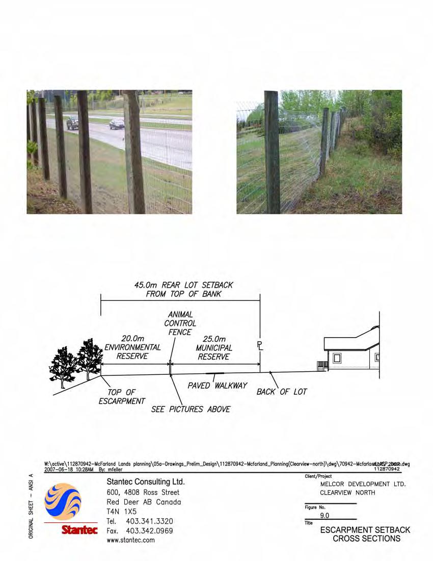
13 Site Context and Development Considerations February, 2008 risk during an uncontrolled sour gas release, explosion or fire and the area for which the operator of the facility must have a specific emergency response plan. The size of the EPZ surrounding sour gas facilities is established based on the magnitude of the maximum anticipated potential volume or rate of sour gas release in the event of an uncontrolled release. The oil and gas operator is responsible for providing information and education to the public within the EPZ regarding the correct procedures in case of an uncontrolled release. During an emergency, the oil and gas operator and the Emergency Services Department will coordinate the emergency response. The EPZ boundary for the NAL sour gas facilities north and east of this plan area does not currently fall within the boundary of the Clearview North plan area, however future regulation changes within AEUB and/or The City of Red Deer may change the emergency planning zone boundary METER RIVER BANK ESCARPMENT SETBACK In October of 1997, The City of Red Deer and the Province of Alberta agreed to undertake a hydrogeotechnical study which would form the basis from which a new property line would be established for future land transfer. This study was completed by Agra Earth and Environmental in September of This study recommended a 45 meter setback from the top of the bank in order to provide reasonable protection against loss of infrastructure or private property. Based on the results of the study, and as outlined in the Michener Centre Development and Subdivision Guidelines, a 45 meter setback from the top of bank to the rear of adjacent lots was used in developing this Plan. The top of bank has been estimated for a topographical survey completed on this site. Before subdivision proceeds in this vicinity, a top of bank survey will be conducted by a legal surveyor to accurately define the top of bank location. Based on this survey, some adjustments may be required to the Environmental and Municipal Reserve areas outlined in Section 4.0 of this report. 2.8 GAETZ LAKES DEVELOPMENT INFLUENCES In order to ensure the protection of the environmental integrity and unique character of the Gaetz Lakes Sanctuary, the following items were considered in preparation of the Plan and measures to be implemented are as follows: No direct access to the Gaetz Lakes Sanctuary will be allowed from the top of the escarpment as outlined in the Michener Centre Development and Subdivision Guidelines. To ensure that no trails or walkways will be directed to the escarpment and to control animal movement, an animal control fence will be installed 20 meters east of the top of the escarpment. When development proceeds on the lots that border the sanctuary, the developer should encourage nature-scaping (using native vegetation that complements the Gaetz Lakes Sanctuary) when homeowners landscape the rear of these lots. gcl w:\active\ mcfarland lands planning\nasp report\feb 2009 amendments\clearview north nasp amendments.doc 2.3
14 Site Context and Development Considerations February, 2008 In order to control ambient lighting, and in so far as possibly preserve a dark night sky in the sanctuary, the developer in consultation with The City of Red Deer Electric Light and Power Department is to investigate street lighting designs that could possibly reduce the ambient lighting from the proposed development. In preparation of this report, the 1998 Gaetz Lake Sanctuary Michener Centre Geotechnical Site Assessment Report, prepared by Agra Earth and Environmental was reviewed as well as the report prepared by Parkland GEO, for The City of Red Deer, in conjunction with the construction of the Michener Constructed Wetland. Both reports state that the Gaetz Lake levels are controlled primarily by the influence from groundwater supplied directly by the Red Deer River. Based on this, it is anticipated that the proposed development will have very limited or no impact on groundwater volume flows to Gaetz Lakes. Also a detailed topographical survey was conducted in the fall of 2006, which confirmed that virtually all the Clearview North lands drain away from the escarpment. Based on this, these lands above the escarpment do not currently recharge the Gaetz Lakes with surface water. The proposed development will continue to direct flows away from the escarpment, in order to protect stability. gcl w:\active\ mcfarland lands planning\nasp report\feb 2009 amendments\clearview north nasp amendments.doc 2.4
15 3.0 Development Objectives and Principles 3.1 DEVELOPMENT OBJECTIVES The Clearview North NASP has been prepared as a comprehensively planned residential neighbourhood taking advantage of the natural topography, the close proximity of the river valley corridor, and the locational attributes of the area. The main objectives of the Clearview North NASP are: To develop a plan consistent with the general intent and purpose of The City of Red Deer Municipal Development Plan (MDP) and the East Hill Major Area Structure Plan and Michener Centre Development and Subdivision Guidelines; To provide a framework to deliver high quality, comprehensively planned residential areas by defining the general pattern and composition of land uses, linkages, servicing designs, and development staging; and To ensure the implementation of the plan takes place on an orderly, phased basis. 3.2 DEVELOPMENT PRINCIPLES Development of the various land uses within the Clearview North NASP is defined through the following general principles: Residential Encourage a variety of housing types, including single detached housing, row housing, and apartments. All housing forms and options will recognize consumer preferences and conform to municipal standards and policies set forth by The City of Red Deer. Encourage pedestrian friendly streetscapes and building siting. Establish sufficient overall residential densities within the Clearview North NASP to help support the efficient provision of educational facilities, recreational facilities, and municipal services such as public transit in a timely fashion. Provide direct and safe pedestrian linkages to the community nodes such as commercial, open space, the school site, and transit areas. Locate residential development to take advantage of features such as stormwater management facilities, parks/open spaces, and the Gaetz Lakes Sanctuary. Orient larger parcels of medium density residential development adjacent to the collector and/or arterial road system to provide easy access and, where appropriate, provide a transitional land use between adjacent single family development and major roads. gcl w:\active\ mcfarland lands planning\nasp report\feb 2009 amendments\clearview north nasp amendments.doc 3.1
16 Development Objectives and Principles February, 2008 Locate concentrations of medium density residential housing next to commercial and transit nodes Commercial As outlined in the East Hill Major Area Structure Plan provide a Town Centre complete with mixed-use commercial and residential in the northeast corner of the Plan to service The City of Red Deer and the surrounding region. This site, in relation to the future mixed-use commercial areas to the east and northeast, is shown on Figure 5.0. This site is to include a main street component. Locate and orient commercial sites along arterial and/or collector roadways to ensure high visibility and to provide convenient access opportunities. Integrate commercial developments into the fabric of the neighbourhood to the extent possible without causing negative impacts on surrounding land uses. Provide convenient pedestrian linkages to commercial areas and transit stations Municipal Reserves and Educational / Community Facilities Provide a school and park site for educational and community association facilities within the neighbourhood through the dedication of municipal reserves. Locate and size these sites to address the student and overall populations generated within designated catchment areas using accepted methods established by the Board of the Red Deer Catholic Regional Division No. 39. Allow for the provision of dispersed park space within the neighbourhood to provide open space and opportunities for recreation for residents through the dedication of Municipal Reserves. Where possible utilize the storm water management facilities to provide pedestrian linkages and open space recreational opportunities to the neighbourhood. Along the Gaetz Lakes escarpment maintain a wildlife corridor to allow for safe passage of animals along the top of the river bank Transportation Provide a logical, safe, and efficient transportation system within the plan area to address pedestrian, bicycle and other multi-use modes, and the transit/vehicular transportation needs of residents moving to, from and within the Clearview North NASP as well as the adjacent areas. gcl w:\active\ mcfarland lands planning\nasp report\feb 2009 amendments\clearview north nasp amendments.doc 3.2
17 Development Objectives and Principles February, 2008 The transportation network will accommodate direct access to and from 30 Avenue and 67 Street to the commercial area. Provide non-vehicular circulation options throughout the Clearview North area with special attention to linkages to the central school/park site, storm water management facilities, the top of the Gaetz Lakes Sanctuary escarpment, and commercial area to the east. Minimize walking distances by creating an interconnected street network and providing walkways where roadway connections are not feasible Ecological Stewardship Develop land in an efficient manner and encourage intensive urban development. Encourage naturalized landscaping on public and private lands to the extent acceptable to The City of Red Deer to minimize environmental and economic costs associated with their maintenance. Promote the development of open spaces and walkway linkages for pedestrian, bicycle and other multi-use travel, and connect them to the surrounding areas. Encourage energy efficient construction and other innovative building and infrastructure techniques. gcl w:\active\ mcfarland lands planning\nasp report\feb 2009 amendments\clearview north nasp amendments.doc 3.3
18 4.0 Development Concept 4.1 NEIGHBOURHOOD UNIT The development concept for the Clearview North NASP has been prepared in response to current and anticipated residential market trends within The City of Red Deer and the Red Deer region. An analysis of these trends and an assessment of their implications assist in shaping the plan with respect to the type, size, and location of various land uses. The Clearview North NASP is comprised of hectares of land and is bounded on the north and east sides by existing arterial roadways, on the west side by the Gaetz Lakes Sanctuary escarpment, and on the south side by future residential development. These boundary conditions create a logical planning unit and the basis for design as shown on Figure 6.0 and Figure 7.0 Development Concept. The land use statistics, number of residential units and population are represented in Tables 1 & RESIDENTIAL The majority of land within the Clearview North NASP is intended for residential development. A mix of low and medium density residential dwelling units is described and will be implemented based on market conditions and consumer preferences at the time of development Low Density Residential As shown on Figure 6.0, consideration has been given to the location of low density residential and the smaller lot residential development in proximity to the amenities offered by the storm water management facilities, walkways, school/park sites and the Gaetz Lakes Sanctuary escarpment. Within the low density residential and smaller lot residential areas identified in the plan, housing forms will consist of single detached housing catering to a variety of lot and home sizes. Along the west and south quadrant of the plan area will be primarily single family homes (R1 zoning) as a complimentary sub-unit to the overall neighbourhood. Development of the low density and smaller lot residential areas will be planned in clusters/cells to provide a greater sense of identity for the various sub-areas and to help create a safe pedestrian environment. gcl w:\active\ mcfarland lands planning\nasp report\feb 2009 amendments\clearview north nasp amendments.doc 4.1
19 Table 1: Land Use Allocation AREA LAND USE CATEGORY / COMPONENT (ha) Gross Plan Area is made up as follows: Environmental Reserve 1.85 Arterial Road Widening 30 Avenue 0.22 Arterial Road Widening 67 Street 0.49 % OF GROSS DEVELOPABLE AREA NUMBER OF DWELLING UNITS Net Developable Area (including commercial) % Residential Uses: Scenario A: Total Residential Development, Place of Worship Site, and Day Care Site developed for intended use % 988 * Scenario B: Total Residential Development, Place of Worship Site Developed as R2/R3, and Day Care Site developed as R % 1024 * Conventional Detached Dwellings (R1) % 332 Detached Dwellings with Secondary Suites (R1) % 10 Narrow Lot Detached Dwellings (R1N) % 116 Semi-Detached Dwellings (R1A) % 40 Multi-Family Dwellings (R2/R3) % 340 Special Residential Uses: % Place of Worship Site % Day Care, Temporary Care, or Assisted Living Site % Open Space Uses: % Municipal Reserves (Province Lands) (MR) % Municipal Reserves (Clearview North) (MR) % Municipal Reserves (City Lands) (MR) 0 0.0% Public Utility Lots (PUL) % Public Service Uses (PS): % * Includes 150 units in the Town Centre District gcl w:\active\ clearview north planning\nasp report\feb 2009 amendments\clearview north nasp amendments.doc 4.2
20 Development Concept February, 2008 Table 1: Land Use Allocation (continued) % OF GROSS LAND USE CATEGORY / COMPONENT AREA (ha) DEVELOPABLE AREA Transportation % NUMBER OF DWELLING UNITS Collector Roadways % Local Roadways % Lanes % Commercial Uses: % 150 Town Centre District % 150 * Includes 150 units in the Town Centre District Table 2: Density and Housing Mix (based on a gross developable area excluding mixed-use commercial areas which equates to Ha) Density Scenario A (Church site and Day Care site developed for intended use) (du/ha) Scenario B (Church site and Day Care site developed for residential use) Detached and semi-detached dwellings as a % of the total housing stock 60% Housing Mix Multi-family dwelling units as % of the total housing stock 40% Ratio of detached dwellings to semi-detached dwelling units 11.5 to 1 Narrow lot land area as a % of the total net residential land area 17% Lots for detached dwelling with secondary suite as a % of the total number of R1 lots 1.5% Does not include 150 units in the mixed-use commercial area in the northeast corner of the Plan. gcl w:\active\ mcfarland lands planning\nasp report\feb 2009 amendments\clearview north nasp amendments.doc 4.3
21 4.2.2 Smaller Lot Residential (R1N) The extreme southeast corner of Clearview North is planned for smaller lot residential consisting of R1N lots requiring rear lanes. There are also some identified in the parcel of residential land located in the north central portion of the plan. This lotting type will help meet the continuing demand for more affordable lot and housing options. Front yard driveways are prohibited on these lots and therefore rear lane access is a necessity to meet the parking needs for these homes. These lots will range in width from 10.5 meters to 11.6 meters and will typically be 36.6 meters in depth except around expanded bulbs and at the end of a cul-de-sac Semi-detached Residential (R1A) To accommodate the continued demand for some semi-detached homes, one cluster of R1A semi-detached lots has been identified within the Clearview North NASP. These will be located in the residential cell in the north central portion of the Plan. These lots will typically be 35 meters deep and have a minimum width of 7.6 meters per dwelling unit Medium Density Residential (R2 / R3) Market trends in medium density residential development point to a growing interest in more lifestyle oriented housing. The Clearview North Plan proposes that the medium density residential (MDR) sites be more integrated into the community with access off the collector roadways. These sites in close proximity to park sites and the large commercial site will help to ensure exposure of these features to many residents. It should be noted however, that the location of MDR sites still respects that through-traffic within low density residential areas should be reduced and/or eliminated wherever possible. These sites will also be well served by pedestrian linkages allowing convenient access to the other neighbourhood amenities. Three multi-family clusters are proposed for this neighbourhood. Three of the multi-family sites are located directly south and west of the commercial site. These sites are ideally situated to benefit from direct access to the commercial area across the street. They will also benefit from being in close proximity to the amenities offered by the stormwater management facility, which is directly west and south of these two sites. Other park amenities in the neighbourhood can be accessed via a mutli-purpose path located along the collector roadway network that links these sites to the rest of the neighbourhood. The fourth multi-family site is located in the northwest corner of the Plan and will benefit from scenic views and good pedestrian access to the Red Deer River Valley. Additional multi-family housing will also be incorporated into the mixed-use area (Town Centre District) in the northeast corner of the Plan. It is anticipated that these sites may be developed with row housing, duplex homes, or multi story apartment buildings. gcl w:\active\ mcfarland lands planning\nasp report\feb 2009 amendments\clearview north nasp amendments.doc 4.4
22 Development Concept February, Two-Storey Walkout Lots Two storey walkout lot locations are identified on Figure 6.0. The Figure illustrates locations where two storey homes with a walkout basement will be allowed, should the site grading accommodate a walkout lot when the actual construction occurs. 4.3 PLACE OF WORSHIP AND DAY CARE SITE One Place of Worship is proposed for Clearview North and will be located in the northwest corner of the development, directly opposite of the collector entrance from 67 Street. This site is ideally situated to provide efficient vehicle access to this site with little disturbance to the rest of the neighbourhood. In the event that a place of worship does not occur on this site, the site would then revert to multi-family residential (R2/R3) zoning. Also if a larger site is required than identified on the plan the site could be expanded to the west and the adjacent multi-family site reduced in size. A day care site is provided along the main collector roadway in the northwest corner of the plan area, to accommodate a temporary care facility, a day care facility, or an assisted living facility. If the day care site is not acquired for this purpose, it will revert to detached residential (R1). Prior to the sites identified as Place of Worship and day care reverting to residential land uses, the sites must be advertised for a six-month period in the local paper. 4.4 PARKS AND OPEN SPACES The NASP area incorporates a multi-functional open space system, which will accommodate the active and passive recreational needs of future residents. The total creditable reserve dedication is 9.15 ha ± (22.60 ac±) representing 12.5% of the net developable area for the entire community. The Clearview North NASP provides for distribution of reserve dedication throughout the plan area to optimally meet the open space requirements of the community. The Reserve Dedication Analysis is shown in the table as follows: gcl w:\active\ mcfarland lands planning\nasp report\feb 2009 amendments\clearview north nasp amendments.doc 4.5
23 Development Concept February, 2008 Table 3: Reserve Dedication Analysis AREA (ha) PERCENTAGE Gross Plan Area Less Environmental Reserve and arterial road widening 2.56 Net Developable Area % Required Dedication % Clearview North - dedication 6.40 Province of Alberta Lands - dedication 2.67 City of Red Deer Lands dedication 0.00 Total Dedicated (all lands) % Over-dedication (all lands) % Central Park Site The central park site is located together with the Catholic K 9 school planned for Clearview North. The two areas provide over 4.1 hectares (10.1 acres) of land with direct access to a multi use trail system connecting all parts of the plan (including smaller, local parks) and areas beyond. As a result, the central park site is the main focus of a comprehensive open space network for the neighbourhood that altogether totals over 15 hectares (37 acres) of open space. Municipal reserves will be dedicated in accordance with the phasing in Figure As shown on Figure 8.0, the Central Park Site is proposed to have a Class A soccer field, a community shelter, multi-purpose pad (boarded rink in the winter months), two playground facilities, a parking lot, and a snow bank skating rink. Once the quarter section has reached a point where it is 50% developed, The City of Red Deer s Recreation, Parks and Culture Department constructs the playgrounds and playfields. The construction of the remaining facilities, such as the shelter and multi-purpose pad/boarded skating rink, may be deferred until a later date. gcl w:\active\ clearview north planning\nasp report\feb 2009 amendments\clearview north nasp amendments.doc 4.6
24 Development Concept February, Local Park Sites There are two local park sites identified on the Plan. The first is located in the north central residential cell and the second in the northwest corner of the Plan. It is anticipated that one or both of these park sites will be developed with playground facilities Walkways and Multi-Use Trail The Clearview North NASP has been designed around the concept of a central community recreational node connected to all areas of the neighbourhood by a series of walkways and a 2.5 metre multi-use trail. The walkway system consists of a 2.5 metre wide separate walk on all of the collector roads as well as a 1.5 metre separate walk on the opposite side of these roadways. These walkways will link to 67 Street and 30 Avenue to provide pedestrian circulation not only throughout the neighbourhood, but also to the surrounding communities. A 2.5 metre paved walkway is proposed along the 25 metre wide linear park that separates the residential development from the proposed animal control fence which will be installed 20 metres east of the top of the bank Homestead Site The natural area surrounding a suspected abandoned homestead in the southwest corner is the most significant natural feature in the Plan area. This feature comprises approximately 5 acres and contains a considerable treed area. The development concept proposes to preserve a majority of mixed poplar and white spruce that dominate this stand of trees. Some existing trees on the north and west side will need to be removed in order to provide adequate clearance from the proposed residential lots and roadway. It is anticipated that the tree line will be set back approximately 8 meters from the residential lots to protect the tree root systems and ensure access for parks maintenance vehicles Existing Wetlands There is a highly visible existing wetland at the corner of 67 Street and 30 Avenue that will be disturbed by the proposed realignment of 67 Street and 30 Avenue, as well as planned commercial development in this area. Despite the fact that this feature cannot be preserved, the substrate should be preserved and utilized in the construction of any new constructed wetlands in the area. Options include the proposed constructed wetlands on this site or alternatively for use in the proposed constructed wetland in the NW Timberlands development on the adjacent quarter section to the east. Similarly, consideration should be given to preserving the substrate from the small wetland area in the southeast corner of the plan for re-use elsewhere. gcl w:\active\ mcfarland lands planning\nasp report\feb 2009 amendments\clearview north nasp amendments.doc 4.7
25 Development Concept February, River Valley Escarpment Setback Area In 1998 Agra Earth and Environment Ltd. was commissioned by The City of Red Deer to complete a Geotechnical Assessment of the Gaetz Lake Sanctuary/Michener Centre. The main focus of this study was to determine a top-of-bank setback and assess the stability of the river valley escarpment slope along the east edge of the Gaetz Lake Park, which also borders the west limits of Clearview North. Based on the findings of this study, a 45 meter setback was recommended from the top-of-bank to the proposed residential property line to protect buildings and property in the event of a slope failure. An Ecological Profile was also completed for this property in This report recommended a 50 meter wide wildlife corridor along the top-of-bank. Based on this report and the Geotechnical Assessment, this Plan has been developed with a 45 meter green strip buffer between the topof-bank and the closest residential property line. Land from 20 meters directly east of the top of bank will be re-designated as Environmental Reserve and the remaining 25 meter strip to the east and adjacent to the rear of the residential lots, will be re-designated as Municipal Reserve. An animal control fence is proposed 20 meters east of the top of the bank which is also the dividing line between the Environmental Reserve and Municipal reserve dedication outlined above. A paved walkway will be constructed along the 25 meter wide Municipal Reserve strip. A cross section of this escarpment setback area is shown on Figure 9.0 complete with pictures of the proposed fence. A geotechnical assessment will be completed with respect to the proposed storm water detention pond proposed in the northwest corner of the Plan that will address the proximity of the pond to the escarpment and 67 Street which will confirm that this facility will have no adverse effects on the stability of the banks Gathering Places Two gathering places have been identified on the Plan. The first is in the mixed use residential and commercial area. Because of all the retail businesses in this area and because it is anticipated that there will be a landscape feature in this area, this is an ideal location for people to gather in this neighbourhood. The second gathering area has been identified in the school/park site. With all of the recreational amenities offered at this location, many of the local residents will gather in this vicinity Topsoil Stockpile Three topsoil stockpiles are proposed within this development during building activities to provide a source of topsoil so builders can re-topsoil their lots after housing construction is completed. The first stockpile is located on the multi-family site in the northwest corner, the gcl w:\active\ mcfarland lands planning\nasp report\feb 2009 amendments\clearview north nasp amendments.doc 4.8
26 Development Concept February, 2008 second on the soccer field in the central park site, and the final stockpile on the multi-family site to the east of the Stormwater Management Facility. These piles will be sized to accommodate the landscaping needs of the resident s lots in this development. Any excess topsoil will be disposed of in the arterial roadway berms or disposed of in an offsite location. 4.5 EDUCATIONAL AND COMMUNITY FACILITIES As shown on Figure 6.0, the central school/park site has been located in the south central portion of the Plan. The site accommodates a Catholic K-9 School along with a large park site in order to share these amenities between the school and the rest of the community. The school site itself would occupy 1.4 hectares of this overall park. This school site borders two collector roadways and is therefore appropriately located to serve Clearview North, as well as outside areas without significantly disrupting local traffic flows. Because the site is bounded by two roadways, the school can utilize an independent drop off location for school buses, which is separated from a parent drop off location. In order to provide suitable building sites for the school (and a possible community association shelter incorporated into the building), there may be a requirement for adjustments of the siting to accommodate variations in soil conditions. The ultimate configuration will be designed to the satisfaction of The City of Red Deer and the Catholic School Board. 4.2 PUBLIC SERVICE (PS) As shown on 6.0, a Public Service (PS) site is located along the South West boundary. The Public Service site encompasses 0.19 Ha and has been identified to correspond to the PS zoning of the Michener Centre located south of the Alan area. All the trees within the PS site are to be preserved as no development or redevelopment is envisioned in this area. 4.6 COMMERCIAL (TOWN CENTRE) A commercial Town Centre totaling hectares (63.4 acres) is planned for the Clearview North neighbourhood. The boundary of the Town Centre is identified on Figure 6.0. This area will be anchored by a large commercial component for retail, entertainment, and limited office use as allowed under the land use bylaw. The retail area will consist of a mixture of big box stores and national specialty stores and typical tenants are expected to be similar to those found in the existing Southpointe Common development found in south Red Deer. To help support the commercial space in the Town Centre, high and medium residential uses will be integrated into the Town Centre Plan area. This residential component will consist of 1 to 3 high-density multi-family sites (apartment style buildings) within the mixed-use commercial core area, as well as an additional high-density multi-family site in the fringe area, south of the collector roadway entrance from 30 Avenue. Also, two medium density residential areas have gcl w:\active\ mcfarland lands planning\nasp report\feb 2009 amendments\clearview north nasp amendments.doc 4.9
27 Development Concept February, 2008 been identified in this fringe area to the south and west of the commercial site. These sites are anticipated to be row style housing with the possibility of some duplex housing mixed in. It is envisioned that the Town Centre will be developed with a main street component to be situated on a private roadway within the large mixed-use parcel in the northeast corner of the Plan. These main streets will be developed to provide a pedestrian-friendly street environment to accommodate residents that shop in the Town Centre and for those who live and work in the Town Centre area. The Town Centre site may also include a type of public square or other type of distinct feature that will function as a community focal point and gathering area. The large mixed-use commercial site (Town Centre District) will be developed with substantial parking facilities to accommodate the large parking needs required for these types of sites. These parking areas should be concentrated in the interior of the site with the buildings around the perimeter, in order to distinguish the architectural character of the development from the surrounding neighbourhood. Also, the site should be developed with pedestrian friendly connections throughout the shopping area. Land-use statistics for the Town Centre area are shown below in Table 4. Table 4: Land Use Statistics For The Town Centre Area LAND USE CATEGORY / COMPONENT AREA (ha) % OF PLAN AREA Gross Area of the Town Centre NUMBER OF DWELLING UNITS (Area Outlined on Figure 5.0) Mixed-Use Commercial % 150 R2 Multi Family Fringe Area % 150 R3 - Multi Family Fringe Area % 150 Collector Roads % Local Roads % Stormwater Management Facility % Lanes % Total Number of Dwelling Units 450 Density Town Centre Area Density Fringe Area 17.5 units/ha 42.6 units/ha *Total Town Centre Area (SWMF + Collector Roads + Mix Use Commercial Area) gcl w:\active\ mcfarland lands planning\nasp report\feb 2009 amendments\clearview north nasp amendments.doc 4.10
28 Development Concept February, STORMWATER MANAGEMENT FACILITIES Stormwater management facilities have been located to take advantage of the existing topography and low lying areas. The facilities also provide for recreational opportunities and have been configured to provide views from residential enclaves and the collector/arterial roadway network. The stormwater management facility in the northwest corner will be developed as a dry stormwater detention facility. The second facility, located in the south central portion of the plan will be developed as a constructed wetland. A conceptual layout of this facility is shown on Figure TRANSPORTATION The system of roads proposed for the Clearview North neighbourhood provides its residents and the surrounding traveling public with safe and efficient access to this area of Red Deer. Currently, the 30 Avenue and 67 Street roadway alignment curves and cuts through the northeast corner of the Plan area. As shown on the Plan, this roadway will be reconfigured in the near future and the existing right-of-way re-developed as commercial development. This reconfiguration is expected to occur in the next two or three years Arterial Roadways The updated East Hill Major Area Structure Plan designates the following roadways adjacent to the Clearview North NASP as arterial roadways: 67 Street (north side) 30 Avenue (east side) In order to accommodate future improvements to 67 Street, additional right-of-way will be provided on the north side of the Plan. Also, additional right-of-way has been provided along 30 Avenue for arterial berms. The neighbourhood layout provides for a collector roadway intersecting at approximately the mid point of 30 Avenue, in addition to two access locations identified along 67 Street at approximately 1/3 and 2/3 spacing. Right-in/right-out access locations will be allowed to the commercial development at 200 meter spacing from the 67 Street / 30 Avenue intersection subject to the findings of a Traffic Impact Study. gcl w:\active\ mcfarland lands planning\nasp report\feb 2009 amendments\clearview north nasp amendments.doc 4.11
29 Development Concept February, Collector Roadways The Neighbourhood Area Structure Plan provides three collector roadways linking to adjacent arterial roads, which are identified on Figure 7.0 and detailed on Figure The collector roadway patter proposed is a slight deviation from that shown in the East Hill Major Area Structure Plan. The overall collector pattern for this development area, as well as the future development to the south is illustrated on Figure The collector road entrances at 30 Avenue and 67 Street will include entrance features to enhance the character and provide distinct identity for the Clearview North community. A shown on Figure 6.0, a traffic calming measure has been identified along the collector. This traffic calming measure is conceptual in nature and will be reviewed in detail during detail design. Roadway improvements are required on 30 Avenue in order to accommodate the two collector roadway intersections Local Roads The system of local roads has been planned to provide access to individual development cells while at the same time discouraging outside traffic from short cutting through local roads. Local roads have been designed to meet the current 15 meter rights-of-way and are detailed on Figure Laneways The Clearview North NASP has been designed with the majority of lots backing on to laneways. However, lanes have not been provided for lots backing onto the Storm Water Management Facilities, open spaces, or PUL s. Rear laneways will be designed to The City of Red Deer standards and are shown as 7 metres. In instances where there is a cluster of R1A, R1N and R2 housing that exceed 60 dwelling units, the lanes will be required to be paved. 4.9 EMERGENCY SERVICES The East Hill Area Structure Plan does not identify an emergency services site for this development. The City s Emergency Services Department advises that presently the Plan area falls outside the four minute planning guideline for the first responding emergency vehicle arriving on site 90% of the time. Should the department locate a new site at either location at 55 Street and 30 Avenue or 67 Street and 30 Avenue, as identified as future sites in the East Hill Major Area Structure Plan, then this guideline would be met. gcl w:\active\ mcfarland lands planning\nasp report\feb 2009 amendments\clearview north nasp amendments.doc 4.12
30 Development Concept February, ARTERIAL BERMS / NOISE In order to reduce traffic noise from the arterial roadway entering adjacent residential areas, a 1.0 to 1.5 metre high arterial berm will be constructed along 67 Street and 30 Avenue. At the detailed servicing study stage, it will be confirmed if this is sufficient to control noise to acceptable City standard levels. If not, either a noise wall may be constructed or the height of the berm may be increased. gcl w:\active\ mcfarland lands planning\nasp report\feb 2009 amendments\clearview north nasp amendments.doc 4.13
31 5.0 Municipal Servicing 5.1 STORMWATER MANAGEMENT A large stormwater management facility (SWMF) is proposed for Clearview North (NE 22) and will be located near the centre of the development. It will manage stormwater from both the major and minor storm systems for the majority of the development as well as major and minor stormwater from ±10 ha of Michener lands in the SE quarter section 22, 30 Avenue south of 61 Street, the College Park subdivision in SW quarter section 23, and the Laebon Lands in the southwest corner of SW quarter section 23. The proposed stormwater service area is illustrated on Figure This SWMF will be a constructed wetland, which will be sized to accommodate stormwater detention for a 1:100 year storm event. This facility will not only provide stormwater treatment but will be a passive recreational amenity for the entire neighbourhood. A separate detention pond will be constructed in the northwest corner of the NW quarter section 22 to manage and control major storm events. This storm detention pond will be a dry pond. All storm sewers within the development will be sized to accommodate a 1 in 5 year stormwater event with stormwater being conveyed on the streets to the stormwater management facilities during large stormwater events. All stormwater in the development area will discharge into an existing and proposed trunk main located in 67 Street from the top of the escarpment to the Red Deer River. The existing trunk, which extends along 67 Street from the top of the escarpment to 40 Avenue, was oversized to accommodate flows from the adjacent lands when 67 Street was constructed. A new 1350 mm trunk will be constructed from 40 Avenue to the Red Deer River parallel to the existing 900 mm main as part of the first phase of development. Overland stormwater drainage from lands east of 20 Avenue currently flow through section 23 and the northeast corner of NE quarter section 22 into an existing ravine. The City has expressed a desire to maintain a flow of stormwater into this ravine. Although development of section 23 and construction of 20 Avenue (construction berms on both sides of the roadway) will block the natural flow entering this ravine, there are other measures that can be deployed to introduce run off into this ravine ecosystem. For example, Stantec was retained by The City to complete the Greater East Hill Sanitary and Stormwater Functional Study. This study will review various options for diverting stormwater around the boundary of section 23 along 20 Avenue and 67 Street to the ravine west of 30 Avenue to ensure the ravine is kept vibrant and dense. Melcor acknowledges that their development disrupts the natural drainage to the ravine and will work with the City to mitigate the impact on ravine drainage. All stormwater facilities and storm sewers will be designed in accordance with The City of Red Deer Design Guidelines and will become the responsibility of The City of Red Deer to maintain after a two year period. gcl w:\active\ mcfarland lands planning\nasp report\feb 2009 amendments\clearview north nasp amendments.doc 5.1
32 Municipal Servicing February, 2008 The major drainage and overall storm system are shown on Figure This also illustrates that the storm trunk that services this development will be extended to the east boundary of the development to service future development on lands to the east. 5.2 SANITARY SEWER SERVICING The proposed development will be serviced from the existing Waskasoo Regional Sanitary Sewer Main, located within the 67 Street right-of-way, which was oversized to accommodate flows from the adjacent lands. The overall conceptual sanitary sewer system is shown on Figure The majority of the sanitary pipes will be 200 mm in diameter, except for the sanitary main adjacent to 67 Street and along the collector, which will be between 250 to 300 mm in diameter. All sanitary sewer facilities will be designed in accordance with The City of Red Deer Design Guidelines and will become the responsibility of The City to maintain after a two year period. 5.3 WATER DISTRIBUTION The overall water distribution system needed to service the Clearview North area is shown on Figure In 2007 The City of Red Deer will extend a 400 mm diameter water trunk north from the Clearview booster station along the west side of 30 Avenue, which will serve as the main feeder to this development. All water main facilities will be designed in accordance with The City of Red Deer Design Guidelines and will become the responsibility of The City of Red Deer to maintain after a two year period. The vast majority of lots in this development will be serviced from the rear (lane or park). The exception is the lots that back onto the setback from the Red Deer River Valley. These lots will be front serviced from the street to avoid impacting the stability of the bank in the event of a watermain break. The City of Red Deer is currently reviewing its standards for front servicing and these areas that are front serviced will need to adhere to these standards. 5.4 SHALLOW UTILITIES Shallow utility services will be provided by the following companies: City of Red Deer Electric, Light and Power Department (Electricity and Streetlights) ATCO Gas (Natural Gas) Telus Communications (Telephone) gcl w:\active\ mcfarland lands planning\nasp report\feb 2009 amendments\clearview north nasp amendments.doc 5.2
33 Municipal Servicing February, 2008 Shaw Cable (Cable Television) E.L. and P. will likely service this development from their existing overhead power line located parallel to the west boundary of 30 Avenue. A new alignment may be required for this overhead transmission line to allow for the construction of a berm within the 30 Avenue right-of-way adjacent to the proposed residential development. The single-phase power line along the north boundary of 67 Street is currently owned by Fortis. The City is currently negotiating with Fortis to purchase this main. Following acquisition of this line, it will be upgraded to meet City requirements. ATCO Gas will be servicing this development by constructing a large diameter medium pressure gas main along the existing high pressure gas main right-of-way from Rollis Street to 61 Street. A new alignment will be required to extend this main west to service Clearview North. Shaw Cable does not have any facilities in the immediate vicinity to service the Clearview North Lands. A fibre optics cable will need to be constructed along 67 Street from the Gaetz Avenue / 67 Street intersection or along 30 Avenue from the Ross Street / 30 Avenue intersection. In addition to the Telus and Shaw communications networks, The City of Red Deer has partnered with Alberta Government (Bell West) to provide Supernet fibre optics service to all schools and City owned facilities within The City. Provisions should also be made for the extension of the Supernet/City of Red Deer Rednet fibre optics network to the new school site. The shallow utility alignments will be established during preparation of the servicing study for Clearview North. gcl w:\active\ mcfarland lands planning\nasp report\feb 2009 amendments\clearview north nasp amendments.doc 5.3
34 6.0 Implementation 6.1 DEVELOPMENT STAGING Infrastructure to service Clearview North will be extended into this development from the existing sanitary and storm trunks located on 67 Street and a proposed trunk water main on 30 Avenue. Each successive stage will be developed with the logical and economical extension of these municipal services with the intent of meeting the needs of the regional and local housing market. As shown on Figure 18.0 Phasing, the phasing is generally expected to begin in the south corner of the Plan and extend to the northwest. Two important considerations that may impact the phasing sequence are: 1. The Province of Alberta currently owns the parcel of land directly opposite the river valley, which it is anticipated that the Province will eventually sell for residential development purposes. However, it is unclear how long this process may take. 2. The second consideration is that the northeast corner of the commercial site cannot be developed until the 67 Street and 30 Avenue intersection is realigned. This is anticipated to occur in the summer of The phasing boundaries are shown conceptually and may vary from those shown when redistricting and subdivision applications are made. As well, portions of separate phases may be developed concurrently if there is sufficient demand and/or if the municipal servicing is made more efficient as a result. 6.2 REDISTRICTING AND SUBDIVISION Redistricting and subdivision applications, to conform to the land use designations described in the NASP, will be undertaken as necessary. Guided by The City of Red Deer MDP, the East Hill MASP and the Clearview North NASP, redistrictings and subdivisions will be required to adhere to The City of Red Deer Land Use Bylaw and the informational requirements necessary for each application. gcl w:\active\ mcfarland lands planning\nasp report\feb 2009 amendments\clearview north nasp amendments.doc 6.1
35 Implementation February, PLAN AMENDMENTS An amendment to an adopted NASP is required for any change in the Plan, such as: A change in proposed land use (such as, from single-family to narrow-lot housing, or multi-family housing, or vice-versa); To reflect a change in other documents affecting planning and land use in the area (such as an amendment to a Major Area Structure Plan); The elimination or addition of any public road or lane, or reclassification of a road, unless the road or lane is self-contained within a multi-family site; and The inclusion of additional lots for 2-storey homes with walkout basements. gcl w:\active\ mcfarland lands planning\nasp report\feb 2009 amendments\clearview north nasp amendments.doc 6.2


36 67T STREET GAETZ LAKES SANCTUARY CLEARVIEW NORTH LANDS NORTHWEST TIMBERLANDS < iii ~ I l!l ::c: en ~ Ci Ci: 0 Stantec Consulting Ltd. 600, 4808 Ross Street Red Deer AB Canada T4N 1X5 Tel Fax Legend Client/Project MELCOR DEVELOPMENTS LTD. CLEARVIEW NORTH Figure No. litle 1.0 LOCATION PLAN JUNE,


37 67 STREET LOT 2 M.R. (55.01 Ha) NE < iii ~ I l!l ::c: en ~ Ci Ci: 0 Legend ~-~ Anders East Developments ~-~I Municipal Reserve - Province of Alberta ~-~I City of Red Deer I Existing Roadway Right-of-Way ~. - -~. NASP Boundary OAV\ W:\_ldd\ McforloncLLonds_p1anning\dwg\70942-Mcforlond...ASP _bose.dwg :09PM By: jbeisick Stantec Consulting Ltd. 600, 4808 Ross Street Red Deer AB Canada T4N 1X5 Tel Slantac: Fax ( 0.57 Ha) CHIM/ Pf6J6Ci MELCOR DEVELOPMENTS LTD. CLEARVIEW NORTH Figure No. Title 2.0 LEGAL BOUNDARY BY OWNER
 ~ C3 ct: 0 W:\active\112870942-McFarland Lands planning\nasp Report\Nav 2008 Amendments\70942-Mcfarland...ASP _amendment changes.")

38 c:::t c::: r / \ LAND AVAILABLE FOLLOWI RECONSTRUCTION OF 67 STREET/30 AVENUE INTERSECTION AREA= 4.03ha NE W4 AREA = ha.::: I "cl dll' ri - I, I, h, I I I I 11 I \ I \ I I \ I Legend MELCOR- CLEARVIEW NORTH CITY- LAND TO BE ACQUIRED ADDITIONAL LANDS < Ui ~ I t::i l.j.j ::c: (/) ~ C3 ct: 0 W:\active\ McFarland Lands planning\nasp Report\Nav 2008 Amendments\70942-Mcfarland...ASP _amendment changes.dwg :41AM By; glau Stantec Consulting Ltd Street Edmonton AB Canada T5K 2L6 1:6000 Tel Fax m Client/Project Figure No. litle Melcor Developments LTD. Clearview North 3.0 LAND PLAN AREA OCTOBER,

39 V? Stantac Consulting Ltd. 600, 4808 Ro811l Street NASP BOIJNOARY ('-"',.- Red Deer I.a Canada CONTOURS ~. ~......,. T4N 1X5 c::> EXISilNG TREES ~ I.. d r Fox Tai c:j WATE"R '1111 MELCOR DEVB.CPMENIS LTD. Cl..f>NIEW NORlH EXISTING CONDITIONS PLAN

40 Town Centre Mixed Use - Commercial & Residential Subject Area - ~- '~ Clearview North ''~ (Melear Developments). c I I i I stantec Consulllng Ud. l!oo, 4108 RoBB Sbwet Rad Daer AB Canada T4N 1X5 Tel Fax nw~m._,,,.,,,._ MELCOR CEVELOPMEN1S LlD. CLEARVIEW NORIH 5.Q PROJECT AREA
 c:j Multi Family (R2/R3) Town Centre District ~--' L-=i Municipal Reserve (MR) - Environmental Reserve (ER) Public Utility Lot {PUL)")

 T5K 2L6 1:6000 _J ~ Tel. 780.917. 7000 (]i er 0 Fax. 780.917. 7079 www.stantec.")
41 ~~~--..-~iiiiiiliiiiii.-r~r----irr--~' ~ \ Legend L--=i Single Family (R1) Single Family Narrow (R1N) MIXED USE COMMERCIAL SITE (TOWN CENTRE c/w MAINSTREET COMPONENT) L ==::::::::!~==3 ' I I I I I I I I I I r I - Semi Detached (R1A) c:j Multi Family (R2/R3) Town Centre District ~--' L-=i Municipal Reserve (MR) - Environmental Reserve (ER) Public Utility Lot {PUL) C=::J Place of Worship (R2/R3) DaY. Care, Temporary Care or Assisted Living (RI) - Public Service (PS) Potential Bus Stop Entry Feature Sign NASP Boundary - Town Centre Boundary.::::::i Gathering \J Area Multi-Purpose Trail 2 - Story --- Animal Control Fence~, Walkout Basement ss Secondary Site <( W:\active\ McForland Lands planning\nasp Report\Feb 2009 Amendments\70942-Mcfarlond_ASP _amendment chonges2.dwg :41PM By: glou U5 Stantec Consulting Ltd. z <( Street I t; Edmonton AB Canada w I C/) T5K 2L6 1:6000 _J ~ Tel (]i er 0 Fax m Client/ Project Melear Developments LTD. Clearview North Figure No. Title 6.0 DEVELOPMENT CONCEPT Month, Year
! ~ 0 C:\Documen1s and Seltina;.")


42 Animal Control Fence to be Installed 20 Meters from Top of Bank Legend I) Entry Feature Sign NASP Boundary < en :i I... ti ::c Cf)! ~ 0 C:\Documen1s and Seltina;.\glau\Desktop\70942-lilcfartand...ASP _amendment changes2.dwg 2ooa :38AM. 9 1au Stantec Consulting Ltd Street Edmonton AB Canada T5K 2L6 1:6000 Tel Fax JOOm Clltnt/Projeet Melcor Developments LTD. FiCJure No 7.0 litle Clearview North DEVELOPMENT CONCEPT WITH AERIAL PHOTO Month, Year
43
44
OP Council Resolution June 16, Planning and Development Services
 OP-08-01 Council Resolution June 16, 2008 Planning and Development Services Kingsgate Landing Outline Plan Table of Contents 1.0 Introduction 1 1.1 Purpose of Plan 1 1.2 Plan Area Location 1 1.3 Ownership
City of Grande Prairie Development Services Department
 City of Grande Prairie Development Services Department ROYAL OAKS NORTH OUTLINE PLAN OP-07-03 NW 35-71-6 W6M May 7, 2007 Royal Oaks North Outline Plan TABLE OF CONTENTS 1.0 INTRODUCTION........ 3 1.1 Purpose
Palisades Outline Plan
 NE ¼ 25 36 28 W4 Town of Penhold Approved August 13, 2012 Contents Figures & Tables... 2 Introduction... 1 Overview... 1 Purpose... 1 Development Area... 3 Ownership... 3 Topography... 3 Existing & Surrounding
Bylaw C-1186 Adopted November 5, Planning and Development Services
 Bylaw C-1186 Adopted November 5, 2007 Planning and Development Services CITY OF GRANDE PRAIRIE OFFICE CONSOLIDATION BYLAW C-1186 A Bylaw to adopt the Westgate Area Structure Plan (As Amended by Bylaw C-1186-1,
LAND USE AMENDMENT CORNERSTONE (WARD 3) 60 STREET NE AND COUNTRY HILLS BOULEVARD NE MAP 26NE BYLAW 22D2017
 60 STREET NE AND COUNTRY HILLS BOULEVARD NE MAP 26NE BYLAW 22D2017") Page 1 of 14 EXECUTIVE SUMMARY This Land Use Amendment application covers an area of 43.76 hectares ± (108.14 acres ±) located in northeast Calgary, bound by Country Hills Boulevard NE to the south and
Page 1 of 14 EXECUTIVE SUMMARY This Land Use Amendment application covers an area of 43.76 hectares ± (108.14 acres ±) located in northeast Calgary, bound by Country Hills Boulevard NE to the south and
S o u t h C e n t r a l O u t l i n e P l a n. Leduc Business Park. North Leduc Industrial Area Structure Plan C it y of Led u c.
 Leduc Business Park North Leduc Industrial Area Structure Plan C it y of Led u c Prepared for Farm Air Properties Inc. January, 2007 Table of Contents Page Number 1.0 Purpose of Plan and Definition of
City of Grande Prairie Development Services Department KENNEDY DEVELOPMENTS LTD. OUTLINE PLAN OP-09-01
 City of Grande Prairie Development Services Department KENNEDY DEVELOPMENTS LTD. OUTLINE PLAN OP-09-01 July 27, 2009 TABLE OF CONTENTS 1.0 Introduction... 1 1.1 Plan Area Location & Context... 1 1.2 Ownership
C ity of Grande Prairie Development Services Department
 C ity of Grande Prairie Development Services Department FAIRWAY DEVELOPMENT OUTLINE PLAN OP 08 09 Approved April 6, 2009 Prepared by: Focus Corporation Table of Contents 1.0. Introduction 2 3 1.1. Plan
Outline Plan in Belvedere (Ward 9) at Street SE, LOC (OP)
 at Street SE, LOC (OP)") 2018 October 04 Page 1 of 12 EXECUTIVE SUMMARY This outline plan application was submitted by B&A Planning Group on 2016 July 15, on behalf of Tristar Communities Inc. for 50.14 hectares (123.89 acres)
2018 October 04 Page 1 of 12 EXECUTIVE SUMMARY This outline plan application was submitted by B&A Planning Group on 2016 July 15, on behalf of Tristar Communities Inc. for 50.14 hectares (123.89 acres)
Red Fox Commercial Outline Plan
 Red Fox Commercial Outline Plan City of Cold Lake, Alberta Prepared by Durrance Projects Ltd and Ross W. Sharp & Associates Ltd October 2014 Rupert 1 Table of Contents 1. PURPOSE...3 1.1. Location...4
LAND USE AMENDMENT CORNERSTONE (WARD 3) COUNTRY HILLS BOULEVARD AND STONEY TRAIL NE BYLAW 9D2017
 COUNTRY HILLS BOULEVARD AND STONEY TRAIL NE BYLAW 9D2017") Page 1 of 12 EXECUTIVE SUMMARY This Land Use Amendment application covers an area of 54.92 hectares ± (135.71 acres ±) located in northeast Calgary, bound by Country Hills Boulevard NE to the north and
Page 1 of 12 EXECUTIVE SUMMARY This Land Use Amendment application covers an area of 54.92 hectares ± (135.71 acres ±) located in northeast Calgary, bound by Country Hills Boulevard NE to the north and
Bylaw C-1262 Adopted February 6, Planning and Development Department
 Bylaw C-1262 Adopted February 6, 2012 Planning and Development Department CITY OF GRANDE PRAIRIE BYLAW C-1262 A Bylaw to adopt the Brookfield Neighbourhood Outline Plan THE MUNICIPAL COUNCIL OF THE CITY
Leduc Industrial Outline Plan SE W4
 Leduc Industrial Outline Plan SE 1-50-25-W4 Within the North Leduc Industrial ASP Prepared for: Leduc Energy Park Ltd. Prepared by: Stantec Consulting Ltd. File No. 1161 104655 V5 Table of Contents 1.0
WEST HILL BUSINESS PARK AREA STRUCTURE PLAN
 MUNICIPAL DISTRICT OF PEACE NO. 135 WEST HILL BUSINESS PARK AREA STRUCTURE PLAN Prepared by: TABLE OF CONTENTS 1.0 Introduction... 1 1.1 Purpose of Plan........ 1 1.2 Plan Area..... 1 1.3 Existing Conditions...
ADMINISTRATION RECOMMENDATION 2016 November 03. That Calgary Planning Commission recommends APPROVAL of the proposed Land Use Amendment.
 Page 1 of 12 EXECUTIVE SUMMARY This Land Use Amendment application covers an area of 75.76 hectares ± (187.20 acres ±) located in northeast Calgary, bound by Stoney Trail NE to the north, 128 Avenue NE
Bylaw No. B-03/2011 Adopted by Airdrie City Council February 21, 2012
 COOPER S CROSSING STAGE 4 Neighbourhood Structure Plan City of Airdrie WESTMARK HOLDINGS LTD. Bylaw No. B-03/2011 Adopted by Airdrie City Council February 21, 2012 CONSULTANTS: LAND USE PLANNING: Southwell
North Oakville East Parks Facilities Distribution Plan. November, 2009
 North Oakville East November, 2009 POLICY CONTEXT 1) Purpose a) The purpose of this document is to be a guide for the location, configuration, design and development of the parks system for the North Oakville
FORMER CANADIAN FORCES BASE (CFB) ROCKCLIFFE SECONDARY PLAN. Official Plan Amendment XX to the Official Plan for the City of Ottawa
 ROCKCLIFFE SECONDARY PLAN. Official Plan Amendment XX to the Official Plan for the City of Ottawa") FORMER CANADIAN FORCES BASE (CFB) ROCKCLIFFE SECONDARY PLAN Official Plan Amendment XX to the Official Plan for the City of Ottawa 1 INDEX THE STATEMENT OF COMPONENTS PART A THE PREAMBLE PAGE Purpose...
FORMER CANADIAN FORCES BASE (CFB) ROCKCLIFFE SECONDARY PLAN Official Plan Amendment XX to the Official Plan for the City of Ottawa 1 INDEX THE STATEMENT OF COMPONENTS PART A THE PREAMBLE PAGE Purpose...
PORT WHITBY COMMUNITY
 PORT WHITBY COMMUNITY SECONDARY PLAN UPDATE COMMUNITY IMPROVEMENT PLAN URBAN DESIGN GUIDELINES September 2015 DRAFT PROPOSED AMENDMENT NUMBER # to the Whitby Official Plan PURPOSE: The intent of this Amendment
The Uplands Area Structure Plan. City of Cold Lake, NE & SE W4
 City of Cold Lake, NE & SE 13-63-2-W4 July 2009 1 Contents 1 Background information... 1 1.1 Foreword... 1 1.2 Purpose... 1 1.3 Plan Area and Location... 1 1.4 Ownership... 2 2 Factors Influencing Development...
Mayliewan Neighbourhood Structure Plan Neighbourhood 7 of the Edmonton North Area Structure Plan
 Mayliewan Neighbourhood Structure Plan Neighbourhood 7 of the Edmonton North Area Structure Plan Office Consolidation November 2008 Prepared by: Planning and Policy Services Branch Planning and Development
Westwind Developments Ltd. PIONEER LANDS AREA STRUCTURE PLAN - PROPOSED AMENDMENT
 FEBRUARY 2013 TABLE OF CONTENTS 1.0 BACKGROUND... 1 1.1 Amendment... 1 2.0 LOCATION & CONTEXT... 2 2.1 Land Ownership... 2 3.0 POLICY CONTEXT... 3 3.1 Municipal Development Plan... 3 3.2 Capital Region
CONTENTS 8.0 LAND USE 8.1 GENERAL LAND USE 8.2 RESIDENTIAL 8.3 MIXED USE 8.4 COMMERCIAL 8.5 EMPLOYMENT LANDS
 8-2 Land Use 8.0 LAND USE CONTENTS 8.1 GENERAL LAND USE 8.1.1 Uses provided for in all Land Use Designations 8.1.2 Uses prohibited in Hazardous Lands, Hazardous Sites and Special Policy Areas 8.1.3 Uses
MICHENER HILL EAST. Neighbourhood Area Structure Plan. - Red Deer - InterPLAN strategies inc.
 MICHENER HILL EAST Neighbourhood Area Structure Plan - Red Deer - InterPLAN strategies inc. Adopted by City Council, Bylaw 3217/E-2007, June 18, 2007 Michener Hill East Neighbourhood Area Structure Plan
Description of Preferred Alternative
 Chapter 2 Description of Preferred Alternative 2.1 Introduction This chapter of the programmatic Sammamish Town Center Sub-area Plan Final EIS provides a more detailed description of the Preferred Alternative
Land Use Amendment in Southwood (Ward 11) at and Elbow Drive SW, LOC
 at and Elbow Drive SW, LOC") 2018 November 15 Page 1 of 10 EXECUTIVE SUMMARY This land use amendment application was submitted by Rick Balbi Architect on 2017 August 31 on behalf of Sable Developments Ltd, and with authorization from
2018 November 15 Page 1 of 10 EXECUTIVE SUMMARY This land use amendment application was submitted by Rick Balbi Architect on 2017 August 31 on behalf of Sable Developments Ltd, and with authorization from
URBAN DESIGN BRIEF URBAN DESIGN BRIEF 721 FRANKLIN BLVD, CAMBRIDGE August 2018
 URBAN DESIGN BRIEF URBAN DESIGN BRIEF 721 FRANKLIN BLVD, CAMBRIDGE August 2018 DESIGN BRIEF CONTENTS PART A 1.0 INTRODUCTION 2.0 DESCRIPTION & ANALYSIS OF SITE CONTEXT 3.0 DESIGN CONSTRAINTS AND OPPORTUNITIES
11.4 Highway 400 North Employment Lands Secondary Plan APPROVED BY THE ONTARIO MUNICIPAL BOARD ON NOVEMBER 21, 2011
 11.4 Highway 400 North Employment Lands Secondary Plan APPROVED BY THE ONTARIO MUNICIPAL BOARD ON NOVEMBER 21, 2011 11.4.1 General 11.4.1.1. as approved by the Ontario Municipal Board on November 21, 2011,
Central and East Neighbourhoods - Hermitage Outline Plan
 Central and East Neighbourhoods - Hermitage Outline Plan Office Consolidation September 2013 Prepared by: Planning and Policy Services Branch Planning and Development Department City of Edmonton The Central
Urban Design Brief Proposed Residential Development 5219 Upper Middle Road City of Burlington
 Urban Design Brief Proposed Residential Development 5219 Upper Middle Road City of Burlington Prepared by Weston Consulting Prepared for BLOOMFIELD DEVELOPMENT INC. Date: March 2017 Table of Contents 1.
Complete Neighbourhood Guidelines Review Tool
 Complete Neighbourhood Guidelines Review Tool Prepared By: City of Regina Planning Department October 2014 Page 1 of 14 Community Development Review Checklist for Secondary Plans and Concept Plans The
Master Site Development Plan (MSDP) Rocky View County Campus at Balzac East
 Rocky View County Campus at Balzac East") Master Site Development Plan (MSDP) Rocky View County Campus at Balzac East Balzac East, Alberta July 2009 CONTENTS 1.0 purpose 1 2.0 guiding principles 2 3.0 site description 3 4.0 site analysis and county
Master Site Development Plan (MSDP) Rocky View County Campus at Balzac East Balzac East, Alberta July 2009 CONTENTS 1.0 purpose 1 2.0 guiding principles 2 3.0 site description 3 4.0 site analysis and county
PUBLIC OPEN HOUSE SEPTEMBER 8 TH, 2010 CITY OF LETHBRIDGE DEVELOPMENT SERVICES
 PUBLIC OPEN HOUSE SEPTEMBER 8 TH, 2010 CITY OF LETHBRIDGE DEVELOPMENT SERVICES INTRODUCTION Why is the City creating the West Lethbridge Employment Centre Area Structure Plan? West Lethbridge Urbanization
THE CITY OF SPRUCE GROVE BYLAW C PIONEER LANDS AREA STRUCTURE PLAN AMENDMENT
 THE CITY OF SPRUCE GROVE BYLAW C-797-11 PIONEER LANDS AREA STRUCTURE PLAN AMENDMENT WHEREAS, pursuant to the Municipal Government Act, R.S.A., 2000, c.m-26, a municipality shall adopt Area Structure Plans
COMMUNITY, DISTRICT AND SPECIAL STUDY AREA PLANS
 1.8 RIVER OAKS COMMUNITY - FIGURE "O" a) Background The River Oaks Community is bounded by Dundas Street on the north; the Sixteen Mile Creek on the west; Upper Middle Road on the south; and Trafalgar
URBAN DESIGN BRIEF. 2136&2148 Trafalgar Road. Town of Oakville
 URBAN DESIGN BRIEF 2136&2148 Trafalgar Road Town of Oakville Prepared By: METROPOLITAN CONSULTING INC For 2500674 Ontario Inc November 2016 TABLE OF CONTENTS Page No. 1.0 Introduction/Description of Subject
EXHIBIT B PROJECT NARRATIVE POULSBO MEADOWS
 EXHIBIT B PROJECT NARRATIVE POULSBO MEADOWS Name of Project: Poulsbo Meadows; A Planned Residential Development (PRD)/Plat Applicants Name: PBH Group LLC/Byron Harris PO Box 1010 Silverdale, WA 98038 Description
AREASTRUCTURE PLAN AMENDMENT COCHRANE NORTH
 AREASTRUCTURE PLAN AMENDMENT COCHRANE NORTH In order to implement the vision outlined in the Conceptual Scheme, the following three amendments to the Cochrane North ASP are proposed: 1. Allow commercial
AREA STRUCTURE PLAN NE W5M. Adopted by Council September 27, 2010 Bylaw
 AREA STRUCTURE PLAN NE 5-33-1 W5M Adopted by Council September 27, 2010 Bylaw 2010-14 CONTENTS 1.0 Introduction... 3 1.1 Purpose... 3 1.2 Objectives... 3 1.3 Discovery Plains Community Vision... 3 1.3.1
[PLANNING RATIONALE] For Site Plan Control and Lifting of Holding Zone By-Law 101 Champagne Avenue. May 23, 2014
![[PLANNING RATIONALE] For Site Plan Control and Lifting of Holding Zone By-Law 101 Champagne Avenue. May 23, 2014](/thumbs/75/71599615.jpg "[PLANNING RATIONALE] For Site Plan Control and Lifting of Holding Zone By-Law 101 Champagne Avenue. May 23, 2014") [PLANNING RATIONALE] For Site Plan Control and Lifting of Holding Zone By-Law 101 Champagne Avenue May 23, 2014 Contents 1.0 Introduction... 2 2.0 Site Context... 2 2.1 Adjacent Uses... 2 Figure 1: Site
[PLANNING RATIONALE] For Site Plan Control and Lifting of Holding Zone By-Law 101 Champagne Avenue May 23, 2014 Contents 1.0 Introduction... 2 2.0 Site Context... 2 2.1 Adjacent Uses... 2 Figure 1: Site
6.0 Land Use Policies for Rural Settlements. 6.1 Rural Settlement Strategy
 6.0 Land Use Policies for Rural Settlements 6.1 Rural Settlement Strategy INTRODUCTION AMENDMENT NO. 131 PURPOSE Designated rural settlements comprise Rural Clusters, Villages and Serviced Villages as
Municipal Development Plan. Summer Village of ROCHON SANDS. Bylaw #241-18
 Municipal Development Plan Summer Village of ROCHON SANDS Bylaw #241-18 TABLE OF CONTENTS PART ONE: BACKGROUND AND PURPOSE 3 SECTION 1: BACKGROUND 3 SECTION 2: GOALS AND POLICIES 3 PART TWO: PHYSICAL ENVIRONMENT
5.0 Community Design Plan
 5.0 Community Design Plan The Community Design Plan for the Mer Bleue area is a composite of three plans: Land Use Plan Transportation Plan Municipal Servicing Plan Read together, these Plans and associated
4.11 Town Centre Secondary Plan (Former City of Cumberland)
") 4.11 Town Centre Secondary Plan (Former City of Cumberland) 4.11.1 Town Centre Objectives 4.11.1.1 Introduction The reason for the preparation of this Secondary Plan for the Town Centre is as follows:
4.11 Town Centre Secondary Plan (Former City of Cumberland) 4.11.1 Town Centre Objectives 4.11.1.1 Introduction The reason for the preparation of this Secondary Plan for the Town Centre is as follows:
HAMPTONS Area Structure Plan Medicine Hat, Alberta
 HAMPTONS Medicine Hat, Alberta Prepared for: Lansdowne Equity Ventures Ltd. Prepared by: UMA Engineering Ltd. May 2005 Table of Contents Page No. 1. INTRODUCTION...1 1.1 Purpose...1 1.2 Location & Existing
TIMBERLANDS SOUTH NEIGHBOURHOOD AREA STRUCTURE PLAN
 TMBERLANDS SOUTH NEGHBOURHOOD AREA STRUCTURE PLAN Revised by: The City of Red Deer Original Prepared By: Stantec Consulting Ltd. 600 4808 Ross Street Red Deer, AB T4N 1X5 Bylaw No. 3217/C-2013 Adopted
The West Vaughan Employment Area Secondary Plan Policies
 Part 2: The West Vaughan Employment Area Secondary Plan Policies 2.1 General Policies It is the policy of Council: 2.1.1. That the West Vaughan Employment Area (the WVEA), identified on Schedule 1, will
Chappelle Neighbourhood Area Structure Plan
 Chappelle Neighbourhood Area Structure Plan Office Consolidation September 2017 Prepared by: City Planning Urban Form and Corporate Strategic Development City of Edmonton Bylaw 14779 was adopted by Council
UNIVERSITY OF MICHIGAN:
 Chapter Eight UNIVERSITY OF MICHIGAN: North Campus I. Introduction The University of Michigan currently owns approximately 800 acres of land in the northeast section of Ann Arbor. North Campus refers to
BYLAW C A Bylaw of Rocky View County to amend Land Use Bylaw C
 BYLAW C-7720-2017 A Bylaw of Rocky View County to amend Land Use Bylaw C-4841-97. The Council of Rocky View County enacts as follows: PART 1 TITLE This Bylaw shall be known as Bylaw C-7720-2017. PART 2
TABLE OF CONTENTS. Sierra Springs Outline Plan
 Sierra Springs Outline Plan TABLE OF CONTENTS 1. Introduction...3 1.1. Purpose of the Plan... 3 1.2. The Approval Process... 3 1.3. Policy and Legislative Framework... 3 2. Development Area...6 2.1. Location
9 th Street Sub Area Plan
 9 th Street Sub Area Plan In the 1990 s, when the Township prepared the last Master Plan, the 9 th Street corridor was studied as part of a larger 9 th Street Focus Area that included the West Main Street
Proposed Kenmount Hill CDS Amendment. Public Hearing October 25 th, 2018
 Proposed Kenmount Hill CDS Amendment Public Hearing October 25 th, 2018 History of Kenmount Hill Why Kenmount Hill? Why Now? We are a city with a vision for growth and the development of Kenmount Hill
KANATA CENTRUM 255 KANATA AVENUE OFFICIAL PLAN AMENDMENT ZONING BY-LAW AMENDMENT
 KANATA CENTRUM 255 KANATA AVENUE OFFICIAL PLAN AMENDMENT ZONING BY-LAW AMENDMENT JUNE 2015 PREPARED BY: FOTENN Consultants Inc. 223 Mcleod Street Ottawa, ON K2P OZ8 (613) 730-5709 PREPARED FOR: Kanata
Stewart Greens Neighbourhood Structure Plan
 Stewart Greens Neighbourhood Structure Plan Office Consolidation June 2017 Prepared by: Planning and Policy Services Branch Planning and Development Department City of Edmonton Bylaw 14674, as amended,
Summerside Neighbourhood Structure Plan
 Summerside Neighbourhood Structure Plan Office Consolidation July 2012 Prepared by: Current Planning Branch Sustainable Development City of Edmonton Bylaw 12112 (as amended) was adopted by Council on September
The Hamptons Neighbourhood Structure Plan
 The Hamptons Neighbourhood Structure Plan Office Consolidation December 2014 Prepared by: City Planning City of Edmonton Bylaw 11751, was adopted by Council in June 1998. In December 2014, this document
HAMLET OF KINGMAN AREA STRUCTURE PLAN
 HAMLET OF KINGMAN AREA STRUCTURE PLAN Prepared by: Austrom Consulting Ltd. Page 1 of 19 Table of Contents TABLE OF CONTENTS... 2 1. BACKGROUND... 3 1.1 PLAN AREA... 3 1.2 PLAN PURPOSE... 3 1.3 LEGISLATIVE
Ebbers Neighbourhood Area Structure Plan
 Ebbers Neighbourhood Area Structure Plan Office Consolidation November 2016 Prepared by: City Planning Branch Sustainable Development City of Edmonton Bylaw 14079, was adopted by Council in February 2006.
THE CITY OF WINNIPEG BY-LAW NO. 4/2013. A By-law of THE CITY OF WINNIPEG to adopt a Secondary Plan for the Waverley West Southwest Neighbourhood.
 THE CITY OF WINNIPEG BY-LAW NO. 4/2013 A By-law of THE CITY OF WINNIPEG to adopt a Secondary Plan for the Waverley West Southwest Neighbourhood. THE CITY OF WINNIPEG, in Council assembled, enacts as follows:
Clairtrell Area Context Plan
 Clairtrell Area Context Plan March 2005 Urban Development Services City Planning Contents 1. Introduction... 4 2. Development Structure... 6 2.1 Streets... 7 2.1.1 Sheppard Avenue and Bayview Avenue...
Oxford Neighbourhood Structure Plan
 Oxford Neighbourhood Structure Plan Office Consolidation November 2010 Prepared by: Planning and Policy Services Branch Planning and Development Department City of Edmonton Bylaw 7963, was adopted by Council
HURON COMMUNITY PLAN
 CITY OF KITCHENER DEPARTMENT OF DEVELOPMENT AND TECHNICAL SERVICES PD 94/7 HURON COMMUNITY PLAN Recommended by Planning and Economic Development Committee: October 31, 1994 Adopted by Kitchener City Council:
Planned Residential Neighborhoods Land Use Goals
 Planned Residential Neighborhoods Land Use Goals Issue: Guidelines that provide for diverse high quality residential areas that include a variety of housing styles and layouts are needed. Goal 1: Create
Town of Portola Valley General Plan. Nathhorst Triangle Area Plan
 Town of Portola Valley General Plan Amended December 10, 1997 Table of Contents Introduction... 1 Planning Area... 1 Objectives... 2 Principles... 2 Standards... 4 Description... 4 Community Commercial...
ROAD CLOSURE AND LAND USE AMENDMENT SILVER SPRINGS (WARD 1) NORTHEAST OF NOSEHILL DRIVE NW AND SILVER SPRINGS ROAD NW BYLAWS 2C2018 AND 29D2018
 NORTHEAST OF NOSEHILL DRIVE NW AND SILVER SPRINGS ROAD NW BYLAWS 2C2018 AND 29D2018") Page 1 of 19 EXECUTIVE SUMMARY This application proposes redesignating two parcels in the community of Silver Springs from Special Purpose Future Urban Development (S-FUD) District and undesignated road
Page 1 of 19 EXECUTIVE SUMMARY This application proposes redesignating two parcels in the community of Silver Springs from Special Purpose Future Urban Development (S-FUD) District and undesignated road
ARTICLE IV: DEVELOPMENT STANDARDS 404 MASTER PLANNING
 IV 13 404 MASTER PLANNING Master Planning through the Site Analysis (Master Planning Site Analysis) or Planned Development (Master Planning Planned Development) is provided to encourage development which
and services The protection and conservation of environmentally significant and sensitive natural heritage features and functions.
 6. Land Use 6.0 Preamble A healthy and livable city is one in which people can enjoy a vibrant economy and a sustainable healthy environment in safe, caring and diverse neighbourhoods. In order to ensure
2.5 Roads. Loading and service areas adjacent to Highway 401 should be screened through architectural walls and/or landscape buffer planting.
 N HIGHWAY OFF RAMP 2.5 Roads A legible road network with a clear hierarchy will help create a connected community, both within and surrounding the Milton Heights. The following section outlines the proposed
178 Carruthers Properties Inc.
 178 Carruthers Properties Inc. Planning Rationale for 178 Carruthers Avenue Site Plan Control Application June 2014 Table of Contents 1.0 Introduction 2.0 Overview of Subject Property 3.0 Current Zoning
General Location Annex, Rezone & Preliminary Plat Lansdowne Addition, Unit Three
 NEWFOUNDLAND I-5 Agricultural District Subject Site SUNDANCE ANDERSON Single Family Residential CHRISTY PUD Agricultural District Highway Business General Location Annex, Rezone & Preliminary Plat Lansdowne
*** DRAFT 2 FOR PUBLIC REVIEW ***
 6.7 The area is generally bounded by the Red Hill Valley Parkway to the west, Lake Avenue to the east, the Queen Elizabeth Way (QEW) to the north, and by the properties just south of Queenston Road to
PLANNING JUSTIFICATION REPORT
 PLANNING JUSTIFICATION REPORT 55 DELHI STREET CITY OF GUELPH PREPARED FOR: VESTERRA PROPERTY MANAGEMENT PREPARED BY: LABRECHE PATTERSON & ASSOCIATES INC. SCOTT PATTERSON, BA, CPT, MCIP, RPP PRINCIPAL,
SYRINGA VALLEY SPECIFIC PLAN NARRATIVE
 SYRINGA VALLEY SPECIFIC PLAN NARRATIVE Introduction With this application, Pleasant Valley South LLC ( Pleasant Valley ) seeks the City of Boise s approval of a new Specific Plan Ordinance to be added
11.4 Highway 400 North Employment Lands Secondary Plan
 11.4 Highway 400 North Employment Lands Secondary Plan APPROVED BY THE ONTARIO MUNICIPAL BOARD ON NOVEMBER 21, 2011 11.4.1 General 11.4.1.1. The following policies and Schedules A - I form Official Plan
Commercial Development Proposal Tenth Line Road. Planning Rationale Report. Minto Developments Inc.
 Commercial Development Proposal 2168 Tenth Line Road Report September 2015 Prepared for Minto Developments Inc. Paquette Planning Associates Ltd. 56 Hutchison Avenue Ottawa, Ontario K1Y 4A3 PH: 613-722-7217
Planning & Development. Background. Subject Lands
 Planning & Development APPLICATION BRIEFING Prepared For: Planning Advisory Committee Submitted by: Jason Fox, Director of Planning & Development Date: Subject: Development Agreement Application by Brentwood
Prepared for: Prepared by: Revised November 2013 by Stantec Consulting Ltd. 200, th Street Se Calgary, AB, T2A 7H8
 Prepared for: Prepared by: PLANNING PROTOCOL INC. 3916 1 ST STREET N.E. CALGARY, AB. T2E 3E3 Revised November 2013 by Stantec Consulting Ltd. 200, 325 25 th Street Se Calgary, AB, T2A 7H8 Table of Contents
5. Spring Garden Planning Area (Secondary Plan added by OPA #05 11/29/2002)
") 5. Spring Garden Planning Area (Secondary Plan added by OPA #05 11/29/2002) 5.0 Preamble THE PLANNING AREA FRAGMENTED OWNERSHIP PATTERN EMERGING LAND USE ISSUES IMPLEMENT STUDY FINDINGS The Spring Garden
5. Spring Garden Planning Area (Secondary Plan added by OPA #05 11/29/2002) 5.0 Preamble THE PLANNING AREA FRAGMENTED OWNERSHIP PATTERN EMERGING LAND USE ISSUES IMPLEMENT STUDY FINDINGS The Spring Garden
Urban Design Brief December 23, 2015 Southside Construction Group Official Plan & Zoning By-Law Amendment
 Urban Design Brief Proposed Official Plan & Zoning By-Law Amendment 3244, 3263 and 3274 Wonderland Road South Southside Group December 23, 2015 TABLE OF CONTENTS Page No. INTRODUCTION... 1 SECTION 1 LAND
6 PORT SYDNEY SETTLEMENT AREA
 Section 6 Port Sydney Page 61 6 PORT SYDNEY SETTLEMENT AREA 6.1 Basis and Principles Village of Port Sydney Waterfront Community Existing Services 6.1.1 Port Sydney is an historic settlement that has developed
RESIDENTIAL PLANNED UNIT DEVELOPMENT / SUBDIVISION AND REZONING CONCEPT AND DEVELOPMENT STAGE PLAN SUBMITTAL NARRATIVE
 RESIDENTIAL PLANNED UNIT DEVELOPMENT / SUBDIVISION AND REZONING CONCEPT AND DEVELOPMENT STAGE PLAN SUBMITTAL NARRATIVE DEVELOPMENT TEAM DONEGAL SOUTH Maple Grove, Minnesota March 27, 2017 Applicant/Developer/Builder:
Rezoning. Rezone from C-4 and RA to RF-9C and RF-12C to allow subdivision into approximately 47 small single family lots in East Clayton.
 City of Surrey PLANNING & DEVELOPMENT REPORT File: 7903-0275-00 Rezoning Proposal: Rezone from C-4 and RA to RF-9C and RF-12C to allow subdivision into approximately 47 small single family lots in East
APPLICATION BRIEFING Prepared For: Submitted by: Date: Subject:
 Planning & Development APPLICATION BRIEFING Prepared For: Submitted by: Date: Subject: Planning Advisory Committee Jason Fox, Director of Planning & Development Development Agreement application by Godfrey
Bylaw 884/13 Schedule A. Town of Rimbey. June 2008.
 Bylaw 884/13 Schedule A Town of Rimbey June 2008. Revised April 2013 Bylaw 884/13 Schedule A Johnson Estates Table of Contents 1. Introduction... 11 1.1 Purpose... 11 1.2 Location Context... 11 1.3 Land
HAYS RIDGE NEIGHBOURHOOD AREA STRUCTURE PLAN
 Melcor Developments Ltd. HAYS RIDGE NEIGHBOURHOOD AREA STRUCTURE PLAN CONSOLIDATED APRIL 2012 Hays Ridge Neighbourhood Area Structure Plan Office Consolidation April 2012 Prepared by: Current Planning
AWH REPORT OF THE PLANNING AND DEVELOPMENT DEPARTMENT FOR APPLICATION FOR REZONING ORDINANCE TO PLANNED UNIT DEVELOPMENT
 AWH REPORT OF THE PLANNING AND DEVELOPMENT DEPARTMENT FOR APPLICATION FOR REZONING ORDINANCE TO PLANNED UNIT DEVELOPMENT MAY 8, 2014 The Planning and Development Department hereby forwards to the Planning
SUMMER VILLAGE OF SUNRISE BEACH
 SUMMER VILLAGE OF SUNRISE BEACH Municipal Development Plan Bylaw No. 132-13 ~ 2 ~ Summer Village of Sunrise Beach Municipal Development Plan 1 INTRODUCTION 1.1 SETTING The Summer Village of Sunrise Beach
BRIDGES OF LANGDON CONCEPTUAL SCHEME
 BRIDGES OF LANGDON CONCEPTUAL SCHEME Office Consolidation This page contains the history of relevant bylaws affecting this office consolidation. A copy of the original Bylaw and all amending Bylaws can
SECTION 7A: WHAKARONGO RESIDENTIAL AREA
 SECTION 7A: WHAKARONGO RESIDENTIAL AREA CONTENTS 7A.1 Introduction 1 7A.2 Resource Management Issues 1 7A.3 Objectives and Policies 1 7A.4 Methods 4 7A.5 Residential Zone 4 7A.5.1 Rules: Controlled Activities
BYLAW NO. 3549/2015. Being a Bylaw of The City of Red Deer to provide a uniform levy of off-site costs in respect of previously undeveloped land.
 BYLAW NO. 3549/2015 Being a Bylaw of The City of Red Deer to provide a uniform levy of off-site costs in respect of previously undeveloped land. 1 WHEREAS pursuant to provisions of Section 648 of the Municipal
Mark-up of the effect of the proposed Bronte Village Growth Area OPA No.18 on the text of section 24, Bronte Village, of the Livable Oakville Plan
 Mark-up of the effect of the proposed Bronte Village Growth Area OPA No.18 on the text of section 24, Bronte Village, of the Livable Oakville Plan Notes: This document is provided for information purposes
Further input invited as Colchester Growth Strategy nears final phase
 IUE 3 / NOVEMBER 2015 Further input invited as Colchester Growth trategy nears final phase trathcona County is seeking public feedback as it enters the final phase of work on a Growth Management trategy
Canossa NSP. Office Consolidation August Prepared by: Planning and Policy Services Branch Planning and Development Department City of Edmonton
 Canossa NSP Office Consolidation August 2004 Prepared by: Planning and Policy Services Branch Planning and Development Department City of Edmonton Bylaw 7613 (as amended) was adopted by Council October
Design Specifications & Requirements Manual
 11 PARKS & OPEN SPACES 11.1 DEFINITIONS... 1 11.1.1 Neighbourhood Parks... 1 11.1.2 District Parks... 1 11.1.3. Sport Parks... 1 11.1.4 Urban Parks... 1 11.1.5 Civic Spaces... 1 11.1.6 Open Space System...
Simon Fraser University Official Community Plan
 Simon Fraser University Official Community Plan 1.0 Introduction Adopted 1996 September 9, Amended April 15, 2002 1.1 The Role of the S.F.U. Official Community Plan 1.1.1 The Simon Fraser University Official
LAND USE MEADOWS PLANNING AREA
 LAND USE MEADOWS PLANNING AREA I. Profile of Meadows Planning Area A. Location Meadows Planning Area is delineated by I-5 on the north, the Nisqually Bluffs representing the growth boundary on the east,
Request for Decision. Recommendation. Presented: Monday, Jul 07, Report Date Friday, Jun 20, Type: Public Hearings
 Presented To: Planning Committee Request for Decision Application for rezoning in order to permit a place of worship on a vacant lot zoned for C1, Local Commercial uses, Cam Street, Sudbury Sitiri Investments
2136 & 2148 Trafalgar Road Town of Oakville Region of Halton
 PLANNING JUSTIFICATION REPORT 2136 & 2148 Trafalgar Road Town of Oakville Region of Halton Zoning By-Law Amendment Application 2500674 Ontario Inc. November 2016 Table of Contents Page 1.0 Location/Summary
Drexel, Barrell & Co.
 Drexel, Barrell & Co. June 18, 2018 Engineers/Surveyors Boulder Colorado Springs Greeley 3 South 7 th Street Colorado Springs, Colorado 80905-1501 719 260-0887 719 260-8352 Fax El Paso County Planning