APPENDIX C. MARKET AND OCTAVIA COMMUNITY IMPROVEMENTS, DETAILED PROJECT SCOPE AND COSTS
|
|
|
- Roxanne Joella Price
- 5 years ago
- Views:
Transcription
1 February 2008 APPENDIX C. MARKET AND OCTAVIA COMMUNITY IMPROVEMENTS, DETAILED PROJECT SCOPE AND COSTS This appendix corresponds to Table 6. For each line item in Table 6 we provide: 1. The, usually referring to the Neighborhood Plan policies, as they are provide descriptive information about the plan s vision for specific projects; 2. A, describing how cost estimates were made; and 3. A list of, the lead agency is listed first. A1. LIVING STREET IMPROVEMENTS FOR SELECT ALLEYS...41 A2. STREET TREE PLANTINGS...45 A3. MCCOPPIN STREET GREENING...48 A4. BRADY PARK...51 A5. MCCOPPIN PLAZA PHASE I...53 A6. MCCOPPIN PLAZA EXTENSION PHASE II...55 A7. PATRICIA S GREEN HAYES IN HAYES VALLEY...56 A8. UNDER FREEWAY PARK...57 A9. HAYES GREEN ROTATING ART PROJECT...58 A10. IMPROVEMENTS TO EXISTING PARKS...59 A11. OCTAVIA BOULEVARD...60 A12. IMMEDIATE FREEWAY MITIGATION...62 A13. STUDY CENTRAL FREEWAY...63 A14. HAYES STREET TWO WAY PROJECT...64 A15. IMPROVE SAFETY OF CITY PARKING GARAGES...65 A16. PARKING SUPPLY SURVEY AND ANALYSIS...66 A17. PEDESTRIAN IMPROVEMENTS FOR PRIORITY INTERSECTIONS...67 A18. EXTEND OCTAVIA ROW TO GOLDEN GATE...71 A19. MARKET STREET & CHURCH OR VAN NESS MUNI ENTRANCES...72 A20. WIDEN HAYES STREET SIDEWALK...73 A21. DOLORES STREET MEDIAN EXTENSION...75 A22. RE-ESTABLISHMENT OF SELECT ALLEYWAYS...76 A23. VAN NESS BUS RAPID TRANSIT PROJECT...80 A24. TRANSIT PREFERENTIAL STREETS...81 A25. DEDICATED TRANSIT LANES...84 A26. CHURCH STREET IMPROVEMENTS...85 A27. NEIGHBORHOOD FAST PASS...87 A28. TRANSIT USER INFRASTRUCTURE...88 A29. TRANSIT SERVICES...89 A30. BICYCLE NETWORK IMPROVEMENTS...90 A31. MUNI BIKE RACKS...93 A32. ON-STREET BIKE RACKS...94 A33. PAGE ST BICYCLE BOULEVARD...95 A34. CHILDCARE FACILITIES...96 A35. LIBRARY MATERIALS...97 A36. RECREATIONAL FACILITIES...98 A37. DUBOCE STREET MUSEUM...99 A38. ECONOMIC DEVELOPMENT PLAN A39. HISTORIC SURVEY A40. PLAN AREA MONITORING A41. CAPITAL IMPROVEMENTS PROGRAM ADMINISTRATION A42. OPERATIONS AND MAINTENANCE, EXISTING AND NEW FACILITIES DRAFT 01/10/2008 Appendix C -40

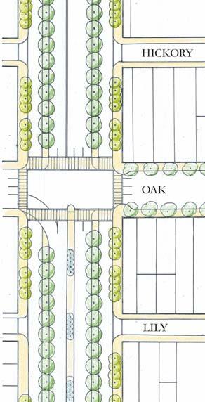
2 A1. Living Street Improvements for Select Alleys POLICY Introduce traffic-calming measures for residential alleys. Consider improvements to alleys with a residential character to create shared, multipurpose public space for the use of residents. Traffic calming can improve residential streets and alleys in a number of ways. Parking can be concentrated along the curbside with the fewest driveway breaks; new pedestrian-scaled lighting can be added; trees can be planted (if residents desire trees), with agreement on a single tree species and a unified planting pattern. Narrow traffic lanes are more conducive to slow vehicular movement than are wide lanes. Because these alleys carry relatively little traffic, they can be designed to provide more public space for local residents as a living street with corner plazas to calm traffic, seating and play areas for children, with space for community gardens and the like where people and cars share space. By calming traffic and creating more space for public use, the street can become a common front yard for public use and enjoyment. Working closely with DPT s Livable Streets traffic-calming program, prototypes should be developed for more extensive improvements to residential alleys. And a process should be developed whereby local residents can propose living-street improvements and participate actively in the design for their alley. Develop prototypes for residential alley improvements, to be used as part of the Livable Streets traffic-calming initiative. Develop a process whereby local residents can propose living street improvements and participate in the design and implementation of improvements to their alley. Figure 1. Schematic of Living Street Alleyway Concept DRAFT 01/10/2008 Appendix C -41
3 The following policy from the Market and Octavia Area Plan provides guidelines for Non-residential alley improvements. POLICY Consider making improvements to non-residential alleys that foster the creation of a dynamic, mixed-use place. Certain alleys support non-resident al uses. Coordinated approaches to the design of these alleys should protect the intimate scale of these alleys and yet create public space that contributes to and supports the varied uses along them. Enliven the ground floor space with active uses where possible. Loading spaces can be accommodated in ways that add to the character of the alley. Non-residential alleys can benefit from living street improvements that provide public open spaces that enhance the commercial uses. Encourage coordinate on throughout the alley by using similar or complementary details throughout. Create spaces that allow for the growth and evolution of uses. Non-resident al alleys may provide for a number of different and often conflicting uses. Reduce the conflict of uses by providing an uncluttered environment. Consider placing furnishings such as trash cans in a recessed area. DRAFT 01/10/2008 Appendix C -42
4 Church St Sanchez St Noe St Buchanan St APPENDIX C. Market and Octavia Community Improvements, Detailed and Costs February 2008 Turk St Golden gate Ave Laguna St Gough St Franklin St Elm St Redwood St Mcallister St Ash St Fulton St Birch St Larkin St Grove St Ivy St Polk St Hayes St Linden St Octavia Boulevard Hickory St Page St Haight St Laussat St Lily St Rose St Brady St Jessie St Colusa Pl Otis St Lafayette St 10th St Minna St 11th St Waller St Scott St Pierce St Steiner St Fillmore St Fell St Webster St Oak St Gough St Mccoppin St 12th St South Van Ness Ave 12th St Lloyd St Carmelita St Potomac St Hermann St Pink Aly Pearl St Webster St Elgin Park Stevenson St Plum St 13th St Duboce Ave Walter St Belcher St Reservoir St Rosemont Pl Clinton Park Brosnan St Stevenson St 14th St Henry St Ramona St Landers St Hidalgo Ter 15th St Sharon St Alert Aly 16th St Dolores St Guerrero St Valencia St Mission St Howard St Folsom St Market St Map 7 Alleys for "Living Street" Improvements Legend Alleys Public rights-of-way suitable for "living street" improvements ,600 Feet Meters Map 1 Alleys for "Living Street" Improvements DRAFT 01/10/2008 Appendix C -43
5 "LIVING STREETS IMPROVEMENTS" WOONERF STREETSCAPE SPACING (UNIT: LINEAR FEET PER ITEM) COST PER UNIT TOTAL Curb 1 $25 $30 Demo curb 1 $5 $5 Concrete curb ramp with truncated bulb outs 103 $3,000 $29 Benches 100 $1,500 $15 Tables 100 $1,500 $15 Shrubs (med) 5 $35 $7 Special trees 20 $2,000 $100 Tree grates 20 $850 $43 Trash bins 100 $600 $6 Drainage 410 $35,000 $85 Bollards 51 $1,800 $35 Signage 68 $100 $1 Ped lighting 40 $10,000 $250 cost/lf $622 TOTAL LINEAR FT AVERAGE COST PER LINEAR FOOT TOTAL COSTS Living Alleyways 31,867 $ $19,812,336 Soft Costs Subtotal $19,812,336 Soft Costs $13,208,224 Total $33,020,559 Department of Public Works Municipal Transportation Agency Mayor s Office of City Greening DRAFT 01/10/2008 Appendix C -44
6 A2. Street Tree Plantings POLICY Enhance the pedestrian environment by planting trees along sidewalks, closely planted between pedestrians and vehicles. Closely spaced and sizeable trees parallel and close to curbs, progressing along the streets to intersections, create a visual and psychological barrier between sidewalks and vehicular traffic, like a tall but transparent picket fence. More than any other single element, healthy street trees can do more to humanize a street, even a major traffic street. On many streets within the Market and Octavia neighborhood, successful environments can be created through aggressive tree infill, for example on Otis, Mission, Franklin, and Gough Streets north of Market Street. On other streets, such as Gough Street south of Market, Fell, and Oak Streets, and Duboce Avenue, it will mean major new tree planting. Consistent tree plantings make an important contribution to neighborhood identity. Different tree species can be used on different streets, or even different blocks of the same street, thereby achieving diversity on a broader basis. Rather than removing existing trees from any given street, the dominant tree species or preferred tree species on each block should be identified and future tree planting should be of that tree type. DRAFT 01/10/2008 Appendix C -45
7 Sanchez St Church St Franklin St Buchanan St APPENDIX C. Market and Octavia Community Improvements, Detailed and Costs February 2008 Turk St Golden gate Ave Laguna St Gough St Mcallister St Fulton St Larkin St Grove St Octavia Boulevard Polk St Hayes St Fell St Oak St South Van Ness Ave 10th St Page St 12th St Steiner St Fillmore St Webster St Haight St Gough St Mccoppin St Otis St 11th St Waller St Scott St Hermann St Howard St 13th St 12th St Duboce Ave 14th St 15th St 16th St Dolores St Guerrero St Valencia St Mission St S Van Ness Ave Folsom St Market St Noe St Tree Type Special Trees Special Trees (Long Term) Trees Map 2 Streets scheduled for intensive street tree plantings F ,600 Feet Meters DRAFT 01/10/2008 Appendix C -46
8 TYPICAL STREETSCAPE (EXCL. PAVING) SPACING (UNIT: LINEAR FEET PER ITEM) COST PER UNIT TOTAL Trees $43 Curb 1 30 $30 Demo curb 1 5 $5 Tree grates $43 Trash bins $6 Ped lighting 40 10,000 $250 Bench $8 cost/lf $384 SPECIAL STREETS (EXCL. PAVING) SPACING (UNIT: LINEAR FEET PER ITEM) COST PER UNIT TOTAL Trees special 20 2,000 $100 Curb 1 30 $30 Demo curb 1 5 $5 Tree grates $43 Trash bins $6 Ped lighting 40 10,000 $250 Bench $8 cost/lf $441 TOTAL LINEAR FEET AVERAGE COST PER LINEAR FOOT TOTAL COSTS typical tree scape improvements 11,444 $384 $4,388,774 special tree scape improvements 19,035 $441 $8,394,435 Subtotal $12,783,209 Soft Costs $8,522,139 Total $21,305,348 Department of Public Works Municipal Transportation Agency Mayor s Office of City Greening DRAFT 01/10/2008 Appendix C -47

9 A3. McCoppin Street Greening POLICY Redesign McCoppin Street as a linear green street with a new open space west of Valencia Street. With the new freeway touchdown, traffic accessing the freeway will no longer have the option of using McCoppin Street as a cut-through. As a result, the street will carry only a fraction of the traffic that it does today. Anticipating this change, there is the opportunity to reconfigure McCoppin Street from Otis to Valencia Streets as a linear green street, with a substantial portion of the vehicular rightof-way reclaimed as open space on the north side (the sunny side) of the street, and a calmed rightof-way for local traffic. The portion of McCoppin Street west of Valencia Street will no longer be needed for vehicular traffic, providing the opportunity for a small open space. The space, approximately 80 feet by 100 feet, would provide an excellent location for a small plaza or other form of community space for the use of local residents. DRAFT 01/10/2008 Appendix C -48
10 (B1) MCCOPPIN STREETSCAPE IMPROVEMENTS- CONCEPTUAL COST ESTIMATE, 2/15/2005 PROJECT COSTS NO. ITEM QUANTITY UNIT UNIT COST EXTENSION SUBTOTAL PLANNING $94,718 1 Planning Community Outreach (10% of total construction costs) 1 LS $85,402 $85,402 DESIGN $94,718 3 Design (10% of total construction costs) 1 LS $85,402 $85,402 CONSTRUCTION $947,182 S&H 4 Demolition 1 LS $50,000 $50,000 5 Asphalt Concrete Wearing Surface 275 TON $150 $41, Inch Thick Concrete Base 6,500 SF $10 $65, Inch Wide Combined Concrete Curb and 2- Foot Concrete Gutter 1,300 LF $40 $52, /2-Inch Thick Concrete Sidewalk 26,000 SF $8 $208, Inch Diameter VCP Sewer, Culverts, Sewer 9 Vents, and Base Over Sewer Concrete Catch basin with New Frame and 10 Grating 600 LS -- $150,000 2 EA $10,000 $20, Relocate Catch basin 3 EA $10,000 $30, Relocate Low-Pressure Fire Hydrant 2 EA $15,000 $30, Relocate Utilities for Sidewalk Widening 37 EA $2,000 $74, Typical Concrete Curb Ramp 17 EA $2,500 $42, Detectable Warning Surface 160 SF $60 $9, Inch Wide Concrete Curb at Curb Return 170 LF $30 $5, /2-Inch Thick Concrete Sidewalk at Curb Return 400 SF $8 $3, Relocate Utilities for Sidewalk Widening 37 EA $2,000 $74,000 DPT 19 Double Yellow Line 500 LF $4 $1, Raised Pavement Markers (white or Yellow) 22 EA $8 $ Parking Stalls 100 EA $20 $2,000 LA 22 36" Box Trees 50 EA $800 $40, " Root Barrier 1,200 LF $10 $12, Mulch 20 CY $50 $1, Irrigation System 8,900 SF $4 $35,600 CONTINGENCY 15% $142,077 TOTAL CONSTRUCTION COST AND CONTINGENCY $1,089,259 DRAFT 01/10/2008 Appendix C -49
11 CONSTRUCTION MANAGEMENT $217, Inspection (15% const. total & contingency cost) Construction Support (5% const. total & contingency cost) 1 LS $163,389 $163,389 1 LS $54,463 $54,463 ESTIMATE OF TOTAL PROJECT COST $1,496,547 : The closure of McCoppin Street west of Valencia Street is expected to reduce the amount of vehicular traffic on McCoppin Street between Valencia and Otis Street. This proposal, also part of DPT's Livable Streets Program, would reduce the n Department of Public Works Municipal Transportation Agency Mayor s Office of City Greening DRAFT 01/10/2008 Appendix C -50


12 A4. Brady Park POLICY Make pedestrian improvements within the block bounded by Market, Twelfth, Otis, and Gough Streets and redesign Twelfth Street between Market and Mission Streets, creating a new park and street spaces for public use, and new housing opportunities. The block bounded by Market, Gough, Otis and 12th Streets, known as the "Brady Block" is a unique place, in that its interior is divided and made publicly-accessible by four different alleys bisecting it in different directions. At its core, the block shows the signs of many years of neglect; surface parking lots and a large ventilation shaft for the BART system create a large swath of undefensible space. The block has tremendous potential despite its present conditions. It is an intimate space of small buildings facing on narrow alleys. It isn't hard to envision a small neighborhood here-on the scale of Southpark: small residential infill and existing buildings framing a new public park at the core of the block's network of alleys. The addition of new housing and the development of a small-scaled living area with a narrow but connected street pattern can make this an enviable mini-neighborhood. Existing uses can stay, but new uses can, by public and private cooperation, create a residential mixed-use enclave. A small new open space can be developed in the center of the Brady Block, taking advantage of a small, approximately 80-foot-square BART-owned parcel that provides access to its tunnel below, and through purchase, an additional 100 foot by 80 foot parcel, currently surface parking. By creating a small open space here and connecting the existing alley network, the city would have created a magnificent centerpiece for this intimate mini-neighborhood. The park will be surrounded by several housing opportunity sites and would by accessed via a network of mid-block alleys designed as "living street" spaces, in accordance with policies for residential alleys outlined in Element 3 of the Neighborhood Plan. The BART vent shaft rather than a hindrance, could be the site of a central wind driven, kinetic sculpture. DRAFT 01/10/2008 Appendix C -51
13 BRADY PARK NEED UNIT COST PER UNIT COST land cost 11,800 sf $80 $944,000 open space (soft) 13,000 sf $20 $263,250 Lawn 7,500 sf $ Irrigation 10,000 sf $6 $60,000 benches 6 each $1,500 $9,000 tables 2 each $1,500 $3,000 shrubs (large) 30 each $150 $4,500 trees 15 each $850 $12,750 brick paving 1,500 sf $40 $60,000 soil 333 cubic yard $40 $13,320 drinking fountain 1 each $4,500 $4,500 pedestrian lighting 8 each $10,000 $80,000 Subtotal $1,476,820 Soft Costs $984, Total $2,461,367 Recreation and Parks Department Department of Public Works Mayor s Office of City Greening Department of Real Estate Planning Department DRAFT 01/10/2008 Appendix C -52

14 A5. McCoppin Plaza Phase I POLICY Create new public open spaces around the freeway touchdown, including a plaza on Market Street and a plaza in the McCoppin Street right-of-way, west of Valencia Street. Bringing the freeway down to ground south of Market Street offers the opportunity to created two new small public open spaces: a plaza along Market Street west of the freeway touchdown, and a plaza or other form of small open space within the closed last block of McCoppin Street, west of Valencia Street. The plaza on Market Street will enhance the pedestrian experience of the street, and facilitate safer pedestrian crossings. Because of its prominent location at the end of the freeway and beginning of Octavia Boulevard, it should be designed with elements that signal an entry to the city, including seating, trees and other pedestrian amenities. The leftover space on McCoppin Street is an appropriate place for a community-serving open space, integrated into the overall green street treatments proposed for McCoppin Street east of Valencia Street, as well as the proposed bikepath on the east side of the touchdown. The triangular parcel immediately south of the McCoppin Street right-of-way, currently serving as a truck-rental office, could be part of a larger open space at this location. DRAFT 01/10/2008 Appendix C -53
15 (D1) MCCOPPIN COMMUNITY PARK -CONCEPTUAL COST ESTIMATE, 2/15/2005 PROJECT COSTS NO. ITEM QUANTITY UNIT UNIT COST EXTENSION SUBTOTAL PLANNING $55,368 1 Community Outreach (7% of Const. Cost) 1 LS $38,758 $38,758 2 Project Development (3% of Const. Cost) 1 LS $16,610 $16,610 DESIGN $55,368 3 A&E services (10% Total Construction Cost) 1 LS $55,368 $55,368 CONSTRUCTION $553,680 4 Demolition 1 LS $20,000 $20,000 5 Hazardous Material Assessment & Abatement 900 Tons $50 $45,000 6 Import Fill 671 CY $80 $53,680 7 Grading and Drainage 1 LS $35,000 $35,000 8 Landscape Construction 1 LS $300,000 $300,000 9 Planting and Irrigation 1 LS $100,000 $100,000 CONTINGENCY 15% $83,052 TOTAL CONSTRUCTION COST AND CONTIGENCY $636,732 CONSTRUCTION MANAGEMENT $127, Inspection (15% total const. & contingency cost) Construction Support (5% total const. & contingency cost) 1 LS $95,510 $95,510 1 LS $31,837 $31,837 ESTIMATE OF TOTAL PROJECT COST $874,814 : When the new Central Freeway touches down at Market Street, McCoppin Street west of Valencia Street will no longer connect with Market Street. The proposal for the resulting right-of-way cul-de-sac is to convert the roadway into a secured community park, approximately 7,210 square feet. This particular estimate includes a community garden including low terraces conforming to the existing slope. The design of the community park will be coordinated with the proposed bike lane connecting Valencia Street with Market Street and Octavia Boulevard. Recreation and Parks Department Department of Public Works Municipal Transportation Agency Mayor s Office of City Greening DRAFT 01/10/2008 Appendix C -54
16 A6. McCoppin Plaza Extension Phase II Following Policy reprinted on page 53, this project explores as a long term strategy the possibility of acquiring lot west of Valencia Street, currently owned by U-haul, with the purpose of using the site as an addition to the McCoppin Community Park. MCCOPPIN STUB EXTENSION AND IMPROVEMENTS NEED UNIT COST PER UNIT COST acquisition of lot ,929 sf $ $591,432 greening of lot 4,929 sf $80.00 $626,001 Subtotal $1,217,433 Soft Costs Total $2,029,055 Recreation and Parks Department Department of Public Works Municipal Transportation Agency Mayor s Office of City Greening DRAFT 01/10/2008 Appendix C -55

17 A7. Patricia s Green Hayes in Hayes Valley Completed Project Costs $1,500,000 Source: Ramon Kong, DPW Park and Recreation Department Caltrans Department of Public Works Municipal Transportation Agency San Francisco County Transportation Agency DRAFT 01/10/2008 Appendix C -56
18 A8. Under Freeway Park Use the Caltrans parcels beneath the new Central Freeway structure for uses other than parking (unless parking revenue could fund additional maintenance of ancillary projects), such as recreational open space (for example, a dog run) and/or temporary structures housing cultural arts programs. CENTRAL FREEWAY - SITE WORK CONCEPTUAL COST ESTIMATE (12/15/05) ITEM QUANTITY UNIT UNIT COST COST SUBTOTAL Parcel A $740,200 Skatepark Equipment (Area:15,750 SF) 1 LS 500,000 $500,000 Fencing 970 LF 150 $145,500 Pathway Colorcoat 2,950 SF 2 $5,900 Double Gates 6 EA 1,800 $10,800 Lighting 13 EA 6,000 $78,000 Parcel B $444,650 Basketball Court/Play Area Colorcoat 15,000 SF 2 $30,000 Pathway Colorcoat 3,200 SF 2 $6,400 Dog Park Surfacing 8,500 SF 2 $17,000 Fencing 1,055 LF 150 $158,250 Single Gates 8 EA 2,000 $16,000 Double Gates 2 EA 3,000 $6,000 Sliding Gates 2 LS 8,000 $16,000 Basketball Backboards 3 EA 5,000 $15,000 Lighting 18 EA 6,000 $108,000 Seat Wall 480 LF 150 $72,000 MISC $10,000 ADA Improvements (curb ramps at Stevenson) 1 LS 10,000 $10,000 Subtotal $1,200,000 20%Contingency $240,000 Construction Cost $1,440,000 A/E & Construction Management Services (35% Construction) $504,000 Maintenance Cost 3 Year $80,000 $240,000 $240,000 Total Project Cost $2,184,000 Department of Public Works Caltrans Municipal Transportation Agency Recreation and Parks Department San Francisco County Transportation Agency Mayor s Office of Economic and Workforce Development DRAFT 01/10/2008 Appendix C -57
19 A9. Hayes Green Rotating Art Project The community and the San Francisco Arts Commission has identified Hayes Green as a wonderful opportunity to feature a variety of temporary public art pieces. David Best s temple, which was temporary by design, certainly influenced the community s dedication to this very progressive method of selecting art for public spaces. Strategey HAYES GREEN ROTATING ART PROJECT - PER YEAR NEED UNIT COST PER UNIT COST Acquisition 2 piece $50,000 $100,000 Insurance 2 piece $15,000 $30,000 Re-habilitation 2 piece $10,000 $20,000 Subtotal $150,000 Soft Costs $100,000 Total $250,000 San Francisco Arts Council Department of Public Works Recreation and Parks Department DRAFT 01/10/2008 Appendix C -58
20 A10. Improvements to Existing Parks Make necessary improvements to existing parks, such as the addition of recreational facilities or other ammenities, additional landscaping programs, and activation of the space. Strategey TBD Planning Department Recreation and Parks Department DRAFT 01/10/2008 Appendix C -59


21 A11. Octavia Boulevard Completed DRAFT 01/10/2008 Appendix C -60
22 Project Cost CENTRAL FREEWAY - OCTAVIA BOULEVARD PROJECT PROJECT ELEMENTS: COST Preliminary engineering $300,000 Project Management $3,200,000 Land Management $2,600,000 Traffic Management Plan $6,900,000 Traffic System Management $6,000,000 Octavia Blvd Design $1,300,000 Public Art $250,000 Octavia Blvd Construction $13,000,000 Oak Street Resurfacing $450,000 Octavia Blvd Construction Mngt. $1,600,000 Octavia Blvd Design Support $424,000 Archeology $1,200,000 VanNess Ave. Resurfacing $5,850,000 Ancillary Projects $5,500,000 Octavia Blvd Maintenance $750,000 TOTAL PROJECT COST $49,324,000 Hayes Green $(1,500,000) Octavia Boulevard - Recently Built $47,824,000 Source: Ramon Kong, DPW Caltrans Department of Public Works Municipal Transportation Agency Recreation and Parks Department San Francisco County Transportation Agency DRAFT 01/10/2008 Appendix C -61
23 A12. Immediate Freeway Mitigation Install 6 trees at Freeway touchdown. Install Sculpture at Market Street Install lighting below freeway at Valencia and other key pedestrian areas. FREEWAY MITIGATION NEED UNIT COST PER UNIT COST Trees for Highway touchdown 6 ea $2, $12, slender sculpture or column for market and highway 1 ea $223,000 $223,000 lighting for below the freeway 16 ea $10, $160,000 other Subtotal $395,000 Soft Costs $263,333 Total $658,333 San Francisco County Transportation Agency Department of Public Works Municipal Transportation Agency Recreation and Parks Department Mayor s Office of Economic and Workforce Development Caltrans DRAFT 01/10/2008 Appendix C -62
24 A13. Study Central Freeway 1. Evaluate the impacts of traffic flow from new Central Freeway. 2. Consider the further dismantling of the Central Freeway. $200,000 San Francisco County Transportation Agency Planning Department Caltrans Municipal Transportation Agency Mayor s Office of Economic and Workforce Development DRAFT 01/10/2008 Appendix C -63
25 A14. Hayes Street Two Way Project Reorganize east-west traffic in Hayes Valley to reduce pedestrian conflicts and eliminate confusing Z-shaped jogs of one way traffic. One-way streets encourage fast-moving traffic, disrupt neighborhood commercial activities, and negatively affect the livability of adjacent uses and the neighborhood as a whole. Construction of Octavia Boulevard makes it unnecessary for one-way Oak Street traffic to be routed east of Van Ness Avenue via Franklin Street, or westbound Fell Street traffic to come from the east via Hayes Street and Gough Street. This reorganization will greatly simplify traffic patterns, make street crossings for pedestrians safer, and return Hayes Street to a two-way local street, which is best suited to its commercial nature and role as the heart of Hayes Valley. TBD Municipal Transportation Agency San Francisco County Transportation Agency Planning Department DRAFT 01/10/2008 Appendix C -64
26 A15. Improve Safety of City Parking Garages Access and personal safety improvements should be made to the Civic Center Garage to serve patrons of area cultural institutions. (Draft Plan, p. 120) IMPROVE SAFETY AND ACCESSIBILITY OF CITY PARKING NEED UNIT COST PER UNIT COST lights 4 $10, $40,000 cameras/staff Subtotal $40,000 Soft Costs $26,667 Total $66,667 Parking Authority Municipal Transportation Agency Mayor s Office of Economic and Workforce Development DRAFT 01/10/2008 Appendix C -65
27 A16. Parking Supply Survey and Analysis Parking Inventory Survey Objectives: 1. Take inventory of on and off street parking stock in the plan area, this data should serve as a base for the plan monitoring effort as well as informing further analysis of parking management strategies. 2. Research the implementation of on street parking management strategies, especially parking benefits districts, and residential parking permit reform. Make specific policy recommendations that consider administration of the program, social justice issues, economic impacts of programming on individuals and the neighborhood, and impacts on the transportation networks. Develop executable implementation strategies which identify agency, procedures, and an approval strategy. 3. Study mechanisms to re-capture the impacts of off street parking in the neighborhood and curb cuts, especially associating additional parking with housing unit based transit passes. Survey like programs, suggest an implementation strategy and agency. Estimated Cost: $300,000 Cost estimate is 4 times the budget allocated for the Transit Authorities Parking Benefits District Survey. This Study should first survey the existing parking supply, second pursue the development of three programs: Residential Parking Permit Reform, Parking Benefits Districts, Parking Transit Impact Program, and Curb Cut Impact Fee Program. Planning Department Municipal Transportation Agency San Francisco County Transportation Agency DRAFT 01/10/2008 Appendix C -66
28 A17. Pedestrian Improvements for Priority Intersections POLICY Widen sidewalks and shorten pedestrian crossings with corner plazas and boldly marked crosswalks. On streets throughout the plan area, there is a limited amount of space on the street to serve a variety of competing users. Many streets have more vehicular capacity than is needed to carry peak vehicle loads. In accordance with the city s Transit-First Policy*, street right-of-way should be allocated to make safe and attractive places for people and to prioritize reliable and effective transit service even if it means reducing the street s car-carrying capacity. Where there is excessive vehicular capacity, traffic lanes should be reclaimed as civic space for widened sidewalks, plazas, and the like. The plan calls for full buldbouts on every corner at identified intersections. Bulbouts are planned at 42 intersections for 179 corners. Map below identifies specific corners. DRAFT 01/10/2008 Appendix C -67

29 DRAFT 01/10/2008 Appendix C -68
30 The Market and Octavia Plan calls for pedestrian improvements at 42 intersections. The Department of Public Works generated site specific cost estimates [ see Site Specific Cost Estimates column in table on next page] for nearly half of these intersections as part of the Central Freeway Ancillary Project effort. From these site specific cost estimates, the Planning Department estimated the average cost of bulbouts for one corner to be just over $48,000. Project cost estimates for the remaining identified intersections was estimated based on this cost [Average Cost Estimates column]. STREET1 STREET2 STREET3 NUMBER OF CORNERS AT THE INTERSECTION COST ESTIMATE FROM SITE SPECIFIC COST ESTIMATE COST ESTIMATE FROM AVERAGE COST PER CORNER ESTIMATED COST A17.1 Otis Gough McCoppin 4 $213,271 $213,271 A17.2 Mission S Van Ness 12th Street 6 $654,400 $654,400 A17.3 Van Ness Market S Van Ness 5 $199,088 $199,088 A17.4 Van Ness Fell 4 $43,136 $43,136 A17.5 Market Sanchez 15th Street 4 $194,814 $194,814 A17.6 Market Church 14th Street 6 $292,220 $292,220 A17.7 Buchanan Fell 4 $232,760 $232,760 A17.8 Buchanan Oak 4 $165,560 $165,560 A17.9 Buchanan Market Duboce 5 $118,576 $118,576 A17.10 Laguna Fell 4 $83,870 $83,870 A17.11 Laguna Oak 4 $172,185 $172,185 A17.12 Laguna Market 5 $184,797 $184,797 A17.13 Octavia Fell 4 $194,814 $194,814 A17.14 Octavia Oak 4 $194,814 $194,814 A17.15 Octavia Market 5 $243,517 $243,517 A17.16 Gough Turk 4 $194,814 $194,814 A17.17 Gough Golden Gate 4 $194,814 $194,814 A17.18 Gough McAllister 4 $194,814 $194,814 A17.19 Gough Fulton 4 $194,814 $194,814 A17.20 Gough Grove 4 $194,814 $194,814 A17.21 Gough Hayes 4 $344,846 $344,846 A17.22 Gough Fell 4 $194,035 $194,035 A17.23 Gough Oak 4 $194,814 $194,814 A17.24 Gough Page 4 $211,296 $211,296 A17.25 Gough Market 4 $299,897 $299,897 A17.26 Franklin Turk 4 $194,814 $194,814 A17.27 Franklin Golden Gate 4 $194,814 $194,814 A17.28 Franklin McAllister 4 $194,814 $194,814 A17.29 Franklin Fulton 4 $194,814 $194,814 A17.30 Franklin Grove 4 $194,814 $194,814 A17.31 Franklin Hayes 4 $276,846 $276,846 A17.32 Franklin Fell 4 $215,910 $215,910 A17.33 Frankllin Oak 4 $169,537 $169,537 A17.34 Franklin Page Market 5 $297,747 $297,747 A17.35 Mission Duboce 13th Street 5 $117,616 $117,616 A17.36 Mission 10th Street 4 $196,687 $196,687 A17.37 Mission 11th Street 4 $330,171 $330,171 A17.38 South Van Ness Howard Division 4 $194,814 $194,814 DRAFT 01/10/2008 Appendix C -69
31 A17.39 Polk Market 5 $117,786 $117,786 A17.40 Noe Market 16th 4 $194,814 $194,814 A17.41 Larkin Market 9th 4 $194,814 $194,814 A17.42 Herman Steiner 4 $194,814 $194,814 Subtotal 179 $4,840,017 $4,042,380 $8,882,397 Soft Costs $5,921,598 Total $14,803,995 Table uses estimated costs per corner based on costs in ancillary projects. The estimation error means that there are "observed" estimates in the ancillary projects which we allow to override the "average" cost per corner. Therefore, there is an error term. Department of Public Works Municipal Transportation Agency Planning Department Mayor s Office of Greening DRAFT 01/10/2008 Appendix C -70
32 A18. Extend Octavia ROW to Golden Gate POLICY Re-introduce a public street along the former line of Octavia Street, between Fulton Street and Golden Gate Avenue. Damage done to the San Francisco grid by landassembly projects of the 1960 s and 1970 s can be partially repaired through the reestablishment of Octavia Street as a public right-of-way from Fulton Street to Golden Gate Avenue, providing improved access to existing housing developments, helping to knit them back into the areas south of Fulton Street, and providing a green connection between the new Octavia Boulevard and Jefferson Park and Hayward Playground. Bicycle movement in a north-south direction would also be improved by this policy. REINTRODUCE PUBLIC RIGHT OF WAY ON OCTAVIA BETWEEN FULTON AND GOLDEN GATE NEED UNIT COST PER UNIT COST land acquisition 11,485 sf $60.00 $689,105 site prep 11,485 sf $2.00 $22,970 signage 2 blocks $1, $3,200 create sidewalks/streetscape 275 lf $ $105,463 paving 7,700 sf $20.00 $154,000 Subtotal $974,737 Soft Costs $649,825 Total $1,624,562 Land cost is assumed comparatively low relative to price/square foot otherwise found in plan area because of the vacant and for the time being non-buildable nature of the site. Department of Public Works San Francisco Redevelopment Agency Planning Department DRAFT 01/10/2008 Appendix C -71
33 A19. Market Street & Church or Van Ness Muni Entrances POLICY Improve BART and Muni entrances and exits to give them a sense of identity and make them less intrusive on sidewalk space. The very wide BART and Muni entrances and the sidewalks behind them, presently somewhat moribund and hard to recognize, offer opportunities for Market Street: to create more visible entranceways with modest vertical elements and to create small open spaces with sitting areas, integrated news-vending boxes, pedestrian lighting, and information and sales kiosks. MARKET AND VAN NESS & CHURCH: BART AND MUNI ENTRANCES NEED UNIT COST PER UNIT COST identity markers 6 piece $200,000 $1,200,000 lighting 8 light $10,000 $80,000 Subtotal $1,280,000 Soft Costs $853,333 Total $2,133,333 Municipal Transportation Agency Department of Public Works San Francisco County Transportation Agency Mayor s Office of Economic and Workforce Development Planning Department DRAFT 01/10/2008 Appendix C -72


34 A20. Widen Hayes Street Sidewalk POLICY Widen the sidewalk on the northern side of Hayes Street, between Franklin and Laguna Streets, to create a linear pedestrian thoroughfare linking commercial activities along Hayes Street to the new Octavia Boulevard. Hayes Street is a special commercial street within the neighborhood. It is at once locally-focused, with small cafes and restaurants, and citywide focused, with its numerous galleries and proximity to cultural institutions in the Civic Center. It is often alive with pedestrian activity. Between Franklin and Laguna Streets, where traffic rerouting policies suggested in Element 5 allow a return to two-way traffic, the roadway is wider than it needs to be. Widening the sidewalk on the north side of the street, planting new trees, and installing new pedestrian-scaled light fixtures and benches will create a much needed public open space and lend additional grace to the street. Café seating should be allowed to spill out onto the widened sidewalk. The sidewalk widening should not adversely affect turning movements for Muni buses. DRAFT 01/10/2008 Appendix C -73
35 WIDEN HAYES STREET SIDEWALK NEED UNIT COST PER UNIT COST Demo 43, SF $2 $87, /2-Inch Thick Concrete Sidewalk 27,703.5 SF $10 $277,035 6-Inch Wide Concrete Curb 1, LF $45 $80,494 8-Inch Thick Concrete Parking Strip and Gutter 16, SF $11 $177,086 Concrete Curb Ramp with Truncated Bulb Outs Concrete Curb Ramp with Truncated Other Corners 3 EA $2,000 $6, EA $4,000 $42,000 Install Tree and Tree Grate EA $2,000 $82,500 Relocate Catch basin 6 EA $9,000 $54,000 Relocate High Pressure Fire Hydrant 1.5 EA $50,000 $75,000 Relocate Low Pressure Fire Hydrant 2.25 EA $10,000 $22,500 New Light Pole/Strain Pole 3 EA $10,000 $30,000 New Light Pole, Mast Arm, or Traffic Signal 7.5 EA $20,000 $150,000 New Light Pole 16.5 EA $8,000 $132,000 New Trash Receptacles 6 EA $2,000 $12,000 New Bike Rack/Art Enrichment 18 EA $2,000 $36,000 Relocate Utility Boxes, Traffic Signs, Parking Meters ALLOW $105,000 Traffic Control 0.5 $136,922 $68,461 Subtotal $1,437,680 Soft Costs $958,454 Total $2,396,134 Department of Public Works Municipal Transportation Agency San Francisco County Transportation Agency Planning Department DRAFT 01/10/2008 Appendix C -74


36 A21. Dolores Street Median Extension Dolores Street has special historic significance to the people of San Francisco and is one of the most visually memorable streets in the city, because of its palm-tree-lined central median. The intersection of Dolores Street and Market Street should be celebrated by extending the median to Market Street and creating a small paved plaza in front of the statue for people to meet, talk, and sit, and by announcing this significant city street, the location of Mission Dolores. Over the years, it may be expected that the large property bordering the west side of this block of Dolores Street will be redeveloped, privately, with housing and commercial uses that will be made all the more attractive by this improvement. DOLORES STREET MEDIAN EXTENSION NEED UNIT COST PER UNIT COST Median extension 4 bulbouts $48,703 $194,812 Bollards 17 bollards $800 $13,600 Subtotal $208,412 Soft Costs $138,941 Total $347,353 The cost to extend the median is estimated from the cost of a bulbout construction. Department of PublicWorks Planning Department DRAFT 01/10/2008 Appendix C -75


37 A22. Re-establishment of Select Alleyways POLICY Do not allow the vacation of public rights-of-way, especially alleys. Where new development creates the opportunity, extend the area s alley network. Pursue the extension of alleys where it would enhance the existing network: Purchase the easternmost portion of Plum Alley that is in private ownership. Pursue the extension of Stevenson Alley from Gough Street to McCoppin Street as part of any proposal for demolition and new construction on parcel Further, as a part of this effort: Parcel , which is currently vacant, will have to be purchased and dedicated to Department of Public Works as a public right-of-way connecting Stevenson Alley with Colton and Colusa Alleys. Approximately 4,000 sf. of parcel , which is currently a surface parking lot, will have to be purchased and dedicated to Department of Public Works as a public right-of-way connecting the two disconnected halves of Stevenson Alley. The alleys differ with respect to how ready they are for right-of-way reconnection. Some are vacant, whereas some still have structures. It should be stressed that in those cases, the reconnection is a long-range policy to be triggered whenever there is a proposed change to the building on the site. DRAFT 01/10/2008 Appendix C -76

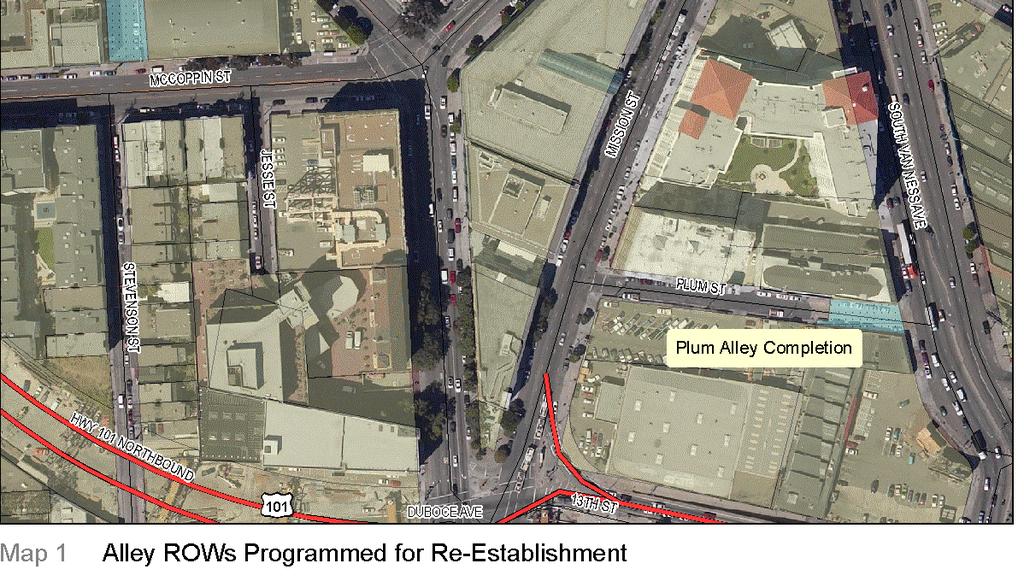
38 DRAFT 01/10/2008 Appendix C -77
39 ALLEYWAY RECONNECTIONS Brady Block Connect Stevenson with Colton and Colusa NEED UNIT COST PER UNIT COST Purchase vacant parcel ** 2,787 sf $80 $0 Development of streetscape 100 lf $379 $37,850 Brady Block Stevenson Alley Re-connection Purchase 4000sf of parcel to connect Stevenson alley Concrete paving 2,787 sf $20 $55,740 Catch Basins 2 each $6,000 $12,000 Sewer Manhole 1 manhole $6,000 $6,000 Culvert (Pipe) 100 lf $150 $15,000 Captial Costs $126,590 Soft Costs $84,393 Project Total $210,983 4,000 sf $80 $0 Development of streetscape 180 lf $ Stevenson to Mccoppin Alley Re-connection Concrete paving 4,000 sf $20 $80,000 Catch Basins 4 each $6,000 $24,000 Sewer Manhole 2 manhole $6,000 $12,000 Culvert (Pipe) 200 lf $150 $30,000 Captial Costs $214,130 Soft Costs $142,753 Project Total $356,883 Purchase portion of parcel ** 9725 $0 Development of streetscape 460 lf $379 $174,110 Concrete paving 9725 sf $20 $194,500 Purchase of right of way 3225 sf $50 $161,250 Development of streetscape 0 lf $379 $0 Concrete paving 0 sf $20 $0 Catch Basins 4 each $6,000 $24,000 Sewer Manhole 2 manhole $6,000 $12,000 Culvert (Pipe) 200 lf $150 $30,000 Captial Costs $595,860 Soft Costs $397,240 Project Total $993,100 DRAFT 01/10/2008 Appendix C -78
40 Plum Alley Completion Purchase of Right of Way 3225 sf $50 $161,250 Development of streetscape 0 lf $379 $0 Concrete paving 9725 sf $20 $194,503 Purchase of right of way 3225 sf $50 $161,250 Development of streetscape 0 lf $379 $0 Capital Costs $517,003 Soft Costs $344,669 Project Total $861,672 ** Included as costs in the Brady Block Community Park Estimate. Total $2,422,638 Department of Public Works Planning Department Municipal Transportation Agency DRAFT 01/10/2008 Appendix C -79
41 A23. Van Ness Bus Rapid Transit Project Implement Bus Rapid Transit program for Van Ness Avenue from Mission Street to Hayes Street. San Francisco County Transportation Agency Municipal Transportation Agency DRAFT 01/10/2008 Appendix C -80
42 A24. Transit Preferential Streets Time the lights from Duboce Avenue to The Embarcadero precisely according to the length of time it takes for Muni to board passengers then travel to the next intersection. Consider reverting to the signal timing prior to the Loma Prieta earthquake. Use a colored asphalt overlay, typically red, and signage to make transit lanes clearly identifiable. Implement transit preferential treatments, such as stop sign removal and signal preemption/ prioritization, on bus route streets such as Haight/Page, Hayes, Fillmore/Church and Mission Streets. (DPT, Muni) Implement transit preferential treatments outside the neighborhood along the J, K, L, M and N lines, 22 line, and entire Haight Street and Mission Street corridors to improve frequency and capacity within it. (DPT, Muni). TRANSIT PREFERENTIAL STREETS NUMBER OF INTERSECTIONS COST PER FIXTURE TOTAL Install Transit preferential signals 33 $150,000 $4,950,000 Install signs $19,800 Subtotal $4,969,800 Soft Costs $3,313,200 Total $8,283,000 DRAFT 01/10/2008 Appendix C -81

43 DRAFT 01/10/2008 Appendix C -82
44 Municipal Transportation Agency San Francisco County Transportation Agency Department of Public Works Planning Department DRAFT 01/10/2008 Appendix C -83
45 A25. Dedicated Transit Lanes Transit-only lanes should be created on Duboce Avenue just west of Church Street to speed passenger boarding at the stops there. Transit-only lanes should be created along the four-lane segment of Church Street between Duboce Avenue and 16 th Street, ensuring that the J and 22 lines will not have to wait more than a single traffic-light cycle. Implement enforceable transit-only lanes on Market Street east of Octavia Boulevard and Mission Street north of 16th Street. (DPT, Muni) Seek legislation for video enforcement of transit only lanes. (State legislative delegation) Implement dedicated bus lanes on Van Ness Avenue for Muni and Golden Gate Transit. (DPT, Muni, Caltrans). See map for item A24. Dedicated Transit Lanes $2,990,000 Soft Costs $1,993,333 Total $4,983,333 Municipal Transportation Agency San Francisco County Transportation Agency Department of Public Works Planning Department DRAFT 01/10/2008 Appendix C -84


46 A26. Church Street Improvements POLICY Enhance the transit hub at Market and Church Street. The length of Church Street from Market Street to Duboce Avenue is one of the city s most important transit centers. It is the transfer point between the Muni Metro and several surface bus and streetcar lines. It is also a center of neighborhood activity, with large volumes of pedestrian and bicycle traffic at all times of the night and day. Despite its importance, the area lacks all but the most basic pedestrian amenities. Relatively simple improvements would dramatically enhance pedestrian and transit rider comfort in the area, making transit a more attractive travel option. Church Street, north of Market Street, can be re-designed as a pedestrian- oriented transit boulevard with the center reserved for streetcars, but with auto travel still permitted to the right and left. The opportunity for an enhanced streetcar-loading platform on Duboce Street, west of Church Street, exists as well. When these transit-preferential treatments are installed, care should be taken to ensure safe and comfortable pedestrian connections to transit facilities and to accommodate bicycle traffic on Duboce Street. Church Street, south of Market Street, features wide sidewalks. The intersection should receive special light fixtures, and the streetcar platform shelters could receive a special Market Street design. DRAFT 01/10/2008 Appendix C -85
47 QUANITY UNIT COST PER UNIT TOTAL Extend Median on Market (east) 4 bulbouts $48,703 $194,812 Extend Median on Market (west) 6 bulbouts $48,703 $292,218 Reconfigure church street platform (North of Market) Reconfigure church street platform (South of Market) 4 bulbouts $48,703 $194,812 4 bulbouts $48,703 $194,812 Reconfigure Duboce Street Platform 6 bulbouts $48,703 $292,218 Drainage 20 each $35,000 $700,000 Trees 24 each $2,000 $48,000 Tree grates 24 each $850 $20,400 Transit Shelters 2 each $200,000 $400,000 Lighting 8 each $10,000 $80,000 Crosswalk enhancements 10 each $3,000 $30,000 Bench 6 each $1,500 $9,000 Signage 12 each $150 $1,800 Bollards 72 each $1,800 $129,600 Traffic Study 0.10 of total costs $191,687 Subtotal $2,779,359 Soft Costs $1,852,906 Total $4,632,265 Municipal Transportation Agency San Francisco County Transportation Agency Department of Public Works Planning Department DRAFT 01/10/2008 Appendix C -86
48 A27. Neighborhood Fast Pass Provide transportation passes for residents of new housing to encourage the use of accessible transportation for commuting and daily trips. Establishment of this program would require additional work, as discussed in the Future Impact Fees section of the program document within the Parking Impact Fees section. Planning Department projects that the program could generate transit passes for nearly 1,500 households for at least a six-year period. This program is valued at nearly $4.5 million dollars. This estimate assumes that program development requires a maximum of two years. Neighborhood Fast Pass $4,470,000 Administration $447,000 Total $4,917,000 1/4 of new units (5,960) times 3,000 Municipal Transportation Agency Department of Public Works San Francisco County Transportation Agency Planning Department DRAFT 01/10/2008 Appendix C -87
49 A28. Transit User Infrastructure Provide necessary infrastructure for transit users as identified in future community processes. TBD. Municipal Transportation Agency Department of Public Works San Francisco County Transportation Agency Planning Department DRAFT 01/10/2008 Appendix C -88
50 A29. Transit Services Adequate transportation services are integral to the successful implementation of the Market and Octavia Plan. The plan does not call for specific service and operation improvements but supports Municipal Transportation Agency and San Francisco County Transportation Authority s work to pursue the appropriate levels of service. Specific projects and related studies will be identified and developed through MTA s long range planning efforts, the Transportation Effectiveness Project (TEP), and related transportation planning efforts. Projects should be pursued in coordination with growth in the plan area. Municipal Transportation Agency San Francisco County Transportation Agency Planning Department DRAFT 01/10/2008 Appendix C -89
51 A30. Bicycle Network Improvements POLICY Improve bicycle connections, accessibility, safety, and convenience throughout the neighborhood, concentrating on streets most safely and easily traveled by cyclists. In addition to being a major crossroads for transit and automobile traffic, the Market and Octavia neighborhood includes several of the most important and well-used bicycle routes in the city. All streets in the study area should be designed to be safe for bicycles, the following corridors merit special attention: Market Street Valencia Street and the Freeway Touchdown Duboce Avenue Howard Street DRAFT 01/10/2008 Appendix C -90

52 DRAFT 01/10/2008 Appendix C -91
53 Street Distance Cost Market Street, 16th to Complete bike lanes and Rose/Brady Street add signals as needed 4,090 $ 295,000 Polk Street Contraflow lane 1,480 $ 200,000 Dedicated bike lane van Otis/McCoppin Street ness to McCoppin stub 2,450 $ 20,000 McCoppin Stub Complete Bike Lanes $ 4,750 11th Street Sharrows 1,300 $ 867 Grove Street Sharrows 2,900 $ 3,867 Sanchez Street Sharrows 2,625 $ 3,500 Steiner Street Sharrows 630 $ 840 Subtotal $528,823 Soft Costs $352,549 Total $881,372 Municipal Transportation Agency Department of Public Works DRAFT 01/10/2008 Appendix C -92
54 A31. Muni Bike Racks POLICY Support and expand opportunities for bicycle commuting throughout the city and the region. Bicycle commuting reduces peak-period commutes by car and has a markedly positive effect in reducing traffic congestion. From a citywide and regional perspective, every effort should be made to support peoples commute by bicycle. The largest obstacle to bicycle commuting, aside from unsafe streets, is the difficulty in taking bicycles on regional transit and the lack of secure bicycle parking at transit facilities. To support bicycle commuting, bicycles need to be permitted on all regional transit operators at peak commute times and secure bicycle parking needs to be provided at regional transit stations. Allow bicycles or provide bike racks on all Muni vehicles. BIKE BUS RACKS QUANITY UNIT COST PER UNIT TOTAL Sportswor ks racks 30 $600 $18,000 installation 30 $200 $6,000 Subtotal $24,000 Soft Costs $16,000 Total $40,000 Municipal Transportation Agency DRAFT 01/10/2008 Appendix C -93
55 A32. On-Street Bike Racks POLICY Provide secure and convenient bicycle parking throughout the plan area. Providing bicycle parking is important to "closing the loop" in making cycling an attractive alternative to driving. In urban areas like San Francisco, secure and convenient bicycle parking, placed in appropriate locations, is an essential amenity for everyday cyclists. Such bicycle parking reduces theft and provides a needed sense of security. Building on DPT's bicycle parking program, ensure that adequate bicycle parking is provided in centers of activity such as Hayes Street, Market Street, and the new Octavia Boulevard. Require a minimum amount of bicycle parking on-site for any new development that includes automobile parking. QUANITY UNIT COST PER UNIT TOTAL Bicycle parking on Hayes, Market and Octavia 20 each $ $10,000 Municipal Transportation Agency Department of Public Works DRAFT 01/10/2008 Appendix C -94
Draft for Public Review. The Market and Octavia Neighborhood Plan
 Draft for Public Review The Market and Octavia Neighborhood Plan San Francisco Planning Department As Part of the Better Neighborhoods Program December 2002 . A New Neighborhood in SoMa West OBJECTIVE.1
Draft for Public Review. The Market and Octavia Neighborhood Plan
 Draft for Public Review The Market and Octavia Neighborhood Plan San Francisco Planning Department As Part of the Better Neighborhoods Program December 2002 . Streets and Open Spaces Streets and Open Spaces
Draft for Public Review. The Market and Octavia Neighborhood Plan
 Draft for Public Review The Market and Octavia Neighborhood Plan San Francisco Planning Department As Part of the Better Neighborhoods Program December 2002 IOverview Why Plan a Better Neighborhood Here
MARKET & OCTAVIA AN AREA PLAN OF THE GENERAL PLAN OF THE CITY AND COUNTY OF SAN FRANCISCO SAN FRANCISCO PLANNING DEPARTMENT
 MARKET & OCTAVIA AN AREA PLAN OF THE GENERAL PLAN OF THE CITY AND COUNTY OF SAN FRANCISCO SAN FRANCISCO PLANNING DEPARTMENT CONTENTS Contents I. Summary of Objectives & Policies ii II. Introduction 01
MISSION STREETSCAPE PLAN. Neighborhood Commercial Streets handle continuous activity. Neighborhood Commercial STREET ROW: Main Design Treatments
 Neighborhood Commercial STREET ROW: 64-80 Main Design Treatments CORNER reduce crossing distance for pedestrians, create entrances to a residential area and slow cars down. help widen sidewalk allocating
Fifth and Detroit Street Design May 2017 Capital Improvements Committee. DOWNTOWN Street Design
 1 Fifth and Detroit Street Design May 2017 Capital Improvements Committee Agenda 2 Review Street Configuration Prior Meeting Review Outreach Synopsis Functional Street Design Refinements Curb Edge, Turning
PLANNING DEPARTMENT City and County of San Francisco 1660 Mission Street, Suite 500 San Francisco, California
 PLANNING DEPARTMENT City and County of San Francisco 1660 Mission Street, Suite 500 San Francisco, California 94103-2414 MAIN NUMBER DIRECTOR'S OFFICE ZONING ADMINISTRATOR PLANNING INFORMATION COMMISSION
SFMTA PHELAN LOOP AND PUBLIC PLAZA PHELAN OCEAN AVENUE
 SFMTA Municipal Transportation Agency Image: a bus in front of the Palace of the Legion of honor SFMTA PHELAN LOOP AND PUBLIC PLAZA PHELAN AVENUE @ OCEAN AVENUE Community Meeting May 23, 2012 San Francisco,
VEHICULAR AND PEDESTRIAN CIRCULATION
 This perspective sketch communicates the intended character and quality of a proposed streetscape design. Locate benches near a major intersection where people tend to gather. Seating and lighting provide
Dogpatch/22nd Street Greening
 TEAM MEMBERS Prepared for: GreenTrustSF Central Waterfront www.gtsfcw.org Prepared by: Fletcher Studio San Francisco, CA www.fletcherstudio.com Landscape Architecture Urban Design Environmental Planning
The transportation system in a community is an
 7 TRANSPORTATION The transportation system in a community is an important factor contributing to the quality of life of the residents. Without a sound transportation system to bring both goods and patrons
The open space system should provide connective elements, relate to natural resources, and enhance the suburban character of the landscape..
 The open space system should provide connective elements, relate to natural resources, and enhance the suburban character of the landscape.. Mixed-use and infill development should maintain or enhance
SOUTH UNIVERSITY Street Design Alternatives in Progress
 1 Alternatives in Progress 2016.01.20 Meeting Agenda 2 1. Progress & Schedule 2. Utilizing the Street Design Manual 3. Site Characteristics and Input Received 4. Street Geometry What can we accomplish
COMPLETE GREEN STREET CHECKLIST
 COMPLETE GREEN STREET CHECKLIST This document was developed to dissect the structure of an urban street and explore opportunities to make our streets more complete while also integrating green street strategies.
GREENING THE BOULEVARD Master Plan Concepts for Venice Boulevard between Lincoln and Sawtelle
 GREENING THE BOULEVARD Katherine Spitz Associates Inc. 4212½ Glencoe Avenue Marina Del Rey, CA 90292 310 574 4460 Fax 574 4462 January 2008 Table of Contents Overview Proposed Design Improvements Illustration
CIVIC CENTER PUBLIC REALM PLAN OVERVIEW
 Photo Credit: Blake Marvin. CIVIC CENTER PUBLIC REALM PLAN OVERVIEW PLANNING COMMISSION JANUARY 28, 2016 CIVIC CENTER PUBLIC REALM PLAN PRESENTATION OVERVIEW 1. Introduction 2. Planning History 3. Design
Notice of Preparation of an Environmental Impact Report
 Notice of Preparation of an Environmental Impact Report Date: May 23, 2018 Case Nos.: 2015-000940ENV, 2017-008051ENV, 2016-014802ENV Project Title: Zoning: Neighborhood Commercial (NCT-3) Use District;
Concluding Improvement Recommendations and Opinions of Probable Cost (calculated in may 2010 construction rates).
.") Pelican Bay Community Improvement Plan Traffic,JI Concluding Improvement Recommendations and Opinions of Probable Cost (calculated in may 2010 construction rates). D1 -A: Provide consistent signing, marking
Pelican Bay Community Improvement Plan Traffic,JI Concluding Improvement Recommendations and Opinions of Probable Cost (calculated in may 2010 construction rates). D1 -A: Provide consistent signing, marking
appendix and street interface guidelines
 appendix five: building and street interface guidelines appendix 5 building and street interface guidelines BOULEVARDS Boulevards are generally characterized by higher levels of traffic movement at higher
VISION AND GUIDING DESIGN PRINCIPLES
 pleasure point commercial corridor VISION AND GUIDING DESIGN PRINCIPLES Public Draft November 26, 2018 County of Santa Cruz with assistance from MIG CONTENTS PART I: INTRODUCTION AND VISION... 3 Community
DATE: June 20, 2018 Civic Design Review Committee of the Arts Commission FROM: Nicholas Perry, Senior Planner (415)
") DATE: June 20, 2018 TO: Civic Design Review Committee of the Arts Commission FROM: Nicholas Perry, Senior Planner (415) 575-9066 RE: Civic Center Public Realm Plan SUMMARY The Civic Center Public Realm
DATE: June 20, 2018 TO: Civic Design Review Committee of the Arts Commission FROM: Nicholas Perry, Senior Planner (415) 575-9066 RE: Civic Center Public Realm Plan SUMMARY The Civic Center Public Realm
Project Overview & Summary of Existing Conditions
 Project Overview & Summary of Existing Conditions 1 Project Overview Project Goals, History, Scope 2 Timeline / Process Overall Process & Where We Are Task Force Process & Role of Task Force Existing Conditions
Though functionally a part of the Ocean Avenue Neighborhood Commercial
 Phelan Loop area, existing conditions Phelan Loop area, with proposed infill development and open space Though functionally a part of the Ocean Avenue Neighborhood Commercial District, the, along the north
38 Queen s University Campus Master Plan Part 1
 38 Queen s University Campus Master Plan Part 1 46 The Campus at the City Scale Chapter 4 The Campus at the City Scale 39 Queen s is an urban University centrally located in Kingston. Decisions made by
4.9 Mendocino Avenue Corridor Plan Design Guidelines
 4.9 Mendocino Avenue Corridor Plan Design Guidelines The Mendocino Avenue Corridor Plan addresses the area between College Avenue and Steele Lane. Mendocino Avenue is a busy arterial that runs parallel
Pedestrian and Bike Bridge LOGO
 6.2.2 Pedestrian and Bike Bridge The proposed pedestrian and bike crossing re-envisions the existing bridge at Pismo Creek on Cypress Street. The bridge is currently underutilized by vehicular through
DRAFT. October Wheaton. Design Guidelines
 October 2011 DRAFT Wheaton Design Guidelines 2 Draft - Design Guidelines - Wheaton Sector Plan Contents 04 Section 1: Introduction 06 Section 2: Context 08 Section 3: Design Guidelines 09 Goal 1: Create
R STREET CORRIDOR NEIGHBORHOOD Site Plan and Design Review Supplemental Guidelines Checklist
 R STREET CORRIDOR NEIGHBORHOOD Site Plan and Design Review Supplemental Guidelines Checklist Applicant s Name: Project Address: Phone: Email: Applicant shall fill out the design guidelines checklist for
Clairtrell Area Context Plan
 Clairtrell Area Context Plan March 2005 Urban Development Services City Planning Contents 1. Introduction... 4 2. Development Structure... 6 2.1 Streets... 7 2.1.1 Sheppard Avenue and Bayview Avenue...
CIVIC CENTER PUBLIC REALM PLAN OVERVIEW
 Photo Credit: Blake Marvin. CIVIC CENTER PUBLIC REALM PLAN OVERVIEW WAR MEMORIAL TRUST JULY 13, 2017 CIVIC CENTER PUBLIC REALM PLAN PRESENTATION OVERVIEW 1. Introduction 2. Planning History 3. Design Challenges
3.1 community vision. 3.3 required plan elements
 Chapter 3 Community Form 3.1 community vision 3.2 Parks & landscaping concepts 3.3 required plan elements D R A F T 20 Community Form Chapter 3 3.0 Community form 3.1 community vision The Specific Plan
Table of Contents. Elm Avenue Improvement Plan City of Waco, Texas. Introduction 1. Existing Context 1 Figure 1 2.
 Table of Contents Introduction 1 Existing Context 1 Figure 1 2 Plan Guidelines 3 Future Urban Form 4 The West-End 4 Main Street 6 The East-End 7 Figure 2 9 Public Improvement Recommendations 7 General
BUILDING SCALE AND SETBACKS 5 ELEMENTS:... 5 FAÇADES (COMMERCIAL/RESIDENTIAL) 5
 5") VISION STATEMENT 3 UTILIZATION OF THE GUIDELINES 3 IMPLEMENTATION 3 PROCEDURES FOR DESIGN REVIEW 3 LAND USE AND ZONING 4 LAND USE 4 ELEMENTS:... 4 ZONING 4 ELEMENTS:... 4 BUILDING SCALE AND SETBACKS 5
VISION STATEMENT 3 UTILIZATION OF THE GUIDELINES 3 IMPLEMENTATION 3 PROCEDURES FOR DESIGN REVIEW 3 LAND USE AND ZONING 4 LAND USE 4 ELEMENTS:... 4 ZONING 4 ELEMENTS:... 4 BUILDING SCALE AND SETBACKS 5
STREETSCAPE IMPROVEMENTS - RECOMMENDATIONS
 STREETSCAPE IMPROVEMENTS - RECOMMENDATIONS Figure 4.3.1- A map of all of the recommended streetscape improvements. The key component of downtown s public realm, apart from its public spaces, is its street
Policies and Code Intent Sections Related to Town Center
 Policies and Code Intent Sections Related to Town Center The Town Center Vision is scattered throughout the Comprehensive Plan, development code and the 1994 Town Center Plan. What follows are sections
GYPSUM PARKWAY CORRIDOR ENHANCEMENT Gypsum, Colorado. Schematic Design January 2015
 GYPSUM PARKWAY CORRIDOR ENHANCEMENT Gypsum, Colorado Schematic Design January 2015 1 2 3 4 5 6 7 8 9 DESIGN WORKSHOP Landscape Architecture Land Planning Urban Design Tourism Planning Asheville Aspen Austin
Streets Vision
 streets 86 2.9 Vision : The Most Prevalent and Important Public Spaces Fixed routes of human travel have served as corridors for commerce and places for human interaction from the earliest trails and foot
Attachment B Summary of Plan Alternatives Report
 Attachment B Summary of Plan Alternatives Report Based on community ideas and feedback to date, a series of draft alternative scenarios for the future of downtown s neighborhood districts have been created
SECTION TWO: Urban Design Concepts
 SECTION TWO: Urban Design Concepts The Gardnerville Plan for Prosperity shapes economic opportunities presented by regional growth. The Urban Design Concepts provide policies and concepts for land use,
Urban Design Manual 2.0 DRIVE-THROUGH FACILITIES. Background. Urban Design Challenges
 222221 2.0 DRIVE-THROUGH FACILITIES Background In recent years, drive-through facilities have grown significantly in popularity with drive-through restaurants, in particular, being established on numerous
ANCHOR TO ANCHOR. Rescale the street to create an iconic boulevard.
 ANCHOR TO ANCHOR Rescale the street to create an iconic boulevard. UR NE ER UV GO NE LA OBJECTIVES 1. Maintain appropriate traffic flow and prioritize commercial curb access 2. Mark gateways at the street
Cleveland Park Streetscape and Drainage Improvement Project 1
 Cleveland Park Streetscape and Drainage Improvement Project 1 Urban Context Washington, D.C. Connecticut Avenue Cleveland Park Streetscape and Drainage Improvement Project 2 Neighborhood Context Contributing
José Campos Manager of Planning and Design Review SPUR San José Symposium October 12, 2018
 1 Transbay: Freeways to New Ways José Campos Manager of Planning and Design Review SPUR San José Symposium October 12, 2018 2 Transbay freeway land pre-1989 3 1989 Loma Prieta Earthquake 4 TRANSBAY c.
SAN FRANCISCO MUNICIPAL TRANSPORTATION AGENCY
 THIS PRINT COVERS CALENDAR ITEM NO. : 10.3 DIVISION: Sustainable Streets BRIEF DESCRIPTION: SAN FRANCISCO MUNICIPAL TRANSPORTATION AGENCY Approving the removal of Municipal Railway bus zones at various
SPRINGHILL LAKE TRANSIT VILLAGE
 Greenbelt Metro Area Sector Plan - Subarea Design Policies and Guidelines - Springhill Lake Transit Village 113 SPRINGHILL LAKE TRANSIT VILLAGE Residential Neighborhood and Village Center CONCEPT Springhill
Town Center (part of the Comprehensive Plan)
") Town Center (part of the Comprehensive Plan) Mercer Island Town Center Looking North (2014) In 1994, a year-long process culminated in a set of design guidelines and code requirements for the Town Center
Town Center (part of the Comprehensive Plan) Mercer Island Town Center Looking North (2014) In 1994, a year-long process culminated in a set of design guidelines and code requirements for the Town Center
Section4 Design Vision & Implementation Plan
 Section4 Design Vision & Implementation Plan W Woodschurch Rd 4.1 Design Focus Areas The Framework Plan is simply the starting point for directing the design and implementation of a wide range of transportation
PIKE PINE RENAISSANCE: ACT ONE. October 19, 2017
 PIKE PINE RENAISSANCE: ACT ONE October 19, 2017 WATERFRONT SEATTLE PROGRAM PROJECT INTRODUCTION Pike and Pine streets, between First and Melrose avenues Pedestrian and streetscape improvements Budget:
AIRPORT BUSINESS PARK
 PIER MAC PETROLEUM INSTALLATION LTD. AIRPORT BUSINESS PARK DEVELOPMENT APPLICATIONS March 2003 4.1 Airport Business Park Development Permit Area 4.1.1 Justification/Design Concept The design concept envisioned
City of Hermosa Beach Administrative Policy #
 City of Hermosa Beach Administrative Policy # SUBJECT: Living Streets Policy Date: Approved by: City Council Authority: Public Works Department & Community Development Department Mayor, PURPOSE The City
W O R K S H O P S U M M A R Y. Community Workshop #1: Visioning September 11th, 2007
 W O R K S H O P S U M M A R Y Community Workshop #1: Visioning September 11th, 2007 Upper Market Community Workshop Series and Design Plan Page 1 of 9 INTRODUCTION The Upper Market Community Workshop Series
LOWER DIVISADERO STREETSCAPE DESIGN CONCEPT
 LOWER DIVISADERO STREETSCAPE DESIGN CONCEPT October 2006 AsianNeighborhoodDesign A Vision for Lower Divisadero: In Five Years The Lower Divisadero streetscape design concepts were developed over the course
Civic Center District
 Civic Center District The Civic Center district is the civic and social heart of Warrenville, containing such public buildings as the City Hall, Warrenville Public Library, Police Station, Park District
4.1.3 LAND USE CATEGORIES
 4.1.3 LAND USE CATEGORIES a. City Center District The City Center District incorporates the existing character and mix of uses in downtown Belmont to encourage redevelopment and new development in keeping
1 Adapted from the Statewide Transit-Oriented Development Study by CalTrans, 2006
 APPENDIX C: LAND USE PLANNING FOR ENHANCED RAIL SERVICE 72 BACKGROUND One of the consistent themes heard from localities in the Route 29 corridor Planning Forums was the need for expanding rail service
Public input has been an important part of the plan development process.
 Lakewood s Comprehensive Plan recognizes that transportation helps shape the community, and that the way the community provides for the safe and efficient movement of people affects the character of the
FLORIN ROAD CORRIDOR Site Plan and Design Review Guidelines Checklist
 FLORIN ROAD CORRIDOR Site Plan and Design Review Guidelines Checklist Applicant s Name: Project Address: Phone: Email: Applicant shall fill out the design guidelines checklist for all guidelines applicable
STANDARD SPECIFICATIONS Book 2 ENGINEERING DRAWINGS INCLUDES ADDENDUMS
 STANDARD SPECIFICATIONS Book 2 ENGINEERING DRAWINGS INCLUDES ADDENDUMS July 23, 2018 Page 1 of 7 STANDARD LEGEND SYMBOLS (September, 1973)... AS-101A STANDARD LEGEND SYMBOLS (September, 1973)... AS-101B
PUBLIC RIGHT-OF-WAY IN THIS CHAPTER PUBLIC REALM
 PUBLIC RIGHT-OF-WAY This section provides design guidelines for improvements in the public right-of-way. The public right-of-way refers to streets, sidewalks, non-vehicular thoroughfares, parks and greenways
Chapter 4: The Vision
 Chapter 4: The Vision This plan is organized around the community vision detailed in this chapter. The vision describes the collective thoughts, values, and hopes of the community for its future. The community
The Van Ness Campus. Weekly Construction Bulletin #259
 The Van Ness Campus Weekly Construction Bulletin #259 Construction Update Week of September 24, 2018 The Van Ness Campus Weekly Bulletins are intended to help inform members of the community about upcoming
Lambeth Main Street Streetscape Improvements
 Lambeth Main Street Streetscape Improvements Open House October 5th, 2017 Agenda 1. Introduction 2. Project Background 3. Context 4. Project Objectives 5. Design Principles & Approach 6. Streetscape Design
Hockessin Community Redevelopment Plan
 Hockessin Community Redevelopment Plan 3.1 Introduction The Community Redevelopment Plan for the Village of Hockessin is the result of the people s vision for a distinct village center that serves as the
The University District envisions, in its neighborhood
 Envisioning the University District Link Light Rail in Seattle s neighborhoods CIY OF SEALE CONCEP-LEVEL SAION AREA PLANNING RECOMMENDAION RESOLUION # 30165 EXHIBI L Vision 08.2000 he University District
City Center Specific Plan Amendments And Background Report City of Richmond. PLANNING COMMISION FINAL DRAFT January, 2001
 City Center Specific Plan Amendments And Background Report City of Richmond PLANNING COMMISION FINAL DRAFT January, 2001 TABLE OF CONTENTS Page LIST OF TABLES... LIST OF FIGURES... INDEX... OVERVIEW...
Gold Line Bus Rapid Transit Transit Oriented Development (BRTOD) Helmo Station Area Plan
 Helmo Station Area Plan") Appendix F Gold Line Bus Rapid Transit Transit Oriented Development (BRTOD) Helmo Station Area Plan Introduction and Purpose of the Plan The Gold Line Bus Rapid Transit facility is an eleven-mile dedicated
Appendix F Gold Line Bus Rapid Transit Transit Oriented Development (BRTOD) Helmo Station Area Plan Introduction and Purpose of the Plan The Gold Line Bus Rapid Transit facility is an eleven-mile dedicated
Metro. Activity Center Design Guidelines. Recommendations For Developing Focused, Mixed-Use Commercial/Residential Centers
 Metro Activity Center Design Guidelines Recommendations For Developing Focused, Mixed-Use Commercial/Residential Centers Metro Activity Centers What is a MAC? Legacy, the adopted guide for the future growth
Transportation. Strategies for Action
 Transportation A major priority for the Overlake Neighborhood is to develop a multimodal transportation system. To achieve this system, a balance has to be found among travel, circulation and access needs;
WEST LOOP DESIGN GUIDELINES CHECKLIST
 WEST LOOP DESIGN GUIDELINES CHECKLIST Section 1.0 General Strategies 1.1 DESIGN EXCELLENCE: ENCOURAGE HIGH QUALITY AND INNOVATIVE DESIGN OF NEW BUILDINGS WITHIN THE WEST LOOP WITHOUT BEING PRESCRIPTIVE
Market/Octavia - Octavia Boulevard Enhancement Project
 Market/Octavia - Octavia Boulevard Enhancement Project Hayes Valley Neighborhood Association April 23, 2015 Octavia Boulevard Enhancement Project Enhancement Project Goals Improve comfort & safety for
July 12, Columbus City Council City Hall 90 West Broad Street Columbus, OH RE: I-70/71 Columbus Crossroads Project
 OHIO DEPARTMENT OF TRANSPORTATION DISTRICT 6 400 EAST WILLIAM STREET DELAWARE, OHIO 43015 800.372.7714 Columbus City Council City Hall 90 West Broad Street Columbus, OH 43215-9015 RE: I-70/71 Columbus
GUIDELINES FOR PERMEABLE SIDEWALK-LANDSCAPING PERMIT
 GUIDELINES FOR PERMEABLE SIDEWALK-LANDSCAPING PERMIT Green spaces are vital to San Francisco s quality of life as they provide a range of environmental benefits and bring beauty to our neighborhoods and
URBAN DESIGN BRIEF. 2136&2148 Trafalgar Road. Town of Oakville
 URBAN DESIGN BRIEF 2136&2148 Trafalgar Road Town of Oakville Prepared By: METROPOLITAN CONSULTING INC For 2500674 Ontario Inc November 2016 TABLE OF CONTENTS Page No. 1.0 Introduction/Description of Subject
W O R K S H O P S U M M A R Y
 W O R K S H O P S U M M A R Y Community Workshop #2: Preliminary Design Strategies October 27, 2007 Upper Market Community Workshop Series and Design Plan Page 1 of 13 INTRODUCTION The Upper Market Community
Capital Projects impacting Odenton Town Center
 Capital Projects impacting Odenton Town Center 1 2 E549700 W801600/ W801602 Anne Arundel County Department of Public Works Manor View Elementary School Transmission Main - MD 32 @ Meade Phase 2 $34,399,000
GPCID Mall Boulevard & Gwinnett Place Drive Complete Street: Sectional View of Concepts
 Sectional View of Concepts PAVEMENT FEATURES PAVEMENTS INTERSECTION INTERSECTION TREATMENTS LANDSCAPE BUFFER LANDSCAPE DESIGN GPCID CD D: GWINNETT P LACE DRIVE & MALL B COMPLETE STREET DESIGN ELEMENTS
DRAFT. 10% Common Open Space
 % OF CHARLOTTE IS CATEGORIZED AS A. LAND USES : Placeholder map displaying location of Place Type GOALS: Accommodate XX% of future growth. Provide a concentration of primarily commercial and civic activity
Maplewood Avenue Downtown Complete Street Project
 Maplewood Avenue Downtown Complete Street Project Second Public Meeting January 24, 2018 Welcome and Introduction of Project Team City Planning and Public Works Staff City of Portsmouth Juliet Walker Planning
CHAPTER 8 ISSUES, CONCERNS, CONSTRAINTS AND OPPORTUNITIES
 CHAPTER 8 ISSUES, CONCERNS, CONSTRAINTS AND OPPORTUNITIES Introduction This River Conservation Plan was developed during a time of tremendous activity and effort in planning the transformation of the Delaware
Metro Orange Line Extension Four Years Early and $61 Million Under Budget
 White Paper: Metro Orange Line Extension Four Years Early and $61 Million Under Budget July 2013 Innovation for better mobility Metro Orange Line Extension Iteris, Inc. was the prime consultant leading
SAN FRANCISCO RECREATION + PARKS DEPARTMENT MARGARET HAYWARD PLAYGROUND COMMUNITY WORKSHOP #1 WEDNESDAY, JANUARY 27, 2016
 SAN FRANCISCO RECREATION + PARKS DEPARTMENT MARGARET HAYWARD PLAYGROUND COMMUNITY WORKSHOP #1 WEDNESDAY, JANUARY 27, 2016 Supervisor London Breed District 5 Project Managers Marien Coss Cara Ruppert Recreation
DESIGN PARAMETERS DESIGN OBJECTIVES. Design Focus and the Elements of the Corridor. Driver Confidence. Visual Organization.
 Design Focus and the Elements of the Corridor LBJ Corridor DESIGN PARAMETERS For any project to be successful, the project goals must be clear. Therefore, with the assistance of TxDOT, the Urban Design
CAMPUS PLANNING COMMITTEE STAFF REPORT SAMARITAN SPORTS MEDICINE INSTITUTE AT OSU 10/21/2013
 Office of Capital Planning and Development; 130 Oak Creek Building; Corvallis, Oregon 97331-2001 CPC STAFF REPORT: SAMARITAN SPORTS MEDICINE INSTITUTE AT OSU CAMPUS PLANNING COMMITTEE STAFF REPORT SAMARITAN
Carlsbad Village Redevelopment Concept Summary of Features
 Carlsbad Village Redevelopment Concept Summary of Features Calthorpe Associates November 5, 2003 The Redevelopment Concept illustrates a vision for the future of Carlsbad Village. The overall vision of
Butchers Hill. Greening Feasibility FINAL REPORT MAY 2009 N PORT ST N WOLFE ST S MADEIRA ST. Submitted To: Submitted By:
 S WOLFE ST N CASTLE ST N WASHINGTON ST S WASHINGTON ST S CHAPEL ST S DURHAM ST S DUNCAN ST N MADEIRA ST N MONTFORD AVE Butchers Hill Greening Feasibility N DUNCAN ST MULLIKIN ST N PORT ST N WOLFE ST E
Hamilton Road Corridor Streetscape Master Plan. Open House October 4 th, 2017
 Hamilton Road Corridor Streetscape Master Plan Open House October 4 th, 2017 Agenda 1. Introductions Agenda Overview 2. Project Background 3. Existing Conditions 4. Strengths, Weaknesses, Opportunities
DRAFT Civic Center Station Area Plan. Executive Summary
 DRAFT Civic Center Station Area Plan Executive Summary This project is funded in part through the Metropolitan Transportation Commission s Station Area Planning Program. The preparation of this report
West Dennis Center: Bass River to Old Main Street. West Dennis Business District: Old Main Street to Dennis Commons
 West Dennis Center: Bass River to Old Main Street West Dennis Business District: Old Main Street to Dennis Commons Dennisport Center: Dennis Commons to Division Street Main Street Project Goals Project
FDOT D4 Complete Streets
 FDOT D4 Complete Streets Context Sensitive Solutions Directs that complete street solutions will complement the context of the community. Collaborative approach to decision making, project development,
The McCoppin Hub. Boor Bridges Architecture
 The McCoppin Hub Boor Bridges Architecture Comments on the Original Concept: - Unify - explore means of making the layout feel less broken up and compartmentalized. Suggestions include: remove one level
Philip A. Ginsburg, General Manager Toks Ajike, Acting Planning and Capital Program Director
 Date: March 7, 2018 To: Through: From: Subject: Recreation and Park Commission Capital Committee Philip A. Ginsburg, General Manager Toks Ajike, Acting Planning and Capital Program Director Dan Mauer,
Table L-1 Summary Action Strategy. Action Item Timing Status Responsible Agency
 CHAPTER 4: CIRCULATION ELEMENT ISSUE #1: MAJOR THOROUFARES AND TRANSPORTATION ROUTES A balanced transportation system for Fontana is provided that meets the mobility needs of current and future residents
Sheridan Boulevard S TAT I O N A R E A P L A N S H E R I D A N B O U L E VA R D S TAT I O N A R E A P L A N
 Sheridan Boulevard S TAT I O N A R E A P L A N 1 City of Lakewood Adopted November, 2006 S H E R I D A N B O U L E VA R D S TAT I O N A R E A P L A N The Vision The City of Lakewood s overall vision is
Executive Summary. NY 7 / NY 2 Corridor
 Executive Summary NY 7 / NY 2 Corridor Transportation and Land Use Study December 2005 Prepared for: Town of Colonie Capital District Transportation Committee Prepared by: Introduction: Land use decisions
Town of Yucca Valley Capital Improvement Projects Report July 24, 2014
 Town of Yucca Valley Capital Improvement Projects Report July 24, 2014 SR 62 Traffic and Pedestrian Improvements from Apache Trail to Palm Avenue (PLHD) The project includes construction of curbs, gutters,
4.0 AFFECTED ENVIRONMENT AND ENVIRONMENTAL CONSEQUENCES
 4.0 AFFECTED ENVIRONMENT AND ENVIRONMENTAL CONSEQUENCES The following sections discuss the impacts associated with environmental resources for the tunneling method Alternatives A and B. The construction
CHAPTER 3. Design Standards for Business, Commercial, Industrial, Recreational and Institutional Uses
 CHAPTER 3 Design Standards for Business, Commercial, Section Number Title Ordinance Number Date of Ordinance 16-3-1 Applicability 2006-11 2008-04 07-01-08 16-3-2 Uniform Standards for Architectural Design
NorthPoint, Inc. Community-Based Development Concept
 NorthPoint, Inc. Community-Based Development Concept 6.0.01 EXECUTIVE SUMMARY The NorthPoint Community Board Development concept is a community development strategy. It leverages NorthPoint s mission,
open house 3 CITY OF SALEM Downtown Streetscape Plan
 open house 3 Streetscape concepts CITY OF SALEM Downtown Streetscape Plan analysis concepts we are here refined concepts & document Feb 13th 1 2 3 apr 18th KICKOFF OPEN HOUSE Streetscape Work Group Walking
Program Schedule, Budget and Scope
 Sewer System Improvement Program + Program Schedule, Budget and Scope Mission & Valencia Green Gateway Presentation: July 9, 2013 San Francisco Public Utilities Commission Mission & Valencia Green Gateway