3.0 PROJECT DESCRIPTION
|
|
|
- Blaze Reynolds
- 5 years ago
- Views:
Transcription
1 East Garrison Specific Plan - Draft Subsequent EIR Project Description 3.0 PROJECT DESCRIPTION 3.1 PROJECT LOCATION AND SETTING The East Garrison Specific Plan (EGSP) project site is located within unincorporated Monterey County, approximately 2 miles east of the City of Marina and 5.5 miles southwest of the City of Salinas (see Exhibit 3-1). More specifically, the project site is located on a 244-acre parcel on the edge of the northern boundary of the FFO in an area known as East Garrison. The site is generally bounded by Reservation Road on the north and east, Watkins Gate Road on the south, and West Camp Street (and its northerly extension) on the west (see Exhibit 3-2). The site also shares a boundary to the south with an abandoned firing range that has been identified as a potential area for future residential development. To the north of the site are University of California Monterey Bay, Education, Science, and Technology Center (UCMBEST), agricultural lands, and the Salinas River. In addition, the California State University Monterey Bay (CSUMB) campus is located approximately one mile west of the site (see Exhibit 3-3). Vehicular access to the site is currently provided via Inter-Garrison Road from the Main Entrance interchange of State Route (SR) 1. An existing gate located at the intersection of Watkins Gate Road and Reservation Road is currently closed but could provide access to the site. Watkins Gate Road is located on the FFO and connects Reservation Road and General Jim Moore Boulevard. Reservation Road connects to the City of Marina and to SR 68 between Salinas and Monterey. 3.2 PROJECT CHARACTERISTICS Regulatory Authority The State of California requires that all cities and counties adopt a comprehensive General Plan for the physical development of their area of jurisdiction. The General Plan is primarily a policy-level document that establishes a jurisdiction s vision and provides general guidelines for future development. Following adoption of the General Plan, a jurisdiction is required to adopt regulatory programs (zoning) that will implement the policies of the General Plan. State law also allows for the adoption of a Specific Plan that is consistent with the General Plan to provide development regulations tailored to the needs of a particular area. The EGSP is such a plan, authorized by et seq. of the California Government Code. As described in the California Government Code, specific plans must contain: The distribution, location, and extent of the specific plan land uses, including open space areas; The distribution, location, and extent of major components of public and private transportation, sewage, storm water drainage, waste disposal, energy, and other essential facilities; Standards and criteria for natural resources, including conservation, development, and usage; A program of implementation measures including development regulations, public works projects, and financing measures; and Michael Brandman Associates 3-1 H:\Client (PN-JN)\2137\ \DSEIR\ _Sec03-00_ProjDesc.doc
2 Project Description East Garrison Specific Plan - Draft Subsequent EIR A statement of the relationship between the Specific Plan and the General Plan. Project Background In 1991, the federal government decommissioned Fort Ord. The Fort Ord Reuse Authority (FORA) was created by the legislature to oversee the disposition and redevelopment of Fort Ord s 28,000 acres. In June 1997, FORA adopted the Fort Ord Reuse Plan (Reuse Plan), which provides a framework for the development and redevelopment of the former military base. The FFO lies within the jurisdictions of a number of local agencies, including the County of Monterey. The project site, known as the East Garrison area, is within the FFO in unincorporated Monterey County. The United States Army currently owns the project site. The Army is expected to transfer ownership to FORA. FORA is then expected to transfer the East Garrison site to the Redevelopment Agency (Agency). The Agency intends to convey the EGSP site to East Garrison Partners pursuant to a Disposition and Development Agreement, which sets forth the terms of conveyance of the site. The project site is located in a County redevelopment area. In November 2001, the Board of Supervisors of the County of Monterey amended the 1982 Monterey County General Plan (MCGP) to allow the uses outlined in the Reuse Plan. This amendment applied to the areas in the FFO located east of SR 1 that will be under the jurisdiction of the County of Monterey. The MCGP as amended designates the East Garrison Area as Planned Development Mixed-Use. On February 19, 2002, the County Board of Supervisors adopted Ordinance No adopting the Redevelopment Plan for the portions of Fort Ord within the jurisdiction of the County. During adoption of the Fort Ord Redevelopment Plan (Redevelopment Plan), the County determined that the Redevelopment Plan was consistent with, and in conformance with, the MCGP. On February 4, 2003, East Garrison Partners I, LLC, entered into an Option Agreement with the Agency. Under the Option Agreement and with the consent of the County, the Agency agreed to grant options to East Garrison Partners to purchase the project area in phases. This purchase is premised on certain conditions, including that following appropriate environmental review, East Garrison Partners would obtain all the necessary approvals and entitlements to develop the property in conformance with the Reuse Plan and Redevelopment Plan. An extensive participatory planning process preceded the development of the EGSP. The original vision for East Garrison, as expressly stated in the goals and objectives in the Reuse Plan and the MCGP and Redevelopment Plan, is to create a mixed-use urban village (housing, commercial uses, and public facilities) that is a pedestrian-friendly, compact, planned development. Furthermore, the development should also preserve the historic character of the site and adhere to the Installation-Wide Multispecies Habitat Management Plan for Former Fort Ord (April 1997) (HMP). The U.S. Army Corp of Engineers prepared the HMP. The Army and the USFWS completed and approved the HMP in A Land Swap Assessment (LSA) has modified the HMP (see the discussion in Section 4.7, Biological Resources). The vision for East Garrison was further refined by stakeholders at design workshops held in November 2001, April 2003, and May This vision calls for creating a new community based on traditional neighborhood design and principles of smart growth and sustainable development. Local communities such as Spreckels, Pacific Grove, and Salinas were identified as models for many of these principles. These places provide a diverse mix of quality homes of different sizes, shapes, materials, and colors. They have civic uses, churches, public places, open spaces, parks, and neighborhood shopping opportunities lending character and a sense of community. 3-2 Michael Brandman Associates H:\Client (PN-JN)\2137\ \DSEIR\ _Sec03-00_ProjDesc.doc

3
4

5
6

7
8
9 East Garrison Specific Plan - Draft Subsequent EIR Project Description County approval of the EGSP project would consist of several discretionary actions, including approval of the General Plan Amendments described more fully in Section below, adoption of the EGSP and zoning ordinance amendments, and approval of a vesting tentative map, development agreement, and an allocation of water. The Agency would also approve a Disposition and Development Agreement and the County would approve ministerial permits such as encroachment, grading, building, and demolition permits The EGSP s Relationship to Other Plans The EGSP must be consistent with all County of Monterey adopted plans, including the Monterey County General Plan, Greater Monterey Peninsula Plan, the Fort Ord Redevelopment Plan, and the Fort Ord Reuse Plan. MONTEREY COUNTY GENERAL PLAN The 1982 Monterey County General Plan (MCGP) provides broad direction for future growth throughout the unincorporated areas of Monterey County in a manner that protects natural resources. Adopted in 1982, the MCGP did not consider or foresee the eventuality of deactivating Fort Ord. In November 2001, the Monterey County Board of Supervisors amended the 1982 MCGP to allow the uses outlined in the Fort Ord Reuse Plan (Reuse Plan). This amendment applied to the areas in the FFO located east of SR 1 under the jurisdiction of Monterey County. In 2003, the County adopted an updated Housing Element for the MCGP. The County s strategy for accommodating the Regional Housing Needs Allocation for Monterey County includes adoption of a Specific Plan for the East Garrison area that would allow for approximately 1,390 housing units. The EGSP includes a proposed amendment to the MCGP to ensure its consistency with the MCGP (see discussion in Section 3.2.8, below). GREATER MONTEREY PENINSULA AREA PLAN The MCGP designates eight separate non-coastal areas of Monterey County as separate planning areas. The Greater Monterey Peninsula Area Plan (GMPAP), a component of the MCGP, covers the area extending from the Salinas Valley in the north and east, to the Carmel Valley in the south. The East Garrison area defines part of the northern portion of the GMPAP boundary. The GMPAP is the governing plan for the EGSP area. Similar to the MCGP, the GMPAP did not anticipate the closure of Fort Ord and does not contain any policies directing closure activities. FORT ORD REDEVELOPMENT PLAN In 2002, the County adopted the Redevelopment Plan, which provides policies governing the Ford Ord Redevelopment Project area. The Redevelopment Plan conforms to the MCGP as amended and to the Reuse Plan. The EGSP area is designated as part of the Reservation Road Planning Area of Redevelopment Plan, which allows Planned Development Mixed-Use as an allowable land use for the area. FORT ORD REUSE PLAN At the request of the County and nearby cities, the state Legislature created the Fort Ord Reuse Authority (FORA) in 1994 to guide the redevelopment of all lands within Fort Ord. FORA adopted the Reuse Plan in June The Reuse Plan describes the broad concepts for redevelopment of the Fort Ord military reservation. One of the primary efforts of this plan is to assure that redevelopment of Fort Ord results in a balance of jobs and housing. As such, the Reuse Plan establishes the basis for redevelopment, including buildout and phasing of approximately 3.6 million square feet (sq ft) of Michael Brandman Associates 3-9 H:\Client (PN-JN)\2137\ \DSEIR\ _Sec03-00_ProjDesc.doc
10 Project Description East Garrison Specific Plan - Draft Subsequent EIR office and industrial space, 11,000 new households, 75,000 sq ft of retail, and approximately 800 hotel rooms. Much of the office and industrial space is designated for the UCMBEST property across Reservation Road. Under state law, Monterey County is required to develop the lands within Fort Ord under its jurisdiction consistent with the Reuse Plan. The MCGP as amended by the 2001 General Plan Amendment (2001 GPA) (adopted November 20, 2001) and the Redevelopment Plan (adopted February 19, 2002) have been determined to be consistent with the Reuse Plan at the time of their adoption. The EGSP is required to be consistent with the Reuse Plan. The EGSP project will implement the Reuse Plan by: Accommodating the proposed 2015 Transportation Network by improving Reservation Road and creating a connection between Inter-Garrison Road and Watkins Gate Road. Creating a mixed-use village. Implementing the HMP, as amended. Limiting water use/demand to 470 acre-feet/year. Providing park space in accordance with the Quimby Act. Providing trail heads connecting the East Garrison to the regional trail system. Providing a Pedestrian and Bicycle Systems Plan. Assuring a broad multimodal transit network is accommodated. Providing housing near jobs Existing Land Use A map of the existing site and land uses is presented on Exhibit 3-4. The project area is an abandoned military facility; it is currently barricaded and has restricted access. Existing and future Bureau of Land Management lands lie to the south and southwest of the project site. During the World War II and post World War II eras, Fort Ord and its East Garrison housed troops and provided grounds for light-fighter training and Cold War activities and planning. East Garrison currently consists of over seventy-five buildings and structures constructed between 1939 and the base s closure in The majority of buildings are early 1940s wood-frame or concrete structures, many built by the Works Progress Administration (WPA). These buildings are clustered in the eastern portion of the project site in the East Garrison Historic District. None of the existing buildings or infrastructure currently meets building code requirements. In addition to the buildings, there are numerous concrete foundations, sidewalks, and tent pads, as well as rock retaining walls. Many of the buildings are arranged around a long rectangular field, which functioned as a tent city. The northwest end of the field has been paved, and several metal warehouses are located in this area. Interim use agreements are in place with the Army for the use of two existing buildings. Monterey Peninsula College s (MPC s) Law Enforcement Training Center uses the Battle Simulation Building on a part-time basis 3-10 Michael Brandman Associates H:\Client (PN-JN)\2137\ \DSEIR\ _Sec03-00_ProjDesc.doc

11
12
13 East Garrison Specific Plan - Draft Subsequent EIR Project Description for training and East Garrison Partners I, LLC is using the Chapel as a project Vision Center. Informal uses include hiking and recreational cycling. The EGSP project site is not located in an area of significant hazards. With the exception of historical buildings, the project site does not appear to contain significant sensitive resources. The site is well above the floodplain of the Salinas River and does not have any local flooding issues. No active earthquake faults traverse the project site. The Army did not use this area for ordnance activities. According to Army studies, the only clean-up issues on the project site are the existence of asbestos and lead-based paint in the buildings, and some clay pigeon fragments. However, there are portions of Fort Ord that are located within at least 500 feet of the EGSP project site that require clean up. The required clean-up activities include potential unexploded ordnance and a dumpsite on the mesa to the south of Watkins Gate Road. These clean-up activities are not part of the proposed project and are not required for the implementation of the EGSP. These and other issues are analyzed throughout Section 4, Environmental Impact Analysis, of this DSEIR Existing Land Form The site is situated atop a steeply sloping bluff in the eastern portion of the site and extending to a base of a depression located in the western portion of the site (see Exhibit 3-5). Elevations on site range from 25 feet above mean sea level (msl) at the base of the bluff slope along the eastern boundary to 225 feet above msl along the western and southwestern boundaries of the site. The interior portions of the site form three gently rolling sloping plateaus at elevations of roughly 150 feet, 175 feet, and 200 feet above msl within the eastern, southern, and western portions, respectively. Moderate steep interior slopes create the transitions between these plateaus. The general landform of East Garrison was shaped by uplift and erosion of the earth s crust. Uplift from faulting and compressional folding of the earth s crust occurred over the last few million years, forming the California Coast Range and the Salinas Valley. The elevated marine terraces along the Monterey shelf are evidence of the uplift. The area between Marina and Seaside was uplifted above sea level during the Pleistocene age, and sediments along the coastal area were reworked by the wind and deposited as sand dunes. The bluff along the north and east sides of East Garrison appears to have formed as an erosional valley margin as rivers and streams meandered across the Salinas Valley during the last 10,000 years. Within the last 10,000 years, soil has developed on the sand dune deposits from weathering of the older soils, as well as biological processes. The typical younger soil profile on the EGSP site varies from about one to four feet thick, and is underlain by the older dune deposits. Soil erosion is not of substantial concern as the topography is mostly gently rolling, except for the bluff area above Reservation Road. The project proposes setbacks to avoid disturbance of the bluff area. Biological communities on the project site include oak woodlands and savanna, grasslands, ruderal/disturbed vegetation, and coastal scrub Project Phasing As shown on Exhibit 3-6, construction of the EGSP will occur in three phases. The Phase 1 Neighborhood will extend from Reservation Road, just west of a new Main Entrance, and Inter- Garrison Road to the south. The Phase 1 Neighborhood will include deed-restricted affordable units, single-family detached and attached residential uses, and multi-family residential uses. Phase 1 will include a community park and neighborhood parks, paths, and bikeways. Construction of the Town Michael Brandman Associates 3-13 H:\Client (PN-JN)\2137\ \DSEIR\ _Sec03-00_ProjDesc.doc
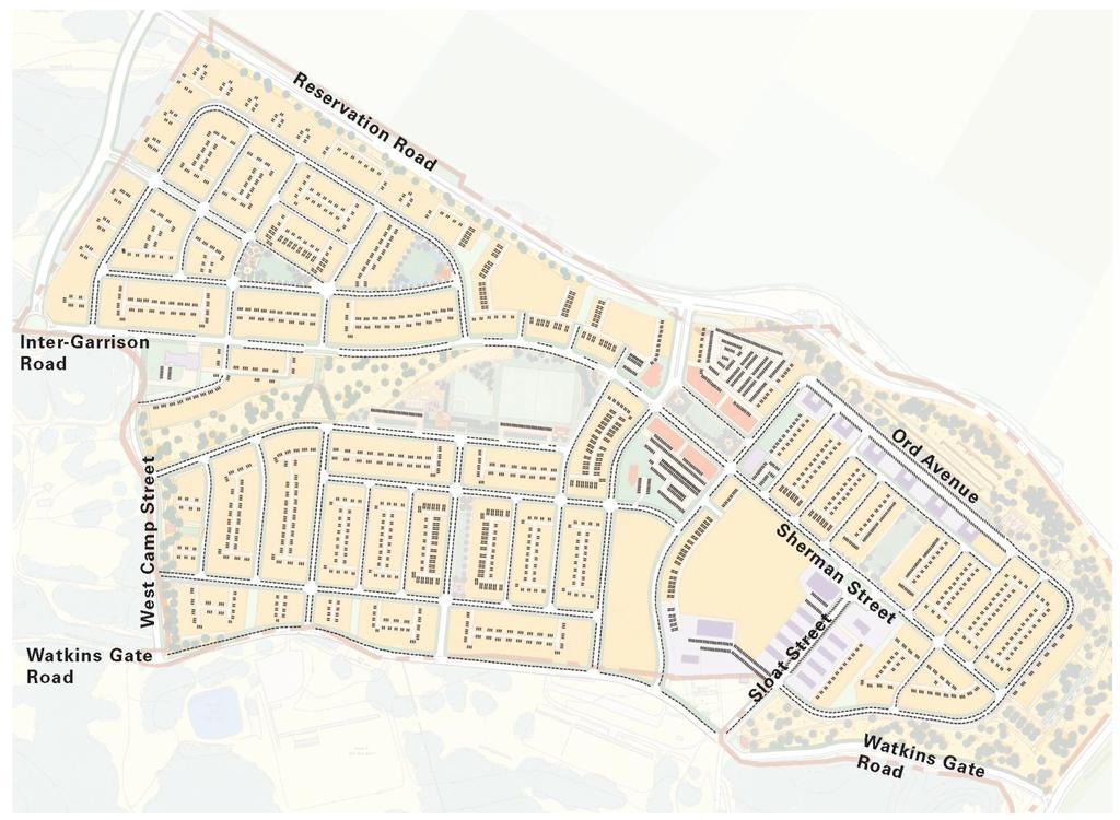
14 Project Description East Garrison Specific Plan - Draft Subsequent EIR Center area will begin during this time, and although development of Town Center buildings will occur throughout all phases of the EGSP project. Rough grading of both the Phase 1 and Phase 2 areas will occur at the beginning of Phase 1. Phase 3 grading will occur during Phase 2 residential construction. The Phase 2 Neighborhood will be located in an area defined by West Camp Road to the west, Inter- Garrison hill to the north, and Chapel Hill Road to the east. The Phase 2 Neighborhood will include deed-restricted affordable units, single-family detached and attached residential uses, and multifamily residential uses. This phase will include construction of neighborhood parks, additional development in the Community Park, greenways, and open space areas. Town Center construction will also occur during this phase. Affordable housing will be constructed in all three project phases. The Phase 3 Arts District will be constructed in the eastern portion of the EGSP site. The Phase 3 Arts District will include deed-restricted affordable residences, single-family detached and attached residential uses, multi-family uses, artist uses, live/work lofts, public uses, open space areas, and bike paths. Proposed housing types are shown in Table 3-1. A more detailed description of project phasing is shown in Table 3-2. Dwelling Size (SF) Table 3-1: Proposed Housing Types Approximate Percentage Number of Dwelling Units Housing Type 1,300 to 3, Single Family Detached 1,300 to 2, Townhomes 500 to 1, Condo/Loft/Apartments 1,100 to 1, Live/Work 450 to 850 n/a 70* Accessory (Carriage House) Total 100% The Option Agreement allows for a maximum of 1470 units. * Water Permitting Source: Urban Design Associates, July Land Use Concept and Project Components The EGSP is a land use plan, including a conceptual site plan and land use designations for the project site. In general, the EGSP project would include a mix of residential, commercial, public, and recreational uses. More specifically, as shown in Exhibit 3-7 and Exhibit 3-8, the EGSP proposes three neighborhoods, including the Arts District and a Town Center; a Bluff Greenway; multi-use paths and open space areas; and a main entrance. The plan will accommodate 1,400 residential units plus up to 70 accessory (carriage house) units, 75,000 sq ft of commercial use, 11,000 sq ft of public use, 100,000 sq ft of artist/cultural/educational space in renovated historic structures, and approximately 50 acres of open space (including approximately 12 acres of improved parks and trails). Other project components include a library, fire station, and a sheriff s field office. The creation, maintenance, and operation of roads, open space (including parks), and other public 3-14 Michael Brandman Associates H:\Client (PN-JN)\2137\ \DSEIR\ _Sec03-00_ProjDesc.doc

15
16

17
18

19
20
21
22
23 East Garrison Specific Plan - Draft Subsequent EIR Project Description amenities associated with the EGSP will be financed through a combination of Community Services District (CSD) and Homeowners Association (HOA) fees and assessments. A more detailed definition of the project components is discussed below. Table 3-2: Proposed Land Uses and Project Phasing Land Use Phase 1 Phase 2 Phase 3 Town Center Total Percentage Residential Medium Residential High Residential High Cultural Town Center Live/Work Public Use >0.5 Open Space Parks Natural Streets Lanes Reservation Road Total % Source: Urban Design Associates, July RESIDENTIAL USES The EGSP includes up to 1,470 residences to be built on 244 gross acres (125 net acres). The housing will be developed at a gross density of approximately 5.7 units per acre, or greater than 11 units per net developed acre. Residential uses would surround the Town Center. In addition, the Town Center would contain up to 40 apartments/condominiums. All neighborhoods will have a grid of pedestrianscale streets. A system of neighborhood parks and open spaces will be integrated into the street grid. Blocks are sized to support a mix of housing types single-family houses, two- and three-story townhouses, carriage houses, apartments, live/work units, and condominiums all designed to meet a wide range of income and family needs. When completed, the neighborhoods will include a spectrum of housing opportunities, including 20 percent dedicated to inclusionary housing, in accordance with the Monterey County Inclusionary Housing Ordinance. Characteristics of the proposed housing types are shown in Table 3.1. Each of the three residential neighborhoods will feature a neighborhood-scale park that will serve as a village green. The community will be constructed using traditional neighborhood design principles, creating a pedestrian-friendly network of streets and parks. Garages, in most cases, will be kept off the street, accessed via rear driving lanes. Building setbacks will range from approximately 0 to 25 feet from the property line. The architecture of all buildings will represent a number of residential styles popular in the region. Michael Brandman Associates 3-23 H:\Client (PN-JN)\2137\ \DSEIR\ _Sec03-00_ProjDesc.doc
24 Project Description East Garrison Specific Plan - Draft Subsequent EIR ARTS DISTRICT The Arts District is characterized by the historic East Garrison concrete buildings. The Arts District will be constructed as part of Phase 3 of the EGSP. Of the 34 existing historic buildings, 23 will be renovated. Adaptive reuse of these buildings will be governed by the Guidelines for Rehabilitating Buildings at the East Garrison, Fort Ord (March 2004) (see Appendix I of this DSEIR). The remaining 11 buildings will be demolished following documentation of the historic features of the buildings. The Battle Simulation Building and the Theater will be rehabilitated, if economically feasible, or may be replaced with new buildings of similar size. In addition to preserving a majority of the concrete buildings, other elements from the 1940s will also be retained and enhanced. These elements include the park at the edge of the bluff, most existing rock walls, one wood building (the Chapel), and WPA sidewalks where possible. As noted above, two other wood buildings, the Theater and Battle Simulation Building, will also be rehabilitated, if economically feasible. Although not considered historic district contributors, these elements complement the design of both the concrete buildings and the new community. An interpretive center documenting the history of the site will be housed in the proposed Library. An interpretive walk marked by sidewalk monuments will link the Library to the historic elements of the site. The existing alignment of Ord Avenue, Sherman Avenue, and Sloat Street will be preserved. These streets are the address for 22 of the 23 historic buildings to be retained. Both Ord Avenue and Sloat Street are very wide by modern standards. Rather than narrowing the pavement, the plan calls for using this cross section for 45 degree angled parking in each direction. A series of one-way streets links Sherman and Ord Avenues, subdividing the former tent area into a system of blocks. The orientation and layout of these blocks and streets is designed to reflect the 1940s layout of this area. Each block will be subdivided into small house sites, similar in scale to the tent sites, further reflecting the former plan. A Pattern Book (architectural and site design guidelines) is included in the EGSP to guide the design of all infill buildings in the Arts District. This document calls for a mix of four vernacular architectural styles: Garrison Craftsman, Picturesque Camp, Mediterranean Revival, and Garrison Revival. These styles were chosen to respect rather than mimic the historic concrete buildings. The adaptive reuse of the three wood buildings will also be governed by this document. TOWN CENTER Approximately 16 acres in the center of the EGSP area would be devoted to a Town Center. The Town Center will be the community s Town Square, a public space serving as the primary gathering place for residents and visitors and acting as a venue for hosting community events, festivals, and concerts. The Town Center will include commercial uses such as shops, art galleries, banking and other services, offices, cafes, restaurants, and public and institutional uses. Some housing will be located in the Town Center, either in apartments or condominiums above retail space, or as live/work units. Proposed uses in the Town Center will vary depending on market conditions, but regionalscale commercial uses (e.g., full-service grocery stores) are not proposed. PUBLIC FACILITIES A number of public facilities are planned to be constructed on the EGSP site, including a fire station, sheriff s substation, library, transit center, community center, post office, or other civic facilities. As proposed by the EGSP, a fire station will be located within the community. Existing schools within the Monterey Peninsula Unified School District (MPUSD) are currently available to serve the project 3-24 Michael Brandman Associates H:\Client (PN-JN)\2137\ \DSEIR\ _Sec03-00_ProjDesc.doc
25 East Garrison Specific Plan - Draft Subsequent EIR Project Description population; however, the County has sufficient land for, and can provide a school site outside of the EGSP project site if required by the MPUSD. 1 PARKS AND OPEN SPACE Implementation of the EGSP would include acres of parkland, which will include walking paths, playing fields, play areas, court games, and community gathering spaces. This system of parks, in addition to open space and habitat preserve, will provide the community with both active and passive recreational opportunities. The EGSP includes provision for the revitalization of an abandoned military park at the bluff edge of the Arts District. The Bluff Greenway will be a linear greenway linking the Town Center to the adjacent neighborhoods and open space network, and will provide views of the Salinas Valley. A multi-use path will be integrated into the greenway, connecting directly to the trail and bike network. Natural slopes will be preserved along the edge of the site and in other areas of grade transition between neighborhoods. To the extent practicable, invasive plant species in these areas will be replaced with native plant materials. Pathways will also be integrated into slope park areas wherever practical Land Use Designations As shown on Exhibit 3-9, the EGSP would include land use designations governing the plan area. These land use designations are described below. RESIDENTIAL MEDIUM (RM) RESIDENTIAL HIGH (RH-1 AND RH-2) The Residential Medium (RM) designation allows single-family detached and attached units, consisting of one- and two-story houses and two- and three-story townhouses. Density will range from 5 to 29 dwelling units per acre (du/acre). Approximately 80 acres (net) will be designated as RM in the EGSP planning area. Dwelling units will be organized into blocks with off-street parking areas served by a system of lanes. The Residential High 1 (RH-1) designation allows single- and multifamily attached housing, consisting of townhouses and apartments. Approximately 130 units of RH-1 housing will be provided on 7.4 acres in the Phase 1 and Phase 2 Neighborhoods. Density will range from 14 to 32 du/acre. Approximately 150 units of Residential High 2 (RH-2) units will be provided in the Phase 3 Arts District. Density will range from 18 to 36 du/acre. Housing will consist of multi-family attached units, including townhouses, apartments, and condominiums. 1 Personal communication, Collette McLaughlin, Facilities Planner, MPUSD, October 16, Michael Brandman Associates 3-25 H:\Client (PN-JN)\2137\ \DSEIR\ _Sec03-00_ProjDesc.doc
26 Project Description TOWN CENTER (TC) LIVE/WORK (LW) CULTURAL (CL) PUBLIC USE (PU) PARKS (P) AND OPEN SPACE (OS) East Garrison Specific Plan - Draft Subsequent EIR The Town Center (TC) designation will allow mixed uses including commercial, public, institutional, and housing. Commercial uses permitted include shops, art galleries, services, banking, professional offices, cafes, and restaurants. Public and institutional uses include a sheriff s field office, library, post office, transit stops, and administrative offices. The TC designation allows for apartments and condominiums. The Live/Work (LW) designation allows residential space above ground floor non-residential uses. Ground floor non-residential uses could include artist studio space, compact offices, and retail space. The LW designation will be permitted in the Town Center area and Arts District. Approximately 49 live/work units and 65 inclusionary live/work units will be accommodated in the Town Center and Arts District, respectively. The Cultural (CL) land use designation would allow studio space for visual, performing, and literary artists, as well as administrative, work, community centers, museums, and classroom uses. All CL land uses will be restricted to approximately 9 acres in the Arts District, where currently vacant buildings will be converted into studio space. The Public Use (PU) designation would allow public facilities such as police and fire stations, government offices, and pump stations. Childcare and educational facilities would be allowed with a use permit approved by the Planning Commission. The new Salinas Rural Fire District Fire Station constructed at the intersection of Inter-Garrison and West Camp Roads and an existing sewage pump facility would be designated as PU. The Parks (P) designation would be reserved for developed park areas and public recreation facilities, including athletic fields and courts, active recreation areas, playgrounds, farmers markets, and gardens. Concession stands would be allowed with a use permit approved by the Planning Commission. The Open Space (OS) designation would allow active recreation and playgrounds (but no athletic fields) and natural resource protection areas. GENERAL PLAN AMENDMENTS In addition to changes in land use designations, the project proposes two General Plan Amendments. As required by state law, the specific plan must be consistent with the MCGP. The following amendments are proposed to the MCGP: Proposed Amendment: In order to preserve the County s scenic and rural character, ridgeline development shall not be allowed unless a special permit is first obtained. Such permit shall only be granted upon findings being made that the development as conditioned by permit will not create a substantially adverse visual impact when viewed from a common public viewing area. New subdivisions shall avoid lot configurations which create building sites that will constitute ridgeline development. Siting of new development visible from 3-26 Michael Brandman Associates H:\Client (PN-JN)\2137\ \DSEIR\ _Sec03-00_ProjDesc.doc

27
28
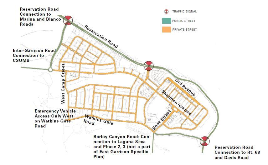
29 East Garrison Specific Plan - Draft Subsequent EIR Project Description private viewing areas, may be taken into consideration during the subdivision process. This policy shall not apply in areas governed by Specific Plans. Each Specific Plan shall address viewshed issues as part of the plan s regulations. Proposed Amendment: Commercial Land Use Policy A-1: The County of Monterey shall allocate land uses and commercial and office categories adequate to provide goods and services for the needs of its citizens, other Fort Ord jurisdictions and their trade areas. In the absence of a Specific Plan, Commercial Land Uses shall be designated not to exceed the following: as follows. Business Park/Light Industrial East Garrison District (Polygon 11b): 70 acres, 0.2 FAR, 609,840 feet 2 Office/R&D: East Garrison District (Polygon 11b): 25 acres, 0.20 FAR, 217,800 feet 2 Convenience/Specialty Retail: Site Circulation and Parking East Garrison District (polygon 11b:) 5 acres, 54,461 sq. ft. 75,000 square feet of specialty retail and 100,000 square feet of artists studio space. The groundfloor of live/work units can also be utilized for commercial use. Square footage limitations shall not apply in areas governed by Specific Plans, so long as the Specific Plan sets forth an alternative allocation of commercial land uses, including office, research/r&d and Convenience/Specialty which total square footage does not exceed the aggregate of commercial square footage set forth above. Such alternative allocations may include hybrids of commercial land uses and residential uses, including but not limited to, Live Work, Town Center, Artists studios, or Mixed Use designations. VEHICLE ACCESS AND PUBLIC TRANSPORTATION A new main entrance would be located just west of the existing East Garrison Gate, leading to the Town Center. Access will also be provided from Reservation Road by reopening the Watkins Gate Road and realigning the upper portion of the roadway. This road will provide access from the Salinas Valley to the project site as well as serve as an access for events at Laguna Seca via Barloy Canyon Road (currently served via the old East Garrison Gate). A portion of Watkins Gate Road will be located outside of the project boundary and will require public easements. Inter-Garrison Road will also provide access to other areas of Fort Ord. A new road will connect Inter-Garrison Road along the western project edge to Reservation Road, as depicted in the Reuse Plan and analyzed in the Fort Ord Reuse Authority Reuse Plan FEIR (June 1997) (FORA FEIR). This road will be located within approximately 7.5 acres of land, outside the project boundary. Traffic signals are proposed at the Michael Brandman Associates 3-29 H:\Client (PN-JN)\2137\ \DSEIR\ _Sec03-00_ProjDesc.doc
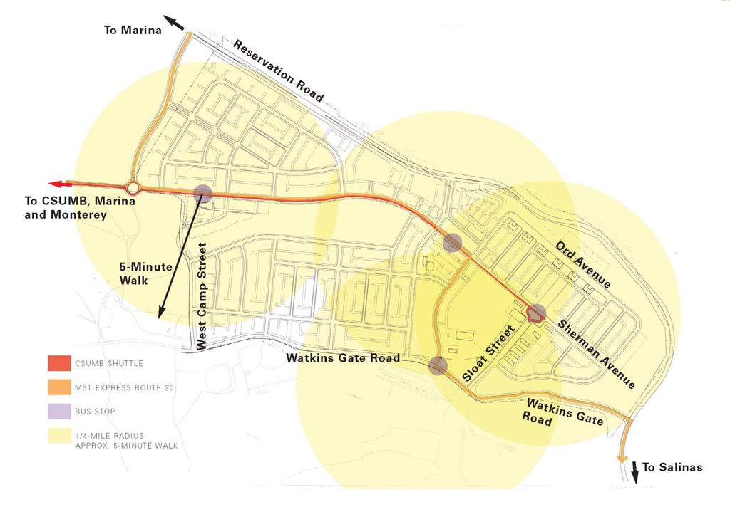
30 Project Description East Garrison Specific Plan - Draft Subsequent EIR intersections of the main entrance and Reservation Road, Inter-Garrison Road (new roadway) and Reservation Road, and Watkins Gate and Reservation Road (see Exhibit 3-10). As shown on Exhibit 3-10, most of the roads on the project site will be maintained and governed by a CSD and/or an HOA. The only proposed public roads are those located around the periphery of the project: a new Inter-Garrison Road connection to Reservation Road, West Camp Street Watkins Gate Road between West Camp Road and Reservation Road will be governed by the County. PUBLIC TRANSPORTATION PLAN The EGSP area will be served by Monterey-Salinas Transit (see Exhibit 3-11). Existing Monterey- Salinas Transit bus routes will be rerouted through the community. All residences will be located within a quarter-mile of a bus stop. In addition to Monterey-Salinas Transit service, a CSUMB shuttle service is proposed between the project site and the campus. From the Arts District, the shuttle will return to CSUMB. As shown on Exhibit 3-10, the shuttle route will be along Inter- Garrison Road and the new East Garrison Road to the Town Center and the Arts District. A pedestrian Circulation Plan is designed to accommodate the needs of pedestrians and bicyclists (see Exhibit 3-12). East Garrison would have a diverse and well-developed pedestrian circulation network. All streets in the community will have sidewalks on at least one side; most will have sidewalks on both sides. The network of sidewalks and paths will connect the three neighborhoods to each other and to the Town Center. Paths and trails along the top of the bluff and throughout the open spaces will extend the pedestrian system through the natural areas and parks. Traffic calming methods will be used where pedestrians might conflict with automobiles. For example, at locations where local streets terminate at a park, a modified T-intersection will be used to slow traffic and to accommodate pedestrian access between the neighborhood and the park. The Pedestrian Circulation Plan will implement the regional trail system as proposed in the Reuse Plan. The planned regional hiking trail will extend through the community along sidewalks and walking paths assuring continuity of the Inter-Garrison Trail and the Salinas Valley Trail. BICYCLE CIRCULATION PLAN The FFO and United States Bureau of Land Management (BLM) lands are well-used by bicyclists of all types and abilities. The new EGSP community would provide amenities in the Town Center such that it becomes a destination for bicyclists accessing the hundreds of miles of existing trails throughout FFO. The Town Center will have bike racks and parking for recreational cyclists will be provided as part of the joint-use Town Center parking reservoir. A minimum of two kiosks illustrating the local and regional bike path network will be provided in the Town Center. East Garrison will facilitate the commuter and recreational cycling routes as planned for in the Reuse Plan (see Exhibit 3-13). Class 2 bikeways along Inter-Garrison Road will extend through the community (on West Camp Road and Watkins Gate Road). These facilities will accommodate commuters and visitors destined for the Town Center and recreational bicyclists destined for the Fort Ord trail system. Bike facilities within the community will connect to roadways and bike facilities at Inter-Garrison Road, Watkins Gate Road, Barloy Canyon Road, and Reservation Road Michael Brandman Associates H:\Client (PN-JN)\2137\ \DSEIR\ _Sec03-00_ProjDesc.doc
31
32
33
34

35
36
37
38
39 East Garrison Specific Plan - Draft Subsequent EIR Project Description PARKING NETWORK The EGSP calls for parking spaces to be located on-street, in designated lots, and on private properties accessed via rear lanes (see Exhibit 3-14). Residential parking will be off-street, accessed by way of the proposed rear lane network. A minimum of two off-street parking spaces per house is required, but many homes will be designed to accommodate three to four cars on-site by using tandem parking or multi-car garages, in conjunction with parking pads or courts. Locating residential parking behind houses creates the opportunity to build streets accommodating parking on both sides. Neighborhood parks are typically served by on-street parking, and the Community Park has two designed off-street lots. The Town Center will be served by a series of designated lots and on-street parking. The 100,000 sq ft of cultural land uses will be served by a combination of parking adjacent to historic buildings, designated lots, and on-street parking while large events may require shuttle service from remote lots on the base, similar to the strategy used for other regional events Utilities Existing water, wastewater, and storm drain facilities on the site were constructed and operated to serve the former military installation. All existing infrastructure within the EGSP area, with the exception of a new sanitary pump station at the main gate, will be replaced. The new community will be served by water, sewer, and power lines that currently extend to the edge of the site, primarily along Inter-Garrison Road. The Marina Coast Water District (MCWD) owns and maintains the water/sewer system. The County has reserved up to 470-acre-feet per year of potable water to serve the project pending processing and environmental review of East Garrison Partners application. The Board of Supervisors will be required to allocate water to the EGSP project as part of the contemplated project approvals. The MCWD requires that East Garrison Partners I, LLC enters into a Construction and Transfer of Water, Sewer, and Recycled Water Infrastructure Agreement, which outlines additional terms and conditions including benefit assessment fees for the project. WATER SYSTEM Existing water distribution system facilities within the project footprint include two above ground 200,000-gallon water storage tanks, two booster pump stations, 12-inch water mains, 6- to 8- inch distribution pipelines, water service connections, and related appurtenances. All of these existing facilities will be removed and disposed of in an approved offsite location and replaced with a new water distribution system that will include 12- to 16-inch diameter main distribution pipelines and appurtenances. An additional 4-million gallon reservoir and its booster station are planned to be constructed by Marina Coast Water District (MCWD) adjacent to the existing off-site reservoir. According to MCWD s recently adopted Water Supply Master Plan, Capital Improvement Program (June 2004), this reservoir is required to meet water storage requirements in Year 2004 (refer to Table 7-1, Water Supply Master Plan). A portion of the new reservoir capacity is estimated for use to meet the commercial fire flow and fire suppression requirements of the EGSP project with the remaining storage capacity used to accommodate water storage requirements of future development on the remaining portion of the Ord Community (as addressed in the Reuse Plan). The volume required to accommodate the water storage requirements of the EGSP project has been estimated to be Michael Brandman Associates 3-39 H:\Client (PN-JN)\2137\ \DSEIR\ _Sec03-00_ProjDesc.doc
40 Project Description East Garrison Specific Plan - Draft Subsequent EIR approximately 20 percent of the total storage volume planned for construction pursuant to the description of the planned development. In addition, the MCWD plans to construct a large water transmission line as part of any roadway construction project from Reservation Road to and along West Camp Street to Watkins Gate. This pipeline would serve planned development identified in the Reuse Plan and analyzed in the Reuse Plan FEIR. POTABLE WATER AUGMENTATION There are no existing potable water augmentation facilities at the project site. Future construction of those facilities will be determined based on the conclusions of MCWD s Regional Urban Water Augmentation Project. The water supply for FFO and MCWD will be augmented through either the use of recycled water or a seawater desalination plant, or a combination of the two. These projects are not part of the EGSP. New recycled water distribution pipelines and appurtenances may be constructed within the Inter-Garrison Road right-of-way (ROW). Uses of recycled water, if required by the MCWD, will be limited to non-potable use for irrigation of landscapes, medians, parks, and playgrounds. WASTEWATER COLLECTION SYSTEM Existing facilities include a non-operating wastewater treatment plant, a pump station, a collection system and related appurtenances. All of these facilities will be removed and replaced with a new wastewater collection system that will include 8- to 12-inch diameter gravity mains that will collect wastewater flows and convey them to the existing pump station. The existing pump station improvements are required to provide additional capacity to service the buildout wastewater flows from the project. An emergency generator will be required for the lift station. The pump station will direct wastewater flows from the project into an existing force main (recently installed) and gravity sewer system along Reservation Road to the Monterey Regional Water Pollution Control Agency s interceptor. The project will require the construction of a parallel main. Pump station improvements and other wastewater collection system improvements from the project site to the interceptor will need to be addressed as determined by the MCWD and prior to each phase of the EGSP project. Construction of needed improvements will be completed by the East Garrison developers. STORM DRAIN SYSTEM Monterey County policy requires that the 100-year post-development storm water flows do not exceed the 10-year predevelopment storm water flows. The EGSP project will include three storm water detention/percolation basins to reduce peak flows to meet these requirements. The reduced storm water flows will leave the site through two existing storm drainpipes under Reservation Road and into the adjacent properties where drainage from the site has historically been conveyed Land Clearing Activities The project site will be graded to create building pads. The proposed grading will balance within the project site and require the movement of approximately 1,400,000 cubic yards of soil. Although the project will be developed in three neighborhood phases, all of the grading for Phases 1 and 2 will occur as part of the first phase. The third phase will require substantially less grading and will occur during Phase 2 residential construction. The density proposed for the community, as well as the grading required to create such a dense community, requires the removal of significant amounts of vegetation. Fifty-three (53) acres of oak 3-40 Michael Brandman Associates H:\Client (PN-JN)\2137\ \DSEIR\ _Sec03-00_ProjDesc.doc
41
42
43 East Garrison Specific Plan - Draft Subsequent EIR Project Description woodland and 38 acres of oak savannah will be removed, predominantly in the western neighborhoods. Other vegetation communities removed include grassland, coastal scrub, and ruderal/disturbed communities. However, the project would result in the preservation of 249 acres of oak woodland, 196 acres of maritime chaparral, and 18 acres of grassland previously slated for development under the HMP Historic Preservation A programmatic agreement exists between the Department of the Army Advisory Council on Historic Preservation and the California State Historic Preservation Officer regarding existing areas and buildings in East Garrison. The Army has agreed to attach covenants to the deed of those East Garrison buildings that have been determined to be contributors to the National Register Historic District. The agreed upon covenant dictates that buildings be maintained in accordance with the guidelines of The Secretary of the Interior s Standards for Rehabilitation Guidelines for Rehabilitating Historic Structures. All construction in the Historic District will comply with the Guidelines for Rehabilitating Buildings at the East Garrison. Of the 34 buildings determined to be contributors to the National Register Historic District, 23 will be retained and 11 will be removed. In addition, a family cemetery and some non-historic structures (a Chapel, and possibly the Battle Simulation Building and Theater) will be preserved. 3.3 PROJECT OBJECTIVES The original vision of East Garrison and the project site is derived from the goals and objectives of Reuse Plan (June 1997), MCGP (1982 as amended in 2001), and the Redevelopment Plan (2002) for East Garrison. Additionally, the Department of Defense is under a legislative mandate to implement base reuse goals and objectives, which are included in the project objectives, and which have been stated in the Army FEIS and FORA FEIR. The objectives of the EGSP build upon those goals and objectives, in addition to drawing on those goals stated by stakeholders during the planning process. The overall objectives of the EGSP project are as follows: Consistent with the Reuse Plan and its FEIR, the project would provide for the reuse and development of the base area in ways that enhance the economy and quality of life of the Monterey Bay community. Consistent with the Army FEIS, the project would provide for the transition of the FFO to civilian use. Give high priority to local economic redevelopment during reuse of Fort Ord. Create a public/private partnership that is financially feasible and fiscally responsible; one in which the Redevelopment Agency as the land seller, receives part of its compensation as a percentage of the net profits. Ensure new development pays for 100 percent of infrastructure and services needed to support the new community. Establish mechanisms for maintaining and operating private infrastructure. Design efficient infrastructure systems that avoid or minimize impacts on the environment. Michael Brandman Associates 3-43 H:\Client (PN-JN)\2137\ \DSEIR\ _Sec03-00_ProjDesc.doc
44 Project Description East Garrison Specific Plan - Draft Subsequent EIR Assist the Redevelopment Agency in obtaining the available property to implement its redevelopment plan. Allow the creation of much needed housing in the community. Create a mixed-income community with a broad range of housing opportunities that are affordable by design. Target development areas where impacts on the environment will be avoided or minimized. Create a compact, efficient community with a minimal footprint. Integrate the surrounding native habitats into the open spaces within the community. Create buffers around the community that help transition from a native habitat/ecosystem to an urban habitat/ecosystem. Encourage multi-modal transportation opportunities, especially bicycle, pedestrian, and transit by providing a compact mix of uses, small blocks, interconnected streets, sidewalks, and traffic calming measures, such as traffic circles and buildout. Reduce groundwater consumption with water reclamation programs, drought-tolerant landscaping, and groundwater recharge efforts. Support all provisions of the Installation-Wide Multispecies Habitat Management Plan for Former Fort Ord (April 1997) as amended. Collaborate with Monterey-Salinas Transit (MST) and CSUMB to assure the entire community is well served with transit. Minimize the amount of impervious surfaces by minimizing the widths of streets. Create a diverse mixed-income community with a full spectrum of life-cycle housing opportunities. Celebrate the history of the site by reusing existing buildings and structures where feasible. Create a destination for artists that imbues the entire community with creative spirit. 3.4 INTENDED USES OF THIS DSEIR This DSEIR is being prepared by the County of Monterey to assess the potential environmental impacts that may arise in connection with actions related to implementation of the EGSP. Pursuant to of the California Environmental Quality Act (CEQA), the County of Monterey is the lead agency for the proposed project and has discretionary authority over the EGSP and project approvals. It is the County s intent to rely on this DSEIR in determining whether to approve the EGSP and all infrastructure and development improvements contained in the EGSP and whether to take associated discretionary actions related to implementation of the EGSP Michael Brandman Associates H:\Client (PN-JN)\2137\ \DSEIR\ _Sec03-00_ProjDesc.doc
FORT ORD MASTER PLAN GREATER MONTEREY PENINSULA AREA PLAN
 FORT ORD MASTER PLAN GREATER MONTEREY PENINSULA AREA PLAN DESCRIPTION The purpose of this plan is to designate land uses and incorporate objectives, programs, and policies to be consistent with the Fort
Gold Line Bus Rapid Transit Transit Oriented Development (BRTOD) Helmo Station Area Plan
 Helmo Station Area Plan") Appendix F Gold Line Bus Rapid Transit Transit Oriented Development (BRTOD) Helmo Station Area Plan Introduction and Purpose of the Plan The Gold Line Bus Rapid Transit facility is an eleven-mile dedicated
Appendix F Gold Line Bus Rapid Transit Transit Oriented Development (BRTOD) Helmo Station Area Plan Introduction and Purpose of the Plan The Gold Line Bus Rapid Transit facility is an eleven-mile dedicated
Ten Mile Creek Planning Area
 PLANNING AREA POLICIES TEN MILE CREEK Ten Mile Creek Planning Area Location and Context The Ten Mile Creek Planning Area ( Ten Mile Creek area ) is located south of the current Boise AOCI, generally south
Department of Community Development. Planning and Environmental Review Division Revised Notice of Preparation
 Department of Community Development Michael J. Penrose, Acting Director Divisions Building Permits & Inspection Code Enforcement County Engineering Economic Development & Marketing Planning & Environmental
Fort Ord Regional Trails Planning
 Fort Ord Regional Trails Planning FORA Board July 11, 2014 Josh Metz, Associate Planner Overview Base Reuse Plan (BRP) trails planning context Trails planning in FORA jurisdictions and related entities
Venice Pumping Plant Dual Force Main Project Draft EIR
 City of Los Angeles 5.9 LAND USE PLANS 5.9.1 Environmental Setting Venice Pumping Plant Dual Force Main Project Draft EIR The Project lies within the bounds of Los Angeles County and the City of Los Angeles.
East Garrison Pattern Book. Urban Design Associates
 East Garrison Pattern Book Urban Design Associates july 2004 Design Guidelines for a New Community Master Developer east garrison partners 1, llc Master Code Consultant urban design associates Pittsburgh,
CITY OF SEASIDE STAFF REPORT
 Item 12 CITY OF SEASIDE STAFF REPORT TO: FROM: BY: Honorable Mayor and City Council Ray Corpuz, City Manager Diana Ingersoll, Deputy City Manager, Resource Management Services Rick Medina, Senior Planner
LAND USE ELEMENT. Purpose. General Goals & Policies
 LAND USE ELEMENT Purpose This Land Use Element contains the goals and policies necessary to support the City s responsibility for managing land resources and guiding development through implementing regulations,
The Vision. Photo provided by The Minervini Group. 46 Vision, Objectives & Strategies
 Vision, Objectives & Strategies The is the public framework and guide for future development of the Grand Traverse Commons. The establishes public polices for infrastructure, the preservation of natural
EXISTING COMPREHENSIVE PLAN
 EXISTING COMPREHENSIVE PLAN Town Center Land Use Element: V. LAND USE POLICIES Town Center Mercer Island's business district vision as described in "Your Mercer Island Citizen-Designed Downtown" was an
3.1 community vision. 3.3 required plan elements
 Chapter 3 Community Form 3.1 community vision 3.2 Parks & landscaping concepts 3.3 required plan elements D R A F T 20 Community Form Chapter 3 3.0 Community form 3.1 community vision The Specific Plan
Design Fort Ord. welcome why we are here what happened this week design guidelines: ideas so far 2/12/2015. Regional Urban Design Guidelines (RUDG)
") Design Fort Ord Regional Urban Design Guidelines (RUDG) Welcome Back! Strategic Economics Alta Planning + Design National Charrette Institute Helix Environmental Planning Jeff Speck & Peter Katz Civitas
Design Fort Ord Regional Urban Design Guidelines (RUDG) Welcome Back! Strategic Economics Alta Planning + Design National Charrette Institute Helix Environmental Planning Jeff Speck & Peter Katz Civitas
Dwelling Units Max 12 dwelling units per acre/min 8 dwelling units per acre. Development Mix 80% non residential/20% residential
 13. OSTEEN LOCAL PLAN Background: The Osteen Local Plan area is located in southwest Volusia County along the SR 415 corridor between Lemon Bluff Road and Acorn Lake Road and includes 3,990 acres. The
COLVER ROAD INDUSTRIAL CONCEPT PLAN
 COLVER ROAD INDUSTRIAL CONCEPT PLAN A CONCEPTUAL LAND USE AND TRANSPORTATION PLAN FOR TA-4 AN URBAN RESERVE AREA OF THE CITY TALENT City of Talent Adopted by City Council Resolution No., June, 2015 PART
Planning Districts INTRODUCTION
 INTRODUCTION To facilitate detailed examination of development prospects for all areas of the community, Delano has been divided into 14 planning districts. The location of these planning districts is
Joint Study Session of the Sutter County. March 2, 2009
 Joint Study Session of the Sutter County Board of Supervisors and Planning Commission March 2, 2009 CURRENT APPLICATION General Plan Amendment Specific Plan Specific Plan Appendices Utility Plans Transit/AQ
Fort Ord Reuse Plan Attachment E to Item 7e FORA Board Meeting, 3/9/ Permitted Range of Land Uses for Fort Ord 226
 City of Seaside: In September 1991, the city submitted two separate requests to amend its SOI, with the goal of defining its Fort Ord SOI for general planning purposes. The proposed Seaside SOI boundaries
Mitchell Ranch South MPUD Application for Master Planned Unit Development Approval Project Narrative. Introduction
 Mitchell Ranch South MPUD Application for Master Planned Unit Development Approval Project Narrative Introduction Mitchell Ranch South is a proposed single family (detached) residential development on
3.10 LAND USE SETTING PROJECT SITE EXISTING LAND USE DESIGNATIONS AND ZONING. General Plan Land Use Designations.
 This section of the Draft EIR addresses the existing land uses on and adjacent to the project site and discusses the potential impacts of the proposed project on existing land uses. Key issues addressed
2 Project Description
 Project Description 2 Project Description The proposed project would involve the demolition of the existing church and the construction of 40 twostory single family residences. The residential lots would
The transportation system in a community is an
 7 TRANSPORTATION The transportation system in a community is an important factor contributing to the quality of life of the residents. Without a sound transportation system to bring both goods and patrons
INTRODUCTION. 1.1 What is a General Plan? 1.2 Requirements for a General Plan. 1.3 Introduction to Monterey County
 1.1 What is a General Plan? INTRODUCTION California state law requires each city and county to adopt a comprehensive, long-term general plan for the physical development of the county or city, and any
PORT WHITBY COMMUNITY
 PORT WHITBY COMMUNITY SECONDARY PLAN UPDATE COMMUNITY IMPROVEMENT PLAN URBAN DESIGN GUIDELINES September 2015 DRAFT PROPOSED AMENDMENT NUMBER # to the Whitby Official Plan PURPOSE: The intent of this Amendment
Town of Portola Valley General Plan. Nathhorst Triangle Area Plan
 Town of Portola Valley General Plan Amended December 10, 1997 Table of Contents Introduction... 1 Planning Area... 1 Objectives... 2 Principles... 2 Standards... 4 Description... 4 Community Commercial...
Transportation. Strategies for Action
 Transportation A major priority for the Overlake Neighborhood is to develop a multimodal transportation system. To achieve this system, a balance has to be found among travel, circulation and access needs;
Asbury Chapel Subdivision Sketch Plan
 Asbury Chapel Subdivision Sketch Plan PART 1: PROJECT SUMMARY Applicant: NVR Inc. Project Size: +/- 76.13 acres Parcel Numbers: 02101112,02116101,02116112, 02116113 Current Zoning: Transitional Residential
ARTICLE 6: Special and Planned Development Districts
 ARTICLE 6: Special and Planned Development Districts 6-10 Traditional Neighborhood Development (TND) District 6-10.10 Purpose and Intent The Traditional Neighborhood Development (TND) District provides
FUTURE LAND USE ELEMENT
 FUTURE LAND USE ELEMENT GOAL I: To create and sustain a great place to live, play, and prosper Objective 1: The City of Ocala shall incorporate the principles and strategies of the Ocala 2035 Vision into
Secrest Short Cut and Monroe Expressway Small Area Plan AUGUST 29, 2018
 Secrest Short Cut and Monroe Expressway Small Area Plan AUGUST 29, 2018 Background and Process Monroe Expressway will be open by the end of 2018 Union County and Indian Trail identified a need to revisit
General Location Annex, Rezone & Preliminary Plat Lansdowne Addition, Unit Three
 NEWFOUNDLAND I-5 Agricultural District Subject Site SUNDANCE ANDERSON Single Family Residential CHRISTY PUD Agricultural District Highway Business General Location Annex, Rezone & Preliminary Plat Lansdowne
Town Center. Block 5 Existing multifamily residential units are expected to remain.
 Area Guidelines Germantown s districts should be developed as distinct communities with unique features that are supported through the guidelines. The guidelines not only help distinguish these districts
Appendix I-A3 DENAIR COMMUNITY PLAN
 Appendix I-A3 DENAIR COMMUNITY PLAN Adopted by the Stanislaus County Board of Supervisors DECEMBER 15, 1998* *A technical update removing reference to the former Stanislaus County Redevelopment Agency
Glenborough at Easton Land Use Master Plan
 Implementation 114 9.0 IMPLEMENTATION 9.1 OVERVIEW This chapter summarizes the administrative procedures necessary to implement the proposed land use plan, infrastructure improvements, development standards,
CHAPTER 22 Rural Open Space Community Developments
 CHAPTER 22 Rural Open Space Community Developments Section 22.1 Description and Purpose The intent of this Chapter is to offer property owners an alternative to traditional zoning requirements for rural
PLAN ELEMENTS WORKSHOP. April 5, 2016
 PLAN ELEMENTS WORKSHOP April 5, 2016 needs more housing. But there is no one-size fits-all solution. Every neighborhood has its own character. In some places, density is not only appropriate it is badly
BROOKHILL NEIGHBORHOOD MODEL ZONING MAP AMENDMENT PREFACE TO APPLICATION
 BROOKHILL NEIGHBORHOOD MODEL ZONING MAP AMENDMENT PREFACE TO APPLICATION June 15, 2015 Revised: August 1, 2016 I. VISION Brookhill is a proposed community based upon the principles of Albemarle County
PLANNING COMMISSION. Submitted
 PLANNING COMMISSION City Hall 1275 Main Street El Centro, CA 92243 Submitted PLANNING COMMISSION ACTION ITEM (1844) Meeting: 05/10/16 12:00 AM Department: Community Development Category: Public Hearing
Neighborhood Districts
 NEIGHBORHOOD DISTRICTS SEVEN MAIN DISTRICTS Neighborhood Districts While the Development Plan provides a broad-scale overview of the neighborhood, this section focuses on uses and relationships at the
2025 COMPREHENSIVE PLAN PASCO COUNTY, FLORIDA
 GOAL FLU 6: PASADENA HILLS FUTURE LAND USE: PASADENA HILLS AREA PLAN GOALS, OBJECTIVES, AND POLICIES PASADENA HILLS AREA PLAN: OVERVIEW The Pasadena Hills Area Plan Goals, Objectives, and Policies are
Description of Preferred Alternative
 Chapter 2 Description of Preferred Alternative 2.1 Introduction This chapter of the programmatic Sammamish Town Center Sub-area Plan Final EIS provides a more detailed description of the Preferred Alternative
Land Use Amendment in Southwood (Ward 11) at and Elbow Drive SW, LOC
 at and Elbow Drive SW, LOC") 2018 November 15 Page 1 of 10 EXECUTIVE SUMMARY This land use amendment application was submitted by Rick Balbi Architect on 2017 August 31 on behalf of Sable Developments Ltd, and with authorization from
2018 November 15 Page 1 of 10 EXECUTIVE SUMMARY This land use amendment application was submitted by Rick Balbi Architect on 2017 August 31 on behalf of Sable Developments Ltd, and with authorization from
CONTENTS 8.0 LAND USE 8.1 GENERAL LAND USE 8.2 RESIDENTIAL 8.3 MIXED USE 8.4 COMMERCIAL 8.5 EMPLOYMENT LANDS
 8-2 Land Use 8.0 LAND USE CONTENTS 8.1 GENERAL LAND USE 8.1.1 Uses provided for in all Land Use Designations 8.1.2 Uses prohibited in Hazardous Lands, Hazardous Sites and Special Policy Areas 8.1.3 Uses
Town Center (part of the Comprehensive Plan)
") Town Center (part of the Comprehensive Plan) Mercer Island Town Center Looking North (2014) In 1994, a year-long process culminated in a set of design guidelines and code requirements for the Town Center
Town Center (part of the Comprehensive Plan) Mercer Island Town Center Looking North (2014) In 1994, a year-long process culminated in a set of design guidelines and code requirements for the Town Center
Olde Towne Vision Plan
 Olde Towne Vision Plan Introduction In 2016, the City of Bellevue will complete its move of City offices from Olde Towne Bellevue to its new municipal complex on Wall Street. The City intends to sell its
PLANNED UNIT DEVELOPMENT Date: April 5, 2018
 PLANNED UNIT DEVELOPMENT Date: April 5, 2018 DEVELOPMENT NAME SUBDIVISION NAME LOCATION Robert Myers Robert Myers 2955 and 2989 Dauphin Street (Southeast corner of Dauphin Street and Sage Avenue) CITY
CHAPTER 1. Ms. Guajardo s Class - Central Elementary CH 1 1
 INTRODUCTION CHAPTER 1 Ms. Guajardo s Class - Central Elementary CH 1 1 1.1 SETTING South Centre City is a linear corridor south of Downtown Escondido paralleling Centre City Parkway and South Escondido
APPENDIX C SPECIAL PLANNING AREAS
 SPECIAL PLANNING AREAS There are five Special Planning Areas (SPAs) on the Land Use Diagram (Figure LU-2). The SPAs are areas with significant new growth potential that require more detailed subsequent
CHAPTER 7: Transportation, Mobility and Circulation
 AGLE AREA COMMUNITY Plan CHAPTER 7 CHAPTER 7: Transportation, Mobility and Circulation Transportation, Mobility and Circulation The purpose of the Transportation, Mobility and Circulation Chapter is to
2.7 ac park. TOTAL 5,403 DU 1,297,900 sf 1,105,450 sf 3.87 ac 5,563 DU 1,121,200 sf 1,105,450 sf 3.87 ac
 PLAN AMENDMENT 2013-I-B1: SEVEN CORNERS SPECIAL STUDY Summary of Pre-staffing Comments Planner: Bernard Suchicital bsuchi@fairfaxcounty.gov (703) 324-1254 Background On October 29, 2013, the Board of Supervisors
CHAPTER 3 VISION, GOALS, & PLANNING PRINCIPLES. City of Greensburg Comprehensive Plan. Introduction. Vision Statement. Growth Management Goals.
 CHAPTER 3 VISION, GOALS, & PLANNING PRINCIPLES Introduction The Greensburg Comprehensive Plan is intended as a working community document. A combination of long and short-term goals, this document is intended
URBAN DESIGN BRIEF. 2136&2148 Trafalgar Road. Town of Oakville
 URBAN DESIGN BRIEF 2136&2148 Trafalgar Road Town of Oakville Prepared By: METROPOLITAN CONSULTING INC For 2500674 Ontario Inc November 2016 TABLE OF CONTENTS Page No. 1.0 Introduction/Description of Subject
Improve Neighborhood Design and Reduce Non Point Source Water Pollution
 HOW TO Planning Guide Improve Neighborhood Design and Reduce Non Point Source Water Pollution This document was funded by a grant from the New Hampshire Coastal Program with funding from the National Oceanic
4.1.3 LAND USE CATEGORIES
 4.1.3 LAND USE CATEGORIES a. City Center District The City Center District incorporates the existing character and mix of uses in downtown Belmont to encourage redevelopment and new development in keeping
Planning Commission Staff Report June 5, 2008
 Owner/Applicant Taylor Village Sacramento Investments Partners, LP c/o Kim Whitney 1792 Tribute Road #270 Sacramento, CA 95815 Staff Recommendation Planning Commission Staff Report Project: File: Request:
North Oakville East Parks Facilities Distribution Plan. November, 2009
 North Oakville East November, 2009 POLICY CONTEXT 1) Purpose a) The purpose of this document is to be a guide for the location, configuration, design and development of the parks system for the North Oakville
3. VISION AND GOALS. Vision Statement. Goals, Objectives and Policies
 Vision Statement Queen Creek s interconnected network of parks, trails, open spaces and recreation opportunities provide safe and diverse activities and programs that sustain its unique, small town, equestrian
SECTION 3: PROJECT DESCRIPTION
 San Ramon City Center - City of San Ramon Draft Subsequent EIR Project Description SECTION 3: PROJECT DESCRIPTION This section describes the proposed San Ramon City Center Project (proposed project) that
4. ENVIRONMENTAL IMPACT ANALYSIS 7. LAND USE AND PLANNING
 4. ENVIRONMENTAL IMPACT ANALYSIS 7. LAND USE AND PLANNING 4.7.1 INTRODUCTION The following analysis discusses the consistency of the Proposed Project with the corresponding land use and zoning designations
2025 COMPREHENSIVE PLAN PASCO COUNTY, FLORIDA
 GOAL FLU 6: PASADENA HILLS FUTURE LAND USE: PASADENA HILLS AREA PLAN GOALS, OBJECTIVES, AND POLICIES PASADENA HILLS AREA PLAN: OVERVIEW The Pasadena Hills Area Plan Goals, Objectives, and Policies are
A. WHAT IS A GENERAL PLAN?
 I. Introduction A. WHAT IS A GENERAL PLAN? A general plan is the planning guideline for the future of a city. It contains goals and policies which regulate urban development, the protection of the natural
Urban Development Areas Bedford County
 5 Urban Development Areas Bedford County UDA Needs Profile: All UDAs Bedford County has designated two UDAs: areas just outside the Bedford City Limits (generally to the south and east of the city) and
PROP. 84 REMOVING BARRIERS TO LID: MUNICIPAL CODE UPDATE ASSISTANCE CASE STUDY: CODE UPDATES IN ARCATA
 PROP. 84 REMOVING BARRIERS TO LID: MUNICIPAL CODE UPDATE ASSISTANCE CASE STUDY: CODE UPDATES IN ARCATA OCTOBER 7, 2015 CASE STUDY: CODE UPDATES IN ARCATA Arcata is a city located in Humboldt County immediately
Mariposa Lakes. Planned Community. Project Overview. Stockton, CA
 Planned Community Stockton, CA Project Overview March 2007 Summary of Proposed Community is a master-planned community proposed for development on approximately 3,810 acres in southeast Stockton. In 2004,
KASPER. City of Georgetown, Texas PUD Planned Unit Development. December 30, 2015 Revised January 27, 2016
 KASPER City of Georgetown, Texas PUD Planned Unit Development December 30, 2015 Revised January 27, 2016 Applicant: Sentinel Land Company, LLC 4910 Campus Drive Newport Beach, CA Prepared by: SEC Planning
McDonald s Restaurant - Purcellville Town of Purcellville Special Use Permit Statement of Justification July 24, 2014
 Introduction / Written Statement McDonald s Restaurant - Purcellville McDonald s Corporation is proposing to redevelop the existing McDonald s eating establishment with a drive-through located at 121 N
ALBEMARLE COUNTY CODE CHAPTER 18 ZONING SECTION 20A NEIGHBORHOOD MODEL - NMD
 CHAPTER 18 ZONING SECTION 20A NEIGHBORHOOD MODEL - NMD Sections: 20A.1 PURPOSE AND INTENT 20A.2 STATUS AS A PLANNED DEVELOPMENT DISTRICT 20A.5 CODES OF DEVELOPMENT 20A.6 PERMITTED USES 20A.7 RESIDENTIAL
CHARLES PUTMAN CHARLES PUTMAN AND ASSOCIATES, INC
 MEMORANDUM CHARLES PUTMAN & ASSOCIATES, INC. LAND DEVELOPMENT CONSULTANTS PLANNING ZONING PERMITTING 4722 NW Boca Raton Boulevard, Suite C-106 Boca Raton, Florida 33431 Phone: 561/994-6411 FAX: 561/994-0447
AWH REPORT OF THE PLANNING AND DEVELOPMENT DEPARTMENT FOR APPLICATION FOR REZONING ORDINANCE TO PLANNED UNIT DEVELOPMENT
 AWH REPORT OF THE PLANNING AND DEVELOPMENT DEPARTMENT FOR APPLICATION FOR REZONING ORDINANCE TO PLANNED UNIT DEVELOPMENT MAY 8, 2014 The Planning and Development Department hereby forwards to the Planning
ROAD CLOSURE AND LAND USE AMENDMENT SILVER SPRINGS (WARD 1) NORTHEAST OF NOSEHILL DRIVE NW AND SILVER SPRINGS ROAD NW BYLAWS 2C2018 AND 29D2018
 NORTHEAST OF NOSEHILL DRIVE NW AND SILVER SPRINGS ROAD NW BYLAWS 2C2018 AND 29D2018") Page 1 of 19 EXECUTIVE SUMMARY This application proposes redesignating two parcels in the community of Silver Springs from Special Purpose Future Urban Development (S-FUD) District and undesignated road
Page 1 of 19 EXECUTIVE SUMMARY This application proposes redesignating two parcels in the community of Silver Springs from Special Purpose Future Urban Development (S-FUD) District and undesignated road
UNIVERSITY OF MICHIGAN:
 Chapter Eight UNIVERSITY OF MICHIGAN: North Campus I. Introduction The University of Michigan currently owns approximately 800 acres of land in the northeast section of Ann Arbor. North Campus refers to
Baumgarten MPUD. Exhibit 3 Evaluation Criteria
 Pursuant to LDC subsections 10.02.13 B, 10.02.08 F and Chapter 3 G. of the Administrative Code, staff s analysis and recommendation to the Planning Commission, and the Planning Commission s recommendation
SPECIFIC PLAN Requirements
 CITY OF LANCASTER PLANNING DEPARTMENT 44933 Fern Avenue, Lancaster, California 93534 (661) 723-6100 SPECIFIC PLAN Requirements Purpose The purpose of a specific plan is to provide for the logical development
SOUTH NATOMAS COMMUNITY PLAN
 SOUTH NATOMAS Community Plan Part Three : COMMUNITY PLAN AREAS AND SPECIAL STUDY AREAS SACRAMENTO 2030 GENERAL PLAN Contents Community Location... 3-SN-3 Community Vision... 3-SN-4 Community Profile...
Planned Development Review Revisions (Project No. PLNPCM )
") Planned Development Review Revisions (Project No. PLNPCM2014-00139) Standard residential development Planned Development Example: Smaller lot sizes than what is allowed to create open space amenity. What
Planned Development Review Revisions (Project No. PLNPCM2014-00139) Standard residential development Planned Development Example: Smaller lot sizes than what is allowed to create open space amenity. What
Outline Plan in Belvedere (Ward 9) at Street SE, LOC (OP)
 at Street SE, LOC (OP)") 2018 October 04 Page 1 of 12 EXECUTIVE SUMMARY This outline plan application was submitted by B&A Planning Group on 2016 July 15, on behalf of Tristar Communities Inc. for 50.14 hectares (123.89 acres)
2018 October 04 Page 1 of 12 EXECUTIVE SUMMARY This outline plan application was submitted by B&A Planning Group on 2016 July 15, on behalf of Tristar Communities Inc. for 50.14 hectares (123.89 acres)
Former Rockcliffe Airbase Community Design Plan Guiding Design Vision and Principles December 4, 2013
 APPENDIX 5 - Guiding Design Vision and Principles Former Rockcliffe Airbase Community Design Plan Guiding Design Vision and Principles December 4, 2013 Vision Statement The redevelopment of the former
TOP TEN LIST OF COMMUNITY CONCERNS REGARDING PROPOSED AMENDMENTS TO CHAPTER 42
 TOP TEN LIST OF COMMUNITY CONCERNS REGARDING PROPOSED AMENDMENTS TO CHAPTER 42 1. Extend the urban area to Beltway 8 in stages, over say a three-year period, prioritizing development in transit and declining
COMMUNITY DESIGN. GOAL: Create livable and attractive communities. Intent
 COMMUNITY DESIGN Intent An attractive, well-designed County will attract quality development, instill civic pride, improve the visual character of the community, and create a strong, positive image for
1.0 Circulation Element
 5/9/18 1.0 Circulation Element 1.1 Introduction As growth and development occur in Apache County, enhancements to its circulation system will be necessary. With time, more roads will be paved and air and
Presentation of the Staff Draft. July 17, 2014 SSRVP Team, Area 3
 Presentation of the Staff Draft July 17, 2014 SSRVP Team, Area 3 Presentation Overview Introduction Plan Framework Plan Recommendations Implementation Next Steps and Request for Public Hearing on September
3. Project Description
 3.1 PROJECT LOCATION The Platinum Triangle (herein after also referred to as the Project Area ) is located at the confluence of the Interstate 5 (I-5 Freeway) and the State Route 57 (SR-57 Freeway), in
2136 & 2148 Trafalgar Road Town of Oakville Region of Halton
 PLANNING JUSTIFICATION REPORT 2136 & 2148 Trafalgar Road Town of Oakville Region of Halton Zoning By-Law Amendment Application 2500674 Ontario Inc. November 2016 Table of Contents Page 1.0 Location/Summary
EXECUTIVE SUMMARY DRAFT CHAPTER 1 INTRODUCTION EXECUTIVE SUMMARY
 CHAPTER 1 EXECUTIVE SUMMARY INTRODUCTION Through the joint efforts of the City of Tulsa planning staff and the Land Services division of Indian Nations Council of Governments (INCOG), the Berryhill Land
Urban Planning and Land Use
 Urban Planning and Land Use 701 North 7 th Street, Room 423 Phone: (913) 573-5750 Kansas City, Kansas 66101 Fax: (913) 573-5796 Email: planninginfo@wycokck.org www.wycokck.org/planning To: From: City Planning
City of Chickasaw Land Use Comprehensive Plan 2030 Chapter5-Draft(2)Public review_
Public review_") Land Use Land Use refers to the activity or development characteristics of a given parcel of land. The Land Use Plan presented in the following pages, represents the City of Chickasaw s official position
Land Use Land Use refers to the activity or development characteristics of a given parcel of land. The Land Use Plan presented in the following pages, represents the City of Chickasaw s official position
6 PORT SYDNEY SETTLEMENT AREA
 Section 6 Port Sydney Page 61 6 PORT SYDNEY SETTLEMENT AREA 6.1 Basis and Principles Village of Port Sydney Waterfront Community Existing Services 6.1.1 Port Sydney is an historic settlement that has developed
City of Hermosa Beach Administrative Policy #
 City of Hermosa Beach Administrative Policy # SUBJECT: Living Streets Policy Date: Approved by: City Council Authority: Public Works Department & Community Development Department Mayor, PURPOSE The City
Civic Center District
 Civic Center District The Civic Center district is the civic and social heart of Warrenville, containing such public buildings as the City Hall, Warrenville Public Library, Police Station, Park District
Executive Summary. NY 7 / NY 2 Corridor
 Executive Summary NY 7 / NY 2 Corridor Transportation and Land Use Study December 2005 Prepared for: Town of Colonie Capital District Transportation Committee Prepared by: Introduction: Land use decisions
PART 1: PROJECT SUMMARY. The application is Attachment A. The site plan is Attachment B.
 Belleterre Subdivision Sketch Plan Town Board 8.7.17 Belleterre Subdivision Sketch Plan PART 1: PROJECT SUMMARY Applicant: Bowman Development Project Size: +/- 20.85 acres Parcel Number: 01115104 and 01115121
K. SMART ASSOCIATES LIMITED
 Planning Justification Report Zoning By-Law Amendment 185 King Street North Waterloo, Ontario April 7th, 2017 Project Reference Number 16-245 K. SMART ASSOCIATES LIMITED CONSULTING ENGINEERS AND PLANNERS
SECTION II SECTION II STATEMENT OF GOALS, OBJECTIVES, PRINCIPLES, ASSUMPTIONS, POLICIES AND STANDARDS
 STATEMENT OF GOALS, OBJECTIVES, PRINCIPLES, ASSUMPTIONS, POLICIES AND STANDARDS 1 2 STATEMENT OF GOALS, OBJECTIVES, PRINCIPLES, ASSUMPTIONS, POLICIES AND STANDARDS INTRODUCTION The New Jersey Municipal
COMMISSION ACTION FORM
 ITEM #: 6 DATE: 09-06-17 COMMISSION ACTION FORM REQUEST: Introduction and Initial Review of Proposed Amendments to the Ames Urban Fringe Future Land Map for the North Growth Gap Area BACKGROUND INFORMATION:
Prepared by: Casey Kempenaar, Senior Planner
 CITY OF CITRUS HEIGHTS PLANNING DIVISION STAFF REPORT PLANNING COMMISSION MEETING September 13, 2017 Prepared by: Casey Kempenaar, Senior Planner REQUEST The applicant requests a Design Review Permit Modification
PUBLIC SERVICES ELEMENT GOALS / POLICIES / MEASURES
 PUBLIC SERVICES ELEMENT GOALS / POLICIES GOALS / POLICIES / MEASURES Authority The Public Services Element addresses provision of municipal services to City residents. The following paragraphs provide
PLANNED UNIT DEVELOPMENT STAFF REPORT Date: June 2, 2016
 # 9 ZON2016-01032 PLANNED UNIT DEVELOPMENT STAFF REPORT Date: June 2, 2016 DEVELOPMENT NAME JJT Properties LLC LOCATION 1147 & 1151 East I-65 Service Road South and 1180 Sledge Drive (Southeast corner
Mill Conversion Overlay District Zoning Bylaw Amendment
 Mill Conversion Overlay District Zoning Bylaw Amendment To see if the Town will vote to amend the Zoning By-Law by adding a new Section 13, Mill Conversion Overlay District, and by amending Sections 2.1,
Table of Contents. Elm Avenue Improvement Plan City of Waco, Texas. Introduction 1. Existing Context 1 Figure 1 2.
 Table of Contents Introduction 1 Existing Context 1 Figure 1 2 Plan Guidelines 3 Future Urban Form 4 The West-End 4 Main Street 6 The East-End 7 Figure 2 9 Public Improvement Recommendations 7 General
SUBJECT: PREDEVELOPMENT PLAN REVIEW OF PROJECT LOCATED AT 2632 EAST WASHINGTON BOULEVARD ('ST. LUKE MEDICAL CENTER')
") TO: FROM: Honorable Mayor and City Council Planning & Community Development Department SUBJECT: PREDEVELOPMENT PLAN REVIEW OF PROJECT LOCATED AT 2632 EAST WASHINGTON BOULEVARD ('ST. LUKE MEDICAL CENTER')
TO: FROM: Honorable Mayor and City Council Planning & Community Development Department SUBJECT: PREDEVELOPMENT PLAN REVIEW OF PROJECT LOCATED AT 2632 EAST WASHINGTON BOULEVARD ('ST. LUKE MEDICAL CENTER')