Gateway Sites. Gateway Index. Legend. 18 Gage Bellerive Dr. City Limits I-182 SR 240. By-Pass Highway. G.W. Way Stevens Dr.
|
|
|
- Dulcie Charles
- 5 years ago
- Views:
Transcription


1 4 - Gateway Designs


2 Gateway Sites Legend 1 Gateway Index City Limits I-182 SR 240 By-Pass Highway SR Snively Rd. SR Jadwin Ave. / Stevens Dr. Van Giesen City Limits G.W. Way Stevens Dr. Primary Gateway Secondary Gateway Minor Gateway Van Giesen SR 240 George Washington Jadwin Ave. George Washington Howard Amon Overlook George Washington Aaron Drive Keene City Limits Columbia Park City Limits Lewis & Clark Columbia Park Trail Columbia Center Fowler St Leslie Amon Creek atural Preserve Columbia Center Blvd. SR I-182 SR 240 I-182 Keene Rd. WSDOT Sign Winco 17 Steptoe Columbia Park Trail Gage Bellerive Dr. City of Richland Gateway Design Report: Gateway Designs 45


 Built Status: ew")


3 Gateway 1 SR Snively Road 1 Key Plan ote: Gateway is located approximately 1/4 mile SE of Sniveley Road LEGED Limit of Work Sign Location Primary Secondary ROW Design Considerations Overview Plan Gateway Type: Primary Character: atural, Outskirts of town eighborhood: Experience: Car-dominant (~50 MPH) Built Status: ew gateway Context/otable Features: Wild landscape of Venneta bridge; water tower; skyline of Rattlesnake/Badger/Candy Mountains, mostly sagebrush with some transitioning to agricultural land. Closest site to Hanford Reach. First sign of development in 40+ miles. Sign location is outside of WSDOT ROW. Site photos City of Richland Gateway Design Report: Gateway Designs 46


4 Gateway 1 SR Snively Road Proposed Design Gateway welcoming visitors to the northernmost entrance to town. Locate sign on an existing high point, approx. 1/4 mile SE of Snively Rd. Complement natural character of surrounding sagebrush landscape. City of Richland Gateway Design Report: Gateway Designs 47


5 Gateway 2 SR Jadwin Avenue/Stevens Drive Key Plan 2 LEGED Limit of Work Sign Location Primary Secondary ROW Design Considerations Overview Plan Gateway Type: Primary Character: Suburban eighborhood: ot yet identifi ed Experience: Mixed car & bike/pedestrian Built Status: Existing gateway to be replaced Context/otable Features: First gateway on north side of town that is in a residential setting. atural turn-around point for users of the bike/ped. trail. Some existing boulders will need to be relocated. Opportunity to tie into nearby WSU xeriscape demonstration garden. Site photos City of Richland Gateway Design Report: Gateway Designs 48


6 Gateway 2 SR Jadwin Avenue/Stevens Drive Proposed Design Replace existing sign with new standard basalt design. Landscape improvements will soften this corner of the intersection, help ground the existing boulders, and designate arrival to a more residential scale. Extend plantings to the east as far as possible. Gateway welcomes visitors to one of the northernmost neighborhoods in Richland. Locate sign on center of existing fence line and hold 6-8 ft. from the fence to allow room for maintenance and a buffer/backdrop for the sign and stone columns. City of Richland Gateway Design Report: Gateway Designs 49


7 Gateway 3 Van Giesen City Limits Key Plan 3 LEGED Limit of Work Sign Location Primary Secondary ROW Design Considerations Gateway Type: Secondary Character: Highway eighborhood: Experience: Car-dominant (~ 40 mph) Built Status: Replace existing city sign with new metal sign design. Context/otable Features: Existing concentration of signs reduces impact of gateway. Overview Plan Site photos City of Richland Gateway Design Report: Gateway Designs 50


8 Gateway 3 Van Giesen City Limits Proposed Design Gateway is on the Richland side of the Yakima river. Use existing location and replace previous sign with updated metal sign design. City of Richland Gateway Design Report: Gateway Designs 51


 Built")


9 Gateway 4 Van Giesen SR 240 Key Plan 4 LEGED Limit of Work Sign Location Primary Secondary ROW Design Considerations Gateway Type: Primary Character: Highway eighborhood: Experience: Car-dominant (~40 MPH) Built Status: Existing gateway to be retrofi tted Context/otable Features: Extensive gravel / landscape area. Existing sign is double-sided. Give sign greater visual presence with additional landscape plantings. Overview Plan Site photos City of Richland Gateway Design Report: Gateway Designs 52

10 Gateway 4 Van Giesen SR 240 Option 1 - Boulder Proposed with Design Stone & Plinth - Black Text Retrofit existing boulder by adding stone pedestal, stone sign for neighborhood identity, and additional landscape plantings. City of Richland Gateway Design Report: Gateway Designs 53
11 Gateway 4 Van Giesen SR 240 Option Proposed 3 - Boulder Design with Basalt Retrofit existing sign by adding basalt pedestal for neighborhood identifier, vertical basalt columns on either side of existing stone sign, and additional landscape plantings. City of Richland Gateway Design Report: Gateway Designs 54
 Key Plan 5")


12 Gateway 5 George Washington Jadwin Ave (CBD Entry) Key Plan 5 LEGED Limit of Work Sign Location Primary Secondary ROW Design Considerations Gateway Type: Primary Character: Central city eighborhood: Central Business District Experience: Mixed car/bike/ped Built Status: Existing gateway Context/otable Features: Connect to the street and the CBD character; plaza aesthetic to accomodate potential future development at this corner. Overview Plan Site photos City of Richland Gateway Design Report: Gateway Designs 55

13 Gateway 5 George Washington Jadwin Ave (CBD Entry) Option 1 - Boulder Retrofit Proposed with Design Landscape Enhancements This alternative proposes to supplement existing basalt with additional shorter basalt columns, in the foreground. Landscape improvements will soften this corner of the intersection, help ground the structural elements, and designate arrival to the Central Business District. The proposed arbor design, detailing, and materials, match the existing arbor at the Lewis & Clark Overlook with the addition of grape vines. A radial scoring and stain pattern are show for the existing sidewalk as another connection to the Overlook. City of Richland Gateway Design Report: Gateway Designs 56
14 Gateway 5 George Washington Jadwin Ave (CBD Entry) Option 2 - Rectilinear Proposed Style Design (Arbor plinth stone) This alternative replaces the existing sign and basalt columns with the rectilinear sign design option #1. Landscape improvements will soften this corner of the intersection, help ground the structural elements, and designate arrival to the Central Business District. The proposed arbor design, detailing, and materials, match the existing arbor at the Lewis & Clark Overlook with the addition of grape vines. A radial scoring and stain pattern are show for the existing sidewalk as another connection to the Overlook. City of Richland Gateway Design Report: Gateway Designs 57
15 Gateway 5 George Washington Jadwin Ave (CBD Entry) Option 3 - Rectilinear Proposed Style Design (Sliced granite) This alternative proposes to replace the existing sign and basalt columns with the rectilinear sign design opt. #2. Landscape improvements will soften this corner of the intersection, help ground the structural elements, and designate arrival to the Central Business District. The proposed arbor design, detailing, and materials, match the existing arbor at the Lewis & Clark Overlook with the addition of grape vines. A radial scoring and stain pattern are show for the existing sidewalk as another connection to the Overlook. City of Richland Gateway Design Report: Gateway Designs 58


.")
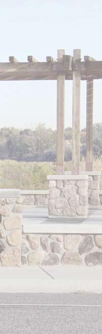
16 Gateway 6 George Washington Howard Amon Overlook Key Plan 6 LEGED Limit of Work Sign Location Primary Secondary ROW Design Considerations Gateway Type: Secondary Character: City Center eighborhood: Central Business District Experience: Mixed car & bike/ped Built Status: Existing gateway Context/otable Features: Connection to river front park, add city identifi er, screen food mart to the north of the gateway, arbor proposed for phase 2 will provide a tie-in to other gateway locations with arbors (gateways #5 and #10). Overview Plan Site photos City of Richland Gateway Design Report: Gateway Designs 59

.")
17 Gateway 6 George Washington Howard Amon Overlook Proposed Design Relocate existing sign across pathway and install on stone block pedestal to increase visibility and provide opportunity to add city of Richland logo. Proposed phase 2 pergola and stone pedestals are simulated with the same detailing and materials as the existing Lewis & Clark Overlook to demonstrate how this structure will provide a tie-in to other gateway locations with arbors (gateways #5 and #10). City of Richland Gateway Design Report: Gateway Designs 60


18 Gateway 7 George Washington Aaron Drive Key Plan 7 LEGED Limit of Work Sign Location Primary Secondary ROW Design Considerations Gateway Type: Primary Character: City eighborhood eighborhood: Experience: Mixed car & bike/ped Built Status: Existing gateway Context/otable Features: Stone shaped like WA state; apmplify presence of sign with landscape impromvements; provide buffer for neighboring residences. Overview Plan Site photos City of Richland Gateway Design Report: Gateway Designs 61


19 Gateway 7 George Washington Aaron Drive Proposed Design - Boulder Proposed Retrofit Design with Landscape Enhancements Preserve sign in existing location and increase presence with surrounding landscape improvements. Landscape improvements include: A single, sinuous row of large, evergreen trees, spaced approximately ft. on center. The understory would be planted with drought tolerant natives. An 6-8 ft. diameter bed of gravel immediately surrounding the sign. A 4-10 ft. diameter bed of ground covers and lowgrowing shrubs isurrounding the bed of gravel. City of Richland Gateway Design Report: Gateway Designs 62


20 Gateway 7 George Washington Aaron Drive Proposed Design - Boulder Proposed Retrofit Design with Landscape Enhancements Preserve sign in existing location and increase presence with surrounding landscape improvements. Landscape improvements include: A single, sinuous row of large, evergreen trees, spaced approximately ft. on center. The understory would be planted with drought tolerant natives. An 6-8 ft. diameter bed of gravel immediately surrounding the sign. A 4-10 ft. diameter bed of ground covers and lowgrowing shrubs isurrounding the bed of gravel. City of Richland Gateway Design Report: Gateway Designs 63


21 Gateway 8 Keene City Limits Key Plan 8 LEGED Limit of Work Sign Location Primary Secondary ROW Design Considerations Gateway Type: Minor Character: Residential eighborhood: Experience: Car/pedestrian (35 mph) Built Status: ew gateway location. Context/otable Features: Western entrance into Richland through residential neighborhood. Overview Plan Site photos City of Richland Gateway Design Report: Gateway Designs 64


22 Gateway 8 Keene City Limits Proposed Design Attach metal sign design to existing street light pole. City of Richland Gateway Design Report: Gateway Designs 65


23 Gateway 9 Key Plan Columbia Park City Limits 9 LEGED Limit of Work Sign Location Primary Secondary ROW Design Considerations Gateway Type: Primary Character: Park eighborhood: Experience: Mixed ped/bike and car Built Status: ew gateway Context/otable Features: Gateway location and design to respect this park as a shared asset with the City of Kennewick. Overview Plan Site photos City of Richland Gateway Design Report: Gateway Designs 66

24 Gateway 9 Columbia Park City Limits Option 1 Proposed - Boulder Design with Basalt - Black Text atural, park, waterfront context Precise location of gateway to be determined and may shift closer to the city of Richland to respect shared ownership of this open space with the city of Kennewick. City of Richland Gateway Design Report: Gateway Designs 67
25 Gateway 9 Columbia Park City Limits Option 1 Proposed - Boulder Design with Basalt - Metal Text atural, park, waterfront context Precise location of gateway to be determined and may shift closer to the city of Richland to respect shared ownership of this open space with the city of Kennewick. City of Richland Gateway Design Report: Gateway Designs 68


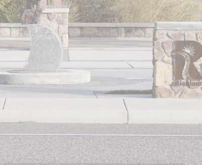
26 Gateway 10 Lewis & Clark Columbia Park Trail Key Plan 10 LEGED Limit of Work Sign Location Primary Secondary ROW Design Considerations Gateway Type: Minor Character: Park eighborhood: Experience: Mixed ped/bike and car Built Status: ew gateway applied to existing structures. Context/otable Features: Waterfront plaza overlooking the Columbia river with a statue of Sacagawea to commemorate the Lewis & Clark Expedition. Overview Plan Site photos City of Richland Gateway Design Report: Gateway Designs 69

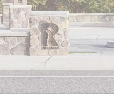
27 Gateway 10 Lewis & Clark Columbia Park Trail Option 1 - Richland Proposed Logo Design in Unfinished Steel 12 tall, unfinished cut steel Medallion style logo pin-mounted to the face of two existing stone columns. Color of steel blends with existing wood arbor. City of Richland Gateway Design Report: Gateway Designs 70
28 Gateway 10 Lewis & Clark Columbia Park Trail Option 2 - Richland Proposed Logo in Design Powder-coated metal 12 tall, powder coated cut metal Medallion style logo pin-mounted to the face of two existing stone columns. Use official city logo colors. City of Richland Gateway Design Report: Gateway Designs 71
29 Gateway 10 Lewis & Clark Columbia Park Trail Option 3 - Richland Proposed Logo in Design Powder-coated metal 12 tall, powder coated cut metal Medallion style logo pin-mounted to the face of two existing stone columns. Use black to reduce visual impact. City of Richland Gateway Design Report: Gateway Designs 72


30 Gateway 11 Columbia Center Fowler Street Key Plan 11 LEGED Limit of Work Sign Location Primary Secondary ROW Design Considerations Gateway Type: Secondary Character: Suburban eighborhood: Experience: Car dominant Built Status: Existing gateway Context/otable Features: Soften dry landscape; opportunity for a district size gateway. Overview Plan Site photos City of Richland Gateway Design Report: Gateway Designs 73


31 Gateway 11 Columbia Center Fowler Street Proposed Proposed Design Design - Retrofit Increase visibility of existing sign by installing it on a concrete pedestal that is raised up approximately 12 and hidden behind additional shorter basalt columns. Amplify presence of gateway by supplementing existing basalt columns with anoter 5-6 columns on either side. Soften basalt with landscape plantings in front of newly installed columns. Replace broken face basalt to the left of the sign. City of Richland Gateway Design Report: Gateway Designs 74


32 Gateway 12 Leslie Amon Creek atural Preserve Key Plan Amon Creek ature Preserve LEGED Limit of Work Sign Location Amon Creek Access Road 12 Primary Secondary Leslie Road ROW Design Considerations Gateway Type: Primary Character: Park/atural Area eighborhood: Experience: Mixed ped/bike and car Built Status: ew gateway Context/otable Features: atural character of Amon Creek atural Preserve. Overview - Existing Plan Conditions Site photos City of Richland Gateway Design Report: Gateway Designs 75


33 Gateway 12 Leslie Amon Creek atural Preserve Proposed Design Blend with natural context of Amon Creek Preserve. Locate gateway sign on natural high point, just north of the preserve s access road. See following plan for specific location. Landscape plantings to draw heavily from local palette of native plants. City of Richland Gateway Design Report: Gateway Designs 76


34 Gateway 12 Leslie Amon Creek atural Preserve Proposed Design Sign stone Columnar Basalt Landscape Boulders (Set at grade, 4-6 tall, max.) Scree Plantings Leslie Road ROW Buffer Perspective Site Plan Elevation City of Richland Gateway Design Report: Gateway Designs 77


35 Gateway 13 Columbia Center Blvd. SR 240 Key Plan LEGED Limit of Work Sign Location 13 Primary Secondary ROW Design Considerations Gateway Type: Minor Character: Highway Overpass eighborhood: Experience: Freeway perspective Built Status: ew gateway Context/otable Features: Overpass architecture has prominent columns with tall parapet. Overview Plan Site photos City of Richland Gateway Design Report: Gateway Designs 78


36 Gateway 13 Columbia Center Blvd. SR 240 Proposed Design Expression of natural forms found in and around Richland; the hills, river, delta, islands, vineyards, and technology are all referenced in this design. Parameters for installation to meet standards of WSDOT DESIG MAUAL CHAPTER Criteria for Public Art City of Richland Gateway Design Report: Gateway Designs 79


37 Gateway 14 I-182 SR 240 Key Plan LEGED 14 Limit of Work Sign Location Primary Secondary ROW Design Considerations Gateway Type: Minor Character: Highway Overpass eighborhood: Experience: Car dominant Built Status: ew gateway Context/otable Features: Overview Plan Site photos City of Richland Gateway Design Report: Gateway Designs 80


38 Gateway 14 I-182 SR 240 Proposed Design Expression of natural forms found in and around Richland; the hills, river, delta, islands, vineyards, and technology are all referenced in this design. Parameters for installation to meet standards of WSDOT DESIG MAUAL CHAPTER Criteria for Public Art City of Richland Gateway Design Report: Gateway Designs 81


39 Gateway 15 I-182 Keene Road Key Plan 15 LEGED Limit of Work Sign Location Primary Secondary ROW Design Considerations Gateway Type: Minor Character: Highway Overpass eighborhood: Experience: Car dominant with some bike/ped Built Status: ew gateway Context/otable Features: Freeway pillars can support art; overpass will be retrofi tted for a bike/ped trail; draw from other freeway art (Rainbow in Phoenix and Yakima Sunburst) Overview Plan Site photos City of Richland Gateway Design Report: Gateway Designs 82


40 Gateway 15 I-182 Keene Road Proposed Design Expression of natural forms found in and around Richland; the hills, river, delta, islands, vineyards, and technology are all referenced in this design. Parameters for installation to meet standards of WSDOT DESIG MAUAL CHAPTER Criteria for Public Art City of Richland Gateway Design Report: Gateway Designs 83


41 Gateway 16 WSDOT Sign WICO Key Plan 16 LEGED Limit of Work Sign Location Primary Secondary ROW Design Considerations Gateway Type: Primary Character: City Center eighborhood: Central Business District Experience: Car dominant with some bike/ped Built Status: ew gateway Context/otable Features: Use WSDOT signbridge to mount new city center sign; high priority, coordination with WSDOT required. Overview Plan Site photos City of Richland Gateway Design Report: Gateway Designs 84


42 Gateway 16 WSDOT Sign WICO Proposed Design Two potential options currently being reviewed by WSDOT. City of Richland Gateway Design Report: Gateway Designs 85


43 Gateway 17 Steptoe Columbia Park Trail Key Plan 17 LEGED Limit of Work Sign Location Primary Secondary ROW Design Considerations Gateway Type: Secondary Character: Undeveloped eighborhood: Experience: Car dominant Built Status: ew gateway Context/otable Features: Locate past existing Columbia Park Trail sign and along approach to new traffi c circle at intersection of Steptoe St. and Columbia Park Trail. Overview Plan Site photos City of Richland Gateway Design Report: Gateway Designs 86


44 Gateway 17 Steptoe Columbia Park Trail Proposed Design ew sign location will compete less with other existing signs along Steptoe St. and can welcome visitors as they approach newly built round-a-bout. City of Richland Gateway Design Report: Gateway Designs 87


45 Gateway 18 Key Plan Gage Bellerive Drive LEGED Limit of Work Sign Location Primary Secondary ROW Design Considerations Gateway Type: Secondary Character: Commercial/Residential eighborhood: Experience: Car dominant with ped Built Status: ew gateway Context/otable Features: Use location of existing sign and replace with new sign design. Overview Plan Site photos City of Richland Gateway Design Report: Gateway Designs 88

46 Gateway 18 Gage Bellerive Drive Proposed Design Replace existing sign with new sign design. City of Richland Gateway Design Report: Gateway Designs 89
section five BEAUTIFICATION PLAN
 section five BEAUTIFICATION PLAN BEAUTIFICATION PLAN Section Five Beautification Plan The goal of the Beautification Plan is to improve the Route 8-Sunnyland Corridor in terms of aesthetics and to create
Route 347. New York State Department of Transportation Region 10, Long Island. THE GREENING of ROUTE 347
 The GREENING of Route 347 The Greening of Route 347 The Greening of Route 347: History 3 The Greening of Route 347 4 The Greening of Route 347 5 The Greening of Route 347 Smith Haven Mall 6 The Greening
4. INDUSTRIAL 53 CASTLE ROCK DESIGN
 4. INDUSTRIAL 53 CASTLE ROCK DESIGN CASTLE ROCK DESIGN 54 4. INDUSTRIAL Overview Well-designed and attractive industrial centers are the product of blending economic realities with both functional and
V. Gateways GATEWAYS / V-1
 V. GATEWAYS / V-1 Many of Chesapeake s gateways are located on highways and call for bold and attractive designs that motorists can understand, appreciate, and enjoy. can also take the form of natural
Campus Master Plan Description Section 6 Storm water management and people places at campus buildings. Section 6 Campus MP Description
 Campus Master Plan Description Section 6 Storm water management and people places at campus buildings Section 6 Campus MP Description THIS PAGE INTENTIONALLY LEFT BLANK. appendix The following provides
Blue Line LRT Extension
 v e Noble Pkwy Noble Pkwy Xerxes Ave N Shingle Creek Penn Ave N Penn Ave N Fremont Ave N Lyndale Ave N S Washington Ave University Ave NE Blue Line LRT Extension LIGHT RAIL PLATFORM AND STATION DESIGN
Overview of the Plan. The Building Blocks of Centers, Neighborhoods and Network INTERNAL DRAFT
 Overview of the Plan 4 East Davidson Ramah Church Rd June Washam Rd Bradford District Park Bradford Shearer Rd Campus District NC 73 Davidson-Concord North Rocky River This Master Plan projects an approximate
3.13. Development Guidelines
 3.3 Landscaping Elements Landscaping should be used to frame and soften structures, define site functions, enhance the quality of the environment, and screen undesirable views. Safety, environmental impacts,
124 Subarea Visions. Vision Plan. A. Nelessen Associates, INC I Visioning I Planning I Urban Design
 Subareas 124 Subarea Visions The next seven sections describe specific recommendations tailored to each subarea. Each subarea is discussed separately except for certain aspects of 95th Street and Antioch
RZC Public View Corridors and Gateways
 RZC 21.42 Public View Corridors and Gateways 21.42.010 Purpose 21.42.020 Scope and Authority 21.42.030 Administration 21.42.040 Gateways Design 21.42.050 Unidentified Public Views 21.42.060 Identification
VEHICULAR AND PEDESTRIAN CIRCULATION
 This perspective sketch communicates the intended character and quality of a proposed streetscape design. Locate benches near a major intersection where people tend to gather. Seating and lighting provide
Hidden Pointe Landscape Master Plan. June, archi terra
 Hidden Pointe Landscape Master Plan June, 2006 t h e archi terra g r o u p 1 Table of Contents Background Purpose and Goals of the Master Plan Master Plan Process Existing Conditions Entrance Hidden Pointe
COMMUNITY DESIGN. GOAL: Create livable and attractive communities. Intent
 COMMUNITY DESIGN Intent An attractive, well-designed County will attract quality development, instill civic pride, improve the visual character of the community, and create a strong, positive image for
Rosslyn Plaza PDSP (SP #422) SPRC Staff Presentation
 SPRC Staff Presentation") Rosslyn Plaza PDSP (SP #422) SPRC Staff Presentation ote Guiding Principles included in this document are taken from the latest working draft of the Guiding Principles dated. The illustrations included
Rosslyn Plaza PDSP (SP #422) SPRC Staff Presentation ote Guiding Principles included in this document are taken from the latest working draft of the Guiding Principles dated. The illustrations included
FDOT D4 Complete Streets
 FDOT D4 Complete Streets Context Sensitive Solutions Directs that complete street solutions will complement the context of the community. Collaborative approach to decision making, project development,
PIKE PINE RENAISSANCE: ACT ONE. October 19, 2017
 PIKE PINE RENAISSANCE: ACT ONE October 19, 2017 WATERFRONT SEATTLE PROGRAM PROJECT INTRODUCTION Pike and Pine streets, between First and Melrose avenues Pedestrian and streetscape improvements Budget:
Subarea 4 Indian Creek. Vision The combination of park networks and transportation amenities make Subarea 4 the greenest hub in the Corridor.
 indian creek 180 extends south from 101st Street to I-435. The I-435 and Metcalf intersection is one of the primary intersections in the Kansas City Metro Area. The area includes several residential neighborhoods
Subarea 5 Southern Gateway. Vision. Mobility The proposed street network will create developable blocks that are scaled appropriately for the area.
 southern gateway 194 Southern Gateway extends south of I-435 to 123 rd Street and includes the area past the Blue Valley Parkway division. This area is adjacent to major office centers such as the College
The University District envisions, in its neighborhood
 Envisioning the University District Link Light Rail in Seattle s neighborhoods CIY OF SEALE CONCEP-LEVEL SAION AREA PLANNING RECOMMENDAION RESOLUION # 30165 EXHIBI L Vision 08.2000 he University District
AESTHETIC APPEARANCE. Design Guidelines for Grade-Separated Pedestrian, Cyclist and Equestrian Structures
 III. AESTHETIC APPEARANCE The aesthetic qualities of a grade-separated structure are as important as the specific design criteria. For example, a structure may be constructed to the exact criteria set
Welcome to the Sellwood Bridge Project Pre-Construction Open House
 Welcome to the Sellwood Bridge Project Pre-Construction Open House 5:30 7:30 p.m. Please sign in here Information stations and project staff are located throughout the room. Goals for Tonight s Meeting
Northwest Rail Corridor and US 36 BRT Development Oriented Transit Analysis 4.4 STATION AREA FINDINGS
 4.4 STATION AREA FINDINGS Each station is different, and each one requires a separate set of recommendations based on the vision for the site. This section outlines an initial TOD strategy and recommendations
OPPORTUNITIES AND CONSTRAINTS - OXBOW PARK ENTRANCE AND PUT-IN
 OPPORTUNITIES AT OXBOW EXISTING WETLANDS Site is undeveloped and we can design a park that works well from the start. SAND BEACH Potential to eliminate invasive species. DEBRIS (CONCRETE, OLD CARS) VEGETATION
BRADENTON RIVERWALK EXPANSION MASTER PLAN
 BRADENTON RIVERWALK EXPANSION MASTER PLAN INTRODUCTION & AGENDA Process Update Community Engagement Summary Center for Active Design (CfAD) Recommendations Context and Existing Conditions Master Plan Alternatives
WEST LOOP DESIGN GUIDELINES CHECKLIST
 WEST LOOP DESIGN GUIDELINES CHECKLIST Section 1.0 General Strategies 1.1 DESIGN EXCELLENCE: ENCOURAGE HIGH QUALITY AND INNOVATIVE DESIGN OF NEW BUILDINGS WITHIN THE WEST LOOP WITHOUT BEING PRESCRIPTIVE
PROJECT SITE The Proposed Project includes the Allen and Pike Street malls between Delancey and South Streets (see Figure 2C-1).
.") Chapter 2, Section C: A. INTRODUCTION This chapter considers the potential of the proposed Reconstruction of the Allen and Pike Street Malls project to affect the urban design characteristics and visual
Chapter 2, Section C: A. INTRODUCTION This chapter considers the potential of the proposed Reconstruction of the Allen and Pike Street Malls project to affect the urban design characteristics and visual
Concept One soldier s formation
 Concept One soldier s formation PLA clear zone new trees to fill in existing gaps/ patterns as feasible existing trees (typ.) maintained shoulder TH 22 symbolic shrub rows basalt columns (5 locations)
FREEWAY/TOURIST DISTRICT
 FREEWAY/TOURIST DISTRICT DESIGN STANDARDS FOR THE CITY OF MOUNTLAKE TERRACE March, 2014 MOUNTLAKE TERRACE FREEWAY/TOURIST DESIGN STANDARDS March, 2014 1 TABLE OF CONTENTS Introduction...1 Design Site Design
ATTACHMENT A. SILVERDALE DESIGN STANDARDS Amendments to the Waaga Way Town Center Chapter
 ATTACHMENT A SILVERDALE DESIGN STANDARDS Amendments to the Waaga Way Town Center Chapter Chapter 10. Waaga Way Town Center 10.1 Physical Identity Elements & Opportunities The Waaga Way Town Center includes
Visually Appropriate Accessible Pavement for Historical Sites. Fort Vancouver. National Historic Site Reconstructed Hudson Bay Company Fort
 Visually Appropriate Accessible Pavement for Historical Sites Fort Vancouver National Historic Site Reconstructed Hudson Bay Company Fort The National Park Service has improved accessibility by installing
A.9. Cannon River. Campostella Park. Adjacent Industrial & City Facility Uses
 Campostella Park Classification: Nature Area 14 acres Character: This park is an undeveloped, heavily wooded natural open space park located along the Cannon River, just to the southwest of Babcock Park
Urban Design 9Identity
 Urban Design 9Identity URBAN DESIGN IDENTITY Urban design is about connecting people to their places through the built environment, nature, and overall urban form. Done well, it creates a memorable space
POCKET COMMUNITY PLAN
 POCKET COMMUNITY PLAN Part Three : COMMUNITY PLAN AREAS AND SPECIAL STUDY AREAS CONTENTS Community Location... 3-P-3 Community Vision... 3-P-4 Community Profile... 3-P-4 Community Issues... 3-P-6 Land
Lower Merion Commercial Districts Issues and Characteristics Handbook November 2013
 Lower Merion Commercial Districts Issues and Characteristics Handbook November 2013 DRAFT TOWNSHIP-WIDE VISION: To maintain and enhance commercial areas to complement the surrounding high-quality residential
City of Farmington. Downtown Plan. Amendment to the 1998 Master Plan Adopted October 11, 2004
 City of Farmington Amendment to the 1998 Master Plan Adopted October 11, 2004 Introduction Planning Background 1 Scope and Components of the Plan Amendment 2 Concept Introduction 3 Plan Concepts 3 Conceptual
Town Center. Block 5 Existing multifamily residential units are expected to remain.
 Area Guidelines Germantown s districts should be developed as distinct communities with unique features that are supported through the guidelines. The guidelines not only help distinguish these districts
INSTITUTIONAL USE DESIGN COMPATIBILITY TECHNIQUES
 INSTITUTIONAL USE DESIGN COMPATIBILITY TECHNIQUES INTRODUCTION Community institutions are an important part of the character and vitality of neighborhoods in Forsyth County. Institutional uses include
Chapter 14 Streetscape Improvements
 This chapter presents streetscape design concepts for key streets and gateways in the Downtown Specific Plan area. This chapter is organized as follows: 14 Streetscape Improvements 14.1 Streetscape Treatments
CHAPTER 5 Public Realm Improvements
 5.1 OVERVIEW This chapter focuses on the public realm, that is, spaces within and directly adjacent to public rights-of-way (ROWs), including streets, Oso Creek, the rail corridor, and the freeway edge.
New-Cast Mixed-use Development Proposal King Street West, Newcastle, Ontario
 URBAN DESIGN BRIEF New-Cast Mixed-use Development Proposal King Street West, Newcastle, Ontario TABLE OF CONTENTS: 1.0 Executive Summary 2.0 Creating Vibrant and Sustainable Urban Places: Excerpts from
Norwood Public Library Rendering
 The new Norwood Public Library is based on a lot that is a few blocks south of Highway 145 (Main Street) in Norwood, Colorado at the intersection of Pine Street and San Miguel Street. It is owned by the
Appendix A COMMUNITY IMPROVEMENT PLAN DESIGN GUIDELINES
 Appendix A COMMUNITY IMPROVEMENT PLAN DESIGN GUIDELINES INTRODUCTION The continuous and desirable improvement of Arnprior requires a clear understanding of what is envisioned for the Town. These Design
L L O T DESIGN GUIDELINES. Landscaping
 S M AL L L O T DESIGN GUIDELINES Landscaping Landscaping The landscape of a small lot project can be divided into three areas. This provides a helpful framework for designing a cohesive landscape plan.
Landscape and Streetscape Design 2.5
 Landscape and Streetscape Design 2.5 2.5.1 Goals 2.5.2 Planting 2.5.3 Sidewalks and Pavement 2.5.4 Furnishings 2.5.5 Walls 2.5.6 Lighting 2.5.7 Stormwater 2.5.8 Street Cross Sections 2.5 LANDSCAPE AND
5.8 Visual Resources and Aesthetic Qualities
 I-70 East Supplemental Draft EIS 5.8 Visual Resources and Aesthetic Qualities 5.8 Visual Resources and Aesthetic Qualities This section discusses the visual resources and aesthetic qualities of the study
public review draft Key objectives for this chapter are:
 5 - parks & open space Providing a rich collection of outdoor places for informal gathering and recreation, as well as planned promotional activities and community events, is a key concept for Midtown.
COMMERCIAL & INDUSTRIAL DESIGN GUIDELINES CITY OF RANCHO CUCAMONGA PLANNING DIVISION
 COMMERCIAL & INDUSTRIAL DESIGN GUIDELINES CITY OF RANCHO CUCAMONGA PLANNING DIVISION INTRODUCTION These guidelines were prepared in response to the needs of many users: developers, property owners, architects,
Mississauga Waterfront. Parks Strategy - Draft
 Potential configuration for river s edge seating. Boating on Credit River: A regatta Boating on Credit River: Active enjoyment 5.2 Port Credit Memorial Park West Priority Park 5.2.1 Site Opportunities
Community Mixed Use Zone Districts (CMU)
") 18.28.500 Community Mixed Use Zone Districts (CMU) The Community Mixed Use Zone Districts (CMU) are intended to help implement the land use goals and strategies found in the Golden Vision 2030 values,
18.28.500 Community Mixed Use Zone Districts (CMU) The Community Mixed Use Zone Districts (CMU) are intended to help implement the land use goals and strategies found in the Golden Vision 2030 values,
12 Foot Davis and Adjacent Sites
 Peace River, Alberta Proposed Concept Design Presentation and Discussion January 26, 2010 Peace River Provincial Recreation Area 12 Foot Davis Grave Site Dr. Greene Cairn North Environments Landscape Architects
4 C OMMUNITY D ISTRICTS
 4 C OMMUNITY D ISTRICTS N ew development in the Area will include many different types of land uses, including a destination retail area that attracts people from all over the region; recreation opportunities
Stakeholder Workshop #2
 Welcome! W3 th Realignment Study Stakeholder Workshop #2 We are pleased you are here to help advance the study, and we are eager to hear your ideas. How to get the most out of this workshop: Listen to
THE NEIGHBORHOOD TODAY
 THE NEIGHBORHOOD TODAY CORE AREA VISION How are we Good Urbanism A Site s DNA thinking about Elements of great Unique elements urban communities embedded in a place the site and design? ELEMENTS LIKE:
I-70 Corridor Enhancement Plan
 i - Table of Contents Table of Contents Chapter I Overview Chapter II Bridge and Roadway Improvements Chapter III Landscape Enhancements Chapter IV Riparian Corridors Chapter V Showcase Missouri Plan Chapter
5.1.1 The streetscape along US Highway 64 (Brevard Road); and, The built environment within new residential developments; and,
; and, The built environment within new residential developments; and,") Article 5. Landscaping 5.1 Purpose The Town of Laurel Park s landscape standards are designed to create a beautiful, aesthetically pleasing built environment that will complement and enhance community
Article 5. Landscaping 5.1 Purpose The Town of Laurel Park s landscape standards are designed to create a beautiful, aesthetically pleasing built environment that will complement and enhance community
SECTION TWO: Overall Design Guidelines
 SECTION TWO: Overall Design Guidelines This section provides overall design principles and guidelines for the Gardnerville Mixed-use Overlay. They provide criteria for mixed-use places consisting of residential,
Chapter 5: Mixed Use Neighborhood Character District
 5: Mixed Use Neighborhood Character District 5.1 Introduction The Mixed Use Neighborhood character district acts as a transition or bridge between the State Route 89A District s commercial area to the
B. PROPOSED REFINEMENTS POTENTIALLY AFFECTING URBAN DESIGN AND VISUAL RESOURCES
 Chapter 4: Urban Design and Visual Resources A. CONCLUSIONS OF THE FGEIS The FGEIS concluded that the Approved Plan will not result in any significant adverse impact on urban design or visual resources.
Appendix B - Design Standards and Guidelines November 18, 2015 B-35
 Avila Ranch Figure B-28: R-1 Residential Landscape Palette Figure B-29: R-2 Residential Landscape Palette B-35 Figure B-30: Residential Landscape Palette B-36 Avila Ranch E.2 Buildings Buildings placed
New Stanton Project Update July 3, 2012
 New Stanton Project Update July 3, 2012 The Needs BACKGROUND INFO I-70 Geometric Concerns Substandard Horizontal & Vertical Clearance at Center Ave. Bridge (The Center Avenue Bridge is Replaced in all
LOS ANGELES MISSION COLLEGE MASTER PLAN Master Plan DESIGN & DEVELOPMENT PRINCIPLES
 LOS ANGELES MISSION COLLEGE MASTER PLAN DESIGN & DEVELOPMENT PRINCIPLES 34 Quality Learning Along the Arroyo PROGRAM SUMMARY BY PROJECT The following are program summaries for each of the projects planned
WESTSIDE SUBWAY EXTENSION PROJECT. Addendum to the Visual and Aesthetic Impacts Technical Report
 PROJECT to the Visual and Aesthetic Impacts Technical Report August 2011 Visual and Aesthetic Impacts Technical Report SUMMARY On October 28, 2010, the Metro Board selected the Westwood/VA Hospital Extension
DEVELOPMENT CONTROLS MEDICAL DISTRICT
 6.01. GENERAL DESIGN GUIDELINES A. Site Planning B. Architectural Design C. Medical Facility Signage & Lighting D. Exhibit 48. ARCHITECTURAL DESIGN CONCEPTS 6.02. MEDICAL FACILITY STANDARDS & GUIDELINES
University of Washington Burke Gilman Trail Corridor Study
 Civil Engineering Landscape Architecture Environmental Restoration Planning University of Washington Burke Gilman Trail Corridor Study Dave Rodgers, PE, LEED AP March 10, 2011 Guiding Principles Design
URBAN DESIGN BRIEF URBAN DESIGN BRIEF 721 FRANKLIN BLVD, CAMBRIDGE August 2018
 URBAN DESIGN BRIEF URBAN DESIGN BRIEF 721 FRANKLIN BLVD, CAMBRIDGE August 2018 DESIGN BRIEF CONTENTS PART A 1.0 INTRODUCTION 2.0 DESCRIPTION & ANALYSIS OF SITE CONTEXT 3.0 DESIGN CONSTRAINTS AND OPPORTUNITIES
URBAN DESIGN BRIEF 305, 309, & 315 SOUTHDALE ROAD WEST LONDON ONTARIO
 URBAN DESIGN BRIEF 305, 309, & 315 SOUTHDALE ROAD WEST LONDON ONTARIO CARVEST PROPERTIES LTD. December 2013 Section 1 - Land Use Planning Context 1.1 Subject Lands The subject lands are located immediately
FINAL. Appendix A: Figure Viewpoint 1 View from Nurragingy Reserve (North) Proposed Modification to RDC, Rooty Hill
 Proposed Modification to RDC, Rooty Hill") Viewpoint 1 Existing View from Nurragingy Reserve (North) Photo taken 01/06/2010-11:45am - (facing Southwest) Outline of Proposed Storage Bins and Noise Wall Viewpoint 1 Proposed View from Nurragingy Reserve
Viewpoint 1 Existing View from Nurragingy Reserve (North) Photo taken 01/06/2010-11:45am - (facing Southwest) Outline of Proposed Storage Bins and Noise Wall Viewpoint 1 Proposed View from Nurragingy Reserve
Daniels Park Master Plan
 Daniels Park Master Plan Prepared for: Douglas County & The City and County of Denver October, 2007 EXHIBIT A Contents Daniels Park Overview 2 Project History & Goals 2-3 Regional Context Map 4 Park Zone
APPENDIX D: Visual and Aesthetic Conditions for NCCU Station Refinement. Durham-Orange Light Rail Transit Project
 APPENDIX D: Visual and Aesthetic Conditions for NCCU Station Refinement Durham-Orange Light Rail Transit Project October 2016 1. Introduction The Combined FEIS/ROD summarizes the effects of the D-O LRT
Community Design Plan
 Gardena General Plan 2006 Authority While the is not a required element of a General Plan, it is included because improving the community appearance and image is paramount to the overall quality of life
12/9/2013. HOLLYWOOD/PINES CORRIDOR PROJECT AMPO 2013 Annual Conference October 24, Our Perspective. Broward.
 HOLLYWOOD/PINES CORRIDOR PROJECT AMPO 2013 Annual Conference October 24, 2013 Our Perspective Broward Fort Lauderdale 1 Broward Metropolitan Planning Organization Fort Lauderdale Fort Lauderdale Skyline
URBAN DESIGN BRIEF REPORT
 URBAN DESIGN BRIEF REPORT PREPARED FOR 2568401 ONTARIO INC NEW GASBAR, CONVENIENCE STORE & CARWASH DEVELOPMENT @ 1509 FANSHAWE PARK ROAD WEST LONDON, ONTARIO GAMA ENGINEERING INC. PROJECT NUMBER 1669 PREPARED
7. SITE DESIGN, RETAINING
 7. SITE DESIGN, RETAINING WALLS AND DETENTION 99 CASTLE ROCK DESIGN CASTLE ROCK DESIGN 100 7. SITE DESIGN, RETAINING WALLS AND DETENTION Overview and Goals These guidelines apply to all residential, commercial,
OVERLAKE VILLAGE STATION
 OVERLAKE VILLAGE STATION Today NEIGHBORHOOD CONTEXT PLAN NEIGHBORHOOD CONTEXT PLAN WITH DEVELOPMENT 148TH AVE NE 1/4-MILE RADIUS NE 36TH ST BUS ROUTE BICYCLE ROUTE S.R. 520 NE 31TH ST PEDESTRIAN-BICYCLE
M E M O R A N D U M July 27, 2018
 M E M O R A N D U M July 27, 2018 To: Southlake 2035 Corridor Planning Committee From: Kenneth Baker, Sr. Director of Planning and Development Services Subject: Item #6 First National Bank Purpose Review,
Community Meeting November 18, 2015
 Top Concerns We ve Heard Use of Urban Road Code Total number of units and effect on schools and transportation Land swaps with Parks Department: how do these benefit the community? Zoning classifications:
Corridor Enhancements
 Corridor Enhancements Safety is MoDOT s first priority in widening and rebuilding I-70 across the state of Missouri. MoDOT also understands that the interstate - and its interchanges and overpasses - are
CHAPTER FIVE COMMUNITY DESIGN
 CHAPTER FIVE COMMUNITY DESIGN CHAPTER FIVE - COMMUNITY DESIGN Assumptions Frazier Park and Lebec have historically developed according to different patterns of spatial form. While both communities are
3. Urban Design in the Central Area
 3. Urban Design in the Central Area The Central Area Planning and Design Group assumes the responsibility to promote high quality urban and architectural design in the Central Area, plan and ensure the
Division VI Community Mixed Use (CMU) Architectural Guidelines and Standards
 Architectural Guidelines and Standards") Division VI 18.40.800 Community Mixed Use (CMU) Architectural Guidelines and Standards 18.40.810 Guidelines The goals of the Comprehensive Plan include a focus on pedestrian safety, amenities and aesthetics
Division VI 18.40.800 Community Mixed Use (CMU) Architectural Guidelines and Standards 18.40.810 Guidelines The goals of the Comprehensive Plan include a focus on pedestrian safety, amenities and aesthetics
3.5 VISUAL AND AESTHETIC QUALITIES
 3.5 VISUAL AND AESTHETIC QUALITIES 3.5.1 Introduction to Analysis 3.5.1.1 Summary of Results The Preferred Alternative would represent a minimal change to the visual character of the existing rail corridor.
Potential Green Infrastructure Strategies May 6, 2015 Workshop
 Potential Green Infrastructure Strategies May 6, 2015 Workshop Background The City of Cortland is developing the Tioughnioga Urban Headwaters Green Infrastructure Action Plan with funding from the National
D. Landscape Design. 1. Coverage Intent: To provide adequate landscaping materials that enhance the appearance of development projects.
 D. Landscape Design The standards and guidelines in this section give design guidance for the landscaping components of industrial and office projects. City regulations require that all landscaping be
L 4-1. Heritage Report: Reasons for Heritage Designation. Kodors House. 35 Rosedale Avenue West
 L 4-1 Brampton Heritage Board Date: January 17, 2012 Heritage Report: Reasons for Heritage Designation Kodors House 35 Rosedale Avenue West December 2011 1 L 4-2 Profile of Subject Property Municipal Address
Design Guidelines. Roosevelt. Mike Podowski DPD Design Guidelines Ordinance ATT 13 August 13, 2012 Version #1
 Roosevelt Design Guidelines The Roosevelt Neighborhood Design Guidelines apply within the Neighborhood Boundary. Map 1 2 Map 2 3 Map 3 4 CS1 Natural Systems and Site Features Citywide Guideline: Use natural
Connecting Key Activity Centers with High Quality Bus Service
 Connecting Key Activity Centers with High Quality Bus Service Lessons Learned from the DC Circulator Transit Development Plan April 15, 2011 1 DC Circulator Transit Development Plan Ten-year plan for development
SECTION TWO: Urban Design Concepts
 SECTION TWO: Urban Design Concepts The Gardnerville Plan for Prosperity shapes economic opportunities presented by regional growth. The Urban Design Concepts provide policies and concepts for land use,
3.0 master plan concept
 3.0 master plan concept 3.1 introduction The purpose of the Huron Church Road Master Plan Concept is to provide an overview of the Master Plan design process, identify preliminary streetscape installations
Pipeline Trail Master Plan Preliminary Concept Design. O Connor Mokrycke Consultants May 14, 2015 meeting
 Pipeline Trail Master Plan Preliminary Concept Design O Connor Mokrycke Consultants May 14, 2015 meeting 1 Purpose of the Meeting: - Share information regarding traffic studies - Present ideas arising
The Anaheim Resort Public Realm Landscape Program. City of Anaheim. Adopted September 1994 (94R-239)
") Public Realm Landscape Program City of Anaheim Adopted September 1994 (94R-239) Amendment No. 1 October 1996 (96R-178) Amendment No. 2 June 1999 (99R-137) Amendment No. 3 February 2001 (2002R-56) Amendment
Public Realm Landscape Program City of Anaheim Adopted September 1994 (94R-239) Amendment No. 1 October 1996 (96R-178) Amendment No. 2 June 1999 (99R-137) Amendment No. 3 February 2001 (2002R-56) Amendment
Hamilton Road Corridor Streetscape Master Plan. Open House October 4 th, 2017
 Hamilton Road Corridor Streetscape Master Plan Open House October 4 th, 2017 Agenda 1. Introductions Agenda Overview 2. Project Background 3. Existing Conditions 4. Strengths, Weaknesses, Opportunities
Commercial Development Permit Area
 City of Kamloops KAMPLAN Commercial Development Permit Area PURPOSE The purpose of this Development Permit Area (DPA) is to establish objectives and provide guidelines for the form and character of commercial
Chapter 7: Streetscape & Design Elements
 OVERVIEW Chapter 7: Streetscape & Design Elements During the public input phase of The Dixie Fix, the area of streetscape generated much interest. While safety and traffic flow are primary objectives of
2.5 Roads. Loading and service areas adjacent to Highway 401 should be screened through architectural walls and/or landscape buffer planting.
 N HIGHWAY OFF RAMP 2.5 Roads A legible road network with a clear hierarchy will help create a connected community, both within and surrounding the Milton Heights. The following section outlines the proposed
Glenborough at Easton Land Use Master Plan
 Public Facilities 102 7.0 PUBLIC FACILITIES 7.1 OVERVIEW This chapter describes the public facilities that will provide high-quality services in the Glenborough at Easton community, to include three schools,
Long Branch-Wayne Local Park Renovation Project
 Montgomery Parks Long Branch-Wayne Local Park Renovation Project Community Meeting #2 September 20, 2016 Oak View Elementary School 7:00-9:00 PM Welcome / Team Introductions M-NCPPC (Montgomery Parks)
Century Park to Ellerslie Road Preliminary Engineering
 Century Park to Ellerslie Road Preliminary Engineering South LRT Extension Stakeholder Information Panel Brochure March 2010 www.edmonton.ca/lrtprojects LRT Station (left) and Transit Centre Architectural
M E M O R A N D U M January 6, 2017
 Item #4 M E M O R A N D U M January 6, 2017 To: 2035 Corridor Planning Committee From: Kenneth Baker, Sr. Director of Planning and Development Services Subject: Item #4 Overview Fidelis Purpose: Review
DESIGN GUIDELINES. Seattle Children s Major Institution Master Plan. Approved May 7, 2010
 Approved May 7, 2010 Contact: Todd Johnson, todd.johnson@seattlechildrens.org, (206)987-5259 A. MASTER PLAN... 3 A1.0 Context... 3 A1.1 Purpose of Design Guidelines... 3 A1.2 Design Guidelines... 4 B....
Standards (R-3) Figure B-11: R-3 Residential Standards Exhibit
 Figure B-11: R-3 Residential Standards Exhibit") Avila Ranch Avila Ranch Specific Plan Development Standards High Medium Density - High Residential Density Residential Lot and Building Lot and Standards Building (R-3) Standards (R-3) EXAMPLES These sketches
Avila Ranch Avila Ranch Specific Plan Development Standards High Medium Density - High Residential Density Residential Lot and Building Lot and Standards Building (R-3) Standards (R-3) EXAMPLES These sketches