University of Washington Burke Gilman Trail Corridor Study
|
|
|
- Derick McDaniel
- 6 years ago
- Views:
Transcription


1 Civil Engineering Landscape Architecture Environmental Restoration Planning University of Washington Burke Gilman Trail Corridor Study Dave Rodgers, PE, LEED AP March 10, 2011
 Accommodate growth from surrounding projects Preserve")
2 Guiding Principles Design BGT as transportation facility for intra-campus and regional travel Balance with aesthetic interests and UW Identity Reduce & minimize conflicts (ped/bike) Accommodate growth from surrounding projects Preserve trees

3 History National Example of Rail to Trail conversion and preservation Former Seattle, Lakeshore and Eastern RR Mountains to Sound Current Ownership

4 A Facility of Regional Importance Seattle Bicycle Master Plan PSRC Vision 2040 King County Regional Trail Network Lake Washington Loop

5 The Burke-Gilman is also a Campus Facility Connections to: Transit Sports venues Recreation UWMC Housing Nearby shopping


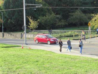
6 Current Observations Intersections Width Sightlines Ped/Bicycle Conflicts


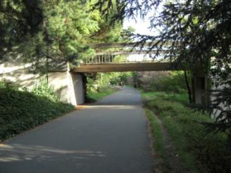
7 Current Observations University Bridge Brooklyn University Avenue 15 th Avenue


8 Current Observations Hitchcock Bridge T-Wing Bridge Rainier Vista/Montlake Triangle


9 Current Observations Wakiacum/Mercer Pend Orielle

10 Future Determinants of Demand Regional and city growth in bicycle use New LINK service Bike to transit Pedestrian demand Bike on transit Montlake Triangle trip distribution SR 520 expansion Streetcar West Campus Housing Planned improvements to Montlake Triangle/Rainier Vista and Pend Oreille
11 Traffic Counts October 2010 Video Count Locations Growth Rates Bike Ped
12 Projected Growth

13 Level of Service Analysis Previous Modeling SUPLOS Modeling LOS Determination with Existing Geometry Implications
14 Separation of Uses New measurement of LOS Impact Width of facilities Vertical Separation Lateral Separation

15 Corridor Design Elements Trail Width Separation of Wheeled and Ped Uses (Danish Influence)


16 Design Elements Trail Surface Trail Traffic management Vertical Lateral

17 Spatial Implications

18 Design Elements Gateways Lighting Wayfinding Trees and vegetation impact
19 Landscape Elements Preserve existing trees Eliminate invasive species Safety Tree limbs Landscape zones
20 Major intersections


21 Street intersections Brooklyn Pend Oreille 15 th Ave NE University Way


22 Pedestrian Intersections T-Wing Hitchcock Bridge Hec Ed Bridge Wakiakum Mercer
23

24 Basic Intersection Concept Tabled Crossing Transition Zone Traffic Control and management Separation Sightlines and Vegetation Lighting
25 Rainier Vista & Montlake Triangle
26 Phasing & Costs Phase I - Rainier Vista Improvements and recommendation part of UW and Sound Transit Montlake Triangle Improvement Project Phase II - 15 th Avenue to Pasadena Way Recommend including improvements as part of Mercer design and construction Phase III - Pend Oreille Intersection Including reassignment and recommended improvements as part of the 25 th Avenue NE Entry Project Phase IV - 15 th Avenue NE to Rainier Vista Develop as part of future improvements at 20c & 21c Phase IV - Hec Edmonson Bridge to NE 47 th Potential to develop as part of WSDOT 520 or transportation solution for Children's Hospital
27 Civil Engineering Landscape Architecture Environmental Restoration Planning University of Washington Burke Gilman Trail Corridor Study Dave Rodgers, PE, LEED AP March 10, 2011
UNIVERSITY OF WASHINGTON MASTER PLAN SEATTLE CAMPUS
 UNIVERSITY OF WASHINGTON MASTER PLAN SEATTLE CAMPUS Approved Compiled Plan January 2003 Appoved Compiled Plan Janauary 2003 Table of Contents I. Introduction 1 The Visioning Project 3 1998 City University
The University District envisions, in its neighborhood
 Envisioning the University District Link Light Rail in Seattle s neighborhoods CIY OF SEALE CONCEP-LEVEL SAION AREA PLANNING RECOMMENDAION RESOLUION # 30165 EXHIBI L Vision 08.2000 he University District
Illustrative Campus Plan with Proposed Development
 Illustrative Campus Plan with Proposed Development Approved Compiled Plan January 2003 Figure IV-52 89 The supportive relationship and interaction between the campus and the surrounding community is an
The University of Vermont #AMPUSª-ASTERª0LAN. & Design Guidelines. May 2006
 The University of Vermont #AMPUSª-ASTERª0LAN & Design Guidelines May 2006 The University of Vermont Campus Master Plan & Design guidelines May 2006 The University of Vermont Campus Master Plan & Design
Guiding Principles for the SR 520 Replacement Project
 Guiding Principles for the SR 520 Replacement Project Presentation to the Board of Regents Theresa Doherty Assistant Vice President for Regional Affairs May 18, 2006 F-14 The University of Washington is
ATTACHMENT A. Definition of Activity Centers
 ATTACHMENT A Definition of Activity Centers Lynnwood Link Extension DEFINITION OF ACTIVITY CENTERS FTA definition: When performing an assessment of Land Use and Economic Development Effects, the FTA New
RZC Public View Corridors and Gateways
 RZC 21.42 Public View Corridors and Gateways 21.42.010 Purpose 21.42.020 Scope and Authority 21.42.030 Administration 21.42.040 Gateways Design 21.42.050 Unidentified Public Views 21.42.060 Identification
Planning Area & Context. Planning Goals. 1. Improve circulation and traffic. 2. Increase mutual trust and benefits
 Planning Area & Context Planning Goals 1. Improve circulation and traffic 2. Increase mutual trust and benefits 3. Design integrated streets/ buildings 4. Provide housing and mixed-uses 5. Create and enhance
RESOLUTION NO. R Refining the route, profile and stations for the Downtown Redmond Link Extension
 RESOLUTION NO. R2018-32 Refining the route, profile and stations for the Downtown Redmond Link Extension MEETING: DATE: TYPE OF ACTION: STAFF CONTACT: Capital Committee Board PROPOSED ACTION 09/13/2018
Transportation. Strategies for Action
 Transportation A major priority for the Overlake Neighborhood is to develop a multimodal transportation system. To achieve this system, a balance has to be found among travel, circulation and access needs;
UNIVERSITY OF WASHINGTON WEST CAMPUS UTILITY PLANT PROJECT
 UNIVERSITY OF WASHINGTON WEST CAMPUS UTILITY PLANT PROJECT ENVIRONMENTAL CHECKLIST UNIVERSITY OF WASHINGTON April 2015 ENVIRONMENTAL CHECKLIST FOR THE UNIVERSITY OF WASHINGTON WEST CAMPUS UTILITY PLANT
Potential Green Infrastructure Strategies May 6, 2015 Workshop
 Potential Green Infrastructure Strategies May 6, 2015 Workshop Background The City of Cortland is developing the Tioughnioga Urban Headwaters Green Infrastructure Action Plan with funding from the National
PIKE PINE RENAISSANCE: ACT ONE. October 19, 2017
 PIKE PINE RENAISSANCE: ACT ONE October 19, 2017 WATERFRONT SEATTLE PROGRAM PROJECT INTRODUCTION Pike and Pine streets, between First and Melrose avenues Pedestrian and streetscape improvements Budget:
The GATEWAYS Sub Area Master Plan. City of Walker
 The GATEWAYS Sub Area Master Plan City of Walker Introduction: The Walker City Commission and Planning Commission decided in 2011 to create a sub-area master plan for the Remembrance Road and Wilson Avenue
City of Plattsburgh DRI: Downtown Streetscapes & Riverfront Access. Downtown Streetscape and Riverfront Access Design
 City of Plattsburgh DRI: Downtown Streetscapes & Riverfront Access Welcome Thank you for coming this evening. Agenda PART I - Project Context The Downtown Revitalization Program Our DRI Projects Other
MOUNT ROSE AND WASHOE VALLEY SCENIC BYWAY CORRIDOR MANAGEMENT PLANS
 MOUNT ROSE AND WASHOE VALLEY SCENIC BYWAY CORRIDOR MANAGEMENT PLANS PARK COMMISSION JANUARY 5, 2016 PREPARED BY Aspen Asheville Austin Chicago Denver Dubai Houston Lake Tahoe Los Angeles CORRIDOR MANAGEMENT
Regional Bike Network Update. Bicycle and Pedestrian Advisory Committee April 11, 2017
 1 Regional Bike Network Update Bicycle and Pedestrian Advisory Committee April 11, 2017 Regional Bike Network revision process Regional Bike Network Development: T2040 Implementation Transportation 2040
2.3 Housing Affected Environment 2009 SEIS. Current Conditions
 Discussion: After further planning efforts subsequent to issuance of the CMP-Seattle in 2003, the University determined that it is infeasible and cost prohibitive to renovate the existing Lander Hall and
WELCOME and introduction
 1 WELCOME and introduction Mobility Hub Locations within Burlington STUDY OVERVIEW STUDY OBJECTIVES The City of Burlington is developing four Area Specific Plans, one for each of Burlington s Mobility
OVERMOUNTAIN VICTORY TRAIL BURKE CALDELL CORRIDOR FEASIBLITY STUDY REQUEST FOR QUALIFICATIONS CALDWELL COUNTY PATHWAYS
 OVERMOUNTAIN VICTORY TRAIL BURKE CALDELL CORRIDOR FEASIBLITY STUDY REQUEST FOR QUALIFICATIONS CALDWELL COUNTY PATHWAYS Caldwell County Pathways along with our co-partners City of Lenoir, Town of Gamewell,
Date From The priority greenways we propose meet five criteria:
 Date: December 2, 2011 To: Seattle Mayor Mike McGinn, Seattle City Council, Members of Seattle Bicycle Advisory Board, Peter Hahn, Director Seattle Department of Transportation From: Seattle Neighborhood
Pipeline Trail Master Plan Preliminary Concept Design. O Connor Mokrycke Consultants May 14, 2015 meeting
 Pipeline Trail Master Plan Preliminary Concept Design O Connor Mokrycke Consultants May 14, 2015 meeting 1 Purpose of the Meeting: - Share information regarding traffic studies - Present ideas arising
 Health Sciences City The available land area, although limited, combined with the unique partnership between the primary institutions and the supporting partnerships of the development interests within
SCTPO Project Summary September 2014
 A1A MULTIMODAL CORRIDOR PLANNING AND ENGINEERING ANALYSIS Florida Department of Transportation SCTPO Project Summary September 2014 PRESENTATION FOOTER Meeting Agenda What We Plan To Do Project Background
Equitable Growth Through TOD Planning
 Equitable Growth Through TOD Planning Community Meeting # 2 November 2017 Goals Objectives Extend investment from downtown Connect neighborhoods physically and economically Enhance places based on local
GUIDELINES EXHIBITION PLACE LOCATION: OBJECTIVES. Structure Plan URBAN DESIGN GUIDELINES
 Development in the Exhibition Place lands will be consistent with the following urban design guidelines. They provide a framework for new development of the lands and are to be read in conjunction with
Route 9 Gateway Project. October 9, 2014 Informational Meeting
 Route 9 Gateway Project NYS DOT P.I.N. 1759.67 Town of Lake George, New York October 9, 2014 Informational Meeting Open House 3:00-3:30 Presentation 3:30-4:15 Introductions Town Representatives Dennis
SH 199 Corridor Master Plan. Community Meeting No. 2 May 31, 2017
 Community Meeting No. 2 May 31, 2017 Transportation Projects On or Near SH 199 SH 199 from 0.3 miles south of FM 1886 to south end of Lake Worth bridge Construct freeway mainlanes and frontage roads 10-Year
BALLARD TO DOWNTOWN SEATTLE
 TRANSIT EXPANSION STUDY BALLARD TO DOWNTOWN SEATTLE 05/30/2014 FINAL FINAL REPORT This page intentionally left blank Table of Contents Executive Summary... 1 1 Introduction... 1 2 Previous Studies and
WASHINGTON COUNTY OREGON
 WASHINGTON COUNTY OREGON July 9, 2009 Revisions to Chapter 2 of the Bethany Community Plan The North Bethany Subarea Plan Exhibit pages 7 and 8 The sections for the Core and Flexible Streets were amended
University of Washington West Campus Development Framework
 University of Washington West Campus Development Framework Team Mahlum Architects :: Planning Lead GGN :: Landscape Corneil Collaborative :: Physical Planning and Urban Design Nelson Nygaard :: Mobility
Public input has been an important part of the plan development process.
 Lakewood s Comprehensive Plan recognizes that transportation helps shape the community, and that the way the community provides for the safe and efficient movement of people affects the character of the
Alaskan Way, Promenade, and Overlook Walk Final EIS Appendix D - Supplemental Draft EIS Comments and Responses October 2016.
 B-001-001 The use of Columbia Street for two-way transit was a decision made by King County Metro as part of its Southwest Transit Pathway evaluation. This project is separate from AWPOW. B-001-002 Modeling
University of the District of Columbia Van Ness Campus Master Plan Community Open House 3. December 8, 2010
 University of the District of Columbia Van Ness Campus Master Plan Open House 3 December 8, 2010 Introductions Sequence of Work: Campus Master Plan BEGIN: INTRODUCE AND START WORK Project Initiation Team
Albert Lea. Redevelopment Plan. 701 Xenia Avenue South, Suite 300 Minneapolis, MN Tel: (763) Fax: (763) wsbeng.
 Fax: (763) wsbeng.") Albert Lea Redevelopment Plan 701 Xenia Avenue South, Suite 300 Minneapolis, MN 55416 Tel: (763) 541-4800 Fax: (763) 541-1700 wsbeng.com Albert Lea Redevelopment Plan Table of Contents Composite Districts...
Albert Lea Redevelopment Plan 701 Xenia Avenue South, Suite 300 Minneapolis, MN 55416 Tel: (763) 541-4800 Fax: (763) 541-1700 wsbeng.com Albert Lea Redevelopment Plan Table of Contents Composite Districts...
9/19/2018 TODAY S WEBINAR AGENDA CONTINUING EDUCATION UPCOMING TRAINING FROM APBP
 TODAY S WEBINAR AGENDA 3:00 pm: Introduction 3:05 pm: Presentation 3:45 pm: Questions 4:00 pm: Webinar Ends For technical assistance during the webinar: 1-800-263-6317 Choose these prompts: 1, 1, 1 CONTINUING
WELCOME WHY A TEMPORARY PATHWAY? WE WANT TO HEAR FROM YOU
 WELCOME In March, the City of Vancouver purchased the lands known as the Arbutus Corridor from Canadian Pacific Railway for the purpose of creating a transportation corridor from False Creek to the Fraser
L E A R N LEARN. Is there additional information or existing conditions that should be considered as part of the planning process?
 L E A R N LEARN Is there additional information or existing conditions that should be considered as part of the planning process? - inadequate storm water management - Agricultural events not compatible
CAMPUS MASTER PLAN DRAFT PLAN UPDATE JANUARY
 NEW MEXICO HIGHLANDS UNIVERSITY CAMPUS MASTER PLAN DRAFT PLAN UPDATE JANUARY 27 2010 MASTER PLANNING GOALS TO BALANCE THE STRATEGIC GOALS OF THE UNIVERSITY WITH THE PHYSICAL CAMPUS through the assessment
AGENDA ACTION ITEMS INFORMATION ITEMS
 NOACA Bicycle and Pedestrian Advisory Council Meeting Friday, March 21 st, 2014 10:30 a.m. NOACA Office 1299 Superior Avenue Cleveland, Ohio 44114 Phone: (216) 241-2414; website: www.noaca.org AGENDA ACTION
Phasing and Implementation
 Phasing and Implementation Adaptive Reuse and New Construction Opportunities The reuse of existing buildings at UW Tacoma S 21st St S 17th St Tacoma Ave is highly valued for maintaining the history, character,
DRAFT ROOSEVELT ROAD. District Recommendations. Figure 5.23 The Roosevelt Road Corridor
 CHAPTER 5 Figure 5.23 The Road Corridor Road will develop as a mixed-use corridor, emphasizing regional retail, west of the river and mixed-use development east of the river. KEY RECOMMENDATIONS 1. High
Street Flooding Mitigation Plan KYOVA Interstate Planning Commission. Presented to AMPO National Conference October 18, 2017
 Street Flooding Mitigation Plan KYOVA Interstate Planning Commission Presented to AMPO National Conference October 18, 2017 Saleem Salameh, Ph.D., P.E., M.ASCE Chet Parsons, AICP CTP Agenda: Background
CAL POLY MASTER PLAN UPDATE, March 2015
 Some Key Themes in the General Guiding Principles Academic Mission The plan must foremost advance the University s academic mission and student success. Foresight and Adaptability The plan should take
Master Planning Council Precinct Planning Office of the Architect for the University. September 16, 2009
 Master Planning Council Precinct Planning Office of the Architect for the University David Neuman, Julia Monteith September 16, 2009 2008 Grounds Plan + Long-range plan, 2015, 2025 + Directs projected
TOWN BRANCH COMMONS & VINE STREET MOBILITY IMPROVEMENTS
 TOWN BRANCH COMMONS & VINE STREET MOBILITY IMPROVEMENTS CONTACT: Jeff Fugate, President O: 859-367-4972 F: 859-425-2292 JFugate@LexingtonDDA.com www.lexingtondda.com TOWN BRANCH COMMONS & VINE STREET MOBILITY
DESIGN AND CONSTRUCTION OPEN HOUSE
 DESIGN AND CONSTRUCTION OPEN HOUSE The purpose of tonight s meeting is to provide: Design concepts of the new Operations and Maintenance Facility in Bellevue. Agenda 5:30 p.m. Open House Early concepts
4 C OMMUNITY D ISTRICTS
 4 C OMMUNITY D ISTRICTS N ew development in the Area will include many different types of land uses, including a destination retail area that attracts people from all over the region; recreation opportunities
DOWNTOWN REDMOND LINK EXTENSION SEPA Addendum to the East Link Project Final Environmental Impact Statement
 DOWNTOWN REDMOND LINK EXTENSION 2018 SEPA Addendum to the East Link Project Final Environmental Impact Statement AUGUST 2018 Downtown Redmond Link Extension SEPA Addendum to the 2011 East Link Project
Goals AND Guiding principles
 Historic photo of Eastlake Train Station sign Chapter 2: Goals AND Guiding principles 2-1 The Plan goals includes a desire to bridge present day conditions with a vision of the area s future. A central
Pine Island Road Corridor Master Plan
 RECOMMENDED DEVELOPMENT PLAN Figure 9: Del Prado Village District Conceptual Framework The Conceptual Framework (Figure 8) for development of the Pine Island Corridor is to encourage mixed-use development
17.11 Establishment of Land Use Districts
 17.11 Establishment of Land Use Districts 17.11.010 Purpose. To promote the health, safety, and general welfare of City residents and those who come to South Salt Lake to work, exchange commerce and recreate.
LEED-ND 101: Practical Strategies for Achieving Sustainability Goals. Travis Parker Lakewood Planning Director
 LEED-ND 101: Practical Strategies for Achieving Sustainability Goals Travis Parker Lakewood Planning Director Metro Vision Idea Exchange Oct 11, 2012 West Corridor Stations West Corridor Overview West
Small Area Plan. South Gateway
 Small Area Plan Adopted May 12, 2008 South Gateway Purpose. The South Gateway Small Area Plan defines the City s expectations for the future of the southern entrance to the City at Interstate 85 and Highway
Section4 Design Vision & Implementation Plan
 Section4 Design Vision & Implementation Plan W Woodschurch Rd 4.1 Design Focus Areas The Framework Plan is simply the starting point for directing the design and implementation of a wide range of transportation
Community Open House March 26 th, 2018
 Community Open House March 26 th, 2018 Open House Agenda 1. Overview of Planning Process What we heard 2. Future Land Use Policy 3. Priority Growth Areas 4. Plan Elements Making it happen What is a Comprehensive
Mississippi Drive Corridor Revitalization. A DestinationTransportation Project...
 Mississippi Drive Corridor Revitalization A DestinationTransportation Project... Mississippi Drive Corridor Revitalization Welcome! Tonight s Agenda: Further define the Scope of the Project Discuss the
2017 General Obligation Bond
 2017 General Obligation Bond Presentation of Public and Council Projects to the Transportation & Mobility Stakeholder Committee April 13, 2017 Agenda Deferred Maintenance Project Development Process Projects
Status Report: MD 355 Project
 Status Report: MD 355 Project OCTOBER 2006 M-NCPPC MONTGOMERY COUNTY PLANNING DEPARTMENT Summary of Community Comments, and break to the Results of the MD 355 Participation Session Brookside Gardens -
City of Nogales General Plan
 Open Space, Parks, Recreation and Trails City of Nogales General Plan Residents of Nogales place a high priority in the development of a comprehensive system of open space, parks, recreation and trails
Figure 3-1: Public Realm Plan
 3 Public Realm Figure 3-1: Public Realm Plan 3.1 Public Realm Concept The public realm concept for the Little Mountain site integrates a clear and accessible movement network with public spaces for social
Clovis Urban Greening Plan. Community Workshop #2 Northwest
 Clovis Urban Greening Plan Community Workshop #2 Northwest Thursday, October 9, 2014 WHAT IS AN URBAN GREENING PLAN? A guide to help the City to improve quality of life for residents Identification of
Adoption of the Rosslyn Sector Plan Site Plan Review Committee (SPRC) Meeting October 26, 2015
 Meeting October 26, 2015") Adoption of the Rosslyn Sector Plan Site Plan Review Committee (SPRC) Meeting October 26, 2015 Rosslyn Sector Plan Introduction Adopted by the County Board in July 2015 Reflects the new long range planning
Adoption of the Rosslyn Sector Plan Site Plan Review Committee (SPRC) Meeting October 26, 2015 Rosslyn Sector Plan Introduction Adopted by the County Board in July 2015 Reflects the new long range planning
LAKE COUNTY REGIONAL TRAIL PROJECTS
 LAKE COUNTY REGIONAL TRAIL PROJECTS LAKE APOPKA LOOP TRAIL SOUTH LAKE TRAIL LEESBURG-WILDWOOD TRAIL LAKE-CROSS FLORIDA GREENWAY LAKE LOUISA-HORIZON WEST WEKIVA PARKWAY- SR 46 CORRIDOR SR 40 CORRIDOR VAN
22a. Existing Condition. 22b. Simulation of NE 20th Street Alternative (D3)
") Appendix F4.5 Visual Consistency and Key Observation Point Analyses EXHIBIT F4.5-22 Key Observation Point 22 (looking east along NE 20th Street) 22a. Existing Condition 22b. Simulation of NE 20th Street
Appendix F4.5 Visual Consistency and Key Observation Point Analyses EXHIBIT F4.5-22 Key Observation Point 22 (looking east along NE 20th Street) 22a. Existing Condition 22b. Simulation of NE 20th Street
PUBLIC OPEN HOUSE HURONTARIO-MAIN CORRIDOR SECONDARY PLAN
 PUBLIC OPEN HOUSE HURONTARIO-MAIN CORRIDOR SECONDARY PLAN Tuesday, February 28, 2012 6pm 9pm 1 st Floor Atrium, City Hall 2 Wellington Street West, Brampton 1 POLICY FRAMEWORK The 2006 Provincial Growth
Welcome to the first Community Workshop for Wesley Heights Greenway Cedar Street to Bruns Avenue
 Welcome to the first Community Workshop for Wesley Heights Greenway Cedar Street to Bruns Avenue What is a Greenway? Active Transportation Linear Public Park Recreation Health and Fitness Desirable Amenity
CHAPTER 7: Transportation, Mobility and Circulation
 AGLE AREA COMMUNITY Plan CHAPTER 7 CHAPTER 7: Transportation, Mobility and Circulation Transportation, Mobility and Circulation The purpose of the Transportation, Mobility and Circulation Chapter is to
Presenting a Vision for Thread Lake
 Presenting a Vision for Thread Lake FEBRUARY 20, 2014 SPECIAL THANKS TO: International Academy of Flint Flint River Watershed Coalition South Saginaw Business and Resident Association South Side Neighborhood
Bus Rapid Transit Backgrounder. December 2016
 Bus Rapid Transit Backgrounder December 2016 Background The City of London is completing the second stage of Shift, its public transit planning exercise. Shift, focuses on rapid transit, along with vehicular
Table of Contents. Elm Avenue Improvement Plan City of Waco, Texas. Introduction 1. Existing Context 1 Figure 1 2.
 Table of Contents Introduction 1 Existing Context 1 Figure 1 2 Plan Guidelines 3 Future Urban Form 4 The West-End 4 Main Street 6 The East-End 7 Figure 2 9 Public Improvement Recommendations 7 General
Seneca Meadows. Block 4 Locate office, technology, and medical development adjacent to I Screen views of garage structures from I-270.
 Seneca Meadows Seneca Meadows has an industrial park in its southern end and a mixed-use employment area planned for the north end. The district benefits from extensive I-270 visibility, stream valley
38 Queen s University Campus Master Plan Part 1
 38 Queen s University Campus Master Plan Part 1 46 The Campus at the City Scale Chapter 4 The Campus at the City Scale 39 Queen s is an urban University centrally located in Kingston. Decisions made by
Logan Square Open Space Plan. Recommendations: 1. New Campus Parks TBD Mozart Elementary School Drummond Elementary School
 Key Recommendations Recommendations: New Open Spaces Acres 1. New Campus Parks TBD Mozart Elementary School Drummond Elementary School 2. Improve and Expand Palmer Square 0.5 3. New Logan Gateway Parks
1 October Dear Citizens of Charlotte and Mecklenburg County,
 1 October 2011 Dear Citizens of Charlotte and Mecklenburg County, As co-chairs of the Center City 2020 Vision Plan Steering Committee, we are proud to present the Center City 2020 Vision Plan, which sets
UNIVERSITY OF WASHINGTON Mercer Hall Project, Terry/Lander Hall Project, and Development Capacity Re-allocation from Central to West Campus
 UNIVERSITY OF WASHINGTON Mercer Hall Project, Terry/Lander Hall Project, and Development Capacity Re-allocation from Central to West Campus EIS ADDENDUM UNIVERSITY OF WASHINGTON May 25, 2011 EIS Addendum
University of Washington Campus Landscape Framework
 University of Washington Campus Landscape Framework SEATTLE, WA SEATTLE, WA CAMPUS IN MOTION : UW s CAMPUS LANDSCAPE FRAMEWORK OFFICE OF THE UNIVERSITY ARCHITECT MICHAEL VAN VALKENBURGH ASSOCIATES UW OFFICE
> Create a campus of activity. > Plan for the people already on the site. > Work contextually with the site
 URBAN CAMPUS >>SITE GOALS > Create a campus of activity > Plan for the people already on the site students, visitors, high tech workers, low income residents > Work contextually with the site > Maintain
People who are members of historically disenfranchised racial, ethnic, cultural, and other identity groups are encouraged to apply.
 CALL TO ARTISTS REQUEST FOR QUALIFICATIONS CITY OF TACOMA MUNICIPAL ART PROGRAM East 64 th Streetscape, Tacoma, WA APPLICATION DEADLINE October 10, 2018, 11:59pm BUDGET $72,000, all-inclusive SUMMARY The
Proposed Major Institution Master Plan Street Vacation. March 19, 2009
 Presentation to Seattle Design Commission Proposed Major Institution Master Plan Street Vacation March 19, 2009 1 Why We Need to Grow More children surviving with chronic disease increasing the demand
Study Area. Capitol Way. Greening America s Capitals 11/13/2014. A Greening America s Capitals Project
 Olympia, WA: Greening Capitol Way Supporting Communities move towards sustainability is a priority for the federal government. A Greening America s Capitals Project Office of Sustainable Communities U.S.
CENTRAL AND EAST CORRIDORS
 HIGH-CAPACITY TRANSIT STUDY CENTRAL AND EAST CORRIDORS SEPTEMBER 2014 CORRIDOR REPORT: BALLARD-UNIVERSITY DISTRICT HIGH-CAPACITY TRANSIT CORRIDOR STUDY Ballard to University District Corridor Sound Transit
UNIVERSITY AVENUE CORRIDOR REDESIGN JULY 10, 2017 KICK-OFF MEETING
 UNIVERSITY AVENUE CORRIDOR REDESIGN JULY 10, 2017 KICK-OFF MEETING COLLABORATIVE COMMUNITY-BASED DESIGN IS THE FOUNDATION TO A SUCCESSFUL PROJECT AGENDA FOR TONIGHT 1 INTRODUCTIONS 2 PROJECT LIMITS & OVERVIEW
Good Neighbor Plan Dallas Love Field Airport Transportation and Environment Committee
 June 25, 2012 Good Neighbor Plan Dallas Love Field Airport Transportation and Environment Committee Overview Vision for Dallas Love Field Downtown Dallas 360 Plan Targeted Improvement Zones Lemmon Avenue
Get Active: Implementing Active Design in Our Neighborhoods
 Photo: Steve Keating Photography Get Active: Implementing Active Design in Our Neighborhoods Alicia Daniels Uhlig NCARB GGLO Marieke Lacasse ASLA GGLO Suzanne Nienaber AICP Center for Active Design Course
Update. What is the Osborne Bridge Rehabilitation project all about and how is it being planned? Neighbourhood Advisory Committee (NAC)
") Update JANUARY 2010 Neighbourhood Advisory Committee (NAC) ARTS AND CULTURE Gas Station Theatre BUSINESS Osborne Village BIZ Downtown BIZ COMMERCIAL PROPERTY OWNER Great-West Life COMMUNITY ORGANIZATIONS
Update JANUARY 2010 Neighbourhood Advisory Committee (NAC) ARTS AND CULTURE Gas Station Theatre BUSINESS Osborne Village BIZ Downtown BIZ COMMERCIAL PROPERTY OWNER Great-West Life COMMUNITY ORGANIZATIONS
Broadway District Specific Plan. Community Workshop #2 February 23,2016
 Broadway District Specific Plan Community Workshop #2 February 23,2016 1 Agenda Introductions Project Progress Status Upcoming Milestones Emerging Framework Land Use Urban Design Circulation Infrastructure
WEST LOOP DESIGN GUIDELINES CHECKLIST
 WEST LOOP DESIGN GUIDELINES CHECKLIST Section 1.0 General Strategies 1.1 DESIGN EXCELLENCE: ENCOURAGE HIGH QUALITY AND INNOVATIVE DESIGN OF NEW BUILDINGS WITHIN THE WEST LOOP WITHOUT BEING PRESCRIPTIVE
The Recreational Heart of Cannington - MacLeod & Claire Hardy Parks
 The Site Claire Hardy Park and MacLeod Park are both located within the community of Cannington on opposing shorelines of the Beaver River and are accessible to each other by a footbridge spanning the
Waterfront Development Master Plan
 PORT of VANCOUVER USA Vancouver, WA Waterfront Development Master Plan DRAFT - FINAL CONCEPTUAL MASTER PLAN PROJECT TEAM NBBJ Heritage Research Associates JLA Kittelson Associates Leland Consulting Group
Preliminary Assessment of Transportation Issues Related to Proposed Casino at Gateway South
 Preliminary Assessment of Transportation Issues Related to Proposed Casino at Gateway South DRAFT - 9/16/09 This memorandum summarizes the perspective of the City of Baltimore, Department of Transportation
New Braunfels Growth & Development. Garry Ford, Jr., P.E., PTOE City Engineer City of New Braunfels
 New Braunfels Growth & Development Garry Ford, Jr., P.E., PTOE City Engineer City of New Braunfels Overview Growth Development Transportation Water Challenges Addressing the Growth, Development and Challenges
Subarea 5 Southern Gateway. Vision. Mobility The proposed street network will create developable blocks that are scaled appropriately for the area.
 southern gateway 194 Southern Gateway extends south of I-435 to 123 rd Street and includes the area past the Blue Valley Parkway division. This area is adjacent to major office centers such as the College
SPRINGHILL LAKE TRANSIT VILLAGE
 Greenbelt Metro Area Sector Plan - Subarea Design Policies and Guidelines - Springhill Lake Transit Village 113 SPRINGHILL LAKE TRANSIT VILLAGE Residential Neighborhood and Village Center CONCEPT Springhill
CITY OF INVER GROVE HEIGHTS A G E N D A CITY COUNCIL WORK SESSION June 3, :00 PM INVER GROVE HEIGHTS CITY HALL COUNCIL CHAMBERS
 CITY OF INVER GROVE HEIGHTS A G E N D A CITY COUNCIL WORK SESSION June 3, 2013 6:00 PM INVER GROVE HEIGHTS CITY HALL COUNCIL CHAMBERS 1. CALL TO ORDER Mayor Tourville 2. RENTAL REGULATIONS 3. FRONT YARD
FDOT D4 Complete Streets
 FDOT D4 Complete Streets Context Sensitive Solutions Directs that complete street solutions will complement the context of the community. Collaborative approach to decision making, project development,
SUBJECT: PREDEVELOPMENT PLAN REVIEW OF PROJECT LOCATED AT 2632 EAST WASHINGTON BOULEVARD ('ST. LUKE MEDICAL CENTER')
") TO: FROM: Honorable Mayor and City Council Planning & Community Development Department SUBJECT: PREDEVELOPMENT PLAN REVIEW OF PROJECT LOCATED AT 2632 EAST WASHINGTON BOULEVARD ('ST. LUKE MEDICAL CENTER')
TO: FROM: Honorable Mayor and City Council Planning & Community Development Department SUBJECT: PREDEVELOPMENT PLAN REVIEW OF PROJECT LOCATED AT 2632 EAST WASHINGTON BOULEVARD ('ST. LUKE MEDICAL CENTER')
City Avenue Official Map Workshop Meeting Notes
 City Avenue Official Map Workshop Meeting Notes Saturday, January 28, 2012 10:00 12:00 p.m. GSB Building 1 Belmont Avenue (City Ave & Belmont Ave), 12 th Floor Bala Cynwyd, PA The City Avenue Official
MONTGOMERY COUNTY METRO STATION AREA DESIGN CHARRETTE
 MONTGOMERY COUNTY METRO STATION AREA DESIGN CHARRETTE Shady Grove Metro Station Area Charrette Closing Presentation October 25-28, 2000 MONTGOMERY COUNTY, MD M-NCPPC Design Collective, Inc. Architects
University of Saskatchewan CAMPUS MASTER PLAN. Senate Meeting Preliminary Presentation. April 21, 2018 DIALOG ECS DA WATT
 University of Saskatchewan CAMPUS MASTER PLAN Senate Meeting Preliminary Presentation April 21, 2018 DIALOG ECS DA WATT project process presentation agenda Stakeholder Engagement Project Control phase1