Partnering with Local Government to Promote Sustainable Development. Dave Perault, Lynchburg College Rick Barnes, Randolph College
|
|
|
- Todd Baldwin
- 5 years ago
- Views:
Transcription

1 Partnering with Local Government to Promote Sustainable Development Dave Perault, Lynchburg College Rick Barnes, Randolph College
2 Partnering with Local Government to Promote Sustainable Development 1 Background 2 Problem 3 Developing the Model 4 Results 5 Applications
3 Lynchburg...


4


5


6
 1990 Population: 66,049 2010 Population: 75,568")
7 Background City of Lynchburg, Virginia 2122 mi 2 (5500 km 2 ) 1990 Population: 66, Population: 75,568

8 Background City of Lynchburg, Virginia 2122 mi 2 (5500 km 2 ) 1990 Population: 66, Population: 75,568 Several Revitalization Projects - attracting both businesses and residents
9

10
11 Background City of Lynchburg, Virginia 2122 mi 2 (5500 km 2 ) 1990 Population: 66, Population: 75,568 Several Revitalization Projects - attracting both businesses and residents - a growing population within a finite area
12 Partnering with Local Government to Promote Sustainable Development 1 Background 2 Problem 3 Developing the Model 4 Results 5 Applications
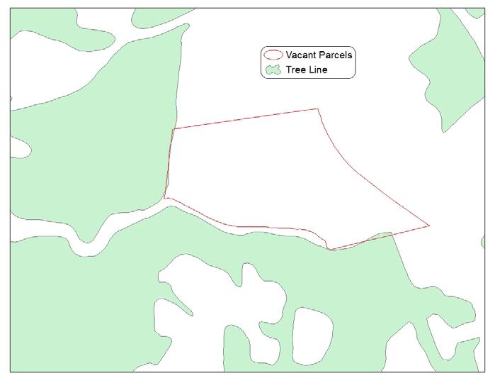
13 Problem A growing population within a finite area Push to develop empty or vacant parcels - any piece of property without a structure


14
15 Problem A growing population within a finite area Push to develop empty or vacant parcels - any piece of property without a structure - ~ 17% of City
16
17 Problem A growing population within a finite area Push to develop empty or vacant parcels - any piece of property without a structure - ~ 17% of City - Zoning irrelevant

18

19
20 Problem A growing population within a finite area Push to develop empty or vacant parcels - any piece of property without a structure - ~ 17% of City - Zoning irrelevant But... - many of larger, more desirable vacant parcels not zoned for high-end residential or business - developers requesting these parcels be rezoned

21 Problem Created a need for a tool that can help planners weigh conservation values of a vacant parcel when considering rezoning requests.
22 Problem Created a need for a tool that can help planners weigh conservation values of a vacant parcel when considering rezoning requests. City recognizes this need: Objective 4.B.9 of the Comprehensive Plan: Utilize GIS and other tools,..., to guide prioritization for conservation of current city open spaces and assessing impact of new development on surrounding natural systems.
23 Partnering with Local Government to Promote Sustainable Development 1 Background 2 Problem 3 Developing the Model 4 Results 5 Applications
24 Developing the Model Assess conservation value of vacant parcels
25 Choose Conservation Variables - Water - Wetland - Floodplain - Slope - Forest - Greenway - Park - Resource Conservation


26 Lynchburg

27 EPA concerned about TMDLs Virginia concerned about bacteria and nutrients Everyone concerned about stormwater runoff

28

29

30


31
32 Choose Conservation Variables - Water - Wetland - Floodplain - Slope - Forest - Greenway - Park - Resource Conservation Combine with Vacant Parcels GIS Criteria Threshold Values


33

34
35

36
37
38
39 Sum Variables Choose Conservation Variables - Water - Wetland - Floodplain - Slope - Forest - Greenway - Park - Resource Conservation Combine with Vacant Parcels GIS Criteria Threshold Values

40
41 Emphasize Variables as Desired Sum Variables Choose Conservation Variables - Water - Wetland - Floodplain - Slope - Forest - Greenway - Park - Resource Conservation Combine with Vacant Parcels GIS Criteria Threshold Values

42
43 Partnering with Local Government to Promote Sustainable Development 1 Background 2 Problem 3 Developing the Model 4 Results 5 Applications
44
45
46
47
48
49
50 Partnering with Local Government to Promote Sustainable Development 1 Background 2 Problem 3 Developing the Model 4 Results 5 Applications
51 Applications A. Make available to City Planning Commission - help evaluate rezoning requests B. Make available to general public

52

53
54 Applications A. Make available to City Planning Commission - help evaluate rezoning requests B. Make available to general public - useful for reducing applications i. Avoid requests for high conservation parcels ii. Increase value of low conservation parcels C. Classroom use


55

56
57 Applications Limitations/Problems 1. Challenge to keep current i. Update data layers ii. Redo analyses (students?) iii. Provide to City GIS/Online Viewer 2. Parcels assessed as whole entities
58
59 Applications Limitations/Problems 1. Challenge to keep current i. Update data layers ii. Redo analyses (students?) iii. Provide to City GIS/Online Viewer 2. Parcels assessed as whole entities 3. Use by developers?
60
61 Applications Limitations/Problems 1. Challenge to keep current i. Update data layers ii. Redo analyses (students?) iii. Provide to City GIS/Online Viewer 2. Parcels assessed as whole entities 3. Use by developers? Another tool in the full arsenal.
62 Applications Future Work Apply similar analysis to brownfields as opposed to vacant parcels.

63
64 Applications Future Work Apply similar analysis to brownfields as opposed to vacant parcels. - move towards redevelopment, not new development - consider financial and logistical criteria

65

66
67 Applications Coda Collaborations between academia and government agencies are often productive for both: - researchers can gain access to otherwise inaccessible data - governments can save time and money by having analyses conducted by others


68

69
The Flow. Green Infrastructure Taking Root in Cities 3/23/2015. Green Infrastructure Evolution City Plans/Projects Measureable and Holistic Benefits
 Green Infrastructure Taking Root in Cities Robert Hopper, P.E. CDM Smith The Flow Green Infrastructure Evolution City Plans/Projects Measureable and Holistic Benefits 2 1 Parts, Systems, Whole The first
Outfall Retrofit Feasibility Study
 Outfall Retrofit Feasibility Study 2013 APWA-NC SWM Conference September 16-17, 2013 Overview PWD history with outfall retrofits Project setting Review of screening factors and weighting scale QA/QC process
Green Infrastructure. NYS Department of Environmental Conservation
 Green Infrastructure Green infrastructure is an interconnected network of natural areas and open spaces that sustains ecosystems. Benedict, M.A. and E.T. McMahon. 2006. Green Infrastructure Linking Landscapes
Green Infrastructure Policies and Ordinances
 Green Infrastructure Policies and Ordinances October 23, 2013 By Karen Firehock, Green Infrastructure Center 2013 Georgia Urban Forest Council s 23 rd Annual Conference The mission of the nonprofit Green
TOWN OF BETHLEHEM OPEN SPACE CONSERVATION PLAN PUBLIC MEETING: OCTOBER 12, 2017
 TOWN OF BETHLEHEM OPEN SPACE CONSERVATION PLAN PUBLIC MEETING: OCTOBER 12, 2017 Welcome and Agenda 6:00 6:45: Open House, Part One 6:45 7:15: Presentation and Questions 7:15 8:00: Open House, Part Two
Swan Creek Urban BMP Inventory and Assessment. Jeff Grabarkiewicz, Kari Gerwin, Ann-Drea Hensley TMACOG, Lucas SWCD/Engineers, and Partners
 Swan Creek Urban BMP Inventory and Assessment Jeff Grabarkiewicz, Kari Gerwin, Ann-Drea Hensley TMACOG, Lucas SWCD/Engineers, and Partners Presentation Outline Project Background Methods Inventory Desktop
STORMWATER GREEN INFRASTRUCTURE AND PLANNING/ZONING BOARDS
 STORMWATER GREEN INFRASTRUCTURE AND PLANNING/ZONING BOARDS Source: Center for Watershed Protection, 2007 Southern Tier Central Regional Planning & Development Board Chemung County Stormwater Team OUTLINE
Working Group Meeting
 April 4,, 2017 Parks Operations Bldg Working Group Meeting Arts Districts Overview Stormwater/RPA/Stream Considerations First Principles Agenda 7:00pm 7:05pm 7:10pm 7:40pm 8:30pm 9:40pm 9:45pm Welcome
Citywide Integrated Stormwater Management Plan (ISMP) DRAFT ACTION PLAN REVIEW Public Consultation November 16 th, 2016
 DRAFT ACTION PLAN REVIEW Public Consultation November 16 th, 2016") Citywide Integrated Stormwater Management Plan (ISMP) DRAFT ACTION PLAN REVIEW Public Consultation November 16 th, 2016 1 Agenda DRAFT ACTION PLAN REVIEW Public Consultation Time 6:00 6:05 6:05 6:20 6:20
Citywide Integrated Stormwater Management Plan (ISMP) DRAFT ACTION PLAN REVIEW Public Consultation November 16 th, 2016 1 Agenda DRAFT ACTION PLAN REVIEW Public Consultation Time 6:00 6:05 6:05 6:20 6:20
Melissa Bernardo Hess, PE, CFM February 18, 2016
 Using Green Infrastructure in Your MS4 Community Melissa Bernardo Hess, PE, CFM February 18, 2016 Today s Discussion What is Green Infrastructure? Why should I consider Green Infrastructure? What practices
Des Plaines River Watershed: Opportunity Areas North Community Cluster 1:80,000. Miles. Public Parks or Preserve. Wetland Area
 Service Layer Credits: Harris Corp, Earthstar Geographics LLC Earthstar Geographics SIO 2015 Microsoft Corporation Des Plaines River Watershed: Opportunity Areas North Community Cluster SFR: Single Family
Green Infrastructure. by Karen Engel, NYS DEC. NYS Department of Environmental Conservation
 Green Infrastructure by Karen Engel, NYS DEC What is Green Infrastructure? For some it s all about water Green Infrastructure techniques use soils and vegetation to infiltrate, evapotranspirate, and/or
Camden SMART Initiative Stormwater Management and Resource Training
 Camden SMART Initiative Stormwater Management and Resource Training www.camdensmart.com Camden s Struggle with Stormwater 1 The City of Camden is served by a combined sewer system, which uses the same
Presentation Item C Annotated Model Outline for a Framework for a Green Infrastructure Plan
 Date: August 17, 2016 To: From: Subject: Management Committee Dan Cloak, Consultant Presentation Item C Annotated Model Outline for a Framework for a Green Infrastructure Plan Recommendation: Receive the
LANDSCAPE ARCHITECTURAL DESIGN: PROCESS, PREDILECTIONS, AND PRIORITIES
 LANDSCAPE ARCHITECTURAL DESIGN: PROCESS, PREDILECTIONS, AND PRIORITIES ECOLOGICAL DESIGN IN THE SOUTHEAST APRIL 23, 2014 DR. JON CALABRIA, ASLA ASSISTANT PROFESSOR, COLLEGE OF ENVIRONMENT AND DESIGN, UNIVERSITY
The Art and Science of Stormwater Retrofitting
 The Art and Science of Stormwater Retrofitting April 9, 2008 Michael Novotney, Center for Watershed Protection Deb Caraco, Center for Watershed Protection Dan Frisbee, City of Charlottesville, Virginia
National Association of Conservation Districts. Kris Hoellen Vice President, Sustainable Programs The Conservation Fund September 19, 2013
 National Association of Conservation Districts Kris Hoellen Vice President, Sustainable Programs The Conservation Fund September 19, 2013 Our Mission The Conservation Fund forges partnerships to conserve
Chapter 4 - Preparation of Stormwater Site Plans
 Chapter 4 - Preparation of Stormwater Site Plans The Stormwater Site Plan is the comprehensive report containing all of the technical information and analysis necessary for the City to evaluate a proposed
Riparian Buffer on the Bushkill Creek. Policies
 Riparian Buffer on the Bushkill Creek Riparian buffers provide numerous benefits to landowners and the community by protecting groundwater recharge areas, providing flood control, providing stormwater
SUN-B11-From Gray to Green; Revitalizing Milwaukee s Industrial Heart
 Session Title: Description: Learning Objectives: SUN-B11-From Gray to Green; Revitalizing Milwaukee s Industrial Heart Over the past 15 years the City of Milwaukee transformed the Menomonee Valley, Milwaukee's
GOING GREEN! NEWBURYPORT S PLAN FOR THE FUTURE
 GOING GREEN! NEWBURYPORT S PLAN FOR THE FUTURE Jennifer K. Lachmayr, PE, BCEE Kathryn B. Edwards, PE November 2015 Agenda Background Little River Flood Study Little River Pilot Program Vision for Implementation
Scorecard. WaterQuality. Appendix B USEPA WATER QUALITY SCORECARD APPENDIX B
 Appendix B USEPA WATER QUALITY SCORECARD EPA 231B09001 October 2009 http://www.epa.gov WaterQuality Scorecard Incorporating Green Infrastructure Practices at the Municipal, Neighborhood, and Site Scales
Westmoreland County Greenways Plan
 Westmoreland County Greenways Plan Citizens Advisory Board Review Draft April 2007 Prepared for: Westmoreland County and Smart Growth Partnership of Westmoreland County Prepared by: Environmental Planning
The Restoration of Reading Creek & Model Stream Buffer Ordinances/ Zoning Regulations for Alabama Streams
 The Restoration of Reading Creek & Model Stream Buffer Ordinances/ Zoning Regulations for Alabama Streams Charlene LeBleu, AICP, ASLA, Associate Professor of Landscape Architecture Auburn University Auburn,
Middle Mississippi River. Regional Corridor
 Middle Mississippi River St. Louis District Regional Corridor Lessons Learned from a Collaborative Planning Study Brian Johnson US Army Corps of Engineers 12 th Biennial Governor s Conference on the Management
Green Infrastructure Modeling in Cincinnati Ohio. Small Scale Green Infrastructure Design Using Computer Modeling
 Green Infrastructure Modeling in Cincinnati Ohio Small Scale Green Infrastructure Design Using Computer Modeling Presenters Jason Abbott is a Design Engineer with over 17 years of experience. Jason is
10.0 Open Space and Public Realm
 10.0 Open Space and Public Realm 10.0 Open Space and Public Realm The Public Open Space System is comprised of: outdoor spaces available for public use that are either publicly owned (e.g., parks and
Regional Economic Development Councils & The Consolidated Funding Application. Khris Dodson SU-EFC
 Regional Economic Development Councils & The Consolidated Funding Application Khris Dodson SU-EFC REDCs and You Each Region created a strategic plan. Strategic goals to improve economy: 1. Strengthen
LANDSCAPE VISUAL QUALITY ASSESSMENT IN WASHTENAW COUNTY, MI
 LANDSCAPE VISUAL QUALITY ASSESSMENT IN WASHTENAW COUNTY, MI Jiawei Huang Advisor: Oliver Kiley School of Natural Resources and Environment University of Michigan, Ann Arbor Visual Quality Visual Quality
Growing Sustainable Communities Conference
 Growing Sustainable Communities Conference M A N A G I N G S T O R M W A T E R W I T H G R E E N I N F R A S T R U C T U R E O C T O B E R 1 2, 2 0 1 1 Creating A Sustainable Development Code L A U R A
Southeast Michigan Council of Governments
 Southeast Michigan Council of Governments SEMCOG Green Infrastructure Activities Regional Green Infrastructure Vision GLRI Green Streets EPA Technical Assistance MDOT Grants Green Infrastructure Vision
What s Green Infrastructure?
 What s Green Infrastructure? Green infrastructure is strategically planned and managed networks of natural lands, working landscapes and other open spaces that conserve ecosystem values and functions and
Slow it, Spread it, Sink it using Green Stormwater Infrastructure
 Milly Archer Water Resources Coordinator Becky Tharp Green Infrastructure Collaborative Slow it, Spread it, Sink it using Green Stormwater Infrastructure Overview Defining LID and GSI Hydrology and impacts
Green Infrastructure Resources for Coastal Flood Risk Management
 Natural Floodplain Functions Alliance (NFFA) WEBINAR SERIES PRESENTS: Green Infrastructure Resources for Coastal Flood Risk Management Maria Honeycutt, PhD, CFM Lauren Long Tashya Allen NFFA Webinars Hosted
A BLUEPRINT FOR BROCKTON A CITY-WIDE COMPREHENSIVE PLAN
 A BLUEPRINT FOR BROCKTON A CITY-WIDE COMPREHENSIVE PLAN Public Meeting October 2016 1 Plan Summary and Discussion Public Meeting May 4 2017 City of Brockton Bill Carpenter, Mayor Department of Planning
Bristol Marsh Heritage Conservancy
 Bristol Marsh Heritage Conservancy The Pennsylvania Environmental Council (PEC) protects and restores the natural and built environments through innovation, collaboration, education and advocacy. PEC believes
NORTH CLAYMONT AREA MASTER PLAN COMMUNITY WORKSHOP #1 FEBRUARY 3, 2016
 NORTH CLAYMONT AREA MASTER PLAN COMMUNITY WORKSHOP #1 FEBRUARY 3, 2016 1. Introduction To the team and to the Plan Planning Partners The Claymont Community WILMAPCO New Castle County Claymont Renaissance
STEWARDSHIP OF LONG ISLAND SOUND S ECOLOGICAL AND RECREATIONAL RESOURCES
 STEWARDSHIP OF LONG ISLAND SOUND S ECOLOGICAL AND RECREATIONAL RESOURCES Robin Kriesberg, Save the Sound, Inc. Thomas Halavik, US Fish and Wildlife Service Coastal Program An Initiative to Identify, Protect
VACANT TO VIBRANT : GREEN INFRASTRUCTURE & URBAN REVITALIZATION
 VACANT TO VIBRANT : GREEN INFRASTRUCTURE & URBAN REVITALIZATION Calumet Summit 2013: Connecting for Action Lauren Riga, Director City of Gary Department of Green Urbanism Gary Storm Water Management District
TABLE OF CONTENTS. Transportation Chapter 1 - Introduction and Purpose of Planning to 1-3. Utilities
 Chapter 1 - Introduction and Purpose of Planning... 1-1 to 1-3 Pennsylvania Municipalities Planning Code (Act 247)...1-1 Previous County Planning Activities...1-1 Objectives of the Plan...1-2 Elements
VILLAGE BOARD MEETING STAFF REPORT
 Meeting: Village Board Meeting Date: 2/14/2011 Agenda Item: #5h Mission Statement We will provide residents and businesses quality services in a modern, courteous and efficient manner. VILLAGE BOARD MEETING
Minnesota Department of Natural Resource - Natural Resource Guidance Checklist Conserving Natural Resources through Density Bonuses
 Minnesota Department of Natural Resource - Natural Resource Guidance Checklist Conserving Natural Resources through Density Bonuses NRDB Why Use Density Bonuses & This Checklist Local units of government
RECREATION, OPEN SPACE AND GREENWAYS ELEMENT GOALS, OBJECTIVES, AND POLICIES
 RECREATION, OPEN SPACE AND GREENWAYS ELEMENT GOALS, OBJECTIVES, AND POLICIES GOAL R-1: DEVELOP A RECREATION, OPEN SPACE AND GREENWAYS SYSTEM AS AN INTEGRAL COMPONENT OF AN OVERALL, COUNTY-WIDE ECONOMIC
Brownfields and Urban Agriculture
 Brownfields and Urban Agriculture The Convergence of Land Recycling and Food Policy Joseph Schilling, Director Metropolitan Institute Virginia Tech, Alexandria Campus (Jms33@vt.edu) www.mi.vt.edu Mission:
2. Would the proposed project comply with the Land Use map? 3. Would the proposed project require a rezoning? 4. What is the proposed zoning district?
 TOWN OF CHAPEL HILL Planning and Sustainability Department 405 Martin Luther King Jr. Blvd. Chapel Hill, NC 27514 www.townofchapelhill.org phone (919) 9682728 Concept Plans are intended to be an opportunity
Integrating LEED ND & SITES Into Your Design Approach
 Integrating LEED ND & SITES Into Your Design Approach Joshua C. Sloan, RLA, ASLA, AICP, LEED AP ND, SITES AP Stephen K. Cook, RLA, ASLA, LEED AP O+M VIKA MD, LLC Planning Landscape Architecture Engineering
Silverdale Regional Center
 Silverdale Regional Center Vision for Silverdale Regional Center The Silverdale Regional Center Plan (Plan) will guide the evolution of the Silverdale Regional Center from a collection of strip malls and
495/MetroWest Development Compact Plan Citizen Planner Training Collaborative Conference. March 17, 2012
 495/MetroWest Development Compact Plan Citizen Planner Training Collaborative Conference March 17, 2012 Project Process Local and Regional Priority Areas Growth Scenarios Transportation Investment Categories
Developer s Program. The Station at East 54
 Developer s Program The Station at East 54 Existing Conditions The Station at East 54 is proposed for a 1.12 acre site at the northeast corner of Hamilton Road and Prestwick Road, tucked between the East
Board of Commissioners; Planning Board; George Wood, County Manager From: Randolph S. Williams, AICP, Principal Planner CC:
 Lincoln County Planning & Inspections Department Memo To: Board of Commissioners; Planning Board; George Wood, County Manager From: Randolph S. Williams, AICP, Principal Planner CC: Kelly Atkins, Director
EXISTING PLANS Harriet Festing Center for Neighborhood Technology Midlothian Community Meeting March 12, 2015
 EXISTING PLANS Harriet Festing Center for Neighborhood Technology Midlothian Community Meeting March 12, 2015 BENEFITS Bring economic, community + environmental benefits Enhance property values Use
5. Would the proposed project require modifications to the existing regulations?
 TOWN OF CHAPEL HILL Planning and Sustainability Department 405 Martin Luther King Jr. Blvd. Chapel Hill, NC 27514 www.townofchapelhill.org phone (919) 968-2728 Concept Plans are intended to be an opportunity
2. Would the proposed project comply with the Land Use map? 3. Would the proposed project require a rezoning? 4. What is the proposed zoning district?
 TOWN OF CHAPEL HILL Planning and Sustainability Department 405 Martin Luther King Jr. Blvd. Chapel Hill, NC 27514 www.townofchapelhill.org phone (919) 968 2728 Concept Plans are intended to be an opportunity
BROOKHILL NEIGHBORHOOD MODEL ZONING MAP AMENDMENT PREFACE TO APPLICATION
 BROOKHILL NEIGHBORHOOD MODEL ZONING MAP AMENDMENT PREFACE TO APPLICATION June 15, 2015 Revised: August 1, 2016 I. VISION Brookhill is a proposed community based upon the principles of Albemarle County
Hazard Mitigation Planning. Association of New Jersey Environmental Commissions Workshop Edison, New Jersey October 20, 2012
 Hazard Mitigation Planning Association of New Jersey Environmental Commissions Workshop Edison, New Jersey October 20, 2012 Mitigation Planning NJ Hazard Mitigation Plan? What is the status of the HMP
Problem Understanding
 Introduction...2-1 Previous Data and Mapping...2-2 Known Problem Areas...2-3 Resident Survey.2-3 Introduction The Village of Downers Grove stormwater system includes storm sewers, streams, wetlands, roadway
HISTORIC PRESERVATION PLAN
 Delaware County HISTORIC PRESERVATION PLAN Monday, June 20, 2016 Delaware County Planning Department Preservation Plan Today s Agenda Need for a Comprehensive Plan (including Preservation) Planning Process
Meeting Agenda. 1. Introductions (5 min)
") Meeting Agenda Monaca, PA Ohio River Brownfields Redevelopment Planning Federal/State/Regional Partners Meeting June 5, 2012; 3-4pm EDT Conference call-in #: 1-866-299-3188 Conference code: 202 566 0633#
Meeting Agenda Monaca, PA Ohio River Brownfields Redevelopment Planning Federal/State/Regional Partners Meeting June 5, 2012; 3-4pm EDT Conference call-in #: 1-866-299-3188 Conference code: 202 566 0633#
When planning stormwater management facilities, the following principles shall be applied where possible.
 2.0 Principles When planning stormwater management facilities, the following principles shall be applied where possible. 2.0.1 Drainage is a regional phenomenon that does not respect the boundaries between
IMPLEMENTING SOMERSET COUNTY S INVESTMENT FRAMEWORK
 IMPLEMENTING SOMERSET COUNTY S INVESTMENT FRAMEWORK SMART CONSERVATION THROUGH SMART GROWTH NJ LAND CONSERVATION RALLY March 22, 2014 Laurette Kratina, PP, AICP, Supervising Planner Somerset County Planning
Parks, Open Space and Trails
 Introduction Parks have often been referred as the lungs of our cities, cleansing the air of pollutants and particulate matter. Parks are also gathering places for families and community. They offer spaces
Miami Valley Regional Planning Commission Regional Land Use Planning
 Miami Valley Regional Planning Commission Regional Land Use Planning This document provides an overall approach on the region-based land use planning process, outlining the major tasks and work elements
{Best Practices. Summary of Tools, Strategies and Best Practices from 11 Michigan Case Study Communities
 Case Studies Michigan Coastal Community Working Waterfronts { Summary of Tools, Strategies and from 11 Michigan Case Study Communities Table of Contents Zoning...2 Community and Stakeholder Collaboration
Lilburn, GA STORMWATER BMP AND STREAM RESTORATION IN A CITY PARK. July 2013 Jill Stachura
 Lilburn, GA STORMWATER BMP AND STREAM RESTORATION IN A CITY PARK July 2013 Jill Stachura Project Location Gwinnett County, GA: Population: 825,000 Area: 437 sq. miles 1,300 miles storm drainage system
Rapid City Planning Commission Comprehensive Plan Amendment Project Report
 Rapid City Planning Commission Comprehensive Plan Amendment Project Report June 7, 2018 Applicant Request(s) Item #3 Case # 18CA001 Comprehensive Plan Amendment to change the future land use from Mixed-
REQUEST: Conditional Change of Zoning (AG-1, B-1,R-15 to Conditional R-7.5)
") REQUEST: Conditional Change of Zoning (AG-1, B-1,R-15 to Conditional R-7.5) 26 March 14, 2012 Public Hearing APPLICANT: KROLL ENTERPRISES, INC. PROPERTY OWNER: N&K PROPERTIES, LLC/B&W DEVELOPMENT LLC STAFF
REQUEST: Conditional Change of Zoning (AG-1, B-1,R-15 to Conditional R-7.5) 26 March 14, 2012 Public Hearing APPLICANT: KROLL ENTERPRISES, INC. PROPERTY OWNER: N&K PROPERTIES, LLC/B&W DEVELOPMENT LLC STAFF
Envision Sustainable Infrastructure
 Envision Sustainable Infrastructure Marshview Park Allyson Monsour, PE, ENV SP, LEED Green Associate What Is Sustainability? Social Sustainability Fair and beneficial labor practices Community involvement
LU Encourage schools, institutions, and other community facilities that serve rural residents to locate in neighboring cities and towns.
 Application No. 891627: Comprehensive Plan Text Amendment - Rural School Policies - Amend policies consistent with State Legislation allowing schools in the rural area and extension of sewer service to
Section 4 BUILDING THE MASTER PLAN
 The Master Plan 33 Section 4 BUILDING THE MASTER PLAN Figure 4:1. A collaborative effort characterized the two design workshops sponsored by DISC to create hypothetical Master Plans for the Towers Property
Florida Forever Conservation Needs Assessment Overview Maps
 Florida Forever Conservation Needs Assessment Overview Maps Prepared by Florida Natural Areas Inventory, The maps in this document are derived from the Florida Forever Conservation Needs Assessment, an
Downtown Stormwater Treatment:
 Downtown Stormwater Treatment: Suspended Pavement System Construction and Permitting Jennifer Buzun, P.E. City of Durham, Public Works Department Stormwater Services Andrew Jones, P.E. Kimley-Horn Redevelopment
Surrey Ecosystem Management Study
 Surrey Ecosystem Management Study Green Infrastructure Network Opportunities Public Open House & Information Session June 24 th, 2010 EMS Process Ecological Inventory Ecological Assessment Management Policy
From Policy to Reality
 From Policy to Reality Updated ^ Model Ordinances for Sustainable Development 2000 Environmental Quality Board 2008 Minnesota Pollution Control Agency Funded by a Minnesota Pollution Control Agency Sustainable
KAMPLAN City of Kamloops. Section D. Land Use Policies D-1
 KAMPLAN City of Kamloops Section D Land Use Policies D-1 City of Kamloops KAMPLAN D 1 Land Management and Development This section links to the following Community Values: D-2 develop complete neighbourhoods
Secrest Short Cut and Monroe Expressway Small Area Plan AUGUST 29, 2018
 Secrest Short Cut and Monroe Expressway Small Area Plan AUGUST 29, 2018 Background and Process Monroe Expressway will be open by the end of 2018 Union County and Indian Trail identified a need to revisit
PRELIMINARY STAFF PLANNING REPORT TO THE WALWORTH COUNTY ZONING AGENCY X CONDITIONAL USE
 This report was prepared prior to the public hearing. This report may be supplemented or amended to reflect the review of additional information presented at the public hearing and written material submitted
Weston s Wetlands, Stormwater, & Open Space
 Weston s Wetlands, Stormwater, & Open Space Weston s Wetlands, Stormwater, & Open Space Conservation Commission Role and Responsibilities Laws that protect wetlands What residents can do to protect wetlands
3.9 Systems Interrelationships
 191 Sustainability Building Blocks: The Comprehensive Plan Systems Community Form Economy Social Transportation Natural Resources Housing and Neighborhoods Utilities and Infrastructure Institutions.9 Systems
Conservation Corridor Planning and Green Infrastructure Themes
 Conservation Corridor Planning and Green Infrastructure Themes Prepared by the Green Infrastructure Center Inc. and the Northern Virginia Regional Commission February 22, 2011 Brief Overview Project Background
General Location Annex, Rezone & Preliminary Plat Lansdowne Addition, Unit Three
 NEWFOUNDLAND I-5 Agricultural District Subject Site SUNDANCE ANDERSON Single Family Residential CHRISTY PUD Agricultural District Highway Business General Location Annex, Rezone & Preliminary Plat Lansdowne
Jill Stachura STORMWATER BMP AND STREAM RESTORATION IN A CITY PARK. October 2013 Southeast Stormwater Association Annual Conference, Charlotte, NC
 Jill Stachura STORMWATER BMP AND STREAM RESTORATION IN A CITY PARK October 2013 Southeast Stormwater Association Annual Conference, Charlotte, NC Project Location Gwinnett County, GA: Population: 825,000
Planning for Staten. Habitat Restoration and Green Infrastructure. Island s North Shore
 Habitat Restoration and Green Infrastructure Planning for Staten Island s North Shore Community Board 1 March 1, 2018 NYC Parks Forestry, Horticulture, and Natural Resources Funded by the NYS Department
An evaluation of the reduced environmental impact from high density development
 An evaluation of the reduced environmental impact from high density development By Randel Lemoine Intuitively, it seems that a high-rise building will generate less rainwater runoff than a single-story
Prioritizing Vacant Urban Property for Green Infrastructure SG Final Report
 Prioritizing Vacant Urban Property for Green Infrastructure SG477-2014 Final Report Toledo Metropolitan Area Council of Governments February 2016 This project was funded through the Lake Erie Protection
BMP Siting Tool. Step-by-Step Guide
 BMP Siting Tool Step-by-Step Guide ArcGIS 10.1 Service Pack 1 (Build 3143) Prepared by: Tetra Tech, Inc. 10306 Eaton Place, Suite 340 Fairfax, VA 22030 January 2013 Contents 1 Getting Started... 1 1.1
Three threshold measures will be applied together to capture project scale and scope and impacts:
 The regulatory consequences to the County from State and Federal water quality regulations if the pollution impacts are not addressed by each project. The extreme difficulty, cost, and equity issues associated
Rebecca Dohn October 13, 2017
 Rebecca Dohn October 13, 2017 Why Green Infrastructure? Population Growth 46,000 45,000 44,000 43,000 42,000 41,000 40,000 39,000 38,000 37,000 36,000 Impervious Acres 2 Why Green Infrastructure? 3 Why
Let s Go to the Beach Evaluation and Modeling of a Coastal Community s Storm Drain System and Outfalls. Jeff Riling GHD November 2016
 Let s Go to the Beach Evaluation and Modeling of a Coastal Community s Storm Drain System and Outfalls Jeff Riling GHD November 2016 Acknowledgments City of Rehoboth Beach Mayor Sam Cooper Sharon Lynn
Community LID Workgroup Issue Paper #6
 Community LID Workgroup Issue Paper #6 Topic: Hard and Impervious Surface Coverage Limits Objective: Minimize the amount of hard and impervious surfaces in developments to allow more stormwater to infiltrate
Summary of Action Strategies
 Strategic Action Plan 6 Summary of Action Strategies Action Strategy Categories: 1. Organization and Management 2. Implementation 3. Marketing and Promotion This chapter summarizes all of the action strategies
Climate Smart Communities Green Infrastructure Case Studies
 New York State Water Resources Institute Climate Smart Communities Green Infrastructure Case Studies Emily Vail Hudson River Estuary Program NYS Department of Environmental Conservation Cornell University
March 14, Will Allen Director of Strategic Conservation Planning
 New Frontiers in Land Conservation: Green Infrastructure for Urban Vacant and Underutilized Lands 23 rd Annual RMLUI Conference March 14, 2014 Will Allen Director of Strategic Conservation Planning Special
RESILIENT COMMUNITIES PROJECT CITY OF MINNETONKA
 RESILIENT COMMUNITIES PROJECT CITY OF MINNETONKA BUILDING COMMUNITY-UNIVERSITY PARTNERSHIPS FOR SUSTAINABILITY Presentation to The League of Women Voters March 16, 2013 Julie Wischnack, Community Development
Gravel Roads and Parking
 Regulatory Update Gravel Roads and Parking Subject to Final Rule making Interim for programs implemented by local governments No mandate to modify existing ordinance New ordinances Gravel surfaces must
NEW GRANTS PROGRAM. Today I will describe what green infrastructure planning entails, how the model works and the importance of the work to planners!
 NEW GRANTS PROGRAM The South Carolina Forestry Commission received funds from the USDA Forest Service s Southern Region to build a green infrastructure landscape scale model and to fund several implementation
Environment and Natural Resources Trust Fund 2009 Phase 2 Request for Proposals (RFP)
") Environment and Natural Resources Trust Fund 2009 Phase 2 Request for Proposals (RFP) LCCMR ID: 023A1 Project Title: Olmsted County's Decorah Edge Total Project Budget: 103,380 Proposed Project Time Period
Environment and Natural Resources Trust Fund 2009 Phase 2 Request for Proposals (RFP) LCCMR ID: 023A1 Project Title: Olmsted County's Decorah Edge Total Project Budget: 103,380 Proposed Project Time Period
APPENDIX A SIMPLIFIED APPROACH TO STORMWATER MANAGEMENT FOR SMALL PROJECTS. In West Sadsbury Township, Chester County, Pennsylvania
 APPENDIX A SIMPLIFIED APPROACH TO STORMWATER MANAGEMENT FOR SMALL PROJECTS In West Sadsbury Township, Chester County, Pennsylvania TABLE OF CONTENTS I. Introduction 3 II. Importance of Stormwater Management
USF System Campus Master Plan Updates Goals, Objectives and Policies
 2015-2025 USF System Campus Master Plan Updates Goals, Objectives and Policies Tampa Goals, Objectives, and Policies Table of Contents Executive Summary 2015 2025 USF Campus Master Plan Update Introduction
TABLE OF CONTENTS PAGE
 1989 BROWARD COUNTY LAND USE PLAN Original adoption March 1, 1989 Text amendments adopted as of March 10, 2015, are incorporated herein. BROWARD COUNTY BOARD OF COUNTY COMMISSIONERS BROWARD COUNTY PLANNING
FUTURE LAND USE PLAN 7
 FUTURE LAND USE PLAN 7 The recommendations of each of the preceding chapters can be combined to present an overall Future Land Use Plan for Wilton. The Future Land Use Plan, presented on the following