Recreation and Parks Commission
|
|
|
- Francine Francis
- 6 years ago
- Views:
Transcription
1 Recreation and Parks Commission


2 PURPOSE OF TONIGHT S MEETING 1. Introduction And Overview Of the Memorial Park Neighborhood Plan 2. Precedents 3. Review And Discussion Of The Plan s Central Themes: A Sustainable Townscape A Linked Townscape A Local Townscape A Human-Scale Townscape A Balanced Townscape A Comprehensive View The Plan area s expanded boundaries allows for thorough consideration of all activities affecting this central light rail station. 2


3 THE LAND USE AND CIRCULATION ELEMENT Approved By The City Council After 6 Years Of Community Input Involving Thousands Of People Sets goals and policy for years Emphasizes neighborhood conservation and vehicle trip reduction Guides public/private projects in coordinated long-range planning Detailed planning in districts identified for managed growth; i.e. Activity Centers Adopted July 6, 2010 MPNP Bergamot Memorial Park Neighborhood Area Plan Focused Area Plan that will implement and replace the LUCE for this area. Downtown Preserves 96% of the City Reduces Amount of Land Area Available for Change 3


4 PLAN AREA MPNP IS NOT DESIGNING THE PARK 4


5 HISTORY - MEMORIAL PARK PLAN AREA From the Beginning - A Neighborhood Crossroads Early 1900 s Major railway juncture between Santa Monica and Downtown Los Angeles 1931 Garfield Elementary School is built; Closes in 1958 and is demolished in 1985 to build SMMUSD offices Santa Monica Municipal Stadium is operational Memorial Park opens Master Plan more industry adjacent to the future I-10 freeway. 1- and 2-story brick warehouses Sweet Dave s Surfboard shop. First foam core surfboards, used resin from Douglas Aircraft shop to perfect technique. Home to Tacos Por Favor beginning in Late 1960 s Memorial Park Gym is envisioned as a quality basketball facility for local teens 1993 PAL Youth Center opens Cove Skate Park is built. Garfield Elementary School (now SMMUSD) Photo Credit: QUINN RESEARCH CENTER Thelma Terry Speedway Sweet Daves Surfboards now Tacos Por Favor 2016 Expo Light Rail to begin passenger service 5


 (Photo courtesy of the")

6 HISTORY - MEMORIAL PARK Photo Credit: QUINN RESEARCH CENTER Photo Credit: QUINN RESEARCH CENTER Baseball, circa 1950 s, Memorial Park Little League Team Photo, Memorial Park The Cove, 2005 New Recreational Building (1950 s)14th/olympic 6 ABOVE: Santa Monica s first Little League team at Memorial Park (undated) (Photo courtesy of the Quinn Research Center); RIGHT: 1951 plaque to commemorate veterans


7 MEMORIAL PARK PLAN AREA TODAY Emerging From Industry Older, industrial building stock. one and two-stories. Variety of creative office, light industrial, auto service and limited retail. Lack of neighborhood environment few community amenities like restaurants or shops. Limited urban forest lack of canopy and shade, wildlife habitat, Memorial Park isolated from surrounds with no sense of natural connection. Local Restaurant Adaptive Reuse Creative Office SMMUSD 7


8 THE PURPOSE OF THE MPNP A Roadmap to Conserve District Character And Uses, Integrating Light Rail Service With Users, Guiding New Local Uses And Services Ensure benefits to the surrounding existing neighborhoods - Communicate priorities Provide connectivity to Expo station, manage roadways and parking, and support active transportation Encourage conservation and housing through incentives Emphasize sustainability: social, economic, cultural and infrastructural Introduce broader mix of land uses: compatible commercial, service, residential and light industrial Identify Infrastructure improvements open space, streets, pathways, improved freeway bridges, bicycle facilities, transit exchange areas An illustrative view envisioning the future Memorial Park neighborhood under proposed MPNP development design standards and objectives Neighborhood Uses During the MPNP Youth Workshop, residents asked for more affordable, healthy restaurants. 8
9 SUSTAINABILITY-DRIVEN MPNP SUPPORTED BY EPA GRANT Coordination with City Sustainability Policies Technical assistance for the MPNP provided by Santa Monica-based Global Green LEED for Neighborhood Development Analytics a rating system that recognizes projects that successfully protect and enhance the overall health, natural environment and quality of life. The rating system encourages best practices. Open Space Element Creative Capital Sustainable City Plan Sustainable Local Economy 9


10 OUTREACH Field Sports Advisory Council Landmarks Commission Taskforce on the Environment Recreation and Parks Commission Little League Board of Directors Pico Neighborhood Association Mid City Neighbors Police Activities League Boys and Girls Club Santa Monica Walks Santa Monica Spoke Chamber of Commerce SMMUSD St. John s Health Center Virginia Park Advisory Group VAP Parent Advisory Group City Departments SMC Transportation Task Force Local Business and Property Owners Community Outreach 10


11 OUTREACH A Wide Variety Of Topics Reviewed By The Community Open Space: Protect Memorial Park; Opportunities for green, breathable space as well as plazas and pathways Urban Form: scale, heights, setbacks Housing: affordable and workforce Parking: on-street and shared off-street facilities, park and ride, park spaces Community Facilities: PAL, CREST, Memorial Park Gym and Basketball Courts, new service providers Streets and Roads: Connectors, 17 th Street improvements, 16 th Street reconfiguration, boulevard character Community Outreach 11

12 Precedents


13 Memorial Park Santa Monica, CA


14 EXPO PHASE 2 IS UNDER CONSTRUCTION Completion in 2015 Operational in ,093 projected riders a day at Memorial Park Station by 2030! Regional transit service linking Santa Monica to Culver City, Downtown Los Angeles Expo Line Construction 14


15 Jesse Brewer Jr. Park Los Angeles, CA
16 Jesse Brewer Jr. Park Los Angeles, CA Amenities: barbecue pits, playground, restroom, benches, picnic areas Surrounding Uses: college campus, museum, gas station, community services Access: 4 main entry/exit points, transparent fencing, clear sight lines Ridership: 3,566 projected riders a day at Expo/Vermont station by 2030

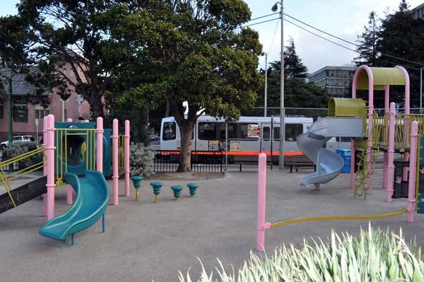

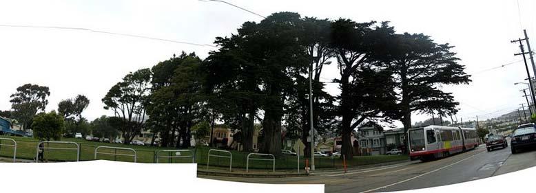
17 Duboce Park San Francisco, CA

18 Duboce Park San Francisco, CA Amenities: playground, basketball court, dog area, recreation center, restrooms Surrounding Uses: residential, medical center, localserving Access: transparent fencing, clear sight lines

19 Balboa Park San Francisco, CA

20 Balboa Park San Francisco, CA Amenities: 2 baseball diamonds, basketball court, soccer stadium, playground, 3 restrooms, 2 softball fields, swimming pool, skate park, 4 tennis courts Surrounding Uses: residential, freeway, community services, maintenance yard Access: 1 main entry/exit point, transparent fencing, clear sight lines


21 Cypress Street Park and Playground Brookline, MA
22 Cypress Street Park and Playground Brookline, MA Amenities: 2 baseball diamonds, basketball court, playground (no restroom) Surrounding Uses: residential, high school, arts building Access: 2 main entry/exit points, transparent fencing, clear sight lines


23 Lt. Joseph Petrosino Park Brooklyn, NY

24 Lt. Joseph Petrosino Park Brooklyn, NY Amenities: central play area, handball courts, playground, a wading pool, jungle gym Surrounding Uses: residential, neighborhood retail Access: 3 main entry/exit points, transparent fencing, controlled access


25 Union Park Chicago, IL
26 Union Park Chicago, IL Amenities: tennis courts, baseball fields, swimming pool, playground and athletic field for football or soccer, basketball courts Surrounding Uses: school, medical center, residential, industrial Access: transparent fencing, controlled access, clear sight lines
27 PRECEDENTS DESIGN CONSIDERATIONS 1. Visibility Park should be clearly visible from adjacent streets Street lights should be well spaced and in working order; alleys and parking areas should also be lit Fences should be transparent, allowing people to see in Plants should follow the 3-8 rule of thumb; hedges no higher than 3 feet and tree canopies starting no lower than 8 feet 2. Access Multiple entry and exit points should be provided Pathways should have clear sight lines 3. Maintenance Parks should be well maintained, removing litter and graffiti and replacing vandalized and burned out bulbs should be a priority 4. Surrounding Uses Parks should preferably be surrounded by active uses; windows that look out on streets are good natural surveillance
28 Central Themes Sustainable Linked Local Human- Scale Balanced


29 Central Themes 1. Introduction: A SUSTAINABLE TOWNSCAPE A Green, Sustainable Neighborhood Incorporation of adopted City documents providing guidance on open space, jobs, housing, culture, and environmental best practices Use of LEED-ND to refine and shape overall planning framework Achieving environmental excellence Local jobs and housing mix Emphasis on affordable and family housing for new projects MPNP LEED-ND Checklist (Completed June 2014) 29

30 Central Themes 2. Introduction: A LINKED TOWNSCAPE Multi-Modal Street Network to Improve Access and Health Designed to accommodate all modes and make the MPNP Area more walkable and bikeable. First and last mile connectivity to Expo Station to improve transit access and use Streets connectors to link the incomplete grid Widened sidewalks, bike facilities, and multi-use paths enhancing active transportation MPNP Circulation Network 30


31 A Linked Townscape ENHANCED CONNECTIONS Physical Street And Bicycle Infrastructure Improvements 17 th Street Bicycle Facility: Cycle track or buffered bike lanes 16 th Street Shared Street: Memorial Park loading and parking, Expo kiss and ride, shuttles New Connector Streets and Pathways to create walkable blocks, Expo access, small public spaces, landscaping, tree canopy and stormwater opportunities Intermodal Infrastructure at station area: mixing zone for transit riders, bikes and pedestrians Bus Routes, Stops and Layovers Pedestrian Connectors Future potential pedestrian connections between Olympic and Colorado could be facilitated through redevelopment. Bus Routes, Stops and Layovers Coordinating potential bus routes, stops and layovers with Big Blue Bus. 31


32 A Linked Townscape ENHANCED CONNECTIONS 17 th Street North/South Connection 17 th Street Bicycle Facility: Cycle track or buffered bike lanes 2 alternatives (ongoing study) 2 major segments : Pico/Colorado, Colorado/Wilshire Landscaping, stormwater infiltration Bridge improvements Connection to MANGo Key Map of 17 th St Cycletrack Cycletrack in Montreal Existing 17 th St North of Olympic Blvd 17 th Cycletrack Plan: Landscaping & Stormwater Infiltration, Bridge Improvements, Connection to MANGo 32


33 A Linked Townscape ENHANCED CONNECTIONS 16 th Street Shared Street 16 th Street: Expo kiss and ride, shuttles, Memorial Park loading and parking One-way, shared street with 16th/Olympic Access Park patron parking and staging area Improved sidewalks and crossing Shuttle drop-off and kiss-and-ride Day One Implementation 16 th Street Plan for Shared Street Drop Off, Kiss and Ride, Back in Angled Parking 33

 Ped/Bike")
34 A Linked Townscape ENHANCED CONNECTIONS Colorado/Olympic Connectors Reknit Grid with New Development New connector streets and pathways at 9 th, 10 th, 12 th and Euclid Streets to link to light rail, create improved circulation for all modes, walkable blocks, small public spaces, landscaping, tree canopy and storm water opportunities Vehicles Vehicles Ped/Bike Only Pedestrian/Bike Connection (50 width, minimum for Fire access & staging) Ped/Bike Only 34


35 A Linked Townscape ENHANCED CONNECTIONS Placemaking in the Streets Network of Public Realm Enhancements To Activate Streets and Make Existing Neighborhood More Walkable Wider sidewalks and possible regional bike path extension on Colorado Avenue Street trees, lighting and other pedestrian amenities on 17 th Street Landscaping requirements, opportunities for storm water capture Pedestrian and bike paseos Plazas and pocket parks intermittently distributed throughout area for rest, respite and greening Placemaking Opportunities 35


36 FREEWAY CAP FUTURE CONSIDERATIONS Possible future cross section of 17 th St Bridge Components of the Planning & Feasibility Study: Potential Funding Sources Design and Construction Issues Possible Phasing Options Engineering and Approval Processes Recommendations Proposed Next Steps

37 Central Themes 3. Introduction: A HUMAN-SCALE TOWNSCAPE Neighborhood Scale Design and Conservation of Existing Buildings and Uses Adaptive reuse, conservation emphasis Human-scale design of buildings and streets Compatible in-fill redevelopment Pedestrian-oriented land uses Translated into standards, such as. Incentives to encourage adaptive reuse of the buildings that give this area its character An adaptive reuse of an existing building retains the human scale of the existing industrial neighborhood Vernacular Street Wall low, without stepbacks Sidewalk widths: Transparency at Ground Floor 37 Proposed Colorado Avenue Setback Standards

38 Central Themes 4. Introduction: A LOCAL TOWNSCAPE Local-Serving Uses and Housing Neighborhood-oriented land uses Community facilities to serve local populations Housing diversity Neighborhood-oriented Expo Station Community Facilities Expanding community resources has been identified as an important goal for the MPNP to support local youth, job seekers and seniors. 38


39 Central Themes 5. Introduction: A BALANCED TOWNSCAPE Transit And Parking Resources Managed For Optimal Utilization Management of finite resources Coordination of Transit Services On-site Transportation Management Organization Short- and long-term parking solutions Context-based requirements Activity Center Transportation Management Example of screened parking Big Blue Bus on 14 th Street 39
 17th Street")
 Public interface with TMO")
40 A Linked Townscape MIXING VARIETY OF MODES AT EXPO STATION Critical crossroads for all modes at Expo 17 th Street/SMC Station Regional Expo Bike Path Terminus (with possible extension along Colorado) 17th Street bike facility Buses and Shuttles Pedestrians and transit riders Transit Transfer Plaza at 17 th Street Bike Center and bike share stations Station Amenities (restrooms, coffee, kiosk, etc) Public interface with TMO 40


41 A Balanced Townscape INTERIM & NEAR TERM SOLUTIONS Simplest and Most Cost-Effective Improvements First. On-street changes to pricing and hours. Additional spaces through street restriping Off-street changes to Memorial Park meters. Possible private partnerships Day One (and beyond) Roadway Improvements Colorado Avenue Expo Improvements 16th Shared Street (striping and one way) Grants for 17th Street bike and pedestrian facilities Light-Rail Readiness BBB Re-routing Bike Share at Station TMO-related transit programs Temporary Enhancements/Beautification at City-Owned Property Control Park parking to discourage long-term Expo Park and Riders Utilize free spaces on existing lots to serve employees 41
 is not compatible with district")


42 A Balanced Townscape INTER-AGENCY COLLABORATION Plan Recommendations for Park and Ride Lot Free parking (70) is not compatible with district parking strategy and other parking supply in the area Reimagine as Transit Transfer Plaza Flexible open space for vendors and events Bike racks for transit riders Pedestrian connection to transit Replace Park and Ride spaces within larger shared parking structure Transit Transfer Plaza A gateway for transit users, where bikes, pedestrians and buses converge Flexible Space Could be used for a variety of events and activities 42
43 Next Steps 43
44 Next Steps NEXT STEPS Meet with the Neighborhoods and Boards and Commissions Release DRAFT Memorial Park Neighborhood Plan for public review CEQA fall City Council adoption hearings 2015 This presentation will be available at
45 Thank You. Recreation and Parks Commission
Mid City Neighbors
 Mid City Neighbors 7.21.2014 www.memorialparkplan.net PURPOSE OF TONIGHT S MEETING 1. Introduction And Overview Of the Memorial Park Neighborhood Plan 2. Review of Outreach 3. Discussion Of The Plan s
Pico Neighborhood Association
 Pico Neighborhood Association 7.24.2014 www.memorialparkplan.net PURPOSE OF TONIGHT S MEETING 1. Introduction And Overview Of the Memorial Park Neighborhood Plan 2. Review of Outreach 3. Discussion Of
Draft Bergamot Area Plan
 ATTACHMENT 1 Draft Bergamot Area Plan Taskforce on the Environment April 15, 2013 www.bergamotplan.net 1 Overview WHAT IS THE BERGAMOT AREA PLAN? A Community-Based Planning Document Guiding the Future
THE GREEN VISION WORKSHOP Friday, November 6, 2009
 THE GREEN VISION WORKSHOP Friday, November 6, 2009 SUSTAINABLE LONG RANGE PLANNING IN SANTA MONICA Eileen Fogarty Director, Planning and Community Development GREEN BUILDINGS Santa Monica has the most
The Lincoln Neighborhood Corridor Plan. The LiNC
 October 1, 2014 Planning Commission Study Session The Lincoln Neighborhood Corridor Plan The LiNC Purpose of Tonight s Meeting Introduction to The LiNC Review of Existing Conditions and Community Identified
The University District envisions, in its neighborhood
 Envisioning the University District Link Light Rail in Seattle s neighborhoods CIY OF SEALE CONCEP-LEVEL SAION AREA PLANNING RECOMMENDAION RESOLUION # 30165 EXHIBI L Vision 08.2000 he University District
Transportation. Strategies for Action
 Transportation A major priority for the Overlake Neighborhood is to develop a multimodal transportation system. To achieve this system, a balance has to be found among travel, circulation and access needs;
Port Credit Local Advisory Panel October 20 th Meeting
 Port Credit Local Advisory Panel October 20 th Meeting Focus Of This Evening s Meeting: 1. Hurontario Main Street Higher Order Transit Study 2. Port Credit Mobility Hub & GO Station Parking Structure Study
Gold Line Bus Rapid Transit Transit Oriented Development (BRTOD) Helmo Station Area Plan
 Helmo Station Area Plan") Appendix F Gold Line Bus Rapid Transit Transit Oriented Development (BRTOD) Helmo Station Area Plan Introduction and Purpose of the Plan The Gold Line Bus Rapid Transit facility is an eleven-mile dedicated
Appendix F Gold Line Bus Rapid Transit Transit Oriented Development (BRTOD) Helmo Station Area Plan Introduction and Purpose of the Plan The Gold Line Bus Rapid Transit facility is an eleven-mile dedicated
CITY OF CHARLOTTESVILLE, VIRGINIA CITY COUNCIL AGENDA
 CITY OF CHARLOTTESVILLE, VIRGINIA CITY COUNCIL AGENDA Agenda Date: December 16, 2013 Action Required: Adoption of Resolution Presenter: Staff Contacts: Title: James E. Tolbert, AICP, Director of NDS James
CAL POLY MASTER PLAN UPDATE, March 2015
 Some Key Themes in the General Guiding Principles Academic Mission The plan must foremost advance the University s academic mission and student success. Foresight and Adaptability The plan should take
CHAPTER 1. Ms. Guajardo s Class - Central Elementary CH 1 1
 INTRODUCTION CHAPTER 1 Ms. Guajardo s Class - Central Elementary CH 1 1 1.1 SETTING South Centre City is a linear corridor south of Downtown Escondido paralleling Centre City Parkway and South Escondido
RESEDA - WEST VAN NUYS COMMUNITY PLAN
 RESEDA - WEST VAN NUYS COMMUNITY PLAN Executive Summary As part of the initial outreach effort, the Department of City Planning hosted two workshops for the Reseda-West Van Nuys Community Plan Area during
University of the District of Columbia Van Ness Campus Master Plan Community Open House 3. December 8, 2010
 University of the District of Columbia Van Ness Campus Master Plan Open House 3 December 8, 2010 Introductions Sequence of Work: Campus Master Plan BEGIN: INTRODUCE AND START WORK Project Initiation Team
CENTRAL ESTUARY PLAN AVISION FOR OAKLAND S WATERFRONT
 Central Estuary Plan A VISION FOR OAKLAND S WATERFRONT Specific Plan and Environmental Assessment Presentation to the Parks and Recreation Advisory Commission December 9, 2009 This Afternoon s Presentation
Concord Community Reuse Project Goals and Guiding Principles. Overarching Goals (OG)
") Concord Community Reuse Project Goals and Guiding Principles Overarching Goals (OG) No priority is implied by the order of presentation of the goals and guiding principles. Overarching goals for the Concord
Concord Community Reuse Project Goals and Guiding Principles Overarching Goals (OG) No priority is implied by the order of presentation of the goals and guiding principles. Overarching goals for the Concord
Neighborhood Districts
 NEIGHBORHOOD DISTRICTS SEVEN MAIN DISTRICTS Neighborhood Districts While the Development Plan provides a broad-scale overview of the neighborhood, this section focuses on uses and relationships at the
THE 355/270 CORRIDOR:
 THE 355/270 CORRIDOR: Strategic Ideas for Sustaining a Livable Work Place Project Summary ACCESS LIFE DESIGN HEALTH WORK Montgomery County Planning Department The Maryland-National Capital Park and Planning
CHAPTER 7: Transportation, Mobility and Circulation
 AGLE AREA COMMUNITY Plan CHAPTER 7 CHAPTER 7: Transportation, Mobility and Circulation Transportation, Mobility and Circulation The purpose of the Transportation, Mobility and Circulation Chapter is to
4 C OMMUNITY D ISTRICTS
 4 C OMMUNITY D ISTRICTS N ew development in the Area will include many different types of land uses, including a destination retail area that attracts people from all over the region; recreation opportunities
PLAN ELEMENTS WORKSHOP. April 5, 2016
 PLAN ELEMENTS WORKSHOP April 5, 2016 needs more housing. But there is no one-size fits-all solution. Every neighborhood has its own character. In some places, density is not only appropriate it is badly
City of Santa Monica Memorial Park Neighborhood Plan Workshop #2: Options and Ideas Civic Center, East Wing Thursday, January 16, :30-9:30PM
 City of Santa Monica Memorial Park Neighborhood Plan Workshop #2: Options and Ideas Civic Center, East Wing Thursday, January 16, 2014 6:30-9:30PM Summary The planning process for the Memorial Park Neighborhood
City of Los Angeles Department of Public Works
 City of Los Angeles Department of Public Works Environmental Scoping Meeting for the Proposed Sixth Street Park, Arts, River & Connectivity Improvements (PARC) Project May 3, 2017 1 Agenda Introductions
DRAFT Land Use Chapter
 Stevens Creek Urban Village DRAFT 1 18 17 Land Use Chapter INTRODUCTION This Land Use Chapter describes how the Stevens Creek Urban Village will accommodate the growth that is planned for it in the Envision
EXPO LINE COMMUNITY WORKSHOPS NOVEMBER 27 TH & DECEMBER 3 RD Los Angeles Department of City Planning
 EXPO LINE COMMUNITY WORKSHOPS NOVEMBER 27 TH & DECEMBER 3 RD 2012 Los Angeles Department of City Planning Agenda for Tonight Open House 6:00 to 6:15pm Presentation and Questions 6:15 to 6:50 Small Group
MURRAY CENTRAL STATION MASTER PLAN Central Station Area of Influence and Site Analysis
 CENTRAL STATION MASTER PLAN Central Station Area of Influence and Site Analysis OVERVIEW Planned Fire Station TAYLORSVILLE A thorough Site Analysis was conducted to ensure planning and design concepts
Design Alternatives Workshop. Hilfiker Park Master Plan Workshop #2
 Design Alternatives Workshop Hilfiker Park Master Plan Workshop #2 Agenda for Tonight Staff Presentation (40 min) Introduction Master Plan Process Planning Context What We ve Heard So Far Design Alternatives
City of Hermosa Beach Administrative Policy #
 City of Hermosa Beach Administrative Policy # SUBJECT: Living Streets Policy Date: Approved by: City Council Authority: Public Works Department & Community Development Department Mayor, PURPOSE The City
EXISTING COMPREHENSIVE PLAN
 EXISTING COMPREHENSIVE PLAN Town Center Land Use Element: V. LAND USE POLICIES Town Center Mercer Island's business district vision as described in "Your Mercer Island Citizen-Designed Downtown" was an
A BLUEPRINT FOR BROCKTON A CITY-WIDE COMPREHENSIVE PLAN
 A BLUEPRINT FOR BROCKTON A CITY-WIDE COMPREHENSIVE PLAN Public Meeting October 2016 1 Plan Summary and Discussion Public Meeting May 4 2017 City of Brockton Bill Carpenter, Mayor Department of Planning
DRAFT ROOSEVELT ROAD. District Recommendations. Figure 5.23 The Roosevelt Road Corridor
 CHAPTER 5 Figure 5.23 The Road Corridor Road will develop as a mixed-use corridor, emphasizing regional retail, west of the river and mixed-use development east of the river. KEY RECOMMENDATIONS 1. High
DALY CITY VISIONING PROCESS COMMUNITY WORKSHOP 3 MAY 8, 2008
 DALY CITY VISIONING PROCESS COMMUNITY WORKSHOP 3 MAY 8, 2008 PROCESS General Plan - a statement of the community s values, vision and aspirations for now and into the future... Timeframe LONG TERM - 2030
AvalonBay Communities + BRIDGE Housing. Mission Housing Habitat for Humanity Pacific Union Development Corporation
 AvalonBay Communities + BRIDGE Housing Mission Housing Habitat for Humanity Pacific Union Development Corporation Tonight s Agenda Recap of discussion from last CAC meeting Updates on meetings with Stakeholders
Study Area. Capitol Way. Greening America s Capitals 11/13/2014. A Greening America s Capitals Project
 Olympia, WA: Greening Capitol Way Supporting Communities move towards sustainability is a priority for the federal government. A Greening America s Capitals Project Office of Sustainable Communities U.S.
Robbinsdale LRT Station. CDI Development Guidelines. August Overview
 Robbinsdale LRT Station August 2018 Overview The City of Robbinsdale may have the coolest opportunity site along the 13 mile stretch of the Bottineau LRT corridor / Blue Line extension. Located a block
Chapter 1.0 Introduction
 Chapter 1.0 Introduction 1.1 Background The North Metro commuter rail line is part of the RTD FasTracks regional transit system expansion program to build more than 100 miles of rail transit throughout
Public may provide comments on the GDP within the next two weeks (December 24)
") 25/70 General Development Plan (GDP) Public Meeting Wednesday, December 10, 2014 6:00 8:00 P.M. District 1 Police Station Community Room 1311 W 46th Ave, Denver, CO 80211 Council Woman Montero: This particular
25/70 General Development Plan (GDP) Public Meeting Wednesday, December 10, 2014 6:00 8:00 P.M. District 1 Police Station Community Room 1311 W 46th Ave, Denver, CO 80211 Council Woman Montero: This particular
Chapter 1: Introduction
 Chapter 1: Introduction The Penn Avenue Community Works Corridor Vision and Implementation Framework presents an integrated communitybased vision and a coordinated, long-term implementation framework for
Town Center (part of the Comprehensive Plan)
") Town Center (part of the Comprehensive Plan) Mercer Island Town Center Looking North (2014) In 1994, a year-long process culminated in a set of design guidelines and code requirements for the Town Center
Town Center (part of the Comprehensive Plan) Mercer Island Town Center Looking North (2014) In 1994, a year-long process culminated in a set of design guidelines and code requirements for the Town Center
City Council March 27, Parks, Recreation, and Trails Master Plan
 City Council March 27, 2018 Parks, Recreation, and Trails Master Plan Planning Process Develop Goals and Objectives Inventory of Areas and Facilities Needs Assessment And Identification Public Participation
Policies and Code Intent Sections Related to Town Center
 Policies and Code Intent Sections Related to Town Center The Town Center Vision is scattered throughout the Comprehensive Plan, development code and the 1994 Town Center Plan. What follows are sections
International Blvd. TOD Plan Public Workshop #1
 International Blvd. TOD Plan Public Workshop #1 Add photos or project images September 21 and 22, 2010 Workshop Purpose Introduce the public to the Project Review and discuss the existing conditions analysis
Master Plan Presentation August 12, 2015
 Master Plan Presentation August 12, 2015 A vision for tomorrow... May, 13 2015 prepared for: prepared by: SITE LOCATION SITE NTS SITE ANALYSIS +/- 17.8 Ac. RESIDENTIAL HOMES 1 2 RAIL ROAD (SAFETY CONCERNS)
Implementation Guide Comprehensive Plan City of Allen
 Implementation Guide 2030 Comprehensive Plan City of Allen DRAFT 2015 Implementation Guide Allen 2030 Comprehensive Plan INTRODUCTION The Comprehensive Plan serves as a guide for the growth and development
Rezoning Issues Setting a Foundation for Zoning Decisions
 Rezoning Issues Setting a Foundation for Zoning Decisions City Council Workshop May 2, 2016 Agenda Goal Need actionable items and sequence of steps Foundation for Zoning Decisions Council Workshop Discussion
Planning Commission Report
 Planning Commission Report To: From: Subject: Planning Commission Meeting: January 6, 2016 Agenda Item: 8-B Planning Commission David Martin, Planning & Community Development Director Introduction to the
SOUTHEAST SPORTS COMPLEX MASTER PLAN
 REPORT TO SOUTHGATE NEIGHBORHOOD COUNCIL APRIL 13, 2016 Visioning Process April 30: Stakeholder Meeting with Sports Groups May 5: Stakeholder Meeting with Southgate Land Use Committee May 13: SNC Meeting
38 Queen s University Campus Master Plan Part 1
 38 Queen s University Campus Master Plan Part 1 46 The Campus at the City Scale Chapter 4 The Campus at the City Scale 39 Queen s is an urban University centrally located in Kingston. Decisions made by
THE NEIGHBORHOOD TODAY
 THE NEIGHBORHOOD TODAY CORE AREA VISION How are we Good Urbanism A Site s DNA thinking about Elements of great Unique elements urban communities embedded in a place the site and design? ELEMENTS LIKE:
TRANSIT-ORIENTED DEVELOPMENT POLICY DRAFT. City Planning and Development Department Kansas City, Missouri
 TRANSIT-ORIENTED DEVELOPMENT POLICY DRAFT City Planning and Development Department Kansas City, Missouri What is Transit Oriented Development (TOD)? Development that focuses land uses around a transit
Northwest Rail Corridor and US 36 BRT Development Oriented Transit Analysis 4.4 STATION AREA FINDINGS
 4.4 STATION AREA FINDINGS Each station is different, and each one requires a separate set of recommendations based on the vision for the site. This section outlines an initial TOD strategy and recommendations
Metro 2010 Pedestrian Symposium Walking into the Future City
 Metro 2010 Pedestrian Symposium Walking into the Future City John Kaliski, AIA, May 12, 2010 How can our transportation and land use policies create complete streets for all users? How do we optimize the
LEED-ND 101: Practical Strategies for Achieving Sustainability Goals. Travis Parker Lakewood Planning Director
 LEED-ND 101: Practical Strategies for Achieving Sustainability Goals Travis Parker Lakewood Planning Director Metro Vision Idea Exchange Oct 11, 2012 West Corridor Stations West Corridor Overview West
Appendix E Section 4(f) Evaluation
 Evaluation") Appendix E Section 4(f) Evaluation Appendix E Draft Section 4(f) Evaluation E.1 Introduction This appendix addresses a federal regulation known as Section 4(f), which protects parks, recreation areas,
Appendix E Section 4(f) Evaluation Appendix E Draft Section 4(f) Evaluation E.1 Introduction This appendix addresses a federal regulation known as Section 4(f), which protects parks, recreation areas,
ROBBINSDALE LRT STATION CDI DEVELOPMENT GUIDELINES
 August 2018 OVERVIEW The City of Robbinsdale has a prime-opportunity site in the middle of the 13 mile stretch of the Bottineau LRT corridor / Blue Line extension. Robbinsdale offers a prominent, vital,
Preliminary Recommendations Tk Takoma/Langley Crossroads Sector Plan
 Preliminary Recommendations Tk Takoma/Langley Crossroads Sector Plan Vision is to achieve a Transit Oriented, pedestrian friendly Community that Celebrates and builds upon the cultural Diversity of the
TRANSIT NEIGHBORHOOD PLANS PROGRAM OVERVIEW
 TRANSIT NEIGHBORHOOD PLANS PROGRAM OVERVIEW OCTOBER 2017 Los Angeles Department of City Planning @LATNP and @Planning4LA Outline Introduction Policy Framework The Transit Neighborhood Plans Program Overview:
PLAN ON A PAGE SUMMARY
 Questions? Please Call - 423-989-5518. PLAN ON A PAGE SUMMARY The Plan on a Page is a tool for the City of Bristol to engage Bristol s neighborhoods, community organizations, and interest groups to organize
City of Nogales General Plan
 Open Space, Parks, Recreation and Trails City of Nogales General Plan Residents of Nogales place a high priority in the development of a comprehensive system of open space, parks, recreation and trails
NAS-JRB Willow Grove Base Reuse Master Plan and Implementation Strategy
 NAS-JRB Willow Grove Base Reuse Master Plan and Implementation Strategy Community Planning Charrette Horsham Township, PA June 10-11, 2011 COMMUNITY DESIGN CHARRETTE Agenda 1. Review of Community Charrette
Urban Design Manual PLANNING AROUND RAPID TRANSIT STATIONS (PARTS) Introduction. Station Study Areas
 Introduction. Station Study Areas") 111111 PLANNING AROUND RAPID TRANSIT STATIONS (PARTS) Introduction The ION rapid transit system will link Waterloo, Kitchener and Cambridge through a central transit corridor (CTC). There are a number
111111 PLANNING AROUND RAPID TRANSIT STATIONS (PARTS) Introduction The ION rapid transit system will link Waterloo, Kitchener and Cambridge through a central transit corridor (CTC). There are a number
Public Meeting May 20, 2014
 Public Meeting May 20, 2014 Overview Study Purpose Study Area Overview Strategies Potential Opportunities Implementation and Discussion Skeo Solutions Raleigh Walkable Watershed Pilot 2 Purpose Develop
Promoting Economic Development Through Upfront SEPA Review: Lessons from South Downtown Tacoma
 Promoting Economic Development Through Upfront SEPA Review: Lessons from South Downtown Tacoma 1 This session will focus on the City of Tacoma s South Downtown Subarea Plan and associated Non-Project SEPA
SAFETY AND CONNECTIVITY IN A PLANNED COMMUNITY
 DALE CITY TLC SAFETY AND CONNECTIVITY IN A PLANNED COMMUNITY PROJECT KICKOFF MEETING MARCH 7, 2016 AGENDA 1. Introductions 2. Project Overview 3. Discussion 4. Site Visit PROJECT KICKOFF MEETING MARCH
Isabel Neighborhood Plan: Alternatives
 Isabel Neighborhood Plan: Alternatives Presented by: Lori Parks, Associate Planner February 2, 2015 Agenda 1. Background on BART to Livermore 2. Isabel Neighborhood Plan 3. Alternative Scenarios 4. General
Pedestrian and Bike Bridge LOGO
 6.2.2 Pedestrian and Bike Bridge The proposed pedestrian and bike crossing re-envisions the existing bridge at Pismo Creek on Cypress Street. The bridge is currently underutilized by vehicular through
REGIONAL ACTIVITY CENTER
 DRAFT REGIONAL ACTIVITY CENTER 70 EAST BENCH MASTER PLAN DRAFT 06 Introduction The East Bench Regional Activity center is comprised of large educational, research, medical, and employment centers. These
Table L-1 Summary Action Strategy. Action Item Timing Status Responsible Agency
 CHAPTER 4: CIRCULATION ELEMENT ISSUE #1: MAJOR THOROUFARES AND TRANSPORTATION ROUTES A balanced transportation system for Fontana is provided that meets the mobility needs of current and future residents
Planning Board Briefing
 Planning Board Briefing Why Now? The Sector Plan Implementation Chapter States: Before Stage 1 begins, the following must occur: Approval of the Sectional Map Amendment. Approval of the Greater Lyttonsville
A larger version of this map is located on the last page of this PDF.
 MAP Committee Input McLoughlin Area Draft Vision Map A larger version of this map is located on the last page of this PDF. 1. The map above is intended to portray a vision for the McLoughlin area. It highlights
Silverdale Regional Center
 Silverdale Regional Center Vision for Silverdale Regional Center The Silverdale Regional Center Plan (Plan) will guide the evolution of the Silverdale Regional Center from a collection of strip malls and
April 21, 2007 CCRP Workshop Summary
 April 21, 2007 CCRP Workshop Summary Group 1 1. Reuse around BART with a lot of housing and jobs 2. Greenway around creek 3. Transit and auto connection all through the site from Kirker Pass to Port Chicago
REDLANDS TRANSIT VILLAGES SPECIFIC PLAN
 REDLANDS TRANSIT VILLAGES SPECIFIC PLAN CITY COUNCIL STUDY SESSION JANUARY 4, 2019 Redlands Blvd. Eureka St. Orange St. State St. Citrus Ave. Vine St. GENERAL PLAN TRANSIT VILLAGES WE ARE HERE SPECIFIC
DRAFT Civic Center Station Area Plan. Executive Summary
 DRAFT Civic Center Station Area Plan Executive Summary This project is funded in part through the Metropolitan Transportation Commission s Station Area Planning Program. The preparation of this report
SFMTA PHELAN LOOP AND PUBLIC PLAZA PHELAN OCEAN AVENUE
 SFMTA Municipal Transportation Agency Image: a bus in front of the Palace of the Legion of honor SFMTA PHELAN LOOP AND PUBLIC PLAZA PHELAN AVENUE @ OCEAN AVENUE Community Meeting May 23, 2012 San Francisco,
FUNDING CORRIDOR REVITALIZATION
 FUNDING CORRIDOR REVITALIZATION Integrated corridor planning for the 21 st Century America Planning Association Annual Conference Atlanta, GA April 27, 2014 Mariia Zimmerman, MZ Strategies, LLC mariia@mzstrategies.com
TOWN COUNCIL / PLANNING COMMISSION
 Workshop #3 TOWN COUNCIL / PLANNING COMMISSION January 20, 2011 Consultant Team In Attendance Tonight BMS Design Group Nevada City and San Francisco Michael Smiley, AICP, ASLA Partner-in-Charge Nancy L.
DRAFT. October Wheaton. Design Guidelines
 October 2011 DRAFT Wheaton Design Guidelines 2 Draft - Design Guidelines - Wheaton Sector Plan Contents 04 Section 1: Introduction 06 Section 2: Context 08 Section 3: Design Guidelines 09 Goal 1: Create
ARLINGTON COUNTY, VIRGINIA. County Board Agenda Item Meeting of April 21, 2018 SUPPLEMENTAL REPORT
 ARLINGTON COUNTY, VIRGINIA County Board Agenda Item Meeting of April 21, 2018 SUPPLEMENTAL REPORT DATE: April 18, 2018 SUBJECT: Request to authorize advertisement of public hearings by the Planning Commission
Sahuarita District & Phase 1 Master Plan. Town Council December 11, 2017
 Sahuarita District & Phase 1 Master Plan Town Council December 11, 2017 Visioning Study Visioning Process Advisory Group Meetings Community Questionnaire Town Center Case Studies Community Analysis The
Attachment B Summary of Plan Alternatives Report
 Attachment B Summary of Plan Alternatives Report Based on community ideas and feedback to date, a series of draft alternative scenarios for the future of downtown s neighborhood districts have been created
Plano Tomorrow Vision and Policies
 Plano Tomorrow Vision and Policies PLANO TOMORROW PILLARS The Built Environment The Social Environment The Natural Environment The Economic Environment Land Use and Urban Design Transportation Housing
greenprint midtown SUSTAINABILITY ACTION PLAN 2012
 greenprint midtown SUSTAINABILITY ACTION PLAN 2012 MIDTOWN ALLIANCE SOUTHFACE ENERGY INSTITUTE RENAISSANCE PLANNING GROUP SUSTAINABLE ATLANTA PERKINS+WILL 2 GREENPRINT MIDTOWN 1. Introduction Sustainability
Economy Vision Statements: Social Wellbeing Vision Statements: Natural Environment Vision Statements:
 Economy Vision Statements: 1. Our business environment makes us a region of choice for new employers as we encourage entrepreneurship and have a vibrant, diversified and resilient regional economy. 2.
 Community Workshop #2 December 4, 2014 Team Tonight s Agenda 6:00 pm Welcome! 6:05 pm The Future of Downtown Tustin Ideas, Strategies and Recommendations 6:35 pm Questions and Comments 6:50 pm Open
FOUR MILE RUN VALLEY WORKING GROUP AND CHARGE
 FOUR MILE RUN VALLEY WORKING GROUP AND CHARGE Adopted April 16, 2016 Amended July 19, 2016 Overview of Integrated Effort The overall goal of the Four Mile Run Valley (4MRV) initiative is to develop a comprehensive
Courthouse Planning Area
 Courthouse Planning Area Current Reality The Courthouse Planning Area is the characterized by expansive suburbanscale residential areas as well as the community resource planned area of athletic, educational,
Corridor-Level Approaches to Creating Transit-Oriented Districts
 Corridor-Level Approaches to Creating Transit-Oriented Districts Dena Belzer Strategic Economics and Center for Transit-Oriented Development August 2011 5-year old partnership dedicated to improving practice
chapter DESIGN GUIDELINES NEW RIVER MASTER PLAN REPORT
 chapter DESIGN GUIDELINES NEW RIVER MASTER PLAN REPORT .76 DESIGN GUIDELINES An Overview design guidelines NEW RIVER MASTER PLAN Design Guidelines can transform the image of a city. Specific, design-based
Chapter 4. Linking Land Use with Transportation. Chapter 4
 Chapter 4 Linking Land Use with Transportation Chapter 4 59 Chapter 4 Linking Land Use with Transportation Community Design and Transportation Program Introduction Since the 1950s, the predominant development
Metro. Activity Center Design Guidelines. Recommendations For Developing Focused, Mixed-Use Commercial/Residential Centers
 Metro Activity Center Design Guidelines Recommendations For Developing Focused, Mixed-Use Commercial/Residential Centers Metro Activity Centers What is a MAC? Legacy, the adopted guide for the future growth
TOD 101 CREATING LIVABLE COMMUNITIES WITH TRANSIT
 1 CREATING LIVABLE COMMUNITIES WITH TRANSIT What are transit Centered Communities? Benefits of Partnerships to Support and Implement What You Will Learn Portland s Pearl District Your Trainers Today Catherine
RECREATION AND OPEN SPACE ELEMENT
 RECREATION AND OPEN SPACE ELEMENT Last amended August 19, 2008 Table of Contents Objective Page 5.1 Park system defined... 5-1 5.2 Access to parks and recreational facilities... 5-2 5.3 Recreation and
ITEM #8. Regional Smart Growth Program. Regional Smart Growth Program. Presentation Overview. Coast Highway Vision and Stategic Plan.
 Regional Smart Growth Program Economic Development Commission What is Smart Growth? Adopted as part of the Regional Comprehensive Plan (RCP) RCP provides vision for region based on Smart Growth and sustainability
Provide and maintain sufficient public parks, recreation facilities, and open space to meet the recreational needs of County residents and visitors.
 (ROS) Goal Provide and maintain sufficient public parks, recreation facilities, and open space to meet the recreational needs of County residents and visitors. OBJECTIVE ROS.01 The County shall acquire,
Little Neck Planning Area
 Little Neck Planning Area Current Reality The Little Neck Planning Area is characterized by established residential neighborhoods, Town Center and Pembroke. The Eastern and Western Branches of the Lynnhaven
City Council Special Meeting AGENDA ITEM NO. C.
 City Council Special Meeting AGENDA ITEM NO. C. DATE: 01/04/2019 TO: Honorable Mayor and City Council Members SUBJECT: Transit Villages Specific Plan project Study Session (Development Services Director
 Health Sciences City The available land area, although limited, combined with the unique partnership between the primary institutions and the supporting partnerships of the development interests within
EcoVerde MADISON TO DOWNTOWN TO BEACH. Legend Highway Major Connection Major Street Local Street Proposed Access. Response to Tropicana Field RFP
 EcoVerde TO BEACH 275 16th Street North 16th Street South 13th Street North 13th Street South 11th Street North 11th Street South 1st Avenue North Central Avenue 1st Avenue South TO DOWNTOWN 2nd Avenue
The Master Plan Framework
 The Master Plan Framework The East Harbour Master Plan advances the development of 60 acres of former industrial lands east of the Don River. The Master Plan outlines a vision for a vibrant, transit-oriented