NAS-JRB Willow Grove Base Reuse Master Plan and Implementation Strategy
|
|
|
- Valentine Hensley
- 5 years ago
- Views:
Transcription


1 NAS-JRB Willow Grove Base Reuse Master Plan and Implementation Strategy Community Planning Charrette Horsham Township, PA June 10-11, 2011
2 COMMUNITY DESIGN CHARRETTE Agenda 1. Review of Community Charrette Process 2. Community Input Land Use Definitions Issues and Concerns 3. Preliminary Land Use Ideas 4. Next Steps 5. Questions and Answers

3 Review of Community Charrette Process

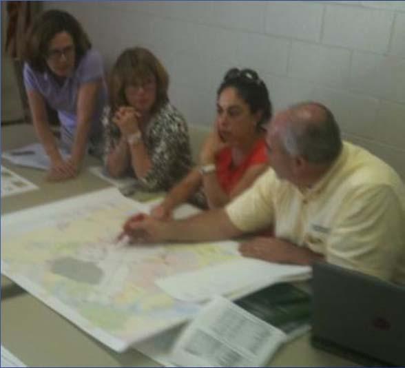
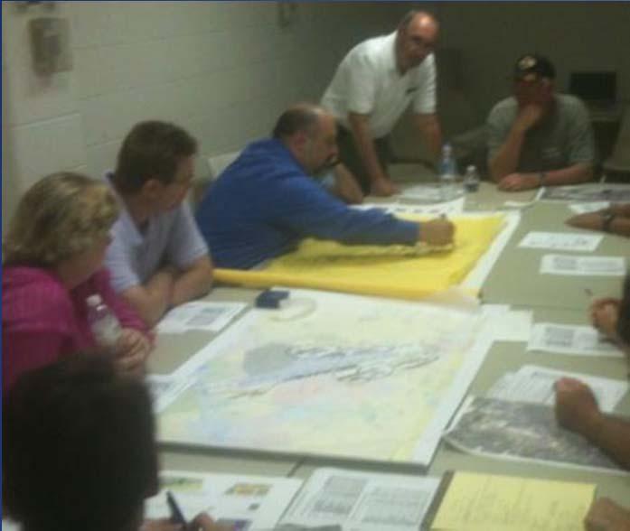
4 Definition of Land Use Elements Breakout Session Agenda Review Site Framework & Constraints Redevelopment Plan Design Charrette Breakout Sessions Planning Exercise No. 1 Define Employment Uses Insert photos of the maps or sketches discussed at the breakout tables Planning Exercise No. 2 Define Residential Uses Planning Exercise No. 3 Define Other Supportive Uses Planning Exercise No. 4 - Define Open Space & Recreation Needs


5 Redevelopment Plan Design Charrette Process Development Framework Airport Plan Non-Airport Plan


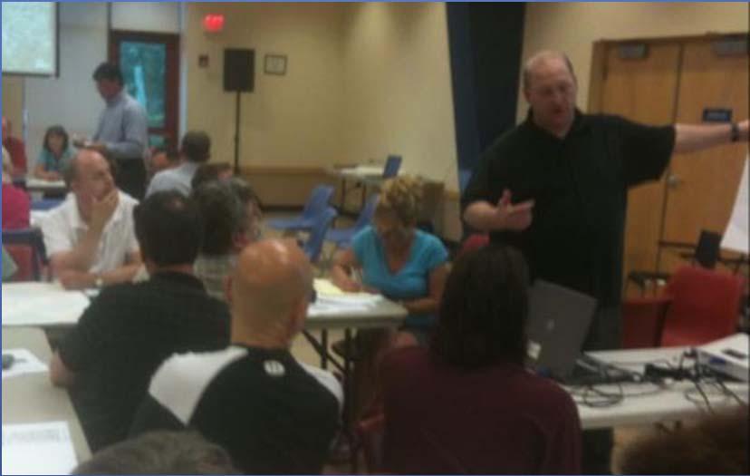
6 270 people attended the afternoon session 248 people attended the night session Redevelopment Plan Design Charrette Process 248


7 AIRPORT PLAN Dot Exercise

8 NON-AIRPORT PLAN Dot Exercise

9 Redevelopment Plan Acreage Comparison


10 Community Input


11 Town Center: Sense of place and community or Main Street for Horsham Unique identity that draws on Horsham s heritage Mixed uses: retail, residential, entertainment Open space and pedestrianfriendly 2 x 3 block area Limit to 4 stories Compatibility with airport scenario? Community Input on Land Uses: Employment Office Space: Higher-wage jobs Science/technology, green technology Corporate/regional headquarters University partnership with R&D Meeting/conference facilities
 Retail: No strip malls, no big box development Unique and integrated mix of shops, convenience, restaurants, entertainment Others: Medical offices, hospital, clinics, elderly")
12 Commercial / Light Industrial: Clean manufacturing, Green industries Pharmaceuticals, Cyber, IT, R&D Military/defense contracting Large users Market driven mix/diversity Community Input on Land Uses: Employment (cont d) Retail: No strip malls, no big box development Unique and integrated mix of shops, convenience, restaurants, entertainment Others: Medical offices, hospital, clinics, elderly care, social services Satellite university/college campus Expo center/conference center


13 Residential: Affordable senior housing 55+ communities Subsidized housing for veterans (small scale) Assisted living, CCRCs No high density Mix of single family and other Walkable communities tied to open space Sensitive to the impacts on the school district Low to medium density garden style units Limit large-lot estate homes Build traditional neighborhoods Compatibility with airport scenario Community Input on Land Uses: Residential

14 Other Uses: Cultural/performing arts center Outdoor amphitheater Museum or memorial: Navy/aviation heritage Multi-purpose community center, meeting space Regional athletic, gymnasium, and swimming center Indoor/outdoor theme park or water park Family entertainment center: theater, bowling Elementary/middle schools YMCA and other community recreational uses Police/fire training facilities Renewable energy: Solar, wind, natural gas Minor league baseball stadium Churches Link to train station from Town Center Community Input on Land Uses: Other Supportive Uses

15 Open Space / Recreation: Build on Horsham s excellent park system Integrated hiking/biking and exercise trails Lighted athletic fields with parking and seating Preserve natural areas and establish buffers Picnic areas within parks Integrate open space within development toward destinations Township pool Bocce, tennis, frisbee golf, volleyball Manmade reservoir or lake Campgrounds Teen center/skate park Bike lanes within roadway network Community-supported agriculture/farming Storm water management Community Input on Land Uses: Open Space & Recreation
16 ISSUES/CONCERNS Land Use Who cleans up contaminated land and to what level? What are the tax implications of the various land uses? What are the traffic implications? Will the proposed uses be economically feasible? Market analysis/development phasing What will the land cost?
17 ISSUES/CONCERNS BRAC Process Who makes final decision for the land? Who will finance, demolish and develop the project? What is the timing of the redevelopment? When will construction start? What control will Horsham have over an airport? Can future airport uses be regulated? Can more NOI s be submitted? Can the Reuse Plan be changed? Can the Navy reject the Reuse Plan?
18 OTHER OBSERVATIONS Balanced design plan Be Unique create a sense of place Economic diversity is critical Size and design of Town Center should meet local needs Plan should reflect the needs of our children


19 Preliminary Land Use Ideas


20 Land Use Ideas: Examples Performing Arts Center (Mann Center)


21 Land Use Ideas: Examples Washington Town Center


22 Land Use Ideas: Examples Williamsburg Town Center


23 Land Use Ideas: Examples Ann s Choice Senior Living - Warminster

24 Land Use Ideas: Examples Family Recreation Center - Arnolds

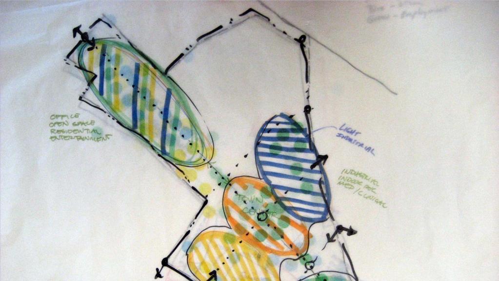
25 Preliminary Land Use Idea 611 Town Center Open Space Residential Research & Development Green - Light Industrial Institutional Educational Campus Mixed-Use Town Center Performing Arts Center

26 Preliminary Land Use Idea Major Features 611 Town Center Street Network Insert Land Use Scenario A
27 Preliminary Land Use Concept 611 Town Center Open Space Network Insert Land Use Scenario A Street Framework Diagram

28 Preliminary Land Use Idea Central Town Center Community Agriculture Open Space / Supporting Uses Residential Senior housing Corporate Headquarters Mixed-Use Town Center Performing Arts Center Commercial Educational Campus Medical Related Office / Institutional

29 Preliminary Land Use Idea Central Town Center Street Network Insert Land Use Scenario B Green Boulevard

30 Preliminary Land Use Idea Central Town Center Open Space Network Insert Land Use Scenario B Street Framework Diagram

31 Preliminary Land Use Idea Central Park Neighborhood Residential Green Innovation Retail Residential Townhomes Institutional / Public Schools Residential Central Park Retail Town Center / Senior Housing Residential

32 Preliminary Land Use Idea Central Park Neighborhood Street Network

33 Preliminary Land Use Idea Central Park Neighborhood Open Space Network


34 Preliminary Land Use Idea Airport Employment Open Space Office Park Institutional / Medical Green Innovation Industry Warehouse / Distribution

35 Preliminary Land Use Idea Airport Employment Street Network

36 Preliminary Land Use Idea Airport Employment Open Space Network
37 Preliminary Land Use Idea Airport Town Center Open Space Green Innovation Industry Institutional / Medical Town Center Office Park Commercial

38 Preliminary Land Use Idea Airport Town Center Street Network

39 Preliminary Land Use Idea Airport Town Center Open Space Network


40 Next Steps
41 Next Steps July August Recommendations on NOI Submissions to HLRA Presentation of Three Redevelopment Plan Alternatives for Consideration by the HLRA Board
4 C OMMUNITY D ISTRICTS
 4 C OMMUNITY D ISTRICTS N ew development in the Area will include many different types of land uses, including a destination retail area that attracts people from all over the region; recreation opportunities
SCORE CARD RESULTS. Power Tool Results. Vision Georgetown Draft Land Use Concept
 SCORE CARD RESULTS Power Tool Results Vision Georgetown Draft Land Use Concept Results of Public Consultation Open House Sept. 20, 2017 Positives - What do you like about the Plan? Walkability and Bike
Sahuarita District & Phase 1 Master Plan. Town Council December 11, 2017
 Sahuarita District & Phase 1 Master Plan Town Council December 11, 2017 Visioning Study Visioning Process Advisory Group Meetings Community Questionnaire Town Center Case Studies Community Analysis The
St. Louis Park Wooddale LRT Station Site development guidelines
 St. Louis Park Wooddale LRT Station Site development guidelines November 2013 OVERVIEW St. Louis Park s convenient location as a neighbor to Minneapolis means you re only minutes away from some of the
DRAFT PLAN PRESENTATION
 DRAFT PLAN PRESENTATION 1.23.2018 AGENDA Process Project Schedule Results from Visioning Workshop Draft Plan Highlights Concept Plans Feedback Next Steps PROJECT SCHEDULE KICK-OFF WORKSHOP August 29 th
CITY OF BOCA RATON GOVERNMENTAL CAMPUS Master Plan Progress August 22, 2017
 CITY OF BOCA RATON GOVERNMENTAL CAMPUS Master Plan Progress August 22, 2017 This is a rare moment in the City s history which affords us the opportunity to create a civic landmark born of comprehensive
To ensure that resources will be available to provide a consistent level of public services to the community.
 Future Land Use Plan The land use plan is one of the most prominent chapters in the Stillwater Comprehensive Plan. It provides a visual representation of what the community is expected to look like in
Pioneering the Sustainable Future of Pakistan. A New Destination of Islamabad
 Pioneering the Sustainable Future of Pakistan A New Destination of Islamabad A New Destination of Islamabad C A P I TAL S M A R T CIT Y ISL A M A B A D, PAKISTA N CAPITAL SMART CITY ISLAMABAD C A P I TAL
HE VISION. Building a Better Connected Place
 HE VISION Building a Better Connected Place WALK INTO THE FUTURE. Life in Cranberry, 2030 Here s what our residents told us they wanted to see in their community by 2030: The Cranberry of 2030 is a place
Equitable Growth Through TOD Planning
 Equitable Growth Through TOD Planning Community Meeting # 2 November 2017 Goals Objectives Extend investment from downtown Connect neighborhoods physically and economically Enhance places based on local
MEETING PURPOSE AND OVERVIEW
 MEETING PURPOSE AND OVERVIEW On February 23, 2012, the City of Elk Grove hosted the first of two community workshops related to the Southeast Policy Area. The workshop was held from 6:00 8:30 p.m. in the
Hopkins. Development Guidelines May Overview. Sponsored by: Blake Road Corridor Collaborative City of Hopkins
 Hopkins Blake Road LRT Station Area Development Guidelines May 2015 Sponsored by: Blake Road Corridor Collaborative City of Hopkins Overview Hopkins is a dynamic community of over 17,000 residents located
Atlanta BeltLine. Subareas 9 & 10. Master Plan Updates. March 26, Washington Park Jamboree 1
 Atlanta BeltLine Subareas 9 & 10 Master Plan Updates March 26, 2018 Washington Park Jamboree 1 22 miles, connecting 45 neighborhoods 22 MILES of transit 46 MILES of streetscapes and complete streets 33
Gold Line Bus Rapid Transit Transit Oriented Development (BRTOD) Helmo Station Area Plan
 Helmo Station Area Plan") Appendix F Gold Line Bus Rapid Transit Transit Oriented Development (BRTOD) Helmo Station Area Plan Introduction and Purpose of the Plan The Gold Line Bus Rapid Transit facility is an eleven-mile dedicated
Appendix F Gold Line Bus Rapid Transit Transit Oriented Development (BRTOD) Helmo Station Area Plan Introduction and Purpose of the Plan The Gold Line Bus Rapid Transit facility is an eleven-mile dedicated
ASPEN HILL Minor Master Plan Amendment
 ASPEN HILL Minor Master Plan Amendment Project Briefing Planning Board Agenda Item #7 Andrea Gilles, Area 2 June 5, 2014 Briefing Purpose 1. Follow-up evaluation on Mixed-Use land use in the Minor Amendment
Envision Front Royal Workshop 1 of 2
 Envision Front Royal Workshop 1 of 2 September 12, 2013 Summary The Envision Front Royal project held the first of two public workshops on September 12, 2013. The purpose of the workshop was to evaluate
Table of Contents. Elm Avenue Improvement Plan City of Waco, Texas. Introduction 1. Existing Context 1 Figure 1 2.
 Table of Contents Introduction 1 Existing Context 1 Figure 1 2 Plan Guidelines 3 Future Urban Form 4 The West-End 4 Main Street 6 The East-End 7 Figure 2 9 Public Improvement Recommendations 7 General
Plano Tomorrow Vision and Policies
 Plano Tomorrow Vision and Policies PLANO TOMORROW PILLARS The Built Environment The Social Environment The Natural Environment The Economic Environment Land Use and Urban Design Transportation Housing
Focus Groups. 8 Focus Group meetings including 2 with staff, 1 with seniors, and 1 with students
 Project Team Nan Lanahan, Parks & Recreation Jason Gallo, Parks & Recreation Rob Leslie, DEDP John Smolinsky, Planning Board Brent Meredith, Highway Joan Gavrilik, Friends of Parks & Rec MaryLyn Koval,
Status Report: MD 355 Project
 Status Report: MD 355 Project OCTOBER 2006 M-NCPPC MONTGOMERY COUNTY PLANNING DEPARTMENT Summary of Community Comments, and break to the Results of the MD 355 Participation Session Brookside Gardens -
Today Land & People. Northeast Nampa Gateway District. Employment. Land Use Characteristics. Demographics. Current Zoning
 Today Land & People Employment Major employers include Saint Alphonsus, the College of Western Idaho, the Auto Mall, Sorrento Lactalis and Walmart. 3,004 jobs in 2010 (COMPASS-CIM 2040 TAZ data) 4,345
Comprehensive Plan Advisory Panel Meeting #3
 Comprehensive Plan Advisory Panel Meeting #3 November 7, 2016 Agenda 1. September 19 th Meeting Notes 2. Summary of Focus Areas Charrette 3. Heart of the City Focus Area a. HOC2/Station Areas Concept &
Plano Tomorrow Joint Work Session
 Plano Tomorrow Joint Work Session City Council and Planning & Zoning Commission June 30, 2014 Strong Agreement More than 80% of respondents agreed with the statement. (9 of 16) Agreement Between 60% and
Asset-Based Development Scenario
 Asset-Based Development Scenario The Asset-Based development scenario emphasizes existing regional assets, concentrating future development around these assets. Regional assets include sports arenas, higher
Appendix A. Park Land Definitions
 Appendix A Park Land Definitions Mini Park May serve specific function for any and all ages, depending on need of the user area. Size range 1-5 acres with optimum size being 3 acres. Service area is sub-neighborhood
April 21, 2007 CCRP Workshop Summary
 April 21, 2007 CCRP Workshop Summary Group 1 1. Reuse around BART with a lot of housing and jobs 2. Greenway around creek 3. Transit and auto connection all through the site from Kirker Pass to Port Chicago
PLACEMAKING & MOBILITY WORKSHOP. January 27, 2016
 PLACEMAKING & MOBILITY WORKSHOP January 27, 2016 Boston needs more housing. But there is no one-size fitsall solution. Every neighborhood has its own character. In some places, density is not only appropriate
3 Vision and Goals. Vision and Goals. Blueprint for Bloomsburg. Vision. Town of Bloomsburg Comprehensive Plan,
 Vision and Goals 3 Vision and Goals Citizens of the Town of Bloomsburg clearly value their natural and cultural heritage, the walkable, mixed use pattern of downtown, the access to education, and the community
Mix of Uses Guide for Transit-Oriented Development MIX OF USES
 MIX OF USES Creating a Destination Magnet A diversity of uses such as retail, housing, offices, civic and entertainment within the TOD creates a destination magnet for transit users and TOD neighbors.
NACCED/NACo CONFERENCE JULY 10, 2015
 NACCED/NACo CONFERENCE JULY 10, 2015 Regional Growth Framework 2 Regional Growth Framework Regional Priorities Preferred Growth Concept Tools to Support Local Governments 3 Top Priorities for the CONNECT
Don Mills Crossing Study and Celestica Lands Development Application Community Meeting, Open House, and Breakout Discussions
 Consultation Summary Don Mills Crossing Study and Celestica Lands Development Application Community Meeting, Open House, and Breakout Discussions This report is not intended to provide a verbatim transcript
Design Fort Ord. welcome why we are here what happened this week design guidelines: ideas so far 2/12/2015. Regional Urban Design Guidelines (RUDG)
") Design Fort Ord Regional Urban Design Guidelines (RUDG) Welcome Back! Strategic Economics Alta Planning + Design National Charrette Institute Helix Environmental Planning Jeff Speck & Peter Katz Civitas
Design Fort Ord Regional Urban Design Guidelines (RUDG) Welcome Back! Strategic Economics Alta Planning + Design National Charrette Institute Helix Environmental Planning Jeff Speck & Peter Katz Civitas
Neighborhood Districts
 NEIGHBORHOOD DISTRICTS SEVEN MAIN DISTRICTS Neighborhood Districts While the Development Plan provides a broad-scale overview of the neighborhood, this section focuses on uses and relationships at the
MALL REVITALIZATION CASE STUDIES
 MALL REVITALIZATION CASE STUDIES DECEMBER 9, 2012 MALL REVITALIZATION OVERVIEW Introduction Sample Case Studies prepared for Lacey Woodland District Steering Committee as it considers strategies to revitalize
VIRGINIA / LAKE HIGHLAND TRANSPORTATION AND LAND USE STUDY
 VIRGINIA / LAKE HIGHLAND TRANSPORTATION AND LAND USE STUDY COMMUNITY MEETING #2 - PRESENTATION OVERVIEW 1 INTRODUCTION 2 CONTEXT STUDIES 3 VISION FRAMEWORK 4 DEVELOPMENT SCENARIOS 2 1 INTRODUCTION Project
12 th Street Connector Alignment Study VISIONING PUBLIC WORKSHOP - JUNE 25, :00PM TO 8:00PM
 12 th Street Connector Alignment Study VISIONING PUBLIC WORKSHOP - JUNE 25, 2018 6:00PM TO 8:00PM Goals for Today s Workshop Agenda: Project Introduction, Purpose, and Goals Existing Conditions Traffic
BAYFRONT INDUSTRIAL AREA RENEWAL STRATEGY
 BAYFRONT INDUSTRIAL AREA RENEWAL STRATEGY PIC #2 June 14 th, 2018 BACKGROUND & CONTEXT THE BAYFRONT INDUSTRIAL AREA 1,607 ha. Study Area Once housed over 50% of the City s employment Today home to over
Welcome. Community Consultation Meeting November 28, Review and discuss the Bathurst Quay Neighbourhood Plan Framework
 Welcome Community Consultation Meeting November 28, 2016 Why Are We Here Today? Review and discuss the Bathurst Quay Neighbourhood Plan Framework Review and discuss an Action Plan for Implementation Next
Municipal Plan*Assessment
 Municipal Plan*Assessment This tool was developed to assist in reviewing municipal master plans and in determining if these plans are consistent with smart growth principles, neighboring municipal plans,
Cobb County Design Guidelines Mableton Parkway & Veterans Memorial Highway Community Design Workshop January 12, 2017
 Community Design Workshop January 12, 2017 Agenda Opening Remarks / Introductions Scope of Work Existing Conditions Key Issues / Opportunities VPS Summary Draft Vision & Goal Statement Implementation Concepts
Refocus Kodak: Themes and Ideas to Date As of May
 Refocus Kodak: Themes and Ideas to Date As of May 21 2014 The Refocus Kodak Campaign has been hearing from the community since early 2014. Below are some of the themes that we have been hearing and some
Heart of the Triad A Dynamic Plan for the Future. Steering and Technical Meeting April 27, 2006
 Heart of the Triad A Dynamic Plan for the Future Steering and Technical Meeting April 27, 2006 The Week in Review Specific Group Findings There Was Uniform Agreement the Time Was Right Growth is Imminent
Canal Winchester Parks Master Plan. Public Meeting 2 Thursday, February 2 6:30pm
 Canal Winchester Parks Master Plan Public Meeting 2 Thursday, February 2 6:30pm Meeting Agenda 1. Project overview 2. Project schedule 3. Public input results Survey Public Meeting #1 Stakeholder Interviews
Development Agreement Public Meeting. June 26, 2013
 Development Agreement Public Meeting June 26, 2013 Process 2007 2008 2009 2010 2011 2012 2013 Neighborhood Conservation District Petition Process Original Master Plan presented Community Forum Glen Lennox
City Council March 27, Parks, Recreation, and Trails Master Plan
 City Council March 27, 2018 Parks, Recreation, and Trails Master Plan Planning Process Develop Goals and Objectives Inventory of Areas and Facilities Needs Assessment And Identification Public Participation
Pine Island Road Corridor Master Plan
 RECOMMENDED DEVELOPMENT PLAN Figure 9: Del Prado Village District Conceptual Framework The Conceptual Framework (Figure 8) for development of the Pine Island Corridor is to encourage mixed-use development
Summary Community Workshop #1 Fruitvale San Antonio Senior Center Monday, March 23, :00-9:00 p.m.
 Summary Community Workshop #1 Fruitvale San Antonio Senior Center Monday, March 23, 2009 7:00-9:00 p.m. Workshop Format and Process The City of Oakland is preparing a Specific Plan that will help define
SMART Plan East-West Corridor Land Use Scenario & Visioning Planning
 SMART Plan East-West Corridor Land Use Scenario & Visioning Planning Implementation Plan Charrettes January 2018 Presentation Outline 1. SMART Plan and Land Use Visioning Study Overview 2. Live Polling
Schedule B to Report PLS
 Page 25 Q1. The land use concept is made up of many different land uses (residential, commercial, parks, schools, environmental areas etc.) A number of land uses are concentrated in the Community Core,
East Central Area Plan
 East Central Area Plan Steering Committee Meeting January 10 th, 2019 Tears-McFarlane House Community Room East Central Area Plan Steering Committee Meeting January 10 th, 2019 CHUN Tears-McFarlane House
1. Parks & Recreation Neighborhood Parks Community Parks Special Use Sites 2. Open Space 3. Trails
 Appendix A: Park Classifications The intent of parks and recreation classifications is to aid in making acquisition and design decisions for park sites, facilities and the organization of recreation space
Overview of the Plan. The Building Blocks of Centers, Neighborhoods and Network INTERNAL DRAFT
 Overview of the Plan 4 East Davidson Ramah Church Rd June Washam Rd Bradford District Park Bradford Shearer Rd Campus District NC 73 Davidson-Concord North Rocky River This Master Plan projects an approximate
1120 Haist Street - Pelham Arena Community Co-Design Recommendation Report Haist Street - Pelham Arena Community Co-Design Recommendation Report
 1120 Haist Street - Pelham Arena Community Co-Design Executive Summary: In May, 2017 the Town retained the services of The Planning Partnership to undertake a community design charrette process to determine
Port Lavaca Future Land Use
 Port Lavaca Future Land Use Introduction The City of Port Lavaca is beginning to see sustained growth, after many years of relative stable population. New single family homes, apartments, and businesses
Silver Line CPAM UPDATE. Transportation and Land Use Committee October 14, 2016
 Silver Line CPAM UPDATE Transportation and Land Use Committee October 14, 2016 Purpose Recap Project History and Map Changes Provide Overview of CPAM Components Discuss Transportation Impacts Discuss Fiscal
Review of Opportunity Area C Draft Comprehensive Plan and Draft BOS Follow-On Motions. Special Working Group Meeting March 4, 2015
 Review of Opportunity Area C Draft Comprehensive Plan and Draft BOS Follow-On Motions Special Working Group Meeting March 4, 2015 The slides that follow identify where the draft Comprehensive Plan has
Welcome! to Keller Town Hall
 Welcome! to Keller Town Hall Keller Town Center Planning a New Downtown What is Keller Town Center? A new, growing downtown district planned as an urban village A combination of retail and office spaces,
Welcome. Comprehensive Plan & Transportation Plan Open House November 7, 2012
 Welcome Comprehensive Plan & Transportation Plan Open House November 7, 2012 Agenda Proposed future land use plan Comprehensive Plan strategies Traffic forecasts Future traffic operations Possible future
PLAN ELEMENTS WORKSHOP. April 5, 2016
 PLAN ELEMENTS WORKSHOP April 5, 2016 needs more housing. But there is no one-size fits-all solution. Every neighborhood has its own character. In some places, density is not only appropriate it is badly
Caroline Freeland Park Facility Plan Project
 Montgomery Parks Caroline Freeland Park Facility Plan Project Community Meeting #1 November 6, 2013 Bethesda Library 7:00-9:00 PM Welcome / Team Introductions Parker Rodriguez, Incorporated (Landscape
Isabel Neighborhood Plan: Alternatives
 Isabel Neighborhood Plan: Alternatives Presented by: Lori Parks, Associate Planner February 2, 2015 Agenda 1. Background on BART to Livermore 2. Isabel Neighborhood Plan 3. Alternative Scenarios 4. General
TABLE OF CONTENTS. Tables Table UC Davis Park and Open Space Resources
 TABLE OF CONTENTS 4.13 Recreation... 4.13-1 4.13.1 Environmental Setting... 4.13-1 4.13.2 Impacts and Mitigation Measures... 4.13-4 4.13.3 References... 4.13-8 Tables Table 4.13-1 UC Davis Park and Open
Strategic plan framework Steering Committee Meeting
 Strategic plan framework Steering Committee Meeting September 26, 2018 1 agenda 1 Welcome and Strategic Planning introductions Process Strategic Analyses Plan Framework 2 3 Brand Brand Development Naming
3.1 community vision. 3.3 required plan elements
 Chapter 3 Community Form 3.1 community vision 3.2 Parks & landscaping concepts 3.3 required plan elements D R A F T 20 Community Form Chapter 3 3.0 Community form 3.1 community vision The Specific Plan
Economy Vision Statements: Social Wellbeing Vision Statements: Natural Environment Vision Statements:
 Economy Vision Statements: 1. Our business environment makes us a region of choice for new employers as we encourage entrepreneurship and have a vibrant, diversified and resilient regional economy. 2.
8.0 Recreation and Open Space Element
 8.0 PURPOSE The purpose of this element is to ensure the provision of adequate and accessible recreation facilities and open space to meet the future needs of the University. (1) DATA REQUIREMENTS. This
Secrest Short Cut and Monroe Expressway Small Area Plan AUGUST 29, 2018
 Secrest Short Cut and Monroe Expressway Small Area Plan AUGUST 29, 2018 Background and Process Monroe Expressway will be open by the end of 2018 Union County and Indian Trail identified a need to revisit
CAMPUS PLACEMAKING: CAC WORK SESSION. August 23, 2018
 CAMPUS PLACEMAKING: CAC WORK SESSION August 23, 2018 AGENDA Public Realm Framework Overview & Discussion (~20 minutes) Health & Wellness Report Overview & Discussion (~15 minutes) Riverfront Update & Discussion
Navarre Town Center Plan. Prepared for the December 4, 2013 meeting of Navarre Inc.
 Navarre Town Center Plan Prepared for the December 4, 2013 meeting of Navarre Inc. N T C What is it? A plan. Created in 2004. Community-driven. Topic Areas: Land Use Infrastructure Landscaping Architecture
Lower Merion Commercial Districts Issues and Characteristics Handbook November 2013
 Lower Merion Commercial Districts Issues and Characteristics Handbook November 2013 DRAFT TOWNSHIP-WIDE VISION: To maintain and enhance commercial areas to complement the surrounding high-quality residential
Vision Statement for the Town of Flower Mound Master Plan The Town of Flower Mound Master Plan furthers the established community based vision to:
 Vision Statement for the The furthers the established community based vision to: Preserve the country atmosphere and natural environment that makes Flower Mound a unique and desirable community; Mitigate
Concord Community Reuse Project Goals and Guiding Principles. Overarching Goals (OG)
") Concord Community Reuse Project Goals and Guiding Principles Overarching Goals (OG) No priority is implied by the order of presentation of the goals and guiding principles. Overarching goals for the Concord
Concord Community Reuse Project Goals and Guiding Principles Overarching Goals (OG) No priority is implied by the order of presentation of the goals and guiding principles. Overarching goals for the Concord
CONTEXT: the Highway, the River + the Railroads run through us.
 CONTEXT: the Highway, the River + the Railroads run through us. I-25 36 In the past they have divided us, now we have an opportunity to unite us. I-76 I-270 I-76 CSU I-25 LEGEND Cut + Cover River North
U T D N o r t h C a m p u s T O D and D o w n t o w n D e n t o n T O D
 U n i v e r s i t y o f T e x a s a t D a l l a s C i t y o f R i c h a r d s o n U T D N o r t h C a m p u s T O D and D o w n t o w n D e n t o n T O D Rick Leisner, AICP Assistant Director of Development
Visioning Statement and Guiding Principles
 Visioning Statement and Guiding Principles Planning for the Future The General Plan The General Plan represents Woodland's shared vision of the future and defines a path to lead the community toward its
This is the East Carolina University Comprehensive Facilities Master Plan Final Draft Plan Review. This workbook reviews the campus draft master plan
 This is the East Carolina University Comprehensive Facilities Master Plan Final Draft Plan Review. This workbook reviews the campus draft master plan first presented on campus on June 29 and June 30, 2011.
Broken Arrow Comprehensive Plan Update Public Workshop Meeting #3 January 23,
 Broken Arrow Comprehensive Plan Update Public Workshop Meeting #3 January 23, September 25,2018 2018 26 April 2016 AGENDA 1. Status Presentation - Charrette Recap - Proposed Vision Framework - Preliminary
Community Working Group Workshops - Workshop Summary September TOD Corridor Strategy and Access Planning Study. Workshop Introduction
 Community Working Group Workshops - Workshop Summary September 11-13 2018 TOD Corridor Strategy and Access Planning Study With VTA s BART Phase II (the Study), VTA seeks to build upon existing transportation
CITY OF UNION CITY MINUTES GENERAL PLAN ADVISORY COMMITTEE
 CITY OF UNION CITY MINUTES GENERAL PLAN ADVISORY COMMITTEE WEDNESDAY, MARCH 4, 2015, 6:30 P.M. IN THE CITY COUNCIL CONFERENCE ROOM OF CITY HALL 34009 ALVARADO-NILES BLVD., UNION CITY, CALIFORNIA Attachment
DOMINION BOULEVARD CORRIDOR STUDY AND ECONOMIC DEVELOPMENT STRATEGIC PLAN A MODEL FOR CHESAPEAKE S FUTURE
 DOMINION BOULEVARD CORRIDOR STUDY AND ECONOMIC DEVELOPMENT STRATEGIC PLAN A MODEL FOR CHESAPEAKE S FUTURE Overview I. Draft Plan Process II. Draft Plan Overview a. Market Analysis b. Master Land Use Plan
Union City General Plan Update. City Council Meeting Item VII.a July 28, 2015 Land Use Concepts and Evaluation Criteria
 Union City General Plan Update City Council Meeting Item VII.a July 28, 2015 Land Use Concepts and Evaluation Criteria Meeting Outline The Update Process Overview and Purpose Draft Focus Area Concepts
This Review Is Divided Into Two Phases:
 Semiahmoo Town Centre Review The purpose of this review: To review the Semiahmoo Town Centre Concept Plan, originally approved in 1993, to ensure that this centre will continue to serve the needs of South
Parks, and Recreation & Cultural Arts Master Plan Update
 Parks, and Recreation & Cultural Arts Master Plan Update Community Profile Public Input Summary: Staff Interviews conducted April 14 and 15, 2014 Citizens Workshop - conducted April 15 th and 24 th, May
VILLAGE OF ROMEOVILLE
 VILLAGE OF ROMEOVILLE COMPREHENSIVE PLAN FRAMEWORK PLAN, KEY STRATEGIES & GUIDING PRINCIPLES December 8, 2016 KEY PLANNING THEMES 2 KEY PLANNING THEME #1 ADVANCING A BALANCED ECONOMIC BASE KEY PLANNING
Tropicana Site Redevelopment Committee of the Whole September 8, Image: City of St. Petersburg
 Tropicana Site Redevelopment Committee of the Whole September 8, 2016 Image: City of St. Petersburg City of St. Petersburg Planning & Economic Development Department Leading the Process HKS Urban Design
CHAPTER 3 VISION, GOALS, & PLANNING PRINCIPLES. City of Greensburg Comprehensive Plan. Introduction. Vision Statement. Growth Management Goals.
 CHAPTER 3 VISION, GOALS, & PLANNING PRINCIPLES Introduction The Greensburg Comprehensive Plan is intended as a working community document. A combination of long and short-term goals, this document is intended
NARRATIVE STATEMENT OF JUSTIFICATION
 NARRATIVE STATEMENT OF JUSTIFICATION for Village of Accotink Mixed Use Project Rezoning Application Bainbridge Communities Acquisition III, LLC Tax Map # 109 1((1))5 9 & 13 16 March 30, 2012 INTRODUCTION
CENTRAL ESTUARY PLAN AVISION FOR OAKLAND S WATERFRONT
 Central Estuary Plan A VISION FOR OAKLAND S WATERFRONT Specific Plan and Environmental Assessment Presentation to the Parks and Recreation Advisory Commission December 9, 2009 This Afternoon s Presentation
RESEDA - WEST VAN NUYS COMMUNITY PLAN
 RESEDA - WEST VAN NUYS COMMUNITY PLAN Executive Summary As part of the initial outreach effort, the Department of City Planning hosted two workshops for the Reseda-West Van Nuys Community Plan Area during
Planning Districts INTRODUCTION
 INTRODUCTION To facilitate detailed examination of development prospects for all areas of the community, Delano has been divided into 14 planning districts. The location of these planning districts is
Downtown Dubuque...it s a great time.
 Downtown Dubuque...it s a great time. Your timing could not be better to invest in Downtown. With hundreds of millions in public and private investment occurring on the City s downtown waterfront, millions
In surveys, Dallas residents say what they want to change most
 NEIGHBORHOODS ELEMENT In surveys, Dallas residents say what they want to change most in the city is its appearance they want it to look beautiful, with trees and pedestrian-friendly neighborhoods. The
Downtown Elkton Station Area Plan, Elkton, MD. Difficult enough to get support for new starts challenge to fund Houston transit
 Difficult enough to get support for new starts challenge to fund Houston transit More difficult to build Community Support for dense development at station areas Major Concerns: Traffic, Property values,
Public may provide comments on the GDP within the next two weeks (December 24)
") 25/70 General Development Plan (GDP) Public Meeting Wednesday, December 10, 2014 6:00 8:00 P.M. District 1 Police Station Community Room 1311 W 46th Ave, Denver, CO 80211 Council Woman Montero: This particular
25/70 General Development Plan (GDP) Public Meeting Wednesday, December 10, 2014 6:00 8:00 P.M. District 1 Police Station Community Room 1311 W 46th Ave, Denver, CO 80211 Council Woman Montero: This particular
Small Area Plan. South Gateway
 Small Area Plan Adopted May 12, 2008 South Gateway Purpose. The South Gateway Small Area Plan defines the City s expectations for the future of the southern entrance to the City at Interstate 85 and Highway
Comprehensive Parks and Recreation Master Plan. Executive Summary. Submitted To: City of Milton, GA October 2012
 Comprehensive Parks and Recreation Master Plan Executive Summary Submitted To: City of Milton, GA October 2012 Executive Summary The City of Milton envisioned the need for an effective Master Planning
Corridor Background. Defining the Corridor Study Area. Lake Street. 38th Street. 46th Street
 1 Corridor Background Defining the Corridor Study Area Minnehaha Avenue (CSAH 48) and Hiawatha Avenue (MN 55) are parallel diagonal roadways, approximately three blocks apart, that provide two direct arterial
TEAM INPUT SUMMARY. Postcard Image?
 DOWNTOWN MAULDIN TEAM PUBLIC INPUT TEAM INPUT SUMMARY Postcard Image? A nice neighborhood The main city center with government buildings Mauldin entry sign, high school, Cultural Center, Sunset Park, Hall
ESTABLISH AN EFFICIENT TOWN CENTER
 ESTABLISH AN EFFICIENT TOWN CENTER 4 Overview Lisbon residents are proud of the history of Newent and at the same time recognize its current importance as a centralized location for a variety of municipal
Chapter 1: Introduction
 Chapter 1: Introduction The Penn Avenue Community Works Corridor Vision and Implementation Framework presents an integrated communitybased vision and a coordinated, long-term implementation framework for