Outdoor Recreation and Open Space Plan
|
|
|
- Myles Thompson
- 6 years ago
- Views:
Transcription


1 Outdoor Recreation and Open Space Plan Prepared by: Village of Allouez In In conjunction with: Village of Allouez Parks, Recreation, & Forestry Committee and Brown County Planning Commission
2 Open Space and Outdoor Recreation Plan Development Team Village of Allouez Susan Foxworthy, Village Administrator Brad Lange, Parks Rereation, & Forestry Director Debbie Baenen, Clerk-Treasurer Ralph Witte, Building Inspection/Zoning Craig Berndt, Public Works Director Matthew Bauman, Intern Village of Allouez Board of Trustees Steve Vanden Avond, President Ray Kopish Lynn Green Randy Gast Alan Swatloski Paul Zeller Penny Dart Allouez Park, Recreation, & Forestry Committee Robert Gille, President Robert Michels Janna Zimmerman Ellen Schumacher Peter Hentges Lisa Evenson Steve Bostedt Brown County Planning Commission Chuck Lamine, AICP, Planning Director Cole Runge, Principal Planner Aaron Schuette, Senior Planner Peter Schleinz, Senior Planner Jon Motquin, Senior Planner Lisa Conard, Planner Dan Teaters, Planner Jeff DuMez, LIO Coordinator 1
3 RESOLUTION ADOPTION OF THE VILLAGE OF ALLOUEZ OUTDOOR RECREATION AND OPEN SPACE PLAN WHEREAS, the Village of Allouez, County of Brown, State of Wisconsin, has endorsed the development of a Village Outdoor Recreation and Open Space Plan; and WHEREAS, the Village of Allouez Outdoor Recreation and Open Space Plan encompasses a general outline and plan for the recreational development of the Village; and WHEREAS, this plan has been reviewed by the Village of Allouez Parks, Recreation and Forestry Committee, which recommend adoption thereof. NOW THEREFORE, BE IT RESOLVED by the Allouez Village Board that the Village of Allouez, County of Brown, State of Wisconsin, Outdoor Recreation and Open Space Plan be adopted as the approved Comprehensive Outdoor Recreation Plan for the Village. Signed this day of October by: Steve Vanden Avond, Village President Susan L. Foxworthy, Village Administrator 2
4 Table of Contents 1. INTRODUCTION...4 PURPOSE OVERVIEW OF THE VILLAGE...5 MISSION STATEMENT...5 HISTORY...5 LOCATION OF THE VILLAGE OF ALLOUEZ...5 NATURAL RESOURCE FEATURES...7 DEMOGRAPHICS...8 LAND USE GOALS AND OBJECTIVES OF THE PLAN...10 PARK ACQUISITION AND DEVELOPMENT...10 PARTNERSHIPS...10 INTERGOVERNMENTAL COORDINATION...10 PURPOSE...11 GOALS AND OBJECTIVES INVENTORY OF VILLAGE PARKS, TRAILS, & OPEN SPACES...13 PARK CLASSIFICATIONS...15 INVENTORY OF VILLAGE OF ALLOUEZ PARKS, TRAILS AND FACILITIES...16 INVENTORY OF PUBLIC SCHOOL SITES IN ALLOUEZ INVENTORY OF NEARBY RECREATIONAL PARKS AND FACILITIES...20 INVENTORY OF LOCAL PARKS, TRAILS AND FACILITIES NEAR ALLOUEZ PUBLIC PARTICIPATION NEEDS ASSESSMENT...24 RECREATIONAL NEEDS STANDARDS...24 SERVICE AREA ANALYSIS...27 RECOMMENDATIONS OF THE PREVIOUS ALLOUEZ PARK PLAN...27 SUMMARY OF FACILITY NEEDS RECOMMENDATIONS...30 SITE ACQUISITIONS PROPOSED...30 PROPOSALS FOR EXISTING PARK SITES...31 COMMUNITY-WIDE RECOMMENDATIONS...32 CAPITAL IMPROVEMENTS PARKS AND RECREATION FUNDING OPPORTUNITIES...34 GRANT PROGRAMS...34 APPENDIX
5 1. Introduction Outdoor recreation and open space are defining characteristics of our communities. They lend form and function to our community and enhance its attractiveness and foster a sense of civic pride. Additionally, the provision of an adequate supply of areas, facilities and activities to accommodate the public s recreational needs has been demonstrated to promote the general health, welfare, and safety of our communities and citizens. The Village of Allouez Outdoor Recreation and Open Space Plan represents a bold commitment by the Village to fully embrace environmental stewardship of the land. Today s citizens expect public government to satisfy a large portion of our recreation and open space needs. Parks and open space today are viewed as a public good, much as the same as that of our roads bridges, and sewers. The Village assumes the provision of an equal or greater amount of public good provisions for each subsequent generation. Local governments are recognized as having the responsibility to allocate open space and park facilities to the public. To provide these recreational services in an efficient and effective manner, planning principals and guidelines are often included as an integral element of outdoor recreation and open space programs. That process is typically formalized in a Park and Open Space Plan. Purpose This report presents Allouez third Outdoor Recreation and Open Space Plan, and is intended to be a comprehensive update of the previous Plan prepared by the Brown County Planning Commission, which was adopted by the Village on the 21 st of March, This Plan provides an inventory of current outdoor recreation and open spaces within the Village of Allouez, and identifies the anticipated future demands and needs for outdoor recreation and open space sites and facilities. The document sets forth and prioritizes the actions which should be pursued to meet those future needs, and is intended to serve as a guide for the Village in its provision of outdoor recreation and open space sites and facilities for at least the next five years. This Plan is the culmination of a cooperative effort underlining many of the recommendations made by the Village of Allouez Parks, Recreation and Forestry Department, the Village of Allouez Parks, Recreation and Forestry Committee, and Village residents throughout In addition, various non-profit groups and volunteer organizations have participated in many of the recommendations in this Plan. Such groups include the Allouez Beautification Committee, Friends of the Fox River Trail, the Allouez Kiwanis Club, and the Allouez Optimist Club. When adopted by the Allouez Village Board, and endorsed by the Wisconsin Department of Natural Resources, this Plan will maintain the Village s eligibility to apply for and receive state and federal grants and funds for open space and outdoor recreation purposes. Any request for park, open space or outdoor recreation funding must be consistent with the recommendations of this Plan to be eligible for that funding. Furthermore, consistent review and implementation of this Plan over time will assure the costeffective and coordinated provision of open space and outdoor recreation opportunities to the Village of Allouez. Recommendations are provided in subsequent sections that address foreseeable needs within the time horizon of this study. Needs may change over time in response to community input. 4
6 Mission Statement 2. Overview of the Village We are to be a responsive municipal government which provides efficient and cost effective services to a mature residential community History The community which would one day become known as the Village of Allouez was named after Father Claude Jean Allouez, the French missionary priest who, in 1665, established the first religious mission in the Northwest Territory near Ashland, Wisconsin. It was Father Allouez who later traveled to the Green Bay area, and in 1671, built the first permanent European settlement in the state, the St. Francis Xavier mission along the Fox River near the De Pere rapids. Although Europeans had visited the Brown County area as far back as the mid-1600 s, and a permanent settlement had been established in the Green Bay area by the mid-1700 s, it was not until the mid-1800 s that significant development began in the area that is today known as the Village of Allouez. Furthermore, it was not until the 1870 s that the community truly began to form, when the Town of Allouez was created by detaching lands lying between the Fox River and what was then known as the Devil River (later renamed the East River) from the Town of Bellevue. Over the years, the Town of Allouez quietly but steadily grew into a community of predominantly residential, institutional and agricultural uses. However, such growth eventually resulted in development of most of the community s agricultural lands, so that by 1990, only a few acres remained. Today, Allouez is a community of principally residential land uses, so much so in fact, that Allouez has the greatest percentage of lands in residential use than any other community in Brown County (see map 2, p.9). The latest event of historical significance for Allouez occurred in 1986, when after more than two decades of intermittent debate the Town incorporated and became the Village of Allouez. It is also interesting to note that at that time, geographically, Allouez had been the smallest town in the state of Wisconsin. Location of The Village of Allouez As shown in Map 1 (p.6), the Village of Allouez is located in central Brown County between the Fox River and the East River, and is approximately 5.1 square miles in extent (including surface waters of the Fox and East Rivers). It is bordered on the north by the City of Green Bay, on the west by the Village of Ashwaubenon, on the south by the City of De Pere, and on the east by the Town of Bellevue. Major highways within the Village include State Highway 172, which runs east-west through the central portion of the Village, State Highway 57, which parallels the Fox River in the western portion of the Village, and County Highway X, which runs north-south through the central portion of the Village 5
7 Map 1 Brown County Municipal Boundaries PULASKI PITTSFIELD SUAMICO HOWARD Green Bay SCOTT GREEN BAY(T) GREEN BAY HUMBOLDT HOBART ASHWAUBENON ALLOUEZ BELLEVUE DE PERE EATON LEDGEVIEW LAWRENCE ROCKLAND GLENMORE NEW DENMARK DENMARK WRIGHTSTOWN MORRISON HOLLAND Miles Allouez_Municipalities.mxd - 07/09
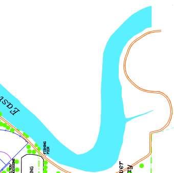
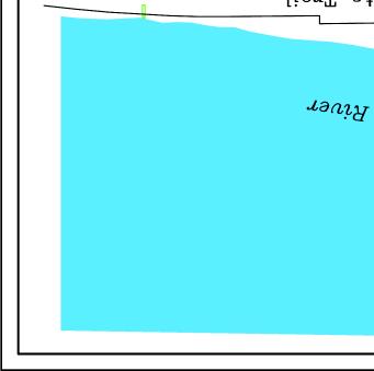
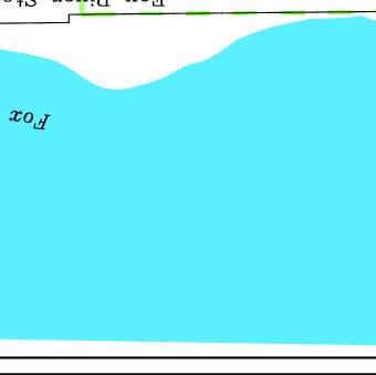
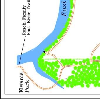
8 Natural Resource Features As is common with most of the county and state, the Village of Allouez topography has been shaped by past glacial action. In this regard, it can be noted that the Fox River, which borders the Village on the west, is a continuation of the same depression created by the glaciers that formed the bay of Green Bay and Lake Winnebago. The Fox River flows northward through this depression and enters the bay about three miles north of the Village. Paralleling the Fox River, and running approximately through the middle of the Village of Allouez, is a ridge roughly 50 feet higher in elevation than the Fox River. Webster Avenue runs along the top of this ridge, and both sides offer scenic views of the surrounding area. It was in part for this reason that this portion of Allouez developed more rapidly, and more densely, than any other portion of the Village. Bordering the eastern boundary of the Village of Allouez is the East River, one of the larger tributaries of the Fox River. The East River is a slow moving river that also flows north and enters the Fox River about 1.5 miles north of the Village. Along the shores of the East River is the East River Parkway, which is an area of open space that was identified as such since the first City Plan for Green Bay in A one-time popular boating and recreational waterway, the East River has since lost its popularity due to water quality. The river has been recognized as a Priority Watershed by the Department of Natural Resources in 1986, and provided the funding for various restoration projects. With the help of the East River Priority Watershed Project, citizen groups, and the efforts the Village has made to improve the water quality, the East River should again become a popular recreational area in the Village The Fox River forms the western boundary of the Village. This river flows north into Green Bay, which is a major bay of Lake Michigan. This river offers an assortment of recreational opportunities for Village residents that were nearly lost. While historically the river has experienced poor water quality, recent cleanup efforts have been relatively successful. This improvement has, in turn, led to a resurgence of interest in fishing, boating and other recreational opportunities along the river. The Fox River State Trail runs through the Village and beyond on the east bank of the river. It is also important to note that since 1972, the Brown County Planning Commission has identified and inventoried the most important water-based natural resource features within the urban and urbanizing portions of the county. Such natural resource features have been termed Environmentally Sensitive Areas (ESA s). These ESA s are comprised of geographic areas of the landscape encompassing especially valuable natural resource features such as lakes, rivers, streams, wetlands, and their associated undeveloped shorelands, floodlands and areas of steep slopes. State and County rules require that these areas not be developed for sewered purposes, and recommend that they be permanently preserved and protected. Such areas encompass approximately 1.0 square mile, or about 20 percent, of the Village. The proportionally large amount of open space along the East River is due to these ESA s. Environmentally Sensitive Areas within the Village are located along both the East and Fox Rivers. 7
9 Demographics Based on data from the 2000 U.S. Census, the Village of Allouez had a population of 15,443. The Wisconsin Department of Administration estimated the 2008 population to be approximately 15,470, which makes it the fifth most populous municipality in Brown County. However, as can be seen in Figure 1, Allouez growth has increased by only 1,690 persons between 1970 and In January 2002, the Wisconsin Deparment of Administration (WDOA) projected the Village of Allouez to grow to 15,651 people by 2010, to 16,259 people by 2020, and to 16,619 people by Figure 1: Past and Projected Populations for Allouez ( ) Population 18,000 16,000 14,000 12,000 10,000 8,000 6,000 4,000 2, ,621 3,561 5,315 9,577 13,753 14,882 14,431 15,443 15,651 16,259 16, (proj) 2020 (proj) 2030 (proj) *Sources: Wisconsin Dept. of Administration, 2008 According to the U.S. Census, the median age of Allouez residents in 2000 was 37.6 years, which is slightly higher than the 1990 median age of 34.8 years and Brown County s 2000 median age of The 2000 Census also found that the number of school-aged (K-12) children increased by only 1.5 percent over the last ten years, while residents between the ages of 20 and 54 increased by 8 percent, and residents above the age of 55 increased by 16.7 percent. This trend indicates that the Village contains an increasing number of older residents who will require special services as they continue to age. Land Use By 2009, the Village of Allouez has become almost completely developed, with only a few small areas remaining for development and in-fill. Map 2 (p.9) shows current land uses in the Village. One can see from this map the high proportion areas that support residential use. This further supports the allocations of parks and open spaces within the Village. 8
10 Map 2 Allouez Land Use Map Legend S MONROE AV Residential Commercial Industrial Recreation & Open Spaces Governmental & Institutional Transportation RIVERSIDE DR W ST JOSEPH ST E BEAUPRE ST KALB AV W ALLOUEZ AV E ST JOSEPH ST DAUPHIN ST E ALLOUEZ AV S WEBSTER AV GREENE AV BELL CT EAST RIVER DR STH 172 BROADVIEW DR LIBAL ST S CLAY ST HOFFMAN RD KENNEY ST Miles LONGVIEW AV Ê Allouez_Zoning.mxd - 07/09
11 3. Goals and Objectives of the Plan This section supports the variety of needs and desires that foster and support the stewardship of cultural, historical, and natural resources throughout the community and surrounding area. Park Acquisition and Development Given the extent of development within the Village of Allouez, opportunities for park acquisition are relatively limited. There is an established need for a neighborhood park in the west and northwest portions of the Village, yet there are relatively few open space lands available for development. While the Village should continue to review potential site acquisitions, there maintains a need to renovate, repair, and upgrade existing parks and recreational facilities to accommodate demand, efficiency, safety, and accessibility. Therefore, this Plan primarily addresses the needs for existing parks, trails, and open spaces within the jurisdiction based on level of service standards and recommendations from Village staff, committees, and residents. Partnerships Partnerships with agencies such as the Green Bay School Districts, businesses, developers, nonprofit organizations, and neighborhood groups, will play an important role in the development of active and passive recreational opportunities for the Village of Allouez. The schools within the Village offer fields, gymnasiums, and other amenities that can be used to offer recreational programs. In some cases, school and park sites can be combined in order to provide shared and enhanced recreational opportunities for residents. Neighborhood and business group partnerships can provide land or facilities for parks and recreation. This might include cost-sharing for acquisition and development, furnishing materials or equipment, or provision of maintenance and security. Some examples include the purchase of play equipment for a local park by community groups, or existing businesses might contribute trees, building, or funds to maintain these elements in the business areas. The Village may consider incentives for donations such as commemorative plaques or renaming a park in honor of donors. Intergovernmental Coordination The Village of Allouez is adjacent to five other jurisdictions that are all within Brown County. Since a park s service area does not recognize municipal boundaries (see map 5, p.26), it is beneficial to the Village to maintain adequate dialogue with neighboring municipalities. As neighboring communities continue to develop and mature, so do the service demands of associated parks. Within this Plan include recommendations for the linking of the Allouez park system with neighboring municipalities. Currently, the Resch Family East River Trail and the Fox River State Trail are multijurisdictional, and provide linkages between municipalities. Increasing a park s accessibility will typically increase the overall use of a park system, but may potentially decrease the service area of another park. Proper coordination of all affected municipalities is necessary for an efficient system. 10
12 Purpose A major element of any planning process is the identification of a common vision for the community. However identifying such a vision in recreation planning is often difficult to achieve because values held by citizens are complex and sometimes elusive to park and recreation decision makers. Yet, with incorporation of a community supported set of goals into a plan, a framework is established which enables the community to identify and measure its progress towards its vision. A practice followed by many communities to incorporate such a framework into their plans, and one used by the Village of Allouez in its previous park Plan, is the identification of goals and objectives. Therefore, this Park Plan will utilize and build upon the Village s previously established framework of open space and outdoor recreation goals and objectives. Goals and Objectives Goals represent desired situations toward which planning efforts should be directed. They are broad and long-range. They represent an end to be sought, which may never be fully realized. Objectives describe more specific purposes which should be sought to advance toward achievement of the goals. They are targets along the path to satisfying the goals. The following goals and objectives are meant to guide Village officials and staff as they work to improve the Village s park and open space system. Together, the goals and objectives indicate the type of outdoor recreation and open space system the Village would like to provide for its residents and visitors, and a means to work toward providing it. The goals address three aspects of a recreation system, the first dealing with the provision of outdoor recreation sites and facilities, the second dealing with the provision of open space, and the third dealing with the intent and purpose of this Plan. Goal: To provide and preserve an extensive system of outdoor recreation areas which offer a diversity of recreational activities to all current and future Village residents. Objectives: Provide and maintain parks with recreational facilities to accommodate residents of all ages and physical abilities. To encourage the health, safety and welfare of all park users by maintaining ADA compliance, adequate security, and maintenance of facilities. Protect existing parks and parkway lands from development. Acquire and develop parkland in the western and/or northwestern portions of the Village, commensurate with Level of Service (LOS) standards, to be within a reasonable proximity to all Village residents. Preserve existing and provide additional public accesses to the East and Fox Rivers. 11
13 Preserve existing and provide additional access points to the Fox River State Trail and Resch Family East River Trail Incorporate energy efficient materials into future facility developments. Goal: To preserve unique and significant open space and natural resource areas of the Village. Objectives: Protect and enhance Environmentally Sensitive Areas, including shorelines. Identify and establish priorities for acquiring and/or developing needed outdoor recreation areas and facilities. Encourage landowners to donate land or conservation easements for future parks Cooperate with local public and private enterprises, churches, and schools for providing needed recreation areas and facilities. Ensure the environmental quality of the Village s open spaces and wildlife habitats. Protect the valuable and significant wetlands in the Village which serve as fisheries, wildlife habitat areas, surface water runoff areas, and open space areas. Goal: To maintain a current and meaningful Plan which meets the changing needs of Village residents. Objectives: Provide an action plan which is reasonable, up-to-date, and reflects the Villages s priorities, resources, and changing leisure activities. Provide for periodic review and evaluation of the Plan to keep it current, usable, and eligible for grant funds. Encourage new and facilitate existing relationships between the Village, residents and community organizations in plan development. To encourage dialogue and coordination between the Village and other jurisdictions, communities, and associated governing bodies in planning, conflict resolution and park development. 12
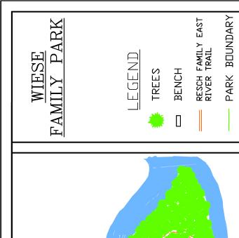
14 4. Inventory of Village Parks, Trails, & Open Spaces *Appendix A contains detailed maps of each of the existing Village-owned sites Table 1: Allouez Park and Open Space Sites: 2009 Parks Acres Parking Lot Ball field(s) Soccer Fields Volleyball Courts Basketball Courts Tennis courts Skating Rink/Hockey Broadview Park 17.4 X 5 X X X East Lawn Park 4.9 X X X X X X X X X Green Isle Park 51.4 X 2 1 X X 4 X X X X X X X X 2 X X X X Kiwanis Park 38.3 X 3 X 2 X X X X X X Langlade Park 6 X X X 2 X X X X Optimist Park 10.2 X X X X X X X PHM Webster Park S.C X 6 X 2 X X X X X Riverview Park 17.5 X 5 X X X X X X St. Francis Park 3.4 X X X X Sunlight Park 2.3 X X X Sunset Park 3.6 X X X Wiese Family Park 28.8 X 3 X X X X X X Special Use Facilities Allouez Community Center Allouez Optimist Kayakers Point East River Parkway/East River Trail* Fox River State Trail Heritage Hill State Park Public Schools Doty Elementary School Langlade Elementary School Webster Elementary School N/A 102.2/ 2.3 mi. 22.9/ 2.9 mi. X X Open Shelter Shelter/Restrooms 48.5 X X *Acreage excludes areas within existing parks 11.6 X X X X X 7.2 X X X X X X Concession Stand Picnic Tables Benches Gazebo Grills Playgrounds Fishing Pier Boat/Canoe Launch X Paved Trails Nature Trails Flower Bed(s) 13
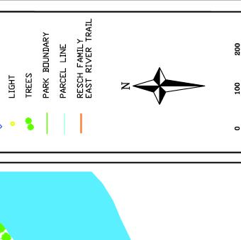
15 Map 3 Village of Allouez Parks and Open Space System St. Francis Park KALB AV Fox River State Trail RIVERSIDE DR Webster School Allouez CommunityCenter P.H. Martin Webster Park Sports Complex Optimist Park E ST JOSEPH ST East Lawn Park East River Parkway Allouez Optimist Kayakers Point E ALLOUEZ AV LAZARRE AV St. Matthews School Heritage Hill State Park GREENE AV LIBAL ST East River Parkway Sunset Park Sunlight Park ROSELAWN BLVD S WEBSTER AV STH 172 Langlade Park Langlade School HOFFMAN RD Broadview Soccer Complex Riverview Park Green Isle Park Legend Allouez Schools Multi-Use Trails Allouez boundary County Lands State Lands Village Lands East River Parkway LONGVIEW AV LEBRUN RD Resurrection School Doty School EAST RIVER DR Kiwanis Park Miles Wiese Park East River Parkway Resch Family East River Trail Resch Family East River Trail Allouez_sites.mxd
16 The Fox River, East River, and lowland vegetation related to the East River floodplain and adjacent wetlands are the primary natural resources in the Village of Allouez. A total of acres of outdoor recreation and open space land is currently available for public use in Allouez. This number also includes public schools in Allouez, which also have land available for public use. In 2009 there were two state-owned, thirteen Village-owned, one county-owned, and three public school district-owned park and open space sites within the Village of Allouez. A detailed inventory of facilities within these parks is noted below. Park Classifications To meaningfully evaluate recommendations and standards within a Park Plan, a park classification system is essential. Generally, the size and character of each site determines the type and quantity of facilities that are likely to be developed. The Village has a park classification system to differentiate parks according to their size, character and the type of facilities likely to be associated with them. Table 2: Park and Open Space Classifications Classification General Description Service Area Size Criteria Examples Mini-Park Neighborhood Park Used to address limited, isolated or unique recreational needs. Remains the basic unit of the park system and serves as the recreational and social focus of the neighborhood. Focus is on the informal active and passive recreation Less than a 1/4 mile distance in residential setting 1/4 to 1/2 mile distance and uninterupted by nonresidential roads and other physical barriers Typically between 2,500 sq. ft. and 1 acre 2 acres minimum acres is considered optimal None East Lawn Park Kiwanis Park Langlade Park Optimist Park Sunlight Park Sunset Park PHM Webster Park S.C. Community Park Serves broader purpose than neighborhood park. Focuses on community-based recreation needs, and/ or preserving unique landscapes and open spaces Determined by the quality and suitability of the site. Usually serves two or more neighborhoods and 1/2 to 3 mile distance. As needed to accommodate desired uses. Usually between acres Green Isle Park Kiwanis Park School-Park Often, combining parks with school sites can fulfill the space requirements for other classes of parks. Variable. Variable. Webster School Langlade School Doty School Greenways Special-Use Facilities Effectively tie park system components together to form a continuous park environment Covers a broad range of parks and recreation facilities oriented toward single-purpose use. Resource availability and opportunity Variable Variable. Variable. East River Parkway Resch Family East River Trail Wiese Family Park Broadview Soccer Complex Riverview Park Allouez Community Center Heritage Hill State Park *Descriptions and figures adapted from Park, Recreation, Open Space and Greenway Guidelines (1996), written by James D. Mertes and James R. Hall 15
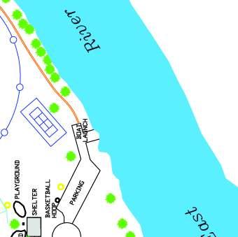
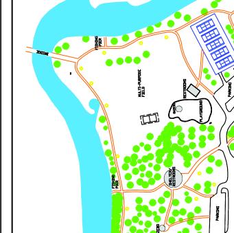
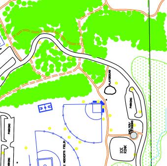
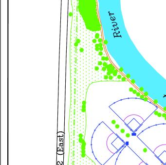
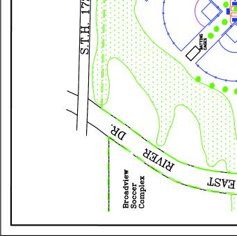
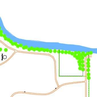
17 Inventory of Village of Allouez Parks, Trails and Facilities Open Space Facilities Allouez Optimist Kayakers Point provides access to the Fox River for canoeists and kayakers. The small parcel is located at the end of Lazarre Avenue in the right-of-way. On-street parking is available for recreational users. The parcel is not yet fully developed. Broadview Soccer Complex is a sports complex purchased from the Green Bay School District in 1987, is located in the east-central portion of Allouez. The site is located south of State Highway 172 between Libal Street and East River Drive. Recreation facilties include five soccer fields, a concession building, a picnic area, and two parking lots. In summer, recreational soccer is played on all soccer fields. The site is not yet fully developed. East Lawn Park is located in the northeastern corner of Allouez. Access to the park is from Boyd Street via Libal Street. Recreation facilities include one baseball diamond with a backstop and bleachers, one half-court basketball area, one tennis court, a playground equipment, a shelter building, a parking lot, a boat landing, a recreational trail which continues into Green Bay, and a stormwater retention pond. Babe Ruth league baseball is played at the baseball diamond during the summer months. The site is fully developed. Green Isle Park is the largest park in the Allouez park system. It is located north of Highway 172 between the East River and East River Drive. Recreation facilities include one lighted baseball diamond with a backstop and bleachers, one lighted softball diamond with a backstop and bleachers, four tennis courts, a basketball court, a soccer/football field, playground equipment, two gazebos, two pavilions (one of which is available for year-round rental), a concession stand, three storage buildings, a bridge, picnic areas with grills, four parking lots, a vita (athletic) course, nature/cross country ski trails, a canoe launch, three fishing piers, and a portion of the Resch Family East River Trail. In winter, lighted ice-skating is provided. In summer, the park supports an adult softball league, Babe Ruth league baseball, adult kickball, tennis lessons, youth football and recreational soccer. The park also provides public access to the East River, encompasses floodlands, wetlands and woodlands associated with the river. The site is not yet fully developed. Heritage Hill State Historical Park, located on the east bank of the Fox River in Allouez, was established in 1975 to interpret the early development of Green Bay and Northeast Wisconsin. Heritage Hill uses a collection of original historic buildings, some replica historic buildings and artifacts as means of interpreting the history of the area. Costumed interpreters role-play historic and everyday characters, showing what life was like in days past. The park is currently interpreting the life and customs of the time period from 1672 to There are twenty-six historic and replica interpretive structures, a visitor center, food service building and a maintenance shop. The park is comprised of approximately 48.5 acres, with over 2600 feet of frontage on the Fox River. Kiwanis Park is located in the southeastern portion of Allouez. The park supports a variety of active and passive uses. Recreation facilities include two tennis courts, one half-court basketball area, three soccer fields, playground equipment, one shelter building, a parking lot, one fishing pier, a portion of the Resch Family East River Trail, and a stormwater detention pond. In the summer, the park supports a select soccer league. The park also encompasses floodlands, 16
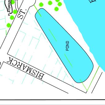
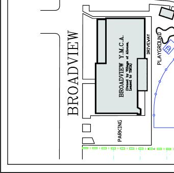
18 wetlands, and woodlands associated with the East River. Kiwanis Park is not yet fully developed. Langlade Park is located in the central portion of Allouez adjacent to Langlade Elementary School. Access to the park is provided through the YMCA and Langlade school parking lots and an easement from Terraview Drive. Recreation facilities include a softball diamond, two tennis courts, one half-court basketball area, playground equipment, a shelter building, and a picnic area. In the summer and fall, adult softball and kickball is held at the park. Park property encompasses a building that is currently leased by the YMCA. The park is fully developed. Optimist Park, purchased from the Green Bay School District in 1987, is located on the southwest corner of the intersection of East Kalb Avenue and Libal Street in the northern portion of the Village. Recreation facilities at the park include a Miracle League baseball diamond with bleachers, a shelter with concession stand, a playground, a picnic area, and a parking lot. In summer, the park supports Miracle League Baseball. The park is not yet fully developed. The Patrick Henry Martin Webster Park Sports Complex is located in the north-central portion of Allouez adjacent to Webster School. Access to the park is provided via Jourdain Lane and easements from Floral Drive, Memory Court and Brookridge Street. Recreation facilities include one football field with lights, six baseball diamonds (four with dugouts, two lighted, two with practice mounds), batting cages, two tennis courts, one half-court basketball area, playground equipment, a shelter building, a concession stand and a parking lot. In summer, youth little league and football is played at the park. In winter, a sledding hill is provided. The park is fully developed. Riverview Park is located in the eastern portion of Allouez south of Highway 172 between the East River and East River Drive. Primarily serving as a softball complex, recreation facilities include five softball diamonds with bleachers (three with dugouts), a concession building, a fishing pier, a parking lot, and a portion of the East River Trail. In the summer, girls softball is played at the park. The park is not yet fully developed. St. Francis Park is a 3.4-acre park located in the northwest portion of the village located along the shore of the Fox River. Facilities include a shelter with restrooms, picnic tables and a gazebo. St. Francis Park is the only County Park in within the Village of Allouez. Designed to serve users of the Fox River State Trail, this park is accessible only from the trail. Sunlight Park is located in the southwestern portion of Allouez. The park is located along Park Drive between Arrowhead Drive and St. Francis Drive. An easement north of the park provides access from St. Mary s Boulevard. Recreation facilities include playground equipment. The park is not yet fully developed Sunset Park is located in the southwestern portion of Allouez. The park is located between Sunset Circle and the Fox River. Access to the park is provided from Sunset Circle or the Fox River State Trail. Only passive recreation opportunities are provided at the park. On-street parking is available for park users. The park is not yet fully developed. 17
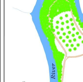
19 Wiese Family Park is located in the southeast corner of the Village. Recently acquired and developed, this park primarily services trail users and recreational soccer. Facilities include three soccer fields, two gazebos, fishing pier, nature trail, a tree nursery, a parking lot, and a portion of the Resch Family East River Trail. Access to the park is provided via Lebrun Street and the East River Trail. The park is not yet fully developed. Greenways The East River Parkway was identified and protected since the City of Green Bay s first Plan in While maintaining the name of a parkway, this open space system fits the definitional characteristics of a greenway. Greenways are an open space system in harmony with the natural environment, which typically ties park system components together to form a continuous park environment. In addition to parks within the East River Parkway, the Village owns and maintains acres of parkway in the eastern portion of Allouez. These lands have been acquired as they became available to protect the East River floodplain and wetlands for flood control. The Village maintains a system of four stormwater detention ponds within the East River Parkway, which help protect the river from pollutants. Recreational Trails The Resch Family East River Trail is a multi-purpose recreation trail located along the East River in the Village of Allouez and the Town of Bellevue. The trail initially serviced only the Village of Allouez, and has since been extended from Bellevue, thru Allouez, De Pere, Ledgeview, and eventually beyond. Approximately 2.3 miles of this trail lies within the Village of Allouez. Plans are in place to extend the trail beyond Town of Bellevue and into the City of Green Bay. Within the Village, the trail lies within the East River Parkway and serves as a recreational corridor for users. Additionally, there is discussion of establishing a trail route to connect the trail with the Fox River State Trail through the Village of Allouez. The Fox River State Trail is a 25-mile trail that runs along the eastern shore of the Fox River in Green Bay, Allouez, and De Pere and ends in the Village of Greenleaf. The trail follows the Wisconsin Central Limited Railroad corridor. The trail accommodates more trail users than any other state trail in Wisconsin. Approximately 2.9 miles of this trail lies within the Village of Allouez. There are currently three places in the village where the trail can be accessed: at the Mariner Motel, Lazarre Street, and Sunset Park. Community Recreational Facilities The Allouez Community Center is a special use facility that serves a broad range of community needs. Located on the corner of Webster Avenue and Dauphin Street, this building contains a multi-use room and a kitchen. Currently, the building supports various classes, organizational meetings, senior groups, and serves as a polling place. The Village band has an office in the building, and the room is available for rent. The Village is open to exploring uses this building can serve to accommodate various community needs. 18
20 Inventory of Public School Sites in Allouez Doty Elementary School is located in the southern portion of Allouez on the north side of Longview Avenue. Recreation facilities include a baseball diamond, two soccer fields, two halfcourt basketball areas, and two playgrounds. The school gym is used for open gym programs. Langlade Elementary School is located in the central portion of Allouez on the corner of Broadview Drive and Libal Street. Recreation facilities include a half-court basketball area and three playgrounds. The school gym is used for open gym programs. Webster Elementary School is located in the north-central portion of Allouez on the east side of Webster Avenue. Recreation facilities include two half-court basketball areas, a playground and a picnic area. The school gym is used for open gym programs. 19
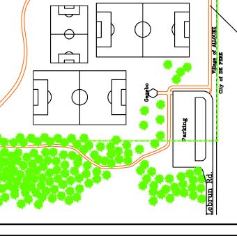
21 5. Inventory of Nearby Recreational Parks and Facilities The Village of Allouez is adjacent to five other municipalities. Although a park may be run by one municipality, it may service residents of many municipalities. This is especially true when a park is near the Village boundary, is bigger, and/or has larger service area. Nearby parks and associated amenities should influence facility needs and accessibility requirements of parks near Village borders. By considering nearby parks in park development, replication of services does not occur. Inventory of Local Parks, Trails and Facilities near Allouez Ledgeview No parks within a serviceable area Bellevue Special Use Parks Isaak Walton League Osprey Point Preserve (80 acres) East River Parkway Resch Family East River Trail Green Bay Neighborhood Parks Astor Park (8.3 acres) o horseshoes, basketball court, ball diamond, ice rink, shelter/restrooms, wading pool, tennis, volleyball Baird Place (3.6 acres) o passive recreational use, picnic area East River Emilie Park (17.2 acres) o soccer field, ball diamond, recreational trail East River Optimist Park (9.2 acres) o ball diamonds, recreational trail East River Van Beaver Park & Shelter (29.1 acres) o playground, horseshoes, ballfields, soccer field, basketball, volleyball St. James Park (2.3 acres) o bandshell, playground, basketball School-Parks Aldo Leopold School/Park o playground, basketball courts De Pere Mini-Parks Rusk Park (0.8 acres) o picnic table, small trail Neighborhood Parks Braisher Park (3.1 acres) o basketball, soccer, shelter/restrooms, playground, picnic 20
22 Community Parks Legion Park (16.0 acres) o ball diamond, basketball, ice rink, tennis courts, playground, shelter/restrooms, volleyball, swimming pool Jim Martin Park (17.2 acres) o ball diamond, basketball, soccer fields, playground, shelter/restrooms, volleyball Specialty Parks Fox Point Boat Launch (4.5 acres) o shelter/restrooms, fishing, boat launch Voyageur Park (21.7 acres) o playground, shelters/restrooms, fishing, trails East River Parkway o proposed parking, arboretum, disc golf just southeast of Wiese Family Park 21
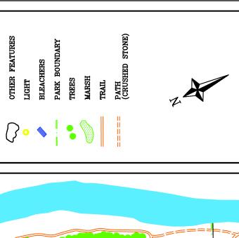
23 Map 4 Inventory of Nearby Parks and Recreational Facilities Village of Allouez Parks & School-Parks 1. East Lawn Park 2. Optimist Park 3. PHM Webster Park Sports Complex 4. Green Isle Park 5. Broadview Soccer Complex 6. Riverview Park 7. Langlade Park 8. Sunset Park 9. Sunlight Park 10. Kiwanis Park 11. Wiese Park 12. Webster Elementary School 13. St. Matthews School 14. Langlde Elementary School 15. Resurrection School 16. Doty Elementary School 17. Heritage Hill State Park E MASON ST Nearby Parks & School-Parks 18. St. James Park 19. Baird Place 20. Astor Park 21. East River Optimist Park 22. East River Emilie Park 23. East River Van Beaver Park 24. Isaak Walton League Osprey Point Preserve 25. Fox Point Boat Launch 26. St. Norbert Abbey 27. Voyageur Park 28. Braisher Park 29. Rusk Park 30. Legion Park 31. Jim Martin Park RIVERSIDE DR S WEBSTER AV 3 2 E ST JOSEPH ST 1 ALLOUEZ AV LIME KILN RD LIBAL ST 16 EAST RIVER DR 10 HOFFMAN RD STH CHICAGO ST HWY GV Legend 31 Multi-Use_Trails Schools County Lands State Lands Village Lands East River Parkway Miles Nearby_Parks.mxd - 07/09
24 6. Public Participation The primary reason for creating a Park Plan is to determine the needs of the Village s park system and prioritizing those needs. All of the needs and plans for implementation are presented in chapters 7 and 8 of this Plan. Prior to the completion of these chapters, a public open house and input session was held at the Allouez Village Hall on July 29, At this open house, a draft version of the Park Plan was presented to Village residents prior to final approval by the Village Board. Displays and kiosks were set up highlighting many of the primary components and proposals included in the Plan. The open house gave residents the opportunity to review the Plan itself and the recommendations proposed within the Plan. In addition, residents were given the opportunity to provide input on recreational programs, services and facilities prior to the completion of the Plan. In preparing the Outdoor Recreation and Open Space Plan, the Parks, Recreation and Forestry Committee held monthly meetings. All Committee meetings were open to the public, allowing residents to listen to committee reviews of the Plan and contribute associated information. A list of comments and suggestions from residents is provided below: A suggestion was made to construct a pedestrian trail through Sunset Park to link the Fox River State Trail with Sunset Circle. A suggestion was made to provide additional parking at Optimist Park to accommodate large crowds during events. A suggestion was made to provide recreational facilities that accommodate older children at Optimist Park. Various different suggestions were made by 3 different residents regarding parking at Patrick Henry Martin Webster Park Sports Complex: o Remove the northeastern ballpark and construct new parking lot to decrease the amount of parking congestion. o Define parking spots with lines o If expanding parking lot, leave a buffer of green space on the north side of lot, as existing houses are already too close. o Construct roundabouts in parking lot to slow traffic. o Pursue neighborhood input regarding the parking lot s design A suggestion was made to resurface the tennis courts at Patrick Henry Martin Webster Park Sports Complex. A suggestion was made to decrease the amount of grass surface at all parks to reduce maintenance costs. A suggestion was made to close Sunlight Park and move equipment to Sunset Park. A suggestion was made to create a band shell or amphitheater at Green Isle Park or Sunset Park. A suggestion was made to discontinue trail accesses for pets, as pet owners have been progressively abusing their privileges and bringing dogs into the parks. A suggestion was made to resurface the Resch Family East River Trail and the trails at Green Isle Park. 23
25 Recreational Needs Standards 7. Needs Assessment In recreation planning, a needs analysis is a method used to determine and quantify a community s recreational requirements. Space standards are the most widely used and common measure of a recreation system s adequacy. Total park and recreation space is normally expressed as a ratio of acres per population. Standards based on population can be useful in comparing communities and assessing current and future open space needs and demand for the community. Often, communities relate their population projections with acreage standards, to serve as a goal to maintain a consistent Level of Service (LOS). Table 3 shows a comparison of current open space standards for seven different communities in Brown County. Table 3: Comparison of Regional Communities Community Population Total Acres/1,000 Open Space Population Acreage Bellevue 11, Ashwaubenon 17, De Pere 22, Allouez 15, Green Bay 102,313 2, Howard 15, Ledgeview 5, Regional Average: 24.9 Acres per 1,000 residents Quite often, a community may meet open space standards, but still be deficient in park facilities. It is important to look at facility standards as well (see Table 4, p.25). The best guide available for use in this Plan is a set of standards developed by the National Recreation and Park Association (NRPA). These standards represent minimum goals and are not applicable to all locations universally. The NRPA now recognizes that each community has its own unique blend of social, cultural, economic, and geographic characteristics, and encourages each community to develop its own standard, or Level of Service, tailored to an appropriate quantity and quality of recreational facilities within its fiscal limits. The identification of local standards establishes a baseline for parks development and strengthens communication between the various entities that are concerned with the future of the parks system. It is useful for the Village of Allouez to compare its current park and open space inventory with the old NRPA standards to approximate the adequacy of the park system. These figures represent a legitimate goal for the Village to achieve. Typical Jurisdictional LOS Standards Recreational Lands Provided by the State acres/1,000 persons Recreational Lands Provided by the County acres/1,000 persons Recreational Lands Provided by the Local Community acres/1,000 persons Recreational Lands Provided by the Private Sector acres/1,000 persons 24
26 Table 4: Facility Level of Service Standards Facility Type NRPA standard Existing Facilities Comments Mini-Park acres per 1,000 pop. or acres <.25 mi. service area 0 acres per 1,000 pop. Minimum of.25 acres per 1,000 pop. or 3.9 acre deficit Neighborhood Park (approx acres) 1-2 acres per 1,000 pop. or acres mi. service area 3.9 acres per 1,000 pop. or 59.9 acres Minimum of 1.9 acres per 1,000 pop. or 29.3 acre surplus Community Park (approx acres) 5-8 acres per 1,000 pop. or 100 acres 1-2 mi. service area 3.5 acres per 1,000 pop. or 89.7 acres Minimum of 1.5 acres per 1,000 pop. or 10.3 acres deficit Baseball/Softball Diamond 1 per 5,000 pop. 2.9 fields per 5,000 pop fields per 5,000 pop. Football Field 1 per 20,000 pop min. travel time 1.3 fields per 20,000 pop. +.3 field per 20,000 pop. Soccer Field 1 per 2,000 pop. 1.6 fields per 2,000 pop. +.6 field per 2,000 pop. Basketball Court Tennis Court 1 per 5,000 pop. 1 per 2,000 pop. 1.6 courts per 5,000 pop. 1.4 courts per 2,000 pop. Playground 1 per 2,000 pop..8 per 2,000 pop. Volleyball Court 1 per 5,000 pop..3 per 5,000 pop. Swimming Pool Community & Recreation Center Trails 1 per 20,000 pop min travel time 0 per 20,000 pop. 1 per 25,000 pop. 1.6 per 25,000 pop..5-4 miles per 1,000 pop..5 miles per 1,000 pop. or 7.8 miles +.6 courts per 5,000 pop. surplus +.4 courts per 2,000 pop. surplus -.2 per 2,000 pop. deficit -.7 per 5,000 pop. deficit -1 per 20,000 pop. deficit. +.6 per 25,000 pop. surplus up to -3.5 miles per 1,000 pop. deficit Based on the level of service standards indicated in table 4, we are made aware of a few facility shortfalls. When we compare public open space level of service standards with other communities in Brown County (Table 3, p.24), we can see that the Village is in comparatively good standing. While the Village has a relatively limited amount of community parks and miniparks, the amount of neighborhood parks balances these deficiencies. The opportunity for additional community parks is limited due to space requirements. However, as lands are made available, the opportunities for mini-parks may be much more practical. Table 4 indicates up to four facility shortfalls. We see deficiencies in playgrounds, volleyball courts, and potentially swimming pools and trails. The Village s trail system is on the low end of the previously recommended Levels of Service provided by the NRPA. While the Village of Allouez does not harbor a public pool facility, pools in Green Bay, De Pere, and Ashwaubenon adequately service Village residents within the recommended 15 to 30 minutes of travel time. 25
27 Map 5 Service Area Analysis Legend Mini Parks (1/4 mi. service area) 1. Rusk Park Neighborhood Parks (1/2 mile service area) 2. St. James Park 3. Baird Place 4. Astor Park 5. East River Optimist Park 6. East River Emilie Park 7. East River Van Beaver Park 8. East Lawn Park 9. Optimist Park 10. PHM Webster Park Sports Complex 11. Langlade Park 12. Sunset Park 13. Sunlight Park 14. Wiese Family Park 15. Braisher Park Community Parks (1 mile service area) 16. Green Isle Park 17. Kiwanis Park 18. Legion Park 19. Jim Martin Park Miles Service_Area_Analysis.mxd - 07/09
28 Service Area Analysis In addition to the population based standards discussed above, it can be useful to analyze a community s recreational needs according to service areas. This can be done for both open space needs and for facility needs. For instance, the service area for a swimming pool is likely to be larger than that of a playground. Each park and facility type will serve a geographical area of a certain radius. A drawback to this type of standard is that it does not take into account citizen preferences and barriers resulting from the natural and man-made physical landscape. The classification of a park (i.e. mini-park, neighborhood park, community park) is typically dictated by both acreages and facilities available. Therefore, service area analyses are most typically calculated based on park classifications. Since a park s service area crosses municipal boundaries, it is useful to show service areas of nearby parks in adjacent communities. Map 5 (p.26) is a representation of service areas of Village and nearby park locations. This map shows adequate coverage of the majority of the village. We can see that two particular facility shortfalls exist in the western and northwestern portions of the Village. Due to the limited amount of vacant developable land left near these areas of the Village, the size of, and facilities to be provided at, the proposed site may be constrained. As a result, it will become crucial that any park developed in these areas maximize its usefulness through proper location, design and development. Recommendations of the Previous Allouez Park Plan Table 5 (p.28) presents a summary of the recommendations of the Village of Allouez Outdoor Recreation and Open Space Plan, prepared in 1999 by the Brown County Planning Commission. Projects since the adoption of the previous Plan are also noted. In addition, the current status of those recommendations is also noted. Projects not completed from the previous Plan offer a good base for this Plan s needs assessment. 27
29 Table 5: Recommendations and Actions since the Previous Plan Recommendation Status of Implementation Proposed Open Space Site A: It is recommended that a new park is to be acquired in the northwestern portion of the village Proposed Open Space Site B: Acquire the 30 acres of vacant land located in the southeast corner of the Village for a park and trail Wisconsin Central LTD Railroad Acquisition Proposed Lebrun/Fox Point Trail Construct footbridge connecting Bellevue and Allouez at Green Isle Park Widen East River Trail to 10 feet*/resurface trail/addition of grassed shoulders/relocation of the trail further from the river where the trail skirts the riverbank. Streambank stabilization of the East River Acquire/seek easement on remaining 4 acres (9 parcels) of private land for a trail between East Lawn Park and Green Isle Park. Pave existing parking lot and provide additional parking at Broadview Soccer Complex Resurface service road/expand maintenance building at Green Isle Park Resurface park entrance/resurface road/add parking at Patrick Henry Martin Webster Park Sports Complex Develop playgrounds at Broadview Soccer Complex, East Lawn, Green Isle, Kiwanis, Langlade, and Patrick Henry Martin Webster Park Sports Complex Add concession stand/shelters at Optimist and Green Isle Parks Add curb and gutter to Green Isle Park entrance Develop soccer field at Kiwanis Park Add batting cages, practice mound, and ballfield lighting/refurbish ballfield and bleachers at Riverview Park Add shelter at Optimist Park Refurbish shelters at Langlade, East Lawn, and Webster Parks Resurface tennis courts at East Lawn, Green Isle, Kiwanis, Langlade, and Patrick Henry Martin Webster Park Sports Complex Resurface basketball court at Green Isle Park Refurbish ballfield, construct football field, install batting cages/practice mounds, and install lighting at Patrick Henry Martin Webster Park Sports Complex Install annual/perennial beds at all parks except Broadview and Langlade Acquisition of riverfront property in southwest portion of Sunset Park Not completed Completed Not completed Not completed Completed Partially completed. Grassed shoulders were added throughout the trail. Trail still needs widening in certain areas Ongoing Ongoing Not completed Completed Not completed Partially completed. Playgrounds or updates still needed at Broadview Soccer Complex and Langlade Park Completed Not completed Completed Partially completed. Ballfield lighting still needed Completed Not completed Partially completed. Resurfacing still needed at East Lawn Park and Patrick Henry Martin Webster Park Sports Complex Completed Completed Not completed Completed Construct detention ponds in East Lawn Park, and Completed the west ends of Longview Ave. & St. Joseph St. *The American Association of State Highway Transportation Officials recommends that multi-use trails be a minimum of 10 feet wide if peak use approximates 100 users per hour. 28
30 Summary of Facility Needs Table 7 presents a compilation of the suggestions and recommendations of Village Staff, residents and the Parks, Recreation and Forestry Committee: Table 7: Site Needs Site Allouez Community Center Broadview Soccer Complex Eastlawn Park East River Parkway/Resch Family East River Trail Fox River State Trail Green Isle Park Kiwanis Park Langlade Park Patrick Henry Martin Webster Park Sports Complex Riverview Park Sunlight Park Sunset Park Wiese Park Needs Architectural and engineering review of remodeling/expansion potential to evaluate opportunities and potential constraints Provide additional and pave existing parking areas, add playground, renovate existing fields Refurbish shelter, resurface tennis court, renovate boat launch Establish an east-west trail to connect with the Fox River State Trail, acquire lands or easements along East River between East Lawn Park and Green Isle Park, add mileage markers along trail, resurface/widen trail where deficient, construct trail to link with the Heritage Village Shop along Hoffman Road, streambank stabilization, construct footbridges over East River Acquire land or easements when possible, Construct restroom facility Renovate existing canoe launch, resurface trails, add additional playground, curb and gutter both entrances, identify trees/shrubs/flowers with signs Provide additional parking areas, renovate existing playground equipment Refurbish shelter Resurface walkways/tennis courts, bury overhead power lines, provide additional and renovate existing parking lot, refurbish existing shelter, resurface park entrance and road Provide additional parking, install ballfield lighting Additional landscaping, basketball?, tennis? Install path to access Fox River State Trail, design/install riverfront parcel in southwest corner Construct footbridge across East River to connect with the Isaak Walton League Osprey Point Preserve The Village of Allouez Parks, Recreation and Forestry Department has established a practice of notifying property owners along the East River of the Village s interest in acquiring additional lands for the Resch Family East River Trail. Other undeveloped lands in Allouez lie in the western portion of the Village, where our service area analysis has indicated a need (see map 5, p.26). The Village of Allouez should continue to make efforts to secure open space lands in or near these areas should they be made available. 29
31 8. Recommendations This chapter builds upon the Needs Assessment in Chapter 7, and recommends a series of actions to improve and expand the Village s parks, recreation, trails, and open space system. The goals outlined in Chapter 3 have been used as a basis for many of the recommendations in this section. Those principles are specifically adopted as part of this master plan, and form the foundation for future decisions. Many of the recommendations in this chapter address actions to be carried out over the life of this master plan, which covers the next 5 to 10 years. However, a plan s vision is meant to be span a period of 20 years. Therefore, it is assumed that many of these recommendations will not be carried out prior to the implementation of the next Outdoor Recreation and Open Space Plan. In that event, such projects would provide a good baseline for the next round of capital improvements for the Village s Park, Recreation and Open Space System. It is important to note that this is simply a plan, as various opportunities arise expectedly or unexpectedly. All opportunities should be weighed against available resources and competing interests. Knowing that outside influences may occur, it is important to note that these recommendations are flexible. Site Acquisitions Proposed Acquire and Develop Open Space Site Based on recommendations from the previous Outdoor Recreation and Open Space Plan as well as the service area analysis, it is proposed that a new park or open space site be provided in the western or northwestern portion of the Village. Should land become available, and should local residents and the Village Board agree, it is proposed that the site be developed in such a manner as to address at least the neighborhood recreational needs of the local residents. If such an opportunity should present itself, the Village should seek a partnership with the state regarding the development of a portion of the western portion of Heritage Hill State Historical Park. Wisconsin Central LTD Railroad Trail Acquisition To provide trail continuity between the Fox and East River Trails and beyond, it is proposed that the Wisconsin Central LTD Railroad corridor be acquired for recreational trail purposes upon its abandonment. The conversion of this railroad corridor into a recreational trail will provide a link between the Fox and East River Trails and beyond. It is also envisioned that construction of special access points may be necessary for connection of this trail to the Fox and East River Trails, based on a study conducted by the Brown County Planning Commission. Lebrun/Fox Point Trail Acquisition To facilitate access between the Fox and East River Trails, and between Wiese Family Park and the Fox Point Boat Launch, it is proposed that a combination bike route/trail be developed. East River Parkway/Resch Family East River Trail Acquisitions To provide flood protection, natural resource preservation, and parkway and trail continuity, it is proposed that the Village acquire or pursue easements on the remaining riverside parcels (or roughly 5.79 acres) between Green Isle Park and East Lawn Park. These lands and homes are located within or immediately adjacent to the East River floodway. Such actions can be taken to prevent costly property damage in the event of a major flood, and would facilitate the use of these areas for parkway and trail purposes. 30
32 Proposals for Existing Park Sites Allouez Community Center It is proposed to administer engineering and feasibility studies to explore the building s potential for an eventual renovation or expansion of the facility. Broadview Soccer Complex It is proposed to renovate the existing parking lot, construct a playground, and renovate the existing soccerfields. Green Isle Park It is proposed to reconstruct the existing paved trails throughout the park, add a curb and gutters to the park entrances, and construct a playground in the southern portion of the park. Kiwanis Park Concurrent with the construction of a detention pond north of the park, it is proposed to add additional parking and move and/or upgrade existing playground equipment. In addition, a disc golf course is proposed in the southern portion of the park and/or on adjoining Village-owned lands. Patrick Henry Martin Webster Park Sports Complex It is proposed to renovate the existing parking lot. East River Parkway/Resch Family East River Trail It is proposed that the existing trail be rehabilitated and widened to 10 feet with locational markers throughout the Village. It is also proposed that a pedestrian footbridge over the East River be constructed to improve accessibility. Riverview Park Concurrent with the proposed construction of detention pond, it is proposed that additional parking be developed Sunset Park It is proposed that a pedestrian trail be constructed to connect Sunset Circle with the Fox River State Trail. It is also proposed that the recently acquired portion of Sunset Park be developed. Wiese Family Park A disc golf course mentioned above may be developed on Wiese Park and/or adjoining Villageowned lands. 31
33 Community-Wide Recommendations It is proposed that the Village s park and open space sites be maintained at essentially their current level and use. Such maintenance would consist of repair or replacement of damaged or unsafe facilities, replacement of facilities to meet implementation of the Americans with Disabilities Act, implementation of the recommendations of Village staff and the public, and implementation of any recommendations consistently encountered in the various plans referenced in the previous chapter. Upgrade all necessary facilities to replace damaged or unsafe equipment and comply with ADA standards Resurface all tennis courts, basketball courts, etc. on an as needed basis to maintain the play area in a safe condition Refurbish all baseball and softball fields on an as needed basis to repair/replace damaged equipment Refurbish all pavilions, shelters, restrooms, etc. on an as needed basis to repair/replace damaged equipment Consider expanding current shelter and pavilion rentals to serve resident needs and provide an additional source of revenue for the Village Maintain all picnic areas and provide adequate picnic tables, benches and/or grills Provide additional landscaping at all sites, particularly around park entrances/signs, picnic areas and trail rest stops Reduce erosion of, and stabilize if necessary, the banks of the East River. Particular focus should be placed upon those areas of severe erosion or instability adjacent to existing development or facilities Provide adequate signage for all parks and facilities Capital Improvements This following section provides cost estimations for many of the proposals above. It should be noted that the following costs are estimates based projects previously completed within the Village, or surrounding communities. It can also be noted that these costs are intended to represent costs of capital improvements, not routine maintenance. Capital improvements are typically designated and funded individually through segregated municipal funds and are typically projects with a high cost. Routine maintenance is traditionally funded through a park department s operations budget and is not included within this report. These estimates are based on 2009 costs and do not reflect future price changes. These cost estimates do not take into account potential funding sources, as many of these projects would be eligible for various types of funding sources. 32
34 Proposed Open Space Site Acquire site (1-3 acres minimum) $5,000 Site preparation/landscaping $28,000 Construct paths $3,000 Construct road/parking lot (10,000 s.f.) $15,000 Develop playground $30,000 East River Parkway/Resch Family East River Trail Acquire parcels/obtain easements (5.79 acres) $1,600,000 Construct footbridge $100,000 Widen/reconstruct trail (2.91 mi. x 3.3 yds.) $900,000 Locational markers along trail $5,000 Allouez Community Center Engineering/feaseability study $12,000 Broadview Soccer Complex Renovate parking lot (10,000 s.f.) $15,000 Construct playground $10,000 Renovate soccer fields (5 fields) $400,000 Green Isle Park Reconstruct trail (1/2 mile x 2 yards) $20,000 Curb and gutter entrance (700 l.f.) $10,000 Construct playground $10,000 Kiwanis Park Provide additional parking (10,000 s.f.) $15,000 Move & upgrade existing playground $30,000 Disc golf course (9 holes) $13,500 PHM Webster Park Sports Complex Renovate Parking lot $20,000 Riverview Park Provide additional parking (10,000 s.f.) $15,000 Sunset Park Develop SW portion of park $5,000 Construct trail $10,000 33
35 9. Parks and Recreation Funding Opportunities Some of the recommendations in this Plan may be implemented with the help of various sources of funds other than local property taxes. Funding sources are available in a variety of forms such as bonds, donations, federal and state grants, and loans. The Village may be eligible for various federal and state-sponsored grant programs. Each grant program has its own set of guidelines regarding eligibility of projects, and should be reviewed before applications are submitted. Grant programs are typically variable on a year to year basis, depending on the sources of funding. In addition to the following programs, the State of Wisconsin Department of Administration maintains the Wisconsin Catalog of Community Assistance (WCCA), which provides a comprehensive list of state aid programs. The WCCA can be found at Grant Programs Acquisition and Development of Local Parks (ADLP) Grants are available for acquisition or development of public, nature-based outdoor recreation areas, easements, and facilities. Allocation is provided on a DNR-regional basis. The application deadline is May 1 st each year, and $4 million is available each year with a 50% match by the local municipality. Administered by the Wisconsin Department of Natural Resources. Land and Water Conservation Fund (LWCF) Grants are available for acquisition or development of public outdoor recreation areas and facilities. The application deadline is May 1 st each year, with a 50% match by the local municipality. Administered by Wisconsin Department of Natural Resources and TEA-21. Urban Green Space Program (UGS) Grants available for land acquisition and to provide natural space within or near urban areas, or to protect scenic or ecological features including noncommercial gardening. The application deadline is May 1 st each year, and $1.6 million is available each year with a 50% match by the local municipality. Administered by the Wisconsin Department of Natural Resources. Urban Rivers Grant Program (UR) Grants are available to acquire lands and/or easements, to develop shoreline enhancements on or adjacent to urban rivers. Program is primarily designed for the purpose of preserving or restoring rivers for economic revitalization and nature-based outdoor recreation activities. The application deadline is May 1 st each year, and $1.6 million available each year with a 50% match by the local municipality. Administered by the Wisconsin Department of Natural Resources. National Recreational Trails Act (RTA) Grants are available to provide funds for maintenance, development, rehabilitation, and acquisition of land for motorized, non-motorized, and diversified trails and trail-related facilities. Awards are based on gas-tax funds on fuel used by off-highway vehicles. The application deadline is May 1 st each year, with 50% match by local municipality. Administered by Wisconsin Department of Natural Resources and TEA
36 Wisconsin Coastal Management Program (WCMP) Funds are provided to help restore, preserve, protect and enhance areas in Wisconsin s Coastal Zone. This includes locations within the counties adjacent to Lakes Superior and Michigan. The grant may also be applied toward some environmental and redevelopment expenses. One local project this program funded was educational signage along the Fox River State Trail. The application deadline is November of each year, and $1.5 million is available each year. Administered by the Wisconsin Department of Administration. Acquisition of Development Rights Grants are available to acquire development rights for nature-based outdoor recreation areas and facilities, and often easements. Typically funded where restrictions on residential, industrial, or commercial development exist. The application deadline is May 1 st each year, and $800,000 is available each year, with a 50% match by the local municipality. Transportation Enhancements Program This program provides facilities for pedestrians and bicyclists. In addition, this program provides funding for rehabilitating and operating historic transportation buildings and structures, restoring railway depots, as well as streetscaping Main Streets and landscaping near transportation facilities. There is a 20% match by the local municipality. Administered by the Wisconsin Department of Transportation and TEA-21. Part of the Statewide Multi-modal Improvement Program (SMIP) Surface Transportation Program This program provides flexible funds, which can be spent on a wide variety of projects, including roadway projects through the Federal-aid highway system, bridges, transit facilities, and bicycle and pedestrian facilities. There is a 20% match by the local municipality. Administered by the Wisconsin Department of Transportation and TEA-21. The Urban and Community Forestry Grant Program Funding is available to local units of government and nonprofit organizations for urban forestry activities. Eligible activities include development of an urban forestry Plan or urban open space program, development of a tree ordinance, development of a public awareness program, conducting street tree inventories, and tree planting and maintenance. Funds are limited to $25,000 per project with a 50% match by the local municipality. Administered by the Wisconsin Department of Natural Resources. The River Protection Grant Program This program is intended to protect or improve rivers and natural river ecosystems, including water quality, fisheries habitat, and natural beauty. $300,000 is distributed annually statewide. It is administered by the Wisconsin Department of Natural Resources. The program includes the following two subprograms: 1. River Planning Grants This program provides grants of up to 75% of overall project costs to county and local units of government, nonprofit conservation organizations, and qualified river management organizations. Eligible activities include river organization development, educational efforts, assessments of water quality and aquatic life, and non-point source evaluations. Reimbursement is limited to $10,000 per project. The application deadline is May 1 of each year. 35
37 2. River Management Grants This program provides grants of up to 75% to county and local units of government, nonprofit conservation organizations, and qualified river management organizations. Eligible activities include purchase of land or easements, development of local ordinances, and restoration of in-stream or shoreland habitat. Reimbursement is limited to $50,000 per project. The application deadline is May 1 of each year. Recreational Boating Facilities Funds are available for the construction of capital improvements to provide safe recreational boating facilities. Cost sharing is provided up to 50% for feasibility studies, construction costs, and certain types of acquisition costs. An additional 10% may be available if a municipality conducts a boating safety enforcement and education program approved by the Department. 36
38 Appendix 37
39
40

41
42
43
44
45
46
47
48
49
Outdoor Recreation Facilities Inventory
 Outdoor Recreation Facilities Inventory Allouez Neighborhood Parks: East Lawn Park (4.90 acres) is located in the northeastern corner of Allouez near Boyd Street. This site contains: Baseball diamond with
PARTF Scoring System for Grants
 PARTF Scoring System for Grants The members of the N.C. Parks and Recreation Authority use the PARTF scoring system as one of several tools to select grant recipients. Please provide all of the information
1. Parks & Recreation Neighborhood Parks Community Parks Special Use Sites 2. Open Space 3. Trails
 Appendix A: Park Classifications The intent of parks and recreation classifications is to aid in making acquisition and design decisions for park sites, facilities and the organization of recreation space
Provide and maintain sufficient public parks, recreation facilities, and open space to meet the recreational needs of County residents and visitors.
 (ROS) Goal Provide and maintain sufficient public parks, recreation facilities, and open space to meet the recreational needs of County residents and visitors. OBJECTIVE ROS.01 The County shall acquire,
PARKS & RECREATION SUBCOMMITTEE. Oct. 1, 2015
 PARKS & RECREATION SUBCOMMITTEE Oct. 1, 2015 1999 Bond - $22,000,000 Land Acquisition Allen Station Phase II Neighborhood Parks PREVIOUS BOND ELECTIONS 1999 & 2007 2002 Bond - $4,000,000 Allen Senior Recreation
Courthouse Planning Area
 Courthouse Planning Area Current Reality The Courthouse Planning Area is the characterized by expansive suburbanscale residential areas as well as the community resource planned area of athletic, educational,
Section 3 INVENTORY OF RECREATION LAND AND FACILITIES
 Photo of Juan Bautista de Anza Park Section 3 INVENTORY OF RECREATION LAND AND FACILITIES Summary of Findings Park Definitions Summary of Recreation Facilities Other Recreation Facilities Nearby Recreation
PARKS. Chapter Introduction
 Chapter 4. PARKS 4.1. Introduction This Parks Element of the 2016 Comprehensive Plan Update provides direction and guidance, based on citizen input, in order to improve and maintain the City s existing
Mendota Heights 2040 Comprehensive Plan Draft Vers
 4 Parks and Trails The City of Mendota Heights boasts a variety of recreational and open space opportunities. Few cities can claim access to regional trails, riverside and lakeside parks, scenic bluffs
Support the implementation of Cape Coral's Comprehensive Plan. Protect and utilize the unique natural resources in the City.
 7.0 OVERVIEW - RECOMMENDATIONS Chapter 7 The preparation of the Cape Coral Parks and Recreation Master Plan spanned a period of approximately 12 months. Plan preparation included the input of a wide range
3. VISION AND GOALS. Vision Statement. Goals, Objectives and Policies
 Vision Statement Queen Creek s interconnected network of parks, trails, open spaces and recreation opportunities provide safe and diverse activities and programs that sustain its unique, small town, equestrian
Southeast Quadrant Plan
 Southeast Quadrant Plan Southeast Quadrant Distinctive Features Land Use The Southeast Quadrant includes all the area within the planning area that is east of Interstate 5 and south of State Route 44.
Little Neck Planning Area
 Little Neck Planning Area Current Reality The Little Neck Planning Area is characterized by established residential neighborhoods, Town Center and Pembroke. The Eastern and Western Branches of the Lynnhaven
Arlington, Virginia is a worldclass
 EXECUTIVE S U M M A RY Arlington maintains a rich variety of stable neighborhoods, quality schools and enlightened land use policies, and received the Environmental Protection Agency s highest award for
PARKS AND RECREATION
 PARKS AND RECREATION WHAT YOU WILL FIND IN THIS CHAPTER: Background information on the development of the Park, Recreation, and System Plan (PRSP). General overview of Ellensburg s parks and recreation
City of Naples Parks Master Plan (Draft)
") City of Naples (Draft) CSAB April 12, 2016 OVERVIEW Presentation Outline Overview Needs Assessment Recap Response to Needs Implementation Strategy Questions, Discussion Preserving Naples: A vision plan
City of Naples (Draft) CSAB April 12, 2016 OVERVIEW Presentation Outline Overview Needs Assessment Recap Response to Needs Implementation Strategy Questions, Discussion Preserving Naples: A vision plan
APPENDIX D: PARKS AND RECREATION ACTION PLAN
 APPENDIX D: PARKS AND RECREATION ACTION PLAN Goals The following goals are specific to the development, maintenance, and operation of the existing parks in the Township, as well as the acquisition and
Northeast Quadrant Plan
 Northeast Quadrant Plan Northeast Quadrant Distinctive Features Land Use The Northeast Quadrant includes all the area within the planning area that is east of Interstate 5 and to the north of State Route
RECREATION AND OPEN SPACE ELEMENT GOALS, OBJECTIVES, AND POLICIES
 RECREATION AND OPEN SPACE ELEMENT GOALS, OBJECTIVES, AND POLICIES Goal 7 To provide park facilities, recreation programs, and open space resources that are safe, adequate, and accessible to all City residents,
SEWRPC OUTDOOR RECREATION AND OPEN SPACE PLANNING OBJECTIVES, PRINCIPLES, AND STANDARDS
 SEWRPC OUTDOOR RECREATION AND OPEN SPACE PLANNING OBJECTIVES, S, AND STANDARDS Introduction The Southeastern Wisconsin Regional Planning Commission (SEWRPC), as part of the regional park and open space
a) Inventory of all existing privately-owned, state-owned, or local governmentowned recreational facilities and open spaces within the context area
 Inventory of all existing privately-owned, state-owned, or local governmentowned recreational facilities and open spaces within the context area") 8.0 RECREATION AND OPEN SPACE ELEMENT (1) DATA REQUIREMENTS a) Inventory of all existing privately-owned, state-owned, or local governmentowned recreational facilities and open spaces within the context
8.0 RECREATION AND OPEN SPACE ELEMENT (1) DATA REQUIREMENTS a) Inventory of all existing privately-owned, state-owned, or local governmentowned recreational facilities and open spaces within the context
Land Use. Chapter 8: Introduction. Land Use Vision. Section I: Current Land Use 8-1
 Introduction Land use is the defining element of the comprehensive plan. It will serve as a framework for decision makers, guiding future growth and development in the Town of Oconto Falls. This chapter
RECREATION AND OPEN SPACE ELEMENT
 RECREATION AND OPEN SPACE ELEMENT Last amended August 19, 2008 Table of Contents Objective Page 5.1 Park system defined... 5-1 5.2 Access to parks and recreational facilities... 5-2 5.3 Recreation and
The urban parks in Charlottesville include Jackson Park, Lee Park, and McGuffey Park.
 Park Classifications Charlottesville s parks can be grouped into 4 different classifications: urban parks, neighborhood parks, community parks, and regional parks. Figure 1 on page 5 inventories the facilities
STAFF RECOMMENDATION: Adopt the Parks and Recreation Master Plan 2013, or take other action as deemed appropriate.
 Regular 7. CITY COUNCIL AGENDA Meeting Date: 12/02/2013 TITLE: Parks and Recreation Master Plan 2013 Adoption Proposal - Dwight Curtis Responsible Staff: Dwight Curtis Backup Material: Backup material
SECTION 4 OPEN SPACE ELEMENT
 Open Space Element SECTION 4 OPEN SPACE ELEMENT c 4.1 INTRODUCTION 4.1.1 SCOPE OF ELEMENT The state requires every general plan to have an open space element Section 65302{e». The open space element must
Chapter 6. Overall Vision RECOMMENDATIONS. More Trail and Trail. Connections. Equal Access to Park. Facilities and Programs. Water Access.
 Overall Vision More Trail and Trail Connections Equal Access to Park Facilities and Programs Water Access Environment Variety Chapter 6 RECOMMENDATIONS Chapter 6 The following recommendations for park,
City Council March 27, Parks, Recreation, and Trails Master Plan
 City Council March 27, 2018 Parks, Recreation, and Trails Master Plan Planning Process Develop Goals and Objectives Inventory of Areas and Facilities Needs Assessment And Identification Public Participation
Kempsville Planning Area
 Kempsville Planning Area Current Reality The Kempsville Planning Area is by far the most populated planning area in the City. The preservation of the 1,422 Stumpy Lake Natural Area, the largest City-owned
RECREATION, OPEN SPACE AND GREENWAYS ELEMENT GOALS, OBJECTIVES, AND POLICIES
 RECREATION, OPEN SPACE AND GREENWAYS ELEMENT GOALS, OBJECTIVES, AND POLICIES GOAL R-1: DEVELOP A RECREATION, OPEN SPACE AND GREENWAYS SYSTEM AS AN INTEGRAL COMPONENT OF AN OVERALL, COUNTY-WIDE ECONOMIC
Town of Peru Comprehensive Plan Executive Summary
 Town of Peru Comprehensive Plan Executive Communities that plan grow by choice, not by chance. A plan makes growth thoughtful, understandable, and predictable. A plan shows that a community is managing
A LONG RANGE PLAN FOR PARKS AND OPEN SPACES
 A LONG RANGE PLAN FOR PARKS AND OPEN SPACES Town of Lisbon Park Committee Waukesha County, Wisconsin 1 Ver. 2.1 May 2017 A LONG RANGE PLAN FOR PARKS AND OPEN SPACE TOWN of LISBON WAUKESHA COUNTY, WISCONSIN
Great Neck Planning Area
 Great Neck Planning Area Current Reality The Great Neck Planning area is characterized primarily by large lot/lowdensity residential development with the majority of recreational opportunity existing as
Corridor Vision. 1Pursue Minnehaha-Hiawatha Community Works Project. Mission of Hennepin County Community Works Program
 1Pursue Minnehaha-Hiawatha Community Works Project Minnehaha-Hiawatha Community Works is a project within the Hennepin Community Works (HCW) program. The mission of the HCW program is to enhance how the
Comprehensive Plan ADOPTED APRIL 2014
 Comprehensive Plan ADOPTED APRIL 2014 8 8. Outstanding Recreational & Cultural Opportunities We are proud of our community s parks and recreation system. Our community will ensure that the legacy of our
Appendix A. Park Land Definitions
 Appendix A Park Land Definitions Mini Park May serve specific function for any and all ages, depending on need of the user area. Size range 1-5 acres with optimum size being 3 acres. Service area is sub-neighborhood
This page intentionally blank.
 This page intentionally blank. Parks, Recreation, and Open Space Chapter Relationship to Vision Vision Parks, Recreation and Open Space Chapter Concepts County Government. County government that is accountable
Open Space and Recreational Facilities
 Chapter 5: Open Space and Recreational Facilities A. INTRODUCTION According to the guidelines of the 2001 New York City Environmental Quality Review (CEQR) Technical Manual, an open space analysis is necessary
SCHOOLS, PARKS AND TRAILS
 Schools, Parks, and Trails Page 1 of 12 SCHOOLS, PARKS AND TRAILS BACKGROUND Public Schools in the Clifton-Fruitvale Community include Clifton Elementary, Rocky Mountain Elementary, Grand Mesa Middle,
Parks, and Recreation & Cultural Arts Master Plan Update
 Parks, and Recreation & Cultural Arts Master Plan Update Community Profile Public Input Summary: Staff Interviews conducted April 14 and 15, 2014 Citizens Workshop - conducted April 15 th and 24 th, May
OPEN SPACE CHAPTER 7: OVERVIEW. Preserve open space to protect natural resources, enhance character and provide passive recreation opportunities
 CHAPTER 7: OPEN SPACE OVERVIEW Ridgefield has made tremendous progress permanently preserving areas of town as open space. Open space preservation can serve many important purposes, including: protect
Neighborhood Districts
 NEIGHBORHOOD DISTRICTS SEVEN MAIN DISTRICTS Neighborhood Districts While the Development Plan provides a broad-scale overview of the neighborhood, this section focuses on uses and relationships at the
CHAPTER 9: Parks, Recreation, and Open Space Element
 CHAPTER 9: Parks, Recreation, and Open Space Element INTRODUCTION: The Parks, Recreation, and Open Space Element is a comprehensive representation of the City s vision and goals for the future of the park,
Chapter 10 IMPLEMENTATION RECOMMENDATIONS
 Chapter 10 IMPLEMENTATION RECOMMENDATIONS The recommended land use plan presented in the previous chapter provides a design for the attainment of the urban and rural development and open space preservation
Town of Jamestown. Parks and Recreation Master Plan for Jamestown Park
 Town of Jamestown Parks and Recreation Master Plan for Jamestown Park Adopted December 16, 2014 Acknowledgements Town Council Keith Volz, Mayor Brock Thomas Lynn Montgomery Georgia Nixon-Roney William
APPENDIX D2: PARKS AND TRAILS
 APPENDIX D2: PARKS AND TRAILS Cultivate Hopkins Comprehensive Plan 8/15/18 DRAFT Cultivate Hopkins Appendix D2 1 Existing Conditions Local Parks and Trails Figure D2.1 shows the existing park and trail
PIERCE COUNTY IMPACT FEE WORKING GROUP. Pierce County s Park System
 PIERCE COUNTY IMPACT FEE WORKING GROUP Pierce County s Park System Project Title 2/25/2016 1 Pierce County s Park System Park System Concept Park Classifications Current Park Inventory Park System Comparison
Element 0X Parks, Recreation and Open Space
 Element 0X Parks, Recreation and Open Space Table of Contents 1. Introduction 2. Major Issues, Concerns, and Citizen Input 3. Parks, Recreation and Open Space Goals & Policies 4. Analysis Background and
The following principles guide the development of goals and strategies to protect and promote these amenities:
 OPEN SPACE/PARKS/TRAILS/RECREATION GOALS/STRATEGIES Cherry Hills Village is a living environment that offers low density development, open areas, public scenic vistas, public trails and public parks. This
Goals and Action Items
 Goals and Action Items Developing goals and action items is an important part of the recreation planning process. The overall goals of a recreation department are to provide recreation opportunities for
Appendix E Section 4(f) Evaluation
 Evaluation") Appendix E Section 4(f) Evaluation Appendix E Draft Section 4(f) Evaluation E.1 Introduction This appendix addresses a federal regulation known as Section 4(f), which protects parks, recreation areas,
Appendix E Section 4(f) Evaluation Appendix E Draft Section 4(f) Evaluation E.1 Introduction This appendix addresses a federal regulation known as Section 4(f), which protects parks, recreation areas,
Special Revenue Funds
 Special Revenue Funds Special Revenue Funds account for the proceeds of specific revenue sources (other than special assessments for major capital projects) that are legally restricted to expenditures
Pungo/Blackwater Planning Area
 Pungo/Blackwater Planning Area Current Reality The Pungo/Blackwater Planning Area represents the rural landscape and lifestyle that encompasses nearly 40% of Virginia Beach. The Agricultural Reserve Program
Chapter 11 PARKS, RECREATION AND OPEN SPACE
 Chapter 11 PARKS, RECREATION AND OPEN SPACE INTRODUCTION The 2016 Parks, Recreation and Open Space Plan (Park Plan) for Gig Harbor represents the City s vision and provides goals and objectives for the
Elm Fork Land Use. Trinity River Corridor Project Committee May 13, 2013
 Elm Fork Land Use Trinity River Corridor Project Committee May 13, 2013 Purpose Discuss Trinity River planned Land Use and Appropriate Compatible Uses, particularly with respect to the Elm Fork Area 2
Executive Summary. Parks and Recreation Plan. Executive Summary
 Parks and Recreation Plan Executive Summary The Whitemarsh Township Parks and Recreation Plan sets forth a vision for how Whitemarsh Township can provide a premiere parks and recreation system reflective
Appendix D OUTDOOR RECREATION AND OPEN SPACE PLANNING OBJECTIVES, PRINCIPLES, AND STANDARDS FOR WASHINGTON COUNTY
 Appendix D OUTDOOR RECREATION AND OPEN SPACE PLANNING OBJECTIVES, S, AND FOR WASHINGTON COUNTY OBJECTIVE NO. 1 The provision of an integrated system of public -use outdoor recreation sites and related
IMPLEMENTATION STRATEGIES. In This Chapter. Goals & Strategies 182 Project List 183 Future Land Use 186 CHAPTER 11 IMPLEMENTATION STRATEGIES
 In This Chapter Goals & Strategies 182 Project List 183 Future Land Use 186 11 IMPLEMENTATION STRATEGIES NORTH AUGUSTA, SC 2017 COMPREHENSIVE PLAN 179 Individual commitment to a group effort that is what
3.2 P - Park District
 3.2 P - Intent - The P: s are established to promote and maintain the development of recreational opportunities within the. The development of new parks or the major expansion of existing parks within
6. RECREATION AND OPEN SPACE ELEMENT
 6. RECREATION AND OPEN SPACE Introduction This Recreation and Open Space Element includes Goals, Objectives and Policies (GOP) that apply to the main campus in Gainesville and the Lake Wauburg Recreation
G. RECREATION AND OPEN SPACE ELEMENT. The following summarizes the Recreation and Open Space Element:
 G. RECREATION AND OPEN SPACE ELEMENT The purpose of the Element is to provide the framework and direction for a comprehensive system of public and private sites for recreation, including, but not limited
nokomis-hiawatha regional park master plan and park improvements
 master plan and park improvements CAC Workshop # August 26th, 2014 charge of the cac The Nokomis Hiawatha Regional Park CAC shall: Become knowledgeable about the project and its scope Understand and represent
EL DORADO COUNTY GENERAL PLAN PARKS AND RECREATION ELEMENT PRINCIPLE INTRODUCTION STATE AUTHORIZATION
 EL DORADO COUNTY GENERAL PLAN PARKS AND RECREATION ELEMENT PRINCIPLE The General Plan must identify the types of governmental services, including parks and recreation facilities, which are necessary to
GOALS AND OBJECTIVES. This section includes Goals and Objectives for the communities of:
 GOALS AND OBJECTIVES The Goals and Objectives provide the overriding ideas and thoughts regarding the planning, development and maintenance of parks and recreation facilities and recreational opportunities
Comprehensive Parks and Recreation Master Plan. Executive Summary. Submitted To: City of Milton, GA October 2012
 Comprehensive Parks and Recreation Master Plan Executive Summary Submitted To: City of Milton, GA October 2012 Executive Summary The City of Milton envisioned the need for an effective Master Planning
HAZARD MITIGATION GOALS AND OBJECTIVES
 SEWRPC Community Assistance Planning Report No. 282, 2nd Edition CITY OF MILWAUKEE ALL HAZARDS MITIGATION PLAN UPDATE Chapter IV HAZARD MITIGATION GOALS AND OBJECTIVES [NOTE: Throughout this plan update
Open Space and Recreational Resources
 Chapter 3: Open Space and Recreational Resources A. INTRODUCTION Under the 2012 City Environmental Quality Review (CEQR) Technical Manual guidelines, open space is defined as publicly accessible, publicly
Yadkin River Greenway Feasibility Study Fact Sheet Village of Clemmons, Town of Lewisville, Town of Bermuda Run
 Fact Sheet Village of Clemmons, Town of Lewisville, Town of Bermuda Run Project Background The Yadkin River Greenway Feasibility Study is a joint project with the Village of Clemmons, the Town of Bermuda
CHAPTER 1: INTRODUCTION
 CHAPTER 1: INTRODUCTION MAP OF OUTAGAMIE COUNTY, WI N 1 = 6 miles INTRODUCTION The Town and Village of Black Creek are located in central Outagamie County, Wisconsin. The Village is located in the north
City of Talent Capital Improvements Plan
 City of Talent Capital Improvements Plan Report Prepared For: City of Talent Prepared by: Community Planning Workshop Community Service Center 1209 University of Oregon Eugene, OR 97403-1209 Email: cpw@uoregon.edu
Chapter 5: Natural Resources and Environment
 NATURAL RESOURCES AND ENVIRONMENT 5-1 5 Chapter 5: Natural Resources and Environment BACKGROUND AND INTENT Urban expansion represents the greatest risk for the future degradation of existing natural areas,
CITY OF ANN ARBOR // Parks + Recreation. Hillary Hanzel Park Planner + Landscape Architect
 CITY OF ANN ARBOR // Parks + Recreation Hillary Hanzel Park Planner + Landscape Architect CITY OF ANN ARBOR // Parks + Recreation 1. Overview of Parks System 2. Recent + Upcoming Capital Projects 3. History
9. PARKS AND RECREATION
 9. PARKS AND RECREATION Goal: Create a comprehensive, maintained, and interconnected system of parks, pathways, and open spaces as well as a balanced program of recreational activities for residents of
A citizen s guide to the. Comprehensive Plan. City of Lakeville, Minnesota 1
 A citizen s guide to the Comprehensive Plan 2008 City of Lakeville, Minnesota 1 Introduction The City of Lakeville completed an update of its Comprehensive Plan in 2008. A comprehensive plan is a tool
City of Bonney Lake Allan Yorke Park. MASTER PLAN SUMMARY REPORT June 30, 2016
 City of Bonney Lake Allan Yorke Park MASTER PLAN SUMMARY REPORT June 30, 2016 TABLE OF CONTENTS INTRODUCTION PUBLIC INVOLVEMENT PROCESS MASTER PLAN North Park Central Park South Park East Park Field Development
TABLE OF CONTENTS. Tables Table UC Davis Park and Open Space Resources
 TABLE OF CONTENTS 4.13 Recreation... 4.13-1 4.13.1 Environmental Setting... 4.13-1 4.13.2 Impacts and Mitigation Measures... 4.13-4 4.13.3 References... 4.13-8 Tables Table 4.13-1 UC Davis Park and Open
SECTION FOUR: MISSION STATEMENT, GOALS & OBJECTIVES
 SECTION FOUR: MISSION STATEMENT, GOALS & OBJECTIVES Chapter Summary Chapter Ten: Mission Statement, Goals & Objectives To fulfill its mission, the Parks and Recreation Commission has identified four basic
ATTACHMENT A AERIAL PHOTO OF McINTIRE PARK EAST
 ATTACHMENT A AERIAL PHOTO OF McINTIRE PARK EAST McIntire Botanical Garden Request for Proposals Attachments Page 1 of 33 ATTACHMENT B - MEMORANDUM OF AGREEMENT WITH THE CITY OF CHARLOTTESVILLE McIntire
Review of Opportunity Area C Draft Comprehensive Plan and Draft BOS Follow-On Motions. Special Working Group Meeting March 4, 2015
 Review of Opportunity Area C Draft Comprehensive Plan and Draft BOS Follow-On Motions Special Working Group Meeting March 4, 2015 The slides that follow identify where the draft Comprehensive Plan has
RECREATION AND OPEN SPACE ELEMENT
 RECREATION AND OPEN SPACE ELEMENT TOWN OF HOWEY-IN-THE-HILLS LAKE COUNTY, FLORIDA ADOPTED ON OCTOBER 11, 2010 RECREATION AND OPEN SPACE ELEMENT TABLE OF CONTENTS A. INTRODUCTION...1 1. PURPOSE...1 B. EXISTING
DISCUSSION TOPIC: ST JOHNS RIVER & ITS TRIBUTARIES (BPII) 2030 COMPREHENSIVE PLAN POLICES AND REGULATORY FRAMEWORK
 2030 COMPREHENSIVE PLAN POLICES AND REGULATORY FRAMEWORK") DISCUSSION TOPIC: ST JOHNS RIVER & ITS TRIBUTARIES (BPII) 2030 COMPREHENSIVE PLAN POLICES AND REGULATORY FRAMEWORK St. John s River & Its Tributaries Issue Summary: The St. Johns River is an important
DISCUSSION TOPIC: ST JOHNS RIVER & ITS TRIBUTARIES (BPII) 2030 COMPREHENSIVE PLAN POLICES AND REGULATORY FRAMEWORK St. John s River & Its Tributaries Issue Summary: The St. Johns River is an important
TAO S PARKS MASTER PLAN
 TAO S PARKS MASTER PLAN December 2017 Kit Carson Park Fred aca Park Eco Park Youth + Family Center Eco Park TAOS PARKS MASTER PLAN December 2017 SCOPE OF WORK Town of Taos Parks + Recreation Master Plan
The City shall enhance and improve the accessibility of parks and recreational facilities while protecting their quality. by:
 GOALS, OBJECTIVES AND POLICIES GOAL 1: To provide open space and recreation as an essential element needed for the betterment of the City s character and quality of urban life. The City shall plan for
METROPOLITAN COUNCIL 390 North Robert Street, St. Paul, MN Phone (651) ; TDD (651)
 ; TDD (651)") DATE: December 20, 2011 METROPOLITAN COUNCIL 390 North Robert Street, St. Paul, MN 55101 Phone (651) 602-1000; TDD (651) 291-0904 TO: Metropolitan Parks and Open Space Commission FROM: Tori Dupre, Senior
DATE: December 20, 2011 METROPOLITAN COUNCIL 390 North Robert Street, St. Paul, MN 55101 Phone (651) 602-1000; TDD (651) 291-0904 TO: Metropolitan Parks and Open Space Commission FROM: Tori Dupre, Senior
Pleasant Garden Community Center MASTER PLAN
 Pleasant Garden Community Center MASTER PLAN For the Town of Pleasant Garden North Carolina February 6, 2018 Adopted 1730 Varsity Drive Raleigh, NC 27606 919.233.8091 McKim & Creed Project #07083.0004
{Best Practices. Summary of Tools, Strategies and Best Practices from 11 Michigan Case Study Communities
 Case Studies Michigan Coastal Community Working Waterfronts { Summary of Tools, Strategies and from 11 Michigan Case Study Communities Table of Contents Zoning...2 Community and Stakeholder Collaboration
OPEN SPACE, PARKS, AND HISTORIC SITES
 OPEN SPACE, PARKS, AND HISTORIC SITES The conservation of land, water, and historic resources, and the related provision of recreation opportunities, is one of the most important factors in maintaining
ADOPTED CAPITAL IMPROVEMENT PROGRAM BUDGET ARROYO PROJECTS
 ADOPTED CAPITAL IMPROVEMENT PROGRAM BUDGET ARROYO PROJECTS HAHAMONGNA FY 212-216 Capital Improvement Program Priority Description Total Estimated Costs Appropriated Through FY 211 Adopted FY 212 FY 213
Westport Master Plan. Town of Westport. Master Plan Master Plan Update Committee. Westport, Massachusetts
 Town of Westport Master Plan 2004 Master Plan Update Committee Westport, Massachusetts Open Space and Recreation 5-1 Table of Contents Table of Contents... i List of Tables... ix List of Figures... ix
Y Sports Complex PROGRAMMING Capitol Improvement Plan. Anticipated/Suggested Improvements. Sedgwick County Park: Sports Complex:
 PROJECT OVERVIEW Location: East of Ridge Road, between 21 st Street and 13 th Street, not including SCZ In conjunction with The Sedgwick County Park Facilities Observation Report Compilation of improvements
City of Mahtomedi Park System Plan Public Hearing Draft: September 13, 2006
 Chapter 6: IMPLEMENTATION INTRODUCTION Earlier chapters of this Plan analyzed existing conditions, identified park and recreation needs, and proposed park, trail, and open space recommendations. This chapter
2. Analysis. DRAFT Gerald Richards & Pleasantview Park Master Plan
 DRAFT Gerald Richards & Pleasantview Park Master Plan 19 Historic Features According to the National Register of Historic Places and the National Historic Landmarks Program, there is nothing of national
Mendota-Lebanon Hills Greenway Master Plan Executive Summary. August draft for more information visit
 Mendota-Lebanon Hills Greenway Master Plan Executive Summary August 2013 draft for more information visit www.hkgi.com/projects/dakota INTRODUCTION The Mendota-Lebanon Hills Greenway Master Plan portrays
Parks, Open Space and Trails
 Introduction Parks have often been referred as the lungs of our cities, cleansing the air of pollutants and particulate matter. Parks are also gathering places for families and community. They offer spaces
Gloucester County s Comprehensive Plan. The Community Connection
 Gloucester County s Comprehensive Plan The Community Connection Current Comp Plan Adopted in 1991 with a 20 year planning horizon Updated in 1995 with Part V- Implementation Recommendations and Appendix
10.0 Open Space and Public Realm
 10.0 Open Space and Public Realm 10.0 Open Space and Public Realm The Public Open Space System is comprised of: outdoor spaces available for public use that are either publicly owned (e.g., parks and
CHAPPLES PARK MASTER PLAN
 CHAPPLES PARK MASTER PLAN Presentation of Preliminary Development Options Public Open House #2 Wednesday November 2 nd, 2016 TONIGHT S AGENDA 1. Welcome & Introductions 2. Presentation by Sierra Planning
STEWARDSHIP OF LONG ISLAND SOUND S ECOLOGICAL AND RECREATIONAL RESOURCES
 STEWARDSHIP OF LONG ISLAND SOUND S ECOLOGICAL AND RECREATIONAL RESOURCES Robin Kriesberg, Save the Sound, Inc. Thomas Halavik, US Fish and Wildlife Service Coastal Program An Initiative to Identify, Protect
Bullhead City Rotary Park Plan Update
 Bullhead City Rotary Park Plan Update PLANNERS/LANDSCAPE ARCHITECTS: RBF Consulting 16605 N 28 th Avenue Suite 100 Phoenix, Arizona 85053-7550 (602) 467-2200 CIVIL ENGINEER: RBF Consulting 16605 N. 28
Attachment M 9. PARKS AND RECREATION 9.1 PARKS, TRAILS AND OPEN SPACE PLAN
 Attachment M 9. PARKS AND RECREATION Goal: Create a comprehensive, maintained, and interconnected system of parks, pathways, and open spaces as well as a balanced program of recreational activities for