PUDDING MILL INTRODUCTORY FLIP-BOOK. Summer Pudding Mill Square
|
|
|
- Allen Neal
- 6 years ago
- Views:
Transcription

1 PUDDING MILL INTRODUCTORY FLIP-BOOK Summer 2016 Pudding Mill Square
2 2
3 3


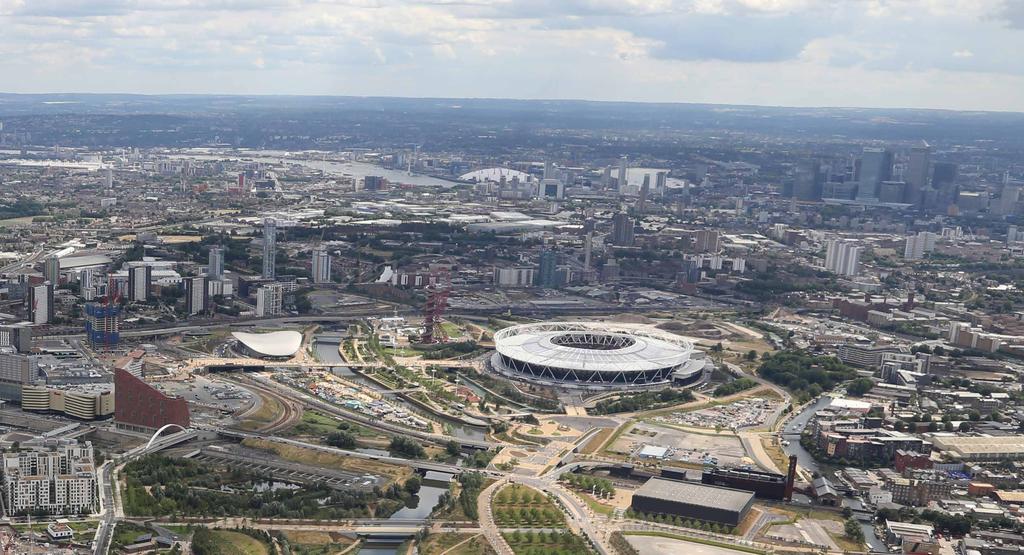
4 INTRODUCTION The Legacy Corporation is revisiting the Pudding Mill masterplan in response to the changing context of adjoining developments, including the Cultural and Education District. Pudding Mill The Legacy Corporation wants to create a vibrant Local Centre at the heart of Pudding Mill, as supported by the Local Plan, which maximises residential capacity and employment opportunities, as well as meeting key priorities around local economic benefit, equality and inclusion, sustainability and community engagement. London Aquatics Centre London Stadium 4

5 BACKGROUND - LEGACY COMMUNITIES SCHEME The Legacy Communities Scheme (LCS) planning application, which was approved in September 2012, proposed a range of employment and residential uses at Pudding Mill, as well as other supporting social infrastructure and open space. In total the scheme allowed for around 1,300 homes, plus a range of employment floorspace, retail units and community facilities. Illustrative Masterplan Produced for LCS (2012) 5
6 BRIEF AND VISION FOR PUDDING MILL The Pudding Mill masterplan aims to create a new residential neighbourhood with a vibrant Local Centre, providing a range of housing typologies to meet local need, as well as flexible employment floorspace, retail units and community facilities; all tied together through a high quality public realm. The new development will seek to improve pedestrian and cycle connections through the site and maximise on the opportunities presented by its proximity to the Pudding Mill Lane DLR station and Stratford High Street, as well as Queen Elizabeth Olympic Park. The neighbourhood will include: New homes, including sheltered accommodation Flexible employment space Retail units Social infrastructure Play space Leisure space 6

7 Illustrative Visualisation: City Mill River 7
 Landscape Architect AECOM Planning Agent & Environmental Consultant FLUID Community")
8 WHO S INVOLVED LONDON LEGACY DEVELOPMENT CORPORATION (LLDC) Landowner & Developer ALLIES & MORRISON Masterplanners BRADLEY-HOLE SCHOENAICH LANDSCAPE ARCHITECTS (BHSLA) Landscape Architect AECOM Planning Agent & Environmental Consultant FLUID Community Consultation 8
9 9
10 WHAT IS A MASTERPLAN A masterplan usually consists of a series of two dimensional plans and three dimensional images and text describing how an area will be developed. The outline planning application will set out the vision for the site as well as details of access, scale, character, use and urban design; it provides a foundation from which future Reserved Matters Applications can be prepared. The outline planning application will seek to deliver the following for Pudding Mill: EMPLOYMENT Approximately 36,000 sqm of flexible employment space that can either be used by a single tenant or by tenants, either taking entire floors or subdivided sections. RESIDENTIAL Approximately 1,500 residential homes of which 40 will be assisted living homes. RETAIL AND LEISURE FACILITIES Approximately 2,500 sqm of retail space and leisure facilities COMMUNITY FACILITIES Up to 13,142 sqm of community facilities OPEN SPACE Approximately 16,000 sqm of open space to compliment the wider provision within Queen Elizabeth Olympic Park. The masterplan will also include play space and cater for all ages. 10
11 11

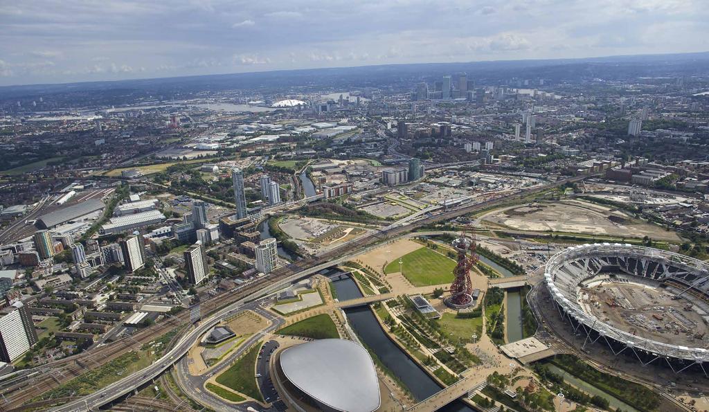
12 SITE CONTEXT Pudding Mill sits between Queen Elizabeth Olympic Park to the North and Stratford High Street to the South. Both of which are undergoing a rapid period of change. In Links folder do again to change name Pudding Mill is bounded on two sides by the Waterworks River to the northeast and Bow Back River to the southeast. To the southwest it is contained by Cooks Road, and adjoins existing allotments and the Great Eastern Railway corridor to the northeast. The City Mill River also runs through Pudding Mill, crossing beneath the Great Eastern Railway corridor at its junction with the Greenway. 12

 and High Street Stratford.")
13 SURROUNDING CONTEXT The surrounding context of Pudding Mill, which is subject to rapid change, is defined largely by the Park to the north, Warton Road and the Carpenters Estate to the east, and Stratford High Street plus the associated development at Strand East to the south. CONNECTIONS The Greenway, a strategic pedestrian and cycle route, bisects Pudding Mill and provides an important link between Stratford and Hackney, as well as routes into the Park. A network of waterways known as the Bow Back Rivers intersects with the Great Eastern Railway viaduct, Greenway (Northern Outfall Sewer) and High Street Stratford. There is the potential to expand and improve these links, particularly the Greenway, as the near-by UCL East site and Stratford Waterfront are developed. CHARACTER The site itself was formerly industrial land and is characterised by various site compounds, as well as the Bow Electricity Substation and associated utilities infrastructure that criss-cross the site. Pudding Mill DLR station is located at the junction of Marshgate Lane and Barbers Road and acts as a new gateway to the site. An allotment roughly 1 hectare in size, is located south of the railway viaduct. A cluster of residential buildings occupy a triangular piece of land between the City Mill River and Greenway, whilst a number of high rise residential towers are located to the south of the Bow Back River along Stratford High Street. Bow Back River Waterworks River 13
14 WIDER MAJOR DEVELOPMENTS WICK STRATFORD NEW TOWN 1 2 EAST WICK Summary: Up to 870 new homes, new primary school and two new nurseries Status: Zonal masterplan approved December 2015, Phase 1 detailed design in planning process Developer: London Legacy Development Corporation, East Wick and Sweetwater Projects Ltd SWEETWATER Summary: Up to 650 new homes including apartments and family homes. A new primary school, two new nurseries, community space, a library and health centre Status: Zonal masterplan to be submitted for planning approval in summer 2016 Developer: London Legacy Development Corporation, East Wick and Sweetwater Projects Ltd 6 BOBBY MOORE ACADEMY Summary: A sports specialist secondary school and primary school with a 6th form across two sites. Status: Planning applications granted Proposed operator: David Ross Education Trust 7 PUDDING MILL Summary: A residential neighbourhood that will deliver up to 1,300 homes, employment floorspace, retail units, community facilities, and a wide range of public open spaces. Status: Outline planning permission granted with amendments currently being considered by LLDC Developer: London Legacy Development Corporation CHOBHAM ACADEMY Summary: A new school for 3-18 year olds that opened in September In addition to 100 children in the nursery, when the Academy is at full capacity it will have 600 students in the primary school, a further 900 students in the secondary school and a Sixth Form for 420. Status: Now open Developer: A Lend Lease Harris Partnership CHOBHAM FARM Summary: A new family neighbourhood delivering around 1000 homes (of which over 40% are family homes), home zone streets, new public space, commercial space and community facilities. Status: Under construction Developer: LCR and East Thames Group BOW EAST Pudding Mill Site Boundary LLDC Boundary LB Hackney Boundary LB Newham Boundary LB Tower Hamlets Boundary Health Centre Education / Training Workspace Cultural / Exhibition Business Hotel / Student Housing Community Facilities Retail / Leisure Sport BROMLEY- BY-BOW N HACKNEY WICK CENTRAL Summary: Creation of a new neighbourhood centre focused around Hackney Wick Station. The new station which includes an underpass through the existing embankment will create a new north south pedestrian link. The neighbourhood centre development will consist of workspace clusters with a diverse range of spaces, retail, local amenities, and the introduction of between new homes. Status: Planning permission granted for the new station. Outline application for the Hackney Wick Neighbourhood Centre to be submitted April 2016 Developer: London Legacy Development Corporation STRATFORD WATERFRONT Summary: A new campus for UAL s London College of Fashion, along with major new spaces for the Victoria and Albert Museum and Sadler s Wells. Status: Cultural and Education District outline planning applications due to be submitted late 2016 Developer: London Legacy Development Corporation with site partners THE STADIUM Summary: From 2016 the Stadium will become the home of West Ham United, before then it will host a number of international events including the Rugby World Cup in A new community track will be open alongside the Stadium and will be home to the Newham and Essex Beagles Athletic Club. The Stadium will also become the new national centre for athletics from Status: Fully open from summer 2016 Developer: E20 Stadium LLP RICK ROBERTS WAY Summary: Provision of approx. 500 new homes as part of a mixed-use masterplan. Status: Outline planning permission granted, with secondary school relocated within PDZ3 (see no. 6) and further amendments under consideration Developer: London Legacy Development Corporation and Newham HERE EAST Summary: Transforming the former Olympic Press and Broadcast Centre an innovation centre set to provide over 1.2 million square feet of space for creative entrepreneurs and creating up to 7,500 jobs on site and in the local community. Key tenants include BT Sport, Hackney Community College, Loughborough University and Infinity SDC. Status: BT Sport already broadcast on site, fully operational by 2018 Developer: icity, a joint venture between Delancey and Infinity SDC CHOBHAM MANOR Summary: The first of the five new neighbourhoods from Including 828 new homes, 75% designed for families and 1/3 affordable homes. Shops, cafes, bars and other facilities will support a vibrant community. Status: Sales underway, first residents occupied their homes in late 2015 Developer: Chobham Manor LLP EAST VILLAGE Summary: 2,818 new homes, a new school (Chobham Academy - see point 12), a new health centre, cafés, bars, restaurants, shops and 27 acres of public space. Further developments for an additional 2,000 homes are currently in the planning process. Status: Now open Developer: Get Living London and Triathlon Homes THE INTERNATIONAL QUARTER Summary: 4 million sq ft of new workplace - TFL and the FCA confirmed as tenants. A 4 star hotel, shops, restaurants, childcare and community facilities. Up to 25,000 jobs created. Status: Construction started in 2014, first office occupation in 2017 Developer: Lend Lease and LCR GLASSHOUSE GARDENS Summary: The residential development that forms part of The International Quarter new homes looking out over the iconic buildings of the south of the Park as part of The International Quarter. Status: Final completion estimated for 2017 Developer: Lend Lease and LCR CHERRY PARK Summary: Approx 1,200 new homes alongside community facilities, restaurants, cafes and a servicing facility for Marks and Spencer. Status: Hybrid planning application submitted Developer: Stratford City Developments Ltd ANGEL LANE Summary: Unite student accommodation for 750 students, new hotel, a major apartment tower and offices. Status: Opened September 2015 Developer: Unite Group Plc STRAND EAST Summary: 1,200 homes, office spaces for a range of businesses including digital and creatives, a riverside park and a range of retail and community uses. Status: Planning permission granted Developer: Vastint UK Surrounding Area Plan showing some of the major developments in the area. (Dots do not indicate locations of facilities) 14

15 19 COOKS ROAD Summary: Up to 543 residential units, approx. 58,000 sq ft of commercial floorspace and open spaces and landscaping Status: The application for the southern block has been approved. Developer: BellwayPartnership 20 MARSHGATE Summary: 8 new buildings containing approx. 45,000 sq ft of business floorspace, 254 new homes and open space Status: Planning permission granted Developer: Workspace 15
16 OPPORTUNITIES CHARACTER AREAS The natural division of the site allows for the creation of two distinct, yet interconnected neighbourhoods: a vibrant urban neighbourhood at Pudding Mill defined by the Local Centre and a more domestic and relaxed neighbourhood at Bridgewater.. TRANSPORT CONNECTIONS The Pudding Mill DLR Station, reopened in 2014, provides direct access to Stratford Station in just 2 minutes, which acts as an interchange for various onward connections across London. Pudding Mill Bridgwater 16

17 CONNECTIVITY At present Pudding Mill is somewhat isolated, being bounded by various barriers to pedestrian or vehicular movement. The masterplan will explore opportunities to promote new or improved connections to the Park and Stratford High Street, as well as Warton Road. The masterplan will consider the hierarchy of these connections and how they should be linked to new internal routes across Pudding Mill. WATERWAYS Pudding Mill benefits from a variety of waterside with rivers surrounding it on three sides. The masterplan will provide appropriate responses to this special setting by taking into account strategic views and pedestrian movement patterns, as well as townscape considerations. 17
18 CONSTRAINTS RAILWAY VIADUCT The Great Eastern Railway/Crossrail/DLR viaduct bounds Pudding Mill to the north. Whilst the station itself will offer a degree of active frontage, the viaduct west of the station is comprised of a blank concrete wall. To the east of the station, the Marshgate Lane underpass separates vehicular and pedestrian routes by way of a significant drop in level. UNDERGROUND UTILITIES A number of underground constraints such as Power Lines Underground (PLUG), HV cables and their easements as well as utilities within existing roads impact the development of the site. 18

19 BOW ELECTRICITY SUBSTATION, Bow Electricity Substation and the new headhouses for the underground power lines are situated in the centre of Pudding Mill, on either side of Pudding Mill Lane. These enclosures form part of London s strategic infrastructure network and have specific operational constraints that need to be respected. They therefore require careful integration into the layout of the neighbourhood to avoid stretches of uninhabited frontage alongside poor quality public space. 19
20 PUDDING MILL KEY ASPIRATIONS The masterplan seeks to deliver the following: A new residential neighbourhood that provides a range of housing to meet local need A new Local Centre providing flexible employment floorspace, retail units and community facilities A high-quality environment comprising a variety of building uses and typologies A place that will engage with its immediate context in terms of form and character Taller buildings that are located to signify key locations or relationships within the masterplan, such as the arrival at Pudding Mill DLR or proximity with Stratford High Street A wide range of public open spaces, including play provision for all ages Improved pedestrian and cycle connectivity within the site, as well as new links to the Park and Stratford High Street 20

21 Illustrative Visualisation: City Mill Passage 21
22 EMERGING ILLUSTRATIVE MASTERPLAN Overview of Key Components A VIBRANT LOCAL CENTRE Create a vibrant Local Centre at the heart of Pudding Mill Provide flexible employment floorspace, retail units and various community facilities Create a new pedestrian East-West Street that will improve connections across the site to adjoining developments A DIVERSE RESIDENTIAL NEIGHBOURHOOD A network of close, intimate streets and shared spaces connecting a series of distinct public spaces with larger more formal blocks dissected by mews streets and passages. A diversity of typologies, from mews houses, to stacked maisonette, to mansion blocks to residential towers. At Bridgewater, a series of stacked maisonettes front the Greenway and the waters edge, whilst apartment blocks create an informal relationship to the allotments. Locate taller buildings to signify key locations or relationships within the masterplan, such as the arrival at Pudding Mill DLR or proximity with Stratford High Street PUBLIC OPEN SPACES AND PLAY AREAS Provide a series of public squares and play spaces within the masterplan that will create an enjoyable place to live and work 22


23 Existing New 12 1 Allotments WARTON ROAD 2 Bridgewater Square and connection to Greenway 1 3 Stratford High Street 4 Station Square WATERWORKS RIVER 9 5 Pudding Mill Square 6 East - West Street Residential blocks 9 8 Mews CITY MILL RIVER 9 Towpath 10 Bow Back Square 5 STRATFORD HIGH STREET 11 Railway 12 UCL East 13 City Mill Yard The Greenway 7 EAST - WEST STREET 6 8 PUDDING MILL LANE 9 BOW BACK RIVER Local Centre Improved Connectivity 10 Pudding Mill Lane Station 23
24 A VIBRANT LOCAL CENTRE KEY FEATURES Creation of a new square adjacent to Pudding Mill DLR comprising soft and hard landscaping elements will be a significant point of arrival linking the heart of the new development to the DLR station and the wider area Creation of new employment spaces around Pudding Mill Lane DLR Station will add vibrancy and vitality within the Local Centre and support Marshgate Lane as a new local high street Some community facilities will also be located in the Local Centre around neighbourhood open spaces and the East-West Street Frontages will have active ground floor uses to help encourage movement towards Marshgate Lane Retail and leisure uses will be located principally around the station 24


25 WARTON ROAD WATERWORKS RIVER BRIDGEWATER GREEN CITY MILL RIVER PUDDING MILL SQUARE PUDDING MILL LANE MARSHGATE LANE SQUARE STRATFORD HIGH STREET BOW BACK RIVER BOW BACK SQUARE Ground Floor Use Plan 25


26 ILLUSTRATIVE VISUALISATIONS Pudding Mill Square Marshgate Lane Yard 26


27 PRECEDENT IMAGES 1. Workspace 2. Local Retail 3. High Density Residential 4. Community Facilities 27


28 A DIVERSE RESIDENTIAL NEIGHBOURHOOD KEY FEATURES 2 UCL EAST To support a diverse residential neighbourhood the masterplan is comprised of a network of close, intimate streets and shared spaces connecting a series of distinct public spaces with larger more formal blocks dissected by mews streets and passages. 3 CITY MILL RIVER ALLOTMENTS GREENWAY 4 WATERWORKS RIVER WARTON ROAD Bridgewater One of the key aspects of the landscape strategy is to ensure integration between the new neighbourhood and its adjacent key routes and sites through shared public open spaces or neighbourhood places Pudding Mill 4 1 BOW BACK RIVER STRATFORD HIGH STREET Dual Aspect Residential Block Single Aspect Residential Block Stacked Maisonettes Mews Sheltered Housing Townhouses Taller Buildings Pudding Mill Lane Station Residential Typologies Plan 28


29 A diversity of typologies, from mews houses, to stacked maisonette, to mansion blocks to residential towers. 1 Mews House 2 Terraced House 3 Perimeter Block 4 Hybrid Block 29


30 In order to create a successful urban neighbourhood with a sense of intimacy and intensity, a 6-storey datum has been established across the site. Key moments have then been reinforced by taller context sensitive elements, which provide landmarks to improve legibility within the site. Building Heights 30
 23 Scale and Massing")
31 Pudding Mill Site Stratford High Street UCL East Warton Road Heights (in storeys) 23 Scale and Massing 31


32 PRECEDENT IMAGES 1. Mews 2. Terraces 3. Perimeter Block 4. Hybrid Block 32
33 33


34 PUBLIC OPEN SPACE AND PLAY AREAS KEY FEATURES Each public space within the masterplan responds directly to its immediate context and is connected through a variety of streets and shared spaces Pudding Mill Square has an urban character in response to its location within the Local Centre. Marshgate Yard is informal, working and robust due to its enclosure by employment and housing. Bow Back Green is more relaxed, green and playful, articulating a widening in the river and benefiting from its southerly orientation. Bridgwater Green is more domestic in scale, providing a moment of rest along the Greenway. Play space provision will offer a range of leisure and recreation opportunities for users of all ages. Pudding Mill Square Pudding Mill Lane Station BARBER ROAD P P P P P P CITY MILL RIVER Public Open Spaces and Play Areas Allotments BOW BACK RIVER P P P P Greenway WATERWORKS RIVER Marshgate yard STRATFORD HIGH STREET Marshgate Lane Square Bridgewater Green Bow Back Green P Indicative Local Play 34

35 Bow Back Green Visualisation - Board 6 Illustrative Visualisation: Bow Back Green 35

36 Illustrative Visualisation: Marshgate Lane Square 36


37 PRECEDENT IMAGES 1. River Bank Planting 2. Play space 3. Public Squares 4. Landscaped Areas 37
38 38
39 SUMMER 2016 FIND OUT MORE To ask any questions or to let us know you would like to recieve future updates, please contact the Pudding Mill team at Fluid on: Fluid 148 Curtain Road London EC2A 3AT You can also keep up to date on the web by visiting: Queen Elizabeth Olympic Park website 39
Masterplanning in Hackney Wick and Fish Island
 Masterplanning in Hackney Wick and Fish Island Hannah Lambert Senior Designer London Legacy Development Corporation London Legacy Development Corporation is. Regeneration body answerable to Mayor of London
SUB AREA 3 CENTRAL STRATFORD AND SOUTHERN QUEEN ELIZABETH OLYMPIC PARK
 191 ADOPTED LOCAL PLAN: THE SUB AREAS SUB AREA 3 CENTRAL STRATFORD AND SOUTHERN QUEEN ELIZABETH OLYMPIC PARK SECTION 12 Vision VISION Central Stratford and Southern Queen Elizabeth Olympic Park will become
PUDDING MILL SUPPLEMENTARY PLANNING DOCUMENT (CONSULTATION DRAFT - OCTOBER 2016)
") PUDDING MILL SUPPLEMENTARY PLANNING DOCUMENT (CONSULTATION DRAFT - OCTOBER 2016) CONTENTS 1. Introduction 3 2. A New Identity for Pudding Mill 4 Queen Elizabeth Olympic Park 3. Development Context 5 4.
PUDDING MILL SUPPLEMENTARY PLANNING DOCUMENT (CONSULTATION DRAFT - OCTOBER 2016) CONTENTS 1. Introduction 3 2. A New Identity for Pudding Mill 4 Queen Elizabeth Olympic Park 3. Development Context 5 4.
BROMLEY-BY-BOW SUPPLEMENTARY PLANNING DOCUMENT (ADOPTED - APRIL 2017)
") BROMLEY-BY-BOW SUPPLEMENTARY PLANNING DOCUMENT (ADOPTED - APRIL 2017) CONTENTS 1. Introduction 4 PART A: SETTING THE SCENE 6 2. Background, purpose and structure of this SPD 6 3. Planning Policy Framework
BROMLEY-BY-BOW SUPPLEMENTARY PLANNING DOCUMENT (ADOPTED - APRIL 2017) CONTENTS 1. Introduction 4 PART A: SETTING THE SCENE 6 2. Background, purpose and structure of this SPD 6 3. Planning Policy Framework
Colchester Northern Gateway Master Plan Vision Review Draft. July 2016
 Colchester Northern Gateway Master Plan Vision Review Draft July 2016 Contents Introduction 4 Context 8 Purpose of the Report 8 Strategic Position 9 Overview of the Process 11 2012 Master Plan Vision 12
3.3. Urban Structure Defining a New Hierarchy of Routes and Spaces >Images
 Section 3.0 I The Masterplan Framework 18 >Images Examples of high quality routes and spaces 3.3. Urban Structure The success of any masterplan lies in a clear definition of the future urban structure
Anston House, Brighton
 Anston House, Brighton Welcome to our Anston House community consultation event Welcome to our first public consultation event regarding Anston House, Brighton. The site has been acquired by One Preston
DRET London Free School - Secondary Planning Application - Design & Access Statement
 DRET London Free School - Secondary Planning Application - Design & Access Statement February 2016 Contents Preface 1 Introduction 7 1.1 Brief & Background 1.2 Project mission 1.3 Project team 1.4 Key
GREENFORD HALL & ADJOINING LAND
 GREENFORD HALL & ADJOINING LAND CONTENTS 1. Introduction 1. Introduction 2. Urban Context 2.1 The Site and Surroundings 2.2 Urban Context Map 2.3 Access and Movement 3. Planning Context 3.1 Planning History
Introduction to MP3. MP3 H4 Park Central (North)
") MP H4 Park Central (North) Introduction to MP A visualisation of the Illustrative Masterplan with MP shaded in blue MP is the third phase of the Elephant Park regeneration and is bounded by on the north,
MP H4 Park Central (North) Introduction to MP A visualisation of the Illustrative Masterplan with MP shaded in blue MP is the third phase of the Elephant Park regeneration and is bounded by on the north,
Page 1 of 19 URBAN DESIGN FRAMEWORK FOR BOLTON STREET WATERFORD
 Page 1 of 19 URBAN DESIGN FRAMEWORK FOR BOLTON STREET WATERFORD 1.0 Introduction: The relocation of the City Council stores and depot from Bolton Street creates an exciting opportunity for development
5. Bankside and The Borough 5.1. Bankside and The Borough Area Vision
 5. 5.1. Area Vision 5.1.1. are: A globally significant central London business district which is home to international business headquarters; At the heart of the commercial and cultural life of the capital
16. Peckham Peckham Area Vision
 16. 16.1. Area Vision 16.1.1. is: A lively town centre providing a range of daytime and night time activities on Rye Lane including a Library, a Leisure Centre and many independent retailers which specialise
Horwood Map of London, Westminster & Southwark First edition
 Barratt London is developing plans in tandem with Southwark Council and TfL to transform the southern end of Blackfriars Road. The residential-led, mixed-use scheme will deliver new private and affordable
Chapter 2: OUTLINE PLANNING APPLICATION PROPOSALS. A New Garden Neighbourhood Matford Barton 17
 Chapter 2: OUTLINE PLANNING APPLICATION PROPOSALS A New Garden Neighbourhood Matford Barton 17 2.1. SUMMARY AND STATUS OF THE PROPOSALS 2.1.1. The parameter plans and associated wording in this chapter
BROMLEY BY BOW SOUTH. LANDOWNER MASTERPLAN Final October 2016
 BROMLEY BY BOW SOUTH LANDOWNER MASTERPLAN Final October 2016 Danescroft Land British Land Vastint Lindhill Southern Housing Group London Legacy Development Corporation Unit E03 The Biscuit Factory 100
THE LOCAL PLAN SUB AREAS
 ADOPTED LOCAL PLAN THE LOCAL PLAN SUB AREAS INTRODUCTION 9.1 The Legacy Corporation area, while geographically well defined, also consists of a series of places, some of which are well established, others
Aerial view of Hackney Wick. PTE - Diespeker Wharf, Islington. PTE - Deptford Lounge
 80-84 & 88 WALLIS ROAD Welcome Welcome to this public exhibition of our plans for 80-84 and 88 Wallis Road (known as Daro Factors). Our proposals aim to replace the low grade warehouse buildings and to
Welcome THE SITE PHASE 1 EXCLUSION ZONE.
 THE SITE PHASE 1 Aerial view of the whole site with Phase 1 indictated Welcome Barratt London and Hyde Group are working with Pollard Thomas Edwards on redevelopment proposals for Harrow View East, part
Workshop 3. City of Burlington Waterfront Hotel Planning Study. September 14, The Planning Partnership
 Workshop 3 City of Burlington Waterfront Hotel Planning Study September 14, 2017 The Planning Partnership The Waterfront Hotel Planning Study 01 The Brant & Lakeshore Planning Study will establish a Strategic
Derry Green Corporate Business Park
 Town of Milton Derry Green Corporate Business Park Urban Design Guidelines BMI/Pace - June 2010 Draft 3 Prepared by: Brook McIlroy Planning + Urban Design / Pace Architects Suite 300-51 Camden Street Toronto,
A. The sites in Table 16 below, as identified on the Policies Map, are allocated for retail-led development:
 SWDP 44: Worcester City Centre A. The sites in Table 16 below, as identified on the Policies Map, are allocated for retail-led development: Table 16: Sites Allocated for Retail-Led Development Policy Reference
Soho Loop, Dudley Road
 01 Early artists impression of the Soho Loop site from the early stages of the design process Welcome Soho Loop Limited intend to submit new planning proposals for the derelict Soho Loop site on Dudley
10. East Dulwich East Dulwich Area Vision
 10. 10.1. Area Vision 10.1.1. is: A predominantly residential area characterised by mostly medium density housing, including many family homes. Many parts of have retained historic character and it includes
OUR AREA SECTION 02 I NEXT PAGE. 2.1 This section sets the scene in regard to the role of the Legacy Corporation and the baseline
 7 ADOPTED LOCAL PLAN SECTION 02 2.1 This section sets the scene in regard to the role of the Legacy Corporation and the baseline position of the Local Plan. It sets out the historical context and current
Welcome to the Queen s Square, Croydon Consultation
 Welcome to the Queen s Square, Croydon Consultation 02 PARK STREET 1-27 ST GEORGE S WALK 03 05 04 06 01 Croydon Town Hall The Queen s Gardens Thank you for coming to the public consultation about our proposed
6. Bermondsey 6.1. Bermondsey Area Vision
 6. 6.1. Area Vision 6.1.1. is: An inner-london neighbourhood characterised by modest worker ho associated with the historic Rotherhithe docks and local manufacturing industries such as biscuits, jam, vinegar
Elephant and Castle. Elephant and Castle Area Vision Map. Elephant and Castle. 216 New Southwark Plan Proposed Submission Version NSP42 NSP49 NSP44
 Area Vision Map Lamberth North Station Waterloo Road Southwark Station NSP49 NSP43 Blackfriars Rd St George s Road Borough Road NSP48 Great Suffolk Street NSP42 NSP44 NSP45 Borough Station Newington Gardens
ROYAL MINT COURT SECURES PLANNING CONSENT FOR 600,000 SQ. FT. COMMERCIAL SCHEME FOR OVER 6,000 LONDON WORKERS
 PAGE 1 OF 5 ROYAL MINT COURT SECURES PLANNING CONSENT FOR 600,000 SQ. FT. COMMERCIAL SCHEME FOR OVER 6,000 LONDON WORKERS JULY 2016 Approved plans will transform the historic 5.2 acre central London site
Introduction and welcome
 Introduction and welcome London Borough of Barking and Dagenham and East Thames Group a housing association and charity working in east London and Essex - are working together to regenerate the eastern
75-89 Wallis Road & 59 Berkshire Road, Hackney Wick, London, E9 5LN
 East London Mixed-Use Development Opportunity CGI of Proposed Scheme Summary A mixed-use development opportunity located in Hackney Wick within the jurisdiction of the London Legacy Development Corporation.
WELCOME TO THE NEW WILTON PARK
 WELCOME TO THE NEW WILTON PARK VISION HISTORY OF WILTON PARK TOWARDS A PLANNING APPLICATION Our objective is to create a truly outstanding environment at Wilton Park. At the heart of our proposals is a
Barnstaple's new riverside quarter
 Artist's impression of completed site Welcome to our exhibition of plans for new homes and commercial phases 2a and 2b of Anchorwood Bank. Anchorwood Bank is the most important development site in Barnstaple.
Public Consultation. Land at Monks Farm, North Grove. Welcome
 Welcome Welcome to our public exhibition for development on Land at Monks Farm, orth Grove. Gallagher Estates and Gleeson Strategic Land are preparing an outline planning application for new homes, open
3.1 The hybrid planning application proposes the following description of development:
 CHAPTER 3: PROPOSED DEVELOPMENT 3.1 The hybrid planning application proposes the following description of development: Hybrid (part-outline/part-full) planning application for a single composite development
1. Welcome. Background
 1. Welcome The purpose of this exhibition is to provide you with an update on progress on the Kilnwood Vale Scheme. In order to improve the scheme and deliver key facilities earlier in the development,
Welcome to our public exhibition
 About our development Welcome to our public exhibition This exhibition gives you the chance to view and comment on our proposals for a new residential development of 165 high-quality homes, along with
Woodbrook - Shanganagh
 Section 4: Key Sites Framework Strategy Woodbrook - Shanganagh Local Area Plan 2017-2023 4. Site Framework Strategies The Master Plans shall have regard to the thematic objectives under the LAP Development
MOUNT AVENUE MASTERPLAN WORKING DRAFT NOVEMBER 2006
 MOUNT AVENUE MASTERPLAN WORKING DRAFT NOVEMBER 2006 1 1. OVERALL MASTERPLAN IDENTITY: Dun Dealgan motte and bailey The Dun Dealgan motte and bailey, a national monument, is located to the north east of
Newcourt Masterplan. November Exeter Local Development Framework
 Newcourt Masterplan November 2010 Exeter Local Development Framework Background The Exeter Core Strategy Proposed Submission sets out the vision, objectives and strategy for the development of Exeter up
Urban Design Brief December 23, 2015 Southside Construction Group Official Plan & Zoning By-Law Amendment
 Urban Design Brief Proposed Official Plan & Zoning By-Law Amendment 3244, 3263 and 3274 Wonderland Road South Southside Group December 23, 2015 TABLE OF CONTENTS Page No. INTRODUCTION... 1 SECTION 1 LAND
Welcome to our public exhibition on London Square s plans to redevelop the B&Q site on Smugglers Way. from Monday 10th October 2016.
 WELCOME Welcome to our public exhibition on London Square s plans to redevelop the B&Q site on Smugglers Way. Aerial view of existing site Our plans are for a mixed use development which will provide new
LEWISHAM RETAIL PARK WELCOME
 WELCOME Welcome to the public exhibition on the initial proposals for the redevelopment of Lewisham Retail Park in Lewisham Town Centre. Legal & General own Lewisham Retail Park and are in discussions
1.0 INTRODUCTION. Brantham Industrial Area Regeneration - Factory Lane - Brantham
 1.0 INTRODUCTION Welcome to this exhibition of our proposals for the regeneration of the Brantham Industrial Area located off Factory Lane in Brantham. This presentation will give you an opportunity to
Camberwell Camberwell Area Vision Map
 Area Vision Map NSP23 Burgess Park Edmund Street NSP29 NSP30 NSP31 New Road Benhill Road NSP27 NSP33 Green Brunswick Park NSP22 station NSP24 Peckham Road NSP26 St Giles Church Lucas Gardens NSP28 NSP25
UNIVERSITY TOWN NEIGHBOURHOODS 5.5 HOUSING MELBOURNE CAMPUS MASTER PLAN 2014
 5.5 169 EXISTING CONDITIONS & VISION NEIGHBOURHOOD VISION The provision of on-campus housing into the future will continue to be an important element of the La Trobe University experience. A long-term
Land Use Amendment in Southwood (Ward 11) at and Elbow Drive SW, LOC
 at and Elbow Drive SW, LOC") 2018 November 15 Page 1 of 10 EXECUTIVE SUMMARY This land use amendment application was submitted by Rick Balbi Architect on 2017 August 31 on behalf of Sable Developments Ltd, and with authorization from
2018 November 15 Page 1 of 10 EXECUTIVE SUMMARY This land use amendment application was submitted by Rick Balbi Architect on 2017 August 31 on behalf of Sable Developments Ltd, and with authorization from
4 Proposed masterplan 4.1 Proposed masterplan: The scheme The scheme s component parts Urban form and grain
 4 Proposed masterplan 4.1 Proposed masterplan: The scheme... 36 4.2 The scheme s component parts... 36 4.2.1 Urban form and grain...36 4.2.2 Retail Circuits...38 4.2.3 Mix of uses...39 4.2.4 Public realm...40
York Road Arial View
 Arial View Bridge Ave YORK ROAD THE SITE TODAY View west down View west from View east The 1.5 ha site is located south of the and to the east of Queen Street. The site includes an existing car park, disused
Former North Works, Lickey Road, Longbridge, Birmingham
 Committee Date: 14/11/2013 Application Number: 2013/06431/PA Accepted: 27/08/2013 Application Type: Full Planning Target Date: 26/11/2013 Ward: Longbridge Former North Works, Lickey Road, Longbridge, Birmingham
Welcome to our public exhibition
 About Our Scheme Welcome to our public exhibition This exhibition gives you the chance to view and comment upon our emerging proposals for a new residential development of 68 new homes on the site of the
3.1: The Masterplan Proposals
 .: The Masterplan Proposals Retail School..0. The majority of the retail units are focused along the vibrant High Street and the existing North End Road and Lillie Road...0. There are also retail units
Design and Access Statement Volume I Part 7 of 9 Masterplan. May 2018 Allies and Morrison
 Design and Access Statement Volume I Part 7 of 9 Masterplan May 2018 Allies and Morrison 4.3 Central Cluster 303 CANADA WATER MASTERPLAN Design and Access Statement May 2018 4.3 Central Cluster L H K
Town and Country Planning (Local Planning) (England) Regulations 2012, Regulation 22 Submission of Legacy Corporation Local Plan
 (England) Regulations 2012, Regulation 22 Submission of Legacy Corporation Local Plan") Level 10, 1 Stratford Place Montfichet Road London E20 1EJ Tel: +44 (0) 20 3288 8821 Fax: +44 (0) 20 3288 1851 alex.savine@londonlegacy.co.uk Stuart Liddington The Planning Inspectorate 3/12 Kite Wing
Level 10, 1 Stratford Place Montfichet Road London E20 1EJ Tel: +44 (0) 20 3288 8821 Fax: +44 (0) 20 3288 1851 alex.savine@londonlegacy.co.uk Stuart Liddington The Planning Inspectorate 3/12 Kite Wing
8.0 Design and Form of Development 43/
 42/ 8.0 Design and Form of Development 43/ Rothwells Farm, Golborne/ Development Statement Figure 7. Site Constraints Key 44/ Site Boundary 360 Bus Route/Stops Existing Trees Underground Water Pipe Sensitive
Mark-up of the effect of the proposed Bronte Village Growth Area OPA No.18 on the text of section 24, Bronte Village, of the Livable Oakville Plan
 Mark-up of the effect of the proposed Bronte Village Growth Area OPA No.18 on the text of section 24, Bronte Village, of the Livable Oakville Plan Notes: This document is provided for information purposes
8. Camberwell 8.1. Camberwell Area Vision
 8. 8.1. Area Vision 8.1.1. is: Centred on a medieval village centre which has become a thriving modern town centre surrounded by residential streets laid out in the Georgian era; Linked by rail to central
WELCOME GYPSY LANE. Wider Site Location plan. Proposals for the development of LAND OFF FOXLYDIATE LANE WEBHEATH. Proposals for the development of
 WELCOME The developers are preparing an outline planning application for a residential led development and need the community s views in order to develop the proposals further WHAT IS PROPOSED? A high
INTRODUCTION. Land West of Main Road, Stanton Harcourt THE SITE. Why is the Site Suitable for Development?
 0 INTRODUCTION THE SITE Application Boundary Gladman Developments Ltd has successfully invested in communities throughout the UK over the past 0 years, developing high quality and sustainable residential,
Legal & General Launches Walbrook Square
 Press release 19 May 2006 Legal & General Launches Walbrook Square Legal &General has today submitted plans for a striking new office and retail development, to be known as Walbrook Square. The development
Stowford Mill, Ivybridge Introduction
 Stowford Mill, Ivybridge Introduction 1. What is the purpose of this exhibition? Burrington Estates would like residents and interested parties to have the opportunity to review updated proposals for the
97 Lea Bridge Road, Leyton, E10 7QL London Borough of Waltham Forest December 2015
 97 Lea Bridge Road, Leyton, E10 7QL London Borough of Waltham Forest December 2015 Public Realm and Landscape Proposals LEA BRIDGE ROAD, WALTHAMSTOW Public Realm & Landscape Proposals BDP(90)RPT001 December
SWLP 42: Worcester City Centre
 SWLP 42: Worcester City Centre A. The following sites are allocated for retail development (as shown on the Proposals Map): Policy Reference SWDP7/1 SWDP7/2 SWDP7/3 Sites allocated for retail development
ILLUSTRATIVE MASTERPLAN
 ILLUSTRATIVE MASTERPLAN The Development Dairy Crest (Imperial College) The Proposed Development aims to create a new high quality residential neighbourhood, alongside a new public park for White City.
WELCOME. Land North of STEVENAGE. We would like to thank you for attending our public exhibition today.
 WELCOME We would like to thank you for attending our public exhibition today. The purpose of this event is to share our proposals and hear your thoughts on our ideas. Members of the project team are on
BRIDGE OF DON MASTERPLAN & PLANNING SUMMARY
 BRIDGE OF DON MASTERPLAN & PLANNING SUMMARY SITE LOCATION The site of the existing AECC lies in an area of predominately residential and business use in Bridge of Don and extends approximately 50 acres.
ELMVALE ACRES SHOPPING CENTRE MASTER PLAN
 ELMVALE ACRES SHOPPING CENTRE MASTER PLAN Contents 1.0 INTRODUCTION... 2 2.0 LOCATION... 2 3.0 EXISTING CONTEXT... 2 4.0 VISION & GUIDING PRINCIPLES... 2 5.0 LAND USE AND BUILT FORM... 4 5.1 St. Laurent
Abercrombie s Legacy and the Olympic Legacy
 Abercrombie s Legacy and the Olympic Legacy LLDC asked the people From 2008 to 2011 there were: 59 roadshows, including 16 mobile exhibitions 65 technical workshops - from dedicated days to week-long
Keystone Business Park Precinct Structure Plan North East Industrial Precinct. Part 2 Design Principles
 Keystone Business Park Precinct Structure Plan North East Industrial Precinct Part 2 Design Principles Context Issues Services Landform Issues Geotech and contamination Ecology Traffic and access Issues
APPENDIX 1: SITE ALLOCATIONS. GREAT WEST CORRIDOR Local Plan Review
 APPENDIX 1: SITE ALLOCATIONS GREAT WEST CORRIDOR Local Plan Review 1000 Great West Road Ward: Brentford Address: 1000 Great West Road Brentford TW8 9DW Source: Call for sites 2016 PTAL: 2 Site Area (ha):
Longbridge Town Centre Phase 2 Planning Application
 Longbridge Town Centre Phase 2 Planning Application Non-Technical Summary of the Environmental Statement December 2013 Introduction A full application for Planning Permission has been submitted to Birmingham
Welcome to our exhibition
 Welcome to our exhibition housing development A46 Wildmoor Alcester Road Canal Quarter A422 Town Centre housing development Warwickshire-based IM Properties, one of the UK s largest privately owned property
NORTH CIRCULAR ROAD - REGENERATION IN ACTION
 NORTH CIRCULAR ROAD - REGENERATION IN ACTION Notting Hill Housing is a social enterprise which has been at the forefront of vibrant urban regeneration since 1963. Notting Hill has over 25,000 homes across
04Design. Methodology. Future of Jacksons Hill Identifying Potential Uses Building Typology and Adaptability Community Engagement
 Jacksons Hill Adaptive Re-Use Study 25 04Design Methodology Objectives Future of Jacksons Hill Identifying Potential Uses Building Typology and Adaptability Community Engagement Jacksons Hill Adaptive
Peckham Peckham Area Vision Map
 Area Vision Map PNAAP13 PNAAP8 Sumner Road Surrey Canal Walk Bird in Bush Park Key: NSP Site Allocations PNAAP Allocations Greenspace Low Line Cycle Network Primary Shopping Areas Square Surrey Canal Walk
13. London Bridge London Bridge Area Vision
 13. 13.1. Area Vision 13.1.1. is: A globally significant central London business district which is home to international business headquarters; Internationally renowned for its prominent riverfront location
Kidbrooke Village Forthcoming Planning Proposals Phases 3, 5 and 6
 July 2014 Kidbrooke Village Forthcoming Planning Proposals Phases 3, 5 and 6 Design Evolution and changes since our last consultation This document outlines how the feedback received from our last consultation
London Legacy Development Corporation Quality Review Panel
 London Legacy Development Corporation Quality Review Panel : Thursday, 14.30 16.00 Level 10, 1 Stratford Place, Montfichet Road, London E20 1EJ Panel Peter Studdert (chair) Adam Khan Liam Bond Julia Barfield
28. Coolaney-Rockfield Mini-Plan
 28. Coolaney-Rockfield Mini-Plan 28. Coolaney-Rockfield Mini-Plan Community facilities Community facilities in Coolaney-Rockfield consist of a primary school, crèche, community centre, sports field and
Barking Riverside Gateways Housing Zone. Development Opportunity for 3,000 homes & modern commercial space
 Barking Riverside Gateways Housing Zone Development Opportunity for 3,000 homes & modern commercial space Executive Summary Barking Riverside is one of London s largest housing development sites with
The Master Plan Framework
 The Master Plan Framework The East Harbour Master Plan advances the development of 60 acres of former industrial lands east of the Don River. The Master Plan outlines a vision for a vibrant, transit-oriented
East Bayshore Road Neighbourhood
 East Bayshore Road Neighbourhood Northridge Property Management Urban Design Brief 3195 East Bayshore Road City of Owen Sound January 2016 East Bayshore Road Neighbourhood Northridge Property Management
Welcome to our public exhibition
 Welcome to our public exhibition This public exhibition gives you the opportunity to view and comment upon our emerging plans for a new residential development at Oaklands College in St Albans. Our proposals
Site 2 Development Brief
 a South Marketgait Site 2 b Union Street c Site 2 Development Brief Thomson Avenue (Northern Boulevard) Dundee Riverside Drive Discovery Plaza South Union Street Station Earl Grey Place West Site 5 Site
BORRISOKANE SETTLEMENT PLAN
 BORRISOKANE SETTLEMENT PLAN 1.0 General Introduction and Development Context Location Borrisokane is located 15km north of Nenagh on the N52. While the town is primarily residential, it acts as a market
PHASE III: Reserved Matters Submission
 Statement of Compliance with the outline approval for the proposed residential development of land at: BURGES LANE, WIVELISCOMBE PHASE III: Reserved Matters Submission Foreword Contents: This Statement
0 9 Areas of Change 59
 09 Areas of Change 59 09 Areas of Change This section explores seven areas of change within Solihull Town Centre which provide practical interventions in order to deliver the emerging concepts outlined
LEICESTER WATERSIDE. A submission to Blueprint by...
 LEICESTER WATERSIDE A submission to Blueprint by... THIS IS NOT A MASTERPLAN The brief asks us to demonstrate our approach to the site rather than to prepare a masterplan. While they may look like one,
REPORT BACK BROADSHEET 3 May 2016
 Paddington Place REPORT BACK BROADSHEET May 06 Architects and planners should work with the community first and then thinking about developers profits second. - Quote from participant at Paddington Place
PLANNING RATIONALE FOR 1127, 1128 MILL STREET AND 1125 CLAPP LANE CITY OF OTTAWA
 PLANNING RATIONALE FOR 1127, 1128 MILL STREET AND 1125 CLAPP LANE CITY OF OTTAWA Prepared by: Realty Initiatives and Development On behalf of the Manotick Mill Community Lands Development Corporation March
WHITELEY TOWN COUNCIL NORTH WHITELEY DEVELOPMENT SEPTEMBER 2014
 WHITELEY TOWN COUNCIL NORTH WHITELEY DEVELOPMENT SEPTEMBER 2014 Dear Resident This Special Edition of the Whiteley Voice which has been prepared in conjunction with the North Whiteley Consortium is to
Creating places people love tegic Land Stra
 Strategic Land Creating places PEOPLE LOVE Creating Places People Love Countryside creates places of character and quality, where people aspire to live and where they feel a true sense of belonging. 1
FORMER CANADIAN FORCES BASE (CFB) ROCKCLIFFE SECONDARY PLAN. Official Plan Amendment XX to the Official Plan for the City of Ottawa
 ROCKCLIFFE SECONDARY PLAN. Official Plan Amendment XX to the Official Plan for the City of Ottawa") FORMER CANADIAN FORCES BASE (CFB) ROCKCLIFFE SECONDARY PLAN Official Plan Amendment XX to the Official Plan for the City of Ottawa 1 INDEX THE STATEMENT OF COMPONENTS PART A THE PREAMBLE PAGE Purpose...
FORMER CANADIAN FORCES BASE (CFB) ROCKCLIFFE SECONDARY PLAN Official Plan Amendment XX to the Official Plan for the City of Ottawa 1 INDEX THE STATEMENT OF COMPONENTS PART A THE PREAMBLE PAGE Purpose...
PLAN ELEMENTS WORKSHOP. April 5, 2016
 PLAN ELEMENTS WORKSHOP April 5, 2016 needs more housing. But there is no one-size fits-all solution. Every neighborhood has its own character. In some places, density is not only appropriate it is badly
01 welcome. Introduction. Your Feedback LEYTON CORONATION SQUARE
 01 welcome Introduction Welcome to the Leyton Coronation Square consultation exhibition. This exhibition will present the Council s emerging proposals for the Score Centre site. Leyton Coronation Square
Tauranga City Centre Spatial Framework
 Tauranga City Centre Spatial Framework Stakeholder Engagement Workshop 15 October 2015 Project Design Team Beca & LandLAB Our team Henry Crothers (LandLab) Landscape Architect/Urban Designer Urban and
Former Keighley College Buildings, North Street
 Introduction The Vision To create a high quality, mixed-use destination that will lead to the successful redevelopment of the site and contribute to the wider regeneration of the town centre The Opportunity
Rotherhithe Rotherhithe Area Vision Map
 Area Vision Map CWAAP1 Improved pedestrian and cycle links to the wider area Improved link from town centre to River Thames and docks CWAAP2 Brunel Museum NSP79 CWAAP3 Proposed Thames Crossing Station
I615. Westgate Precinct
 I615. Westgate Precinct I615.1. Precinct Description The Westgate Precinct is located approximately 18km west of the Auckland city centre. There are seven Sub-precincts in the Westgate Precinct: Sub-precinct
Welcome to our exhibition
 Welcome to our exhibition The Homes & Communities Agency (HCA) welcomes you to this public exhibition explaining our proposals for the redevelopment of the former Lea Castle Hospital site. About the Homes