Streams to Dreams DELAWARE RUN PROJECT SPRING 2014
|
|
|
- Chester Parks
- 6 years ago
- Views:
Transcription


1 Streams to Dreams DELAWARE RUN PROJECT SPRING 2014 Smith, Kerns, Siefker, Taylor GIS 355 May 2, 2014
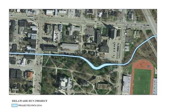
2 Delaware Run Restoration Research and Analysis Continued: Friday May 2 nd 2014 Introduction: During the spring semester 2014 the Streams to Dreams team decided the importance of building on the research gathered from the previous semester. To keep continuity we wanted to see this project evolve in a way where each semester was able to provide their fingerprint. This would allow for the project to continuously move forward and gain momentum as additional classes grappled with adding their perspectives and information to the project. Fall 2013 fingerprint: Spring 2014 fingerprint: As we began to study the information from fall 2013 we also started to develop our own direction for where we wanted to help assist in this projects growth: Our Project goals: Get more information on the storm water credits. Get additional terminology to better help understand floodplain areas. Work on soil sample information in arc GIS, try to get a better feel for the flood plain area. Map out all the trees next to the Delaware Run. Start getting an idea of soil types in the area to predict flood plain. Gather as much information to project the new path of the Delaware Run. Provide as much information for future. Provide suggestions for future classes to keep continuity. Provide all data information for future classes to build upon. Additional research and analysis: Soil Terminology:
3 Storm Water Credits: OHIO: DELAWARE: nual.pdf Procedure: The procedure for the Delaware Run restoration that we are going to do this semester was a small but large part of research and data collection that needs to be done. This research is important to have done before we can even start working on the Run. We are going to map out in AcrGIS the points of all of the trees in the affected area along with some soil samples. What we are going to do for the tree data: Have a printout map of the area of research from the ArcGIS Orthophoto from the Delaware data Mark on the map the points of the trees Number the trees and collect data The data we collected from the trees was o o o o o Circumference Estimated Height Native or invasive Type of tree If it s a part of the OWU Arboretum If we are not sure on some of the information like the type of tree and if it was native or invasive we will label it unknown in the attributes table. What we are going to do for the soil sample data: We located on the soil maps from the Delaware data in ArcGIS two different soil types. We are going to try and see if we can tell the difference between the two soils types. Also we are going to see if there was construction fill put in to make the Run straight.


4 We are also going to see how far down we must dig until we hit stone or water in the sediment. What we are going to do with the collected data With this data we are going to project a path for the run, closer to its original meander. We are going to avoid arboretum trees. With this data and the projected path we think that we are laying a great foundation for the research and projection that needs to be done before this project can break ground. Results: After collecting field data for all of the trees in the flood plain of the Delaware run, we placed the information into ArcGIS. The data was sorted by 3 different maps; A, B and C. The only trees we could identify were in the OWU arboretum but as a short term goal for future participates we would like to identify all trees within the area. After collecting soil samples in five different locations, we were unable to tell if there was fill from the previous football field. We were able to clarify that this area is indeed a wetland and that our projected path will be inside the floodplain. Our projection of the flood plain involves us moving three small arboretum trees to a different location on the floodplain. Because they are small they will transfer more easily then the larger arboretum tree on the cut bank of the projected path.


5 By mapping out all of the trees within the floodplain we were able to project a path that would involve the least destruction of natural habitat. The meander we added to the Delaware run emulates its original path in order to start the processes of de-channelization. Maps:
6
 4.")
 8.")
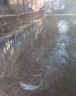
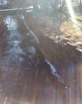
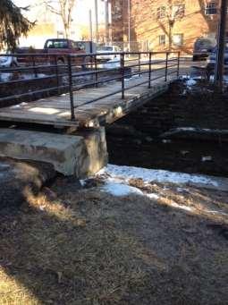
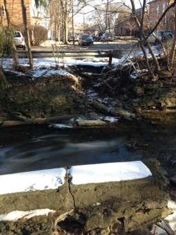
7 Goals for Buildings and Grounds: (Excerpt from Peter Schantz ) Delaware run maintenance issues to be considered during a renovation project March 10, Fix wall on south bank at Sandusky Street bridge 2. Fix wash out east of bridge support 3. Re-engineer bridge at Edgar (span will likely increase and support and landing reworked) 4. Clean out accumulated plant material and trash 5. Repair or remove leaning south wall of run between 2 pedestrian bridges 6. Identify if data or other infrastructure still runs through concrete raceway between bridges 7. Re-engineer bridge east of Edgar (span will likely increase and support and landing reworked) 8. Repair cave in of North side wall east of eastern most pedestrian bridge 9. Install maintainable banks where retaining walls are to be removed
8

")
9 Short Term Goals: River Clean Up (Still Not Complete, See 2013 fingerprint) Ecological Studies (Still Not Complete, See 2013 fingerprint)


10 Buildings and Grounds wall restoration and removal:

11 Tree Identification: 2014 we mapped the trees next to the run, still need to determine tree types. Nancy Murray and David Johnson sent us information and will be able to help further identify these tree species. Contacts: Material Sent: Soil Samples: We were able to begin the process of soil samples but our testing was mostly inconclusive. We were trying to determine if there was fill put down to level this area for the OWU practice field. We suggest further analysis to determine whether this was in fact leveled, by doing more soil samples. Long Term Goals: Time and resources allowing, the Delaware Run on Campus could become not only a healthy stream environment, but also an outdoor area for classes from the sciences to the philosophy to promote projects from species study to sound ecology. Eventually, provided it is the best option, the Run could even be dechannelized and restored to its previous state. (Fall 2013 team Pg. 5) Continue the work on the area with hopes on actually moving the Run. We would like to see the run moved in such a way that it provides a more approachable nature scape and wet land research area. Due to the projection of the run we would like to see a nice over look platform for student to be able to relax and study next to this wonderful water feature on OWU campus. This general idea is to provide both a platform and a retaining wall to prevent the run from meandering too much towards OWU campus. Idea:


12 Conclusion: This project started out with a lot of moving parts, and could have easily become overwhelming. However, after a little bit of brainstorming and using the direction set from the previous group, we were able to figure out how we would include our fingerprint for the spring 2014 semester. During the project our group learned the many different parts of ArcGIS, including gathering and organizing the data so that it could be mapped. Our group contributed this semester to the Delaware Run project by mapping out the trees. Then we were able to project a new path where the run could be moved with the least amount of damage to the arboretum trees. We finished up by taking some preliminary soil samples and gathering all the data we received. This will hopefully give the next group a clear idea to what the next actions will be to further this project. This project has been a very good learning experience for our group because it helped us realize to take the project in smaller parts rather than taking on multiple parts at once. It was very enjoyable to work on this project in a group and push ourselves to exceed our expectation and achieve something we all feel very proud of. Streams to Dreams Team Spring 2014 OWU: L-R: Zachary Siefker, Ali Smith, Max Kerns, and Wilson Taylor Contact List: Zachary Siefker zesiefke@owu.edu Max Kerns mdkerns@owu.edu Ali Smith arsmith@owu.edu Wilson Taylor awtaylor@owu.edu
Urban runoff in my neighborhood (Capitol Hill) is heavy with trash and other debris.
 is heavy with trash and other debris.") South Platte River Meeting Comments & s #1 I am a huge fan of river areas and would love the Platte and surrounding waterways to improve to allow habitat for wildlife and recreation opportunities for citizens.
South Platte River Meeting Comments & s #1 I am a huge fan of river areas and would love the Platte and surrounding waterways to improve to allow habitat for wildlife and recreation opportunities for citizens.
SECTION 5: REACH RECOMMENDATIONS/MAPS
 SECTION 5: REACH RECOMMENDATIONS/MAPS This section describes areas of concern and provides specific recommendations for each project reach. Locations of stormwater drains were from GIS coverage supplied
MCCOYS CREEK RESTORATION 30% DESIGN
 MCCOYS CREEK RESTORATION 30% DESIGN THE MCCOYS CREEK RESTORATION PLAN The restoration plan aims to reduce flooding, restore ecosystem health, expand recreational opportunities along the creek, and connect
Going Green Action Plan
 Going Green Action Plan Lauren Rah Rebecca Stolz Alexandra Turner Dec. 13, 2013 Wildlife conservation has become an important environmental issue due to invasion of non-native animals and plants and to
Why the workshop, why the cases?
 Green Infrastructure in Central and Eastern Europe Cases from the Czech Republic, Poland and Romania Kristijan Civic, ECNC and Agnes Zolyomi, Zolyomi, CEEweb Workshop on redesigning the landscape, connecting
LOUISIANA STATE UNIVERSITY COMPREHENSIVE & STRATEGIC CAMPUS MASTER PLAN. APPENDIX G - Stormwater Study Findings & Stormwater Solutions
 LOUISIANA STATE UNIVERSITY COMPREHENSIVE & STRATEGIC CAMPUS MASTER PLAN APPENDIX G - Stormwater Study Findings & Stormwater Solutions LSU: MP Narrative July 2017 3.5 Open Space Existing Conditions The
Preliminary Sketch Plan for Fort Hunter Park
 Preliminary Sketch Plan for Fort Hunter Park Public Presentation November 19, 2009 Dauphin County Parks and Recreation 100 Fort Hunter Road Harrisburg, PA 17110 (717) 599-5188 www.dauphinc.org THOMAS COMITTA
The Napa River Flood Protection Project
 The Napa River Flood Protection Project Creating Flood Protection and Restoring Geomorphic and Biological Processes Jeremy Sarrow, Napa County Flood Control & Water Conservation District June 2, 2014.
2008 Annual report of the UT Presidents Commission on the River
 The University of Toledo The University of Toledo Digital Repository President's Commission on the River Office of the President 2008 Annual report of the UT Presidents Commission on the River Patrick
The Benefits and Challenges Associated with Green Infrastructure Practices
 The Benefits and Challenges Associated with Green Infrastructure Practices Thomas M. Evans ASLA, LEED AP Regional Green Infrastructure Design Services Director OWEA Technical Conference, June 20, 2013
Lower Don River West Remedial Flood Protection Project TABLE OF CONTENTS. Page. Executive Summary
 TABLE OF CONTENTS Page Executive Summary 1.0 INTRODUCTION...1-1 1.1 Purpose of the Undertaking...1-1 1.2 Study Area Description...1-1 1.3 Description of the Undertaking...1-1 1.4 Rationale for the Undertaking...1-2
Lake and Stream Restoration Project
 Pre-project Fact Sheet May 2012 Toledo Botanical Garden (TBG) is a 60 acre public garden visited by more than 120,000 people annually. It is located in Toledo, Ohio in the Ottawa River watershed within
Gather information from online resources covering the following topics:
 Assignment #1: Regional Analysis Project Site Location: Greater Boston Area What comprises a region? The many elements within a region comprise the region as a whole. Natural as well as manmade environmental
Monica Smith, PE President Robinson Engineering Company
 Monica Smith, PE President Robinson Engineering Company Owner Robinson Engineering Masters Degree in Water Resource Management for Colorado State University The Dry Run Creek project got me interested
Los Angeles River-Arroyo Seco Confluence Restoration Vision Plan. Professor Meredith McKenzie, JD Urban & Regional Planning Dept Cal Poly Pomona
 Los Angeles River-Arroyo Seco Confluence Restoration Vision Plan Professor Meredith McKenzie, JD Urban & Regional Planning Dept Cal Poly Pomona The Los Angeles River Watershed Arroyo Seco Watershed Map
Stormwater and Ecological Management Opportunities May 2008
 Stormwater and Ecological Management Opportunities May 2008 University of Delaware Newark Campus Stormwater and Ecological Observations Unique geologic setting on fall line (divide between Piedmont and
Potomac Headwaters Leaders of Watersheds Spring 2019 Application
 Potomac Headwaters Leaders of Watersheds Spring 2019 Application Educating future generations of environmental stewards through classroom education and on the ground conservation practices at schools.
Outfall Reconnaissance Inventory & Stream Assessment
 CITY OF TUMWATER Outfall Reconnaissance Inventory & Stream Assessment City of Tumwater 555 Israel Road SW Tumwater, WA 98501 ACKNOWLEDGEMENTS City of Tumwater Outfall Reconnaissance Inventory and Stream
Summer Public Education and Outreach Campaign Toolkit
 Summer Public Education and Outreach Campaign Toolkit ABOUT THIS TOOLKIT The communications tools and messages included in this toolkit were developed by Bluestem Communications for the Lower DuPage River
WEFTEC.06. ** City of Caldwell, Idaho
 COST-BENEFIT ANALYSIS OF URBAN STORMWATER RETROFITS AND STREAM DAYLIGHTING USING LOW IMPACT DEVELOPMENT TECHNOLOGIES Sherrill Doran*, Dennis Cannon** * CH2M HILL, 322 East Front Street, Suite 200 Boise,
Stormwater and Your Rain Garden
 Stormwater and Your Rain Garden When rain falls on natural areas, such as a forest or meadow, it is slowed down, filtered by soil and plants, and allowed to soak back into the ground. When rain falls on
Water Works: Downtown Minneapolis Riverfront Destination
 Water Works: Downtown Minneapolis Riverfront Destination Previous conceptual design process for Water Works began in 2012 along with the Central Mississippi Riverfront Regional Park Master Plan Update
Stream Corridor Management Plan
 Stream Corridor Management Plan A unified and comprehensive approach to protecting, restoring and managing the Upper Delaware River Graydon Dutcher Delaware County Soil and Water Conservation District
Public Meeting for the Redevelopment of. July 17,2018 7pm to 9pm Rolling Knolls Elementary School
 Public Meeting for the Redevelopment of July 17,2018 7pm to 9pm Rolling Knolls Elementary School Meeting Agenda Welcome/ Community Meeting Key Project Information History - Damian Cosby, DRP- Chief of
Follow the Drop. Activity Overview Students observe and collect information about water runoff on their school property.
 Follow the Drop Activity Overview Students observe and collect information about water runoff on their school property. Objective Students will: 1. Practice observation and investigative skills 2. Survey
Rain Gardens. A Welcome Addition to Your Landscape
 Rain Gardens A Welcome Addition to Your Landscape Where Does The Rainwater Go? Naturally, forests provide a way for rainwater to percolate into the soil, filtering pollutants while trees are allowed to
An Ambitious Plan: Transforming the blighted South Platte River and surrounding environment into Denver s greatest natural resource.
 CONNECTING THE PEOPLE TO THEIR RIVER SOUTH PLATTE RIVER VISION IMPLEMENTATION PROGRAM: GRANT-FRONTIER PARK TO OVERLAND POND PARK REACH The South Platte River Vision Implementation Program (River Vision)
Julia Noordyk Water Quality Outreach Specialist Wisconsin Sea Building Resilient Communities One Code at a Time
 Julia Noordyk Water Quality Outreach Specialist Wisconsin Sea Grant @NoordCoast Credits: Juli Beth Hinds Birchline Planning, LLC Kate Morgan Milwaukee Metropolitan Sewerage District Building Resilient
ROSS Appendix F Land Conversion. Ecosystem Services Value Lost from Land Conversion in the Central Puget Sound Region ( )
") Ecosystem Services Value Lost from Land Conversion in the Central Puget Sound Region (1992-2011) 1 Purpose The purpose of this study is to estimate, in dollars, the value of annual ecosystem services in
Ecosystem Services Value Lost from Land Conversion in the Central Puget Sound Region (1992-2011) 1 Purpose The purpose of this study is to estimate, in dollars, the value of annual ecosystem services in
NORTH DISTRICT. Description
 VI plan and major recommendations district plans north disrict NORTH DISTRICT Description The North District comprises approximately 105 acres and is bounded by two important bio-habitats and corridors
Checklists. Project Name: Location: File Number: Date of Submittal: Reviewer: Date: Applicant: Contact Name: Phone Number:
 Applicant: Contact Name: Phone Number: Email: Project Name: Location: File Number: Date of Submittal: Reviewer: Date: Concept Plan Requirements: I. General Project Information 1. Address or parcel number
River Kleine Nete : Creating ecological flooding zones at recreation areas
 Stoffel Moeskops Lange Kievitstraat 111-113 bus 64 B-2018 ANTWERPEN T +32 3 205 81 25 s.moeskops@vmm.be River Kleine Nete : Creating ecological flooding zones at recreation areas \\\\\\\\\\\\\\\\\\\\\\\\\\\\\\\\\\\\\\\\\\\\\\\\\\\\\\\\\\\\\\\\\\\\\\\\\\\\\\\\\\\\\\\\\\\\\\\\\\\\\\\
2.4 FUTURE LAND USE ELEMENT Goals, Objectives and Policies
 GOAL 1: To create developmental patterns that direct future growth to appropriate areas on campus, in a manner that promotes the educational mission of the University, the protection of environmentally
Guiding Landowners in Stream Restoration. The Science, Practice & Art of Restoring Native Ecosystems 2015
 Guiding Landowners in Stream Restoration The Science, Practice & Art of Restoring Native Ecosystems 2015 January 24, 2015 Guiding Landowners in Stream Restoration January 24, 2015 Agenda 1Watershed Planning
water resource specialists
 Vaughn Collins, PE, CFM, Northwest Hydraulic Consultants Brad Livingston, Oregon Department of Transportation Melissa Reich, North Coast Land Conservancy Location Necanicum River 75 sq mi watershed Active
Using AutoCAD Civil 3D and ESRI ArcGIS to meet LEED-ND (Neighborhood Development) Requirements NDIA O Brien & Gere. All Rights Reserved.
 Requirements NDIA O Brien & Gere. All Rights Reserved.") Using AutoCAD Civil 3D and ESRI ArcGIS to meet LEED-ND (Neighborhood Development) Requirements NDIA 12457 1 Using AutoCAD Civil 3D and ESRI ArcGIS to meet LEED-ND (Neighborhood Development) Requirements
Using AutoCAD Civil 3D and ESRI ArcGIS to meet LEED-ND (Neighborhood Development) Requirements NDIA 12457 1 Using AutoCAD Civil 3D and ESRI ArcGIS to meet LEED-ND (Neighborhood Development) Requirements
Stream Restoration: Working with Nature?
 Stream Restoration: Working with Nature? Greg Jennings, PhD, PE jenningsenv@gmail.com Ecosystem Restoration activities that initiate or accelerate the recovery of ecosystem health, integrity, and sustainability
Stream Restoration: Working with Nature? Greg Jennings, PhD, PE
 Stream Restoration: Working with Nature? Greg Jennings, PhD, PE jenningsenv@gmail.com Ecosystem Restoration activities that initiate or accelerate the recovery of ecosystem health, integrity, and sustainability
POLE BRIDGE ROAD NEAR FIVE LOT FARM
 Drainage Improvements Village of Avon Pole Bridge Road near Five Lot Farm December 2014 POLE BRIDGE ROAD NEAR FIVE LOT FARM Pole Bridge Road is the eastern border of the Village south of NYS route 5 &
Lilburn, GA STORMWATER BMP AND STREAM RESTORATION IN A CITY PARK. July 2013 Jill Stachura
 Lilburn, GA STORMWATER BMP AND STREAM RESTORATION IN A CITY PARK July 2013 Jill Stachura Project Location Gwinnett County, GA: Population: 825,000 Area: 437 sq. miles 1,300 miles storm drainage system
CHAPTER 8 ISSUES, CONCERNS, CONSTRAINTS AND OPPORTUNITIES
 CHAPTER 8 ISSUES, CONCERNS, CONSTRAINTS AND OPPORTUNITIES Introduction This River Conservation Plan was developed during a time of tremendous activity and effort in planning the transformation of the Delaware
Holland Country Club Golf Course to Wetlands
 Holland Country Club Golf Course to Wetlands John Scholtz, Director Ottawa County Parks & Recreation Commission Amy A. Berry, Project Manager Niswander Environmental, LLC OTTAWA COUNTY PARKS: Focusing
Tracking spatiotemporal patterns of building vulnerabilities and evacuations during flood hazards
 Tracking spatiotemporal patterns of building vulnerabilities and evacuations during flood hazards Shane Hubbard Junchuan Fan Kathleen Stewart Emily White The University of Wisconsin Madison, SSEC/CIMSS
Required total credit : 43 All graduate students must register one of RES 501, RES 502 or RES 503, RES 504 or RES 505, RES 506 or RES 509, RES 510.
 İZMİR INSTITUTE OF TECHNOLOGY GRADUATE SCHOOL OF ENGINEERING AND SCIENCES DEPARTMENT OF ARCHITECTURAL RESTORATION CURRICULUM OF THE M.S. PROGRAM IN ARCHITECTURAL RESTORATION (NON-THESIS) Fall Semester
Is a Riparian Restoration Still Viable After 100-year Storm Events Alter the Original Design?
 Is a Riparian Restoration Still Viable After 100-year Storm Events Alter the Original Design? Sarah Spear Cooke, Ph.D. Seattle, Washington Presentation Outline Introduction The site pre-restoration Restoration
Figure 1. Proposed Strategic Habitat Conservation Areas for Florida
 Figure 1. Proposed Strategic Habitat Conservation Areas for Florida Critical Lands and Waters Identification Project (CLIP) Cooperative Effort Century Commission for Sustainable Florida Florida Natural
Stormwater Management Techniques WMPF LAND USE TRAINING INSTITUTE MARCH 14, 2018
 Stormwater Management Techniques WMPF LAND USE TRAINING INSTITUTE MARCH 14, 2018 Potential Impacts of New Development Urban development can significantly increase stormwater runoff Water quality considerations
Biodiversity Conservation
 Biodiversity Conservation and Site Plan Review Biodiversity conservation principles Threats to biodiversity Location of development Reviewing site plans Lunch Reviewing site plans (continued) LEED and
Restoring Water Ecosystems in NYC Parks
 Restoring Water Ecosystems in NYC Parks Hooked on our Waters Con October 19, 2013 - CUNY Graduate Center Marit Larson NYC Parks Landscape and ecosystem focus Watershed Streams Freshwater wetlands Tidal
PRE-DESIGN CONCEPT REPORT GRAND CANAL RESTORATION
 PRE-DESIGN CONCEPT REPORT GRAND CANAL RESTORATION Project Background November 19, 2007 Executive Summary The Grand Canal is an important tidal waterway in the Venice community of Los Angeles, California,
Jill Stachura STORMWATER BMP AND STREAM RESTORATION IN A CITY PARK. October 2013 Southeast Stormwater Association Annual Conference, Charlotte, NC
 Jill Stachura STORMWATER BMP AND STREAM RESTORATION IN A CITY PARK October 2013 Southeast Stormwater Association Annual Conference, Charlotte, NC Project Location Gwinnett County, GA: Population: 825,000
The 3 Common Landscape Challenges. & How to Transform them into Features
 The 3 Common Landscape Challenges & How to Transform them into Features Think That Your Landscape is Doomed Because of its Limited Size, Slope, or Drainage Issue? There are many common issues that homeowners
2,000 Sq. Ft. Traveling Exhibition EXHIBIT DESCRIPTION
 2,000 Sq. Ft. Traveling Exhibition EXHIBIT DESCRIPTION Against the tide of history, unlikely partners work side by side in the hope of undoing environmental and cultural damage and making a balanced and
Complete Neighbourhood Guidelines Review Tool
 Complete Neighbourhood Guidelines Review Tool Prepared By: City of Regina Planning Department October 2014 Page 1 of 14 Community Development Review Checklist for Secondary Plans and Concept Plans The
319 Grant: Baker Creek & Centenary Creek Restoration Initiative
 319 Grant: Baker Creek & Centenary Creek Restoration Initiative Objectives: Overview of Watershed Characteristics: Discussion of Project Tasks: Discussion of Watershed Management Plan: Presented by: Erich
LANDSCAPE ARCHITECTURAL DESIGN: PROCESS, PREDILECTIONS, AND PRIORITIES
 LANDSCAPE ARCHITECTURAL DESIGN: PROCESS, PREDILECTIONS, AND PRIORITIES ECOLOGICAL DESIGN IN THE SOUTHEAST APRIL 23, 2014 DR. JON CALABRIA, ASLA ASSISTANT PROFESSOR, COLLEGE OF ENVIRONMENT AND DESIGN, UNIVERSITY
Green Infrastructure Modeling in Cincinnati Ohio. Small Scale Green Infrastructure Design Using Computer Modeling
 Green Infrastructure Modeling in Cincinnati Ohio Small Scale Green Infrastructure Design Using Computer Modeling Presenters Jason Abbott is a Design Engineer with over 17 years of experience. Jason is
Mendota Heights 2040 Comprehensive Plan Draft Vers
 4 Parks and Trails The City of Mendota Heights boasts a variety of recreational and open space opportunities. Few cities can claim access to regional trails, riverside and lakeside parks, scenic bluffs
Lower Meramec Multi-Jurisdictional Floodplain Management Plan Public Involvement (Results of Early Public Engagement) 27 June 2018
 27 June 2018") Lower Meramec Multi-Jurisdictional Floodplain Management Plan Public Involvement (Results of Early Public Engagement) 27 June 2018 Public Involvement Summary: The planning process includes opportunities
Lower Meramec Multi-Jurisdictional Floodplain Management Plan Public Involvement (Results of Early Public Engagement) 27 June 2018 Public Involvement Summary: The planning process includes opportunities
Workshop Purpose Workshop Agenda Discussion Group Questions
 Library Garden Co-Discovery Workshop Group Discussion Notes September 30, 2015 Workshop Purpose Building on the Library Garden Values + Revitalization Study and project Design Brief, establish a common
Donaldson Run Tributary B Stream Restoration Project Update. February 23, 2011 Taylor Elementary School
 Donaldson Run Tributary B Stream Restoration Project Update February 23, 2011 Taylor Elementary School Big picture concepts Past land use and drainage decisions have severely impacted County streams Watershed
STREAM BANK STABILIZATION THORPS MORTIMER RECREATION AREA Grandfather Ranger District SITE LOCATION & DRAINAGE AREA
 STREAM BANK STABILIZATION THORPS CREEK @ MORTIMER RECREATION AREA SITE LOCATION & DRAINAGE AREA SITE LOCATION Drainage Area = 1.14 sq. miles STREAM BANK STABILIZATION THORPS CREEK @ MORTIMER RECREATION
Landscape Architecture (L A)
") Iowa State University 2013-2014 1 Landscape Architecture (L A) Courses primarily for undergraduates: L A 201. Studio: Landscape Interpretation and Representation. (1-15) Cr. 6. F. Prereq: Enrollment in
Iowa State University 2013-2014 1 Landscape Architecture (L A) Courses primarily for undergraduates: L A 201. Studio: Landscape Interpretation and Representation. (1-15) Cr. 6. F. Prereq: Enrollment in
FURTHER TO EXECUTIVE COMMITTEE MEETING #11/12 To be held on Friday, January 11, 2013
 FURTHER TO EXECUTIVE COMMITTEE MEETING #11/12 To be held on Friday, January 11, 2013 FURTHER TO: Pages EX10. APPLICATION FOR PERMITS UNDER ONTARIO REGULATION 166/06 Development, Interference with Wetlands
RAIN GARDENS. Task: PART 1 (60 minutes) Student Directions: Steps you will be following: Directions for beginning: Source Information:
 Student Directions: Steps you will be following: Directions for beginning: Source Information:") PART 1 (60 minutes) Student Directions: Your assignment: Steps you will be following: Your neighborhood council is researching the benefits of installing rain gardens in your community. You will read two
PART 1 (60 minutes) Student Directions: Your assignment: Steps you will be following: Your neighborhood council is researching the benefits of installing rain gardens in your community. You will read two
Urban Stormwater Retrofit Program Highlights
 Urban Stormwater Retrofit Program Highlights Delaware Estuary Environmental Summit 2007 Prepared and Presented by: Liz Feinberg Project Funding: William Penn Foundation PA Coastal Zone Management Program
Community LID Workgroup Issue Paper #6
 Community LID Workgroup Issue Paper #6 Topic: Hard and Impervious Surface Coverage Limits Objective: Minimize the amount of hard and impervious surfaces in developments to allow more stormwater to infiltrate
Cost Effective Low Impact Development
 Cost Effective Low Impact Development An Introductory Guide to Conserve Land, Restore Resources, Protect Water, and Save Money in Massachusetts Stefanie Covino Shaping the Future of Your Community Program
The following principles guide the development of goals and strategies to protect and promote these amenities:
 OPEN SPACE/PARKS/TRAILS/RECREATION GOALS/STRATEGIES Cherry Hills Village is a living environment that offers low density development, open areas, public scenic vistas, public trails and public parks. This
Post Construction BMPs
 Post Construction BMPs Why are Post Construction BMPs important? With increased development brings the increase of impervious cover Parking lots, rooftops, driveways Storm water runoff volume increases
Marion Street Green Infrastructure Project. Whittier Neighborhood Community Meeting April 18, 2018
 Marion Street Green Infrastructure Project Whittier Neighborhood Community Meeting April 18, 2018 Agenda Water quality and green infrastructure Overview: Marion Street stormwater project Green infrastructure
Welcome to our public exhibition
 About Our Scheme Welcome to our public exhibition This exhibition gives you the chance to view and comment upon our emerging proposals for a new residential development of 68 new homes on the site of the
Once Upon a Gravel Pit: Reconnecting Floodplain through Aggregate Extraction
 Once Upon a Gravel Pit: Reconnecting Floodplain through Aggregate Extraction 5 th International Conference on Natural Channel Systems September 26, 2016 1 The Story of Snyder s Flats Historical influences
Learning from Nature: Reducing Urban Stormwater Impacts
 This article was published in the Spring, 2005 Issue of LakeLine magazine It is posted on the Urban Drainage and Flood Control District s web site with the authors and the publishers permission to the
Each course is worth 1 American Institute of Architects CEU/HSW.
 Each course is worth 1 American Institute of Architects CEU/HSW. Introduction to Mobile Mapping Attendees will learn the basics of mobile mapping including history, trends, components, and uses. This course
NEIGHBORHOOD 8: NORTHEAST AREA
 NEIGHBORHOOD 8: NORTHEAST AREA Carillon Tower Aerial View of Northeast Area Northeast Area Map 288 neighborhoods NEIGHBORHOOD 8: NORTHEAST AREA Campus View Apartments Student Recreational Sports Center
Poisoned Park? How Exide s Lead Contamination Risks Frisco s Grand Park
 Frisco City Hall has big plans to transform Stewart Creek into a Grand Park with lots of water features for kids to play in. Poisoned Park? How Exide s Lead Contamination Risks Frisco s Grand Park But
Experiences and Adoption of Low Impact Development in City of Fort Worth
 Experiences and Adoption of Low Impact Development in City of Fort Worth Ranjan S. Muttiah Stormwater Management City of Fort Worth ranjan.muttiah@fortworthtexas.gov Factoid The most common man made material
INTRODUCING THE BALTIMORE CITY GREEN NETWORK VISION PLAN
 INTRODUCING THE BALTIMORE CITY GREEN NETWORK VISION PLAN GOALS OF THE GREEN NETWORK PLAN Protect and enhance the unique ecological resources of our city Support economic growth and sustainable redevelopment
Working with nature to manage your stream
 Working with nature to manage your stream Issued by Auckland Council March 2013 If you have any questions about this information sheet please contact Auckland Council on 09 301 0101 A stream in a property
Information for File #MVP DAS
 Information for File #MVP201702209DAS Applicant: HyVee, Inc. Corps Contact: David Studenski Address: 1114 South Oak Street, La Crescent, Minnesota 559471560 EMail: david.a.studenski@usace.army.mil Phone:
Wetland Restoration In Altered Landscapes
 Wetland Restoration In Altered Landscapes Mike McClure, Wetland Service Biologist, MO Dept. of Conservation Wetland Restoration In Altered Landscapes Do s, Don ts and Things To Think About Assessing the
Storm Water Managament at the University of Michigan
 Storm Water Managament at the University of Michigan Standard Operating Procedure Date: 06/23/17 Revision #: 03 The green roof installed on top of the Mott Children s & Von Voigtlander Women s Hospital.
Water Cycle ARC-452 DESIGN VI: INTEGRATION A5 ENVIRONMENTAL SYSTEM BURGENER SIMON YANGCHUAN SUN
 Water Cycle ARC-452 DESIGN VI: INTEGRATION A5 ENVIRONMENTAL SYSTEM BURGENER SIMON YANGCHUAN SUN Table of Content Overview Protect and Conserve Water Sustainable Drainage System Green Roof Green Wall Rain
SOUTH FOX MEADOW STORMWATER IMPROVEMENT PROJECT
 VILLAGE OF SCARSDALE WESTCHESTER COUNTY, NEW YORK COMPREHENSIVE STORM WATER MANAGEMENT SOUTH FOX MEADOW STORMWATER IMPROVEMENT PROJECT In association with WESTCHESTER COUNTY FLOOD MITIGATION PROGRAM Rob
Jessica Cheval. Mindy Cooper EMPACTS. Watershed Protection. Introduction
 Jessica Cheval Mindy Cooper EMPACTS Watershed Protection Introduction Conserving and protecting water fronts is an important aspect to maintaining water quality all over the world. Not only do the conditions
Module 1 ~ Silent Invaders (MS/HS) Emersed Plants Reading Activity
 Emersed Plants Reading Activity") Name: Class Period: Date: Directions: Read the passage and use the information you ve learned to answer the questions below using complete sentences. Emersed plants are rooted in shallow water with much
Name: Class Period: Date: Directions: Read the passage and use the information you ve learned to answer the questions below using complete sentences. Emersed plants are rooted in shallow water with much
MPDP VEGETATION ADVISORY WORKGROUP WORKSHOP #1
 DATE: TO: LOCATION: MPDP Vegetation Advisory Workgroup SWA Group Office, 1245 West 18 th Street Meeting Purpose: Workgroup Orientation Introduce Participants to the Project Goals Develop a Statement of
Stormwater Management at The University of New Orleans
 University of New Orleans ScholarWorks@UNO DRU Workshop 2013 Presentations Disaster Resistant University Workshop: Linking Mitigation and Resilience Conferences and Workshops 3-1-2013 Stormwater Management
National Wildlife University Reston, Virginia Habitat Restoration George Mason University Grounds Shop Fairfax, Virginia 22030
 National Wildlife University Reston, Virginia Habitat Restoration George Mason University Grounds Shop Fairfax, Virginia 22030 Using Rain Gardens as a Storm Water Runoff Bioretention Technique in Established
Cosmo s World Biodiversity Overview
 Cosmo s World Biodiversity Overview Overview: The purpose of this program is to introduce fourth grade students to the importance of biodiversity. Vocabulary: Biodiversity: The variety of life on earth
8KITCHEN OUTDOOR PLANNING GUIDE OUTDOOR KITCHEN THINGS TO KNOW BEFORE INSTALLING AN
 OUTDOOR KITCHEN PLANNING GUIDE THINGS TO KNOW BEFORE INSTALLING AN OUTDOOR 8KITCHEN 1 TABLE OF CONTENTS 03 INTRODUCTION 04 05 06 07 08 09 10 10 11 YOU LL REGRET NOT GETTING A PROFESSIONAL DESIGN YOUR KITCHEN
FURNEAUX CREEK 5 CHANNEL
 FURNEAUX CREEK 5 CHANNEL AND TRAIL IMPROVEMENTS TEXAS CHAPTER AMERICAN PUBLIC WORKS ASSOCIATION PROJECT OF THE YEAR CATEGORY: ENVIRONMENT PROJECT OF $2 MILLION BUT LESS THAN $5 MILLION ENGINEERING DEPARTMENT,
Technical Memorandum 5
 Technical Memorandum 5 Environmental Resources August 2015 PREPARED BY AECOM Table of Contents Introduction... 3 Natural Features... 6 Watersheds... 6 Rivers, Lakes, Creeks... 6 Wetlands... 8 Floodplains...
Mississauga Waterfront. Parks Strategy - Draft
 Potential configuration for river s edge seating. Boating on Credit River: A regatta Boating on Credit River: Active enjoyment 5.2 Port Credit Memorial Park West Priority Park 5.2.1 Site Opportunities
Project Description WOO/LUC-SR /0.00. Waterville Bridge Replacement
 Ohio Department of Transportation District 2 317 East Poe Rd. Bowling Green, Ohio 43402 (419) 353-8131 John R. Kasich, Governor Jerry Wray, Director Todd Audet, P.E., District Deputy Director Project Description
River Restoration Practices:
 River Restoration Practices: Comparison of British Columbia and Central European Practices by David Matsubara and Dave Murray Add Map of North America VANCOUVER, Wa. Add Map of Vancouver OUTLINE Introduction
TH E U N IVE RSIT Y O F FLO R I DA LANDSCAPE MASTER PLAN REPORT
 TH E U N IVE RSIT Y O F FLO R I DA LANDSCAPE MASTER PLAN REPORT O C T O B E R 2 018 THE UNIVERSITY OF FLORIDA LANDSCAPE MASTER PLAN REPORT OCTOBER 2018 prepared by: CRJA-IBI Group GAI Community Solutions
Hollickwood Primary School, London
 Hollickwood Primary School, London SuDS used Bioretention bog garden Swales Detention areas Retention areas Benefits 1. Location Improvement of water quality. Reduction in local and wider flood risk. SuDS
Adopting the Manual of Best Management Practices for Stormwater Quality. Facts for Communities
 Adopting the Manual of Best Management Practices for Stormwater Quality Facts for Communities Adopting the Manual of Best Management Practices for Stormwater Quality September 2006 prepared for the Mid-America