Layered Infrastructure Systems. Baron Haussmann; les Grandes Boulevards, Paris
|
|
|
- Merry Willis
- 6 years ago
- Views:
Transcription

1

2 Paris

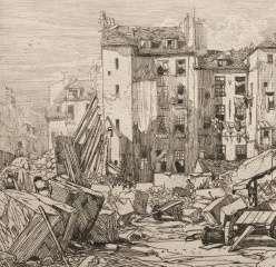

3 Layered Infrastructure Systems Baron Haussmann; les Grandes Boulevards, Paris


4 Layered Infrastructure Systems Baron Haussmann; demolition for construction of the Avenue de l Opera, Paris

5 Layered Infrastructure Systems Baron Haussmann; Boulevard Richard Lenoir, Paris

6 Layered Infrastructure Systems Avenue de l Opera: Morning Sunshine, Camille Pissaro, 1898


7 Developing new solutions to the problems created by a sprawl-dominated landscape will require a new thinking, and ultimately, a new kind of city. The BeltLine will change the way we think about Atlanta.

8 FESIBILITY PLANS REDEVELOPMENT PLAN SUB AREA PLANS OVERLAY ZONING TRANSIT PLANS PARK DESIGNS CORRIDOR DESIGN

9 Atlanta BeltLine Corridor Design
10 Atlanta BeltLine Corridor Design Team Atlanta BeltLine, Inc. Project Administrator Perkins+Will Design/Project Lead Amec, Inc. Lead Engineer and Surveyor James Corner Field Operations Conceptual Design Partner HDR Transit Engineer Stantec Consulting Roadway Engineer + Surveyor B&E Jackson Associates Engineer + Surveyor Agility Surveying Company Surveyor Kimley-Horn Associates Civil Engineer + PDP Pond / Ecos Landscape Architect + PDP Leni Schwendinger Light Projects Lighting Designer Buro Happold Sustainability Engineer Biohabitats Ecologist Danielle Roney LLC Public Art Consultant Morrison Design LLC Cultural Historian BCN Consulting Public Realm O+M Consultant HR&A Economics + Operations Strategist Lord Aeck Sargent Architecture Preservation Architect Costing Services Group Cost Estimator Panache Communications Community Engagement Consultant

11 ABCD Analysis


12 ABCD Design Drivers


13 ABCD Design Framework


14 ABCD Preliminary Design

15 ABCD Future Design Work
16 Atlanta BeltLine Corridor Design
17 Analysis Design Drivers Design Framework Preliminary Design Future Design Atlanta BeltLine Corridor Design Analysis

18 Mapping

19 Research

20 Field Work

21 Drawing

22 Analysis
23 Context Conditions Railroads Typical Conditions Analysis Context Conditions


24 Native Context

25 Railroad Context

26 Historical Context


27 Social Context


28 Political Context


29 Development Context


30 (Un)Natural Context


31 Ownership/Use Context

32 Physical Context
33 Context Conditions Railroad Conditions Typical Conditions Analysis Railroad Conditions


34 Four Belt Lines + Four Connectors


35 Four Connectors
36 Context Conditions Railroad Conditions Typical Conditions Analysis Typical Conditions

37 Track Position

38 Edges + Adjacencies

39 Street Connections

40 Natural Systems + Character

41 Alignment, Structures + Landform

42 Track Tectonics
43 Transit Trail Public Space Analysis Program

44 Transit

45 Trail

46 Public Space
47 ANALYSIS DESIGN Conditions Program Design Drivers Design Framework
48 Analysis Design Drivers Design Framework Preliminary Design Future Design Atlanta BeltLine Corridor Design Design Drivers


49 Design Drivers CHARACTER MULTI-RE-USE THRESHOLD PERFORMANCE PHASED BUILDOUT

50 Design Drivers CHARACTER Interpret and evoke its origin as a series o railroad corridors; Cultivate its sense of adventure, discovery and informality; Respect its unique landscape and historical features.

51 Design Drivers MULTI-RE-USE Transform it for a new set of infrastructure and a signature public meeting ground; Promote both mobility and destination; Design for changing interpretation of spaces and elements over time.

52 Design Drivers THRESHOLD Design a coherent public space, unchallenged by private adjacencies; Convert its back-door condition to be more fully accessible; Reconcile its goal of clarity with confusing adjacencies and existing conditions.

53 Design Drivers PERFORMANCE Support existing habitat and the generation of biodiversity; Optimize its performance through a sustainable approach to energy, water, light and materials; Where possible, contribute to broader sustainability goals and opportunities beyond its right-of-way.

54 Design Drivers PHASED BUILDOUT Design for incremental buildout of segments and features; Define ecologically strategic investments; Ensure that its amenities are equitably distributed and that it will meet future demands.
55 Analysis Design Drivers Design Framework Preliminary Design Future Design Atlanta BeltLine Corridor Design Design Framework

56 22 MILES OF VARIETY 22 MILES OF CONTINUITY
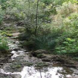
57 Landscape Lighting Public Art Design Framework 22 Miles of Variety

58 Variety Existing

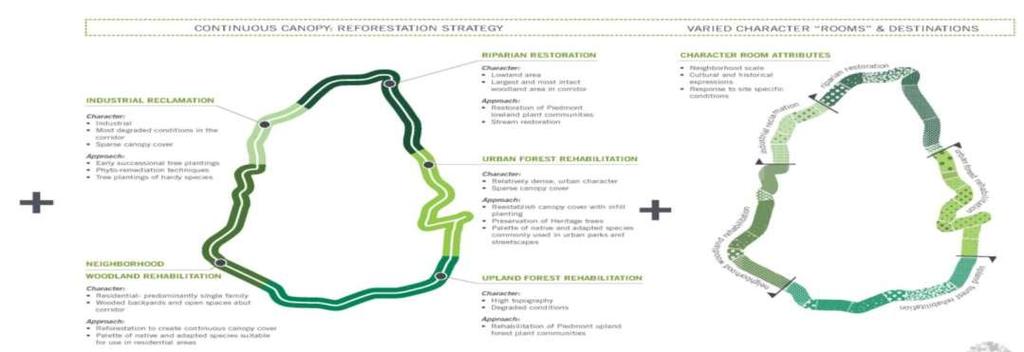
59 Variety Existing

60 Variety Proposed

61 Variety Character Rooms The Narrows Copenhill Sweep Angier Overlook North de Leon Magnolia Straightaway Kanuga Square

62 Variety BeltLine Spaces

63 Variety - Landscape

64 Canopy

65 Canopy - Features

66 Canopy Reforestation Strategies


67 Canopy Character Rooms


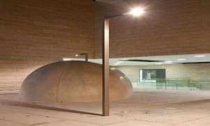
68 Floor

69 Landform

70 Landform

71 Landform

72 Landform

73 Landform


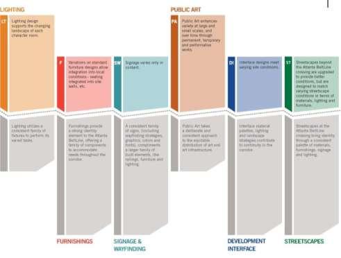
74 Variety Lighting


75 Variety Public Art

76 Variety Public Art

77 Variety Character Rooms

78 Variety The Narrows

79 Variety Copenhill Sweep

80 Variety North de Leon
81 Hardscape Transit Stations Bridges + Tunnels Furnishings Signage + Wayfinding Development Interface Streetscapes Design Framework 22 Miles of Continuity

82 Continuity Existing

83 Continuity Proposed


84 Hardscape

85 Hardscape

86 Bridges


87 Walls

88 Transit Stations


89 Transit Stations Concept Studies
90 Signage + Wayfinding Directional Informational Identification Regulatory
91 Signage + Wayfinding


92 Signage + Wayfinding

93 Development Interface Development Intensity

94 Development Interface Setback + Separation

95 Development Interface Topographic Adaptations

96 Streetscapes At-Grade Crossings

97 Streetscapes Above-Grade Crossings

98 Streetscapes Below-Grade Crossings

99 Design Framework
100 Analysis Design Drivers Design Framework Preliminary Design Future Design Atlanta BeltLine Corridor Design Preliminary Design

101 Preliminary Design

102 Preliminary Design
103 Analysis Design Drivers Design Framework Preliminary Design Future Design Atlanta BeltLine Corridor Design Future Design
104 Future Design Work

105 Eastside Trail Under Construction

106 Eastside Trail Under Construction Eastside Trail Construction (2011)

107 Eastside Trail Under Construction Eastside Trail Construction (2012)

108 Eastside Trail Under Construction Eastside Trail Construction (2012)

109 Eastside Trail Under Construction Eastside Trail Construction (2012)

110 Eastside Trail Under Construction Eastside Trail Construction (2012)
111 Watch an Expanded Version of this Presentation on YouTube Public Square Atlanta Webinar: Atlanta BeltLine Corridor Design

112 Thanks! Ryan Gravel, AICP Perkins+Will
WHERE WE WANT TO LIVE
 WHERE WE WANT TO LIVE @ryangravel ryan@sixpitch.com www.ryangravel.com RYAN GRAVEL ST MARTINS PRESS NEW YORK MARCH 15, 2016 Alexandria, Louisiana Geraldine Keller Gravel with daughter Gerry, 1940s (Gravel
Maplewood Avenue Downtown Complete Street Project
 Maplewood Avenue Downtown Complete Street Project Second Public Meeting January 24, 2018 Welcome and Introduction of Project Team City Planning and Public Works Staff City of Portsmouth Juliet Walker Planning
Rio/29 Small Area Plan. Design Plan & Implementation Framework Open House - January 25, 2018
 Rio/29 Small Area Plan Design Plan & Implementation Framework Open House - January 25, 2018 MEETING PURPOSE PRESENTATION 1. Orient to the updated design plans 2. Introduce implementing options 3. Explain
5. Father Hennepin Blufs Park and Hennepin Island Father Hennepin Bluffs Park Supporting Initiatives (see Figure 36): 7-22
: 7-22") 5. Father Hennepin Blufs Park and Hennepin Island As described in existing conditions portion of Chapter 2, Father Hennepin Blufs Park lies on the upland portion of the park and Hennepin Island spans the
5. Father Hennepin Blufs Park and Hennepin Island As described in existing conditions portion of Chapter 2, Father Hennepin Blufs Park lies on the upland portion of the park and Hennepin Island spans the
CHAPTER 5: GUIDING PRINCIPLES
 CHAPTER 5: GUIDING PRINCIPLES The following 10 principles were developed based on public consultation, planning policy and the background analysis conducted during Phase 1. The Guiding Principles significantly
2011 ASLA Design Awards
 2011 ASLA Design Awards Interstate 70 Mountain Corridor Aesthetic Guidance Honor Award Design Workshop, Aspen / THK Associates, Inc. / CH2MHill Planning and Urban Design Project Title: Interstate70 Mountain
Community Design Guidelines. Port Wallace DRAFT
 Community Design Guidelines Port Wallace DRAFT Energy 1 2 3 Nature Movement Connections Built Form DRAFT Layout Energy 1 Nature Community Design Guidelines GREAT COMMUNITIES PROTECT, CELEBRATE, AND CONSERVE
Atlanta BeltLine Subarea 3 Master Plan Update
 Atlanta BeltLine Subarea 3 Master Plan Update April 14, 2018 Workshop Meeting 1 22 miles, connecting 45 neighborhoods 22 MILES of transit 46 MILES of streetscapes and complete streets 33 MILES of urban
Kenilworth Station Art and Landscape Committee (KSALC) June 25, 2015
 June 25, 2015") Kenilworth Station Art and Landscape Committee (KSALC) June 25, 2015 1 Today s Topics Welcome and Introductions Appoint Committee Co-Chairs Summary of Community Workshop #1 Kenilworth Channel Bridge Design
Kenilworth Station Art and Landscape Committee (KSALC) June 25, 2015 1 Today s Topics Welcome and Introductions Appoint Committee Co-Chairs Summary of Community Workshop #1 Kenilworth Channel Bridge Design
UNIVERSITY AVENUE CORRIDOR REDESIGN JULY 10, 2017 KICK-OFF MEETING
 UNIVERSITY AVENUE CORRIDOR REDESIGN JULY 10, 2017 KICK-OFF MEETING COLLABORATIVE COMMUNITY-BASED DESIGN IS THE FOUNDATION TO A SUCCESSFUL PROJECT AGENDA FOR TONIGHT 1 INTRODUCTIONS 2 PROJECT LIMITS & OVERVIEW
BeltLine Corridor Environmental Study
 BeltLine Corridor Environmental Study Joint TAC and SAC Meeting December 8, 2008 What We Will Discuss Today Outreach and Agency Coordination Scoping Results Existing Conditions Historical and Archeological
10.0 Open Space and Public Realm
 10.0 Open Space and Public Realm 10.0 Open Space and Public Realm The Public Open Space System is comprised of: outdoor spaces available for public use that are either publicly owned (e.g., parks and
Table of Contents. Elm Avenue Improvement Plan City of Waco, Texas. Introduction 1. Existing Context 1 Figure 1 2.
 Table of Contents Introduction 1 Existing Context 1 Figure 1 2 Plan Guidelines 3 Future Urban Form 4 The West-End 4 Main Street 6 The East-End 7 Figure 2 9 Public Improvement Recommendations 7 General
Transit Implementation Strategy Westside Study Group Meeting
 Westside Study Group Meeting February 27, 2012 The Portland Streetcar Passing Through a Park Near Portland State University Westside Study Group Meeting February 27, 2012 1. TIA Update 2. TIS Process To-Date
Complete Neighbourhood Guidelines Review Tool
 Complete Neighbourhood Guidelines Review Tool Prepared By: City of Regina Planning Department October 2014 Page 1 of 14 Community Development Review Checklist for Secondary Plans and Concept Plans The
SECTION E. Realizing the Plan
 SECTION E Realizing the Plan 60 DESIGN REGINA - OFFICIAL COMMUNITY PLAN SECTION E Realizing the Plan Design Regina has been an ambitious plan-making exercise, with a high level of community, stakeholder,
The Atlanta BeltLine. Quarterly Briefing March @atlantabeltline. Reynoldstown Senior Affordable Housing
 The Atlanta BeltLine Quarterly Briefing March 30, 2017 @atlantabeltline @atlantabeltline @atlantabeltline Reynoldstown Senior Affordable Housing Framework for a multi-use and transit corridor in the heart
WILBURTON COMMERCIAL AREA
 WILBURTON COMMERCIAL AREA BELLEVUE DOWNTOWN ASSOCIATION L A N D U S E A N D L I VA B I L I T Y C O M M I T T E E B R A D L E Y C A LV E R T, A I C P C O M M U N I T Y D E V E L O P M E N T P R O G R A
Ivywild On The Creek PRELIMINARY CREEK DISTRICT MASTER PLAN
 Ivywild On The Creek PRELIMINARY CREEK DISTRICT MASTER PLAN Introduction: Rejuvenating an extraordinary Creekside neighborhood THE CREEKSIDE DISTRICT The Ivywild On The Creek Neighborhood District Master
Scope of Services. River Oaks Boulevard (SH 183) Corridor Master Plan
 Corridor Master Plan") Scope of Services River Oaks Boulevard (SH 183) Corridor Master Plan PROJECT AREA The project area consists of the River Oaks Boulevard (SH 183) corridor bounded by SH 199 at the northern end and the Trinity
Scope of Services River Oaks Boulevard (SH 183) Corridor Master Plan PROJECT AREA The project area consists of the River Oaks Boulevard (SH 183) corridor bounded by SH 199 at the northern end and the Trinity
Niagara National Heritage Area
 Niagara National Heritage Area What is a National Heritage Area? It is a regional place where natural, cultural, historic and recreational resources combine to form a nationally distinctive landscape and
Atlanta BeltLine Corridor Environmental Study. Scoping Meeting August 2008
 Atlanta BeltLine Corridor Environmental Study Scoping Meeting August 2008 What Will We Be Discussing Today? Study Overview - How Did We Get Here? - What Is the Study About? - Who Is Involved? - Where Is
Description of Preferred Alternative
 Chapter 2 Description of Preferred Alternative 2.1 Introduction This chapter of the programmatic Sammamish Town Center Sub-area Plan Final EIS provides a more detailed description of the Preferred Alternative
Panama City Beach Community Redevelopment Agency Condo Con Property Owner Conference & Expo November 14, 2014
 Panama City Beach Community Redevelopment Agency Condo Con Property Owner Conference & Expo November 14, 2014 Front Beach Road CRA On November 30, 2000, the City created the Panama City Beach Community
Bloor Street East Potential Ravine Portal Overlook and Access Passage to the Rosedale Valley and Don River Valley Ravine, Toronto, Canada
 TRANSFORMATIVE IDEA 2. GREAT STREETS Bloor Street Christie Pits Park Bloor St Spadina Ave Bathurst St Shaw St 1 Recognize the significant public realm improvements along Bloor Street and extend and enhance
Kenilworth Landscape Design Community Workshop. June 13, 2015
 Kenilworth Landscape Design Community Workshop June 13, 2015 1 Meeting Agenda 8:30 9:00 am: Project presentation 9:00 11:00 am: Small group / table activities 11:00 11:30 am: Reporting and next steps 11:30
Por favor, levanten la mano si necesita traduccion en espanol Please raise your hand if you need Spanish translation
 FEDERAL BOULEVARD CORRIDOR WIDE STUDY PUBLIC MEETING #1 APRIL 27, 2016 Por favor, levanten la mano si necesita traduccion en espanol Please raise your hand if you need Spanish translation HDR DESIGN WORKSHOP
TOWN COUNCIL / PLANNING COMMISSION
 Workshop #3 TOWN COUNCIL / PLANNING COMMISSION January 20, 2011 Consultant Team In Attendance Tonight BMS Design Group Nevada City and San Francisco Michael Smiley, AICP, ASLA Partner-in-Charge Nancy L.
DRAFT ROOSEVELT ROAD. District Recommendations. Figure 5.23 The Roosevelt Road Corridor
 CHAPTER 5 Figure 5.23 The Road Corridor Road will develop as a mixed-use corridor, emphasizing regional retail, west of the river and mixed-use development east of the river. KEY RECOMMENDATIONS 1. High
Kenilworth Station Art and Landscape Committee (KSALC) July 16, 2015
 July 16, 2015") Kenilworth Station Art and Landscape Committee (KSALC) July 16, 2015 1 Today s Topics Welcome and Introductions Review Proposed Concepts in Development Upcoming Events/Next Steps Questions and Open Discussion
Kenilworth Station Art and Landscape Committee (KSALC) July 16, 2015 1 Today s Topics Welcome and Introductions Review Proposed Concepts in Development Upcoming Events/Next Steps Questions and Open Discussion
Atlanta BeltLine, Inc. Pathways to Urban Sustainability
 Atlanta BeltLine, Inc. Pathways to Urban Sustainability September 30, 2010 WHAT IS THE ATLANTA BELTLINE? Transit 22-mile loop Parks 1300 + new acres Trails 33 miles Jobs & Economic Development 20 areas,
Table L-1 Summary Action Strategy. Action Item Timing Status Responsible Agency
 CHAPTER 4: CIRCULATION ELEMENT ISSUE #1: MAJOR THOROUFARES AND TRANSPORTATION ROUTES A balanced transportation system for Fontana is provided that meets the mobility needs of current and future residents
38 Queen s University Campus Master Plan Part 1
 38 Queen s University Campus Master Plan Part 1 46 The Campus at the City Scale Chapter 4 The Campus at the City Scale 39 Queen s is an urban University centrally located in Kingston. Decisions made by
Key Concepts of the General Plan
 Key Concepts of the General Plan General Plan Purpose Vision for City s future Standards for City Services Land Use Plan General Plan Purpose San Jose is creating its Blueprint for the Future to become
Chapter 1.0 Introduction
 Chapter 1.0 Introduction 1.1 Background The North Metro commuter rail line is part of the RTD FasTracks regional transit system expansion program to build more than 100 miles of rail transit throughout
2.5 Roads. Loading and service areas adjacent to Highway 401 should be screened through architectural walls and/or landscape buffer planting.
 N HIGHWAY OFF RAMP 2.5 Roads A legible road network with a clear hierarchy will help create a connected community, both within and surrounding the Milton Heights. The following section outlines the proposed
CREATE A VIBRANT MIXED-USE COMMUNITY
 CREATE A VIBRANT MIXED-USE COMMUNITY Land Use Public Realm Plan Built Form Heritage Tell us what you think! Place a sticky note here or leave us a comment form LAND USE The land use framework of this Secondary
Evaluation Criteria. Detailed Evaluation Criteria
 Evaluation Criteria Detailed Evaluation Criteria Community Well-being A safe and socially inclusive service that improves access to key community destinations and provides transportation choices for Calgarians.
SH 199 Corridor Master Plan. Community Meeting No. 2 May 31, 2017
 Community Meeting No. 2 May 31, 2017 Transportation Projects On or Near SH 199 SH 199 from 0.3 miles south of FM 1886 to south end of Lake Worth bridge Construct freeway mainlanes and frontage roads 10-Year
Atlanta BeltLine. Subareas 9 & 10. Master Plan Updates. March 26, Washington Park Jamboree 1
 Atlanta BeltLine Subareas 9 & 10 Master Plan Updates March 26, 2018 Washington Park Jamboree 1 22 miles, connecting 45 neighborhoods 22 MILES of transit 46 MILES of streetscapes and complete streets 33
Potential Green Infrastructure Strategies May 6, 2015 Workshop
 Potential Green Infrastructure Strategies May 6, 2015 Workshop Background The City of Cortland is developing the Tioughnioga Urban Headwaters Green Infrastructure Action Plan with funding from the National
Tropicana Site Redevelopment Committee of the Whole September 8, Image: City of St. Petersburg
 Tropicana Site Redevelopment Committee of the Whole September 8, 2016 Image: City of St. Petersburg City of St. Petersburg Planning & Economic Development Department Leading the Process HKS Urban Design
Gold Line Bus Rapid Transit Transit Oriented Development (BRTOD) Helmo Station Area Plan
 Helmo Station Area Plan") Appendix F Gold Line Bus Rapid Transit Transit Oriented Development (BRTOD) Helmo Station Area Plan Introduction and Purpose of the Plan The Gold Line Bus Rapid Transit facility is an eleven-mile dedicated
Appendix F Gold Line Bus Rapid Transit Transit Oriented Development (BRTOD) Helmo Station Area Plan Introduction and Purpose of the Plan The Gold Line Bus Rapid Transit facility is an eleven-mile dedicated
VIRGINIA / LAKE HIGHLAND TRANSPORTATION AND LAND USE STUDY
 VIRGINIA / LAKE HIGHLAND TRANSPORTATION AND LAND USE STUDY COMMUNITY MEETING #2 - PRESENTATION OVERVIEW 1 INTRODUCTION 2 CONTEXT STUDIES 3 VISION FRAMEWORK 4 DEVELOPMENT SCENARIOS 2 1 INTRODUCTION Project
Ecosystem Services beyond Flood Mitigation
 Sustainable Urban Drainage Systems Ecosystem Services beyond Flood Mitigation Professor Tony Wong Chief Executive & Director Centre for Water Sensitive Cities Monash University Effective Drainage & Flood
Design Guidelines and Development Standards for Southwood Ranch. Prepared February, 2016 by
 Design Guidelines and Development Standards for Southwood Ranch D e s i g n D i s t r i c t Prepared February, 2016 by Table of Contents Introduction 2 District Overlay Map. 3 Development Standards. 4
Community Engagement Committee Meeting #1 December 10, :30pm-8:30pm
 Community Engagement Committee Meeting #1 December 10, 2014 6:30pm-8:30pm Welcome and Introductions Dana Murdoch Minneapolis Park and Recreation Board Project Manager Ryan French Walker Art Center Director
Supporting our communities. Bridges
 Supporting our communities Bridges 1,000+ We ve partnered with thousands of owners/clients to inspect, analyze, design, and manage their bridges, providing lasting community connections. We design bridges
City of Iowa City Department of Neighborhood and Development Services Department of Parks and Recreation Department of Public Works City Manager s
 RFP Pre-submittal meeting December 18, 2015 City of Iowa City Department of Neighborhood and Development Services Department of Parks and Recreation Department of Public Works City Manager s Office Background
1.0 INTRODUCTION & BACKGROUND
 1.0 INTRODUCTION & BACKGROUND 1.1 GENERAL The Consulting Team was retained by the City of Edmonton in 2010 to complete a for the replacement of the Walterdale Bridge and the approach roads, as required,
public review draft Key objectives for this chapter are:
 5 - parks & open space Providing a rich collection of outdoor places for informal gathering and recreation, as well as planned promotional activities and community events, is a key concept for Midtown.
Official Plan Review: Draft Built Form Policies
 PG.30.1 REPORT FOR ACTION Official Plan Review: Draft Built Form Policies Date: May 15, 2018 To: Planning and Growth Management Committee From: Chief Planner and Executive Director, City Planning Division
Q:%4~ Memorandum CITY OF DALLAS
 Memorandum DATE December 10, 2010 CITY OF DALLAS TO Members of the Transportation and Environment Committee: Linda Koop (Chair), Sheflie Kadane (Vice Chair), Pauline Medrano, Vonciel Jones Hill, Jerry
CITY OF CHARLOTTESVILLE, VIRGINIA CITY COUNCIL AGENDA
 CITY OF CHARLOTTESVILLE, VIRGINIA CITY COUNCIL AGENDA Agenda Date: December 16, 2013 Action Required: Adoption of Resolution Presenter: Staff Contacts: Title: James E. Tolbert, AICP, Director of NDS James
Welcome to the Oakridge Centre Open House
 Welcome to the Oakridge Centre Open House Why is the City hosting this event? This open house is to inform you of a rezoning application submitted to the City of Vancouver to amend the existing CD-1 (Comprehensive
appendix and street interface guidelines
 appendix five: building and street interface guidelines appendix 5 building and street interface guidelines BOULEVARDS Boulevards are generally characterized by higher levels of traffic movement at higher
3. Urban Design in the Central Area
 3. Urban Design in the Central Area The Central Area Planning and Design Group assumes the responsibility to promote high quality urban and architectural design in the Central Area, plan and ensure the
Shift Rapid Transit Public Participation Meeting May 3, 2017
 Shift Rapid Transit Public Participation Meeting May 3, 2017 Shift Rapid Transit Initiative Largest infrastructure project in the city s history. Rapid Transit initiative will transform London s public
Welcome. Green Line LRT. Beltline Alignment Options. Stay engaged! Follow the Green Line story at calgary.ca/greenline
 Welcome Green Line LRT Beltline Alignment Options Stay engaged! Follow the Green Line story at calgary.ca/greenline Green Line LRT Why are we here? Our Challenge Determine the best alignment in the Beltline.
BeltLine Corridor Environmental Study
 BeltLine Corridor Environmental Study Citywide Conversation on Transit and Trails April 2, 2009 Agenda & Introductions Introductions Environmental Study Process Overview of the BeltLine Project BeltLine
TRANSIT-ORIENTED DEVELOPMENT POLICY DRAFT. City Planning and Development Department Kansas City, Missouri
 TRANSIT-ORIENTED DEVELOPMENT POLICY DRAFT City Planning and Development Department Kansas City, Missouri What is Transit Oriented Development (TOD)? Development that focuses land uses around a transit
Historic Preservation Preserve, restore or adaptively re-use historic structures and landscapes.
 Checklist for New Construction Developers of building projects in the Loring Park Neighborhood are encouraged to pursue the standards that are identified below. For large projects requiring special allowances,
WELCOME and introduction
 1 WELCOME and introduction Mobility Hub Locations within Burlington STUDY OVERVIEW STUDY OBJECTIVES The City of Burlington is developing four Area Specific Plans, one for each of Burlington s Mobility
Planning Board Briefing
 Planning Board Briefing Why Now? The Sector Plan Implementation Chapter States: Before Stage 1 begins, the following must occur: Approval of the Sectional Map Amendment. Approval of the Greater Lyttonsville
LAND USE AMENDMENT CORNERSTONE (WARD 3) 60 STREET NE AND COUNTRY HILLS BOULEVARD NE MAP 26NE BYLAW 22D2017
 60 STREET NE AND COUNTRY HILLS BOULEVARD NE MAP 26NE BYLAW 22D2017") Page 1 of 14 EXECUTIVE SUMMARY This Land Use Amendment application covers an area of 43.76 hectares ± (108.14 acres ±) located in northeast Calgary, bound by Country Hills Boulevard NE to the south and
Page 1 of 14 EXECUTIVE SUMMARY This Land Use Amendment application covers an area of 43.76 hectares ± (108.14 acres ±) located in northeast Calgary, bound by Country Hills Boulevard NE to the south and
ARROYO PROJECTS ADOPTED CAPITAL IMPROVEMENT PROGRAM BUDGET
 A RROYO P ROJECTS ADOPTED CAPITAL IMPROVEMENT PROGRAM BUDGET FISCAL YEARS 214-218 HAHAMONGNA Priority Description 1 Hahamongna Watershed Park - Implement Master Plan 211,6 211,6 (77565) 2 Hahamongna -
Integrating LEED ND & SITES Into Your Design Approach
 Integrating LEED ND & SITES Into Your Design Approach Joshua C. Sloan, RLA, ASLA, AICP, LEED AP ND, SITES AP Stephen K. Cook, RLA, ASLA, LEED AP O+M VIKA MD, LLC Planning Landscape Architecture Engineering
TEMPLE MEDICAL & EDUCATION DISTRICT
 City of Temple, Texas TEMPLE MEDICAL & EDUCATION DISTRICT 1 Description. The City of Temple joined in partnership with key public and private entities to jointly promote education and medical activities
Bethesda Downtown Plan
 Bethesda Downtown Plan Planning Board Update Connecticut Avenue Location Economic Sustainability Social Environmental Scope Coming Soon! Team Listening, Twitter Outreach We Are Here Engagement Challenge
Route 347. New York State Department of Transportation Region 10, Long Island. THE GREENING of ROUTE 347
 The GREENING of Route 347 The Greening of Route 347 The Greening of Route 347: History 3 The Greening of Route 347 4 The Greening of Route 347 5 The Greening of Route 347 Smith Haven Mall 6 The Greening
The Master Plan Framework
 The Master Plan Framework The East Harbour Master Plan advances the development of 60 acres of former industrial lands east of the Don River. The Master Plan outlines a vision for a vibrant, transit-oriented
Corridor Vision. 1Pursue Minnehaha-Hiawatha Community Works Project. Mission of Hennepin County Community Works Program
 1Pursue Minnehaha-Hiawatha Community Works Project Minnehaha-Hiawatha Community Works is a project within the Hennepin Community Works (HCW) program. The mission of the HCW program is to enhance how the
North Shore Trail. Council Meeting June 10, 2002
 North Shore Trail Council Meeting June 10, 2002 Process Guiding Principles Inventory and Analysis Preliminary Concepts (4) Final Concept Phasing Strategy Estimated Costs OVERVIEW Purpose: Prepare an overall
Welcome! Introduction to Design Guidelines for Livable Communities. Design Guidelines: Setting the Stage for Successful TOD
 Welcome! Introduction to Design Guidelines for Livable Communities Design Guidelines: Setting the Stage for Successful TOD Erin Riddle Specializes in transit-oriented development (TOD) projects including
1 Introduction. Chapter. In this chapter:
 Chapter 1 Introduction In this chapter: 1.1 A Snapshot of the Region 1.2 Towards a Sustainable Region 1.3 The Provincial Context 1.4 Purpose and Organization The Regional Municipality of York Official
Keystone Business Park Precinct Structure Plan North East Industrial Precinct. Part 2 Design Principles
 Keystone Business Park Precinct Structure Plan North East Industrial Precinct Part 2 Design Principles Context Issues Services Landform Issues Geotech and contamination Ecology Traffic and access Issues
1.0 Circulation Element
 5/9/18 1.0 Circulation Element 1.1 Introduction As growth and development occur in Apache County, enhancements to its circulation system will be necessary. With time, more roads will be paved and air and
The GATEWAYS Sub Area Master Plan. City of Walker
 The GATEWAYS Sub Area Master Plan City of Walker Introduction: The Walker City Commission and Planning Commission decided in 2011 to create a sub-area master plan for the Remembrance Road and Wilson Avenue
Integrated Urban Structuring in Australia An Overview of Principles and Practice
 ACNU08 Brisbane Integrated Urban Structuring in Australia An Overview of Principles and Practice Wendy Morris Ecologically Sustainable Design Pty Ltd Melbourne, Australia esdesign@netspace.net.au Ecologically
Design Principles, Design Guidelines, and Standing Review Committees for The Arboretum at Penn State
 Design Principles, Design Guidelines, and Standing Review Committees for The Arboretum at Penn State This document was prepared at the request of Kim Steiner, Arboretum director, by an Arboretum Design
Tysons Circulator Study: Process and Preliminary Results Summary. March 2012
 Tysons Circulator Study: Process and Preliminary Results Summary March 2012 Background: 1. The Comprehensive Plan for the Tysons Corner Urban Center calls for a System of Circulators in Tysons Corner to:
implementation r expression in landscape
 6 ubc okanagan implementation campus plan r expression in landscape 68 6 implementation campus plan sections The Campus Plan supports the academic mission, values and commitments of the University by providing
Crofton Manor 2803 West 41st Avenue WHAT WE HEARD. Public Consultation: Phase 1
 Crofton Manor 2803 West 41st Avenue WHAT WE HEARD Public Consultation: Phase 1 Background CROFTON MANOR What s Happening The City of Vancouver is undertaking a planning and public engagement process to
V. Gateways GATEWAYS / V-1
 V. GATEWAYS / V-1 Many of Chesapeake s gateways are located on highways and call for bold and attractive designs that motorists can understand, appreciate, and enjoy. can also take the form of natural
Figure 3-1: Public Realm Plan
 3 Public Realm Figure 3-1: Public Realm Plan 3.1 Public Realm Concept The public realm concept for the Little Mountain site integrates a clear and accessible movement network with public spaces for social
U T D N o r t h C a m p u s T O D and D o w n t o w n D e n t o n T O D
 U n i v e r s i t y o f T e x a s a t D a l l a s C i t y o f R i c h a r d s o n U T D N o r t h C a m p u s T O D and D o w n t o w n D e n t o n T O D Rick Leisner, AICP Assistant Director of Development
URBAN DESIGN & PLANNING
 URBAN DESIGN & PLANNING URBAN DESIGN & PLANNING profile services We provide urban design and planning services in six areas: Buildings & Sites Streets & Parks Schools & Campuses Neighborhoods & Districts
Status Report: MD 355 Project
 Status Report: MD 355 Project OCTOBER 2006 M-NCPPC MONTGOMERY COUNTY PLANNING DEPARTMENT Summary of Community Comments, and break to the Results of the MD 355 Participation Session Brookside Gardens -
ADOPTED CAPITAL IMPROVEMENT PROGRAM BUDGET ARROYO PROJECTS
 ADOPTED CAPITAL IMPROVEMENT PROGRAM BUDGET ARROYO PROJECTS HAHAMONGNA FY 212-216 Capital Improvement Program Priority Description Total Estimated Costs Appropriated Through FY 211 Adopted FY 212 FY 213
Phase 1 : Understanding the Campus Context. Phase 2 : APPROACHES - Alternates & Preferred Plan
 Introduction MASTER PLAN PURPOSE WHY A CAMPUS MASTER PLAN? The purpose of the Master Plan at the University of Illinois at Chicago is to translate UIC s strategic goals and objectives into a compelling
Century Park to Ellerslie Road Preliminary Engineering
 Century Park to Ellerslie Road Preliminary Engineering South LRT Extension Stakeholder Information Panel Brochure March 2010 www.edmonton.ca/lrtprojects LRT Station (left) and Transit Centre Architectural
Subareas 9 & 10 Master Plan Updates
 Atlanta BeltLine Subareas 9 & 10 Master Plan Updates Study Group Meeting 4 September 17, 2018 Washington Park Jamboree 1 22 miles, connecting 45 neighborhoods 22 MILES of transit 46 MILES of streetscapes
VICTORIA DOWNTOWN DEVELOPMENT PLANNING
 VICTORIA DOWNTOWN DEVELOPMENT PLANNING A Vision & Guide for the Future Downtown Victoria thrives as a center for the community, offering a great mix of entertainment, culture, business, and recreational
GREATER CAMBRIDGE CITY DEAL. Urban Design Guidance for Transport Infrastructure Projects
 GREATER CAMBRIDGE CITY DEAL Urban Design Guidance for Transport Infrastructure Projects KEY OBJECTIVES OF CITY DEAL The City Deal aims to help Greater Cambridge maintain and grow its status as a prosperous
Delaware River Waterfront Corporation
 Delaware River Waterfront Corporation Delaware River Waterfront Corporation Created in January 2009 to replace Penn s Landing Corporation o Open, accountable, effective leadership o New Board of Directors
GATEWAY AREA STRUCTURE PLAN
 CHESTERMERE GATEWAY AREA STRUCTURE PLAN COMMUNITY OPEN HOUSE SEPTEMBER 22 nd, 2015 PLAN AREA ± 512 hectares (± 1,265 acres) GATEWAY LOCATION UNDEVELOPED LANDS PRESENT AGRICULTURAL USE REGIONAL LAND USE
Navarre Town Center Plan. Prepared for the December 4, 2013 meeting of Navarre Inc.
 Navarre Town Center Plan Prepared for the December 4, 2013 meeting of Navarre Inc. N T C What is it? A plan. Created in 2004. Community-driven. Topic Areas: Land Use Infrastructure Landscaping Architecture
Mendota-Lebanon Hills Greenway Master Plan Executive Summary. August draft for more information visit
 Mendota-Lebanon Hills Greenway Master Plan Executive Summary August 2013 draft for more information visit www.hkgi.com/projects/dakota INTRODUCTION The Mendota-Lebanon Hills Greenway Master Plan portrays
T H A T E V E R Y O N E
 B R I N G I N G C H A N G E T H A T E V E R Y O N E C A N F E E L. AT CHW, we survey, plan, design, engineer, administer and inspect with a purpose: to positively transform the communities we serve. From
Anatomy of A Vibrant Downtown. Anatomy of a Vibrant Downtown
 Anatomy of A Vibrant Downtown The goal of MAIN ST. REVITALIZATION PLANNING is to provide a framework that will help transform your downtown into a VIBRANT DOWNTOWN a place where people love to LIVE, WORK,