STATION OVERVIEW & TIMELINE
|
|
|
- Natalie Byrd
- 6 years ago
- Views:
Transcription

.")


.")


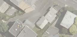
1 TION OVEVIEW & TIMELINE Introduction Development Stages Stage ENBLING WOKS uckland Transport is developing a station for Parnell, adjacent to the Mainline Steam workshops to the east of uckland Domain and adjacent to Cheshire Street (referred to as the Mainline Steam site). The station will service and integrate both the residential and commercial Parnell communities, and the surrounding areas of interest. The project seeks to: Create a high quality rail station with strong direct connections to key catchments including Parnell Village, the uckland War Memorial Museum, uckland University, and Carlaw Park; Create a high quality heritage destination focused around the old Newmarket Station which will be relocated to the site; and Create a fully integrated precinct that promotes improved connections and access. The project will be developed in two stages. FO FUTHE ENQUIIES CONTCT: uckland Transport Phone Stage will involve enabling works to be undertaken in the / Christmas period, when train services will be stopped (referred to as a block-of-line). The enabling works are required to facilitate the future station construction. These works include: Earthworks to lower the track in order to achieve the appropriate grade for station platforms; etaining structures and/or batter slopes; Track realignment to accommodate the station platforms. elocation of the existing underpass which provides access to/from uckland Domain, in order to maintain existing pedestrian access. Stage TION ME PLN ND CONUCTION Stage will involve the development of the station masterplan and construction of the new Parnell ailway Station, due to be undertaken in /. These works will generally involve: The construction of two station platforms located to the northeast of the Mainline Steam building. elocation of the old Newmarket Station and associated signal box to the site. New pedestrian connections and pathways. Landscaping and planting. uckland CBD lbert Park Parnell University The Domain Station Development Timeline ENBLING WOKS MEPLN DEVELOPMENT TION DESIGN TION CONUCTION MEPLN IMPLEMENTTION December January May ugust Track lowering + retaining New underpass Services upgrade Community & stakeholder consultation Masterplan design Design / Engineering Cost analysis New Side platforms Newmarket Station located Platform shelters Lifts + bridge th November


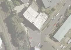


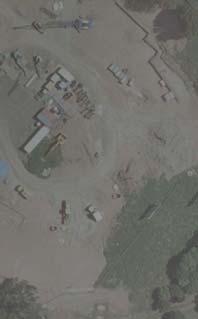


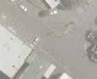
2 PNELL TION ENBLING WOKS P Formation of underpass lowering and construction Main line steam NE LL ISE HE T HE E K CLW PK E E O T HWOKS E IS LL E INING W W LLS NE ON LC F T CK CENTELINE P Services SEWE MNHOLE OMW W TE MNHOLE OMW W TE CEEK KIWIIL SIGNL DT T THE DOMIN WTEMIN OMW W TE SEWE T/ T FX CBLE CE E E H NG TEL CLE TEL NEW DUCT T NEW DUCT KIWIIL FIBE Key Plan Section - Underpass th November


 because of the scale, complexity, and track and signalling activities.")
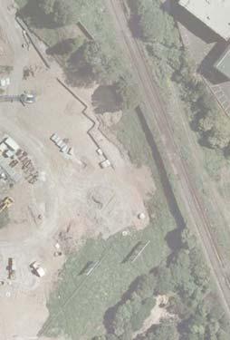
3 ENBLING WOKS Construction Outline The proposed enabling works at the site are required in order to achieve a : grade on future platforms associated with a new Parnell ailway Station. The works will involve: Track lowering along the existing corridor Two retaining walls are required on the western side of the rail corridor Batter slopes are required on both the eastern and western side of the rail corridor e-confi guration of the Mainline Steam track infrastructure; The removal of the existing precast concrete pipe underpass, due to the depth of the track lowering extending into the structure. The construction of a new underpass to the north of the existing underpass, some m in length and. m wide, with a clearance of. m; and Earthworks are required in order to undertake the track lowering and retaining structures. These works require a major block-of-line (BOL no trains running on this section of line) because of the scale, complexity, and track and signalling activities. The next available opportunity to undertake works during a BOL is during the / Christmas period. Track lowering The track lowering will involve: Dismantling the existing rails and sleepers to stockpile within the rail corridor; emoving ballast (aggregates) to a depth of approximately mm stockpiling within the rail corridor. Excavating additional cut to the subgrade level of up to.m from the top of the existing rail level; Constructing formation using GP; Check grade / level/ cross-fall; Lay ballast aggregate to a depth of approximately mm; and ssemble and lay rail track to the position, level and grade. emoval of existing underpass The removal of the existing underpass is required to facilitate track lowering. This work will involve: Lowering the track formation down to mid culvert height, then cut down the existing underpass culvert at mid height and remove the wing walls; Pedestrian access to/from uckland Domain will be maintained throughout the period of works via the existing underpass and/or a temporary rail crossing. Construction of new underpass new underpass will be constructed works which will involve: Excavating to the level of the underpass for subgrade preparation; Construction of underpass involving precast concrete wing walls and precast concrete box units; Water proofi ng the sections prior to backfi lling and constructing the rail support and track. Earthworks Signifi cant earthworks is required to be undertaken in order to lower the existing tracks. Construction earthworks will generally involve: Excavating soils to form suitable slopes; Placement of structural fi ll, where required; Backfi lling retaining walls with compacted granular fi ll. D UNDEPSS NEW UNDEPSS LOCTION PNELL B-B DIL TO BE CONFIMED WITHUCKLND COUNCIL PKS DOMIN TYPICL B-B COSS-SECTION th November


4 MEPLN OPPOTUNITIES uckland Transport Vision The design of the Parnell Station Precinct and Station has set out to achieve the following key objects: high quality rail station with strong direct connections to key catchments including Parnell Village, the uckland War Memorial Museum, uckland University, and Carlaw Park. high quality cultural and heritage destination focused around a new Parnell Station that integrates the old Newmarket Station building. robust and fully integrated precinct structure that promotes the mixed use urban development and intensification of adjacent under utilised brown field land. Station Precinct Design Philosophy The design for the Parnell Station Precinct responds to the following key design drivers: Place making Creation of a high quality cultural and heritage destination focused around a new Parnell Station that integrates the old Newmarket Station building. Encourage Public Transport Creating a built form that encourages people to ride public transport more often. Neighbourhood Cohesion Integration of Parnell with the Carlaw Park site across the rail corridor and the University beyond. Integration of Parnell with the Domain and uckland War Memorial Museum across the rail corridor. Community evitalisation Mixed use urban development and intensifi cation of brown fi elds land. Conservation daptive re-use and conservation of the old rail workshops daptive re-use and conservation of the old Newmarket Station building Public Safety ctivate precinct and foster movement and presence. Create built in security throughout the day with the presence of diverse/multi-use occupants. Connectivity & Integration LOWE PNELL Objective: To create strong direct connections integrating the station to its very catchment UNIVESITY To develop connections that create a robust and fully integrated precinct structure esponse: Primary Connection through Carlaw Park development site to the university Connection to lower Parnell Connection up to the heart of Parnell Village via karoa Street. Connection through Ngahere Terrace to upper village Secondary Connection to the Domain from adjacent residential neighbourhood Connection with Parnell oad Connection to the Domain and Museum. Connection from Cracroft Street to the Domain & uckland Museum Connection down Heather Street to Stanley Street The Domain MID PNELL Primary Connection Secondary Connection UPPE PNELL evitalisation and Place Making LOWE PNELL Objective: To use the station as a catalyst to create a high quality, unique, identifi able and active place within Parnell. UNIVESITY To use the rail station as a catalyst for mixed use urban development and intensifi cation on brown fi eld sites esponse: MID PNELL Proposed New Station Platforms Station plaza surrounded by active and inhabited buildings Nicholls Lane Station Entry Plaza surrounded by active inhabited edges. The Domain Possible development opportunities Newmarket Station Building integrated into the new Parnell Station. Mainline Steam Workshops Station entry and pedestrian bridge Connections UPPE PNELL th November


5 TION OVEVIEW- CONCEPT Station Plan - Concept Station Platforms Old Newmarket Station Building Pedestrian Bridge with Stair and Lift access Mainline Steam Workshops Potential Nicholls Lane Extension Carlaw Park Development Station Plaza Station erial View Station Platforms Old Newmarket Station Building Pedestrian Bridge with Stair and Lift ccess Mainline Steam Workshops Potential Nicholls Lane Extension Carlaw Park development Station plaza Potential Station access road upgrade Underpass Station erial View Station Platforms Old Newmarket Station Building Pedestrian Bridge with Stair and Lift ccess Mainline Steam Workshops Potential Nicholls Lane Extension Carlaw Park development Station plaza Potential Station access road upgrade Underpass th November
John M. Fleming Managing Director, Planning and City Planner. Old East Village Dundas Street Corridor Secondary Plan Draft Terms of Reference
 Report to Planning and Environment Committee To: From: Subject: Chair and Members Planning & Environment Committee John M. Fleming Managing Director, Planning and City Planner Old East Village Dundas Street
Local Growth Planning in North Central Green Line Communities
 2018 April 30 Page 1 of 6 EXECUTIVE SUMMARY This report outlines a high-level scope for local growth planning for north central Green Line communities. The catalyst for this review is the significant investments
GO Station Mobility Hubs: Draft Precinct Plans. Committee of the Whole July 12, 2018
 GO Station Mobility Hubs: Draft Precinct Plans Committee of the Whole July 12, 2018 Purpose of this Workshop Present Draft Precinct Plans for the 3 GO Station Mobility Hubs Continue the conversations that
Port Credit Local Advisory Panel October 20 th Meeting
 Port Credit Local Advisory Panel October 20 th Meeting Focus Of This Evening s Meeting: 1. Hurontario Main Street Higher Order Transit Study 2. Port Credit Mobility Hub & GO Station Parking Structure Study
West Gate Tunnel Project. Incorporated Document May Incorporated document pursuant to section 6(2)(j) of the Planning and Environment Act 1987.
(j) of the Planning and Environment Act 1987.") West Gate Tunnel Project Incorporated Document May 2017 Incorporated document pursuant to section 6(2)(j) of the Planning and Environment Act 1987. Drafting Note: The planning control contained in this
West Gate Tunnel Project Incorporated Document May 2017 Incorporated document pursuant to section 6(2)(j) of the Planning and Environment Act 1987. Drafting Note: The planning control contained in this
MICHAELS AVE RESERVE. Draft Concept Plan of South Section September Contents. 1 Project Background. 2 Masterplan Timeline
 MICHAELS AVE ESEVE Draft Concept Plan of South Section September 05 Contents Project Background Masterplan Timeline Photographic Analysis Option A - Updated Masterplan 5 Option B - Alternative Design 6
Executive Summary. NY 7 / NY 2 Corridor
 Executive Summary NY 7 / NY 2 Corridor Transportation and Land Use Study December 2005 Prepared for: Town of Colonie Capital District Transportation Committee Prepared by: Introduction: Land use decisions
Task Force on Kai Tak Harbourfront Development. Station Square at Kai Tak
 For discussion on 24 February 2017 Station Square at Kai Tak PURPOSE This paper seeks Members views on the design of the Station Square at Kai Tak. BACKGROUND 2. Upon the relocation of the Hong Kong International
St. Clair Avenue West Area Transportation Master Plan
 1 (Between Keele Street and Old Weston Road) Public Information Centre 1 December 2, 2015 2 Welcome Welcome to the first Public Information Centre for the St. Clair Avenue West Area. The panels will present
Chapter 2: OUTLINE PLANNING APPLICATION PROPOSALS. A New Garden Neighbourhood Matford Barton 17
 Chapter 2: OUTLINE PLANNING APPLICATION PROPOSALS A New Garden Neighbourhood Matford Barton 17 2.1. SUMMARY AND STATUS OF THE PROPOSALS 2.1.1. The parameter plans and associated wording in this chapter
SUBJECT: GO Station Mobility Hubs Preferred Concepts: Aldershot GO, Burlington GO and Appleby GO. Planning and Development Committee - Public Meeting
 Page 1 of Report PB-76-17 SUBJECT: GO Station Mobility Hubs Preferred Concepts: Aldershot GO, Burlington GO and Appleby GO TO: FROM: Planning and Development Committee - Public Meeting Planning and Building
CITY OF VAUGHAN KIRBY GO TRANSIT HUB SUB-STUDY
 WELCOME! Thank you for attending, and welcome to the first of three Public Meetings for the Kirby GO Transit Hub Study. Your feedback is important to us, and will help inform the development of the draft
HOROWHENUA DEVELOPMENT PLAN June create a safe crossing for children moving to and from the school and other areas. 7.8 Ohau
 7.8 Ohau create a safe crossing for children moving to and from the school and other areas. Ohau has a traditional village form with a collective of school, church and reserve at the main road intersection.
Northwest Rail Corridor and US 36 BRT Development Oriented Transit Analysis 4.4 STATION AREA FINDINGS
 4.4 STATION AREA FINDINGS Each station is different, and each one requires a separate set of recommendations based on the vision for the site. This section outlines an initial TOD strategy and recommendations
Animating the Rideau Canal December 2013
 Executive Summary Animating the Rideau Canal December 2013 Why study the Rideau Canal? The Rideau Canal has been an important part of Ottawa throughout its history, and has shaped and been shaped by the
Mount Dennis Mobility Hub Study Public Meeting December 12 th, :30pm 9:30pm York Memorial Collegiate, Cafeteria 2690 Eglinton Avenue West
 Mount Dennis Mobility Hub Study Public Meeting December 12 th, 2012 6:30pm 9:30pm York Memorial Collegiate, Cafeteria 2690 Eglinton Avenue West MEETING SUMMARY On December 12 th, 2012, over 89 people participated
New Westminster Downtown Parking Strategy Public Open House #1 September 13, 2012
 New Westminster Downtown Parking Strategy Public Open House #1 September 13, 2012 The City is preparing a strategy for parking in Downtown New Westminster. The study team and a group of key stakeholders
George Hotel application
 George Hotel application STAFF REVIEW FORM AND CHARACTER COMMITTEE OF THE WHOLE MARCH 25, 2014 Presentation Outline Purpose: Council direction on proposed form and character to inform drafting of the zoning
ELMVALE ACRES SHOPPING CENTRE MASTER PLAN
 ELMVALE ACRES SHOPPING CENTRE MASTER PLAN Contents 1.0 INTRODUCTION... 2 2.0 LOCATION... 2 3.0 EXISTING CONTEXT... 2 4.0 VISION & GUIDING PRINCIPLES... 2 5.0 LAND USE AND BUILT FORM... 4 5.1 St. Laurent
11 GUIDING PRINCIPLES:
 11 GUIDING PRINCIPLES: CATEGORIES FIVE GUIDING PRINCIPLE CATEGORIES The Policy Statement will contain a set of Guiding Principles to inform the urban design and sustainability objectives for the site.
8.0 Design and Form of Development 43/
 42/ 8.0 Design and Form of Development 43/ Rothwells Farm, Golborne/ Development Statement Figure 7. Site Constraints Key 44/ Site Boundary 360 Bus Route/Stops Existing Trees Underground Water Pipe Sensitive
Johnson Street Bridge Public Realm Update
 Johnson Street Bridge Public Realm Update August 20, 2015 Background Johnson Street Bridge Replacement Project impacts a diverse range of stakeholders In addition to a new bridge, the project also includes
FROM DUPONT CIRCLE NORTH TO CALIFORNIA STREET, NW. Welcome!
 FROM DUPONT CIRCLE NORTH TO CALIFORNIA STREET, NW Welcome! Meeting Agenda 6:00 PM Open House 6:30 PM Presentation 7:00 PM Open House / Q&A at the Boards Project Design Team Connecticut Avenue, NW Project
Queensborough Eastern Neighbourhood Node. Community Open House
 Queensborough Eastern Community Open House The Vision The Queensborough Eastern will become the heart of eastern Queensborough. Through a sensitive mix of viable commercial and residential areas, the neighbourhood
3.5 Principle 5/Response
 5 Principle 5/Response Existing street network Proposed street network Pedestrian street hierarchy Existing streets Existing Regional Arterial 4 Existing Street Network Existing and proposed streets Indicative
B2B Project Team Responses to Nga Potiki Draft Addendum
 B2B Project Team s to Nga Potiki Draft Addendum Nga Potiki were introduced into the project in December 2012 and formally meet through the Hapū Advisory Group (Nga Potiki, Ngai Tukairangi and Ngati Tapu)
SUBJECT: Proposed Downtown Mobility Hub Precinct Plan and Proposed Official Plan Policies
 Page 1 of Report PB-81-17 SUBJECT: Proposed Downtown Mobility Hub Precinct Plan and Proposed Official Plan Policies TO: FROM: Committee of the Whole Planning and Building Department Report Number: PB-81-17
Overall Map. Chicago. St. Louis. Summit. Joliet. Dwight. Pontiac. Bloomington-Normal Lincoln. Springfield. Carlinville. Alton EXPERIENCE IT YOURSELF.
 Overall Map Summit Chicago Bloomington-Normal Lincoln New Station Planned New Station Planned Dwight Pontiac Joliet Pedestrian overpass and second platform planned Higher speed service began in this section
Redevelopment of Ajax Plaza Area Public Open House Meeting February 19, 2015 Questions and Answers
 Redevelopment of Ajax Plaza Area Public Open House Meeting February 19, 2015 Questions and Answers Redevelopment of Ajax Plaza Area Why is the redevelopment of the Ajax Plaza important to the revitalization
Adelaide Street / Canadian Pacific Railway (CPR) Grade Separation Class Environmental Assessment. Public Information Centre 3
 Grade Separation Class Environmental Assessment. Public Information Centre 3") 1 Adelaide Street / Canadian Pacific Railway (CPR) Grade Separation Study Process and Purpose of PIC 3 2 Study Commencement February 2016 Phase 1: Problem and Opportunity Identify problems and opportunities
1 Adelaide Street / Canadian Pacific Railway (CPR) Grade Separation Study Process and Purpose of PIC 3 2 Study Commencement February 2016 Phase 1: Problem and Opportunity Identify problems and opportunities
The Master Plan Framework
 The Master Plan Framework The East Harbour Master Plan advances the development of 60 acres of former industrial lands east of the Don River. The Master Plan outlines a vision for a vibrant, transit-oriented
LEED-ND 101: Practical Strategies for Achieving Sustainability Goals. Travis Parker Lakewood Planning Director
 LEED-ND 101: Practical Strategies for Achieving Sustainability Goals Travis Parker Lakewood Planning Director Metro Vision Idea Exchange Oct 11, 2012 West Corridor Stations West Corridor Overview West
Welcome. Green Line LRT. Beltline Alignment Options. Stay engaged! Follow the Green Line story at calgary.ca/greenline
 Welcome Green Line LRT Beltline Alignment Options Stay engaged! Follow the Green Line story at calgary.ca/greenline Green Line LRT Why are we here? Our Challenge Determine the best alignment in the Beltline.
Town Center (part of the Comprehensive Plan)
") Town Center (part of the Comprehensive Plan) Mercer Island Town Center Looking North (2014) In 1994, a year-long process culminated in a set of design guidelines and code requirements for the Town Center
Town Center (part of the Comprehensive Plan) Mercer Island Town Center Looking North (2014) In 1994, a year-long process culminated in a set of design guidelines and code requirements for the Town Center
LUNDY S LANE COMMUNITY IMPROVEMENT PLAN STUDY
 PUBLIC INFORMATION MEETING #2 October 12, 2016 LUNDY S LANE COMMUNITY IMPROVEMENT PLAN STUDY AGENDA 5:00 to 5:30pm: Open House 5:30 to 6:15pm: Presentation 6:15 to 7:00pm: Individual paced workshop with
TOWN COUNCIL / PLANNING COMMISSION
 Workshop #3 TOWN COUNCIL / PLANNING COMMISSION January 20, 2011 Consultant Team In Attendance Tonight BMS Design Group Nevada City and San Francisco Michael Smiley, AICP, ASLA Partner-in-Charge Nancy L.
0 9 Areas of Change 59
 09 Areas of Change 59 09 Areas of Change This section explores seven areas of change within Solihull Town Centre which provide practical interventions in order to deliver the emerging concepts outlined
The West Vaughan Employment Area Secondary Plan Policies
 Part 2: The West Vaughan Employment Area Secondary Plan Policies 2.1 General Policies It is the policy of Council: 2.1.1. That the West Vaughan Employment Area (the WVEA), identified on Schedule 1, will
Union Station Master Plan Task 2 Briefing
 Union Station Master Plan Task 2 Briefing Goals and Organization for Tonight s Meeting Presentation Master Plan Schedule and Scope Key Findings Guiding Principles Alternatives Process Draft Alternatives
South District What we heard
 What we heard Vision to 2056 and Priorities Governance and implementation Infrastructure and funding Feedback supported: The vision for a metropolis of three cities, but emphasised the importance of infrastructure
Tāhuhu whakaruruhau ā-taone The sheltering ridge pole
 B2. Tāhuhu whakaruruhau ā-taone - Urban growth and form B2.1. Issues Tāhuhu whakaruruhau ā-taone The sheltering ridge pole Auckland s growing population increases demand for housing, employment, business,
Urban Design Review Panel Submission. The Ottawa Train Yards - Office Development. 405 Terminal Avenue. 17 April Table of Contents.
 Table of Contents PHOTOGRAPHS OF EXISTING SITE CONDITION URBAN DESIGN BRIEF PART A: Summary and Response to City Urban Design Guidelines and Policies PART B: Site Specific Urban Design Objectives PART
28. Coolaney-Rockfield Mini-Plan
 28. Coolaney-Rockfield Mini-Plan 28. Coolaney-Rockfield Mini-Plan Community facilities Community facilities in Coolaney-Rockfield consist of a primary school, crèche, community centre, sports field and
PART 1. Background to the Study. Avenue Study. The Danforth
 The Danforth 1.1/ Study Purpose & Key Municipal Goals 1.2/ The Local Advisory Committee 1.3/ The Project Team 1.4/ Study Process/Summary of Method 1.5/ Summary of Consultation 1.1 Study Purpose and Key
New-Cast Mixed-use Development Proposal King Street West, Newcastle, Ontario
 URBAN DESIGN BRIEF New-Cast Mixed-use Development Proposal King Street West, Newcastle, Ontario TABLE OF CONTENTS: 1.0 Executive Summary 2.0 Creating Vibrant and Sustainable Urban Places: Excerpts from
Pedestrian Project Award Institute of Transportation Engineers
 Pedestrian Project Award Institute of Transportation Engineers Rideau Canal Pedestrian Crossing Planning and Environmental Assessment Report The Setting The Rideau Canal and its adjacent pathways are highly
burlington mobility hubs study Downtown Burlington Mobility Hub
 burlington mobility hubs study Downtown Burlington Mobility Hub Draft Precinct Plan Workbook PIC #3, September 7, 2017 downtown mobility hub objectives City staff and their consultants are proposing an
PUBLIC OPEN HOUSE HURONTARIO-MAIN CORRIDOR SECONDARY PLAN
 PUBLIC OPEN HOUSE HURONTARIO-MAIN CORRIDOR SECONDARY PLAN Tuesday, February 28, 2012 6pm 9pm 1 st Floor Atrium, City Hall 2 Wellington Street West, Brampton 1 POLICY FRAMEWORK The 2006 Provincial Growth
Fossumdumpa Stovner, Oslo
 Fossumdumpa Stovner, Oslo The site is part of a larger area of 25.000 sqm called Fossumdumpa, which is located in the center of Stovner district and situated in the Grorud Valley in the eastern part of
Mark-up of the effect of the proposed Bronte Village Growth Area OPA No.18 on the text of section 24, Bronte Village, of the Livable Oakville Plan
 Mark-up of the effect of the proposed Bronte Village Growth Area OPA No.18 on the text of section 24, Bronte Village, of the Livable Oakville Plan Notes: This document is provided for information purposes
Tauranga City Centre Spatial Framework
 Tauranga City Centre Spatial Framework Stakeholder Engagement Workshop 15 October 2015 Project Design Team Beca & LandLAB Our team Henry Crothers (LandLab) Landscape Architect/Urban Designer Urban and
OUR GREATER SYDNEY A metropolis of three cities. OVERVIEW. connecting people. DRAFT Greater Sydney Region Plan
 OUR GREATER SYDNEY 2056. A metropolis of three cities. OVERVIEW. connecting people. DRAFT Greater Sydney Region Plan October 2017 This document is an overview of the draft Greater Sydney Region Plan. To
Building the transportation network we need for the future
 Building the transportation network we need for the future WHO IS METROLINX? Metrolinx was created in 2006 by the Province of Ontario with a mandate to create greater connection between the communities
WELCOME. Land North of STEVENAGE. We would like to thank you for attending our public exhibition today.
 WELCOME We would like to thank you for attending our public exhibition today. The purpose of this event is to share our proposals and hear your thoughts on our ideas. Members of the project team are on
Chapter 9 Route window W18 Slough station. Transport for London
 Chapter 9 Route window W18 Slough station Transport SLOUGH STATION 9 Route window W18 Slough station 9.6 Wexham Road bridge worksite north; and Wexham Road bridge worksite south. Uxbridge Road bridge
SH1 link to Matakana Road
 Future transport network for Warkworth Warkworth is expected to grow to a substantial satellite town of more than 20,000 people over the next few decades. To meet this anticipated growth, around 1,000
CREATE A VIBRANT MIXED-USE COMMUNITY
 CREATE A VIBRANT MIXED-USE COMMUNITY Land Use Public Realm Plan Built Form Heritage Tell us what you think! Place a sticky note here or leave us a comment form LAND USE The land use framework of this Secondary
Project Output Indicators for Federal Gas Tax Investments
 Municipalities are required to report results achieved through the investment of federal Gas Tax funds under the Municipal Funding Agreement. AMO uses the indicators listed below to capture the outputs
NO: R035 COUNCIL DATE: FEBRUARY 24, 2014
 CORPORATE REPORT NO: R035 COUNCIL DATE: FEBRUARY 24, 2014 REGULAR COUNCIL TO: Mayor & Council DATE: February 24, 2014 FROM: General Manager, Planning and Development FILE: 6520-01 SUBJECT: Town Centre
I539. Smales 2 Precinct
 I539. Smales 2 Precinct I539.1. Precinct Description The Smales 2 Precinct applies to a 4.8 hectare block of land located on the southern side of Northcote Road and fronting Lake Pupuke, Takapuna. The
Public input has been an important part of the plan development process.
 Lakewood s Comprehensive Plan recognizes that transportation helps shape the community, and that the way the community provides for the safe and efficient movement of people affects the character of the
CANOPY AT AMSTEL (THE AMSTEL GOLF COURSE REDEVELOPMENT)
") CANOPY AT AMSTEL (THE AMSTEL GOLF COURSE REDEVELOPMENT) 1000 CRANBOURNE FRANKSTON ROAD, CRANBOURNE The former Amstel Golf Course was rezoned to a General Residential Zone in 2015 to facilitate its redevelopment
CANOPY AT AMSTEL (THE AMSTEL GOLF COURSE REDEVELOPMENT) 1000 CRANBOURNE FRANKSTON ROAD, CRANBOURNE The former Amstel Golf Course was rezoned to a General Residential Zone in 2015 to facilitate its redevelopment
4 RESIDENTIAL ZONE. 4.1 Background
 4 RESIDENTIAL ZONE 4.1 Background The residential areas within the City are characterised by mainly lowrise dwellings sited on individual allotments. Past architectural styles, settlement patterns and
Downtown Sudbury. Implementation Plan. City Council
 Downtown Sudbury Implementation Plan City Council 08.14.12 Thirty Year Master Plan 18 Projects: Retail Strategy and Growth Friendship Centre Retrofit Place des Arts Franklin Carmichael Art Gallery Farmers
Expo Line Transit Project. Project Status Update Meeting West End Corridor Segment C
 Exposition Light Rail Transit Project Project Status Update Meeting West End Corridor Segment C Culver City Senior Center November 18, 2010 Phase 1 Project Description Phase 1 from Downtown Los Angeles
2017 Canadian Consulting Engineering Awards
 2017 Canadian Consulting Engineering Awards Northeast Anthony Henday Drive DBFO Edmonton, Alberta Four years of detours, traffic snarls, varying speed limits, and stop-and-start driving has come to an
Capital works Curtin group centre - central plaza Infrastructure and public space improvements may be
 1 Introduction How is a master plan implemented? When a master plan is finished, the following generally occurs. What is a master plan? A master plan is not a detailed design, but: a process that defines
Plan Modification to Chapter B2 of the Auckland Unitary Plan(AUP) Operative in part (15 November 2016)
 Operative in part (15 November 2016)") UNITARY PLAN UPDATE REQUEST MEMORANDUM TO FROM Phill Reid Linley Wilkinson DATE 25 September 2018 SUBJECT Plan Modification to Chapter B2 of the Auckland Unitary Plan(AUP) Operative in part (15 November
UNITARY PLAN UPDATE REQUEST MEMORANDUM TO FROM Phill Reid Linley Wilkinson DATE 25 September 2018 SUBJECT Plan Modification to Chapter B2 of the Auckland Unitary Plan(AUP) Operative in part (15 November
Welcome to the Sellwood Bridge Project Pre-Construction Open House
 Welcome to the Sellwood Bridge Project Pre-Construction Open House 5:30 7:30 p.m. Please sign in here Information stations and project staff are located throughout the room. Goals for Tonight s Meeting
City of Ennis. Downtown Master Plan Catalyst Projects
 City of Ennis Downtown Master Plan Catalyst Projects Revised Framework Plan REVISED Project Types and Descriptions Project Types A. Visitor Attracting Projects: Projects in this category are intended to
Rapid Transit Implementation Working Group September 14, 2017
 Rapid Transit Implementation Working Group September 14, 2017 BACKGROUND Council approved the Rapid Transit Master Plan and Updated Business Case on July 25, 2017. Approval of the RTMP confirmed the BRT
Stadium District Masterplan
 Stadium District Masterplan Masterplan (noun): an evolving long-term planning document that establishes the framework and key elements of a site. It reflects a clear vision synthesizing developer goals
BETTER PUBLIC TRANSPORT PROJECT WATERBEACH TO SCIENCE PARK AND EAST CAMBRIDGE CORRIDORS
 Report To: Greater Cambridge Partnership Joint Assembly 20 th September 2018 Lead Officer: Peter Blake GCP Director of Transport BETTER PUBLIC TRANSPORT PROJECT WATERBEACH TO SCIENCE PARK AND EAST CAMBRIDGE
Euston Area Plan - Examination: Statement in response to the Inspector s Matters, Issues and Questions
 1 Euston Area Plan - Examination: Statement in response to the Inspector s Matters, Issues and Questions Sydney and London Properties Limited June 2014 2 3 This document is the Statement in response to
6 BRIDGES. 6.1 Design philosophy. Proposed bridges
 SECTION 6 BRIDGES 6 BRIDGES Throughout the Project, bridges are a key visual element and marker for road users, pedestrians and cyclists. The design of bridges, as with other visible structures, has been
Welcome to the Public Consultation Exhibition
 Welcome to the Public Consultation Exhibition Today is your opportunity to: Speak to the team Learn more about the project Leave feedback on the plans The Secretary of State for Transport has recognised
Public Open House. Overview of the Downtown Plan Official Plan Amendment April 23, 2018
 Public Open House Overview of the Downtown Plan Official Plan Amendment April 23, 2018 1 A 25-Year Plan for Downtown To ensure growth contributes positively to Toronto s Downtown as a great place to live,
1. Welcome. Background
 1. Welcome The purpose of this exhibition is to provide you with an update on progress on the Kilnwood Vale Scheme. In order to improve the scheme and deliver key facilities earlier in the development,
Lakeview and Port Credit District Policies Review Public Engagement Process
 Lakeview and Port Credit District Policies Review Public Engagement Process Brook McIlroy Planning + Urban Design/PACE Architects MSAi Architects Poulos and Chung Transportation Engineers December 11,
URBAN DESIGN ACTION PLAN. Community Design and Environmental Services Committee April 20, 2009
 URBAN DESIGN ACTION PLAN Community Design and Environmental Services Committee April 20, 2009 What is the Urban Design Action Plan? The Action Plan is a guiding document to address how design-thinking
I615. Westgate Precinct
 I615. Westgate Precinct I615.1. Precinct Description The Westgate Precinct is located approximately 18km west of the Auckland city centre. There are seven Sub-precincts in the Westgate Precinct: Sub-precinct
Planning for the Future Urban Area. in north Markham. Update. Development Services Committee. December 9, De Development Services Committee
 Planning for the in north Markham 1 Update De December 9, 2014 Overview - Growth Management Strategy and new Official Plan 2014 Status - Official Plan 2014 and ROPA3 Update - Planning for the Future Urban
Building out the Regional Growth Strategy in Surrey: a Strong Centre & a Connected Transit City
 Building out the Regional Growth Strategy in Surrey: a Strong Centre & a Connected Transit City Surrey in the Metro Vancouver Region Regional Growth Strategy identifies Surrey as a major provider of housing
THREE KINGS RENEWAL DESCRIPTION OF URBAN DESIGN / ARCHITECTURAL ELEMENTS AND PROCESS. prepared by dko Architecture
 THREE KINGS RENEWAL DESCRIPTION OF URBAN DESIGN / ARCHITECTURAL ELEMENTS AND PROCESS prepared by dko Architecture THESE PLANS OUTLINE THE VISION OF FLETCHER RESIDENTIAL LTD AND ARE NOT ENDORSED BY AUCKLAND
Adelaide Street / Canadian Pacific Railway (CPR) Grade Separation. Public Information Centre #1
 Grade Separation. Public Information Centre #1") 1 Adelaide Street / Canadian Pacific Railway (CPR) Why Are We Here? 2 The purpose of Public Information Centre (PIC) #1 is to: Introduce the study Provide the study background and context Identify the
1 Adelaide Street / Canadian Pacific Railway (CPR) Why Are We Here? 2 The purpose of Public Information Centre (PIC) #1 is to: Introduce the study Provide the study background and context Identify the
Kanata Light Rail Transit Planning and Environmental Assessment Study
 Kanata Light Rail Transit Planning and Environmental Assessment Study Public Open House #2 Transportation Services Department December 7, 2017 Agenda Review study progress Confirm the Preferred Corridor
3. Endorse the LRT vision in transforming Surrey into Connected-Complete-Livable communities, and more specifically, the official vision statement:
 CORPORATE REPORT NO: R038 COUNCIL DATE: February 20, 2017 REGULAR COUNCIL TO: Mayor & Council DATE: February 16, 2017 FROM: General Manager, Engineering FILE: 8740-01 SUBJECT: Surrey Light Rail Transit
As will be detailed, our site plays a strategic role in providing these opportunities.
 29 March 2017 Greater Sydney Commission PO Box 257 Parramatta NSW 2124 Email: info@gsc.nsw.gov.au Dear Sir/Madam, RE: DISTRICT PLAN-SOUTH WEST AREA. Woodward Park and Liverpool CBD. I have been requested
Thanks for attending this information session about plans to provide new housing, open space and community facilities at North Eveleigh.
 Welcome Thanks for attending this information session about plans to provide new housing, open space and community facilities at North Eveleigh. We received your feedback on an initial concept in late
GLEN ROAD PEDESTRIAN BRIDGE ENVIRONMENTAL ASSESSMENT STUDY PUBLIC INFORMATION CENTRE #2 OCTOBER 24, 2017
 GLEN ROAD PEDESTRIAN BRIDGE ENVIRONMENTAL ASSESSMENT STUDY PUBLIC INFORMATION CENTRE #2 OCTOBER 24, 2017 Glen Road Pedestrian Bridge Class Environmental Assessment 1 WELCOME! Welcome to the second Public
South Yonge Street Corridor
 South Yonge Street Corridor Streetscape Master Plan Study Draft Final Executive Summary Prepared by: January 2012 In Partnership with: Introduction The Future... Yonge Street is at the forefront of York
THE TOWN OF WASAGA BEACH
 THE TOWN OF WASAGA BEACH Downtown Development Master Plan Committee of the Whole Presentation January 26 th 2017 Uses within this designation should reflect a dependence on tourism as opposed to the permanent
BRIDGE OF DON MASTERPLAN & PLANNING SUMMARY
 BRIDGE OF DON MASTERPLAN & PLANNING SUMMARY SITE LOCATION The site of the existing AECC lies in an area of predominately residential and business use in Bridge of Don and extends approximately 50 acres.
heuston gateway: sections heuston gateway: regeneration strategy and development framework plan
 B B1 A B1 B C A heuston gateway: sections B B1 C 117 4.3.3 Zoning The station is the central hub of the area and this function must be preserved and developed. However large areas of the Heuston Station
DRAFT Land Use Chapter
 Stevens Creek Urban Village DRAFT 1 18 17 Land Use Chapter INTRODUCTION This Land Use Chapter describes how the Stevens Creek Urban Village will accommodate the growth that is planned for it in the Envision
TREE GUARDS AND EDGING
 CUSTOM BENCHES TREE GUARDS AND EDGING DETECTABLE WARNING PLATES Custom Bench with Rail Spikes (inset into concrete, wood bench seat) Custom Bench with Rail Wheel (inserted into end of bench) Tree guards
The Project. In 2013, construction was completed between 100 Street and 102 Street.
 The Project Jasper Avenue New Vision (JANV) is a major catalyst project identified in the Capital City Downtown Plan (2010) between 92 Street and 109 Street, including the streets half a block north and
Michigan State University Barrier-Free/Accessibility Project Status Summary March 2017
 Projects Completed FY14, FY15 and FY16 (arranged alphabetically) Abrams Planetarium Install automatic door opener on main doors of the Planetarium. Completed: Summer 2016 Cost: $13,000 Akers Hall Renovations
Evaluation Criteria. Detailed Evaluation Criteria
 Evaluation Criteria Detailed Evaluation Criteria Community Well-being A safe and socially inclusive service that improves access to key community destinations and provides transportation choices for Calgarians.
I209 Quay Park Precinct
 I209. Quay Park I209.1. Precinct description The Quay Park Precinct is located on reclaimed land at the eastern end of the city centre and along the City Centre waterfront. It is dissected to the east