United States Department of the Interior National Park Service
|
|
|
- Stanley McGee
- 5 years ago
- Views:
Transcription
1 NPS Form (Rev. 8-86) OMB No United States Department of the Interior National Park Service NATIONAL REGISTER OF HISTORIC PLACES REGISTRATION FORM other name/site number: Camp Rhododendron Recreational Historic District not for publication: N/A city/town: Morqantown vicinity: state: county: Mononqalia code: 061 zip code: Category Property : District Number of Resources within Property: Contributing Noncontributing 2 buildings sites structures objects 2 Total Number of contributing resources previously listed in the National Register: N/A Name of relate property listing: Coopers Rock State Forest Historic Resources
2 State/Federal Agency Certification... As the designated authority under the National Historic Preservation Act of 1986, as amended, I hereby certify that this nomination - request for detemination of eligibility meets the documentation standards for registering properties in the National Register of Historic Places and meets the procedural and professional requirements set forth in 36 CFR Part 60. In my opinion, the property X meets - does not meet the National Register Criteria. - See continuation sheet. '7 Signature of ~ertirying Qfficial bd LL, / Grd Date State or Federal agency and bureau In my opinion, the property meets does not meet the National Register criteria. - See continuation sheet. Signature of commenting or other official Date State or Federal agency and bureau I, hereby certify that this property is: entered in the National Register - See continuation sheet. determined eligible for the National Register - See continuation sheet. determined not eligible for the National Register removed from the National Register other (explain): Signature of Keeper Date of Action Current : Recreation and Culture Sub: State Forest
3 7. Description Architectural Classification: See Below Other Description: Other: NPS Rustic Architecture Materials: foundation Sandstone roof Wood shinale; walls Wood-loq asphalt shinqle Stone other Describe present and historic physical appearance. sheet. See continuation 8. Statement of Significance Certifying official has considered the significance of this property in relation to other properties: State Applicable National Register Criteria: A, C Criteria Considerations (Exceptions) : N/A Areas of Significance: Architecture Entertainment/Recreation Landscape Architecture Conservation Period(s) of Significance: w Significant Dates : Significant Person(s): Cultural Affiliation: N/ A N/ A Architect/Builder: Civilian Conservation Corps Camp Rhododendron State significance of property, and justify criteria, considerations, and areas and periods of significance noted above. X See continuation sheet.
4 9. Major Bibliographical References - X See continuation sheet. See Section H, pp Previous documentation on file (NPS): preliminary determination of individual listing (36 CFR 67) has been requested. previously listed in the National Register previously determined eligible by the National Register designated a National Historic Landmark recorded by Historic American Buildings Survey # recorded by Historic American Engineering Record # Primary Location of Additional Data: - State historic preservation office - Other state agency - Federal agency - Local government - University - X Other -- Specify Repository: West Virqinia History and Reqional Collection, W.V.U. N/A 10. Geographical Data Acreage of Property: 91 acres UTM References: Zone Easting Northing Zone Easting Northing Verbal Boundary Description: 2 See continuation sheet. Boundary Justification: X See continuation sheet. 11. Form Prepared By Name/Title: Pamela Ball Redmond/Historian Organization: Coopers Rock Foundation Date: December 15, 1990 Street & Number: 625 Brandon Street Telephone: City or Town: Morqantown State:WJ ZIP: 26505
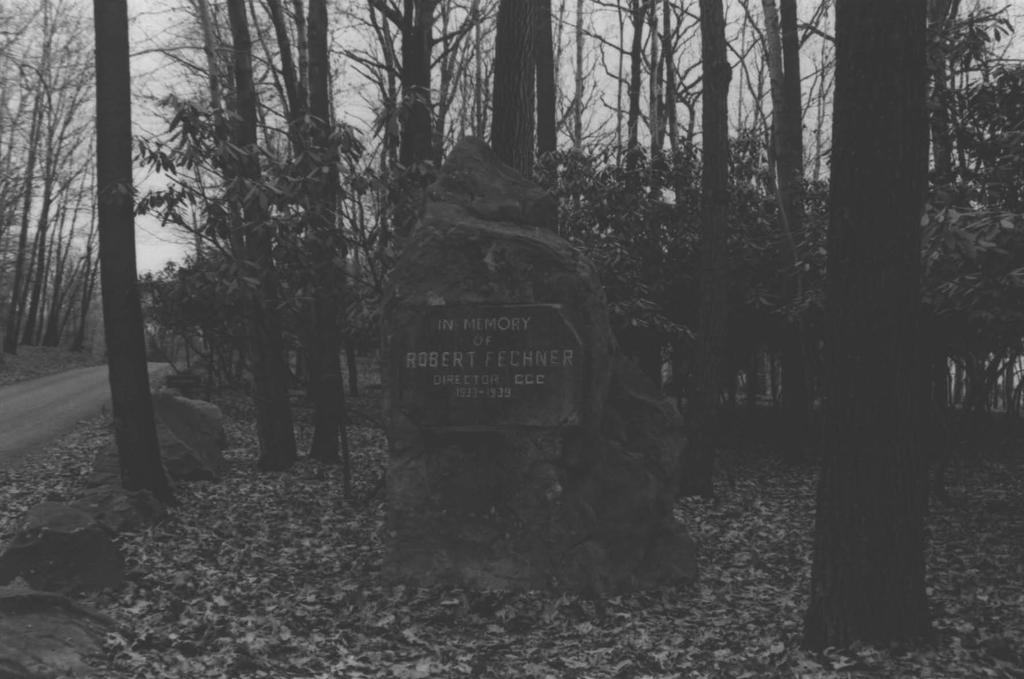
5 NPS Form United States Department of the Interior National Park Service NATIONAL REGISTER OF HISTORIC PLACES CONTINUATION SHEET Section number 7 Page A The Camp Rhododendron Recreational Historic District, located within the Coopers Rock State Forest near Morgantown, Monongalia County, W.V., consists of ten related buildings, structures, and objects clustered within a heavily forested tract above a deep gorge. The nearby gigantic Coopers Rock, the overlook, and the valley present one of West Virginia's most spectacular panoramas. The work of the Civilian Conservation Corps, Camp Rhododendron was constructed between 1936 and Most of the resources within the complex were finished by They are designed in the Rustic architectural style, typical of the Depression - era CCC. Construction involves rough-hewn log and sandstone, load-bearing masonry. The buildings are essentially symmetrical in overall composition and reflect a close relationship with the landscape. Connecting the district's sections, buildings, and structures are stone pathways, low walls, and occasional fences that remain in their original natural settings within old-growth vegetation. Inventory of Contributing and Noncontributing Resources 1. Pumphouse - C. The stone pumphouse is one story high, and made of cut sandstone and wood. There is blacksmithed hardware including latch, hinges, and window bars. The windows are arch shaped with arch shaped wood shutters. The window bars are located underneath the wood shutters. The roof material is asphalt shingles (green color). The wood door has vertical boards and blacksmithed decorative hinges, and latch. The decorative design on the latch & hinges is reminescent of hobnail glass patterns. The pumphouse sits in one of the main picnic areas, approximately 200 feet off, to the right, of the main entrance road. Minimal change has occurred since it was built in the late 1930's. The original wood shake roofing material was replaced with green asphalt shingles during the mid-1970s. 2. Robert Fechner Monument- C. This monument, dedicated to Robert Fechner, is constructed of cut sandstone. The dimensions of the monument are 10 feet high by 6 feet wide. The hand-chiseled words on the front are as follows:
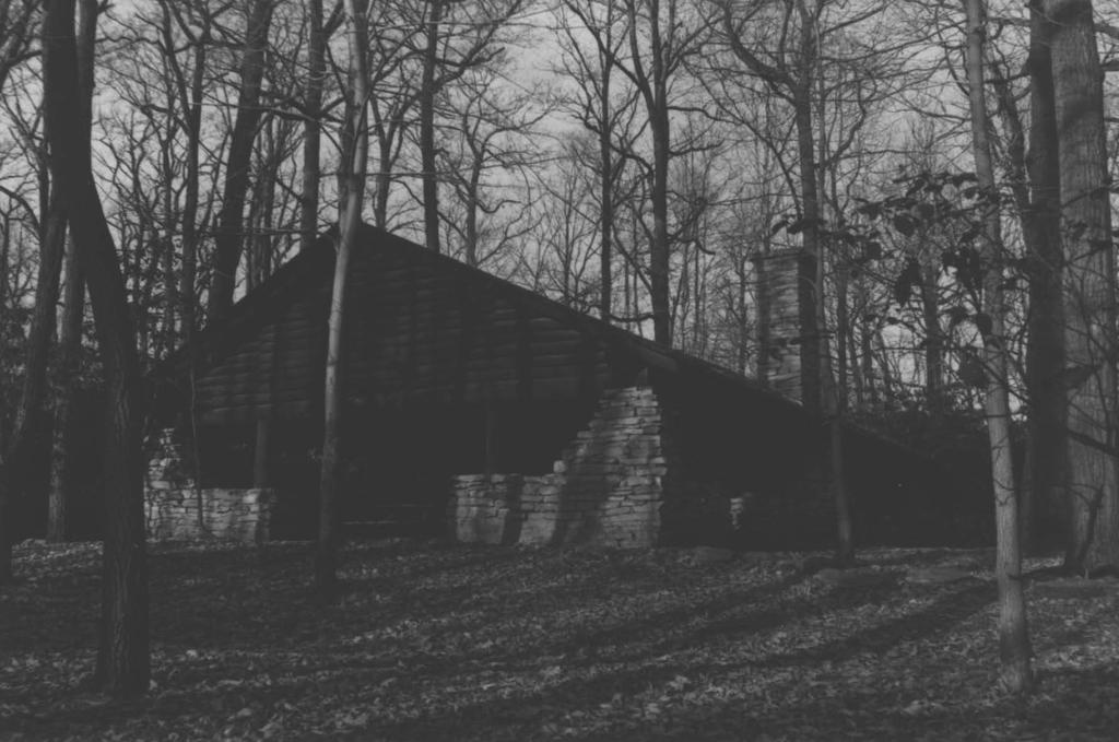
6 NPS Form United States Department of the Interiot National Park Service NATIONAL REGISTER OF HISTORIC PLACES CONTINUATION SHEET Section number 7 Page L IN MEMORY OF ROBERT FECHNER DIRECTOR OF CCC The monument has the appearance of a large rock boulder with an attached sign surface, but is all one piece of sandstone. It displays a massive appearance. The Robert Fechner Monument has not been changed by man, but by nature. The chiseled lettering has lost some of its depth, due to constant exposure to the elements (primarily air pollution). Luckily, the monument has not suffered from vandalism (to date). Information Booth - C. The building is symmetrical in composition; one story high, and is constructed of sandstone, and logs. The logs are used as rafters, and support posts. The structure measures 11 feet wide by 10 feet long, thus it is almost square, but not quite. The rectangular structure is open on the back side, to allow the person manning the booth to walk in and out. The unenclosed structure has a stone counter, and two half log seats on the inside, on the left and right sides. Originally the structure had wood shake roof material, but now has green asphalt shingles. The shingles were added in the mid-1970s. The only change in physical appearance since it was built in the late 1930s, it the absence of two signs. A wood sign with the words "Information Booth" used to hang from the roof on the front side. Additionally, there used to be a small sign that told the hours of operation. The handmade iron hooks for the hours of operation sign are still intact. Pavilion No. 1 - C. Pavilion No. 1 is symmetrical in composition and features three feet high sandstone walls, with log support beams that measure 4 1/2 feet in diameter. The logs appear to be poplar. The sandstone roof support columns, found on all four corners, are massive in appearance. The shed-type roof slopes down dramatically to meet these massive, sandstone support columns.
7 NPS Form United States Department of the Interior National Park Service NATIONAL REGISTER OF HISTORIC PLACES CONTINUATION SHEET Section number 7 Page 3 The low sandstone walls surrounding the perimeter of the structure provide shelter from the elements for the picnic participants, but at the same time open up the beauty of the outdoor environment to the participants inside. The unenclosed design of the structure, personifies the 'one-with-nature' design principles of the Civilian Conservation Corps. The interior of the pavilion features a massive stone fireplace, with a stone mantelpiece. The interior floor surface is constructed of sandstone. The overall dimensions of this structure are: 55' length, and 38' width. The pavilion sits on a site that is occupied by another pavilion directly across from it. The pavilions are joined by a beautiful flagstone walkway that also travels back out to the original parking lot area, and also travels down to the Overlook area. This walkway arrangement gives the feeling of a plaza. The historic appearance of this structure would be little changed from present day appearance. The picnic tables inside the pavilion have been replaced since the 1930s, and the roofing material was changed from wood shake to green asphalt shingle material, during the mid-1970s. Several roof support logs are showing evidence of rotting on the very ends. 5. Pavilion No. 2 - C. Pavilion No. 2 is symmetrical in composition and features three feet high sandstone walls, with log support beams that measure 4 1/2 feet in diameter. The sandstone roof support columns, are massive in appearance. The sandstone support columns are 12' high. This pavilion (No. 2) almost mirrors the pavilion across the plaza from it (Pavilion No. 1). When measuring them both, I found a slight difference in size. Pavilion No. 2 measures 54' long by 39' wide. Thus, these buildings only show approximately one inch difference in size. This second pavilion features a fireplace that is also different than No. 1. The fireplace is made of the same sandstone, but features a log mantelpiece instead of stone. The floor is the same as No.1, and is constructed of sandstone. This structure has the same 'open air' feeling as does No. 1. The unenclosed design truly does bring the outdoors inside.
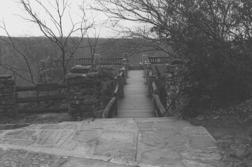
8 NPS Form United States Department of the Interior National Park Service NATIONAL REGISTER OF HISTORIC PLACES CONTINUATION SHEET Section number 7 Page 4 The historic appearance has changed little since the 1930s. The picnic tables have been replaced over the years, and the roof was replaced in the 1970s. Originally the roofing material was wood shake, but the replacement roof is asphalt shingles. Lightning struck this building several years ago, and one log had to be replaced. (According to Superintendent Kerns.) 6. Overlook/Walkway - C. The Overlook/Walkway sits on a foundation of natural sandstone rock formations. The Walkway is constructed of sandstone support pylons, and locust logs. The Walkway railings approach the Walkway from both the North and South directions curving along the sandstone rock formations; then straighten out to form the main body of the Walkway. The steps coursing down to the Walkway are one-half replacement of concrete (top of steps), and one-half original sandstone step (second set that align with the Walkway planking boards) that were shot and drilled. The Walkway planking boards have been replaced recently. (Originally, they were oak planking boards, but now are made with pressure-treated wood boards.) The Walkway is now reinforced with a steel I-beam that was installed by the DNR Forest Department in Originally, there were locust logs used for the main support reinforcement under the Walkway. A combination of increased foot traffic over the years, and deterioration of locust logs, due to weather exposure, necessitated the use of a stronger reinforcement system. (Currently, the C.R.S.F. has a annual visitation rate of approximately 400,000 +.) The Overlook is perched on top of a magnificent ancient sandstone rock formation that looks down on the Cheat River Gorge. The gorge is approximately 1,000 feet below. The overlook Railings are made of locust logs. They are replaced, when needed, with locust logs. The Overlook railings are supported by sandstone pylons (approximately 10' apart). The overlook rock has a small rhododendron shrub growing up through he rock surface. (Evidently, it has been growing for many years, but due to lack of water, thus poor root system it remains very small for its age.) You can view parts of Maryland, West Virginia, and Pennsylvania from the Overlook. The physical appearance has changed little since it was constructed in The hardwood trees and rhododendrons get larger every year. The "graffiti" carved on the Overlook slowly increases from year to year, but luckily seems to be a "fad" that is dying out. Several of the cap stones are missing from the sandstone pylons. Additionally, there are two metal mechanical viewers mounted into the Overlook rock formation. The date of their installation is unknown at this time.
9 NPS Form United States Department of the Interior National Park Service NATIONAL REGISTER OF HISTORIC PLACES CONTINUATION SHEET Section number 7 Page 5 Concession Stand - C. The Concession Stand is symmetrical in composition, one story high, and constructed of logs, and sandstone. This building is shaped in an almost exaggerated T-shape. The front of the building is an open air, almost pavilion like design. This open air front extension now houses two pavilion picnic areas with picnic benches. The back of the building is a one-story, two-room log cabin. Originally, this cabin was used to house a staff member. It is now used for activities connected to the concession business. This building measures 62' wide, and 45' deep. Massive logs create the pavilion areas. These massive log roof supports and rafters are in solid, non-rotted condition. Some of the log railings were removed along the front side, when the 1950s concession counter space was installed. (I imagine this was done to prevent massive traffic jams from occurring when the tourists are buying their hot dogs and souvenirs.) 8. Fire Warninq Siqn - C. The Fire Warning Sign, dedicated to the prevention of forest fires, is constructed of cut sandstone. There are large sandstone pylons that act as a base to the sculpture. The face of the piece is chiseled sandstone. The fire prevention message begins with the line, "Fire is the greatest enemy of the beauty and usefulness of each forest." The last line reads, "You have a share of each state forest, protect it." A warning about careless behavior of campfires is also chiseled on the sculpture. The Fire Warning Sign is 8' wide, and 6' 6" high. (This dimension figure includes the base.) It was carved in (The date is carved on the bottom.) The sculpture has not been changed by man, but by nature. The chiseled lettering is slightly worn, due to weather exposure and air pollution. To date, the piece has not been damaged by vandals. The backside of this piece is interesting. Evidently, the person who carved it made a mistake in his lettering, because the chiseled words were started on the back side.
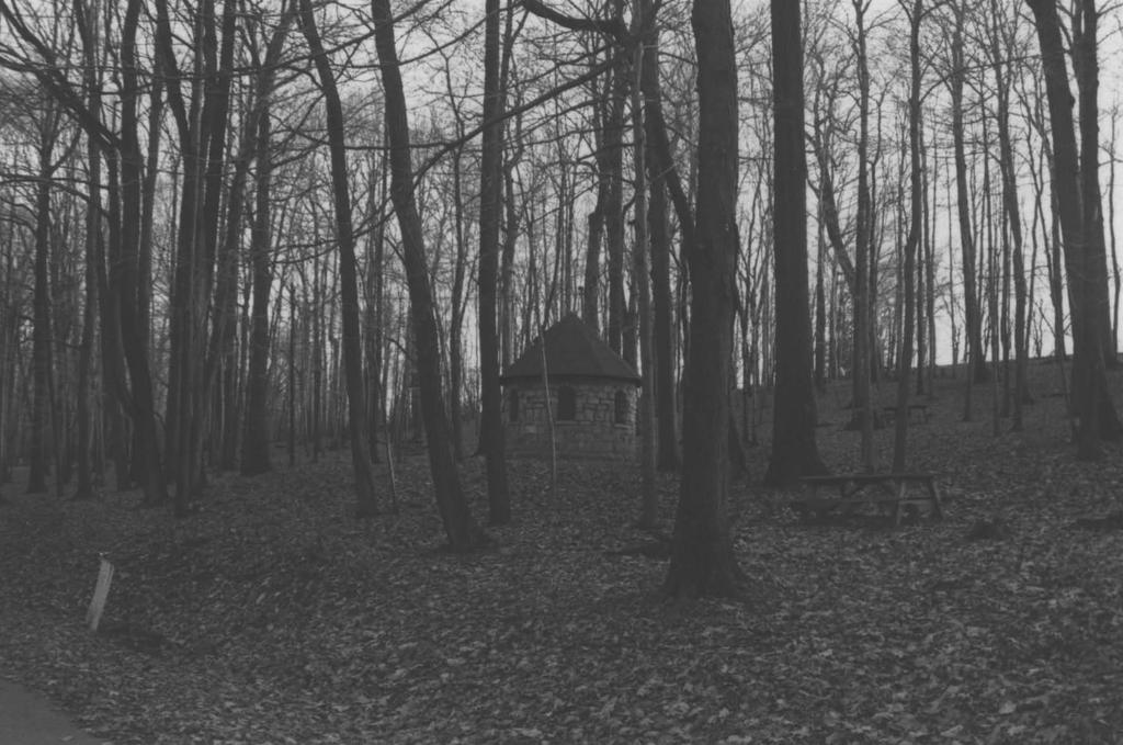
10 NPS Form United States Department of the Interior National Park Service NATIONAL REGISTER OF HISTORIC PLACES CONTINUATION SHEET Section number 7 Page b 9. Pavilion No. 3 - C. Pavilion No. 3 is located in the area of the C.R.S.F. section known as the Rock City Trail area. This area is located to the NW, approximately 3/4 of a mile from the Concession Stand. The Rock City road leading to this area was constructed by Camp Rhododendron. This CCC constructed road bed displays drain, culvert, & retaining walls, which were all constructed of cut sandstone. The Pavilion No. 3 sits uphill from the Rock City Trail Road. This pavilion is smaller than Pavilion No. 1 and 2. It measures approximately 40' in length and 25' 6" in depth. This pavilion has a more enclosed feeling than No. 1 and 2. Three feet high log walls enclose most of the building, although there are three entrances to the structure. The massive, cut stone chimney and fireplace, create the focal point for both the interior and exterior. Stone steps grace both the front and left side of the structure. 10. Trail Trail Chalet - C. Rock City Trail Chalet is located on the Rock City Trail, and is approximately one-half mile from the Pavilion No. 3. You cannot reach this structure by a main road. The trail is made for foot traffic only. (Cross-country skiers also use this trail in the winter time.) This structure reminds one of a chalet. He roof sweeps sharply down in a A-shape. The front of the structure has a large, open doorway. The doorway is flanked on both sides by small rooms, that appear to be for wood storage. The back of the structure is almost butted-up against a rock formation that is covered with old-growth rhododendrons. The back has two window openings, that originally had coverings of some type. (Probably wood frames with wood window covers. ) Rock City Trail Chalet was obviously built for shelter from the elements. But yet it was not totally enclosed; i.e. open air front opening. It has a stone foundation, and log walls. There is a massive stone chimney and fireplace that has been vandalized over the years with graffiti.
11 NPS Form United States Department of the Interior National Park Service NATIONAL REGISTER OF HISTORIC PLACES CONTINUATION SHEET Section number 7 Page 7 NON-CONTRIBUTING RESOURCES Two toilet buildings, recently constructed (see sketch map), are noncontributing resources within the historic district.
12 NPS Form United States Department of the Interior National Park Service NATIONAL REGISTER OF HISTORIC PLACES CONTINUATION SHEET Section number 8 Page I Significance The resources within the Camp Rhododendron Recreational Historic District, constructed by the CCC, represent an integral part of the functioning of the Coopers Rock State Forest park. They were constructed in the Depression-era Rustic style of architecture which reflected a close relationship with the landscape. The period of construction is from about 1936 to The CCC made a lasting impression on the landscape of America. The development of state parks and forests during this time still affect recreation patterns and conservation of America's natural resources. The district's buildings, structures, and objects are significant under National Register Criteria A and C. Criterion A significance is met through association with the Depression-era CCC program. This period in our national, state, and local history affected the economic, social, and conservation patterns in our country. The buildings are significant under Criterion C because they embody the style and qualities that represent CCC's Rustic 'one-with-nature' design. They continue to display integrity of location and setting. During President Franklin D. Roosevelt's first 100 days in office, "New Deal" programs were developed to try and put the country back on its collective feet. The W.P.A. (Works Projects Administration); F.D.I.C. (Federal Deposit Insurance Corporation); N.Y.A. (National Youth Administration); T.V.A. (Tennessee Valley Authority), and CCC (Civilian Conservation Corps) were all created as New Deal agencies. The Civilian Conservation Corps, or CCC, was Roosevelt's personal favorite. It would become his "pet" project over the next nine years. Roosevelt was spiritually a 'man-of-the earth'. He subscribed to the Jeffersonian ideal of man being best when one-with-nature. Roosevelt's personal philosophy coupled with the fact that the U.S. was succumbing to landscape destruction, helped create the CCC. Additionally, Roosevelt was a friend and ardent follower of Gifford Pinchot, who was the first Chief of the U.S. Forest Service. The CCC program seems a logical result of these facts.
13 NPS Form United States Department of the Interior National Park Service NATIONAL REGISTER OF HISTORIC PLACES CONTINUATION SHEET Section number 8 Page A All of the CCC-constructed resources share on-hing in common: rugged design that was known as "Rustic" style architecture. The resources all remain in their original natural settings, and reflect a 'one-with-nature' styling. This nonintrusive style was accomplished by use of natural buildings materials (stone and timber), low silhouette with horizontal lines, and close attention to proportion. Since these facilities were basically crafted by hand with minimal assistance from modern machinery, they share a somewhat crude, handmade, but well crafted appearance. Many landscaping elements were completed during the period as well. These included decorative stone walls; stone retaining walls; stone drainage ditches; stone culverts; stone resevoir; stone fountains; stone fireplaces; stone steps, and stone walkways. These elements are quite significant because they exemplify Rustic architecture by virtue of their complementary and aesthetic placement among natural features of the earth. Further, the setting and buildings were, and remain, attractive to tourists who visited the forest for recreation purposes, including hiking, walking, and picnicking.
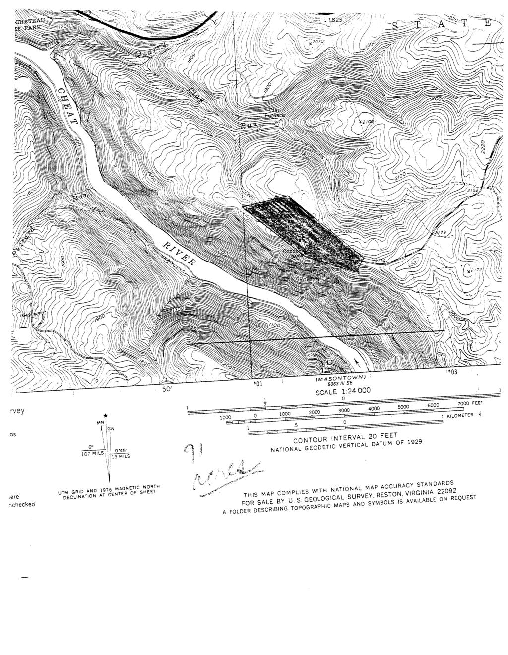
14 NPS Form &7 United States Department of the Interior National Park Service NATIONAL REGISTER OF HISTORIC PLACES CONTINUATION SHEET Section number 10 Page - - I - Verbal Boundary Description The Camp Rhododendron Recreational Historic District is a mile-long complex located at the south end of the Coopers Rock State Forest access road. Its southern and southwestern boundary is formed by the precipice of the Cheat River gorge. Along this cliff line is the forest's most famous sight, the enormous Cooper's Rock, which is an integral part of the nominated district. Beginning at Cooper's Rock the boundary runs 1600 ft. S.E., thence N.E. 600 ft. and crossing the access road, thence beginning 100ft. N.E. of the access road in a straight line running N.W ft., thence in a straight line S.W ft. to the canyon rim, thence in a straight line 2600 ft. S.E. to the point of beginning at Coopers Rock. Boundary Justification The nominated resources comprise a recognizable, cohesive collection of Rustic forest-related architecture within which paved roads, paths, and scenic overlooks provide unifying elements. The nominated resources are clustered in this portion of Coopers Rock State Forest and are not found in other portions of the forest between State Route 48 and Coopers Rock.
15
16
17
18
19
20
aitea Btatas Department of the Interior
 NPS Form 10-900.. OMB No. 1024-0018 (Rev. 8-86) aitea Btatas Department of the Interior.+ational Park Service NATIONAL REGISTER OF HISTORIC PLACES REGISTRATION FORH --------... - ------ -------------...
1. Name of Property historic name Lake Bemidli State Park CCC/NY A/Rustic Style Historic Resources other names/site number Lake Bemidli State Park
 I NFS Form 10-900 (Rev. (WW) United States Department of the Interior National Park Service National Register of Historic Places Registration Form ltt
NPS Form OMB No (Oct. 1990)
") NPS Form 10-900 OMB No. 10024-0018 (Oct. 1990) United States Department of the Interior National Park Service NATIONAL REGISTER OF HISTORIC PLACES REGISTRATION FORM 1. historic name: other name/site number:
NPS Form 10-900 OMB No. 10024-0018 (Oct. 1990) United States Department of the Interior National Park Service NATIONAL REGISTER OF HISTORIC PLACES REGISTRATION FORM 1. historic name: other name/site number:
historic name: STARR MILL ROAD BRIDGE other name/site number: Beverly Heights Bridge. Bridge No. 4541
 NFS Form 10-900 < (Rev. 8-86)! REGISTRATION FORM RECEIVED OCT 2 8 1993 NATIONAL REGISTER *! 0 2 4 0 0 1 8 =============================================$======================= === 1. Name of Property '
- buildings. (Rev. 8-86) NATIONAL REGISTER OF HISTORIC PLACES REGISTRATION FORM. other name/site number: not for publication:
 NATIONAL REGISTER OF HISTORIC PLACES REGISTRATION FORM. other name/site number: not for publication:") NPS Form 10-900 (Rev. 8-86) OMB No. 1024-0018 f United States Department of the Interior National Park Service NATIONAL REGISTER OF HISTORIC PLACES REGISTRATION FORM other name/site number: not for publication:
NPS Form 10-900 (Rev. 8-86) OMB No. 1024-0018 f United States Department of the Interior National Park Service NATIONAL REGISTER OF HISTORIC PLACES REGISTRATION FORM other name/site number: not for publication:
- As the designated authority under the National Historic Preservation Act
 - As the designated authority under the National Historic Preservation Act of 1986, as amended, I hereby certify that this )C nomination - request for determination of eligibility meets the documentation
Maryland Historical Trust Inventory No. PG: 85B-007 Maryland Inventory of Historic Properties Form
 Maryland Historical Trust Inventory No. PG: 85B-007 Maryland Inventory of 1. Name of Property (indicate preferred name) historic other 2. Location street and number Cedarville State Forest Road, Cedarville
m2s,p!=s 1. Name of Property Number of Resources within Property: NATIONAL REGXSTER OF HISTORIC PLACES
 i. NPS Foxm 10-900 (Rev. 8-86) Ynited States Department of the Interior Iational Park Service NATIONAL REGXSTER OF HISTORIC PLACES REGfSTBATION FORM... m2s,p!=s 1. Name of Property... ----------- --------------+-------------------------------------------
Architectural Inventory Form
 COLORADO CULTURAL RESOURCE SURVEY Page 1 of 8 Official Eligibility Determination (OAHP use only) Rev. 9/98 OAHP1403 Date Initials Determined Eligible National Register Determined Not Eligible National
National Register of Historic Places Continuation Sheet
 NM Form 104004 OKU Appmtl No, Section number Page SUPPLEMENTARY LISTING RECORD NRIS Reference Number: 89001847 Date Listed: 11/6/89 Queens Avenue Bridge Hennepin MN Property Name County State Reinforced-Concrete
buildings sites structures objects 0 Total Number of contributing resources previously listed in the National Register : 0
 NPS Form 10-900 (Rev. 8-86) OMB No. 1024-0018 United States Department of the Interior National Park Service NATIONAL REGISTER OF HISTORIC PLACES REGISTRATION FORM other name/site number: 2. Location street
N~ l)s'f1jd l2/ l?~ I qjt OMB No
s'f1jd l2/ l?~ I qjt OMB No") NPS Form 10-900 (Rev. 8-86) N~ l)s'f1jd l2/ l?~ I qjt OMB No. 1024-0018 United States Department of the Interior National Park Service NATIONAL REGISTER OF HISTORIC PLACES REGISTRATION FORM 1. Name of
NPS Form 10-900 (Rev. 8-86) N~ l)s'f1jd l2/ l?~ I qjt OMB No. 1024-0018 United States Department of the Interior National Park Service NATIONAL REGISTER OF HISTORIC PLACES REGISTRATION FORM 1. Name of
Lincoln Mill and Mill Village Historic District. National Register Nomination. 25 May 2009 SCHNEIDER. Historic Preservation, LLC
 Lincoln Mill and Mill Village Historic District National Register Nomination 25 May 2009 SCHNEIDER Historic Preservation, LLC 411 E. 6th Street, Anniston, Alabama 36207 Phone: 256-310-6320 e-mail: dbschneider@bellsouth.net
Architectural Inventory Form (page 1 of 5)
") OAHP1403 Rev. 9/98 COLORADO CULTURAL RESOURCE SURVEY (page 1 of 5) I. IDENTIFICATION 1. Resource number 5RT-2050 2. Temporary resource number: 145008005 3. County: Routt County 4. City: Steamboat Springs
OAHP1403 Rev. 9/98 COLORADO CULTURAL RESOURCE SURVEY (page 1 of 5) I. IDENTIFICATION 1. Resource number 5RT-2050 2. Temporary resource number: 145008005 3. County: Routt County 4. City: Steamboat Springs
ARLINGTON COUNTY REGISTER OF HISTORIC PLACES HISTORIC DISTRICT DESIGNATION FORM
 ARLINGTON COUNTY REGISTER OF HISTORIC PLACES HISTORIC DISTRICT DESIGNATION FORM 1. NAME OF PROPERTY Historic Name: Other names: Dawson House Rio Vista, Dawson Bailey House 2. LOCATION OF PROPERTY Street
MINNESOTA ARCHITECTURE - HISTORY INVENTORY FORM
 Historic Name Identification Chimney Rock Footbridge SHPO Inventory Number Review and Compliance Number Current Name Chimney Rock Footbridge Field # Address Ped. Bridge Over Whitewater River in Whitewater
NOT FOR PUBLICATION: N/A VICINITY: N/A STATE:Texas CODE: TX COUNTY: Bexar CODE: 029 ZIP CODE: 78205
 (Oct. 1990) United States Department of the Interior National Park Service NATIONAL REGISTER OF HISTORIC PLACES REGISTRATION FORM 1. NAME OF PROPERTY HISTORIC NAME: Chinese Sunken Garden Gate OTHER NAME/SITE
Architectural Inventory Form
 OAHP1403 Rev. 9/98 COLORADO CULTURAL RESOURCE SURVEY Architectural Inventory Form Official eligibility determination (OAHP use only) Date Initials Determined Eligible- NR Determined Not Eligible- NR Determined
=-=========================================================================
 NPS Form 10-900 (Rev. 8-86) United States Department of the Interior N~tional Park Service IONAL REGISTER OF HISTORIC PLACES REGISTRATION FORM [\ l r~ LISTED JUr J O 3 1998,,.,-)p fu d OMB No. 1024-0028
Architectural Inventory Form
 OAHP1403 Rev. 9/98 COLORADO CULTURAL RESOURCE SURVEY Architectural Inventory Form Official eligibility determination (OAHP use only) Date Initials Determined Eligible- NR Determined Not Eligible- NR Determined
Section IV. Impacts to Cultural Resources
 Section IV Impacts to Cultural Resources 83 Archaeological Sites and Traditional Cultural Properties. Specific resources were not identified in this edition of the Mount Spokane CRMP, and as a result no
X vicinity of. 22 county. Status X occupied unoccupied work in progress Accessible yes: restricted yes: unrestricted no. 515 Second Street SW
 FHR-8-300 (11-78) United States Department of the nterior Heritage Conservation and Recreation Service National Register of Historic Places nventory Nomination Form See instructions in How to Complete
V141S90' NATIONAL REGISTER. NPS Form (Rev. 8-86) OMB No
 OMB No") NPS Form 10-900 (Rev. 8-86) United States Departaent of tha Interior National Park Service NATIONAL REGISTER OF HISTORIC PLACES REGISTRATION FORM OMB No. 1024-0018 V141S90' NATIONAL REGISTER 1. Name of
NPS Form 10-900 (Rev. 8-86) United States Departaent of tha Interior National Park Service NATIONAL REGISTER OF HISTORIC PLACES REGISTRATION FORM OMB No. 1024-0018 V141S90' NATIONAL REGISTER 1. Name of
North River Mills Bridge Hampshire County State Project # S314-45/ Federal Project # ARRA-4520(003)D FR#: HM-1
D FR#: HM-1") North River Mills Bridge Hampshire County State Project # S314-45/20-2.40 02 Federal Project # ARRA-4520(003)D FR#: 10-1463-HM-1 STATE LEVEL OF HISTORIC DOCUMENTATION November 2010 West Virginia Department
North River Mills Bridge Hampshire County State Project # S314-45/20-2.40 02 Federal Project # ARRA-4520(003)D FR#: 10-1463-HM-1 STATE LEVEL OF HISTORIC DOCUMENTATION November 2010 West Virginia Department
Architectural Inventory Form
 COLORADO CULTURAL RESOURCE SURVEY Page 1 of 8 Official Eligibility Determination (OAHP use only) Rev. 9/98 OAHP1403 Date Initials Determined Eligible National Register Determined Not Eligible National
OMB v*m? No
 NPS Form 10-900 (Rev. 10-90) OMB v*m? No. 1024-001 United States Department of the Interior National Park Service NATIONAL REGISTER OF HISTORIC PLACES REGISTRATION FORW - -- - -- - 1. STOUTS MILL BRIDGE
Historic Property Report
 Historic Name: Rutter Parkway Stone Structures Property ID: 706402 Location Address: GeographicAreas: W Rutter Pkwy, Spokane, Washington, USA Spokane,Spokane County,T26R42E03,DARTFORD Quadrangle Information
HISTORIC SITE FORM - HISTORIC SITES INVENTORY PARK CITY MUNICIPAL CORPORATION (10-08) 1 IDENTIFICATION
 1 IDENTIFICATION") HISTORIC SITE FORM - HISTORIC SITES INVENTORY PARK CITY MUNICIPAL CORPORATION (10-08) 1 IDENTIFICATION Name of Property: Address: 164 Sandridge Road AKA: City, County: Park City, Summit County, Utah Tax
HISTORIC SITE FORM - HISTORIC SITES INVENTORY PARK CITY MUNICIPAL CORPORATION (10-08) 1 IDENTIFICATION Name of Property: Address: 164 Sandridge Road AKA: City, County: Park City, Summit County, Utah Tax
National Register of Historic Places Registration Form
 NPS Fom 10-9Oo (Rw. 1O'9O) United States Department of the Interior Registration Form ThisJormistoruseinnominatingorrequestingdeterminationsforindividUa Propertiesanddistricts.Sesinst'uctionsinHowtocomPletetheNationa
National Register of Historic Places Continuation Sheet
 NPS Form 10-900-a OMB Approval No. 1024-OO18 National Register of Historic Places Continuation Sheet Section number Page SUPPLEMENTARY LISTING RECORD NRIS Reference Number: 98000686 Date Listed: 6/29/98
MINNESOTA ARCHITECTURE - HISTORY INVENTORY FORM
 Identification Historic Name Bridge L8849 Current Name Bridge L8849 Field # Address Municipal Road 99 over the Chippewa River City/Twp Montevideo County Chippewa Legal Desc. Twp 117N Range 40W Sec 07 QQ
Architectural Inventory Form (page 1 of 5)
") OAHP1403 Rev. 9/98 COLORADO CULTURAL RESOURCE SURVEY (page 1 of 5) Official eligibility determination (OAHP use only) Date Initials Determined Eligible- NR Determined Not Eligible- NR Determined Eligible-
OAHP1403 Rev. 9/98 COLORADO CULTURAL RESOURCE SURVEY (page 1 of 5) Official eligibility determination (OAHP use only) Date Initials Determined Eligible- NR Determined Not Eligible- NR Determined Eligible-
Architectural Inventory Form
 IMPORTANT NOTICE OAHP1403 Rev. 9/98 COLORADO CULTURAL RESOURCE SURVEY Page 1 This survey form represents a only. All information, particularly determinations of eligibility for the National Register, the
IMPORTANT NOTICE. Architectural Inventory Form COLORADO CULTURAL RESOURCE SURVEY I. IDENTIFICATION th Street 5WL.5601
 IMPORTANT NOTICE OAHP1403 Rev. 9/98 COLORADO CULTURAL RESOURCE SURVEY Architectural Inventory Form Page 1 This survey form represents an UNOFFICIAL COPY and is provided for informational purposes only.
Maryland Historical Trust Inventory No. PG: 71A-006 Maryland Inventory of Historic Properties Form
 Inventory No. PG: 71A-006 Maryland Inventory of 1. Name of Property (indicate preferred name) historic other 2. Location Concrete Railroad Bridge Washington, Baltimore, & Annapolis Electric Railway Bridge
National Register of Historic Places Inventory Nomination Form
 NPS Form 10.900-a OMB No. 1024-0018 (3.82) Exp. 10-31-84 United States Department of the Interior National Park Service National Register of Historic Places Inventory Nomination Form received date entered
THE CITY OF LAKE FOREST HISTORIC PRESERVATION COMMISSION LOCAL LANDMARK NOMINATION INSTRUCTIONS
 THE CITY OF LAKE FOREST HISTORIC PRESERVATION COMMISSION LOCAL LANDMARK NOMINATION INSTRUCTIONS This application is for the nomination of individual properties as Local Historic Landmarks within the City
Eligible, see Statement of Significance. Roadside Development on Minnesota Trunk Highways,
 Historic Name CS # 0115 Other Name SHPO Inv # Location Both sides of TH 169 on isthmus between Little Pine Lake and Hickory Lake Hwy District Reference City/Township County Farm Island Township Aitkin
National Register of Historic Places Continuation Sheet
 NPS Form 10-900-a (Rev. 8/2002) OMB No. 1024-0018 (Expires 5-31-2012) United States Department of the Interior National Park Service National Register of Historic Places Continuation Sheet Bridge No. 5721
FORT MISSOULA REGIONAL PARK
 FORT MISSOULA REGIONAL PARK Master Plan Refinement/ Design Development www.missoulaparks.org DHM Design/WGM Group December 3, 2008 Master Plan Report Fort Missoula Regional Park Guiding Principals i 6/14/01
Dr. Jeff Pappas, New Mexico States Historic Preservation Officer. Signature of certifying official/title:
 United States Department of the Interior National Park Service National Register of Historic Places Registration Form This form is for use in nominating or requesting determinations for individual properties
Architectural Inventory Form
 COLORADO CULTURAL RESOURCE SURVEY Page 1 of 8 Official Eligibility Determination (OAHP use only) Rev. 9/98 OAHP1403 Date Initials Determined Eligible National Register Determined Not Eligible National
CITY OF MIAMI CEMETERY 1800 N.E. 2 AVENUE
 CITY OF MIAMI CEMETERY 1800 N.E. 2 AVENUE Designation Report City of Miami REPORT OF THE CITY OF MIAMI PLANNING DEPARTMENT TO THE HERITAGE CONSERVATION BOARD ON THE POTENTIAL DESIGNATION OF CITY OF MIAMI
12 Foot Davis and Adjacent Sites
 Peace River, Alberta Proposed Concept Design Presentation and Discussion January 26, 2010 Peace River Provincial Recreation Area 12 Foot Davis Grave Site Dr. Greene Cairn North Environments Landscape Architects
HISTORIC SITE FORM - HISTORIC SITES INVENTORY PARK CITY MUNICIPAL CORPORATION (10-08) 1 IDENTIFICATION
 1 IDENTIFICATION") HISTORIC SITE FORM - HISTORIC SITES INVENTORY PARK CITY MUNICIPAL CORPORATION (10-08) 1 IDENTIFICATION Name of Property: Address: 158 Main Street City, County: Park City, Summit County, Utah AKA: Tax Number:
HISTORIC SITE FORM - HISTORIC SITES INVENTORY PARK CITY MUNICIPAL CORPORATION (10-08) 1 IDENTIFICATION Name of Property: Address: 158 Main Street City, County: Park City, Summit County, Utah AKA: Tax Number:
NATIONAL REGISTER OF HISTORIC PLACES MULTIPLE PROPERTY DOCUMENTATION FORM CONTINUATION SHEET ASSOCIATED PROPERTY TYPES
 Section F, Page 1 ASSOCIATED PROPERTY TYPES Six common property types are identified with the 48 cemeteries surveyed in the Town of Southampton. These six property types are identified as being associated
Chapter 4: Jordan Road Character District
 4: Jordan Road Character District 4.1 Introduction The Jordan Road character district encompasses much of the former Jordan orchard and farmstead, which was a significant part of Sedona s history. The
Town Center Design Guidelines
 Adopted by City Council on September 18, 2018 Design Theme The Draper Town Center Design Theme is defined as encompassing those architectural design styles that were prevalent in the construction of civic
Nature s inspiration truly makes it home. The unique textures,
 Gracious Style Natural Appeal Limestone Chisel Gray Ledgestone Sienna Fieldstone Allegheny Nature s inspiration truly makes it home. The unique textures, subtle hues and unforgettable character found
City of Fort Lupton Administrative Site Plan Process
 City of Fort Lupton Administrative Site Plan Process Purpose The Site Plan process is meant to promote orderly and sound development standards as they apply to the City. These site development standards
National Register of Historic Places inventory Nomination Form
 NPS Form 10-900-a OMB No. 1024-0018 (3-82) Exp. 10-31-84 United States Department of the Interior National Park Service National Register of Historic Places inventory Nomination Form F
Architectural Inventory Form
 COLORADO CULTURAL RESOURCE SURVEY Page 1 of 7 Official Eligibility Determination (OAHP use only) Rev. 9/98 OAHP1403 Date Initials Determined Eligible National Register Determined Not Eligible National
Town of Portola Valley General Plan. Nathhorst Triangle Area Plan
 Town of Portola Valley General Plan Amended December 10, 1997 Table of Contents Introduction... 1 Planning Area... 1 Objectives... 2 Principles... 2 Standards... 4 Description... 4 Community Commercial...
PROJECT ASSIGNMENT: DESIGNING AND DRAWING A PLANTATION
 NAME: DATE: PERIOD: D irections This assignment asks you to design and draw a southern plantation on a piece of poster board. This project will allow me to see that you understand how the plantation system
Comment NATURAL ELEMENTS & PLANTINGS
 Park at Gables N. Rolfe Public Meeting, 4/09/14 Public Comments by Topic Location of Comment Comment NATURAL ELEMENTS & PLANTINGS #1 [Like] The preservation of nature [Like] The large amount of green [Like]
Appendix 1: Site Inventory Form
 Appendix 1: Site Inventory Form Wapsi Valley Archaeology, Inc. Anamosa, IA 56 X Cemetery Washington 83 24 2 NE X 1 5 approx. 200 approx. 201 unknown unknown Historic Resources Evaluation: 07A: Cemetery
HISTORIC SITE FORM - HISTORIC SITES INVENTORY PARK CITY MUNICIPAL CORPORATION (10-08) 1 IDENTIFICATION
 1 IDENTIFICATION") HISTORIC SITE FORM - HISTORIC SITES INVENTORY PARK CITY MUNICIPAL CORPORATION (10-08) 1 IDENTIFICATION Name of Property: William Tretheway House Address: 335 Woodside Avenue AKA: City, County: Park City,
HISTORIC SITE FORM - HISTORIC SITES INVENTORY PARK CITY MUNICIPAL CORPORATION (10-08) 1 IDENTIFICATION Name of Property: William Tretheway House Address: 335 Woodside Avenue AKA: City, County: Park City,
Daniels Park Master Plan
 Daniels Park Master Plan Prepared for: Douglas County & The City and County of Denver October, 2007 EXHIBIT A Contents Daniels Park Overview 2 Project History & Goals 2-3 Regional Context Map 4 Park Zone
Burrus Old Mill Park
 Burrus Old Mill Park Park Location: 112 NW Woods Chapel Rd. Park Land Established: 1969 Park Size: 14 acres Developed Acres: 14 acres Undeveloped Acres: 0 acres Park Type: Neighborhood Park Amenities:
A detailed Access Guide to The Iron Bridge & Tollhouse
 A detailed Access Guide to The Iron Bridge & Tollhouse This Guide contains an overview of Access for: Visitors with physical and sensory disabilities Assistance Dogs are welcome at all Museum sites. www.ironbridge.org.uk
South Carolina Historic Landscape Initiative Survey Form
 Survey Name 10-10 South Carolina Historic Landscape Initiative Survey Form 1. Name of garden/historic site 2. Location Street & Number City or Town Zip Code County Garden Club District 3. Geographical
Architectural Inventory Form
 COLORADO CULTURAL RESOURCE SURVEY Page 1 of 3 Official Eligibility Determination (OAHP use only) Rev. 9/98 OAHP1403 Date Initials Determined Eligible National Register Determined Not Eligible National
HISTORIC SITE FORM - HISTORIC SITES INVENTORY PARK CITY MUNICIPAL CORPORATION (10-08) 1 IDENTIFICATION
 1 IDENTIFICATION") HISTORIC SITE FORM - HISTORIC SITES INVENTORY PARK CITY MUNICIPAL CORPORATION (10-08) 1 IDENTIFICATION Name of Property: Lapage H. Raddon House Address: 817 Woodside Avenue AKA: City, County: Park City,
HISTORIC SITE FORM - HISTORIC SITES INVENTORY PARK CITY MUNICIPAL CORPORATION (10-08) 1 IDENTIFICATION Name of Property: Lapage H. Raddon House Address: 817 Woodside Avenue AKA: City, County: Park City,
Twain Harte Meadows Park Design Workshop #2
 Twain Harte Meadows Park Design Workshop #2 Description of Conceptual Design Schemes Important Notes Design Schemes are Conceptual The purpose of these design schemes is to take a step closer to the general,
Chapter 5: Mixed Use Neighborhood Character District
 5: Mixed Use Neighborhood Character District 5.1 Introduction The Mixed Use Neighborhood character district acts as a transition or bridge between the State Route 89A District s commercial area to the
Ottawa Historic Resources Inventory: Commercial Historic District Building Information. Significance and Potential Eligibility
 C 01 1 Address: address 1 PIN: 21 11 218 001 Plan: Rectangular Stories: 2 Original Owner: Roof Type: Flat Building Names: Marquette School Foundation: Important Dates: ca 1955 Walls: BRICK Architect /
DESIGN AND LANDSCAPE GUIDELINES FOR DEVELOPMENT
 DESIGN AND LANDSCAPE GUIDELINES FOR DEVELOPMENT IN THE SECOND SUPERVISORIAL DISTRICT (REVISED) ADOPTED BY RIVERSIDE COUNTY BOARD OF SUPERVISORS ON SEPTEMBER 15, 1998 REVISED OCTOBER 23, 1998 REVISED AUGUST
HISTORIC CONTEXT. Places, William Bushong, Rock Creek Park, Historic Resource Study, National Park Service, 1990.
 HISTORIC CONTEXT The review of Kensington Cabin benefits from an understanding of several interrelated historic themes: suburban development, outdoor recreation, City Beautiful movement, stream valley
HISTORIC SITE FORM - HISTORIC SITES INVENTORY PARK CITY MUNICIPAL CORPORATION (10-08) 1 IDENTIFICATION
 1 IDENTIFICATION") HISTORIC SITE FORM - HISTORIC SITES INVENTORY PARK CITY MUNICIPAL CORPORATION (10-08) 1 IDENTIFICATION Name of Property: McPolin Farmstead Address: 3000 Highway 224 City, County: Park City, Summit County,
HISTORIC SITE FORM - HISTORIC SITES INVENTORY PARK CITY MUNICIPAL CORPORATION (10-08) 1 IDENTIFICATION Name of Property: McPolin Farmstead Address: 3000 Highway 224 City, County: Park City, Summit County,
IMPORTANT NOTICE. Architectural Inventory Form COLORADO CULTURAL RESOURCE SURVEY I. IDENTIFICATION. 655 Bryan Avenue 5BL.10460
 IMPORTANT NOTICE OAHP1403 Rev. 9/98 COLORADO CULTURAL RESOURCE SURVEY Architectural Inventory Form Page 1 This survey form represents an UNOFFICIAL COPY and is provided for informational purposes only.
HISTORIC SITE FORM - HISTORIC SITES INVENTORY PARK CITY MUNICIPAL CORPORATION (10-08) 1 IDENTIFICATION
 1 IDENTIFICATION") HISTORIC SITE FORM - HISTORIC SITES INVENTORY PARK CITY MUNICIPAL CORPORATION (10-08) 1 IDENTIFICATION Name of Property: Marsac Elementary School Address: 445 MARSAC AVE AKA: 431 Marsac Avenue City, County:
HISTORIC SITE FORM - HISTORIC SITES INVENTORY PARK CITY MUNICIPAL CORPORATION (10-08) 1 IDENTIFICATION Name of Property: Marsac Elementary School Address: 445 MARSAC AVE AKA: 431 Marsac Avenue City, County:
Architectural Inventory Form
 IMPORTANT NOTICE OAHP1403 Rev. 9/98 COLORADO CULTURAL RESOURCE SURVEY Page 1 This survey form represents a only. All information, particularly determinations of eligibility for the National Register, the
Neo-Traditional Overlay Application
 MAYOR AND CITY COUNCIL OF LAUREL DEPARTMENT OF ECONOMIC AND COMMUNITY DEVELOPMENT 8103 Sandy Spring Road Laurel, Maryland 20707 (301) 725-5300 Internet Address http://www.cityoflaurel.org E-mail: ecd@laurel.md.us
ARTICLE IV: DEVELOPMENT STANDARDS 404 MASTER PLANNING
 IV 13 404 MASTER PLANNING Master Planning through the Site Analysis (Master Planning Site Analysis) or Planned Development (Master Planning Planned Development) is provided to encourage development which
I. VISUAL/AESTHETICS/NEIGHBORHOOD CHARACTER. b. Existing Conditions Views from Kimball Avenue
 I. VISUAL/AESTHETICS/NEIGHBORHOOD CHARACTER 1. Existing Conditions a. View Of The Site From Area Roads Figures IV.I-2, I-3 and I-4 depict existing views from the Cross County Parkway, Central Park Avenue,
Blue Springs Park. Park Land Established: Developed Acres: 12 acres Undeveloped Acres: 2 acres
 Blue Springs Park Park Location: 2204 SW South Ave. Park Land Established: 1975 Park Size: 14 acres Developed Acres: 12 acres Undeveloped Acres: 2 acres Park Type: Neighborhood Park Amenities: Softball
Attachment 1 December 4, 2012
 Attachment 1 December 4, 2012 RESOLUTION NO. 12 A RESOLUTION OF THE CULTURAL HERITAGE COMMISSION OF THE CITY OF BEVERLY HILLS RECOMMEND[NG THE CITY COUNCIL DESIGNATE THE LILIORE PALMER RAINS ESTATE AT
Number of contributing resources previously Historic and Architectural Resources of listed in the National Register 0
 NPS Fo-m -.C-OOO [P»v. 6-66) United States Department of the interior National Park Sen/ice National Register of Historic Places Registration Form FEB 1 6 K'AT/0,VAL RHG/STER OMBNa 1O24-O01S This form
1. Name of Property. historic name Lowe Building. other names/site number Iowa State Extension Office (current) 2. Location
 2. Location") Site Inventory Form State Inventory No. 61-03173 New Supplemental State Historical Society of Iowa Part of a district with known boundaries (enter inventory no.) 61-00001 (November 2005) Relationship:
Site Inventory Form State Inventory No. 61-03173 New Supplemental State Historical Society of Iowa Part of a district with known boundaries (enter inventory no.) 61-00001 (November 2005) Relationship:
LEGEND. vehicular circulation. pedestrian circulation. bus stop. residential use. civic use. residential/mixed use. commercial use.
 LEGEND vehicular circulation pedestrian circulation bus stop residential use civic use residential/mixed use commercial use on-street parking CIRCULATION ANALYSIS LEGEND enclosed focal point view open
General Manager, Planning and Development; General Manager, Parks, Recreation and Culture. Proposed Mini-Park and Plaza Designations
 Corporate NO: R106 Report COUNCIL DATE: June 16, 2008 REGULAR COUNCIL TO: Mayor & Council DATE: June 12, 2008 FROM: SUBJECT: General Manager, Planning and Development; General Manager, Parks, Recreation
National Register of Historic Places Inventory Nomination Form
 NPS Form 10-900-a {3-82) United States Department of the Interior National Park Service National Register of Historic Places Inventory Nomination Form Continuation sheet Item numtjer all For NPS « mit
KASPER. City of Georgetown, Texas PUD Planned Unit Development. December 30, 2015 Revised January 27, 2016
 KASPER City of Georgetown, Texas PUD Planned Unit Development December 30, 2015 Revised January 27, 2016 Applicant: Sentinel Land Company, LLC 4910 Campus Drive Newport Beach, CA Prepared by: SEC Planning
1999 Approval to replace World War I monument and relocate plaques Approval to rehabilitate the Chase Mill building and surrounding site
 Memorandum PLANNING DIVISION DEPARTMENT OF COMMUNITY AND NEIGHBORHOODS To: Historic Landmark Commission From: Katia Pace, Principal Planner Date: October 26, 2016 Re: Liberty Park Improvements The purpose
CHAPTER FIVE COMMUNITY DESIGN
 CHAPTER FIVE COMMUNITY DESIGN CHAPTER FIVE - COMMUNITY DESIGN Assumptions Frazier Park and Lebec have historically developed according to different patterns of spatial form. While both communities are
National Register of Historic Places Registration Form
 United States Department of the Interior National Park Service National Register of Historic Places Registration Form This form is for use in nominating or requesting determinations for individual properties
CCI Concerned Citizens Group, Inc. Report on Community Survey Regarding Future Use of CCI Property after Cleanup July 1, 2005
 CCI Concerned Citizens Group, Inc. Report on Community Survey Regarding Future Use of CCI Property after Cleanup July 1, 2005 Introduction CCI is a 1.5 acre Superfund site at 320 South Blake Street, Olathe,
FIRST COCONUT GROVE SCHOOLHOUSE
 FIRST COCONUT GROVE SCHOOLHOUSE 3429 DEVON ROAD Designation Report City of Miami REPORT OF THE CITY OF MIAMI PLANNING DEPARTMENT TO THE HERITAGE CONSERVATION BOARD ON THE POTENTIAL DESIGNATION OF THE FIRST
CITY PLANNING COMMISSION AGENDA ITEMS: C.1, C.2 STAFF: MEGGAN HERINGTON FILE NO(S): CPC PUZ QUASI-JUDICIAL CPC PUD QUASI-JUDICIAL
: CPC PUZ QUASI-JUDICIAL CPC PUD QUASI-JUDICIAL") Page 32 CITY PLANNING COMMISSION AGENDA ITEMS: C.1, C.2 STAFF: MEGGAN HERINGTON FILE NO(S): CPC PUZ 13-00036 QUASI-JUDICIAL CPC PUD 13-00037 QUASI-JUDICIAL PROJECT: APPLICANT: OWNER: ESTANCIA AT CORDERA
Page 32 CITY PLANNING COMMISSION AGENDA ITEMS: C.1, C.2 STAFF: MEGGAN HERINGTON FILE NO(S): CPC PUZ 13-00036 QUASI-JUDICIAL CPC PUD 13-00037 QUASI-JUDICIAL PROJECT: APPLICANT: OWNER: ESTANCIA AT CORDERA
PARTF Scoring System for Grants
 PARTF Scoring System for Grants The members of the N.C. Parks and Recreation Authority use the PARTF scoring system as one of several tools to select grant recipients. Please provide all of the information
Arlington, Virginia is a worldclass
 EXECUTIVE S U M M A RY Arlington maintains a rich variety of stable neighborhoods, quality schools and enlightened land use policies, and received the Environmental Protection Agency s highest award for
Architectural Control Committee Promulgated Rules
 Architectural Control Committee Promulgated Rules These promulgated rules are in support of existing items in the governing documents within the Christie Ranch Declaration of Covenants, Conditions, and
FEATHER RIVER RECREATION & PARK DISTRICT MEMORIAL GUIDELINES & APPLICATION
 FEATHER RIVER RECREATION & PARK DISTRICT MEMORIAL GUIDELINES & APPLICATION While appropriate memorials may enrich a park experience for park users, public open space is also a very precious commodity,
HISTORIC SITE FORM - HISTORIC SITES INVENTORY PARK CITY MUNICIPAL CORPORATION (10-08) 1 IDENTIFICATION
 1 IDENTIFICATION") HISTORIC SITE FORM - HISTORIC SITES INVENTORY PARK CITY MUNICIPAL CORPORATION (10-08) 1 IDENTIFICATION Name of Property: John W. Buck House Address: 1110 Woodside Avenue AKA: City, County: Park City, Summit
HISTORIC SITE FORM - HISTORIC SITES INVENTORY PARK CITY MUNICIPAL CORPORATION (10-08) 1 IDENTIFICATION Name of Property: John W. Buck House Address: 1110 Woodside Avenue AKA: City, County: Park City, Summit
Analysis of Environs of 1000 New York Street, German Methodist Episcopal Church
 Item No. 3: L-14-00028 p.1 Analysis of Environs of New York Street, German Methodist Episcopal Church Step One Historical Significance and Context According to the application for Historic Landmark Designation,
City of Fort Lupton Site Plan Process
 Form WKBK001 City of Fort Lupton Site Plan Process Purpose The Site Plan process is meant to promote orderly and sound development standards as they apply to the City. These site development standards
Colbeck Castle Heritage Park Proposal
 Colbeck Castle Heritage Park Proposal Jamaica National Heritage Trust 79 Duke Street Kingston. 922-1287 Website: www.jnht.com Email: jnht@cwjamaica.com Prepared by: Heritage Preservation Management Unit,
Washington Pass Overlook
 Washington Pass Overlook The Washington Pass Overlook is located on the Methow Valley Ranger District on the Okanogan-Wenatchee National Forest. The overlook is at the crest of Washington Pass and is part
Designation Information
 Structure for Preservation Designation Information Preparing and Filing Your : Please complete each section of the application. The application must be typed. Use paper no larger than 11 X17 for supplemental
HAHN BUILDING 140 N.E. 1 ST AVENUE
 HAHN BUILDING 140 N.E. 1 ST AVENUE Designation Report City of Miami REPORT OF THE CITY OF MIAMI PLANNING DEPARTMENT TO THE HERITAGE CONSERVATION BOARD ON THE POTENTIAL DESIGNATION OF THE HAHN BUILDING