APPENDIX C : PUBLIC COMMENTS
|
|
|
- Jayson Hawkins
- 5 years ago
- Views:
Transcription

1 APPENDIX C : PUBLIC COMMENTS Comment Responses to DEIS Public Comments and DEIS Public Comments Received: February 24 - April 10, 2017 Scoping Document Responses: September 4 - October 9, 2015 Concept Screening Comments: December 10-31, 2015 Urban Design: Comments were solicited at the five meetings/ drop-in workshops between April 7 - June 16, 2016 Appendix C: Public Comments C-1
2 The Rebuild by Design Hudson River (RBD-HR) Those comments have been numbered CAG-1, CAG- opposition for project funds to be spent entirely on Hoboken has recently acquired the BASF property for Draft Environmental Impact Statement (DEIS) and 2, CAG-3, etc. Resist infrastructure. Commenters referenced the the construction of a recreational space that will serve Notice of Availability (NOA) were published on February 24, 2017 on the U.S. EPA Environmental Impact Statement Database as well as on the NJDEP RBD-HR project website, NJDCA website, and hard copies of the DEIS were provided at public libraries in Hoboken, Weehawken and Jersey City. Notification of the DEIS s availability, as well as notification of the date and location of the DEIS s public hearing, was posted in local newspapers (Star Ledger and El Especial) on February 24, 2017, and the Hudson Reporter on March 12, 2017, and via the project s listserv on February 24, 2017 and March 15, Flyers were distributed at libraries, city halls, community centers within the Study Area, as well as to businesses along Washington Street and buildings on the Stevens Institute campus on March 6 and 7, The DEIS public hearing was held on March 16, 2017 at the Stevens Institute DeBaun Auditorium in Hoboken, New Jersey. Thirty-seven people provided oral comments at the public hearing. The DEIS comment period closed on April 10, In addition to the 37 oral comments at the public hearing, 57 written comments were submitted through mail or . Comments received in writing are numbered WC-1, WC-2, WC-3, etc. Oral comments received at the public hearing are numbered PH-1, PH-2, PH-3, etc. In addition, the Citizens Advisory Group (CAG) provided a single written document (WC-44) that included multiple comments from various CAG members. The following section provides a response to substantive comments that were submitted during the DEIS public comment period. This document addresses comments made in regards to the DEIS; any comments that were not related to the DEIS were not incorporated in this document. Of the total 94 comments received, approximately 30 comments state support for the project or recounted personal background and experiences of flooding during Superstorm Sandy. These comments are appreciated, and although no specific response is given below, these comments are included in the FEIS and are part of the public record. Comments and responses are grouped into sections below, based on the section of the DEIS that they are discussing, with general comments addressed first. It is important to note that several comments expressed multiple points and may be addressed in multiple responses below, depending on the topics the commenter discussed. Copies of all comments received can be found in this section immediately following the comment responses. The responses below provide answers to the comments or state where revisions have been incorporated into the FEIS when appropriate. General: Project framework and funding 1. Comment: Several commenters stated their Rebuild by Design competition and stated that the project needs to be focused comprehensively on all the original aspects of the project (Resist, Delay, Store and Discharge) and not focused on Resist during this phase. (WC-33, WC-42, CAG-1a, CAG-2, CAG-35, PH-5 and PH-24) Response: The project has been designed and environmental impacts analyzed as a comprehensive solution to flood risk management. However, funding limitations impede the full implementation of the entire project. On October 16, 2014, as stated in the Federal Register, CDBG-DR funds are provided to assist in the implementation of the first phase ( Phase 1 ) of the proposal titled Resist, Delay, Store, Discharge. (79 FR 62182, see Section VI.3.B). The original Rebuild by Design proposal provided a phased implementation plan (pages of the 2014 Resist, Delay, Store, Discharge proposal). The first phase of the plan (Phase 1) was to be implemented over the course of five years and included the construction of the Resist portion of the project (the catalytic coastal defense components) as well as a pilot DSD element. The remaining phases of the project, including the DSD elements, were planned to be implemented over the next 50 years. HUD intended that the RBD projects would leverage additional funding through partnerships with interested and affected parties. The City of Hoboken and other partners will be that leverage through pursuit of the DSD portions of the project over the next years. In fact, the City of as a stormwater retention basin; otherwise known as the Northwest Resiliency Park (described in Section 3 of the DEIS). 2. Comment: A commenter stated that the project approach should not be what type of structure keeps XYZ gallons of water out of the community but instead what volume of water can the community accommodate and what amount of water would lead to catastrophic flooding. Commenter states that it is unrealistic to expect that all water can be kept out by the project and instead the question should be asked what can we handle and what level of flooding can occur before critical infrastructure is impacted (hospitals, schools, etc). (CAG-4, CAG-38 and PH-5) Response: The purpose of the project is to reduce the risk of flooding. The project area is vulnerable to two interconnected types of flooding, coastal and rainfall. The flood risk reduction goals were developed using the criteria stated in 44 CFR requirements and by incorporating sea level rise. Given the variable topography and development of the community, flooding for a given storm may be acceptable for residents, businesses and critical infrastructure at one location but devastating at another location at the same time. 3. Comment: Commenter states that they do not support the project and suggest that a regional approach is necessary to address coastal flooding. (WC-25, PH-30) C-2 Appendix C: Public Comments
3 Response: The scope of the Rebuild by Design systems. The bill will be reviewed by the 33rd District screening phase of the project. (WC-37) described in the DEIS in Section competition and HUD award was to make the communities of Hoboken and parts of Weehawken and Jersey City more resilient to coastal flooding. Individual resiliency projects are occurring throughout New Jersey and New York that may cumulatively expand regional resilience. The State of New Jersey has been involved in knowledge sharing with other federal, state (including New York and Connecticut) and local jurisdictions on flood mitigation measures through its participation in the Sandy Regional Infrastructure Resilience Coordination (SRIRC) Federal Review and Permitting (FRP) meetings and Coastal Hudson County Technical Coordination Team (TCT) meetings. 4. Comment: Several commenters requested further information about the City of Hoboken s trust fund that had been discussed at previous public meetings for properties on the unprotected side of the Resist feature. (WC-46, WC-49, WC-51 and WC-52) Response: The City of Hoboken has presented a draft bill to the State Assembly that would authorize the City to create infrastructure trust funds to finance municipal debt, pay debt service, fund, or provide matching funds for grants received, for construction, administration, operations, and maintenance of infrastructure projects, including: investment in transportation and parking infrastructure; energy; flood protection and flood resiliency projects including green infrastructure; resiliency projects; and upgrades to water distribution, stormwater and wastewater legislative leaders and then voted on by the state legislature. 5. Comment: Commenter asked questions regarding changes in RBD-HR since the July 2016 flood modeling meeting, whether Stevens Institute work was included in the project, what kind of coordination is going on between RBD-HR and other projects, what the total cost of all projects are, and where funding is coming from. Commenter asked for this information to be provided to the CAG. (WC-14) Response: Since July 2016, the project has proceeded through alternatives analysis and publication of the DEIS. Summaries of milestones can be found in Section 7: Consultation and Coordination. The project has coordinated with other agencies and taken their proposed projects into consideration both for modeling efforts as well as for cumulative environmental impacts. The funding of those projects is not the subject of this report. Stevens Institute consulted with the project team during the flood modeling effort as part of the feasibility study, including the Hydrology and Flood Risk Assessment Report. Portions of the flood model results were included in the DEIS (see Section ). Additional flood modeling will occur as part of the project s final design. 6. Comment: Commenter would like additional information regarding the evaluation of Concepts C and D, which were dismissed during the concept Response: The discussion of the dismissal of Concepts C and D is included in Section General: Flood Modeling and FEMA requirements 7. Comment: Commenter questions the reliance on FEMA Flood Insurance Rate Map (FIRM) mapping in the DEIS instead of using flood modeling, like what Stevens Institute conducted in Commenter notes that the flooding experienced during Sandy did not necessarily correspond completely with FEMA s flood mapping. (WC-33, WC-45, CAG-1b and CAG- 10). Response: One of the project s goals and objectives as outlined in the purpose and need (Section 2.3) is to contribute to the community s efforts to reduce flood insurance premiums. Reductions in flood insurance premiums can be achieved if the project is accredited by FEMA. The FEMA accreditation process requires uses of the best available data published by FEMA at the time of the project. Hence, the Resist component relies on the 2015 preliminary FEMA data for the one percent annual chance (100-year) storm event but accounts for future conditions by increasing structure heights to accommodate for future sea level rise. This coastal modeling (as well as rainfall modeling for the DSD components) was conducted as part of the project s feasibility assessment. The results of the flood models were presented to the public in July of 2016 at Stevens Institute (see Sections and 7.3.8). The results of the coastal flood modeling is also 8. Comment: Commenter states that the DEIS needs to analyze impacts to Newport from flooding due to the placement of structures adjacent to the north of Newport property. The commenter states that the project team should evaluate localized impacts including and excluding Long Slip being filled. (WC- 39) Response: As described in Section , the flood modeling does not show increased flooding to Newport property resulting from the project. As described in Section 3.7 the No Action Alternative, which provided the baseline flood model conditions, included the proposed filling of Long Slip as well as future redevelopment of the property at Newport between Long Slip and 14th Street. Modeling that evaluates the localized impacts excluding the Long Slip Fill and Rail Enhancement Project was not considered because the project is funded and is anticipated to begin construction prior to the completion of this project. The final design phase of the project will include additional flood and hydrologic modeling on a site-specific basis as needed or as required to complete the project. 9. Comment: Commenter recognizes that the DEIS states that a goal is to contribute to lower flood insurance rates, but states that the community should also consider commissioning a third-party analysis on whether Hoboken could request a waiver from the National Flood Insurance Program (NFIP) and Appendix C: Public Comments C-3
4 what would happen to flood insurance rates if they did. Commenter stated that the community should consider opting out of the National Flood Insurance Program (NFIP) and pioneer the creation of a new financial mechanism as well as comprehensive flood defense strategies. (CAG-21) Response: As the commenter states, one of the goals of the project is to contribute to reduced flood insurance rates by contributing to the community s ongoing flood resiliency measures. The NFIP s Community Rating System allows communities to reduce their flood insurance rates through implementation of comprehensive floodplain management (see Section 2.3). It is the responsibility of municipalities to participate in and maintain good standing with the NFIP to provide residents with access to affordable flood insurance and enable them to obtain federally backed mortgages. Participation in the NFIP is outside the jurisdiction of the lead agency for this project. 10. Comment: Commenter asked for additional hydrologic and flood model analysis at the Hoboken Terminal, including studies on wave action, soil liquefaction and erosion. (WC-37) Response: The final design phase of the project will include additional site-specific flood model analysis as needed or as required to complete the project. General: Operations and Maintenance 11. Comment: Commenters asked who will be responsible for the ongoing operations and maintenance costs for the project. (WC-33 and CAG- 1a) Response: The New Jersey Department of Community Affairs (NJDCA), as HUD s Community Development Block Grant-Disaster Recovery (CDBG- DR) Grantee, has certified in accordance with Federal Register FR-5696-N-11 VI.6.b that the RBD Hudson project s long term operations and maintenance (O&M) costs will be adequately funded from reasonably anticipated revenue provided by state and local partners. As stated in the project s Action Plan Amendment Appendix A, the DCA recognizes that O&M costs must be provided from sources other than the CDBG and CDBG DR funds. The Operation and Maintenance Plan and any required agreements will detail the specific responsibilities of each individual party and will be executed during the final design phase. An O&M Subcommittee has been created and is comprised of, but not limited to, NJDEP, City of Hoboken, City of Jersey City, City of Weehawken, County of Hudson, North Hudson Sewerage Authority, NJ TRANSIT to begin development of the Operation and Maintenance Plan for the project. This Operation and Maintenance Plan development will continue during the design and construction phases of this project. The O&M Subcommittee works in unison with NJDCA as issues arise. 12. Comment: Commenter would like the DEIS to state more clearly the importance of coordinating any closure of resist gates with affected agencies. (WC- 37) Response: The Operations and Maintenance discussion within Section has been revised to reemphasize the coordination required for gate closures. The section also states that it is not anticipated that gate closures would impact operation of NJ Transit because the gate closures will be coordinated with NJ Transit. Purpose and Need (Section 2.0) 13. Comment: Commenter states that the project s Goals and Objectives as currently stated leave out consideration for vulnerable populations. (CAG-3) Response: The purpose of the project is to mitigate impacts from flooding. Superstorm Sandy devastated the inland portions of the community with surge waters of up to nine feet. These flood waters lasted for days. It has been recognized in the DEIS socioeconomics impact analysis (Section 4.8) that this inland area is also where the most vulnerable low-income and minority populations live. The Resist element of the project will reduce the risk of similar storm surges from impacting this part of the community in the future by preventing coastal surge waters from entering the community. 14. Comment: Commenter wants to change minimize to reduce in the Purpose and Need statement describing impacts from surge and rainfall flooding (Section 2.1 and Executive Summary 3.0). The commenter states that the usage of the word minimize encourages too many resources on a goal that may not be achievable. (CAG-5, PH-5) Response: The Purpose and Need of the project as it relates to coastal events was developed with Superstorm Sandy in mind. This has been the approach of the project since its inception. The project as developed has demonstrated that it is feasible to address flooding from this type of storm with the available funding. Furthermore, the language developed for the Purpose and Need as stated in the DEIS was based on extensive input from local officials, agencies and public stakeholders during the public scoping process. 15. Comment: Several commenters stated that they are impacted by FEMA flood insurance rates and want the project to help reduce these costs. (PH 23 and PH-37) Response: One of the goals of the project (Section 2.3) is to contribute to the community s on-going efforts to reduce flood insurance rates by contributing to the community s ongoing flood resiliency efforts. Resist Infrastructure (Section 3) 16. Comment: Commenter asks for greater clarification on how structure heights were determined. Commenter states that along the HBLR, the structure would be feet high, on top of a 10-foot ground C-4 Appendix C: Public Comments
5 elevation, resulting in 21+ feet in height, while the BFE in this location is only 14 feet. Commenter also refers to structure heights along Garden and notes that they re overall lower (about 17 feet above ground total) and asks why that is. (WC-18) Response: Resist structure heights (also known as the Design Flood Elevation or DFE ) were developed for all segments of the Resist infrastructure. The DFE s were developed using the criteria stated in 44 CFR requirements and by incorporating sea level rise. Depending upon the location (i.e., waterfront or inland), the DFE values are different. All the DFE s were based on the FEMA Base Flood Elevation (BFE) for the one percent annual chance flood (100-year flood) plus an additional 2.34 feet in elevation to account for possible sea level rise by 2075, based on NOAA s intermediate-high projections. For locations along or near the waterfront where wave action would be expected during a coastal surge event (such as along Weehawken Cove and Lincoln Harbor), the criteria stated in 44 CFR required use of additional structure height to accommodate for wave run-up to prevent potential overtopping of the structure by wave action. These additional heights were not necessary for inland areas, such as along Garden Street, where wave action would be minimal. This description has been clarified in Section Comment: Commenter states that they feel the project should scale back the height of the resist infrastructure to save money but still provide an adaptable structure foundation to allow for later increases in height if necessary. (CAG-37) Response: The commenter s proposed approach would not meet the purpose and need of the project, which was developed considering the impacts of a 100-year coastal storm event and consider the impacts of sea level rise, as described in Section Comment: Commenters asked whether the High Level Storm Sewer (included in Alternatives 2 and 3) would increase flooding for the unprotected side of the Resist infrastructure during a coastal surge event. (WC-42 and CAG-15) Response: The High Level Storm Sewer (HLSS) is a required component for the Resist infrastructure in northern and southern Hoboken for Alternatives 2 and 3, because these alternatives will be located inland as opposed to on the waterfront. The HLSS will not contribute to flooding to the unprotected side of the Resist feature. The HLSS is designed to prevent coastal surge water from backing up into the area behind the Resist infrastructure, by physically separating the existing combined sewer overflow (CSO) system on the unprotected side of the Resist feature. If the HLSS is not built, then during a coastal storm surge for Alternatives 2 and 3, water would backflow through the CSO system into the protected area behind the Resist structure. 19. Comment: Commenter states that the length of construction for Resist (approximately 44 months) is rushed and states that this is a further reason why the Resist component should be pared back. (CAG-7) Response: The project s schedule is dictated by the timelines established in the HUD CDBG-DR grant award, as described in the October 14, 2014 Federal Register notice (79 FR 62182). The project team intends to continue close coordination efforts with other state, local and federal jurisdictions to meet this deadline. The project s feasibility study incorporated these time restrictions into the project s design and construction. Delay, Store, Discharge (DSD) (Section 3) 20. Comment: Commenter questions the placement of DSD elements and states that they should be prioritized in locations near schools, parks and libraries. (CAG-12) Response: DSD locations were based on an analysis of site conditions, utilities, topographic drainage patterns, and constraints of NHSA s existing combined sewer system. Tank and outfall locations were based on topography and drainage patterns. 21. Comment: Commenter states that they would like the NJ TRANSIT DSD site (next to the Hoboken Housing Authority) re-thought. Commenter states that while they appreciate the enhancement of natural habitat, a bio-swale would bring mosquitos and other potential health impacts. Commenter states that this area should include playgrounds and active recreational/programmable space. Commenter references the nearby ballfields as being continually over-booked or closed. (CAG-6a and CAG-11) Response: As described in Section 3.6, the current amenities under consideration for the NJ TRANSIT DSD site include active and passive recreational options such as playgrounds, green space and planted areas. The current designs for this site are conceptual; final design will occur as funding becomes available, and will involve further public involvement and outreach. 22. Comment: Commenter asked whether the project has looked into the potential environmental health hazards with storing commingled waste/debris in the underground DSD system. (PH-13) Response: The DSD system is designed to store stormwater runoff, not combined sewage or other hazards. The system will temporarily store this runoff before discharging back to the NHSA system, where it will be treated at the NHSA Adams Street WWTP. The DSD system is described further in Section 3.6. Affected Environment and Environmental Consequences (Section 4.0) Option 1 and Option 2 (Hoboken Terminal Rail Yard) 23. Comment: Various commenters expressed concerns that the differences between impacts for Options 1 and 2 are not fully explained in several sections of the DEIS and stated that Option 1 should be preferred over Option 2 because of the increased protection Option 1 affords to the Hoboken Yards Redevelopment Area. Commenters also stated that Appendix C: Public Comments C-5
6 Option 2 would isolate this zone and not allow it to be connected to the rest of the city, hindering its ability to be developed in the future, thereby harming economic potential. (WC-26, WC-30, WC-35, WC-43, PH-19, PH-25 and PH-35) Response: The proposed outfalls will be permanent features and will be constructed in accordance with New Jersey Pollutant Discharge Elimination System (NJPDES) permits to be acquired prior to construction. As described in Section , these outfalls (both 26. Comment: Commenter states that the DEIS does not capture the indirect effects associated with the flooding on the unprotected side of the Resist barrier. The commenter asks for more clarification on these impacts, as well as a description of what kinds Response: The DEIS defined the APEs following 36 CFR d. NJHPO concurred with the APE on June 2, A copy of the NJHPO s APE concurrence was included in the DEIS Appendix B. In addition, Section discusses the serpentine Response: The DEIS provides a discussion in the relevant resource sections where differentiation between Options 1 and 2 exists. Section recognizes that Option 1 would provide flood risk reduction for the Hoboken Yards Redevelopment Area, whereas Option 2 would not. It also recognizes that Option 2 could pose challenges because it would potentially impact accessibility for the redevelopment area, depending upon the nature of the proposed redevelopment. NJ TRANSIT, the property owner, is aware of both Option 1 and Option 2 on their property. The Option constructed will be determined when a final agreement is made concerning the Hoboken Yard Redevelopment Area between NJ TRANSIT, the developer of record, and the City of Hoboken. This has been further elaborated upon in Section Natural Ecosystems (Section 4.10) 24. Comment: Commenter asked about the proposed outfalls along Weehawken Cove, whether they would be permanent features, and whether they would impact water quality. Commenter notes that if they would impact water quality, they should be studied and/or relocated so they do not impact the recreational uses of the Weehawken Cove area. (WC- 50, CAG 6b, CAG 12 and CAG-13) associated with the DSD components and the HLSS components) are anticipated to have negligible effects on water quality. The proposed outfalls will handle storm water (rainfall) only, and will not handle sewage or combined storm-sewer water. Further, the system itself (DSD) is meant to increase the NHSA system s storage capacity for rainfall runoff, thereby reducing the number of CSO events. The DSD system will then slowly discharge the collected rainfall once the storm conditions have abated and the system is able to handle the water without leading to a CSO event. This will have an overall benefit on water quality in the Hudson, although this benefit may be negligible when compared to the overall quantity of current discharges from other CSO systems in the region. 25. Comment: Commenter cited a portion of the Natural Ecosystems section (Section ) that describes depth to groundwater. The commenter mentioned that this section also notes that due to the historic fill/former industrial uses, this groundwater may be contaminated. Commenter expressed concern about whether this had been evaluated. (PH-27) Response: An evaluation of potential hazardous or contaminated soils/groundwater conditions can be found in Section 4.7. A reference to this section has been added to of mitigation are being pursued for those properties that are impacted. (WC-47). Response: The impacts to properties on the wet side of the Resist structure was treated as a direct effect and described in Section Text has been added to further elaborate on the nature of impacts as well as the permitting requirements that must be met pursuant to N.J.A.C. 7:13. Cultural Resources (Section 4.2) 27. Comment: Commenters stated that Section 106 consulting parties need to be identified soon and engaged as early as possible. (WC-19, CAG-16 and PH-16) Response: The project reached out to invite potential consulting parties in August of Copies of these letters were included in Appendix B of the DEIS. 28. Comment: Commenters asked questions regarding how the Area of Potential Effects (APE) was developed and specifically whether it included the serpentine rock formation known as Castle Point to acknowledge the unique geology and Native American archaeological repositories within the Stevens Historic District (WC-19, CAG-16 and PH-16) rock formation and potential for Native American sites at Castle Point. The section notes, however, that Castle Point is not within the APE for archaeological resources because ground disturbance is not proposed in that area for the build alternatives. 29. Comment: Commenter states that the Stevens Institute does not have a historic district. They recognize that a district opinion of eligibility was completed by NJHPO in 1991 and recommended for eligibility in the NRHP. They ask to have this district removed from the record. (WC-40) Response: The commenter correctly states that the Stevens Historic District was determined eligible for inclusion in the National Register (2/28/1991). This opinion of eligibility was issued by the State Historic Preservation Officer in response to a federally funded activity. As stated in Section 4.2 of the DEIS, this project is federally funded and as such requires compliance with Section 106 of the National Historic Preservation Act (36 CFR800). Part of compliance with Section 106 is to consider the effect(s) of any federally funded, permitted, or licensed undertaking on historic properties. As the DEIS states in Section 4.2 (page 4-49), a historic property is defined as a prehistoric or historic district, site, building, structure, or object included in or eligible for inclusion in C-6 Appendix C: Public Comments
7 the National Register of Historic Places (National Since the project has not been fully designed, study and noise monitoring because the facility is vibration control and monitoring plan or determined Register) (NPS, 1990). For the project s compliance the adverse impacts to historic properties are not a noise sensitive receptor. Mitigation measures to be related to the contractors work during the with Section 106, the DEIS correctly includes the known, the Programmatic Agreement will be used could include performing adjacent construction construction of the project. Stevens Historic District in its analysis of the proposed project s potential effects to historic properties. Per the commenters request, text changes have been made to FEIS Section 4.2 to clarify Stevens Historic District as eligible for inclusion in the National Register of Historic Places per the 1991 SHPO opinion. 30. Comment: Commenter notes that the DEIS should include a copy of the 1906 map of Hoboken to continue the consultation process with local, state and federal entities to identify the adverse impact and then proceed with the appropriate mitigation. The Programmatic Agreement is currently in development with those signatories and a draft version will be provided in Appendix G in the FEIS. The final executed version will be issued in the Record of Decision (ROD). activities during lower attendance periods. Additional mitigation measures couldinclude; but are not limited to, developing project-specific noise level limits to be included within contract plans and third-party noise monitoring to ensure compliance to such noise level limits. Under final design, additional mitigation measures will be investigated to minimize noise impact. 34. Comment: Commenter recommends that in addition to vibration control measures discussed in the DEIS, the project establish communication protocols involving outreach at least three times prior to construction commences (one month and one week before), establish a process for collecting complaints and determining remedies to damage, and that this process be separated from the city s operation/ published by Robert C. Brielle, Hoboken, NJ, and Noise (Section 4.3) and Vibration (Section 4.4) 33. Comment: Commenters want more detail on management process. Also concerned about vibratory annotated by Jim Hans in Commenter provided the link to this map at the Hoboken Historical Museum website. Commenter also noted that the project team has used the Museum as a resource. (WC-20) Response: While this map is not included in the 32. Comment: Commenter expressed concerns about noise impacts that may result from the project. Commenter noted that their school (Hoboken Montessori Charter School) operates out of two locations that adjoin the alleyway, which is one of the impacts to homeowners from vibration. Commenter specifically asks what measures will be taken to compensate homeowners if damage occurs during construction and what procedures will be followed if damage occurs. (WC-15, WC-38) impacts to historic buildings. (CAG-17) Response: As described in Section 4.4.3, a Vibration Control and Monitoring Plan will be required for the project. The commenter s methods and others will be considered as part of the plan development. This will DEIS, the cultural resources survey has included other locations that will require construction for the Resist Response: As described in Section 4.4.3, the be developed by the contractor prior to construction resources from this period and earlier, including other infrastructure under the Preferred Alternative. (WC- construction contractor will utilize alternative and will include community outreach. A buffered historic topographical maps, fire insurance (Sanborn) 8,WC-8a, and WC-47) construction methods as needed and will be required distance for vibration impacts was established to maps, historic aerial surveys, etc. 31. Comment: Commenter states that the mitigation measures and commitments within the cultural resources section need to be stated and outlined. (WC-19, CAG-16) Response: Mitigation measures to minimize or avoid effects to historic properties were outlined in the DEIS Section Mitigation Measures will be developed fully through consultation with the signatories to the project s Section 106 Programmatic Agreement. Response: Both locations of the Hoboken Montessori School (14th Street and Bloomfield Street) have been assessed for noise and vibration impacts and included in the Noise and Vibration Technical Environmental Statement (TES) as well as appropriately summarized within Section 4.3 (Noise) within the FEIS. Noise Attenuation Studies are recommended to be conducted during final design to determine what level of noise mitigation is appropriate. Montessori Charter School will be part of that noise attenuation to develop a Vibration Control and Monitoring Plan that includes: pre-construction surveys of buildings in proximity to construction, ongoing construction vibration monitoring, stop-work levels, and development of a structural damage response action. In addition, this plan will propose construction methods that will be utilized. Where feasible, it is anticipated that the contractor will use methods to reduce potential vibration impacts. The contractor will be responsible for repairing all damage to buildings that occurs as a result of non compliance with the determine the extent of potential vibratory impacts. Potential vibratory impacts to historic buildings are discussed in Section 4.2, and impacts to historic properties are addressed in the Section 106 Programmatic Agreement. 35. Comment: Commenter suggested methods of outreach that would be necessary during construction to help mitigate impacts to the community. (CAG-29) Response: As described in Section 4.4.3, a Vibration Control and Monitoring Plan will be required for the Appendix C: Public Comments C-7
8 project. This will be developedby the contractor prior within construction contract documents. These control at Veterans Park in Bayonne which monitors O3, SO2 quantified appropriately as per USEPA guidance. to construction and will include community outreach. measures include the requirement to utilize ultra-low and NO2 levels as well as wind direction and wind While Hudson County is in attainment for NOx, the These methods and others will be considered as part sulfur diesel fuel to power construction equipment, speed. There are two air monitoring stations in Jersey pollutant was assessed since it is a precursor for of the Vibration Control and Monitoring Plan. limit idling times to less than three minutes on diesel City; one at 2828 Kennedy Boulevard which monitors ozone formation, and Hudson County is in ozone Visual and Aesthetic Resources and gasoline powered engines pursuant to N.J.A.C. 7:27-14 and N.J.A.C. 7:27-15, as well as locate SO2, NO2 and CO levels and one at 355 Newark Avenue and monitors PM2.5 levels. These monitoring nonattainment. In addition, the construction-related air quality analysis did quantify SO2 utilizing PM2.5 as a 36. Comment: Commenter stated that in their opinion the project should be built to fit in with the context of historic Hoboken, and not differ visually from this style. (WC-19, CAG-18 and PH-16) Response: The final design of the Resist components will consider the context and urban fabric of the Study Area and occur in coordination with the NJHPO and exhausts away from residential buildings, especially air intake vents. In addition, the control measures listed include utilizing on-site dust control measures such as limiting truck speeds to 5 mph, requiring open-body trucks to be covered when transporting materials, and spraying dust suppressing agents on any dust piles, as well as during demolition, land clearing and grading activities. Furthermore, the stations provide an adequate understanding of air quality within Hudson County. 38. Comment: Commenter asked for development of localized modeling methodology using sources such as Lincoln Tunnel Toll Plaza data and requests local ambient air quality monitoring during construction. (WC-42, CAG-19, PH-20) conservative surrogate. SO2 emission factors were determined to be 97 to 99% less than those for PM2.5. Since PM2.5 emissions assessed fell below the de minimis threshold of 100 tons/year, pursuant to 40 CFR , it can be assumed that SO2 emissions would also fall below the de minimis threshold. Hudson County is in attainment for SO2; however, the pollutant was assessed since it is a precursor for consulting parties, including the Hoboken Historic Preservation Commission, as identified in the Section 106 Programmatic Agreement. Air Quality (Section 4.6) 37. Comment: Commenters stated that it is not acceptable for the project to not require air monitoring during the construction phase of the project. Commenter stated that the many people within the community suffer from respiratory problems and are concerned with vehicle emissions. Commenter also states that project needs to address PM2.5 levels and mitigation measures. (WC-42, CAG-19, PH-20) Response: There is no federal, state or municipal requirement to provide on-site air monitoring during construction. Section details several air control mitigation measures that will be included contractor will be restricted from using any Tier 0 and Tier 1 non-road diesel engines. All diesel construction equipment at the site for more than ten (10) days will be required to meet the highest USEPA non-road emission standards (Tier 4) or be retrofitted with the best available emission control technology that is technically feasible and verified by the USEPA or the California Air Resources Board to reduce particulate matter emissions by at least 85 percent for engines 50 hp and greater and by a minimum of 20 percent for engines less than 50 hp. Implementation of such air control measures will reduce emissions, improve public health and promote clean air initiatives during all construction phases. As described in Section 4.6 as well as within the Air Quality TES, NJDEP monitors air pollutants at thirty-nine (39) stations throughout the state. This sophisticated network of air monitors includes a station Response: All modeling analyses performed for the DEIS (and detailed within the Air Quality TES) projected localized emissions as a result of the project. All modeling was performed utilizing USEPA s approved emission models and guidance.monitoring site-related air emissions is not a requirement. Air emission control measures provided within the DEIS will be included in contract documents and provide environmental commitments that are required to be maintained throughout all construction phases. 39. Comment: Commenter requests that the DEIS address NO2, Pb, SO2 and PM10 and address Pb particularly during any demolition activities. (WC-42, CAG-19) Response: The air quality analysis does address NO2, which is referenced as NOx within Section 4.6. NOx includes both NO and NO2 emissions and was secondary PM2.5 formulation. Hudson County is in attainment for PM10; however, precursors of PM10 are SO2 and NOx which were individually addressed and determined to result in emissions below their respective de minimis thresholds (100 ton/year). Finally, no such demolition is proposed that may result in elevated Pb emissions such as structures with lead-based paint. Further, Hudson County is in Pb attainment and not required to be assessed under general conformity. 40. Comment: Commenter asked for additional details on the inputs for the air quality model as well as clarification regarding usage of Tier 1 or Tier 4 engines. (WC-47) Response: The DEIS has been revised to clarify that diesel non-road construction equipment is required to meet EPA Tier 4 standards or be retrofitted with best C-8 Appendix C: Public Comments
9 available emission control technology. In addition, the model inputs have been added to the Air Quality TES appendix. Hazardous Materials (Section 4.7) 41. Comment: Commenter states that testing of soil and groundwater should have been done at this phase of the project. Commenter also states that given the area s history there will probably be a lot of contaminated materials encountered and will result in high costs to the project. (CAG-20) Response: The availability of historic information (including historic maps and aerial photographs, as well as regulatory listings for previous cleanup efforts throughout the community) indicated that the degree of contamination was sufficiently characterized for this stage of the project. As described in Section of the DEIS, it was assumed for each Build Alternative that soils and groundwater would need to be remediated. In addition, various construction techniques such as adhering to NJDEP s linear construction guidance will be considered to help minimize the generation of contaminated or hazardous materials. Sufficient sampling will be conducted during the design phase of this project. In addition, the cost estimates included an estimated contingency of 25 percent of the overall project cost to cover unknown variables that occur during the final design and construction phase. Socioeconomics and Environmental Justice (Section 4.8) 42. Comment: Commenter states that because they are a daycare center they are required by their state-issued operational licenses to provide outdoor play space for children. The commenter expressed concern about the loss of Harborside Park, which they currently use as their outdoor space. (WC-8 and WC- 8a) Response: Harborside Park will be modified as a part of the project to incorporate the Resist structure as the spine of the new Cove Park, reducing flooding associated with coastal storm surges to the communities of Hoboken and Weehawken. During final design, community outreach will continue to understand what the community needs are for the new park. Therefore, there will be opportunities for the entire community to have input into the design to help make the park a usable, interactive space. Loss of open space has been identified as a temporary construction impact to the community and will be addressed in ongoing coordination/ communication with the local partners. The impact is limited to the construction time frame, which has yet to be determined, but it will occur during the 3.5 years scheduled to complete the project. To mitigate this temporary loss of open space, NJDEP will coordinate with the City of Hoboken and community partners where other recreational spaces can be utilized or if temporary recreational space can be created for the community to utilize during this timeframe. This will be identified in the Ongoing Public Outreach section of the FEIS (Section 7.6.4). 43. Comment: Commenter would like greater detail on benefits of the project (all four components) as well as greater discussion of short term construction benefits (jobs), long term benefits from maintenance jobs, and new potential property tax revenue. (WC-36, CAG-21, and PH-21) Response: The DEIS describes project benefits in various areas, including increased open space, reduced impact to critical facilities, increased economic benefits, short term construction related jobs (including requiring local hiring pursuant to HUD and NJDCA Section 3 requirements), and benefits to public health (see Section 4.8.3). Reductions in flooding are also described in Section , and the communities that benefit from these reductions in flooding are described in Section Regarding long-term employment for maintenance and operations, it is not anticipated that the project will produce significant long-term employment opportunities, although operations and maintenance considerations are the subject of the project s ongoing O&M Subcommittee. Regarding new potential property tax revenue, as described in Section , the project is not intended to change development patterns within the Study Area. 44. Comment: Commenter did not see anything about attaining environmental justice, whereby disadvantaged communities can receive relief from being located on landfill subject to flooding. Commenter also states that the project should incorporate parks and green space near these communities. (WC-21) Response: As described in Section 4.8.1, Executive Order requires federal agencies to consider whether a project will have disproportionate adverse impacts to minority and/or low-income communities. The RBD-HR project was originally conceived to mitigate the flooding impacts on the community. Instead of adverse impacts to Environmental Justice populations, the RBD-HR provides long-term benefits to these communities, which are in areas that experienced some of the most significant coastal storm surge impacts during Sandy (see Section ). The project s DSD components will also address rainfall flooding in low-lying areas, such as at the Hoboken Housing Authority. RBD-HR provides benefits through increased park and open spaces throughout the community, including the large DSD sites as described in Section Comment: Commenter listed specific concerns regarding the construction of the Resist structure in the Alleyway associated with Garden Street Lofts. Commenter also provided their concerns regarding potential easements/property takings. (WC- 38) Response: The final design stage of the project will include additional outreach to determine the community s needs for given areas of the Resist infrastructure. In addition, the NJDEP will communicate with property owners regarding proposed easements, both temporary (for construction Appendix C: Public Comments C-9
10 access) and permanent. 46. Comment: Commenter wants to verify that no infrastructure will be built on Newport property, and that no access to Newport property will be required for construction of the project. Commenter also states that Newport will need to be involved in the design of Fair Housing and Equal Opportunity. 48. Comment: Commenter states that the document should note that open space benefits do not appear to provide much benefit to vulnerable populations, because most of the added green and open space is close to the more affluent part of the 50. Comment: Commenter states that the FEIS should indicate the rates of public health issues related to storm surge/coastal flooding for vulnerable communities and whether the Health Impact Assessment (HIA) considered these communities in their survey. (WC-47) to nearby schools, has been incorporated into this section as well. These details have also been incorporated into applicable areas of Section 4.3 (Noise) and Section 4.6 (Air Quality). Mitigation measures and best management practices are included in each section. adjoining elements of the project to evaluate impacts resulting from the deployment of barriers. (WC-39) Response: As described in Section , it is not anticipated that easements or acquisitions will be required from Newport properties. The project s final design and construction phases, as well as the on-going Operations and Maintenance planning, will involve additional outreach and coordination between the community, local and state governments and other stakeholders including NJ Transit and utility providers. 47. Comment: Commenter states that DEIS claims construction jobs could be generated but does not say if there are qualified individuals in Hoboken who could do the work, and it does not appear that there is a commitment to hire locally. (WC-47, and CAG-21) Response: Section of the DEIS has been revised in the FEIS to state more explicitly that the project is required to comply with HUD and NJDCA s Section 3 policies to hire locally. These policies require contractors to direct new employment and contracting opportunities to low income residents within the community. HUD and NJDCA s Section 3 policies also require annual reporting to the Office of community along the waterfront. (WC-47) Response: As described in Section 3.6, the proposed alternatives include new park space with both the Resist and DSD portions of the project. As described in Section , for Alternative 3, six of the proposed 8.55 acres of open space is associated with the large DSD sites. These sites (BASF/Northwest Resiliency Park, the NJ TRANSIT site, and Block 10 site) are adjacent to or near vulnerable communities. For example, the NJ TRANSIT site is adjacent to the Hoboken Housing Authority. All proposed open space for the project would be open to the entire community. 49. Comment: Commenter states that the DEIS does not consider potential for limited emergency response availability if a surge event occurs while the project is under construction and if certain areas are blocked off. FEIS should include discussion about flooding during construction and what sort of plans are necessary for emergency responders. (WC-47) Response: Emergency response plans will be part of the construction planning and O&M plans. This discussion has been incorporated into Impacts to Critical Facilities (Section ) Response: Section recognizes that health benefits would occur for the majority of residents within the Study Area for coastal storm events. These individuals would receive health benefits because they no longer flood during a coastal event. These are the same population percentages described in Section The Rutgers Health Impact Assessment (HIA), cited in the DEIS (Section ) described residents concerns regarding impacts on their health from rainfall flooding. The HIA also included low income, minority, elderly, and people with disabilities in their survey. The language in Section has been revised to include the HIA s information regarding the impact of flooding that those populations experienced. 51. Comment: Commenter states that the FEIS needs to recognize air and noise impacts to Children s Health. (WC-47). Response: Section recognized the impacts of air and noise on children s health, although this discussion has been revised to provide more detail. Details regarding impacts and required mitigation to children s health from air pollution, as well as descriptions of potential noise impacts and mitigation Transportation and Infrastructure (Section 4.9) 52. Comment: Commenter asked if the project protects the Hoboken and Newport PATH stations. (WC-21 and WC-45) Response: The proposed alternatives do not provide flood risk reduction to the PATH stations at Hoboken Terminal and Newport. NJ Transit and PATH are undertaking separate efforts to increase the resiliency of the Hoboken Terminal, and the Newport PATH station is outside of the Study Area limits. 53. Comment: Commenter would like the project to conduct more extensive underground investigation, additional studies on vehicular/pedestrian/mass transit movements, ADA compliance, studies on the ingress/ egress from western Hoboken and the palisades, additional information on the PATH, additional information on on-street and off-street parking impacts, and additional information about impacts from construction of the HLSS. Commenter also wants a more extensive outreach program for the final design and construction phase of the project to accommodate for construction-related impacts. (CAG-22 and CAG- 26) C-10 Appendix C: Public Comments
11 Response: As described in Section 4.9.1, utility locations have been obtained through coordination with local utility providers, and additional coordination will occur during final design. Section 4.9 has been revised to state that utilities will also be staked out in coordination with utility providers prior to construction. In addition, the section has been revised to incorporate a discussion of western ingress/egress, as well as additional discussions of PATH and NJ TRANSIT service. Within the RBD-HR Traffic Study Technical Memorandum, included in the DEIS as Attachment 2, traffic movements and impacts are discussed on a site-by-site basis for the Study Area. In addition, within the memorandum, parking is described on a site by site basis. Long term impacts to parking availability is anticipated to be negligible. Construction impacts associated with the HLSS (for Resist and DSD) will be localized and have been addressed in the infrastructure discussion (see Section ). 54. Comment: Commenter wants more detail on various transportation routes, ingress-egress, and means (including bike, ferry, and transit). Commenter provides specific examples of these items. (CAG-23 and WC-37). Response: A discussion of the western ingress/ egress and further discussion of bike routes has been added to Section 4.9. The other access points in the north and south were previously discussed in Section Regarding emergency operations and accessibility, these are discussed in Section and accessibility to transit is also discussed in Section Roadways immediately adjoining the Hoboken Medical Center are not proposed to be impacted by construction of Resist structures; however, accessibility to the hospital and its operational status during an emergency will be coordinated as part of the project s O&M plan, which has been further described in Section Comment: Commenter ask for additional backup information on other transportation modes that are discussed in the DEIS. (CAG-25) Response: The text within Section 4.9 of the DEIS is a summary of the RBD-HR Traffic Study Technical Memorandum, which provides additional description of the Study Area on a site-specific basis. The Traffic Study Technical Memorandum was included in the DEIS as Attachment Comment: Commenter asked for additional detail on off-street parking. (CAG-26) Response: A description of off-street parking has been added to Section Comment: Commenter states that coordination is needed between NHSA and the project team given the project s components that would directly impact NHSA infrastructure, such as separating out the storm/sewer for the HLSS, construction of high-level storm systems for the large DSD sites, etc. Commenter also states that it is important to coordinate with rail and other infrastructure operators. (CAG-27) Response: Coordination with NHSA and other agencies, including NJ TRANSIT, has been an important part of this project. A list of agency and other stakeholder meetings can be found in Section 7.5. This effort will continue through final design and construction and will be ongoing as part of the development of the O&M plan. 58. Comment: Commenter provided editorial comments on Figure (Sanitary and Storm Sewer Map) and states that all sewer lines should be shown, along with flow directions. Commenter also states that locations of all PSE&G substations should be shown, along with telecommunication lines. Commenter expressed concern that the project needs to demonstrate that critical infrastructure will be protected, since it was severely damaged during the storm, specifically referencing four PSE&G substations that were damaged during Sandy. (CAG- 28) Response: Due to security considerations, the locations of some critical infrastructure (such as certain utility and telecommunications lines) could not be mapped. It is noted, however, that the project team has been in communication with these utility providers and will continue to coordinate with them to ensure that impacts to utilities are minimized, particularly during construction. Of the four PSE&G substations that the commenter references, three are within the Study Area and would therefore receive flood risk reduction from a coastal surge event. The fourth site, located along Jersey Avenue at the NJ TRANSIT rail overpass, is outside the limits of the Preferred Alternative. It is noted, however, that this area, within Jersey City, could receive up to three feet in reduced flooding during a 100-year storm (see Figure 4.20 in Section ) as a result of the resist infrastructure. This is because flood waters that would have flowed south from Hoboken into northern Jersey City (as happened during Sandy) are no longer allowed to enter Hoboken and therefore, would not be able to flow south into northern Jersey City. 59. Comment: Commenter asks if NJ TRANSIT has expressed willingness to allow for one track to be sacrificed for the construction of Resist infrastructure to allow some tracks to be protected. (CAG-30) Response: The ability to provide flood risk reduction to the NJ TRANSIT rail yard was considered at the concept level. Concepts C and D as described in Sections and were not advanced in part because of the logistical challenges involved in constructing within the yard or terminal while preserving service. The three Build Alternatives contain two options, one of which involves construction within the rail yard (Option 1). This option would require NJ TRANSIT to decommission equipment and infrastructure on the north side of the rail yard in order to allow redevelopment in the area. 60. Comment: Commenter asks if the project team considered moving construction materials and Appendix C: Public Comments C-11
12 supplies by rail to reduce impacts to street traffic. (CAG-30) Response: The project team has not considered usage of rail as a means of providing construction supplies. The existing network (including the NJT and HBLR systems) is built for passenger service, and no infrastructure exists for unloading or loading freight in the project area. 61. Comment: Commenter asks for a new map showing evacuation routes when gates are deployed. Commenter states that a plan needs to be developed that details emergency access to areas beyond the flood barriers, establishment of emergency sequencing for gate deployment, usage of amphibious assets to assist in operations, and other emergency measures. (CAG-31) Response: These will be detailed in the O&M plan under development during the design phase of this project (see Section ). 62. Comment: Commenter asked that additional details regarding increased flooding impacts (previously described in Section ) be included in within Section 4.9. (WC-37) Response: Section 4.9 has been revised to include a discussion of additional flooding impacts for transportation-related properties. It includes a discussion of impacts on the Hoboken Terminal rail yard as well as the privately owned parking lot along Observer Highway. Cumulative Impacts (Section 5) 63. Comment: Commenter states that further coordination and inventory of flood modeling should be included as a commitment in the FEIS and that the FEIS should provide a plan of action regarding this coordination. (WC-47) Response: Coordination and communication with federal, state and local partners is critical in the implementation of this project. NJDEP intends to continue to coordinate project activities through participation at future Sandy Regional Infrastructure Resilience Coordination (SRIRC) Federal Review and Permitting (FRP) meetings and Coastal Hudson County Technical Coordination Team (TCT) meetings. As described in in Chapter 7 Public Participation, these committees are federally convened with responsibility for federal review and permitting of complex Sandy infrastructure projects. On the local level, NJDEP has committed to engage local community groups and partners through the Community Advisory Group (CAG) and directly through public workshops and meetings. These community groups will continue to be used throughout the final design and construction phases of the Project. The purpose of this ongoing coordination is to make sure that resiliency projects on the local level continue to be captured and evaluated. Additionally, an O&M subcommittee, consisting of local and State partners has helped develop an O&M management strategy framework for the Project. The participants in the O&M planning and development currently include, but are not limited to, entities such as the NJDEP, the cities of Hoboken, Jersey City and Weehawken, NJ TRANSIT, Port Authority of New York & New Jersey (PANYNJ), Hudson County, Jersey City Municipal Utilities Authority, North Hudson Sewerage Authority, and the New Jersey Office of Emergency Management. This committee intends to meet throughout the design and construction phases in which local resiliency projects will be identified. Consultation and Coordination (Section 7) 64. Comment: Commenter expressed disapproval that the DEIS public hearing blast went out to the listserv the day before the hearing (WC-16) Response: The notification on March 15, 2017 was a reminder of the public hearing. The listserv had previously been ed on February 24, 2017, the day of the DEIS publication. The Notice of Availability (which stated the public hearing date and provided links to download the DEIS) was published in the Federal Register and local newspapers (Star Ledger and El Especial) on February 24, 2017, fliers were distributed throughout the community on March 6and 7, 2017 and an additional notification was published in the Hudson Reporter on March 12, Comment: Commenter asks who in the Jersey City government was involved/included in the project, and states that at a minimum they would want the planning department, OEM and Director of Public Safety to be involved in project execution. (WC-24) Response: As described in Section 7.2, the project s Executive Steering Committee (ESC) included the mayors offices of Jersey City, Weehawken and Hoboken. Members of the Jersey City Planning Department also participated in the Executive Steering Committee Work Group (ESCWG) meetings and were involved in reviewing and providing comment on the DEIS and DEIS technical studies prior to publication. Going forward, appropriate Jersey City officials, as well as officials from Hoboken and Weehawken, will continue to be involved in the further development and implementation of the project. 66. Comment: Members of the CAG have inquired as to whether they can set up a meeting with the Technical Coordination Team (TCT) and other environmental specialists, including those for air quality. (WC-42, CAG-14, CAG-19, WC-29, and CAG-39) Response: The TCT is for Federal coordination on projects and a forum to update Federal partners. The NJDEP is invited as a partner to the TCT and does not facilitate these meetings. 67. Comment: Commenters expressed desire for continued outreach to address impacts as the project moves forward and to address potential urban designs. (PH-4 and CAG-9) Response: As described in various sections, and summarized in Section 7.6.4, continued outreach and coordination with local residents and businesses will occur as the project progresses through final design C-12 Appendix C: Public Comments
13 and construction. 68. Comment: Commenter stated that because the Action Plan Amendment was not included in the DEIS, the comment period for the DEIS needed to be suspended to allow for inclusion of the Action Plan Amendment. (WC-9 and WC-29) Response: The Draft EIS scheduling was consistent with FR-5696-N-11 which states that grantees are not prohibited from proceeding with the EIS process during the Action Plan Amendment process. The Action Plan Amendment #20 was also made available for public review and comment separately from the EIS in accordance with this process. Therefore, it was not necessary to suspend or extend the public comment period for the DEIS. 69. Comment: Commenter states that Hoboken s efforts to obtain HUD funding from remedial actions related to contaminated properties may reset the public involvement process for this project and want to know from DEP whether this is the case. They state that these properties are for retention facilities. They state that they asked for these retention facilities to be included in the project in their response to the Scoping Document. (CAG-34) Response: It is unclear which projects the commenter is referring to, but it is noted that Hoboken has recently acquired the BASF property using New Jersey Environmental Infrastructure Trust (NJEIT) funding. The city s actions in this regard do not require the RBD-HR project to extend public involvement timelines. The DEIS recognized that the City of Hoboken acquired the BASF property (ES 5.1 Preferred Alternatives, Section 3.6 Three Build Alternatives and Section Open Space). It is also noted that the City of Hoboken completed an environmental assessment (EA) for the acquisition of BASF, which included a public notification on October 28, 2016 and publication of their environmental assessment on the NJDCA website. The DEIS and FEIS evaluate the impacts associated with the stormwater improvements and urban amenities for Block 107 Lot 1. The City of Hoboken s EA examined the acquisition of this parcel as well as Block 103, Lot Comment: Commenter states that the project team should set funding aside for educational programming, including involvement with local schools. (CAG-1 and CAG 36) Response: Educational programming was not part of the commitment of the HUD grant funding for this project, however, materials generated for the project may be used in future educational programming by others. 71. Comment: Commenter states that if permits for water-based operations is required, specific items must be submitted to the U.S. Coast Guard (USCG). This includes specific list of details to be published in the Local Notice to Mariners, notification to the USCG and National Oceanic and Atmospheric Administration (NOAA) for requests of movement of any buoys or modifications to charts. Commenter also stated that any waterfront outdoor lighting must not interfere with navigation or navigational aids. (WC-23) Response: As shown in Table 7.4 within Section 7, it is recognized that coordination with the USCG will be required for any in-water work. This coordination will be undertaken, if necessary, during final design as the project s design is completed and construction methods are established. 72. Comment: Commenter (NJ TRANSIT) states that they supports the project and have worked closely with the project team to develop the project. NJ TRANSIT offered areas of further coordination needed: 1) potential flood/surge impacts to the yard and terminal, 2) economic considerations associated with the use of NJ Transit property, 3) O&M of structures, 4) potential impacts on existing operations and on future plans. (WC-48) Response: The project team will conintue to coordinate with NJ TRANSIT as the project moves forward to final design and construction. It is recognized that NJ TRANSIT is a member of the O&M subcommittee for the project. Appendix C: Public Comments C-13
14 WC-1 WC-2 WC-3 From: To: Subject: Date: Reinknecht, Dennis Taylor, Alexis; Schwarz, Frank Fwd: Appendix C, FS in DEIS Friday, March 3, :57:51 PM From: Richard Coppa To: DEP rbd-hudsonriver Subject: Alternative #3 Date: Wednesday, March 8, :11:22 PM From: To: Subject: Date: Lisa Zablocki DEP rbd-hudsonriver Fw: RBD project Wednesday, March 8, :57:19 PM DEIS Public Comments february 24 - april 10, 2017 As discussed we need a response and copy procedure. Thx dennis Thank you Dennis Reinknecht Bureau of Flood Resilience Sent via the Samsung Galaxy S 6 active, an AT&T 4G LTE smartphone Original message From: Richard Weinstein <justicemartin@msn.com Date: 3/3/17 9:49 AM (GMT-05:00) To: "Reinknecht, Dennis" <Dennis.Reinknecht@dep.nj.gov Cc: carter@outsidenewyork.net, councilmanbhalla@gmail.com, trendaross@yahoo.com, cstratton@hobokennj.gov, ablumber@stevens.edu Subject: Appendix C, FS in DEIS Dennis: Thanks for the thorough and detailed DEIS which the Project Team provided to the public on February 24, After my initial review of the DEIS it has come to my attention that some of the attendees such as Moffatt & Nichols and Louis Berger at the September 1, 2016 meeting with Alan Blumberg, referenced in Appendix C of the Feasability Study may have generated written memorandums; other correspondence related to their work on developing the memorandum concerning sea level and storm surge modeling which Dewberry Engineering ( Ken Spahn) presumably relied on in deciding to select Alternative 3 for the Resist aspect of the Hudson River RDSD. Those records should be part of the DEIS and provided before the comment period is past so that any relevant documents and positions of the aforementioned parties can be referenced in any public comments I or any other interested party chooses to submit. Please advise when they may be made available. Richard M. Weinstein. Esq. Member of Citizen Advisory Group Sent from my iphone As a resident of Maxwell Place since its original opening in 2007 I am in full support for Alternative #3. We had lots of input earlier on in this process and I continue to support it and provide the following, 1. The RBD process provided ample opportunity for public input. 2. Public comments were clearly considered when making the final decision. 3. The selection of Alternative #3 is an effective result of the process Thank you. Rich Richard Coppa J.D., LL.M., CFP Managing Director Wealth Health 5 Becker Farm Rd. Suite 460 Roseland, NJ office fax rcoppa@wealthhealthllc.com Referrals from our clients and trusted professionals are a great compliment and one of the benchmarks by which we measure our success in meeting our clients' needs. We thank you for your continuous support, and hope you will pass along our information to anyone you feel would benefit from our services. From: Lisa Zablocki Sent: Wednesday, March 08, :50 PM To: rbd_hudsonriver@dep.nj.gov Subject: RBD project I live in Maxwell Place, and I support alternative #3. The RBD process provided ample opportunity for public input. Public comments were clearly considered when making the final decision, and the selection of alternative #3 is an effective result of the process. Sincerely, Lisa Zablocki 1025 Maxwell Lane #302 WC-4 WC-5 WC-6 WC-7 From: To: Subject: Date: LESLIE FLORIO DEP rbd-hudsonriver Hoboken Rebuild by Design Project Thursday, March 9, :37:23 AM From: To: Subject: Date: Marco Rigolli DEP rbd-hudsonriver Rebuild by Design Feedback Thursday, March 9, :58:09 PM From: Antoine Clément To: DEP rbd-hudsonriver Subject: Re: RDB - Support for Alternative 3 Date: Thursday, March 9, :29:08 PM From: To: Subject: Date: David March DEP rbd-hudsonriver Draft Flood Resiliency Plan for Hoboken Monday, March 13, :25:04 PM I am a resident of Maxwell Place in Hoboken and I am writing in support of the Rebuild By Design process and the selection of Alternative 3. The residents of Hoboken had many opportunities to learn about and to comment on the alternatives that were proposed. Our community expressed significant concerns about the proposed waterfront alignment and its impact on access to Hoboken s most treasured asset - the waterfront. The RBD team clearly considered all public comments in coming to the conclusion that Alternative 3 provides effective flood protection while balancing the need to maintain access to Hoboken s waterfront. We look forward to the RBD project moving forward. Dear NJDEP Rebuild by Design team, As an Hoboken resident and homeowner I would like to thank you for the work carried out so far on the Rebuild by Design project. I have been impressed with the extent with which the public was engaged throughout the entire process, not only through the several occasions for face to face meetings but also with the range of opportunities to provide feedback and to be kept informed. I am a resident of Maxwell Place in Hoboken and I am writing in support of the Rebuild By Design process and the selection of Alternative 3. The residents of Hoboken had many opportunities to learn about and to comment on the alternatives that were proposed. To whom it may concern, As a frequent visitor to the Hoboken waterfront, regular paddler on the Hudson River, and resident of New Jersey, I would like to offer my support for this flood plan. Not only does it look good in renderings, but I think it is practical in nature. Above all, it keeps open the waterfront and encourages its recreational use. Leslie Florio It is also clear that public comments were listened, considered and informed the final decision made by the team. I firmly believe that "Alternative #3" is the most effective results of this process and that it represents the best outcome for the public. Our community expressed significant concerns about the proposed waterfront alignment and its impact on access to Hoboken s waterfront. It is rare in this day in age that a town has such an easy access to the water And the easy access should be preserved as much as possible. In the three years since moving here from Baltimore, I have noticed considerable improvements and development of the Hoboken and Hudson River waterfront. Development is booming on both sides of the Hudson. People are discovering just how enjoyable it is -- to live, work, and play along the river. And more and more people are paddling. A growing sense of community is taking hold. The outlook is very healthy for all. Kind regards, Marco Rigolli The Alternative 3 provides effective flood protection while balancing the need to maintain access to Hoboken s waterfront. I think the plan incorporates public use, while at the same time, installs sufficient land and grass barriers as to lessen the damage from any future flood. The new boathouse is also a welcome feature. Antoine Clément Sincerely, David March St., Apt. 406 Union City, NJ davidbmarch@gmail.com C-14 Appendix C: Public Comments
15 WC-8 WC-8a WC-8a WC-8a From: To: Cc: Subject: Date: Attachments: March 21, 2017 Sejal Vora DEP rbd-hudsonriver Sejal Vora; Prashant Patel Rebuild by Design Feedback on DEIS- Hoboken Montessori School Tuesday, March 21, :15:45 PM Hoboken Montessori Washington Location on Bloomfield St HMS-HFA-3.5x2Ad.png New Jersey Department of Environmental Protection (NJDEP) c/o Dennis Reinknecht, Program Manager Bureau of Flood Resilience 501 East State Street Mail Code A, P.O. Box 420 Trenton, NJ Re: Rebuild by Design Comments on Draft Environmental Impact Statement (DEIS) Dear Mr. Reinknecht, We are the owners of Hoboken Montessori School. After attending the public hearing held by the NJDEP on Thursday, March 16 th and learning more about the above captioned project, we are writing to express our continued concern and objection to aspects of the project that directly impact both our schools. Our two locations in North Hoboken, th Street at The Garden Street Lofts building and 1485 Bloomfield Street, at 1450 Washington Hudson Tea building, will be in the direct path of the construction plans for Alternative #3. We whole heartedly support the Resist project and the benefits to the entire Hoboken Community, however we also respectfully ask that all plans limit the impact to our school operations during construction. As a preschool serving approximately 160 children between both locations, we are required to comply with state licensing requirements to receive a license to operate in the State of New Jersey. The following details our specific concerns, and we ask for consideration to provide remedies or adjustments to the design: 1) Hoboken Montessori School is not listed in the Draft Environmental Impact Statement (DEIS) as a school impacted by this project. More specifically, we have reviewed the Executive Summary, and Chapter 4: Affected Environment and Environmental Consequences, and the only school listed near us is Elysian Charter School, operating on the second floor. We respectfully ask to be included in all analysis, discussion and drawings regarding impact to schools, consequences, and remedies. Here is a description of each school: a th Street Location: We occupy the ground floor, approximately 3800 sqft at the Garden Street Lofts condo building, serving approximately 45 children daily between the ages of 18 months and 3 years old. b Bloomfield Street: We occupy the ground floor, approximately 5,000 sqft at 1450 Washington Street, Hudson Tea building, serving approximately 96 children daily between the ages of 2 ½ to 6 years old. 2) Immediate Replacement of Harborside Park during reconstruction of Hoboken Cove Park is essential to our continued business operations: The State of New Jersey Child Care licensing requires us to provide a closely located, outdoor space for recess. (See the section and link below from the State of New Jersey Department of Children and Families Office of Licensing Manual) 10: Additional physical plant requirements for early childhood programs: Outdoor space requirements for children over the age of 10 months are as follows: Point 7, part ii. The outdoor area for new and relocating centers licensed on or after September 1, 2013, shall be in close proximity and safe walking route of the center and available for use by the children Hoboken Montessori School is located approximately one block from the Harborside public park. We use the park daily for outdoor recess and as currently situated, the location allows us to safely walk our students to and from the park. We ask that due to the duration of the project 4+ years, that you kindly consider adding an enclosed park or enclosed area in the green space in between Harborside Lofts and the Hudson Tea buildings. This would allow the community that currently uses the Harborside park as well as our schools to continue to have a public park nearby. Again, to reiterate this is a requirement by the State as a licensed facility and a large scale rebuild of this park effectively eliminates the park for our use for many years. 3) School Exits/Egresses: To comply with state requirements, we must have two egresses with safe routes for staff and children to exit the street from each exit. One of our egresses at the Garden Street Lofts location ( th Street) is where the Resist Structure will be built behind the Garden Street Lofts building. We have spoken to building management and they have assured us that the exits will not be impacted. We would like to reiterate that we must always have clear and safe access and routes to the street from both egresses at all times. 4) Safe Walking/Drop off/pick up Routes: The construction designs must allow for safe walking route to the schools and parks as we commonly take long walks with our students or walk to the park. In addition, most of our parents walk their children to our schools. 5) Resist Barrier and Construction Plan during in Summer Months: We ask that during the construction of the Resist Structure behind the Garden Lofts and 1450 Washington, that you consider building that Resist structure in the summer months. We would be able to operate our summer program out of one school thus minimizing disruptions during the school year. 6) High Water Storm Sewage System: Please confirm this is part of the DSD phase, and will occur over the next years. The current drawings and analysis have the part of the system along Bloomfield Street. Bloomfield Street is literally 5 feet from our front door at the 1450 Washington Location. In addition, there will be other retail on the same side of our street. We ask that this design be reconsidered entirely, due to construction impact on pedestrian safety, noise, vibrations, etc. 7) Noise/ Vibrations: We would like to be included in all analysis about noise and vibrations and any other studies regarding Affected Environment. Can the impacts be separated between the building of the Resist Structure (Phase I) and the building of the High Level Storm Sewage System. Again, we believe the extremely close proximity of noise and vibrations would impact our school. 8) Type of Park Equipment at the new Hoboken Cove Park: The Harborside Park as currently configured has two enclosed areas that serve younger (2-3 years old) and older children (4-6 year olds) separately with age appropriate park equipment. In addition, many of the children living in Northern Hoboken are preschool aged or younger making the type of equipment even more important to serve the needs of the community. We ask that comparable equipment be installed at the new Hoboken Cove Park. We have attached some photographs of our schools. We are open to meeting since we have several WC-8a WC-9 WC-9 WC-9 questions. Thank you very much for your time and consideration. We would appreciate a response as soon as possible. Thank you. Sincerely, Sejal Vora and Prashant Patel Hoboken Montessori School Cc: Mayor Dawn Zimmer Warm Regards, Sejal Vora, Owner & Founder Hoboken Montessori School th Garden Street Lofts 1485 Bloomfield Hudson Tea Hoboken, NJ (phone) (fax) svora@hobokenmontessori.com ( ) (web) From: To: Cc: Subject: Date: Reinknecht, Dennis Richard Weinstein; Sherman, Clay; Schwarz, Frank; Ruggeri, Joseph; rcanizares@moffatnichols.com; ccorliss@louisberger.com; kspahn@dewberry.com; rparab@dewberry.com carter@outsidenewyork.net; councilmanbhalla@gmail.com; trendaross@yahoo.com; cstratton@hobokennj.gov; ablumber@stevens.edu; DEP rbd-hudsonriver; Steven L Higginbotham; Alyson.E.Beha@hud.gov; therring@stevens.edu; Marguerite Bunyan; Shea, Laura; DEP rbdh-archive; Tang-Smith, Abbie; Rosenblatt, Dave; Viavattine, Sam RE: RBDH < RE: Appendix C, Feasibility Study Question DEIS APA Wednesday, March 15, :37:55 AM Mr. Weinstein, This is in response to your below related to the Rebuild by Design Hudson River Project. As you have requested, your will be included as a public comment on the DEIS for the record. We are in the public comment period which ends April 10th, We are currently reviewing your regarding the Action Plan Amendment process and we will be responding. Sincerely, Dennis -----Original Message----- From: Richard Weinstein [mailto:justicemartin@msn.com] Sent: Friday, March 10, :31 PM To: Reinknecht, Dennis <Dennis.Reinknecht@dep.nj.gov; Sherman, Clay <Clay.Sherman@dep.nj.gov; Schwarz, Frank <Frank.Schwarz@dep.nj.gov; Ruggeri, Joseph <Joseph.Ruggeri@dep.nj.gov; rcanizares@moffatnichols.com; ccorliss@louisberger.com; kspahn@dewberry.com; rparab@dewberry.com Cc: carter@outsidenewyork.net; councilmanbhalla@gmail.com; trendaross@yahoo.com; cstratton@hobokennj.gov; ablumber@stevens.edu; DEP rbd-hudsonriver <rbd-hudsonriver@dep.nj.gov; Steven L Higginbotham <Steven.L.Higginbotham@hud.gov; Alyson.E.Beha@hud.gov; therring@stevens.edu; Marguerite Bunyan <margueritezaira@gmail.com Subject: Re: RBDH RE: Appendix C, Feasibility Study Question Dennis: Thanks. I appreciate your effort to address my concern but as they say the devil is in the details. Putting the names of Stevens; Louis Berger Group, Moffat & Nichols and Dewberry on the cover of Appendix C in the DEIS will only provide attribution for the conclusions reached therein regarding storm surge modeling and sea level rise as it informs that portion of the Dewberry FS in the DEIS. ( See Louis Berger-Hill Joint Venture for DPMC Project # J , Term Contract CMF-003, Rebuild by Design Hudson River Project, Work Order No. 01. Feasibility Study/EIS Phase dated February 11,2016; Attachment I Dewberry Engineers Technical Proposal Excerpt, Dewberry Task 4 Hydrology/Flood Risk Assessment Deliverables). However as you know LB as CMF has agreed to provide specific deliverables before joining in endorsing the conclusions in Appendix C. They include before the design phase specifically under the First Work Order, for the FS and EIS phases of the project (See pp 2-3, Scope of Services) recording meeting minutes; providing monthly reports to the NJDEP project team and HUD compliance reporting none of which as far as I can tell from my review of the DEIS and the official RBD website, established under the COP, were included in either. Furthermore, since the terms of engagement by NJDEP of Moffat & Nichols whose services we discussed during our telephone conference on August 18, 2016 among you, Alexis and me, in which I recall your saying would provide the peer review and quality control of Dewberry Engineering's deliverables under their $8 million dollar portion of the RBD contract under $230 million Hudson River RBD HUD grant, has not been posted either in DEIS or the official RBD website, so the public knows less about its role in performing Task 4 than it does about LB's role. Finally, regarding this I have to go on record and state that one would need to be a hydrologist or have other expertise, like the participants at the September 1, 2016 meeting at Stevens Institute, to be able to determine whether the substance of Appendix C supports the conclusions reached by Dewberry Engineering that the alignment under Alternative 3 for the Resist portion of the Hudson River RBD should be selected. My lack of understanding is further promoted by the NJDEP's refusal to permit Alan Blumberg to speak with me or any other member of the public about his efforts to assist Dewberry under the SITDL engagement. This could be remedied if NJDEP would permit as part of my comments during the DEIS public hearing scheduled for March 16, 2017 to directly question him about the document in that regard. On an entirely different matter you should be advised that after reviewing the Environmental Assessment dated October 27, 2016 for the BASF property located at Madison Street/1200 Adams Street, Block 107, Lot 1 and Block 103, Lot 7, City of Hoboken, made part of the FSEIS included in the DEIS, I called Laura Shea, Assistant Commissioner, NJDCA to find out if her Department was planning to amend Action Plan 12 to reflect the fact that the State of NJ was requesting HUD Community Development Block Grant funds to pay for the costs of Hoboken's SAP permit at the BASF site recently acquired by Hoboken. Although she could not say how this might affect the DEIS public comment period and that had to be discussed with NJDEP, she did advise me that NJDCA intended to amend Action Plan 12 published on December 16, 2014; submitted to HUD on April 10, 2015 and approved April 20, 2015 to reflect this new commitment of HUD CDBG funds from the Hudson River RBD grant to pay for costs of containment and monitoring of hazardous wastes disposed on the BASF site by previous owners according to the Environmental Assessment. Since amended Action Plan 12 was not included in the DEIS published on February 24, 2017, I request that the current public comment period be suspended until such amended Action Plan 12 is approved by HUD. Please as you have with regard to my of March 3, 2017, include this in the public comments on the DEIS. Yours truly, Richard M. Weinstein, Esq. On Mar 9, 2017, at 4:26 PM, Reinknecht, Dennis <Dennis.Reinknecht@dep.nj.gov wrote: Mr. Weinstein, This is in response to your below on the topic of the Rebuild by Design Hudson River Feasibility Study (RBDH FS). Appendix C memo of the Hydrology Report in the RBDH Feasibility Study was prepared by Moffatt & Nichols, Louis Berger, Stevens Institute of Technology (Steven's) and Dewberry. All parties were involved in the preparation and review of the Appendix C memo as a follow up to their September 1, 2017 meeting. However, it does appear that the title page of Appendix C may be unclear. Perhaps the title page of the Appendix C should not reference only Steven's, as all four parties were reviewers and were in concurrence regarding the summary of conclusions of the memorandum. Additionally, as your comment references DEIS, your will be included as a DEIS comment record and has been forwarded rbd-hudsonriver@dep.nj.gov. Dennis -----Original Message----- From: Reinknecht, Dennis Sent: Tuesday, March 07, :03 PM To: 'Richard Weinstein' <justicemartin@msn.com Cc: carter@outsidenewyork.net; councilmanbhalla@gmail.com; trendaross@yahoo.com; cstratton@hobokennj.gov; ablumber@stevens.edu Subject: RBDH RE: Appendix C, Feasibility Study Question Mr. Weinstein, We have received your below regarding questions related to the feasibility study. I am reviewing your and will be responding by the end of the week. Dennis Dennis Reinknecht, Manager Bureau of Flood Resilience For additional information concerning the Rebuild By Design Program please use the following links: New Jersey Department of Environmental Protection Engineering and Construction Bureau of Flood Resilience 501 East State Street-1st Floor Mail Code A P.O. Box 420 Trenton, NJ Dennis.Reinknecht@dep.nj.gov Cell # Desk # NOTE: This is protected by the Electronic Communications Privacy Act, 18 U.S.C. Sections This and its contents may be Privileged & Confidential due to the Attorney-Client Privilege, Attorney Work Product, Deliberative Process or under the New Jersey Open Public Records Act. If you are not the intended recipient of this , please notify the sender, delete it and do not read, act upon, print, disclose, copy, retain or redistribute it Original Message----- From: Richard Weinstein [mailto:justicemartin@msn.com] Sent: Friday, March 03, :49 AM To: Reinknecht, Dennis <Dennis.Reinknecht@dep.nj.gov Cc: carter@outsidenewyork.net; councilmanbhalla@gmail.com; trendaross@yahoo.com; cstratton@hobokennj.gov; ablumber@stevens.edu Subject: Appendix C, FS in DEIS Dennis: Thanks for the thorough and detailed DEIS which the Project Team provided to the public on February 24, After my initial review of the DEIS it has come to my attention that some of the attendees such as Moffatt & Nichols and Louis Berger at the September 1, 2016 meeting with Alan Blumberg, referenced in Appendix C of the Feasability Study may have generated written memorandums; other correspondence related to their work on developing the memorandum concerning sea level and storm surge modeling which Dewberry Engineering ( Ken Spahn) presumably relied on in deciding to select Alternative 3 for the Resist aspect of the Hudson River RDSD. Those records should be part of the DEIS and provided before the comment period is past so that any relevant documents and positions of the aforementioned parties can be referenced in any public comments I or any other interested party chooses to submit. Please advise when they may be made available. Richard M. Weinstein. Esq. Member of Citizen Advisory Group Sent from my iphone C-15 Appendix C: Public Comments
16 WC-10 WC-11 WC-12 WC-13 From: To: Date: RON ROSATI DEP rbd-hudsonriver Tuesday, March 14, :45:03 AM From: To: Subject: Date: Heidi Wright DEP rbd-hudsonriver rbd feedback Tuesday, March 14, :51:30 AM From: To: Subject: Date: Eileen Huelbig DEP rbd-hudsonriver Hoboken NJDEP Rebuild by Design Tuesday, March 14, :53:53 AM From: To: Subject: Date: Tony/Philip DEP rbd-hudsonriver Rebuild By Design project - Comments Tuesday, March 14, :59:34 AM To whom it concerns! My name is Ron Rosati and I am both a resident and property owner in the Maxwell Place community. My husband and I fully support alternative # 3 for the rebuild by design Iniative. This is the best option to ensure we preserve the beauty of the riverside park while also protecting Hoboken. Sincerely Ron Rosati and Canio Russo Please be informed that we are 100percent! behind Alternative #3 Thank you Heidi and George Wright Dear NJDEP Rebuild by Design Team: As owner/residents of 1125 Maxwell Lane, we are in support of the selection of Alternative #3 of the Hoboken Rebuild by Design project. Due to business commitments, we may not be able to attend Thursday's meeting, but wanted the Team to be aware of our support of Alternative #3. We wish to also thank the Team for all their time and expertise dedicated to this important project. Roy & Eileen Huelbig 1125 Maxwell Lane #534 Hoboken, NJ As a Hoboken resident for 8 years, I strongly support the Rebuild by Design Alternative 3. It would provide ample protection without impacting the existing waterfront access and views. The waterfront was one of the main considerations for moving to Hoboken and staying in Hoboken. It is an a unique feature that makes Hoboken, Hoboken. Thank You, Philip Cardamone Ron c Rosati WC-14 WC-15 WC-16 WC-17 From: To: Cc: Subject: Date: Alexis, Reinknecht, Dennis DEP rbdh-archive; McEvoy, Kim; Schwarz, Frank; Sherman, Clay; Soto, Nicole; Taylor, Alexis; Yank, Brian DEP rbd-hudsonriver; Caleb Stratton (cstratton@hobokennj.gov) FW: responding to RBD Draft EIS Tuesday, March 21, :04:30 PM I have been copied on this below that appears to mention and have questions on DEIS. I forwarded DEP rbd-hudsonriver account as required as we are in the comment period. Dennis From: ronhine@gmail.com [mailto:ronhine@gmail.com] On Behalf Of Fund for a Better Waterfront Sent: Tuesday, March 21, :36 PM To: Caleb Stratton <cstratton@hobokennj.gov Cc: Carter Craft <carter@outsidenewyork.net; Ravinder Bhalla <rbhalla@hobokennj.gov; Reinknecht, Dennis <Dennis.Reinknecht@dep.nj.gov Subject: responding to RBD Draft EIS Hi Caleb - It is a rather daunting task to respond to the page Draft EIS in a manner that would be constructive. It would be helpful if the following could be provided: 1) What are the changes in the RBD program since the last meeting 8 months ago in July 2016? 2) How does the RBD project interface with the various other flood mitigation efforts by other parties such as the City of Hoboken, NJ Transit and North Hudson Sewage Authority? 3) What is the total budget for the various components including RBD, City of Hoboken, NJT, NHSA, etc. and how will each be funded? 4) Was the work done for RBD/NJDEP under contract by Stevens Institute of Technology included in the Draft EIS? I this information could be supplied to CAG, it would certainly facilitate the groups ability to respond and hopefully produce feedback that will prove to be helpful. -- Ron Hine Fund for a Better Waterfront betterwaterfront.org Follow us on Like us on Facebook Subscribe to our monthly e-newsletter From: To: Subject: Date: Michael Papera DEP rbd-hudsonriver Rebuild by Design Comments Wednesday, March 15, :18:15 PM In reading through the impact study, I wanted to get more information on the vibration assessment and details on what recourse homeowners have if their building or apartment is damaged by the construction. Based on my reading the results were given as "inconclusive" due to not knowing where the exact piling/driving will be done. This does not seem acceptable to move forward. Based on the study, any building that is near the driving on Weehawken cove or 14/15th street is in the zone that may be impacted. Homeowners need to know what resources they have to be compensated for damage and the procedures to follow if damage does occur. This means a full process for documentation, review and compensation. Nothing is detailed in the current documentation. From: To: Cc: Subject: Date: Carter Craft DEP rbd-hudsonriver rbd-hudsonriver@listserv.state.nj.us Re: RBDH: March 16 Public Hearing on the Draft Environmental Impact Statement Wednesday, March 15, :00:49 PM "This Thursday". As in TOMORROW? In case this message is archived, please know that a reminder sent out at 430pm th day before sends th message to th Public that you really DONT want people to show up. #sad Respectfully, Carter Craft Sent from my iphone On Mar 15, 2017, at 4:30 PM, DEP rbd-hudsonriver <rbd-hudsonriver@dep.nj.gov wrote: Dear RBD Hudson River Project Stakeholders, The Rebuild by Design Hudson River Project reached a significant milestone with the release of its Draft Environmental Impact Statement (DEIS) on February 24, As part of the 45-day public comment period, the Department of Environmental Protection (NJDEP) will be holding a public hearing on the DEIS this Thursday, March 16, from 6pm-9pm at the Debaun Auditorium, Edwin A. Stevens Hall, 24 5th Street in Hoboken. A presentation on the project's Preferred Alternative and the Draft Environmental Impact Statement (DEIS) will begin at 6:00 P.M. The public hearing will include opportunities to submit formal comments on the DEIS orally and in writing. The public hearing facility is accessible to the mobility-impaired. Spanish interpretation will be available. Please note: As is accepted procedure to accommodate all persons wishing to speak at the hearing, individuals will be limited to 3 minutes at the microphone. Once their testimony exceeds the time limit, they have the opportunity to submit their full written comment either at the hearing, or via to rbd-hudsonriver@dep.nj.gov or mail to Dennis Reinknecht, RBD Program Manager, Engineering and Construction, Bureau of Flood Resilience, 501 East State Street, Mail Code A, P.O. Box 420, Trenton, NJ Comments on the DEIS will be accepted through April 10th, To learn more about the project and to download a copy of the DEIS go to From: To: Cc: Subject: Date: Richard Weinstein Reinknecht, Dennis Sherman, Clay; Schwarz, Frank; Ruggeri, Joseph; rcanizares@moffatnichols.com; ccorliss@louisberger.com; kspahn@dewberry.com; rparab@dewberry.com; carter@outsidenewyork.net; councilmanbhalla@gmail.com; trendaross@yahoo.com; cstratton@hobokennj.gov; ablumber@stevens.edu; DEP rbd-hudsonriver; Steven L Higginbotham; Alyson.E.Beha@hud.gov; therring@stevens.edu; Marguerite Bunyan; Shea, Laura; DEP rbdharchive; Tang-Smith, Abbie; Rosenblatt, Dave; Viavattine, Sam Re: RBDH < RE: Appendix C, Feasibility Study Question DEIS APA Thursday, March 16, :05:22 PM Dennis will NJDEP permit me ask Alan Blumberg some question at Public Hearing on the DEIS tonight? Richard M, Weinstein, Esq. Member of CAG Sent from my iphone On Mar 15, 2017, at 10:38 AM, Reinknecht, Dennis <Dennis.Reinknecht@dep.nj.gov wrote: Mr. Weinstein, This is in response to your below related to the Rebuild by Design Hudson River Project. As you have requested, your will be included as a public comment on the DEIS for the record. We are in the public comment period which ends April 10th, We are currently reviewing your regarding the Action Plan Amendment process and we will be responding. Sincerely, Dennis -----Original Message----- From: Richard Weinstein [mailto:justicemartin@msn.com] Sent: Friday, March 10, :31 PM To: Reinknecht, Dennis <Dennis.Reinknecht@dep.nj.gov; Sherman, Clay <Clay.Sherman@dep.nj.gov; Schwarz, Frank <Frank.Schwarz@dep.nj.gov; Ruggeri, Joseph <Joseph.Ruggeri@dep.nj.gov; rcanizares@moffatnichols.com; ccorliss@louisberger.com; kspahn@dewberry.com; rparab@dewberry.com Cc: carter@outsidenewyork.net; councilmanbhalla@gmail.com; trendaross@yahoo.com; cstratton@hobokennj.gov; ablumber@stevens.edu; DEP rbd-hudsonriver <rbd-hudsonriver@dep.nj.gov; Steven L Higginbotham <Steven.L.Higginbotham@hud.gov; Alyson.E.Beha@hud.gov; therring@stevens.edu; Marguerite Bunyan <margueritezaira@gmail.com Subject: Re: RBDH RE: Appendix C, Feasibility Study Question Dennis: Thanks. I appreciate your effort to address my concern but as they say the devil is in the details. Putting the names of Stevens; Louis Berger Group, Moffat & Nichols and Dewberry on the cover of Appendix C in the DEIS will only provide attribution for the conclusions reached therein regarding storm surge modeling and sea level rise as it informs that portion of the Dewberry FS in the DEIS. ( See Louis Berger-Hill Joint Venture for DPMC Project # J , Term Contract CMF-003, Rebuild by Design Hudson River Project, Work Order No. 01. Feasibility Study/EIS Phase dated February 11,2016; Attachment I Dewberry Engineers Technical Proposal Excerpt, Dewberry Task 4 Hydrology/Flood Risk Assessment Deliverables). However as you know LB as CMF has agreed to provide specific deliverables before joining in endorsing the conclusions in Appendix C. They include before the design phase specifically under the First Work Order, for the FS and EIS phases of the project (See pp 2-3, Scope of Services) recording meeting minutes; providing monthly reports to the NJDEP project team and HUD compliance C-16 Appendix C: Public Comments
17 WC-17 WC-17 WC-17 WC-18 reporting none of which as far as I can tell from my review of the DEIS and the official RBD website, established under the COP, were included in either. Furthermore, since the terms of engagement by NJDEP of Moffat & Nichols whose services we discussed during our telephone conference on August 18, 2016 among you, Alexis and me, in which I recall your saying would provide the peer review and quality control of Dewberry Engineering's deliverables under their $8 million dollar portion of the RBD contract under $230 million Hudson River RBD HUD grant, has not been posted either in DEIS or the official RBD website, so the public knows less about its role in performing Task 4 than it does about LB's role. Finally, regarding this I have to go on record and state that one would need to be a hydrologist or have other expertise, like the participants at the September 1, 2016 meeting at Stevens Institute, to be able to determine whether the substance of Appendix C supports the conclusions reached by Dewberry Engineering that the alignment under Alternative 3 for the Resist portion of the Hudson River RBD should be selected. My lack of understanding is further promoted by the NJDEP's refusal to permit Alan Blumberg to speak with me or any other member of the public about his efforts to assist Dewberry under the SITDL engagement. This could be remedied if NJDEP would permit as part of my comments during the DEIS public hearing scheduled for March 16, 2017 to directly question him about the document in that regard. On an entirely different matter you should be advised that after reviewing the Environmental Assessment dated October 27, 2016 for the BASF property located at Madison Street/1200 Adams Street, Block 107, Lot 1 and Block 103, Lot 7, City of Hoboken, made part of the FSEIS included in the DEIS, I called Laura Shea, Assistant Commissioner, NJDCA to find out if her Department was planning to amend Action Plan 12 to reflect the fact that the State of NJ was requesting HUD Community Development Block Grant funds to pay for the costs of Hoboken's SAP permit at the BASF site recently acquired by Hoboken. Although she could not say how this might affect the DEIS public comment period and that had to be discussed with NJDEP, she did advise me that NJDCA intended to amend Action Plan 12 published on December 16, 2014; submitted to HUD on April 10, 2015 and approved April 20, 2015 to reflect this new commitment of HUD CDBG funds from the Hudson River RBD grant to pay for costs of containment and monitoring of hazardous wastes disposed on the BASF site by previous owners according to the Environmental Assessment. Since amended Action Plan 12 was not included in the DEIS published on February 24, 2017, I request that the current public comment period be suspended until such amended Action Plan 12 is approved by HUD. Please as you have with regard to my of March 3, 2017, include this in the public comments on the DEIS. Yours truly, Richard M. Weinstein, Esq. On Mar 9, 2017, at 4:26 PM, Reinknecht, Dennis <Dennis.Reinknecht@dep.nj.gov wrote: Mr. Weinstein, This is in response to your below on the topic of the Rebuild by Design Hudson River Feasibility Study (RBDH FS). Appendix C memo of the Hydrology Report in the RBDH Feasibility Study was prepared by Moffatt & Nichols, Louis Berger, Stevens Institute of Technology (Steven's) and Dewberry. All parties were involved in the preparation and review of the Appendix C memo as a follow up to their September 1, 2017 meeting. However, it does appear that the title page of Appendix C may be unclear. Perhaps the title page of the Appendix C should not reference only Steven's, as all four parties were reviewers and were in concurrence regarding the summary of conclusions of the memorandum. Additionally, as your comment references DEIS, your will be included as a DEIS comment record and has been forwarded rbd-hudsonriver@dep.nj.gov. Dennis -----Original Message----- From: Reinknecht, Dennis Sent: Tuesday, March 07, :03 PM To: 'Richard Weinstein' <justicemartin@msn.com Cc: carter@outsidenewyork.net; councilmanbhalla@gmail.com; trendaross@yahoo.com; cstratton@hobokennj.gov; ablumber@stevens.edu Subject: RBDH RE: Appendix C, Feasibility Study Question Mr. Weinstein, We have received your below regarding questions related to the feasibility study. I am reviewing your and will be responding by the end of the week. Dennis Dennis Reinknecht, Manager Bureau of Flood Resilience For additional information concerning the Rebuild By Design Program please use the following links: New Jersey Department of Environmental Protection Engineering and Construction Bureau of Flood Resilience 501 East State Street-1st Floor Mail Code A P.O. Box 420 Trenton, NJ Dennis.Reinknecht@dep.nj.gov Cell # Desk # NOTE: This is protected by the Electronic Communications Privacy Act, 18 U.S.C. Sections This and its contents may be Privileged & Confidential due to the Attorney-Client Privilege, Attorney Work Product, Deliberative Process or under the New Jersey Open Public Records Act. If you are not the intended recipient of this , please notify the sender, delete it and do not read, act upon, print, disclose, copy, retain or redistribute it Original Message----- From: Richard Weinstein [mailto:justicemartin@msn.com] Sent: Friday, March 03, :49 AM To: Reinknecht, Dennis <Dennis.Reinknecht@dep.nj.gov Cc: carter@outsidenewyork.net; councilmanbhalla@gmail.com; trendaross@yahoo.com; cstratton@hobokennj.gov; ablumber@stevens.edu Subject: Appendix C, FS in DEIS Dennis: Thanks for the thorough and detailed DEIS which the Project Team provided to the public on February 24, After my initial review of the DEIS it has come to my attention that some of the attendees such as Moffatt & Nichols and Louis Berger at the September 1, 2016 meeting with Alan Blumberg, referenced in Appendix C of the Feasability Study may have generated written memorandums; other correspondence related to their work on developing the memorandum concerning sea level and storm surge modeling which Dewberry Engineering ( Ken Spahn) presumably relied on in deciding to select Alternative 3 for the Resist aspect of the Hudson River RDSD. Those records should be part of the DEIS and provided before the comment period is past so that any relevant documents and positions of the aforementioned parties can be referenced in any public comments I or any other interested party chooses to submit. Please advise when they may be made available. Richard M. Weinstein. Esq. Member of Citizen Advisory Group Sent from my iphone From: To: Subject: Date: Coords, Andrew DEP rbd-hudsonriver Resist Structure Height Question - Weehawken/Lincoln Harbor Friday, March 17, :39:43 AM Good morning, This question refers to Figure ES.8 on page 8 of the DEIS Executive Summary. Specifically, my question is in regards to the height of the resist structure where it runs parallel to the HBLR rail in Weehawken/Lincoln Harbor. This location on the figure has a 10 topographic contour elevation, and a structure height of 11 and This would bring the top-of-structure design elevation to +21. Figure ES.8 also shows that the top-of-structure elevation further south in Hoboken is only designed to an elevation of ~17 (see Garden St. area). Could the methodology for determining the top-ofstructure elevation please be explained, as well as why the top-of-structure elevation in Lincoln Harbor is 4 higher compared to Garden St.? It was my understanding that the resist structure was being designed to the base flood elevation (BFE), which is elevation 14 in the Lincoln Harbor area. Thank you, Andrew Coords Hartz Mountain Industries, Inc. Think before printing ********************************************************************** The information contained in this electronic message is confidential and is or may be protected by the attorney-client privilege, the work product doctrine, joint defense privileges, trade secret protections, and/or other applicable protections from disclosure. If the reader of this message is not the intended recipient, you are hereby notified that any use, dissemination, distribution or reproduction of this communication is strictly prohibited. If you have received this communication in error, please delete the from your computer and destroy all copies and immediately notify us by calling , or by at Erroneous s@HartzMountain.com. ********************************************************************** WC-19 WC-19 WC-20 WC-20 From: To: Cc: Subject: Date: Hi, Alexis - Paul Somerville Great to see you last night. Taylor, Alexis; DEP rbd-hudsonriver Carter Craft; councilmanbhalla@gmail.com; cstratton@hobokennj.gov; vchaudhuri@hobokennj.gov; jmelli@hobokennj.gov; dawnzimmer@gmail.com; Ana Sanchez DEIS comments for RBD-Hudson River Friday, March 17, :17:46 PM As I mention in my opening comments last evening, Carter Craft, one of the co-chairs for the CAG in Hoboken recommended that each CAG member concentrate on those areas of the DEIS that they had the most experience with. Therefore, I focused my attentions on sections 4.2 Cultural Resources, 4.5 Visual and Aesthetic Resources, and the Letter of Opinion on the expansion of the Hoboken Historic Districts in Appendix B, Agency Correspondence, as these are the areas of consideration I have the most professional experience and family history with. Here are my responses thus far: DEIS DOCUMENT Of the sections I reviewed, I was favorably impressed with the depth and breadth of comprehensive and cohesive information, woven together with some necessary redundancies. The writers have crafted critical aspects of these chapters with language allowing adjustments to be made when or if new information is obtained. 4.2 in particular, is a condensed, well-researched, richly illustrated, and fairly accurate distillation of Hoboken s historic resources. 4.2 CULTURAL RESOURCES Individuals & organizations as consulting parties for the Section 106 Review need to be identified soon and engaged with as early as possible in this process. The Areas of Potential Effects (APE) name a distance of one block plus ninety feet of buffer around a historic or archeological resource. If this circumference differs from what the federal standard is in a Section 106 Review, it would be important to have that dimension as a point of comparison and explain why one was chosen over the other. There are many references to archeological resources not within the APE. Curiously absent, though also not within the APE, are mentions of the rarity of the geological serpentine rock formation known as Castle Point, and given that this is a living document, with the potential for other applications, more information should be stated about this unique geology, and the Native American archeological repositories within the Stevens Historic District. Methods of mitigation for any adverse effects should be stated and outlined. 4.5 VISUAL AND AESTHETIC RESOURCES Under the Secretary of the Interior s Standards for the Treatment of Historic Properties, the prevailing ethos was long-thought to be that new construction within historic districts must be of its own time and not mimic the past. This is now believed by some preservation experts to be a misinterpretation dating back to the federal Historic Preservation Act of The resist barriers, by their nature, must differ from place to place and their application. Where they are tangent or near to historic properties, every effort must be made to ensure a complementary relationship between these barriers and the extant, historic structures. The renderings of potential resist barriers while only conceptual, have a whiff of something that will seem dated very soon. APPENDIX B Letter from Katherine Marcopul, Deputy State Historic Preservation Officer, to Clay Sherman, of the NJDEP, 12 December, 2016 In a very unambiguous, declarative statement, the NJSHPO states on page one of its letter in the summary of their opinion: Based on the information provided as part of this review, the boundaries of the Hoboken Historic District Have Been Expanded, emphasis added. The Deputy Preservation Officer, asked Clay Sherman, of the NJDEP, to forward her letter on to the Hoboken Historic Preservation Commission. As of yesterday morning, the Chair of that Commission had not received this letter. Paradoxically, the City of Hoboken s current Flood Damage Prevention Ordinance, which uses an older, more stringent FEMA map, and a 500 year flood map, has had the short-term effect of facilitating the de-facto destruction of the very thing we are endeavoring to preserve through this process. This must stop. Now that NJSHPO has acknowledged the expanded historic districts, and having done the work that the Historic Preservation Commission is mandated to do, when Hoboken s City Council codifies the Hoboken Historic District expansion into our zoning ordinance, - and may that day come soon - they must also provide the resources the Historic Preservation Commission will need to undertake the expanded work load, and be a relevant contributor to the Section 106 review process. Paul Somerville Paul J. Somerville Design, Inc. 129 Washington Street, suite 400 Hoboken NJ studio fax cell Celebrating 36 years of providing design excellence! From: To: Cc: Subject: Date: jpcjohncarey@aol.com Reinknecht, Dennis; rparab@dewberry.com; kspahn@dewberry.com; cstratton@hobokennj.gov carter@outsidenewyork.net; DEP rbd-hudsonriver; Taylor, Alexis; Schwarz, Frank; Sherman, Clay; DEP rbdh-archive; McEvoy, Kim Re: LAST NIGHTS MEETING AND HOBOKEN MAP. Friday, March 17, :17:04 PM Dennis, That is great. More through CAG and on my own before 4/10. jpc -----Original Message----- From: Reinknecht, Dennis <Dennis.Reinknecht@dep.nj.gov To: jpcjohncarey <jpcjohncarey@aol.com; rparab <rparab@dewberry.com; kspahn <kspahn@dewberry.com; cstratton <cstratton@hobokennj.gov Cc: carter <carter@outsidenewyork.net; DEP rbd-hudsonriver <rbd-hudsonriver@dep.nj.gov; Taylor, Alexis <Alexis.Taylor@dep.nj.gov; Schwarz, Frank <Frank.Schwarz@dep.nj.gov; Sherman, Clay <Clay.Sherman@dep.nj.gov; DEP rbdh-archive <rbdh-archive@dep.nj.gov; McEvoy, Kim <Kim.McEvoy@dep.nj.gov Sent: Fri, Mar 17, :14 pm Subject: RE: LAST NIGHTS MEETING AND HOBOKEN MAP. John, As we are in the public comment period for the DEIS, I am forwarding your comment to the DEP rbd-hudsonriver account for log in. Thank you for your participation. Dennis From: jpcjohncarey@aol.com [mailto:jpcjohncarey@aol.com] Sent: Friday, March 17, :01 PM To: rparab@dewberry.com; Reinknecht, Dennis <Dennis.Reinknecht@dep.nj.gov; kspahn@dewberry.com; cstratton@hobokennj.gov Cc: carter@outsidenewyork.net Subject: LAST NIGHTS MEETING AND HOBOKEN MAP. Rahul, Dennis, Ken, Caleb, Great meeting last night. Good to see you all. Some valuable comments were made. As I believe I told you all, along with others on the CAG I've spent a good bit of time the last few weeks looking through the DEIS documents. It is a great package that has been put together. There is still some information which can be added and corrections to make but we are in a good place. I have some comments I will be passing along before April 10. One thing I did not see in the bound DEIS copy, but may be there someplace in the backup, is the map that Jim Hans, one of the founders of the Hoboken Historical Museum, put together a few years back. Jim took a 1906 map of Hoboken which he researched and annotated back in The Museum subsequently has scanned it and it is part of our on-line collect which is available to all. The map shows a great deal of information may be helpful as a reference with our project. I am sure much of this info and documentation is elsewhere but it nice to see it together here. It shows old bulkheads, rail and and trolley lines, industrial buildings, piers, plank roads, etc. It has been scanned in sections for higher resolution. Bob Foster and others at the Museum may have additional info. I can see that the DEP and Dewberry seems to have already been using the Museum as a resource. That is what we have it here for. Jim Hans is getting on in age but is still with us as a possible resource. Here is the link to this map at the Museum website: Huge version I will be submitting this link and other information formally as part of the DEIS review process. I just thought it might be good for you to see this now if you had not already. Happy St Pat's Day jpc John P. Carey CFM Hoboken CAG Hoboken Historical Museum Trustee. C-17 Appendix C: Public Comments


18 WC-21 WC-22 WC-23 WC-23 From: To: Subject: Date: Hugh Evans DEP rbd-hudsonriver questions for DEIS Friday, March 17, :18:20 PM From: To: Subject: Date: Cathy McCabe DEP rbd-hudsonriver RBD Project-Hoboken Monday, March 20, :31:03 PM I attended the meeting in Hoboken on March 16 but did not hear anything about these two questions. 1. The proposed design does not seem to do anything to protect the PATH stations in Hoboken and Newport from flooding. Is that correct? 2. I didn t see anything about efforts to attain ENVIRONMENTAL JUSTICE, whereby disadvantaged and minority communities receive relief from the burdens of being located on landfills subject to flooding. Examples might be incorporating green space and recreational opportunities near the homes of people in disadvantaged communities, as part of the flood and rainwater containment. Thanks you, Hugh L. Evans apt Constitution Court Hoboken, NJ Good afternoon Mayor Zimmer and RBD team, I attended last week's public hearing at the DeBaun Auditorium and though I did not present, I listened to the many that did in support of Alternative #3 and wanted to also add our support of that selection. The RBD process provided ample opportunity for public feedback; public comments were considered when making the final decision; and the selection of Alternative #3 is an effective result of the process. Congratulations as well to Mayor Zimmer on the confirmation of the AA+ bond rating. We are also excited about the work beginning on Washington Street to replace the 100 year old pipes and to give our main street the facelift it needs and residents deserve. We believe you have your residents' best interests in mind as you continue to try to improve our city. Sincerely, Cathy McCabe and Jill Popovich Maxwell Place Sent from my iphone WC-24 WC-25 WC-26 WC-26 From: To: Subject: Date: Candice Osborne DEP rbd-hudsonriver Impact of Rebuild By Design on Jersey City Wednesday, March 15, :07:08 PM To whom it may concern: I would like to understand who from Jersey City government has been included in any conversations regarding the Rebuild By Design Project to assess any potential risks/impacts of this project to Jersey City. At minimum I believe we would want for our Planning Department, Office of Emergency Management and Director of Public Safety to have some say in how this project is executed in order to protect Jersey City Residents. Who can help me to understand the process? Best, Councilwoman Osborne Candice Osborne Jersey City Councilwoman - Ward E web: candiceosborne.com facebook: /candice.osborne Please be advised that any s, including attachments, you send to the City of Jersey City ( City ), its directors, officers, and employees are government records that are subject to disclosure upon request under the New Jersey Open Public Records Act and other State law or court order. The City greatly appreciates your communications and is committed to protecting private information you may share with it. Therefore, personal information such as social security numbers, medical information, unlisted telephone numbers, and driver s license numbers contained in s will be protected by the City to the fullest extent of the law. C-18 Appendix C: Public Comments

19 From: To: Subject: Date: John Spodofora DEP rbd-hudsonriver FW: FW: Post Sandy Mitigation Monday, March 20, :33:46 PM WC-26 WC-27 WC-28 WC-28 From: Sent: Monday, March 20, :30 PM To: John Spodofora Subject: Undeliverable: FW: Post Sandy Mitigation Delivery has failed to these recipients or groups: This message was rejected by the recipient system. Please check the recipient's address and try resending this message, or contact the recipient directly. Diagnostic information for administrators: Generating server: BN6PR09MB1505.namprd09.prod.outlook.com #< # smtp; RESOLVER.ADR.RecipientNotFound; Recipient not found by SMTP address lookup #SMTP# Original message headers: Received: from MWHPR09CA0028.namprd09.prod.outlook.com ( ) by BN6PR09MB1505.namprd09.prod.outlook.com ( ) with Microsoft SMTP Server (version=tls1_2, cipher=tls_ecdhe_rsa_with_aes_256_cbc_sha384_p384) id ; Mon, 20 Mar :29: Received: from BY2FFO11FD040.protection.gbl (2a01:111:f400:7c0c::160) by MWHPR09CA0028.outlook.office365.com (2603:10b6:300:6d::14) with Microsoft SMTP Server (version=tls1_2, cipher=tls_ecdhe_rsa_with_aes_256_cbc_sha384_p384) id via Frontend Transport; Mon, 20 Mar :29: Authentication-Results: spf=none (sender IP is ) smtp.mailfrom=staffordnj.gov; dca.nj.gov; dkim=none (message not signed) header.d=none;dca.nj.gov; dmarc=none action=none header.from=staffordnj.gov; Received-SPF: None (protection.outlook.com: staffordnj.gov does not designate permitted sender hosts) Received: from mx0b-0000da01.pphosted.com ( ) by BY2FFO11FD040.mail.protection.outlook.com ( ) with Microsoft SMTP Server (version=tls1_2, cipher=tls_ecdhe_rsa_with_aes_256_cbc_sha384_p384) id via Frontend Transport; Mon, 20 Mar :29: Received: from pps.filterd (m ppops.net [ ]) by mx0a-0000da01.pphosted.com ( / ) with SMTP id v2khseze for Mon, 20 Mar :29: Authentication-Results: oit.state.nj.us; spf=none Received: from mail.twp.stafford.nj.us ( static.hfc.comcastbusiness.net [ ]) by mx0a-0000da01.pphosted.com with ESMTP id 29aj841cb7-1 for Mon, 20 Mar :29: X-ASG-Debug-ID: d eGP9n8 Received: from stafford1.twp.stafford.nj.us (netops-main.staffordtwp.local [ ]) by mail.twp.stafford.nj.us with ESMTP id OqoHc2YER6I5z3Cw; Mon, 20 Mar :29: (EDT) X-Barracuda-Envelope-From: X-Barracuda-Effective-Source-IP: netops-main.staffordtwp.local[ ] X-Barracuda-Apparent-Source-IP: Received: from NETOPS-MAIN.staffordtwp.local ([2002:7864:d0::7864:d0]) by NETOPS-MAIN.staffordtwp.local ([2002:7864:d0::7864:d0]) with mapi; Mon, 20 Mar :29: From: John Spodofora To: CC: Subject: FW: Post Sandy Mitigation Thread-Topic: Post Sandy Mitigation X-ASG-Orig-Subj: FW: Post Sandy Mitigation Thread-Index: AdKejTJZlSL7J7mZTyGe3U1PR6sRZQDEiRKQ Date: Mon, 20 Mar :29: Message-ID: Accept-Language: en-us Content-Language: en-us X-MS-Has-Attach: yes X-MS-TNEF-Correlator: Content-Type: multipart/mixed; boundary="_005_1e9d9b239c3f284f8629b3fc02c08017f6eae84bnetopsmainstaff_" MIME-Version: 1.0 X-Barracuda-Connect: netops-main.staffordtwp.local[ ] X-Barracuda-Start-Time: X-Barracuda-URL: X-Barracuda-Scan-Msg-Size: X-Virus-Scanned: by bsmtpd at twp.stafford.nj.us X-Barracuda-BRTS-Status: 1 X-Barracuda-Spam-Score: 0.00 X-Barracuda-Spam-Status: No, SCORE=0.00 using global scores of TAG_LEVEL= QUARANTINE_LEVEL= KILL_LEVEL=5.0 tests=html_message, MAILTO_TO_SPAM_ADDR X-Barracuda-Spam-Report: Code version 3.2, rules version Rule breakdown below pts rule name description HTML_MESSAGE BODY: HTML included in message 0.00 MAILTO_TO_SPAM_ADDR Includes a link to a likely spammer X-CLX-Shades: MLX X-CLX-Response: 1TFkXGB4TEQpMehcaEQpZTRdnZnIRCllJFwcZGnEbBgccGncGGxwTBhoGGgY dggyzgnebebp3bhoggxogggyabhoggneaebp3bhorcllef2hjereksuyxwv5lxk9fteraduvdxn VCRVleT04RCkNOF0FZHEhLek5wHExPe3xnH0Zu xpltb4tge8ebrsabbsaggqeegqfebsegh8aeqpewrd7aehztrektvwxgx4aeqpmwhdoau1raxek TEYXaWsRCkNaFx8aBB0dBBsfBBsdEQpCXhcbEQpEXhcYEQpESRcYEQpCRRd6AXobc1sfHGFrUhE KQk4XaF5GaQFtSWZBZVARCkJMF2lgGUUBbUVlR UaYl9Cb0wRCkJYF2wSYltmX3BlfHpDEQpNXhcbEQpwZxdrUmZoU0kfQ39QTBAZGhEKcGgXbhtJc knschxzeueqgrorcnbof254hvlmx2vjql5mebkaeqpwabdlravsgxkbyx9ufrazghekcggxz0ro eur5sxlmglmqgrorcnbof2drhf9gzkv8bgjueb BZHpjQ2RIbRgQGRoRCnBnF2x8HhtOHGNoX25tEBkaEQpwZxdnf0FyU0BMHn1CYBAZGhEKcGcXa0 BpQ3kbaQVPemAQGRoRCnBnF256ZENcaWdlfVNTEBkaEQpwZxdtTXBEXVIYRBxJGBAZGhEKcGcXb 1hlTk5eGl9YbVkQGRoRCnBnF3poY25tZQVTa2d Z3BQZHlDQH0baQEQGRoRCnBsF2ZwaXwBeWZHWhttEBkaEQpwQxdka2twYkJOZRl/HBAZGhEKbX4 XGxEKWE0XSxEg X-Proofpoint-Virus-Version: vendor=fsecure engine= :,, definitions= _13:,, signatures=0 X-Proofpoint-Spam-Details: rule=enterprise_notspam policy=enterprise score=0 priorityscore=0 malwarescore=0 suspectscore=0 phishscore=0 bulkscore=0 spamscore=0 clxscore=249 lowpriorityscore=0 impostorscore=0 adultscore=0 classifier=spam adjust=0 reason=mlx scancount=1 engine= definitions=main Return-Path: JSpodofora@staffordnj.gov X-EOPAttributedMessage: 0 X-EOPTenantAttributedMessage: 5076c3d b9f-b36a-e0a41bd642a7:0 X-MS-Office365-Filtering-HT: Tenant X-Forefront-Antispam-Report: CIP: ;IPV:NLI;CTRY:US;EFV:NLI; X-Microsoft-Exchange-Diagnostics: 1;BY2FFO11FD040;1:+7gLWbWz5kmrkup/vwo7eLo6xzsLUDkYAIN1+HhhjGjIBZzYrjXIQ2ceiDvQn8juC/N7T6JRSaTOq2MSXLqMjHAwzabhzxZ1jcXW8NTZFL0p/qS22blPjfLsF/hiuvLYXdXvyI3YwJq4U+nrULDP/ci049qkdJLRXYt2vGK0vVmJ7 X-MS-Office365-Filtering-Correlation-Id: be76e0f9-c8ee-4454-c6f8-08d46fb6b17c X-Microsoft-Antispam: UriScan:;BCL:0;PCL:0;RULEID:(22001)( )( );SRVR:BN6PR09MB1505; X-Microsoft-Exchange-Diagnostics: 1;BN6PR09MB1505;3:EFP+A7HPbzyjsLq0UotQJdkbeNEwE1ouRGTDzJWKWo7F4VBIZHKqy8YyZCeGgaVShG77ywyuC0Ed0VLDSUV0t1Lu5Z2YPR8YJjoCf4/4t7ZThnLWGtM4X3fa8PDCi5lJ4CsfDaHLw1x X-Microsoft-Exchange-Diagnostics: 1;BN6PR09MB1505;25:a6WuDcPU1Vs+4XrvSsAJ9PmZyuG32FuBqEQoNo5lUFM/ory9DLNZtaDWI+HkIIi+ZMaRrigpV97RrnZsBASzeRfLVgatJbfGvJpz5MR6xDPMQ7mSH++Ylslmuf0a+ijYeSeWJu3xqZ From: To: Cc: Subject: Date: Reinknecht, Dennis DEP rbd-hudsonriver Taylor, Alexis; Sherman, Clay; Schwarz, Frank; DEP rbdh-archive; McEvoy, Kim FW: RBDH < RE: Appendix C, Feasibility Study Question DEIS APA Monday, April 3, :47:45 AM Dear DEP rdb-hudsonriver: Please log this comment below. Dennis -----Original Message----- From: Richard Weinstein [mailto:justicemartin@msn.com] Sent: Thursday, March 16, :05 PM To: Reinknecht, Dennis <Dennis.Reinknecht@dep.nj.gov Cc: Sherman, Clay <Clay.Sherman@dep.nj.gov; Schwarz, Frank <Frank.Schwarz@dep.nj.gov; Ruggeri, Joseph <Joseph.Ruggeri@dep.nj.gov; rcanizares@moffatnichols.com; ccorliss@louisberger.com; kspahn@dewberry.com; rparab@dewberry.com; carter@outsidenewyork.net; councilmanbhalla@gmail.com; trendaross@yahoo.com; cstratton@hobokennj.gov; ablumber@stevens.edu; DEP rbd-hudsonriver <rbdhudsonriver@dep.nj.gov; Steven L Higginbotham <Steven.L.Higginbotham@hud.gov; Alyson.E.Beha@hud.gov; therring@stevens.edu; Marguerite Bunyan <margueritezaira@gmail.com; Shea, Laura <Laura.Shea@dca.nj.gov; DEP rbdh-archive <rbdh-archive@dep.nj.gov; Tang-Smith, Abbie <Abbie.Tang- Smith@dep.nj.gov; Rosenblatt, Dave <Dave.Rosenblatt@dep.nj.gov; Viavattine, Sam <Samuel.Viavattine@dca.nj.gov Subject: Re: RBDH < RE: Appendix C, Feasibility Study Question DEIS APA Dennis will NJDEP permit me ask Alan Blumberg some question at Public Hearing on the DEIS tonight? Richard M, Weinstein, Esq. Member of CAG Sent from my iphone On Mar 15, 2017, at 10:38 AM, Reinknecht, Dennis <Dennis.Reinknecht@dep.nj.gov wrote: Mr. Weinstein, This is in response to your below related to the Rebuild by Design Hudson River Project. As you have requested, your will be included as a public comment on the DEIS for the record. We are in the public comment period which ends April 10th, We are currently reviewing your regarding the Action Plan Amendment process and we will be responding. Sincerely, Dennis -----Original Message----- From: Richard Weinstein [mailto:justicemartin@msn.com] Sent: Friday, March 10, :31 PM To: Reinknecht, Dennis <Dennis.Reinknecht@dep.nj.gov; Sherman, Clay <Clay.Sherman@dep.nj.gov; Schwarz, Frank <Frank.Schwarz@dep.nj.gov; Ruggeri, Joseph <Joseph.Ruggeri@dep.nj.gov; rcanizares@moffatnichols.com; ccorliss@louisberger.com; kspahn@dewberry.com; rparab@dewberry.com Cc: carter@outsidenewyork.net; councilmanbhalla@gmail.com; trendaross@yahoo.com; cstratton@hobokennj.gov; ablumber@stevens.edu; DEP rbd-hudsonriver <rbd-hudsonriver@dep.nj.gov; Steven L Higginbotham <Steven.L.Higginbotham@hud.gov; Alyson.E.Beha@hud.gov; therring@stevens.edu; Marguerite Bunyan <margueritezaira@gmail.com Subject: Re: RBDH RE: Appendix C, Feasibility Study Question Dennis: Thanks. I appreciate your effort to address my concern but as they say the devil is in the details. Putting the names of Stevens; Louis Berger Group, Moffat & Nichols and Dewberry on the cover of Appendix C in the DEIS will only provide attribution for the conclusions reached therein regarding storm surge modeling and sea level rise as it informs that portion of the Dewberry FS in the DEIS. ( See Louis Berger-Hill Joint Venture for DPMC Project # J , Term Contract CMF-003, Rebuild by Design Hudson River Project, Work Order No. 01. Feasibility Study/EIS Phase dated February 11,2016; Attachment I Dewberry Engineers Technical Proposal Excerpt, Dewberry Task 4 Hydrology/Flood Risk Assessment Deliverables). However as you know LB as CMF has agreed to provide specific deliverables before joining in endorsing the conclusions in Appendix C. They include before the design phase specifically under the First Work Order, for the FS and EIS phases of the project (See pp 2-3, Scope of Services) recording meeting minutes; providing monthly reports to the NJDEP project team and HUD compliance reporting none of which as far as I can tell from my review of the DEIS and the official RBD website, established under the COP, were included in either. Furthermore, since the terms of engagement by NJDEP of Moffat & Nichols whose services we discussed during our telephone conference on August 18, 2016 among you, Alexis and me, in which I recall your saying would provide the peer review and quality control of Dewberry Engineering's deliverables under their $8 million dollar portion of the RBD contract under $230 million Hudson River RBD HUD grant, has not been posted either in DEIS or the official RBD website, so the public knows less about its role in performing Task 4 than it does about LB's role. Finally, regarding this I have to go on record and state that one would need to be a hydrologist or have other expertise, like the participants at the September 1, 2016 meeting at Stevens Institute, to be able to determine whether the substance of Appendix C supports the conclusions reached by Dewberry Engineering that the alignment under Alternative 3 for the Resist portion of the Hudson River RBD should be selected. My lack of understanding is further promoted by the NJDEP's refusal to permit Alan Blumberg to speak with me or any other member of the public about his efforts to assist Dewberry under the SITDL engagement. This could be remedied if NJDEP would permit as part of my comments during the DEIS public hearing scheduled for March 16, 2017 to directly question him about the document in that regard. On an entirely different matter you should be advised that after reviewing the Environmental Assessment dated October 27, 2016 for the BASF property located at Madison Street/1200 Adams Street, Block 107, Lot 1 and Block 103, Lot 7, City of Hoboken, made part of the FSEIS included in the DEIS, I called Laura Shea, Assistant Commissioner, NJDCA to find out if her Department was planning to amend Action Plan 12 to reflect the fact that the State of NJ was requesting HUD Community Development Block Grant funds to pay for the costs of Hoboken's SAP permit at the BASF site recently acquired by Hoboken. Although she could not say how this might affect the DEIS public comment period and that had to be discussed with NJDEP, she did advise me that NJDCA intended to amend Action Plan 12 published on December 16, 2014; submitted to HUD on April 10, 2015 and approved April 20, 2015 to reflect this new commitment of HUD CDBG funds from the Hudson River RBD grant to pay for costs of containment and monitoring of hazardous wastes disposed on the BASF site by previous owners according to the Environmental Assessment. Since amended Action Plan 12 was not included in the DEIS published on February 24, 2017, I request that the current public comment period be suspended until such amended Action Plan 12 is approved by HUD. Please as you have with regard to my of March 3, 2017, include this in the public comments on the DEIS. Yours truly, Richard M. Weinstein, Esq. On Mar 9, 2017, at 4:26 PM, Reinknecht, Dennis <Dennis.Reinknecht@dep.nj.gov wrote: Mr. Weinstein, WC-28 WC-28 WC-29 WC-29 This is in response to your below on the topic of the Rebuild by Design Hudson River Feasibility Study (RBDH FS). Appendix C memo of the Hydrology Report in the RBDH Feasibility Study was prepared by Moffatt & Nichols, Louis Berger, Stevens Institute of Technology (Steven's) and Dewberry. All parties were involved in the preparation and review of the Appendix C memo as a follow up to their September 1, 2017 meeting. However, it does appear that the title page of Appendix C may be unclear. Perhaps the title page of the Appendix C should not reference only Steven's, as all four parties were reviewers and were in concurrence regarding the summary of conclusions of the memorandum. Additionally, as your comment references DEIS, your will be included as a DEIS comment record and has been forwarded rbd-hudsonriver@dep.nj.gov. Dennis -----Original Message----- From: Reinknecht, Dennis Sent: Tuesday, March 07, :03 PM To: 'Richard Weinstein' <justicemartin@msn.com Cc: carter@outsidenewyork.net; councilmanbhalla@gmail.com; trendaross@yahoo.com; cstratton@hobokennj.gov; ablumber@stevens.edu Subject: RBDH RE: Appendix C, Feasibility Study Question Mr. Weinstein, We have received your below regarding questions related to the feasibility study. I am reviewing your and will be responding by the end of the week. Dennis Dennis Reinknecht, Manager Bureau of Flood Resilience For additional information concerning the Rebuild By Design Program please use the following links: New Jersey Department of Environmental Protection Engineering and Construction Bureau of Flood Resilience 501 East State Street-1st Floor Mail Code A P.O. Box 420 Trenton, NJ Dennis.Reinknecht@dep.nj.gov Cell # Desk # NOTE: This is protected by the Electronic Communications Privacy Act, 18 U.S.C. Sections This and its contents may be Privileged & Confidential due to the Attorney-Client Privilege, Attorney Work Product, Deliberative Process or under the New Jersey Open Public Records Act. If you are not the intended recipient of this , please notify the sender, delete it and do not read, act upon, print, disclose, copy, retain or redistribute it Original Message----- From: Richard Weinstein [mailto:justicemartin@msn.com] Sent: Friday, March 03, :49 AM To: Reinknecht, Dennis <Dennis.Reinknecht@dep.nj.gov Cc: carter@outsidenewyork.net; councilmanbhalla@gmail.com; trendaross@yahoo.com; cstratton@hobokennj.gov; ablumber@stevens.edu Subject: Appendix C, FS in DEIS Dennis: Thanks for the thorough and detailed DEIS which the Project Team provided to the public on February 24, After my initial review of the DEIS it has come to my attention that some of the attendees such as Moffatt & Nichols and Louis Berger at the September 1, 2016 meeting with Alan Blumberg, referenced in Appendix C of the Feasability Study may have generated written memorandums; other correspondence related to their work on developing the memorandum concerning sea level and storm surge modeling which Dewberry Engineering ( Ken Spahn) presumably relied on in deciding to select Alternative 3 for the Resist aspect of the Hudson River RDSD. Those records should be part of the DEIS and provided before the comment period is past so that any relevant documents and positions of the aforementioned parties can be referenced in any public comments I or any other interested party chooses to submit. Please advise when they may be made available. Richard M. Weinstein. Esq. Member of Citizen Advisory Group Sent from my iphone From: To: Cc: Subject: Date: Reinknecht, Dennis DEP rbd-hudsonriver Tang-Smith, Abbie; Rosenblatt, Dave; McEvoy, Kim; Taylor, Alexis; Schwarz, Frank; DEP rbdh-archive FW: CAG RBDH DEIS Monday, April 3, :48:35 AM Dear DEP rdb-hudsonriver: Please log this comment below. Dennis -----Original Message----- From: Richard Weinstein [mailto:r.m.w23456@gmail.com] Sent: Friday, March 31, :27 PM To: Rosenblatt, Dave <Dave.Rosenblatt@dep.nj.gov Cc: carter@outsidenewyork.net; trendaross@yahoo.com; councilmanbhalla@gmail.com; Jim Doyle <jimdoylehobokennj@gmail.com; tiffaniefisher@hotmail.com; cstratton@hobokennj.gov; info@dawnzimmer.com; Alan Blumberg <ablumber@stevens.edu; Reinknecht, Dennis <Dennis.Reinknecht@dep.nj.gov; Fund for a Better Waterfront <ron@betterwaterfront.org Subject: Re: CAG Deputy Commissioner: I saw the hearing and its clear to me that most of the speakers did not have a full understanding of the purpose and goals of the HUD DEIS process for the Hudson River RSDD grant, with the exception of Ron Hine, Carter Craft and Marguerite Bunyan The value of such a hearing is not to be a cheer leader of the project team or to relate the various devastating experiences and impacts on businesses that we all know first or second hand but rather to present meaningful commentary that will assist HUD in determining whether to grant the request to release the grant funds or reject the project as proposed until changes are incorporated in the DEIS that address the public's concerns expressed at the public hearing or before or after the public hearing in written comments like this one. My comments as you may recall went to the heart of that part of the DEIS which covered the Feasibility of the selected alternative and whether the Dewberry decision to recommend alternative 3 was a sound decision from a design and engineering basis. This discussion has been avoided and was not part of the questions raised at the public hearing although the grantee did not and in fact could not have prevented it. Also although some commenters expressed their dismay, as have I in my comments during the entire process, that, technical assistance of the level of project team's expertise has no been provided to the CAG or the public in general, this point has not been driven with a sense of urgency that would compel the grantee to answer the question of how and whether Dewberry's deliverables were supported by the general opinion of experts in storm surge resistance structures and that of the participants in the September 1, 2016 meeting of the peer review group consisting of Dr. Alan Blumberg, of the Davidson Laboratories, Stevens Institute; Louis Berger and Moffatt and Nichols. At the DEIS hearing presentation no mention by Ken Spahn or you was made of the representation to me in an from Dennis Reinknecht about the amendment of Appendix C to the FS to include the names of Louis Berger and Moffatt and Nichols on the front cover of the storm surge and sea level rise modeling assessments purportedly relied on by Dewberry in its analysis of where the resist structures should be located. (How high and how sturdy they should be would presumably be addressed in the next phase.) But location is a fait accomplis at this point and it has not been subject to the kind of scrutiny lay persons are incapable of providing. As for my second point--which should have been addressed before the public comment period commenced on the DEIS--the need to amend Action Plan 12 to reflect the expansion of the recipients of the HUD CDBG monies to include the City of Hoboken's request to fund its remedial obligations in the Environmental Assessment of the BASF property which it purchased in the Fall of nothing was mentioned regarding that matter at the public hearing. So in view of the foregoing, despite all the praise by speaker after speaker of the project teams efforts to involve the public in the RBD process, in my opinion the process fell far short of providing an opportunity to have an impact on the task of selecting a feasible and tested resist alternative even if it meant the possibility of rejecting Dewberry's considered judgments as to how best to proceed within the limitations of the grant to arrive at the right decision for the study area. Richard M. Weinstein, Esq. Sent from my iphone On Mar 22, 2017, at 9:01 AM, Marguerite Bunyan <margueritezaira@gmail.com wrote: I understand your frustration after reading all the material you sent. The meeting was mostly packed with pro wall people which was not unexpected but tired. This resist portion is being pushed hard by the administration. Outside of CAG I don't believe anyone mentioned environmental issues. I was OK with my statement but since we could only speak 3 minutes I didn't finish. I don't know how much my concerns were heard other than by CAG members. But one speaker after me referenced it briefly. I wrote up my statement more coherently after I sent what you received but only sent it to Carter as I wanted feedback before I spoke but I finished it so late he didn't have a chance to review it. I want to take another look at it then I'll send around again. I do believe we should be concerned that as far as I can see no monitoring of levels of any substance was mentioned. And I'm not a scientist so I have no way to critique the actual methodology on which they base their conclusions I can only critique what I felt they are failing to do. There are other issues I think people need to look at, vibrations being one. I believe John wrote up a report on construction so will read that. Hope there's more review. M Sent from my iphone On Mar 22, 2017, at 7:47 AM, Richard Weinstein <r.m.w23456@gmail.com wrote: Marguerite: How did you think the hearing went?and your statement about your concern about the impact of the RBD project on lead levels in Hoboken. I did not attend because I was fed up after all my efforts over two years of involvement and my concerns expressed during the public notice periods of the COP and the draft scoping document issued in September 2015 for all intents and purposes fell on deaf ears. Richard Weinstein, Esq. Sent from my iphone On Mar 2, 2017, at 10:06 PM, Marguerite Bunyan <margueritezaira@gmail.com wrote: Hi Richard Here is my so you can send your documents. Thanks Marguerite. Sent from my iphone C-19 Appendix C: Public Comments
20 WC-30 WC-30 WC-31 WC-32 From: To: Subject: Date: Daniel Ortega DEP rbd-hudsonriver Rebuild by Design Hudson River. Monday, April 3, :54:29 AM Office: Engineers Labor-Employer Cooperative 65 Springfield Ave, Springfield, NJ From: To: Gina Giannasio DEP rbd-hudsonriver Subject: Support for Alternative #3 Date: Wednesday, April 5, :00:40 AM From: Cirocco, William A. To: Cc: DEP rbd-hudsonriver Subject: Support for Alternative 3 Date: Wednesday, April 5, :03:17 PM April 3, 2017 Dennis Reinknecht, Program Manager NJDEP, Bureau of Flood Resilience 501 East State Street Mail Code A P.O. Box 420 Trenton, NJ Ref.: Rebuild by Design Hudson River. On behalf of the Engineers Labor-Employer Cooperative (ELEC 825), I would like to express our support of Option 1 of the Preferred Alternative in the proposal. We are the labor management trust fund of the International Union of Operating Engineers Local 825 (IUOE 825). We represent over 6900 members and, together with our signatory contractors, we work to secure building projects, create jobs, maintain a credentialed workforce, promote economic development, and stimulate building construction. This project is not solely about construction jobs. Our members don t just work here. Many of them are residents of Hoboken, Weehawken and Jersey City and raise their families here too. We also know the benefits of safe, reliable, and smart planning for our communities and this project will help protect this area in the long run. In order for this area of the state to remain economically competitive and a great place to live, we need responsible infrastructure development. Option 1 of the Preferred Alternative in this proposal is part of an integral and sound policy. As you know there is a proposed re-development plan for the south end of Hoboken, only Option 1 of the Preferred Alternative will protect the city and allow for this needed project to continue moving forward. The project at the south end of Hoboken is the perfect example of the type of construction project that is important to our organization and its highly skilled and well trained members. Over 1000 construction jobs are at stake here, in addition to massive economic development to benefit the city, region, and state as well. Save a tree, please do not print this unless you really have to. NOTICE: The information contained in this and any document attached hereto is intended only for the named recipient(s). If you are not the intended recipient, nor the employee or agent responsible for delivering this message in confidence to the intended recipient(s), you are hereby notified that you have received this transmittal in error, and any review, dissemination, distribution or copying of this transmittal or its attachments is strictly prohibited. If you have received this transmittal and/or attachments in error, please notify me immediately by reply and then delete this message, including any attachments. NOTICE: The information contained in this and any document attached hereto is intended only for the named recipient(s). If you are not the intended recipient, nor the employee or agent responsible for delivering this message in confidence to the intended recipient(s), you are hereby notified that you have received this transmittal in error, and any review, dissemination, distribution or copying of this transmittal or its attachments is strictly prohibited. If you have received this transmittal and/or attachments in error, please notify me immediately by reply and then delete this message, including any attachments I live in Maxwell Place and would like to express my support for Alternative #3 for the Rebuild by Design. I think this design best encompasses a combination of the aesthetics desired as well as the goal of mitigating future storm damage. Gina Giannasio 1125 Maxwell Lane Hello I live in Maxwell Place and would like to express my support for Alternative #3 for the Rebuild by Design. I think this design best encompasses a combination of the aesthetics desired as well as the goal of mitigating future storm damage Rgds William Cirocco 1125 Maxwell Lane CREDIT SUISSE One Madison Avenue New York NY Americas Phone bill.cirocco@credit-suisse.com ============================================================================== Please access the attached hyperlink for an important electronic communications disclaimer: ============================================================================== We respectfully ask NJDEP that Option 1 of the Preferred Alternative be moved forward. Thank you very much for your consideration. Yours truly, Daniel Ortega Community Affairs Mobile: WC-33 WC-33 WC-33 WC-33 From: To: Cc: Subject: Date: Attachments: ronhine@gmail.com DEP rbd-hudsonriver; Reinknecht, Dennis Carter Craft; Ravinder Bhalla Comments on RBD Draft EIS NJDEP Rebuild by Design: Thursday, April 6, :49:58 PM Comments on RBD Draft EIS by FBW.pdf.docx Attached please find my comments in response to the Draft Environmental Impact Statement. If you have any questions, do not hesitate to contact me. Thank you for this opportunity to provide input & I look forward to hearing your response. -- Ron Hine Fund for a Better Waterfront betterwaterfront.org Follow us on Like us on Facebook Subscribe to our monthly e-newsletter Mr. Dennis Reinknecht, Program Manager New Jersey Department of Environmental Protection Bureau of Flood Resilience 501 East State Street Mail Code A P.O. Box 420 Trenton, NJ April 6, 2015 RE: Comments on Draft EIS for the Hudson River Rebuild by Design Submitted via to rbd-hudsonriver@dep.nj.gov Dear Mr. Reinknecht: We have learned much over the past several years about flood risk and the appropriate remedies. In my comments, I would like to address major questions based on new information that is now available about the risk of storm surge as well as the cost of building the resist infrastructure. I believe a central unanswered question is this: is the excessive cost of building these floodwalls justified given the low probability of another Superstorm Sandy? Also, the original concept developed by the OMA team for Hudson River Rebuild by Design was to implement a comprehensive flood mitigation strategy: Resist Delay Store Discharge. However, today the project focuses primarily on a single narrow strategy that will consume all of the currently available funds being provided by HUD. The other strategies -- Delay Store Discharge as well as additional flood mitigation measures initiated by the City of Hoboken would protect area residents from the more common, regularly occurring flooding. The current direction of the project has concentrated nearly all of the available resources on the costly resist infrastructure at the expense of the other critical components of the project. Finally, are we basing this project on data that accurately reflect the likelihood of another event like Superstorm Sandy occurring in our region? After Superstorm Sandy there were scores of seminars, workshops and conferences with panels of experts advising us on flood mitigation remedies. One piece of advice heard from various experts was not to base a flood prevention program solely on the last major storm that impacted your community; but this appears to be exactly what we are doing. Scientific Analysis of Surge Risk in New York Harbor Past studies have determined that Superstorm Sandy was anywhere from a 100-year storm to a 1,500-year storm. Thus, the chances of another Sandy-magnitude storm hitting the New York Harbor range from just 1% to 0.15%. The latest scientific findings, entitled A Validated Tropical-Extratropical Flood Hazard Assessment for New York Harbor, published this past December in the Journal of Geophysical Research, determined that Superstorm Sandy was a 260-year event. Dr. Philip Orton, a research scientist at Stevens Institute of Technology, along with Dr. Alan Blumberg, the director of the Davidson Laboratory at Stevens, and four other research scientists authored this study. For their analysis, they looked at tropical cyclones and northeasters dating back to Most of these tidal storms measured around 7 feet above the mean sea level. Sandy exceeded 11 feet! The data from these storms were fed into a flood model for the coastline from Maryland to Cape Cod. Using their model, the team of research scientists simulated thousands of storm scenarios to predict what kind of flooding they would cause. Being a 260-year event, this means that Superstorm Sandy has a 0.4% chance of occurring in any given year. The study concluded that the last storm surge comparable to Sandy occurred prior to the year However, the Hudson River Rebuild project has based the probability of another Sandymagnitude storm on FEMA s conclusion that Sandy was a 100-year storm surge event. Therefore, based on all of the available scientific and empirical evidence we have seen, we question the validity of the conclusions that are about to be implemented. FEMA vs. City of New York At the end of 2012, FEMA set advisory standards for new flood hazard maps for the first time since In 2015, after considering public comments, FEMA made revisions and announced its Preliminary Flood Insurance Rate Maps. For this region, the new boundaries for these maps are based on a coastal flood study conducted by FEMA Region II for portions of coastal New York and New Jersey. These preliminary flood maps will officially go into effect in several years. However, New York City contested FEMA s Preliminary Flood Insurance Rate Maps. With the assistance of the Dutch engineering firm Arcadis, the City of New York challenged its 2015 flood hazard maps contending that FEMA s analysis contained significant technical and scientific errors, overstating the Base Flood Elevations by more than two feet in many areas of the City and unnecessarily expanding the flood hazard area by 35 percent. On October 17, 2016, New York City Mayor Bill de Blasio and FEMA announced an agreement to revise New York City s flood hazard maps, dramatically reducing the number of people and properties in FEMA s flood zone. The City of New York made the case that the revised maps produced an unnecessary financial burden on too many property owners. The same case could be made in Hoboken. The Preliminary Flood Insurance Rate Maps for Hoboken actually extend beyond the flood levels experienced even during Sandy and include areas of Hoboken that have never flooded. Costs A critical consideration is this: does the excessive cost of the resist infrastructure and maintenance undermine the funding of other flood mitigation strategies that would protect Hoboken from the far more likely types of flooding caused by non-surge, storms with heavy precipitation? If the $230 million phase 1 funding from HUD is used exclusively to build the resist floodwalls, doesn t this contradict the original intent of Hudson River Rebuild by Design mandate, which was to develop a comprehensive flood mitigation program? Similar projects in New York City have been abandoned after the City concluded that building floodwalls is cost-prohibitive. New York City has more than 500 miles of shoreline to protect. The Rebuild by Design Big U project, originally designed to build a protective system around lower Manhattan from West 57th Street down to the Battery and back up to East 42nd, is now limited to the lower east side of Manhattan which will only protect a small fraction of New York City s shoreline. Floodwalls to protect Hunts Point in the Bronx, a vital part of the city infrastructure, will not be built due to lack of funding. According to the Draft EIS, the total cost for the proposed Phase 1 of the Hudson River Rebuild by Design project ranges from $351 to $416 million. The HUD block grant to fund Phase 1 is for $230 million. The cost to pay for the Alternative 3 resist portion was originally estimated to range from $230 to $274 million. If the actual costs exceeds $230 million, where will the additional funding come from? Clearly the resist Alternative 3 is the most affordable option and Alternative 1 ranging from $537 to $602 million is simply cost prohibitive because it significantly exceeds current funding limits proposed by HUD. Furthermore, the current budget proposed for the federal government will put an end to HUD s Community Development Block Grant program which is the source of funding for all of the Rebuild by Design projects. Other federal programs that support flood mitigation will likely be radically curtailed as well. The likely result is that there will be no phase 2 for this Rebuild by Design project. Also, where will Hoboken find the required $2 million in annual maintenance for the resist infrastructure? This would be a huge burden for our local government. Over the long-term, if no storms comparable to Sandy occur, the political will to sustain this financial cost using local tax levy funds will likely wane. C-20 Appendix C: Public Comments
21 WC-33 WC-33 WC-34 WC-34a What the Floodwalls Won t Protect Hurricane Irene & Other More Frequent Non-surge Storms In August 2011, Hurricane Irene hit the Caribbean and East Coast of the United States. Irene became a tropical storm as it made landfall in Little Egg Inlet in southeastern New Jersey. The resulting unprecedented flooding in Hoboken was not the result of a tidal storm surge. Rather, it came as a result of extreme amounts of precipitation combined with high tides and saturated soils, a lethal and very common mix in Hoboken. The resist infrastructure proposed in this Rebuild by Design would provide no protection if another major storm like Irene were to hit the Hoboken area: not an unlikely scenario. Sea Level Rise In December of last year, the Regional Plan Association (RPA) published Under Water: How Sea Level Rise Threatens the Tri-State Region. People typically cite sea level rise as the rationale for the floodwalls proposed for the Hudson River Rebuild by Design project. This report, however, contradicts that rationale, making clear that the floodwalls will not prevent the gradual and inexorable encroachment of water into coastal areas caused by climate change. According to the report, Permanent flooding from sea level rise is different than the intermittent flooding from storm surge or precipitation. Intermittent flooding recedes once a storm passes, while flooding due to rising sea levels is permanent and can be expected to encroach further inland over time. The RPA report states that early in the next century, more than half of Hoboken will be under water. By then, sea levels in the New York-New Jersey-Connecticut region will have risen six feet, permanently flooding over 600,000 residents in coastal communities. As early as 2080, sea levels could be three feet higher filling many towns in the New Jersey Meadowlands with water. Flood Insurance Maps Building the resist floodwalls won t remove Hoboken homeowners from FEMA s flood hazard maps and the obligation to purchase flood insurance for mortgaged properties. Roughly 75% of Hoboken will remain at elevations that will still be at serious risk to flooding due to non-surge, major rainfall events once the resist structures have been built. The floodwalls proposed by this project will not protect against another Hurricane Irene, for instance, as cited above. Statements that have been made by both engineers and public officials participating in this project to this effect are ill-informed and inaccurate. Is this Truly a Model? The purpose of the Rebuild by Design competition was to come up with innovative model programs that could be replicated to protect against future flooding in the northeast U.S. coastal region. The cost of building the resist infrastructure, however, makes it unlikely that the Hudson River Rebuild by Design project would serve as a model. This $224 to $269 million resist component would only protect perhaps 40,000 people in a region where 650,000 housing units were damaged or destroyed by Superstorm Sandy. Clearly a regional, not a local approach, is required to address the problem of future tidal surge events. I hope you find this useful in evaluating the Draft EIS. I look forward to hearing your response. Sincerely yours, Ron Hine Executive Director From: To: Subject: Date: Attachments: Lazinsky, Diane Dear Mr. Reinknecht: DEP rbd-hudsonriver DOI Comments, DEIS HUD Rebuild by Design Hudson River, NJ Thursday, April 6, :07:16 PM DOI-DraftDEIS-HUDRebuildbyDesign-HudsonRiver-NJ.pdf Please see the attached file for comments from the U.S. Department of the Interior for the DEIS HUD Rebuild by Design, Hudson River: Resist, Delay, Store, Discharge Project, NJ. Thank you and please feel free to contact me if you have questions. Best regards, Diane Lazinsky -- Diane Lazinsky U.S. Department of the Interior Office of the Secretary Office of Environmental Policy and Compliance 15 State Street, Suite 400 Boston, MA Phone: Fax: diane_lazinsky@ios.doi.gov WC-35 WC-35 WC-35 WC-35 From: To: Cc: Subject: Date: Attachments: Terry Pranses DEP rbd-hudsonriver DZimmer@hobokennj.gov; jimdoylehoboken@gmail.com; rbhalla@hobokennj.gov; melloforhoboken@gmail.com; mdefusco@hobokennj.gov; hoboken2nd@gmail.com; councilmanrusso@gmail.com; councilramos4@gmail.com; cunninghamforhoboken@gmail.com; jengiattino6@gmail.com; councilmanramos4@gmail.com; clairelukacs@aol.com; melissa.abernathy@gmail.com; PRANSES@aol.com; DHPRODS@aol.com; sylvia.b.schwartz@gmail.com; cgcray@aol.com; JMagenheimer3@gmail.com; mkclarkson@gmail.com; makelly925@gmail.com Thoughts on Preferred Alternative 3 - From RDA Hoboken and Hoboken QLC Thursday, April 6, :16:13 PM RDA QLCDEIS-RBD.docx Dear Assistant Commissioner D. Rosenblatt and Program Manager D. Reinknecht: Copies to: Mayor D. Zimmer and Hoboken City Council Members RDA Hoboken members and Mary Kelly, Hoboken QLC Interim Coordinator Two citizens groups, Responsible Development Alliance Of Hoboken and Hoboken Quality of Life Coalition, have responded to your request for continued review of the "resist" plans for Hoboken, Jersey City and Weehawken. Our thoughts and concerns at this point are summarized in the attached letter. We think it is now appropriate for the DEP to provide specific inputs as to Options 1 and 2. The same letter has been mailed to the attention of Mr. Reinknecht. Please feel free to reach out to me, as a contact point for RDA Hoboken, and/or to Ms. Kelly, as a contact point for Hoboken QLC. We are very appreciative of all the efforts to date and look forward to further enhancement of the RBD plan. Terrence ("Terry") Pranses Member, Responsible Development Alliance Of Hoboken Responsible Development Alliance Of Hoboken and Hoboken Quality of Life Coalition ed Via: rbd-hudsonriver@dep.nj.gov April 6, 2017 Same date mailing to: New Jersey Department of Environmental Protection (NJDEP) c/o Dennis Reinknecht, Program Manager, Bureau of Flood Resilience, 501 East State Street, Mail Code A, P.O. Box 420 Trenton, NJ Dear Sir or Madam: Re: Rebuild By Design Hudson River Draft Environmental Impact Statement (DEIS) Thoughts on Preferred Alternative 3 Many thanks are due to Assistant Commissioner David Rosenblatt, Program Manager Dennis Reinknecht, Mayors Fulop, Turner and Zimmer, the Citizens Advisory Group, consulting resources from Dewberry, Stevens Tech experts, varied Federal agencies, and many citizens and others for the comprehensive review of the intense flood issues related to the lower-lying sections of Hoboken, Jersey City and Weehawken. The effort has been comprehensive and illuminating. After the approval of a $230 million U.S. HUD Community Development Grant, the New Jersey State Department of Environmental Protection (DEP) was designated to design and implement a program intended to address flooding from major storm surges, high tides and heavy rainfall events. Five potential design concepts, subsequently culled to three alternatives, were proposed to advance the project. Ultimately Alternative 3 was selected by the NJDEP as the proposed Preferred Alternative. Throughout the process, DEP sought public, local government and key stakeholder input at numerous public meetings, forums, drop-in and Q and A sessions, and welcomed public input at any time during the planning process. Alternative 3 properly gained wide preference, as it provides numerous advantages to the other proposed designs including the lowest initial and maintenance cost, the best benefit/cost ratio and fewer potential utility crossings and better scale of potential relocations. Page 2 Unfortunately, despite the herculean efforts taken to involve key stakeholders, NJ Transit and LCOR, the respective owner and developer of a significant piece of land affected by Alternative 3, have not articulated their opinion, expressed a preference or assisted the DEP in resolving the important decision of whether Option 1 or Option 2 under Alternative 3 should be implemented. The land in question consists of the majority of the Hoboken Terminal and Rail Yards Redevelopment Zone (Zone) for which there is an approved plan. Due to the potential for increased costs and implementation delays we respectfully ask the DEP to seek NJTransit and LCOR commitment to a preference between the two Options that are imbedded in Alternative 3 and that the DEP identify whether Option1 or 2 under Alternative 3 has been selected under their Preferred Alternative. Several representatives of the building trades have articulated their support of Option 1 and we posit that Option 1 would protect not only the extant structures of Hoboken, but also the ability to develop this Zone. Additionally, the DEP Draft Environmental Impact Statement (DEIS)Table 6.1, shows that the Option 1 costs, which may be borne directly by the citizens of the affected municipalities (and are well beyond the proceeds of the HUD Grant are significantly less than those under Option 2: Option Selected Option 1 Option 2 Total Resist Cost ($ millions) $ $ Annual Maintenance ($ millions) $ $ Likewise, DEIS Table ES.1, Engineering and Construction Costs, projects the estimated Delay, Storage and Discharge costs of the project as between $126.4 and $148 million with the difference presumably being between Options 1 and 2 although the DEIS does not definitely state so. Stakeholders throughout Hoboken have, over the two years of the Rebuild By Design process, stated their preferences and considered the potential impact of one plan versus another with regards to their neighborhoods, properties and anticipated costs. Obviously, there is a crucial timetable to appropriate decision-making and we posit that inherent in that timeline is a determination of whether Option 1 or Option 2 will be part of the Preferred Alternative. We hope that the DEP agrees with this assessment, procures the input of NJTransit and LCOR, and makes this most important decision so that all stakeholders can assess the potential impact of the DEIS. Page 3 Thank you for the opportunity to participate in this planning process that will affect our community for decades to come. Sincerely, Melissa Abernathy Margaret Clarkson Cindy Cray Diana Davis Mary Kelly Claire Lukacs James Magenheimer Terrence Pranses Sylvia Schwartz Copies via Mayor Dawn Zimmer Members, Hoboken City Council Sender Mailing and Addresses: RDA Hoboken c/o T. Pranses 730 Park Avenue Hoboken, NJ Hoboken QLC Attn: M. Kelly Interim Coordinator P.O. Box 1195 Hoboken, NJ Members, Responsible Development Alliance of Hoboken (Formerly Hoboken Rail Yards Task Force) Board, Hoboken Quality of Life Coalition pranses@aol.com info@qlchoboken.org makelly925@gmail.com C-21 Appendix C: Public Comments


22 WC-36 WC-37 WC-37 WC-37 From: To: Cc: Subject: Date: Allen Kratz DEP rbd-hudsonriver Dawn Zimmer; Ravinder Bhalla; Carter Craft; Caleb Stratton; "Vijay Chaudhuri" Public Comment: Hudson River Project DEIS Sunday, April 9, :42:58 PM Dennis Reinknecht As a resident of Hoboken, I urge the N.J. Department of Environmental Protection to approve the Preferred Alternative for the Rebuild by Design Hudson River Project described in the Draft Environmental Impact Statement that was issued on February 24, As I stated at the hearing on March 16, 2017, Resist, Delay, Store and Discharge offers important benefits to Hoboken my home for 39 years -- beyond flood-risk reduction and social resilience. Economic resilience is an additional, important co-benefit in three respects. First, construction-phase work will create employment for a variety of trades. This project can become a training opportunity for those in various trades who wish to learn how to do resilience. A second economic benefit is the stability that the new infrastructure will bring to the real estate market. Resilience against storm surges and rain events will reduce the likelihood of panic selling and distress sales in the aftermath of what, without completion of this project, would be a recurrence of Sandy, or worse. A strong real estate market depends in large part on the quality and reliability of a municipality s investment in infrastructure. Third, strong flood mitigation will create new value for low-lying, flood-prone neighborhoods. The Hudson River Project will unlock the real estate value of undeveloped or underdeveloped land. The economic benefits of development, including additional tax ratables, can be used to finance additional components of Resist, Delay, Store and Discharge. This project will create a virtuous cycle of improved financial well-being for our community. In short, we can look to Hoboken s Rebuild by Design Project as an economic multiplier for our community. I urge approval of the project. - Allen Kratz 1245 Bloomfield Street Hoboken, NJ WC-37 WC-37 WC-37 WC-37 C-22 Appendix C: Public Comments
23 WC-38 WC-38 WC-38 WC-38 WC-38 WC-38 WC-38 WC-38 C-23 Appendix C: Public Comments


24 WC-38 WC-39 WC-40 WC-40 WC-41 WC-41 WC-41 WC-41 C-24 Appendix C: Public Comments
 Considerable space was devoted to methodology in regards to estimating air pollutant emissions related to construction, including vehicular emissions and emergency generator associated pump")


 is that projected emissions were in compliance with (NAAQS) National Ambient Air Quality Standards, I do have concerns regarding air quality monitoring on a local (Hoboken, Weehawken, Jersey City)")
25 WC-41 WC-41 WC-41 WC-41 WC-41 WC-42 WC-42 WC-42 From: To: Subject: Date: Marguerite Zaira DEP rbd-hudsonriver comments on DEIS Monday, April 10, :45:26 PM 2.) Considerable space was devoted to methodology in regards to estimating air pollutant emissions related to construction, including vehicular emissions and emergency generator associated pump stations For example does the community need more information concerning the adequacy of type and location of monitoring stations, specifically the report mentioned only the Jersey City Monitoring Station which monitors particulate matter Mr. Dennis Reinknecht, RBD Program Manager, Engineering and Construction, Bureau of Flood Resilience Dear Mr. Reinknecht As a member of CAG and a long time resident of Hoboken I welcome the opportunity to comment on this phase of the project. First I would like to emphasize that there needs to be a commitment to the use of funding for all aspects of the plan not just the Resist portion as it is now being proposed. It is both premature and shortsighted to exclude any possibility of funding for the Delay, Store, Discharge aspect of this plan with the funding allocated by the Federal Government to this project. The original intent of the project was to address a comprehensive solution for the flooding problems and I feel that has been co-opted by the engineering aspects of the Resist portion. The final bidding has not begun for construction, so I believe these other aspects should still be in play even if at this point we need to consider scaling back some of the Resist portion. At the point where the actual construction bids come in then the community will be better able to decide how to spend the money in terms or Resist, Delay, Store and Discharge. The maintenance of the Resist portion of the plan could prove to be a huge financial burden both on future residents and long term residents many of whom have seen their property taxes rise to the point where they have been forced to move out of the community or will soon be. This should also be a factor for serious consideration in moving forward. In terms of the DEIS I also have areas of concern. First and foremost I do not feel that there has not been adequate outreach to the community as concerns the environmental/health impact that this project will have. As a community we need to have a direct link with people in DEP to whom we can voice our concerns and work out solutions. At the last public hearing I expressed considerable concern about air quality and what I perceive to be inadequate/no monitoring and I fear particulate matter could be an area of real concern. While the conclusion of the report on air quality (chapter4.6) is that projected emissions were in compliance with (NAAQS) National Ambient Air Quality Standards, I do have concerns regarding air quality monitoring on a local (Hoboken, Weehawken, Jersey City) as well as regional level, and with monitoring of substances that are not addressed in this report. While estimates of emissions were provided, what practical measures will be taken for the actual monitoring and measuring of local ambient air quality? 3.) Construction related emissions were calculated for pollutants of concern these were designated as (CO, NO x, VOCs and PM 2.5 ) These are the pollutants that Hudson county has been designated as nonattainment or maintenance of NAAQS (National Ambient Air Quality Standards) However The report does not address NO 2, Pb, SO 2 and PM10 These are not addressed because Hudson county has been designated as attainment for these substances as relates to NAAQS My concern is the failure to monitor or evaluate these substances. Specifically Pb or lead comes to mind. Again pollutant concentrations can vary widely from a local level to a county level. Also demolition and auto emissions may lead to the release of substances (lead) that are not being monitored. 4.) PM 2.5 was addressed as it is maintence by NAAQS standards and mitigation measures such as wetting dust piles and covering vehicles transporting particles out of Hoboken were put forth. How specifically do we go about attaining and maintaining the (NAAQS) National Ambient Air Quality Standards on a local level should the monitoring measures put in effect indicate that we are not meeting standards? How do we go forward with the NJDEP to address these concerns, can meetings with environmental specialists including the areas of air quality be arranged? Is there funding available for independent analysis should that prove necessary? Table 3.1 Public and Agency Coordination Groups One group is (TCT) Technical Coordination Team comprised of federal and state agencies with jurisdiction and subject-matter expertise to provide guidance on environmental concerns. My concerns 1.) Models in the report were based on Hudson County There can be large variations in pollutant concentration in a local urban environment as opposed to the larger scale of Hudson County. I feel we need modeling on specific local and possibly, street level (where there will be extensive pile driving for example) scale to more accurately assess the effect of our air quality on our community. My concern in this area is as above, the possibility of substances not being monitored (lead) and dust not being sufficiently mitigated, especially if it is not perceived as a larger threat. To sum up my concerns/questions: What if any modeling methods are being developed to work on a local level? How do we measure emissions on a local level besides the use of Huson County Monitoring Stations? I was not aware of this group. Are they a group that we have access to in order to directly address environmental and health concerns? I know other members of CAG have been reviewing different sections of the DEIS and other environmental issues will need to be addressed. Another concern I have in section 3.6 Build Alternatives pages 3-32 as regards alternative 2, and 3-37 as regards alternative 3 "During a coastal storm surge event, water from the Hudson River is expected to inundate unprotected areas of the Hoboken waterfront. If the river water overtops the waterfront bulkhead during a storm event, water can enter into the storm sewer system through existing inlets and unsealed manhole covers. While Alernative 1 would prevent a storm surge from entering the city streets. Alternative 2 (and 3) leaves portions of the city streets and sewer system unprotected. To prevent water intrusion into the existing sewers under Alternative 32 C-25 Appendix C: Public Comments


26 WC-42 WC-43 WC-43 WC-43 a separation of the sanitary/stormwater collection system is proposed by the construction of a high level storm sewer collection system. In addition to the installation of this new storm sewer system, the existing NHSA combined sewer inlets and manholes would be sealed and lined. This proposed drainage would be designed to prevent additional sewer backflow that could cause major flooding issues within the Alternative 3 protected areas during a storm surge event. Stormwater collected in this high level storm sewer system would gravity flow into the Hudson River." What I m not clear about is if this flooding within the protected areas during a storm surge would potentially be worse with the wall in place because it would not allow the water to flow back into the Hudson on its own. Does this scenario allow for greater risk of water entering the sewage system than no action? If indeed additional sewer backflow could occur that could then cause major flooding issues within Alternative 3 protected areas it seems necessary that Hoboken needs to have completed a separation of the sanitary/stormwater collection system to concur with the completion of the wall. the bold face text would be my conclusion if the wall could indeed cause flooding issues if an overtop of bulkhead occurs. I look forward to hearing from you concerning these concerns. Sincerely Marguerite Bunyan APRIL 10, 2017 RESPONSE TO REB DESIGN DRAFT HOBOKEN TERMIN YARDS REDEVELO Hoboken Terminal and Yards Redevelopment It is mutually understood and agreed that the information contained herein is prelim verification by the Client s Land Use Counsel. Accordingly, and to the fullest extent and its partners, officers, and consultants shall have no liability i Source: Rebuild By Design. Hudson River Draft Environmental Impact Statement (DEIS), February Concept and Alternative Development Rebuild by Design Hudson River: Resist Delay Store Dis Figure 3.56 Alternative 3 WE SUPPORT OPTION 1 OF THE PREFERRED ALTERNATIVE We support the Preferred Alternative s Option 1, where the Resist Barrier is aligned with the southern edge of the Hoboken Yard Redevelopment Area (highlighted in yellow on this map). This Option will provide for future flood protection the City needs, allow Observer Highway to be a vibrant two-sided street, and better support the goals and plans in the City s Hoboken Yard Redevelopment Plan (October 2014). On behalf of LCOR, the designated redeveloper for the City of Hoboken and NJ Transit for the Hoboken Yard Redevelopment Area, and their consultants Skidmore, Owings & Merrill (SOM), a global architecture, engineering, and planning firm with 80 years of experience working on projects in the New York area, and Maser Consulting, a national multi-disciplined engineering firm with over 30 years of experience, we offer these comments to the Draft EIS for Rebuild by Design, as released to the public on February 24, Thank you for the extraordinary effort that has gone into the Rebuild by Design process thus far. We understand how important this work is for making Hoboken a more resilient and future-ready place. We hope that these comments can help inform better design in service of a safer, more resilient, and more vibrant community. RESPONSE TO REBUILD BY DESIGN DRAFT ENVIRONMENTAL IMPACT STATEMEN PUBLISHED FEBRUARY 2017 Hoboken Terminal and Yards Redevelopment It is mutually understood and agreed that the information contained herein is prelim verification by the Client s Land Use Counsel. Accordingly, and to the fullest extent and its partners, officers, and consultants shall have no liability i Conceptual Rendering of Option 1: Preferred scheme. Conceptual view from Observer Highway by SOM Allows Observer Highway to be a celebrated urban boulevard Supports a viable two-sided streetscape and other beautification projects Creates a vibrant southern edge to the City, drawing in people and activity Supports a complete street along Observer Highway Maximizes the land value and encourages development in the Hoboken Yard area, as designated in the Redevelopment Plan Specifically, Option 1: FUTURE STREETSCAPE By aligning the Resist Barrier on the southern side of the Redevelopment Area as shown in Option 1, Observer Highway will be able to be a lively, two-sided street. RESPONSE TO REBUILD BY DESIGN DRAFT ENVIRONMENTAL IMPACT STATEMEN SUPPORT FOR OPTION 1 OF THE PREFERRED ALTERNATIVE WC-43 WC-43 WC-43 WC-44 Hoboken Terminal and Yards Redevelopment It is mutually understood and agreed that the information contained herein is prelim verification by the Client s Land Use Counsel. Accordingly, and to the fullest extent and its partners, officers, and consultants shall have no liability i Source: City of Hoboken. Hoboken Yard Redevelopment Plan (October 2014). Diagram represents Allowable Program Development per City of Hoboken Redevelopment Plan Legend Of ce Residential Commercial Parking Development Program Summary Avenue Makes the flood protection part of the City s economic development strategy Allows for the seamless extension of urban fabric farther south towards the rail yards Supports the opportunity for new street-level retail Maintains or increases value of existing street-level retail on the north side of Observer Highway Specifically, Option 1: FUTURE DEVELOPMENT IN RAIL YARD As depicted in Option 1, moving the flood protection barrier into the rail yards, essentially along the edge of Track 1, allows for significantly greater flexibility in the Hoboken Yard redevelopment. Both options will require careful and detailed coordination with NJ Transit to accommodate operational considerations during and after the construction of the Resist Barrier. However, Option 1 carries significantly more potential benefits to realizing the City of Hoboken s vision for the area. RESPONSE TO REBUILD BY DESIGN DRAFT ENVIRONMENTAL IMPACT STATEMEN SUPPORT FOR OPTION 1 OF THE PREFERRED ALTERNATIVE Hoboken Terminal and Yards Redevelopment It is mutually understood and agreed that the information contained herein is prelim verification by the Client s Land Use Counsel. Accordingly, and to the fullest exten and its partners, officers, and consultants shall have no liability Works against the City s goal to make Observer Highway into an urban boulevard through streetscape and other beautification projects. Creates a half-mile dead space at the southern edge of Hoboken, severely compromising the ability to draw people or activity. Introduces very real safety concerns, particularly at night, which cannot be alleviated simply by adding some plants or lights along the wall. Harms businesses and residents on the north side of Observer Highway, which will struggle with this new, uninviting edge condition and diminished foot traffic. Has potentially negative implications on the development within NJ Transit property, given the inability to develop viable retail or provide residents and businesses clear front doors and access to the street. Negatively impacts a bicycle-friendly environment along Observer Highway, and likely precludes bicycle lanes as outlined in the Redevelopment Plan. Conceptual Rendering of Option 2: Scheme not preferred. Conceptual view from Observer Highway by SOM Option 2 creates deleterious urban conditions along Observer Highway. A Resist Barrier of this height, no matter how well designed, will create an empty and desolate edge along the rail yards. The Draft EIS notes the Option 2 Resist Barrier as 11 along Observer Highway, and this will create a number of negative implications: CONCERNS WITH OPTION 2 Our principal concerns with Option 2 are its compromising of the potential to create a lively development district as envisioned in the City s Redevelopment Plan, and the way in which it addresses the southern edge of Hoboken, including the area along Observer Highway and the Hoboken Terminal property (PATH station, NJT bus and rail stations, and the historic Lackawanna Terminal building itself). RESPONSE TO REBUILD BY DESIGN DRAFT ENVIRONMENTAL IMPACT STATEMEN CONCERN WITH OPTION 2 OF THE PREFERRED ALTERNATIVE Hoboken Terminal and Yards Redevelopment It is mutually understood and agreed that the information contained verification by the Client s Land Use Counsel. Accordingly, and to t and its partners, officers, and consultants shall h Source: Rebuild By Design. Hudson River Draft Environmental Impact Statement (DEIS), February 2017 These are critical transportation infrastructure elements that cannot be subjected to regular flooding. They are also important historic assets in the City. The Preferred Alternative misses an important opportunity to protect this infrastructure, and we hope that further study of this area could reveal potential solutions. Additionally, both options of the Preferred Alternative leave many of Hoboken s transportation assets unprotected in future storm events. As drawn, the Resist Barrier does not include the train, bus, and ferry terminals assets that should be protected in this plan. During Hurricane Sandy, the PATH station and tubes were inundated and the terminal building was flooded with up to about 5 feet of water. Even during heavy rain events, the terminal building experiences moderate flooding and Warrington Plaza becomes inaccessible. RESPONSE TO REBUILD BY DESIGN DRAFT ENVIRONMENTAL IMPACT STATEM PREFERRED ALTERNATIVE AND ADJACENT TRANSPORTATION ASSETS From: To: Cc: Subject: Date: Attachments: Importance: Carter Craft Rosenblatt, Dave Reinknecht, Dennis; DEP rbd-hudsonriver; trendaross@yahoo.com; councilmanbhalla@gmail.com [Fwd: Hoboken CAG Comments on Draft EIS] Monday, April 10, :46:34 PM Hoboken CAG Comments Draft EIS 10 April 2017.pdf High Original Message Subject: Hoboken CAG Comments on Draft EIS From: "Carter Craft" <carter@outsidenewyork.net Date: Mon, April 10, :41 pm To: rbd-hudsonriver@dep.nj.gov Cc: "trendaross@yahoo.com" <trendaross@yahoo.com "councilmanbhalla@gmail.com" <councilmanbhalla@gmail.com "cstratton@hobokennj.gov" <cstratton@hobokennj.gov "info@dawnzimmer.com" <info@dawnzimmer.com "Reinknecht, Dennis" <Dennis.Reinknecht@dep.nj.gov attached as a pdf. Select remarks: April 9, 2017 Mr. David Rosenblatt, Director Office of Flood Hazard Risk Reduction Measures New Jersey Department of Environmental Protection 401 East State Street, Mail Code A, PO Box 420 Trenton, NJ Via rbd-hudsonriver@dep.nj.gov Dear. Mr. Rosenblatt, On behalf of the Hoboken Community Advisory group for the Rebuild By Design Hudson River Project we submit the following comments on the Draft Environmental Impact Statement (DEIS) for the Rebuild By Design (RBD) Hudson River Project. We also include some additional questions which we ask you to answer before the Record of Decision is issued. In the spirit of constructive collaboration, we also offer some suggestions for improving the process going forward. This Rebuild By Design project marks an important milestone in the evolution of our city and our neighboring communities. We also believe that this Rebuild By Design process is an important milestone in our nation s effort to adapt and become more resilient in the face of climate change. We have also included additional contextual information for your team to include in the final DEIS. We believe the record of this project in its documentation ought to be as complete as possible in order to provide guidance for our community as well as other communities who have to work through this process in the future. We support the alignment included in Alternative 3, HOWEVER: C-26 Appendix C: Public Comments
27 WC-44 WC-44 WC-44 WC-44 Due to a number of factors which we attempt to articulate below, we still do not believe the State or their consultant team is on the right track for developing a comprehensive plan that can protect Hoboken from storm surge and precipitation. The fact that we still feel this way, more than 18 months after submitting our guidance on the Draft Scope of Work on this project, indicates that we are not being heard. Red Flag! We do feel that Alignment 3 is the best choice for helping us move forward at this time. However, we also believe there are many other aspects of the strategy and plan at this point that are causes of concern, or confusion, or in some cases, are outright objectionable. Because the current version of the Executive Summary in the DEIS omits some the CAG s long-stated Goals, we still do not agree that the implementation strategy described here is what our community needs most. Thus we have some major concerns as to whether this project and the resources that may come with it will be optimized. At this critical time as we are all trying to move towards a Record of Decision that will allow this much-needed project to proceed, we ask the State to accept our comments on the document enumerated below, particularly in terms of Goals and Objectives, and otherwise respond to the rest. Let us open by saying that never in our lifetimes did we ever think we would have the opportunity to participate in a project like this Rebuild By Design project. This project brings the potential to do so much good for so many of our neighbors. However, we also have to keep in mind that isn't simply about protecting coastal residential property, and this isn't just about maintaining parking spaces, rather it is about helping to ensure the health and safety of more than 60,000 people who live in a vulnerable, low-lying area more pages follow... "All in all we are proud to play a supporting role in this process. We want and expect our values and our goals to be the goals of the project and of your consultant teams, now and in the future." "We are grateful for your Agency's leadership and support and we look forward to working collaboratively into the future." with regards, CC/ LR/ RB Co-Chairs: Ravi S. Bhalla, Esq. Carter Craft LaTrenda Ross CAG Members Melissa Abernathy Brian Battaglia George Bennett John Carey John P. Carey Jaclyn Cherubini Peter Cossio Bo Dziman Bob Ferry Hon. Tiffanie Fischer Gerald Fitzhugh Ray Guzman Dr. Tom Herrington Ron Hine Gary Holtzman Rev. Marvin Krieger Vito Lanotte Richard Mackiewicz Fr. Bob Meyer Rose Perry Dr. Meika Roberson Renee Russell Paul Somerville Noelle Thurlow Rich Tremitiedi Ruthy Tyroler Francoise Vielot Dana Wefer Richard Weinstein, Esq. Ora M.Welch City of Hoboken Rebuild By Design-Hudson River Citizen Advisory Group April 9, 2017 Mr. David Rosenblatt, Director Office of Flood Hazard Risk Reduction Measures New Jersey Department of Environmental Protection 401 East State Street, Mail Code A, PO Box 420 Trenton, NJ Via rbd-hudsonriver@dep.nj.gov Dear. Mr. Rosenblatt, On behalf of the Hoboken Community Advisory group for the Rebuild By Design Hudson River Project we submit the following comments on the Draft Environmental Impact Statement (DEIS) for the Rebuild By Design (RBD) Hudson River Project. We also include some additional questions which we ask you to answer before the Record of Decision is issued. In the spirit of constructive collaboration, we also offer some suggestions for improving the process going forward. This Rebuild By Design project marks an important milestone in the evolution of our city and our neighboring communities. We also believe that this Rebuild By Design process is an important milestone in our nation s effort to adapt and become more resilient in the face of climate change. We have also included additional contextual information for your team to include in the final DEIS. We believe the record of this project in its documentation ought to be as complete as possible in order to provide guidance for our community as well as other communities who have to work through this process in the future. We support the alignment included in Alternative 3, HOWEVER: Due to a number of factors which we attempt to articulate below, we still do not believe the State or their consultant team is on the right track for developing a comprehensive plan that can protect Hoboken from storm surge and precipitation. The fact that we still feel this way, more than 18 months after submitting our guidance on the Draft Scope of Work on this project, indicates that we are not being heard. Red Flag! We do feel that Alignment 3 is the best choice for helping us move forward at this time. However, we also believe there are many other aspects of the strategy and plan at this point that are causes of concern, or confusion, or in some cases, are outright objectionable. Because the current version of the Executive Summary in the DEIS omits some the CAG s longstated Goals, we still do not agree that the implementation strategy described here is what our community needs most. Thus we have some major concerns as to whether this project and the resources that may come with it will be optimized. At this critical time as we are all trying to move towards a Record of Decision that will allow this much-needed project to proceed, we ask the State to accept our comments on the document enumerated below, particularly in terms of Goals and Objectives, and otherwise respond to the rest. Let us open by saying that never in our lifetimes did we ever think we would have the opportunity to participate in a project like this Rebuild By Design project. This project brings the potential to do so much good for so many of our neighbors. However, we also have to keep in mind that isn't simply about protecting coastal residential property, and this isn't just about maintaining parking spaces, rather it is about helping to ensure the health and safety of more than 60,000 people who live in a vulnerable, low-lying area. 1. The Draft EIS as Written Does Not Accurately Reflect the Goals of this Project. As stated in our CAG comments to the Draft Scope on October 7, 2015, we have asked specifically to establish the purpose of this project to be the development of a "Comprehensive Strategy." (Letter from Hoboken CAG to NJDEP 7 October 2015, page 1, para. 3). Therefore we fundamentally disagree with the language in the Executive Summary (ES-1, paragraph 4) that states funding should be used only "for the Resist components" and that "(t)he Delay, Store, Discharge elements would be implemented separately... as funding becomes available." This is absolutely wrong for a number of reasons. a. The approach described here runs completely counter to the original vision for the RBD project. It was because of this initial integrated, comprehensive vision that we were awarded the funds. This fact is public knowledge. Therefore the project moving forward should adhere to this comprehensive strategy, rather than presuming that other projects or mechanisms will deliver those benefits; b. the approach described here ignores the explicit goals of the CAG, which we articulated clearly in our comments on the Draft Scope of Work for the EIS, submitted to the State on October 7, 2015, and have repeated at many additional points in the public process; c. Recent investments in infrastructure have already increased our community s capacity to prevent catastrophic flooding. For example, since the great Sandy flood, wet weather pump capacity of Hoboken has increased 160% with the opening of the 11 th Street pump CAG-1 station at Maxwell Place. Therefore the continued focus solely on Resist seems ever more outdated and myopic. d. One piece of advice that is circulating in virtually community grappling with these issues is Do not base your flood prevention program solely on the last major storm that happened. Yet this appears to be exactly what we are doing. e. The DEIS fails to acknowledge or address the obstacles of finding and securing the required $2 million in annual maintenance for the proposed Resist infrastructure. Not only will this require the creation of new or adapted Administrative and Management mechanisms to physically deal with the system, the new costs that will come with any new system such as this may pose a financial burden for homeowners and residents in the project area, many of whom are on fixed and limited incomes and have seen very large property tax increases in the past decade. f. Trends in every virtually every aspect of life are shifting from central and concentrated to distributed and mixed. From land use and zoning to transportation and energy, all of these areas of our daily lives are going multi-modal, distributed, locally-sourced, or otherwise mixed use. There is no one we speak to outside of this project that believes Resist is the only way to go. Yet certain voices with the Project leadership cling to it, despite the fact that technical experts involved in this and similar processes agree that the continued emphasis on the Resist strategy is the wrong approach. g. the approach described here completely contradicts guidance we have been given by US HUD when we were told that "one of the drivers in the project is the comprehensive approach needed to help reduce risk from precipitation events." (Alyson Beha, US HUD, September 17, 2015) At this critical point it seems that this project is being led on a very narrow and biased course, one that discards the original vision and ignores disregards fundamental goals of the CAG. Looking ahead, we fear that we will all become severely limited in the flexibility of how we implement the elements of Alternative 3 if this is not corrected. It should be clarified both in this document as well as the Record of Decision. Narrowing the Scope to resist at this time is more likely to lead us to a project that fails our community in terms of increasing our physical and social resiliency. Therefore, we want to state clearly and again, that we remain convinced that the integrated approach of Resist/ Delay/ Store/ Discharge should remain the core strategy of the project for now and through the next design phase. If the project strategy is based on the FEMA flood maps, we should be looking across the river at the strategy taken by New York City who have chosen to generate their own, more locally precise data to inform their planning. When the Preliminary Flood Insurance Rate Maps were released for NYC, the City actually challenged the federal government s data. They appealed successfully and were able to show FEMA that the area at risk for flooding was much different than what FEMA was projecting. CAG Comments on the Draft Environmental Impact Statement (DEIS) for the Rebuild By Design Hudson River Project/ p. 1 CAG Comments on the Draft Environmental Impact Statement (DEIS) for the Rebuild By Design Hudson River Project/ p. 2 CAG Comments on the Draft Environmental Impact Statement (DEIS) for the Rebuild By Design Hudson River Project/ p. 3 WC-44 WC-44 WC-44 WC-44 Here in New Jersey we seemingly rushed to accept FEMA s map changes shortly after the storm happened. It does not appear that we have made any effort to challenge FEMA s new map. Fortunately for Hoboken we have benefited from the efforts of Stevens Institute of Technology, who developed a computer simulation of how the surge flowed overland across the project area. This model was sourced with data from local residents who actually observed the conditions. This model is much more finely grained and detailed than the data FEMA uses to draw their maps. It should be noted and acknowledged in the DEIS document that some of the area in the proposed north and south alignment of the Resist structure actually did not flood during Sandy. The fact that the current Resist-only strategy proposes to spend precious and limited funds in areas of Hoboken that have never flooded is another indication that the present Resist-only strategy in the DEIS document is off the mark. We have been told that in the Design phase to come that additional modelling work will be performed. That will give us more and important information on overland flow, for instance. We can also expect that updated cost estimates will generated during the next phase, followed by eventual Construction Bids. As that information becomes available we will have additional and subsequent opportunities to narrow the physical scope of elements that actually get built. In summation, we feel strongly that the integrated vision of a comprehensive urban water management strategy MUST remain embedded now and codified in the Record of Decision. We need to maintain the flexibility for now. As new data and information becomes available we can then focus where and on what strategies and overall project elements in what locations we finally focus the remaining implementation funds from the original $230M allocation. 2. ES The DEIS Needs to Include Mention of Pilot Projects Also in Section 3.0 a. Section 1.0 (page ES1) references that Phase 1 of the project "will include... (2) studies and pilot projects [and] (3)... greenbelt CSO wetland pilot project. This important content therefore should be reflected in the Goals and Objectives (3.0). Specifically, the goals of "Contribute to Community Resiliency," "Delivery of Co-benefits," and "Activation of Public Space" should all be revised to include language such as "including pilot project(s). These pilot projects themselves will go a long way towards the overarching goal of increasing community resilience, especially when one considers that by the time this project is built 10 years will have passed since the storm which triggered it all. b. Section 1.0 (page ES3) contains a blatant misstatement or falsehood. When the report states, the current round of funding is for Resist only, we believe that is completely false, in addition to being biased and wrong. As cited above, we have raised this issue with US HUD directly on more than one occasion. We have been told each time this is not true. We want to optimize the Resist structure. We understand there may be opportunity costs if we do not invest adequately in Resist here at the onset of this project. However, the focus of the project solely on Resist at this stage ignores the fact that our local capacity to move water CAG-2 out of the city has increased tremendously since We have also enacted Zoning reform to help phase out residential dwellings in basements. This takes people out of harm s way. The project needs to consider what is happening in Hoboken now to help address this vulnerability, not simply focus on what happened 4.5 years ago. 3. ES 3.1 Goals and Objectives Ignores the Need to Protect Vulnerable Populations The document fails to acknowledge that one of the most fundamental goals of this project is to "protect vulnerable people." This project is not supposed to be a coastal hardening strategy or a lets-protect-the-people-on-the waterfront strategy. As stated in our CAG comments on the Draft Scope in 2015, we specifically asked for this goal to be embedded in the project. To leave this goal completely out of this Draft EIS does a huge disservice to members of our community who suffered the most and will suffer again, should we fail to address their most local needs (CAG comments October , page 2, para. 4). This vulnerable population also needs to be kept in mind as the process proposes the creation of infrastructure that will increase the financial burden on residents to cover operations and management costs. 4. ES 3.1 Goals and Objectives Ignores the Need to Define or Quantify Goals for Water Management In our earlier comments on the Draft Scope for the EIS, we asked the State to "more clearly define the standards or goals we are trying to reach: xx inches of rain per yy hours sustained over 24 hours? ZZ feet of storm surge or flood tide?" For such a complex project and document, it would make the process more transparent and comprehensible if this information were included here at the outset. We believe that the key question at this point is not how do we keep 470 million gallons of water out, but rather, what volume of water coming in, and at what rate, and for what duration, will cause catastrophic flooding? We have to accept the fact we cannot keep all the water out. Every flood prone community knows this already. The question is really, what can we handle? Rather than focus on the 470 million gallons as a target, we believe we should be asking these questions: What volume of water coming into Hoboken over what period of time will flood the hospital again? What volume of water coming into Hoboken over what period of time will flood the evacuation shelter (Wallace School) or the primary food distribution point (Hoboken High School) What volume of water coming into Hoboken over what period of time will flood the fire stations or police facilities, including the municipal garage? What volume of water coming into Hoboken over what period of time will flood the Hoboken Housing Authority Campus? What volume of water coming into Hoboken over what period of time will knock out our emergency response agencies ability to respond to calls? CAG-3 CAG-4 Of course there are other vulnerable locations that could be added to this list. For all the resources that have been spent on creating a new flood model, it should be pretty easy to answer these questions given we are only talking about a relatively small number of locations/ areas. As volunteers who have contributed a lot of time and energy towards the success of this project, we hope you have answers you can share with us before you push us towards a Record of Decision. 5. ES Confusion between "Minimize" and "Reduce" The Purpose of this project as stated on page ES4 is to reduce the flood risk in the study area. The CAG agrees. Under section ES 3.0, however, the document instead mentions "minimizing" the flood risk from coastal storm surge and rainfall flood events." In our CAG comments to the Draft Scope on October , we did not ask for the risk to be "minimized" (but we did ask specifically to establish the purpose as the development of a "Comprehensive Strategy.) Given so many variables, plus trends in sea level rise, rainfall, and other factors, we feel it is unrealistic and irresponsible to even use language such as "minimize" in the context of this project. There are too many unknowns and we should not give people any false assurances that risk can be minimized unless we are enabling them to relocate out of the flood zone. We also feel that use of this word minimize sends the project irreversibly down the path of spending excessive amounts of resources on Engineering fees, and towards a goal that cannot even be achieved. To preserve the flexibility we need moving forward we think we need to change the word "minimize" to "reduce" on line 2 of Section ES ES 5.0 Overview of Alternatives Active Recreation Program as well as Bio-Retention The proposed program for the NJ Transit site next to the Hoboken Housing Authority desperately needs to be re-thought. This element, which we were happy to see added to the project, came along quite late in the process. In reviewing Figure ES.12, it becomes clear that perhaps some active recreational activities could be programmed in this space. The Hoboken Housing Authority has one of the largest populations of young people in the City. They need a place to play. While the baseball fields are adjacent to the east, those fields are often completely booked or otherwise closed. There are a growing number of examples around the world of areas that are designed for active recreation, but also have a detention or water storage function for when it rains. For this 4-block stretch of land we think the need for active recreation here is significant and should not be ignored. We also think it is worth addressing our local capacity for maintaining things like basketball or handball courts versus a bioswale. While we appreciate the enhancement of natural habitat, such as nesting and feeding areas, we also worry about mosquitos and mosquito-borne illnesses such as Zika and West Nile becoming a health problem. 6.2 ES 5.0 Overview of Alternatives Pump Stations The proposal for new outfalls in Weehawken Cove needs to be re-thought, and very carefully. The entire Cove area has been envisioned for more than a decade as the heart of recreational CAG-5 CAG-6a CAG-6b boating in the Hoboken-Weehawken area. It is also notable that the water in the Cove does not circulate very well. There are at least 3 years worth of data collected there as part of the regional Citizen s Water Quality Testing Program of the NYC Water Trail. As we all know, pollution where there is no dilution stays put. Because this cove is well out of the main body of the Hudson River s current, putting in two new outfalls is sure to harm ambient water quality. Even where NHSA has installed signage and computer hardware to caution river users about poor water quality, these systems do not always function well. Therefore we feel the project should a) explore all alternatives to contributing more outfalls here; b) minimize any effluent that gets discharged here and, if the outfalls are deemed necessary, design them in such a way that water quality next to the existing beach will still be enhanced to support primary access to the water that the Clean Water Act was created almost 50 years ago to help deliver. 7. ES 5.0 Overview of Alternatives Construction and Implementation The fact that the Resist infrastructure proposed here will need 44 months of construction is another indication that the State is moving in the wrong direction. That basically leaves 18 months to bid out the rest of Design work, produce the Designs and Construction Drawings; Bid out Construction, Award the Construction, and then Mobilize to begin work. To imagine all this happening in 18 months, without even accounting for filing delays, pulling permits, or (un) expected hazardous materials, etc. is yet another reason to pare back on the Resist Strategy. 8. Photograph ES.2 Wildlife along the Hudson River The Hudson River is a national treasure. For all the river systems along the east coast of the US, it is believed only the Hudson has retained the diversity in its fish population that existed before the Industrial Revolution. Sturgeon, the fish species that has lived on this planet since the dinosaurs, is an iconic representation of just how vital this natural resource really is. Horseshoe crabs come ashore at Maxwell place to lay their eggs by the millions. Naturally occurring oysters can be seen on the rocks at low tide in the Cove. All this biodiversity abounding, within the project area, and the best photo we can come up with is a seagull on top of a piling? #uninspired 9. ES 7.0 Known Areas of Coordination - Urban Design To mention the numerous urban design charrettes that were held is a bit of an exaggeration. The number was actually 2. The materials that were employed were quite basic. The models, once they were used, were helpful. But it was all quite primitive. We believe the areas including the Weehawken Cove Park and the NJ Transit Bioswale need much, much more attention and discussion moving forward. We need to get more diverse populations involved. 10. Figure 1.5 Preliminary FIRM Flood Map This map illustrates two areas that could potentially be removed from the Resist strategy, freeing up millions of dollars and enabling the project to get back to the comprehensive approach that won the funding in the first place. CAG-7 CAG-8 CAG-9 CAG-10 CAG Comments on the Draft Environmental Impact Statement (DEIS) for the Rebuild By Design Hudson River Project/ p. 4 CAG Comments on the Draft Environmental Impact Statement (DEIS) for the Rebuild By Design Hudson River Project/ p. 5 CAG Comments on the Draft Environmental Impact Statement (DEIS) for the Rebuild By Design Hudson River Project/ p. 6 CAG Comments on the Draft Environmental Impact Statement (DEIS) for the Rebuild By Design Hudson River Project/ p. 7 C-27 Appendix C: Public Comments


28 WC-44 WC-44 WC-44 WC-44 CAG-16 CAG-14 CAG-11 CAG-15 CAG-12 CAG-17 CAG-18 CAG-13 WC-44 WC-44 WC-44 WC-44 CAG-20 CAG-19 CAG-22 CAG-21 C-28 Appendix C: Public Comments


29 WC-44 WC-44 WC-44 WC-44 CAG-24 CAG-23 CAG-25 CAG-26 CAG-28 CAG-27 CAG-29 WC-44 WC-44 WC-44 WC-44 CAG-34 CAG-37 CAG-32 CAG-30 CAG-38 CAG-31 CAG-33 CAG-35 CAG-39 CAG-36 C-29 Appendix C: Public Comments


30 WC-44 WC-44 WC-44 WC-45 From: To: Cc: Subject: Date: Attachments: Importance: Carter Craft Rosenblatt, Dave Reinknecht, Dennis; DEP rbd-hudsonriver; [Fwd: Hoboken CAG Comments on Draft EIS] Monday, April 10, :46:34 PM Hoboken CAG Comments Draft EIS 10 April 2017.pdf High Original Message Subject: Hoboken CAG Comments on Draft EIS From: "Carter Craft" Date: Mon, April 10, :41 pm To: Cc: "Reinknecht, Dennis" attached as a pdf. Select remarks: April 9, 2017 Mr. David Rosenblatt, Director Office of Flood Hazard Risk Reduction Measures New Jersey Department of Environmental Protection 401 East State Street, Mail Code A, PO Box 420 Trenton, NJ Via rbd-hudsonriver@dep.nj.gov Dear. Mr. Rosenblatt, On behalf of the Hoboken Community Advisory group for the Rebuild By Design Hudson River Project we submit the following comments on the Draft Environmental Impact Statement (DEIS) for the Rebuild By Design (RBD) Hudson River Project. We also include some additional questions which we ask you to answer before the Record of Decision is issued. In the spirit of constructive collaboration, we also offer some suggestions for improving the process going forward. This Rebuild By Design project marks an important milestone in the evolution of our city and our neighboring communities. We also believe that this Rebuild By Design process is an important milestone in our nation s effort to adapt and become more resilient in the face of climate change. We have also included additional contextual information for your team to include in the final DEIS. We believe the record of this project in its documentation ought to be as complete as possible in order to provide guidance for our community as well as other communities who have Due to a number of factors which we attempt to articulate below, we still do not believe the State or their consultant team is on the right track for developing a comprehensive plan that can protect Hoboken from storm surge and precipitation. The fact that we still feel this way, more than 18 months after submitting our guidance on the Draft Scope of Work on this project, indicates that we are not being heard. Red Flag! We do feel that Alignment 3 is the best choice for helping us move forward at this time. However, we also believe there are many other aspects of the strategy and plan at this point that are causes of concern, or confusion, or in some cases, are outright objectionable. Because the current version of the Executive Summary in the DEIS omits some the CAG s long-stated Goals, we still do not agree that the implementation strategy described here is what our community needs most. Thus we have some major concerns as to whether this project and the resources that may come with it will be optimized. At this critical time as we are all trying to move towards a Record of Decision that will allow this much-needed project to proceed, we ask the State to accept our comments on the document enumerated below, particularly in terms of Goals and Objectives, and otherwise respond to the rest. Let us open by saying that never in our lifetimes did we ever think we would have the opportunity to participate in a project like this Rebuild By Design project. This project brings the potential to do so much good for so many of our neighbors. However, we also have to keep in mind that isn't simply about protecting coastal residential property, and this isn't just about maintaining parking spaces, rather it is about helping to ensure the health and safety of more than 60,000 people who live in a vulnerable, low-lying area more pages follow... "All in all we are proud to play a supporting role in this process. We want and expect our values and our goals to be the goals of the project and of your consultant teams, now and in the future." "We are grateful for your Agency's leadership and support and we look forward to working collaboratively into the future." with regards, CC/ LR/ RB Response to DEIS rbd Hudson-river April 10, 2017 General The storm that occurred Oct was <.02% What does pumping residual amount to, with 1% storm. How do buildings stop wall of water at terminal or other entry points say 14 th St and Washington? What does NJT have planned other than filling the canal? Can you explain coordination role with MUA, NBLRT and Port Authority. Is the Path train protected? Feasibility study lists (5.5) critical facilities. Where is this in report? Is 6 ft high enough for NJT. MIKE 21 could be combined wind and water, or storm and rain. How do you know what computer will spit out? Results of 10, fifty and 100 yr storm are good for Hoboken. Why is 100 yrs not stopped for Jersey City. JC 14 th St property to slip, and Holland Tunnel are in? The traffic attachment (150 pgs) is valuable: The BASF tank, light rail and SW area capture 8m gals. This is 3/8 rain on 72 acres. The(60)ROW tanks hold about.2 Although D-S-D is not in cost, how much will this cost in terms of disruption of traffic, noise and daily life NJT EIS ans. to 2 questions on filling the canal slip were inadequate. (One was not addressed re: fill) Here is 3 page response sent July 2016 to NJT-attached dwg. In 1995 EPA stipulated 25 years to solve CSO problem. Can you make statement coordinating everyone? Why not! Tom Hilmer Jersey City (201) WC-45 WC-45 WC-45 WC-45 From: tomashilmer@aol.com To: DEP rbd-hudsonriver Subject: DEIS response Date: Monday, April 10, :29:44 PM Attachments: Response to DEIS rbd Hudson.docx Here is one page response to 1000 page DEIS for rbd-hudson river. The blue wave tank simulation is to represent cove at terminal or Weehauken where waves were above 8.5 feet. Here in JC on tidal basin (end of Van Vorst St). water came into neighborhood Oct 29 with same resonant action in 300ft x 1/2 mi long slip. The three pages sent to NJT July 27 were from reading both the 2000 EIS and 2016 DEIS for filling canal slip--say 1200 pages. The wood piles below canal walls must be examined. Good luck with this. Tom Hilmer, Grand St,/Jersey City C-30 Appendix C: Public Comments


31 WC-45 WC-45 WC-46 WC-47 WC-47 WC-47 WC-47 WC-47 C-31 Appendix C: Public Comments


32 WC-47 WC-47 WC-47 WC-47 WC-48 WC-48 WC-48 WC-48 C-32 Appendix C: Public Comments


33 WC-48 WC-49 WC-50 WC-50 From: To: Cc: Subject: Date: Jennifer Hickey DEP rbd-hudsonriver Austin Witt "RBD" Monday, April 10, :35:55 PM Dennis, Frank and Team: We are reaching out one year since our initial contact about concerns with the Hoboken Wall project and new water issues it will bring to our neighborhood. At the meeting last April and every meeting held thereafter, a trust for buildings left outside the protection zone has been mentioned in passing but no details have been discussed. We have been working for the last six months to have a meeting with Councilwoman Fisher and a representative from the Mayor s office. We had a brief meeting with Mr Stratton from the Mayor's Office last week. But six months later we are still looking for answers and our list of questions continues to grow. We attend the public meetings but details on the trust are never discussed. The focus is always on showing the "models" or selling the amenities included with the wall. The project team is asking for input from the community and we have repeatedly asked for answers as to how the city will protect those it is intentionally leaving vulnerable due to its decision-making. Being on the record we look forward to hearing back from the State DEP and city leaders. After our letter was submitted with our concerns last August, we heard back from the State acknowledging it was received but we still have not heard from any City leaders including the Councilwoman who represents this ward as to how the city will protect those it's directly putting in harms way. Sincerely, Austin & Jennifer Witt WC-51 WC-52 WC-52 WC-52 From: To: Cc: Subject: Date: Edward Fischer DEP rbd-hudsonriver; Mayor Dawn Zimmer Caleb Stratton Hudson River RBD DEIS Comments Monday, April 10, :15:28 PM Director Rosenblatt and Mayor Zimmer, Alternative 3 has received support from City and project officials and has been repeatedly cited as an example of the NEPA process at work. It has been touted as a good compromise between providing flood protection for a large number of City residents while providing continued access to the waterfront for residents and visitors to the City. However, the waterfront and in-water alternatives presented during this process that would have provided flood protection to nearly all residents were never true alternatives due to the high cost estimates assigned to these alternatives. I attended most public meetings on the RBD project since the end of 2015, and from that time, officials discounted the prospects for selecting waterfront alignments and other alternatives due to cost. By maintaining these wall-like, non-feasible alternatives in the decision mix, the project has swayed public opinion in support of Alternative 3 that has been positioned as striking a "good balance. As a resident of one of the properties that will not be protected, I have repeatedly been offered the argument that we are located in a flood prone area today and we will remain so after the project. But to varying degrees, that same logic applies to all of the areas that will receive protection from Alternative 3. So while this project will provide direct benefits to some residents, many will receive no protection yet be impacted by construction, disruption, sequestration of property and the creation of new infrastructure. Residents that are being negatively impacted or left out of the protected area of the project have been told of mitigation plans to be contained within the project and of the creation of an infrastructure trust fund to assist in providing protection to these buildings and properties. I urge the City, State and project officials to clearly communicate the details of these plans to the impacted residents soon. Ed Fischer 1500 Garden Street C-33 Appendix C: Public Comments
34 WC-52 WC-53 WC-53 WC-53 From: To: Subject: Date: Reinknecht, Dennis DEP rbd-hudsonriver; McEvoy, Kim; Sherman, Clay; Taylor, Alexis; Schwarz, Frank Fwd: Jpc DEIS NOTES Tuesday, April 11, :08:47 AM Fyi. Forwarded to Thank you Dennis Reinknecht Bureau of Flood Resilience Sent via the Samsung Galaxy S 6 active, an AT&T 4G LTE smartphone Original message From: jpcjohncarey@aol.com Date: 4/11/17 12:05 AM (GMT-05:00) To: Caleb Stratton <cstratton@hobokennj.gov, Carter Craft <carter@outsidenewyork.net, "Reinknecht, Dennis" <Dennis.Reinknecht@dep.nj.gov Subject: Jpc DEIS NOTES More later sending you this information now. I will be sending hard copies. The show notes for the rain but cannot send them at this moment jpc Rebuild by design Page ES-1 Nope that areas of Hoboken which were not flooded during hurricane Sandy and other areas where water receded it to the river after the high tide cycle remain disconnected from higher jpc NOTES FOR 3/16/17 MEETING I then volunteered in various capacities around the city. I helped where I could in tracking progress and getting our private gas stations operational, helped get the jubilee center functioning and organizing donations to the food pantry. I worked with the Red Cross and with City Hall to get supplies where they were needed. After Sandy I participated with Dr. Alan Blumberg, his students and staff at the Stevens Davidson Lab in gathering data and accurately documenting the timing, flow direction and depth of flooding. This information was the basis of the flood modeling and Stevens digital map of Hoboken, Weehawken and adjoining Jersey City. Those who have seen it who didn t supply data but where here during the flooding have commented on its accuracy. It is a great tool. Since Sandy I have consistently been part of the discussions here. I participated in and help guide some of the early RBD tours, meetings and conferences. I received Accreditation as a Certified Floodplain Manager and have participated in New Jersey and National Flood Conferences. I have had numerous discussions with those involved with Post Sandy issues in our region and flood issues elsewhere. I ve seen products and systems used to mitigate flooding and wondered if they worked here. For a period of time I worked for the city managing our properties. In that capacity I came to further understand the damage the City experienced during Sandy and issues we and others need to address. REBUILD BY DESIGN HUDSON DEIS John P Carey, Hoboken CAG, Notes Page ES-1 Note that areas of Hoboken which were not flooded during hurricane Sandy and other areas where water receded it to the river after the high tide cycle remain disconnected from higher ground due to continued ponding. This impacted commerce, emergency services, general mobility, fuel deliveries and other critical connections Figure ES1 Park Avenue Bridge is marked as JFK Boulevard East at Hoboken northern border. This seems to carry through on all base maps. It should be corrected throughout this document. Please note correctly as it is one of the few exit ways from Hoboken and one of two heavily traveled egress routes into Weehawken. The bridge lies directly next to the right of way where the resists structure is to be built. Please correct. I believe the road changes names at 19 th Street. Show the NJT trains Show NY Waterway ferry at Hoboken terminal, 14 th Street and Lincoln Harbor Show the Path train. Show bus terminal. Care this information over to other base maps. Page ES3 Document indicates current round of funding is for resist structures only. Is this the case? We wish to optimize the resist structure mindful of the opportunity cost of doing proportionately less inland flooding work. Would be helpful to note on this page that our modern day topography greatly reflects what had historically been here. During hurricane Sandy elevated areas that had historically been on the "island of Hoboken" mostly stayed dry and above the flooding. Those areas which had been built on low lying marsh areas largely flooded during the storm. There are variations on this in some areas. Where bulkheads have been built up, land filled in and right of ways established for the rail yard there have been changes.. Page ES4 Purpose and need. The stated intent of the project is to minimize the impact of coastal storm surge and rainfall events on the community. GOALS AND OBJECTIVES Our primary goal and objective should be to strike the optimal balance between protecting our study area between less frequent catastrophic coastal surge events (such as Sandy) and how we mitigate ongoing inland flood events which often happen during heavy rains during high tides. Page 1 of 16 WC-53 WC-53 WC-53 WC-53 REBUILD BY DESIGN HUDSON DEIS John P Carey, Hoboken CAG, Notes Right now we have a once in a life time opportunity with the Rebuild by Design funding to do substantial work on a continuous resist structure which needs to be built to a continued elevation. When engineered correctly this will protect us from a storm of a certain magnitude. Unless this is completed to a consistent elevation along its entire length any low point will become a point where a surge may breach and pour in. The resist structure along the preferred alignment need to be completed within the allotted time given us in the RBD program. Unlike some of the delay, store, discharge features which can be completed at a later time under different funding streams the need to compete the resist structure now is required to keep the surge out. It is important to address our ongoing inland flooding issues which are more frequent and unfortunately continually impact many of our low lying areas. Our topography and aging infrastructure is challenged in handling heavy rain events. We have seen improvements with recent upgrades which have included the installation of the pumps at Maxwell Place which pull water from low lying areas back by Shoprite. Additionally there is ongoing repair and replacement such as the three block section of Jackson Street where large PVC piping was installed replacing the existing 150 year old wooden box sewers. These improvements need to be prioritized and systematically addressed. This is a shared ongoing responsibility of the NHSA along with the City. The question is what is the balance between our two main objectives? The objective of protecting us from infrequent but potentially catastrophic surge events and our more frequent heavy rain high tide events. What is the balance? They each have their challenges and issues. We only have a set amount of money. How do we optimally spend this money we have now in a wise way? What should be done now? What can be put off but will need to be done? What are the opportunity costs of or potential exposures in putting something off or doing this now? My thoughts are to prioritize the construction of a surge barrier at an elevation which will allow you to build it to a higher level at a later time. That elevation is largely to be determined by the science and probability of another event such as Sandy which we saw and understand the damage which it can do. The budget for design, construction and management of this all this will obviously factor into what we can do. How much bang for the buck we get out of building some of the DSD in relation to the costs of the resist structure will be seen. Additional goal in regard to emergency needs. It is most important to stress the importance of Hoboken, Weehawken and Jersey City as the Hudson shoreline which connect the core of the New York metropolitan area (i.e. the island of Manhattan) to the mainland of the United States. We don t normally think of it that way but geologically, historically and logistically that is what we do this side of the Hudson. Under the Rive we have the Lincoln and Holland Tunnel that link us by vehicle. By way of the Path Train and the unseen Pennsylvania RR tunnel now used by Amtrak and NJT, our rail systems transport tens of thousands daily. Our shorelines connect us Page 2 of 16 REBUILD BY DESIGN HUDSON DEIS John P Carey, Hoboken CAG, Notes by recently revived ferry service to other stations up and down the Hudson in NYC and other points the water links us to. On this side of the Hudson our local roads and connecting highways are often over loaded and clogged with traffic away the regions core. The HBLR and NJT rail system connect our waterfront to nearby New Jersey and far beyond. This all needs to function. As seen during 9-11 our waterfront was critical in the emergency evacuation of Manhattan. Our waterfront which was so impacted by Hurricane Sandy is important beyond our own local needs and lives. It is most important regionally and far beyond just here in NY/NJ. The waterfront needs to function, we need to protect our vital transportation infrastructure from surge and other flood events so it will continue to function. Page ES 18 Please note the existence long gone trolley lines which previously ran through Hoboken and adjoining areas. Many of these have been buried over the years below blacktop and concrete and may provide challenges during construction. This was recently seen on Willow Avenue turn a water main break at Fifth Street. This information can be found on PSE&G streetcar records and maps previously supplied from the Hoboken museum. Many streets where previously paved in cobble stones and are now paved over. Page ES 19 In regard to transportation please note extensive road closures will cause the temporary loss of parking Operation and maintenance Having lived in Hoboken for 30 years, having a background in construction and facilities management and as a former city employee I state my concern with what will be the ongoing O&M needs of critical elements of the resist and other structures. Such maintenance often presents a challenge as you wait and maintain elements and equipment that may not be used for years. Is most important to educate the public and to remind people of the catastrophic nature of what happened during hurricane Sandy. The potential for this to happen again and potentially more often is there. We need to be locked in on a program of ongoing proper professional maintenance and training to assure that in the event of another storm either greater or less that Sandy we are prepared for its eventualities. Pg. 1-3 Figure 1.4 study area map Show ferry terminal locations, New Jersey transit trains, Annotate area showing Palisades. Show spot elevations taken from the topographic map Page 1 4 Page 3 of 16 REBUILD BY DESIGN HUDSON DEIS John P Carey, Hoboken CAG, Notes Question: What is the population in the 1% flood zone? Land mass and number of parcels are shown but not population data. In regard to topography, it should be noted that within our urban topography there are micro topographies which are unique to our urban fabric. Flooding here differs significantly from flooding in rural, suburban or other areas. Here buildings are locked together so for the most part they don t fall down or suffer major structural damage which can total a building Significant property loss can happen to property inside a building at lower levels and wipe out people s lives but the building still stands.. We see surge flooding which significantly can damage property within a building or on floors of buildings. Factures such as alley ways, backyards, porous basement walls, sidewalk curbs and how and other features make it most difficult to accurately draw lines of elevation and expect there not to be extensive anomalies within her our urban fabric. Regarding topography please note all egress routes of the elevated portions of Hoboken cross through our cities flood zones Figure 1.6 Stevens and others have done studies to analyze what percentage of water flowed in across the railyard, down Observer Highway and across Weehawken cove bulkhead. It would be helpful for note Page 1-8. A notation should be made regarding the impact on the path train. My understanding is that there were 10,000 to 15,000 local residents who would normally use the PATH train that could not. The PATH train remained out after Sandy with severely damaged switches, signals and control systems. Many local PATH riders turned to NJT buses or Ferry Service to get into NYC. What does not seem well document in the DEIS is that many suburbanites who would normally pass through Hoboken transferring from NJT Trains of the other stations in the PATH system on this side of the river were not coming to the Hoboken Terminal and using it as a Transfer point. The DEIS should note how long the PATH train was out and the impact regionally of commuters who would normally travel through Hoboken. My understanding is that under normal usage 40,000 to 50,000 people a day use the PATH. That system was out for an extended period of time. Jersey transit was able to run diesel trains into Hoboken terminal on a limited schedule until electrical power provided by a damaged power plant could be restored along with other systems. There was also an impact on those that reverse commute from Manhattan to Hoboken, Jersey City and Weehawken. Ferry service was increased significantly Post Sandy which made up for the lost capacity in Hudson River crossings with the PATH out. New Jersey transit significantly increase the number of buses servicing Hoboken by way of the Lincoln Tunnel. My understanding is the regular ridership prior to the storm was somewhere around 4000 passengers daily and that number doubled or tripled for an extended period of time. I believe there were mainly commuters who lived in Page 4 of 16 REBUILD BY DESIGN HUDSON DEIS John P Carey, Hoboken CAG, Notes Hoboken using alternate routes into Manhattan until alternate transportation modes were restored. Commuting times significantly increased for many people as a result of connections that couldn't be made easily and commuting roots which were significantly changed. Suburbanites who normally transit through Hoboken did not for many weeks. It is most difficult to quantify the economic loss for restaurants and other economic activity in Hoboken near by the terminal. Restaurants and shops were closed or had their business severely impacted for weeks if not months after their own damages where repaired and power was restored because of the loss of customers and foot traffic. Page 1-8 As per the Stevens study it has been calculated that 466,000,000 gallons of water trapped. It should be noted in construction with this that on your normal operation and full treatment only 35,000,000 gallons a day can be processed. Treatment levels can be modified to increase this an additional pumps which of been built will supplement pumping water out BUT the "order of magnitude" and quantity of water during a surge event far exceeds the ability for our infrastructure to keep up. Therefore it is most, most important to keep the water out. Figure 1.8 N. Hudson Sewer shed Map. The color on the graphics is poor. It is difficult to understand Page 1 10 Note that water surged over bulkhead and crossing the often unnoticed hydrologic "saddles" in our street grid. The water became trapped and our combined storm and sanitary system overwhelmed. Some of the sewers became clogged with debris washed into the system. Creeks which would historically drained rain and surge water back to the Hudson now no longer exist. Over the years as we built into the swamp and paved our street grid into the marshland. Out urban sewer system became our watershed. There was extensive damage to city owned buildings and property. This included fire and other emergency equipment which wasn t moved in time to avoid the salty water surge or later damaged during as a result of emergency operation and rescues. Three of our four fire houses are in the 1% floodplain along with the DPW, hospital and Ambulance HQ Extensive gas and meter replacement it's performed by PSE&G. PSE&G had extensive damage to their gas and electric systems. The three power substations in Hoboken and a forth in adjoining Jersey City which are in the study area Page 5 of 16 C-34 Appendix C: Public Comments
35 WC-53 WC-53 WC-53 WC-53 REBUILD BY DESIGN HUDSON DEIS John P Carey, Hoboken CAG, Notes were severely damaged and off-line for several days as they were pumped out and rebuilt transformers shorted out and needed major repairs or replacement. There were severe additional damages to electrical and other systems in private commercial and residential structures. PSE&G subsequent to the Sandy has done significant work on their systems through the Jersey Strong program. Figure 2.1 CRITICAL INFRASTRUCTURE There are number of items which I believe should be included on this map. As it is shown it does not indicate certain important points. First graphically the pact the all egress points from Hoboken. Under all circumstances these pathways are critical during surge and inland flooding events this is more so. Indicating Henderson St., Grove Street Jersey Ave., New York Avenue Paterson plank Road 14 th Street Viaduct, Willow Avenue incorrectly marked Park Avenue egress routes is most important because this is how we connect to upland area spy vehicle. At the height of the storm all of these egress path or blocked. After the tide receded my understanding is only 14 Street was passable up the viaduct. Ferry terminal should be noted at the Hoboken terminal and14th St. In an emergency pedestrian access to these points were maintained with some minimal damages. They served as critical links. Most critical during hurricane Sandy was the flooding of the power substation. Three substations exclusively serve Hoboken. They are located at second and Marshall Street, 11th and Madison Street and 16th and Clinton. Additionally there is a power substation at 18th and Jersey immediately joining the Jersey transit right of way which services a small portion of Southwest Hoboken and other areas in adjoining Jersey City. All of the substations flooded during Sandy. Upgrades have subsequently been done. The lack of power critically impacted our ability to pump out and function. REBUILD BY DESIGN HUDSON DEIS John P Carey, Hoboken CAG, Notes Highway, at the Little League Field, newly installed pump on Maxwell Place, and other NHSA locations. They keep us high and dry. As previously noted at the Hoboken terminal you show specific notation to the light rail but not the PATH train, the ferry, or suburban trains. We all know those items are all there but I feel it would be important to study critical infrastructure graphic Paragraph 2.3. Correct graphic to show view looking north east from Palisades at approximately Second Street. 2.3 goals and objectives. Connect resist structure at continuous elevation between "Hoboken Island" and her topography of Palisades Goal minimize impact of our local flooding on regional emergency and security needs Maintain continuity of egress through Hoboken between Lincoln and Holland tunnel for emergency needs Figure 3.5. High level storm sewer system Northern Section Pipe sizes are given direction of flow but not invert of pipes below road service. Most of this may still need to be yet engineered. Is there sufficient pitch to have the water flow as indicated? Are these gravity sores or will Palms be required. In large portions of this area water may flow on the surface back to the river. Should this be indicated? It should be noted that there may "hits" with existing storm water electric and other buried infrastructure. Existing confine sewer lines which will now only be used for sanitary needs may complicate slopes for adjoining new piping. It will be important to investigate as much of this ahead of time as possible to minimize construction costs prior to going to contract REBUILD BY DESIGN HUDSON DEIS John P Carey, Hoboken CAG, Notes street potential inundate the subterranean parking ramps which in turn would complicate other CSO items. Page 3-37 Construction and implementation Question: How can we minimize contingency costs during construction? What are the unknown variables which we can minimize? What additional preconstruction work can we do once the alignment of the resist structure is determined? 3.7 No action alternative Digital projects that should be included on the list NJ Transit LCOR development Adjoining Observer Highway. Northwest Hoboken rezoning and redevelopment Additional Lefrak waterfront development south of long slip channel and light rail alignment. At site of current concrete batching plant. Potential addition of new Hudson Bergen light rail station near Willow Avenue Bridge. Continued commercial development in Lincoln Harbor in Weehawken. This Includes lots north and south of Harbor Blvd., East of light rail right of way and to the northwest of Weehawken Cove. These lots are presently being used for at grade parking lots. FIGURE 3.56 It is not as clear as it possibly should be where gates will be installed in joining the jersey transit and Hudson Bergen right-of-way alignments on the south and of the study area. My assumption would be assuming the engineering will allow it at the gates would be aligned with the south side of the light rail embankment. It is not clear. This may be TBD in coordination with NJT. REBUILD BY DESIGN HUDSON DEIS John P Carey, Hoboken CAG, Notes Page 4 1 The photograph should read view looking WEST at the long slip from waterfront walkway. Figure 4.1 study area Additional notation as to proximity of Lincoln and Holland Tunnel. Path train, Jersey Transistor and Ferries should be shown. Page 4 12 I have previously supported the Jim Hans (founding member of the Hoboken historical museum) map which uses a 1906 base map of Hoboken overlaid by another critical information. I feel it is an important resource that could be included in this section. This map may be very helpful in regard to archaeologic and other potential conflicts. I feel it would be worthwhile to include in the construction package for reference use by contractors to help indicate potential areas of concern. Page 4 15 Column 2 it should read" Properties that fall within a 'VE' zone are MORE likely to suffer damage" rather than most likely. Figure 4.9 page 4 22 Tideland Claim map Including a date to the conference the map. The symbols on this matter and confusing what does the black leaning slash mark indicate? Figure 4.19 floodplain impact map alternate 3. Note should be made to indicate circles around black dots indicate delay store discharge thanks The Hudson water front walkway became a means of pedestrian access into worst city immediately after the storm. It's also allowed for the passage of certain emergency vehicles that may not have been able to make it across areas where water ponding existed Please note that although most of the study area is in Hoboken critical infrastructure in adjoining Jersey City and Weehawken should be noted. The Weehawken Fire House near 19 th Street between JFK Boulevard east and Willow Avenue is not shown. North Hudson Sewerage Authority. The North Adams waste water treatment plant is shown but I believe it is important to show on this map the pump station on Observer Page 6 of 16 Figure 3.51 High level sewers, Southern portion. Is there an opportunity with the potential hotel development behind post office to optimize the system? Additional arrows need to be shown indicating direction of water flow. Graphics does not show more piping connects to existing CSO outflow. Does any storm water in basement garage structures get pumped into the new high level system (i.e. Where does the water go in the lower levels of the W hotel, Wiley, Pearson etc. do these buildings present complications to this new high level system? What kind of check valves need to be installed. If water gets to a certain level on the Page 7 of 16 Question, in the portion of the study area (in all alternates) in Jersey City south of the Hoboken border are there potential complications because the storm and sanitary connections are not being made to North Hudson sewerage authority but to the Jersey City sewerage authority? Does this complicate surface drainage issues? Are there potential back flow issues and other items that need to be reviewed? Where does 700 Grove St. sanitary drain to? Where do adjoining Streets drain to? Are there are complications and drainage flows west of the Hudson Bergen light rail right of way by Patterson plank Road? At "the Cliffs" residential development and the adjoining commercial areas south of there? On all drawings please note all relevant sewer outflows locations. Page 8 of 16 Label alternate three temporary disturbance areas. Include labels for BASF, NJT and block 10 sites. Also include high level storm sewer North and south portions. Figure 4.40 Additional historic properties that should be noted on map: Sybil's Cave Switch back road starting 13th St. from base of the Palisades and running up the cliff. The stonework and right-of-way remain on the hillside. NJT Railroad record building On Observer Highway Missing graphic for PATH #16 Missing graphic for #8 on map Do we know where there are cobblestone streets below existing paving? Page 9 of 16 WC-53 WC-53 WC-53 WC-53 REBUILD BY DESIGN HUDSON DEIS John P Carey, Hoboken CAG, Notes The uptown Bank building. Northwest corner of Washington and 14th St. The former industrial buildings near 14th and Garden Street. Garden Street loft building Page Note in the property number 20 that the Pennsylvania Railroad tunnel which is noted is approximately 50 or more feet below grade. Most people don t even know it is there. It was completed in 1910 and is badly in need of repair and replacement. The study notes the Erie Lackawanna rail terminal now New Jersey transit train. The study does not show the PATH train tunnel which outbound from the Hoboken PATH terminal runs westbound then curves south under the NJT yards. This is significantly closer to the surface then the Amtrak tunnel and may impact the alignment of the resist structure in the railyard. Page 4.83 At the location of individual underground storage I need to be a review of potential archaeologic another impact as part of a prioritization and cost of valuation of individual construction. Unanticipated underground obstructions, environmental hazards and other construction complications will drive what will be built. Figure 4.84, Land-use map (is this a tax map? It is very confusing) Comment: The coloring of the Jersey transit property in Hoboken is shown differently than in Jersey City. Why is that? The coloring of the light rail right of way varies. Why is that? The marking of property owned/used in some cases shown as public property, commercial or exempt. Public housing is shown in several places as being public property. The Green Color used to show Public parks is not seen on the map key. Why is JFK field shown as a school property when other educational properties are not shown at all? Question: Is this a tax map and the source of possible confusion. You're already variety of exempt properties which include the Hoboken terminal, Church towers, some of play buildings, New Jersey transit properties, some waterfront properties, What is the purpose of this map? It may be a source of confusion and less labeled better. Should be designated land-use\tax map. Some land parcels/ lots are labeled as vacant when they are actually built on. Page 10 of 16 REBUILD BY DESIGN HUDSON DEIS John P Carey, Hoboken CAG, Notes Figure 4.85 zoning map Graphically it would be better to distinguish we are the city municipal boundaries are. They get visually lost with the lines the delineate the zoning designation areas It may be appropriate to designate R-3 zoning area and lower Weehawken with graphics as "The shades" Page photograph 4.42 should read looking SW. Washington St. at 15th St. by the Hudson Tea Building. Figure 4.61 Change notation to reflect view from Garden Street looking east towards Bloomfield Street in background. Figure 4.62 Change notation to indicate looking east in the alleyway from Bloomfield looking towards 1500 block of Washington Street in the background. Page In the last column bottom section no mention of Sinatra Park, Maxwell Park, the Hudson River walkway (mandated by state legislation) or the access to various piers all the way from Jersey City to Weehawken Figure 4.8 for land-use Page Regarding land use on the north side of the light rail tracks in the Shades neighborhood of Weehawken. There is a parcel of land (which is actually in Hoboken) that I belief is it is slated to be used as a potential access shaft for the impending Gateway rail tunnel which will run between the Meadowlands and NYC Penn Station. Concurrent construction using this access point along with RBD work could result in conflicts. Figure 4.87 open space map Additional areas need to be included on this map. They include: The new BASF property park The Park between 6 th & 7 th on Jackson Street north of the Jubilee Center. The Park below the 14 th Street viaduct. The Hudson River Waterfront Walkway The green islands in the center islands of 11 th Street Parks in Weehawken within the Lincoln Harbor development and in the Shades. Figure 4.88 critical infrastructure Pg Page 11 of 16 REBUILD BY DESIGN HUDSON DEIS John P Carey, Hoboken CAG, Notes Graphically note the ingress and egress points in and out of Hoboken and Adjoining Weehawken and Jersey City. Note the Weehawken firehouse which is not shown north of 19 th Street Note for the Hoboken Multi-Service center not shown Note the major North Hudson's Sewerage Authority pumps and ejectors at Observer Highway, Maxwell Place, Little League field etc... Note the eight roads in and out of Hoboken and one-way inbound Harbor Boulevard. These roads are heavily travel to and congested under normal circumstances. During the flood in emergency situations these pathways are critical and sometimes not passable. Note ferry terminals (Hoboken Terminal, 14 th Street, Lincoln Harbor), PATH train, New Jersey Transit Rail and bus station. Note location of PSE&G Electric substations. Section 4.9.transportation and infrastructure Transportation Should be noted that Hoboken is a major regional transportation hub which provides multiple opportunities and options to connect with various transportation systems. Our transportation hub services local and regional needs. It is an important jump off point from New Jersey into Manhattan. Northern ingress and egress Portions of this DEIS seems to be written exclusive to Hoboken. The passage in and out of Hoboken is most important for most people in the study area. It should be noted that the study area includes low lying areas in southern Weehawken. Roads in Weehawken in the north end of the study area are heavily used to access the Lincoln Tunnel. They can become extremely congested particularly at rush hour. The Willow and Park Avenue Bridges are traveled by thousands of Bus Riders as they travel into the Lincoln Tunnel on their daily commutes Southern ingress and egress It should be noted that the road network at the south end of Hoboken connects to the Holland tunnel and offers of more immediate connection to the interstate highway system. Bus travel from Hoboken to NYC locations is minimal. There are no written notation in the DEIS in regard to Western ingress and egress REBUILD BY DESIGN HUDSON DEIS John P Carey, Hoboken CAG, Notes elevation. In northern Hoboken the 14th St. Viaduct with its wings to Jersey City Heights and Union City, further south Patterson Plank Road (with adjoining Franklin Street) and the Observer Highway/New York Avenue route all exit Hoboken to the west. They offer some mass transit routes and during emergency road closing with street flood barricade will become more important. In Weehawken Hackensack Plank Rd., Park Avenue and JFK Boulevard East all carry vehicles from the low lying study area out to the north and west and higher ground.. Figure 4.92 transportation map Pg Improve the graphics for northern and southern egress routes. A better graphical use of arrows is in order. Also show western egress points at 14th New York Patterson plank Road. Show egress from Weehawken up the hill Correct location of uptown ferry from 13th St. pier to 14th St. pier. Show we are ferries go to in Manhattan. Show Lincoln Harbor Ferry location Show bus, New Jersey transit train, PATH and Ferry service at Hoboken terminal. Presently the graphics only show the HBLR and location HOBOKEN TERMINAL In order to appreciate the importance of the terminal the different types of transport which serve it should be indicated. Show pedestrian access points at Waterfront walkway to north and south end of study area, at 14th St. viaduct using light rail 9th Street elevator to Congress Street. Because of the graphics it is difficult to distinguish between the viaduct and the road below at 14th St.. The graphics need to be improved Bus Transit Pg There are a number of bus routes which run through our study area. Surprisingly I do not see written mention of the buses that run on Washington Street in Hoboken. The NJT 126 bus route is one of the busiest in the NJT statewide system. Thousands of riders a day use it in Hoboken and Weehawken on its primary route between the Hoboken Terminal and the PABT. During rush hour the route is modified to serve portions of Jersey City and alternate routing on Willow Ave. Additionally the NJT 89, 22 and other route service Hoboken and enjoying area is greater than his indicated in the DEIS. It would be helpful to head statistics indicating bus rider ship. There is no indication showing the order of magnitude in which different routes are used. My understanding is the 126 bus line which is the primary service for Hoboken runs from 5 AM until 2am daily and carries approximately 4000 to 5000 passengers a day C-35 Appendix C: Public Comments
36 WC-53 WC-53 WC-53 WC-53 REBUILD BY DESIGN HUDSON DEIS John P Carey, Hoboken CAG, Notes Add additional information pertaining to ferry service writer ship and hours of service. It should be noted that during both post 9-11 and Hurricane Sandy upgraded and modified ferry services help maintain many of the critical mass transit needs which were not be provided with the PATH train out of service. Ferry Service offers a vital flexibility and ability to gear up for emergency and other needs once at bulkhead is intact On street parking Pg Hoboken and nearby areas in the study areas are blessed with great mass transit options. We have some of the highest mass transit usage in the country. Having said this only minimal attention is paid in the study to our automobile and other vehicle parking needs. Some newer buildings provide off street spots for their residents but most people park on the street and compete for a spots. My understanding is there are approximately 12,000 cars registered in Hoboken and there are a few thousand fewer legal on street parking spots. These numbers should be clarified because they have a huge impact on construction and logistics issues. It also literally drives the lifestyle of some of us. It is rare to find a legal parking spot at night on a normal workday. During the day we deal with street sweepers and other issues. There are paid off street lots and garages run by the City of Hoboken and other private companies but they can be costly. This cost has to be balanced off against other factors. There is metered parking in most commercial areas. People are encouraged to use mass transit but the fact is there's a continued use for cars and this needs to be acknowledged. Adjoining Weehawken and Jersey City have some similar issues and use stickers to park in residential areas. In commercial areas in Lincoln Harbor and nearby Jersey City there are different parking issues. With extensive flood control construction work disruptions in normal parking patterns will occur and need to be addressed. You can expect to need to tow car to facilitate construction in the street. The posting of signage on the street and on line to inform the public will be important. The potential use of alternate parking areas (potentially the BASF site or elsewhere) may help to mitigate the extended temporary loss of parking spots in our congested city. The study should note the number of cars in Hoboken and adjoining areas of Jersey City and Weehawken. It should show the number of on street and off street public and private parking spots. We need to understand and mitigate how the construction of the resist structure and high level storm sewer installation will impact traffic in congested areas, on Observer Highway, near the Hoboken Terminal, on 14 th Street and elsewhere where the impact of RBD work on heavy pedestrian traffic, bus routes, emergency services and regular commercial use will need to be planned out. Page 14 of 16 REBUILD BY DESIGN HUDSON DEIS John P Carey, Hoboken CAG, Notes Construction Traffic The coordination and routing of construction to minimize its impact through the course of course of the job will be important INFRASTRUCTURE NHSA sewer lines service Hoboken and Weehawken. The system is dated and needs upgrades. It operates near capacity. There is little chance of expansion of the plant due to space limitations. Due to our relatively flat topography there is very little pitch in the sewer pipes below the street so sewer flow is compromised Figure Sanitary and storm sewer map QUESTON: It is difficult to understand the flow of untreated sanitary sewerage from different locations in the city to the plant. Once there and processed I am not sure how the outflow runs to the river. The flow rates and direction obviously changes during high tides and rain events. We have seen the diagrams showing an elevation drawing of how the river level changes and water backs up into our sewers. It would be interesting and informative to see this in plan showing the whole system in the study area to understand how the system works once at capacity and water starts to flow directly into the river. In areas of Jersey City adjoining the south border of Hoboken joining the south border of Hoboken how do the sewers flow? Where does the sewerage from 700 Grove Street flow to? May there be complications if 700 Grove or other buildings or portions of the storm sewer which are hooked up to the Jersey City Sewer system on the inboard side of the wall? Water Provide a map showing the water distribution system in the RBD study area. Show the major connection points for United Water to other systems at city borders Electric and gas The loss of electrical power during hurricane Sandy due to the inundation of the four PS ENG substations was critical. Without electricity individual buildings could not be pumped out. Waiting a normal power nails could not be mad. Refrigeration and food and other problems existed. PSE&G has done major capital improvement since hair and the Hurricane to upgrade your system and make it more resilient. My understanding is that thousands of gas meters were replaced. Provide a gas distribution map for the study area Construction Coordination Page 15 of 16 REBUILD BY DESIGN HUDSON DEIS John P Carey, Hoboken CAG, Notes Extensive coordination with City, Emergency, Commercial, Private and other parties will be required and complicated throughout the construction period. Meetings and information is most important. You can expect there to be interruptions and inconveniences but many can be seen ahead of time and planned for to minimize problems and optimizes schedules. Utility Interruptions can be expected and will need extensive coordination with PSE&G, United Water, NHSA, Verizon and others. There will be complications and a need to coordinate work with HBLR and NJT particularly with the expected work within the Rail Yard. Safety for workers and the public is most important. Scheduling will be at a premium importance. COMMUMULATIVE IMPACT Science and Engineering will determine the impact of the construction of a resist structure on our waterfront. My understanding is that the cumulative effect of preventing the 466,000,000 gallons of water out of Hoboken in an another event similar to Sandy will be minimal in relation to other factors when you consider the cross section of the Hudson and the ability for it to flow elsewhere. Keeping that volume of water out of the study area will not mean that the surge will be several feet higher in nearby areas on our side of the Hudson or across the Hudson. The surge will spread out and fill low voids elsewhere up and down the Hudson or around the Harbor. Or be part of the water that doesn t flow into New York Harbor in the first place. We need to remember it wasn t just our side of the Hudson or part of NY Harbor that came down our streets it was the Atlantic Ocean. There was a low void in our city and it was being filled to the tune of almost a half billion gallons of water. Future surge water will have options of places to go depending on how the wind was blowing and how deep the storm pressure goes. Remember that the Hudson is basically flat and tidal almost all the way to Albany Contaminated Sites. The identification of areas with Historic fill and probes to further identify issues prior to construction would be helpful prior to issuing construction contracts to help minimize unforeseen (or unexpected) conditions. Construction Page 16 of 16 My name is John Carey jpc NOTES FOR 3/16/17 MEETING I have lived in Hoboken since For the last decade I have lived with my family up on 13 th Street between Garden and Park I have a Construction and Facilities Management background here in Jersey and in NYC. I ve supervised the construction of schools, buildings and roads; marine construction and utilities. I ve also managed buildings and museum space. At college I studied Physical Sciences I have safety and emergency training I have a long standing interest in Hoboken. I have been trustee in at the Hoboken Historic Museum for 15 years. I participated in our successful post Hurricane Sandy exhibit In the days prior to the storm I prepared my home for an expected power outage. Through a neighbor we had a generator. Our house didn t flood. We are at about 12 feet. I parked our cars in a good place and made sure we had food, gasoline, cash, batteries and other supplies. We were relatively Ok. We shared and got to know our uptown neighbors better. Others weren t as lucky as we were. Shortly after dawn on the morning after Sandy I was down behind the T building I saw the sailboat up on the river walk. I knew it was bad. In the days after the storm I facilitated the acquisition of portable generators and other emergency supplies for use city which were used in critical community facilities. WC-53 WC-53 WC-53 WC-53 jpc NOTES FOR 3/16/17 MEETING jpc NOTES FOR 3/16/17 MEETING jpc NOTES FOR 3/16/17 MEETING jpc NOTES FOR 3/16/17 MEETING I then volunteered in various capacities around the city. I helped where I could in tracking progress and getting our private gas stations operational, helped get the jubilee center functioning and organizing donations to the food pantry. I worked with the Red Cross and with City Hall to get supplies where they were needed. I state all these things to say I have and understanding of what happened and what we can do to mitigate it in the future. As part of this discussion I commend the interaction and discussions that happened between those with different opinions. Sometimes it has been contentious but I feel through discussion changes were made and problems better understood. We have a good plan which still need to be tweaked and refined in the next design stage. Our sewer plant even with upgrades can only process so much. Space limits expansion. Separating certain portions of our surface storm water can be redirected to parallel high water systems and storage tanks allowing for addition capacity at the plant. This will help mitigate some of our local overland flooding. After Sandy I participated with Dr. Alan Blumberg, his students and staff at the Stevens Davidson Lab in gathering data and accurately documenting the timing, flow direction and depth of flooding. This information was the basis of the flood modeling and Stevens digital map of Hoboken, Weehawken and adjoining Jersey City. Those who have seen it who didn t supply data but where here during the flooding have commented on its accuracy. It is a great tool. I stand here in support of the RBD proposal and alternate 3 in conjunction with other associated work to mitigate our flood exposure here in Hoboken and nearby. I commend the Mayor and others in the administration for taking the lead in advocating for and gathering wide support for the RBD program. I thank those in Weehawken and Jersey City for their cooperation and participation. Of the dozens of proposals competing for a part of the $1.2 billion in funding which was made available through the HUD RBD CBDG Program Hoboken was one of six finalist with $230 million in funding, second only to the project in Manhattan. We are to be commended. We have all worked hard. We have justification for this funding. Additional upgrades will improve our drainage and sewer systems. The economic use of money on the prioritized resist structure will allow for slowing runoff into the plant effectively work towards minimizing the flooding we historically have had during heavy rains and high tides. Since Sandy I have consistently been part of the discussions here. I participated in and help guide some of the early RBD tours, meetings and conferences. I commend the broad support and involvement by a cross section of citizens, organizations, businesses, government entities and others in our community for this proposal. We can be model for urban flood protection. Our project won t be as easy as building a dike on the side of a mid western river or elevating a single house by the Jersey shore. If we show we can mitigate flooding here it can be done in other low lying urban areas up and down our coasts. Our plant even with upgrades can only process so much. When we are over capacity we end up pumping untreated combined storm and sanitary out into the river with minimal processing. I received Accreditation as a Certified Floodplain Manager and have participated in New Jersey and National Flood Conferences. I have had numerous discussions with those involved with Post Sandy issues in our region and flood issues elsewhere. I ve seen products and systems used to mitigate flooding and wondered if they worked here. For a period of time I worked for the city managing our properties. In that capacity I came to further understand the damage the City experienced during Sandy and issues we and others need to address. I commend the early our early RBD proposal team, the subsequent team of engineers and designers, NJ DEP, our own city s flood control planners and We will continue to disagree on some issues but I feel most of those involved in this process have strived to find the optimal solution which will collectively provide the most benefit. I commend those that have been part of the public discussion as we worked towards our preferred alternatives and determined our goals. We are a densely populated urban city. Our unique topography lends itself to the innovative Resist, Delay, Store and Discharge plan. We have the challenges of our old infrastructure, our combines storm and sanitary sewers, our dense fabric and tight logistics. We can do this. We have smartly chosen to collectively protect our city from a Sandy like surge by connecting a resist structure of a continuous elevation from what was the island of Hoboken back to the There was nearly ½ billion gallons of water that surged into our city and become entrapped by our built up bulkheads and the low lying bathtub away from the river. The Atlantic Ocean came down our streets for a few hours. There was a low void and it was being filled. Our sewer plant can only process 35 million or so gallons a day. The creeks that in many years back would carry such waters back to the Hudson no longer exist. Our tidal marsh has been capped and built upon. Our watershed is now our antiquated combined storm and sanitary system. This is where we live. We live here largely because we want to. It is great urban living. We can get to NYC easily but C-36 Appendix C: Public Comments
37 WC-53 WC-53 WC-53 WC-53 jpc NOTES FOR 3/16/17 MEETING This event was more than the Hudson rising up a several feet because of a widespread but marginal hurricane and the confluence of meteorological timing. It has been called a 100 year event but maybe it will happen more often. It can happen again. If we wish to stay here we need to know that we are keeping the water out. Smart people say this is going to happen and happen more often. Even if you don t believe that or the reasons why, isn t it smart to hedge your bet and protect what we have and invested in here? The innovative Resist, Delay, Store and Discharge protects our low lying transportation infrastructure and Our location is a regionally critical. We lie between the Lincoln and Holland Tunnel which along with the PATH train and Ferries connect us to the island of Manhattan. Highways, trains and light rail connect our waterfront to points west and points inland. REBUILD BY DESIGN HUDSON DEIS John P Carey, Hoboken CAG, Notes Highway, at the Little League Field, newly installed pump on Maxwell Place, and other NHSA locations. They keep us high and dry. As previously noted at the Hoboken terminal you show specific notation to the light rail but not the PATH train, the ferry, or suburban trains. We all know those items are all there but I feel it would be important to study critical infrastructure graphic Paragraph 2.3. Correct graphic to show view looking north east from Palisades at approximately Second Street. 2.3 goals and objectives. Connect resist structure at continuous elevation between "Hoboken Island" and her topography of Palisades Goal minimize impact of our local flooding on regional emergency and security needs Maintain continuity of egress through Hoboken between Lincoln and Holland tunnel for emergency needs Figure 3.5. High level storm sewer system Northern Section Pipe sizes are given direction of flow but not invert of pipes below road service. Most of this may still need to be yet engineered. Is there sufficient pitch to have the water flow as indicated? Are these gravity sores or will Palms be required. In large portions of this area water may flow on the surface back to the river. Should this be indicated? It should be noted that there may "hits" with existing storm water electric and other buried infrastructure. Existing confine sewer lines which will now only be used for sanitary needs may complicate slopes for adjoining new piping. It will be important to investigate as much of this ahead of time as possible to minimize construction costs prior to going to contract REBUILD BY DESIGN HUDSON DEIS John P Carey, Hoboken CAG, Notes street potential inundate the subterranean parking ramps which in turn would complicate other CSO items. Page 3-37 Construction and implementation Question: How can we minimize contingency costs during construction? What are the unknown variables which we can minimize? What additional preconstruction work can we do once the alignment of the resist structure is determined? 3.7 No action alternative Digital projects that should be included on the list NJ Transit LCOR development Adjoining Observer Highway. Northwest Hoboken rezoning and redevelopment Additional Lefrak waterfront development south of long slip channel and light rail alignment. At site of current concrete batching plant. Potential addition of new Hudson Bergen light rail station near Willow Avenue Bridge. Continued commercial development in Lincoln Harbor in Weehawken. This Includes lots north and south of Harbor Blvd., East of light rail right of way and to the northwest of Weehawken Cove. These lots are presently being used for at grade parking lots. FIGURE 3.56 It is not as clear as it possibly should be where gates will be installed in joining the jersey transit and Hudson Bergen right-of-way alignments on the south and of the study area. My assumption would be assuming the engineering will allow it at the gates would be aligned with the south side of the light rail embankment. It is not clear. This may be TBD in coordination with NJT. REBUILD BY DESIGN HUDSON DEIS John P Carey, Hoboken CAG, Notes Page 4 1 The photograph should read view looking WEST at the long slip from waterfront walkway. Figure 4.1 study area Additional notation as to proximity of Lincoln and Holland Tunnel. Path train, Jersey Transistor and Ferries should be shown. Page 4 12 I have previously supported the Jim Hans (founding member of the Hoboken historical museum) map which uses a 1906 base map of Hoboken overlaid by another critical information. I feel it is an important resource that could be included in this section. This map may be very helpful in regard to archaeologic and other potential conflicts. I feel it would be worthwhile to include in the construction package for reference use by contractors to help indicate potential areas of concern. Page 4 15 Column 2 it should read" Properties that fall within a 'VE' zone are MORE likely to suffer damage" rather than most likely. Figure 4.9 page 4 22 Tideland Claim map Including a date to the conference the map. The symbols on this matter and confusing what does the black leaning slash mark indicate? Figure 4.19 floodplain impact map alternate 3. Note should be made to indicate circles around black dots indicate delay store discharge thanks Optimize the use of funds. Set goals Smartly spend the money we will receive. Figure 3.51 High level sewers, Southern portion. Is there an opportunity with the potential hotel development behind post office to optimize the system? Additional arrows need to be shown indicating direction of water flow. Graphics does not show more piping connects to existing CSO outflow. Does any storm water in basement garage structures get pumped into the new high level system (i.e. Where does the water go in the lower levels of the W hotel, Wiley, Pearson etc. do these buildings present complications to this new high level system? What kind of check valves need to be installed. If water gets to a certain level on the Page 7 of 16 Question, in the portion of the study area (in all alternates) in Jersey City south of the Hoboken border are there potential complications because the storm and sanitary connections are not being made to North Hudson sewerage authority but to the Jersey City sewerage authority? Does this complicate surface drainage issues? Are there potential back flow issues and other items that need to be reviewed? Where does 700 Grove St. sanitary drain to? Where do adjoining Streets drain to? Are there are complications and drainage flows west of the Hudson Bergen light rail right of way by Patterson plank Road? At "the Cliffs" residential development and the adjoining commercial areas south of there? On all drawings please note all relevant sewer outflows locations. Page 8 of 16 Label alternate three temporary disturbance areas. Include labels for BASF, NJT and block 10 sites. Also include high level storm sewer North and south portions. Figure 4.40 Additional historic properties that should be noted on map: Sybil's Cave Switch back road starting 13th St. from base of the Palisades and running up the cliff. The stonework and right-of-way remain on the hillside. NJT Railroad record building On Observer Highway Missing graphic for PATH #16 Missing graphic for #8 on map Do we know where there are cobblestone streets below existing paving? Page 9 of 16 WC-53 WC-53 WC-53 WC-53 REBUILD BY DESIGN HUDSON DEIS John P Carey, Hoboken CAG, Notes The uptown Bank building. Northwest corner of Washington and 14th St. The former industrial buildings near 14th and Garden Street. Garden Street loft building Page Note in the property number 20 that the Pennsylvania Railroad tunnel which is noted is approximately 50 or more feet below grade. Most people don t even know it is there. It was completed in 1910 and is badly in need of repair and replacement. The study notes the Erie Lackawanna rail terminal now New Jersey transit train. The study does not show the PATH train tunnel which outbound from the Hoboken PATH terminal runs westbound then curves south under the NJT yards. This is significantly closer to the surface then the Amtrak tunnel and may impact the alignment of the resist structure in the railyard. Page 4.83 At the location of individual underground storage I need to be a review of potential archaeologic another impact as part of a prioritization and cost of valuation of individual construction. Unanticipated underground obstructions, environmental hazards and other construction complications will drive what will be built. Figure 4.84, Land-use map (is this a tax map? It is very confusing) Comment: The coloring of the Jersey transit property in Hoboken is shown differently than in Jersey City. Why is that? The coloring of the light rail right of way varies. Why is that? The marking of property owned/used in some cases shown as public property, commercial or exempt. Public housing is shown in several places as being public property. The Green Color used to show Public parks is not seen on the map key. Why is JFK field shown as a school property when other educational properties are not shown at all? Question: Is this a tax map and the source of possible confusion. You're already variety of exempt properties which include the Hoboken terminal, Church towers, some of play buildings, New Jersey transit properties, some waterfront properties, What is the purpose of this map? It may be a source of confusion and less labeled better. Should be designated land-use\tax map. Some land parcels/ lots are labeled as vacant when they are actually built on. Page 10 of 16 REBUILD BY DESIGN HUDSON DEIS John P Carey, Hoboken CAG, Notes Figure 4.85 zoning map Graphically it would be better to distinguish we are the city municipal boundaries are. They get visually lost with the lines the delineate the zoning designation areas It may be appropriate to designate R-3 zoning area and lower Weehawken with graphics as "The shades" Page photograph 4.42 should read looking SW. Washington St. at 15th St. by the Hudson Tea Building. Figure 4.61 Change notation to reflect view from Garden Street looking east towards Bloomfield Street in background. Figure 4.62 Change notation to indicate looking east in the alleyway from Bloomfield looking towards 1500 block of Washington Street in the background. Page In the last column bottom section no mention of Sinatra Park, Maxwell Park, the Hudson River walkway (mandated by state legislation) or the access to various piers all the way from Jersey City to Weehawken Figure 4.8 for land-use Page Regarding land use on the north side of the light rail tracks in the Shades neighborhood of Weehawken. There is a parcel of land (which is actually in Hoboken) that I belief is it is slated to be used as a potential access shaft for the impending Gateway rail tunnel which will run between the Meadowlands and NYC Penn Station. Concurrent construction using this access point along with RBD work could result in conflicts. Figure 4.87 open space map Additional areas need to be included on this map. They include: The new BASF property park The Park between 6 th & 7 th on Jackson Street north of the Jubilee Center. The Park below the 14 th Street viaduct. The Hudson River Waterfront Walkway The green islands in the center islands of 11 th Street Parks in Weehawken within the Lincoln Harbor development and in the Shades. Figure 4.88 critical infrastructure Pg Page 11 of 16 REBUILD BY DESIGN HUDSON DEIS John P Carey, Hoboken CAG, Notes Graphically note the ingress and egress points in and out of Hoboken and Adjoining Weehawken and Jersey City. Note the Weehawken firehouse which is not shown north of 19 th Street Note for the Hoboken Multi-Service center not shown Note the major North Hudson's Sewerage Authority pumps and ejectors at Observer Highway, Maxwell Place, Little League field etc... Note the eight roads in and out of Hoboken and one-way inbound Harbor Boulevard. These roads are heavily travel to and congested under normal circumstances. During the flood in emergency situations these pathways are critical and sometimes not passable. Note ferry terminals (Hoboken Terminal, 14 th Street, Lincoln Harbor), PATH train, New Jersey Transit Rail and bus station. Note location of PSE&G Electric substations. Section 4.9.transportation and infrastructure Transportation Should be noted that Hoboken is a major regional transportation hub which provides multiple opportunities and options to connect with various transportation systems. Our transportation hub services local and regional needs. It is an important jump off point from New Jersey into Manhattan. Northern ingress and egress Portions of this DEIS seems to be written exclusive to Hoboken. The passage in and out of Hoboken is most important for most people in the study area. It should be noted that the study area includes low lying areas in southern Weehawken. Roads in Weehawken in the north end of the study area are heavily used to access the Lincoln Tunnel. They can become extremely congested particularly at rush hour. The Willow and Park Avenue Bridges are traveled by thousands of Bus Riders as they travel into the Lincoln Tunnel on their daily commutes Southern ingress and egress It should be noted that the road network at the south end of Hoboken connects to the Holland tunnel and offers of more immediate connection to the interstate highway system. Bus travel from Hoboken to NYC locations is minimal. There are no written notation in the DEIS in regard to Western ingress and egress REBUILD BY DESIGN HUDSON DEIS John P Carey, Hoboken CAG, Notes elevation. In northern Hoboken the 14th St. Viaduct with its wings to Jersey City Heights and Union City, further south Patterson Plank Road (with adjoining Franklin Street) and the Observer Highway/New York Avenue route all exit Hoboken to the west. They offer some mass transit routes and during emergency road closing with street flood barricade will become more important. In Weehawken Hackensack Plank Rd., Park Avenue and JFK Boulevard East all carry vehicles from the low lying study area out to the north and west and higher ground.. Figure 4.92 transportation map Pg Improve the graphics for northern and southern egress routes. A better graphical use of arrows is in order. Also show western egress points at 14th New York Patterson plank Road. Show egress from Weehawken up the hill Correct location of uptown ferry from 13th St. pier to 14th St. pier. Show we are ferries go to in Manhattan. Show Lincoln Harbor Ferry location Show bus, New Jersey transit train, PATH and Ferry service at Hoboken terminal. Presently the graphics only show the HBLR and location HOBOKEN TERMINAL In order to appreciate the importance of the terminal the different types of transport which serve it should be indicated. Show pedestrian access points at Waterfront walkway to north and south end of study area, at 14th St. viaduct using light rail 9th Street elevator to Congress Street. Because of the graphics it is difficult to distinguish between the viaduct and the road below at 14th St.. The graphics need to be improved Bus Transit Pg There are a number of bus routes which run through our study area. Surprisingly I do not see written mention of the buses that run on Washington Street in Hoboken. The NJT 126 bus route is one of the busiest in the NJT statewide system. Thousands of riders a day use it in Hoboken and Weehawken on its primary route between the Hoboken Terminal and the PABT. During rush hour the route is modified to serve portions of Jersey City and alternate routing on Willow Ave. Additionally the NJT 89, 22 and other route service Hoboken and enjoying area is greater than his indicated in the DEIS. It would be helpful to head statistics indicating bus rider ship. There is no indication showing the order of magnitude in which different routes are used. My understanding is the 126 bus line which is the primary service for Hoboken runs from 5 AM until 2am daily and carries approximately 4000 to 5000 passengers a day C-37 Appendix C: Public Comments
38 WC-53 WC-53 WC-53 WC-53 From: To: Subject: Date: Reinknecht, Dennis DEP rbd-hudsonriver; McEvoy, Kim; Sherman, Clay; Taylor, Alexis; Schwarz, Frank Fwd: Jpc DEIS NOTES Tuesday, April 11, :08:47 AM jpc NOTES FOR 3/16/17 MEETING Fyi. Forwarded to Thank you I then volunteered in various capacities around the city. I helped where I could in tracking progress and getting our private gas stations operational, helped get the jubilee center functioning and organizing donations to the food pantry. I worked with the Red Cross and with City Hall to get supplies where they were needed. Dennis Reinknecht Bureau of Flood Resilience Sent via the Samsung Galaxy S 6 active, an AT&T 4G LTE smartphone Original message From: jpcjohncarey@aol.com Date: 4/11/17 12:05 AM (GMT-05:00) To: Caleb Stratton <cstratton@hobokennj.gov, Carter Craft <carter@outsidenewyork.net, "Reinknecht, Dennis" <Dennis.Reinknecht@dep.nj.gov Subject: Jpc DEIS NOTES More later sending you this information now. I will be sending hard copies. The show notes for the rain but cannot send them at this moment After Sandy I participated with Dr. Alan Blumberg, his students and staff at the Stevens Davidson Lab in gathering data and accurately documenting the timing, flow direction and depth of flooding. This information was the basis of the flood modeling and Stevens digital map of Hoboken, Weehawken and adjoining Jersey City. Those who have seen it who didn t supply data but where here during the flooding have commented on its accuracy. It is a great tool. Since Sandy I have consistently been part of the discussions here. I participated in and help guide some of the early RBD tours, meetings and conferences. jpc Rebuild by design Page ES-1 Nope that areas of Hoboken which were not flooded during hurricane Sandy and other areas where water receded it to the river after the high tide cycle remain disconnected from higher I received Accreditation as a Certified Floodplain Manager and have participated in New Jersey and National Flood Conferences. I have had numerous discussions with those involved with Post Sandy issues in our region and flood issues elsewhere. I ve seen products and systems used to mitigate flooding and wondered if they worked here. For a period of time I worked for the city managing our properties. In that capacity I came to further understand the damage the City experienced during Sandy and issues we and others need to address. WC-53 WC-53 WC-53 WC-53 jpc NOTES FOR 3/16/17 MEETING As part of this discussion I commend the interaction and discussions that happened between those with different opinions. Sometimes it has been contentious but I feel through discussion changes were made and problems better understood. We have a good plan which still need to be tweaked and refined in the next design stage. Of the dozens of proposals competing for a part of the $1.2 billion in funding which was made available through the HUD RBD CBDG Program Hoboken was one of six finalist with $230 million in funding, second only to the project in Manhattan. We are to be commended. We have all worked hard. We have justification for this funding. We can be model for urban flood protection. Our project won t be as easy as building a dike on the side of a mid western river or elevating a single house by the Jersey shore. If we show we can mitigate flooding here it can be done in other low lying urban areas up and down our coasts. We are a densely populated urban city. Our unique topography lends itself to the innovative Resist, Delay, Store and Discharge plan. We have the challenges of our old infrastructure, our combines storm and sanitary sewers, our dense fabric and tight logistics. We can do this. We have smartly chosen to collectively protect our city from a Sandy like surge by connecting a resist structure of a continuous elevation from what was the island of Hoboken back to the higher topography of the Palisades and to our west. C-38 Appendix C: Public Comments
39 WC-53 WC-53 WC-53 WC-53 RBD DEIS SECTION 4.9 TRANSPORTATION AND INFRASTRUCTURE jpc NOTES x RBD DEIS SECTION 4.9 TRANSPORTATION AND INFRASTRUCTURE jpc NOTES x RBD DEIS SECTION 4.9 TRANSPORTATION AND INFRASTRUCTURE jpc NOTES x RBD DEIS SECTION 4.9 TRANSPORTATION AND INFRASTRUCTURE jpc NOTES x METHODOLOGY TRANSPORTATION: INFRASTRUSTURE ADDITIONAL INFORMATION NEEDS TO BE OBTAINED FROM NJT AND PAYNJ FOR CONSTRUCTION COORDINATION PURPOSES FOR THE RESIST WORK AT THE SOUTH END OF HOBOKEN. CONSTRUCTION WILL HAPPEN ABOVE THE PATH TUBE ALIGNMENT AND BEARS SPECIAL CONSIDERATION. IN THE OPTION 2 ALIGNMENT IMMEDIATELY ADJOINING OBSERVER HIGHWAY CONSTRUCTION COORDINATION WILL BE INHERENTLY EASIER THAN THE OPTION 1 ALIGNMENT WHICH IS FARTHER TO THE SOUTH AND WITHIN THE RAIL YARD. WITH THIS ALIGNMENT CONSTRUCTION WILL BE IMMEDIATELY ADJOINING ACTIVE RAIL LINES WITH MORE SIGNIFICANT GRADE CHANGES, SAFETY AND STRUCTURAL CHALLENGES. IT IS CRITICAL TO REVIEW ANY AND ALL INFORMATION PERTAINING TO UTILITY LINES AND WHERE THEY CROSS THE RESIST BARRIER. WITH REQUIRED EXCAVATION AND DEEP FOOTING IN LOCATIONS TO SUPPORT THE RESIST STRUCTURE THERE WILL BE CONFLICTS AND COMPLICATIONS. LARGE PORTIONS OF THE RESIST STRUCTURE WHICH RUNS THROUGH NORTHERN HOBOKEN AND ADJOINING WEEHAWKEN RUNS THROUGH AREAS WHICH ARE WHERE THE HUDSON SHORELINE HAS BEEN MOVED INTO THE RIVER FILLED IN AND BULKHEADS RAISED. WITH THE FINAL ALIGNMENT SOON TO BE DETERMINED, IT IS IMPORTANT TO GATHER ANY AND ALL INFORMATION IN REGARD TO EXISTING CONDITIONS BELOW GRADE AS BEST POSSIBLE. THIS INFORMATION WILL HELP MINIMIZE CONTRACTUAL VARIABLES WHICH WILL DRIVE UNFORESEEN COSTS LATER. THERE IS A NEED FOR TEST WELLS AND TEST PITS. LOCATION OF ABANDONED BULKHEADS, PIERS AND OTHER MARITIME INFRASTRUCTURE NEEDS TO BE LOCATED. FOOTINGS AND BELOW GRADE STRUCTURES FOR DEMOLISHED BUILDINGS, RAIL LINES, SEWERS, ETC., NEEDS TO BE INVESTIGATED TO MINIMIZE CONFLICTS WITH NEW CONSTRUCTION. AT THE PORTION OF THE RESIST STRUCTURE WHICH RUNS THROUGH THE SOUTHERN PART OF HOBOKEN IT IS ALSO MOST IMPORTANT TO DIG TEST WELLS AND TEST PITS. VITURALLY ALL OF THE ALIGNMENT OF THE BOTH OPTION #1 & #2 RESIST STRUCTURE PARRALLEL OBSERVER HIGHWAY LIE OUTBOARD OF THE ORIGINAL HUDSON SHORE LINE. THESE AREAS WERE CAPTURE AND FILLED IN AS THE RAIL YARD WAS BUILT OUT IN THE 1800 S. WHAT IS THE NATURE OF THIS HISTORIC FILL. WE ALSO KNOW THAT MANY BUILDING AND STRUCTURES EXISTED WITHIN THE RAIL YARD OVER THE YEARS THAT ARE NO LONGER THERE. WE CAN ASSUME THAT FOR BOTH ALIGNMENTS THAT EXCESS HISTORIC FILL WILL NEED TO BE EXCAVATED AND BACKFILLED AND COMPACTED TO MEET THE ENGINEERING STANDARDS THAT ARE NEEDED TO BUILD A FOUNDATION FOR WHAT MOST LIKELY WILL BE A NARROW PROFILE WALL. IT IS BEST TO INVESTIGATE BEFORE HAND TO MINIMIZE ANY VARIABLES AND AT ALL THREE LOCATIONS WHERE GATES ARE TO BE INSTALLED AT THE MARIN/HENDERSON, GROVE AND THE NEWARK/JERSEY AVE ARE IN THE HISTORIC RAIL RIGHT OF WAY RUNNING FROM THE TUNNEL WHICH RUNS THROUGH THE PALISADES TO OUR WATERFRONT. PRE CONSTRUCTION CONTRACT INVESTIGATION IS IN ORDER AFFECTED ENVIRONMENT TRANSPORTATION THE NATURAL TOPOGRAPHY OF THE AREA IS MENTIONED IN THE STUDY. IT SHOULD BE STRESSED THAT THIS TOPOGRAPHY HAS MANIFESTED ITSELF IN OUR PATTERN OF DEVELOPMENT WHICH IS LARGELY RESPONSIBLE FOR MANY OF THE FLOOD ISSUES WE SEE TODAY. THE STUDY AREA OF HOBOKEN AND THE ADJOINING AREAS OF WEEHWAKEN AND JERSEY CITY LARGELY IN THE FLOOD PLAIN WHICH IS THE LOW TOPOGRAPHY BETWEEN THE WEST BANK OF THE HUDSON RIVER AND THE PALISADES CLIFFS. SOUTH OF WEEHAWKEN THE PALISADES MOVE AWAY FROM THE HUDSON WHICH HISTORICALLY OFFERED MORE SPACE AT THE BASE OF THE CLIFF FOR DEVELOPMENT. THE LOW FLAT TIDAL MARSHES ONCE THEY WERE STABILIZED WERE CONDUCIVE TO THE DEVELOPMENT OF CRITICAL INFRASTRUCTURE WHICH REGIONALLY CONNECTED THE ISLAND OF MANHATTAN AND NYC TO THE MAINLAND HERE IN NEW JERSEY. ROAD NETWORKS, FERRIES, HEAVY AND LIGHT RAIL SYSTEMS AND LATER SHIPPING TERMINALS AND TUNNEL CONNECTIONS ALL WERE DEVELOPED IN THE STUDY AREA. RELATED INDUSTRIES, MANUFACTURING, LOGISTICAL CONNECTIONS AND INFRASTRUCTURE DEVELOPED ALONG WITH THE DENSE URBAN STREET GRID AND POPULATION TO SUPPORT IT. MOST OF THIS WAS BUILT UPON WHAT HAD BEEN OUR LOW LYING TIDAL MARSHES. THIS AREA NOW HAD LITTLE OR NO NATURAL DRAINAGE TO ENTRAP WATER WHICH CAN ONLY BE DRAINED BY OUR ANTIQUATED COMBINED STORM AND SANITARY SYSTEMS. WE LIVE AT THE EDGE OF THE HUDSON, NEW YORK HARBOR, ATLANTIC OCEAN. OUR EXPOSED TRANSPORTATION INFRASTRUCTURE SITS ON THIS EDGE AND NEEDS TO BE HARDENED AND MADE RESILIANT. GIVEN THE FACT THAT SOME INFRASTRUCTURE CAN T BE MOVED AND IN SOME CASES CAN NOT BE RAISED IT NEEDS TO BE PROTECTED IN PLACE SO THAT IT ISN T EXPOSED AND DAMAGED DURING HIGH WATER FLOOD EVENTS. UNDER NORMAL CONDITIONS HOBOKEN AND THE STUDY AREA ARE VERY CONGESTED. WE NORMALLY AND REGULARLY HAVE TRANSPORTION BOTTLE NECKS WHERE OUR ROADS CONNECT TO ADJOINING AREAS. OUR DENSELY POPULATED AREA DEPENDS HEAVILY ON PUBLIC MASS TRANSIT. AFTER SANDY ALL THESE SYSTEMS HAD SHUT DOWN. NJT SURFACE HEAVY RAIL AND THE HBLR LIGHT RAIL SYSTEMS WHICH CONNECT US WITH INLAND AREAS WERE HEAVILY DAMAGED, SERVICE STOPPED. THIS IMPACTED THE POPULATION IN THE STUDY TERMINAL AS A CONNECTION POINT TO LINK TO OTHER AREAS OR SYSTEMS. THE PATH TRAIN WHICH IS BELOW GRADE, FLOODED AND WAS SEVERLY DAMAGED. UNLIKE NJT SYSTEM IS HEAVILY USED BY COMMUTERS LIVING IN HOBOKEN AND ADJOINING JERSEY CITY. IT TOOK MANY MONTHS FOR THIS SERVICE TO BE FULLY RESTORED. THE NUMBER OF COMMUTERS TRAVELING THROUGH THE HOBOKEN TERMINAL WAS SEVERELY CUT FOR A LONG PERIOD OF TIME. THIS HAD A MAJOR IMPACT ON THE LENGTH OF COMMUTES AND THE COMMUTING PATTERNS FOR MANY. IT TOOK SIGNIFICANT PERIODS OF TIME FOR THESE SYSTEMS TO BE FULLY REXTORED. BUSINESSES THAT DEPENDED ON THE VOLUMN OR PATTERNS OF COMMUTERS WERE BADLY HURT DURING THIS PERIOD. FERRY SERVICE AT THE HOBOKEN TERMINAL, 14 TH STREET AND AT LINCOLN HARBOR WERE DAMAGED IN SANDY BUT THEY WERE MORE EASILY RESTORED. THESE LOCATIONS CRITICALLY GEARED UP TO OFFER ALTERNATE TRANS HUDSON TRANSPORTATION OPTIONS TO THOSE NORMALLY USING THE PATH OR OTHER CONNECTIONS. THERE ARE ONLY 8 ROADS THAT INGRESS AND EGRESS HOBOKEN, THE CORE OF THE STUDY AREA. THREE TO THE SOUTH (AT MARIN, GROVE AND JERSEY/NEWARK), TWO TO OUR NORTH (PARK AND WILLOW) AND THREE TO OUR WEST UP THE PALISADES (NEW YORK, PATERSON PLANK/ FRANKLIN AND THE 14 TH ST VIADUCT, NOT POINTED OUT IN DOCUMENT). LOW LYING HARBOR BLVD BELOW THE PARK AVE VIADUCT IS OF MARGINAL USE DURING FLOODING. ALL OF THESE INGRESS AND EGRESS POINTS TRAVEL THROUGH THE FLOOD PLAIN. DURING THE WORST OF SANDY FLOODING, ALL OF OUR INGRESS AND EGRESS POINTS WERE IMPASSABLE, HOBOKEN BECAME AN ISLAND THAT IT HISTORICAL WAS. THE AREA THAT HAD BEEN TIDAL MARSHES ALL FLOODED. THIS HAD A SEVERE IMPACT ON LOGISTICAL AND EMERGENCY SERVICES. GRADUALLY WATER WAS PUMPED OUT AND WE RECONNECTED TO HIGHER ADJOINING TOPOGRAPHY. THIS ALLOWED FOR CRITICAL EMERGENCY SUPPLIES AS WELL AS REGULAR FOOD, FUEL AND OTHER DELIVERY TO BE RESTORED. WITH THE USE OF WILLOW AVE AND PARK AVE VIADUCTS RESTORED CRITICAL NJT BUS SERVICE WAS RESTORED TO NYC VIA THE LINCOLN TUNNEL. LOW LYING AREAS OF WEEHAWKEN WERE DEEPLY FLOODED DURING SANDY BUT THE ADJOINING AREAS REMAINED CONNECTED BY WAY OF HACKENSACK PLANK ROAD AND KENNEDY BLVD TO UPLAND AREAS BEYOND THE LINCOLN TUNNEL. WITH PATH SERVICE OUT NJT BUS SERVICE GEARED UP TAKING MANY MORE PASSENGERS. BUS SERVICE BECAME ALL THE MORE CRITICAL. WITH ROAD CONNECTIONS TO THE SOUTH AND WEST RESTORED BUS SERVICE TO AND THROUGH HOBOKEN WAS RESTORED. UNDER NORMAL CONDITIONS NORTH/SOUTH ROAD TRANSIT THROUGH HOBOKEN SERVES AS A CRITICAL LOWLAND LINK BETWEEN THE HOLLAND (I 78 & RT 1&9) AND LINCOLN TUNNEL (RT 495) WHICH IS MOST IMPORTANT FOR EMERGENCY AND OTHER NEEDS. ACCESS TO THE HOBOKEN HOSPITAL IS CRITICAL TO ADJOINING COMMUNITIES. THESE ROADS ALSO PROVIDE ACCESS TO THE HOBOKEN TERMINAL. PORT AUTHORITY PERSONNEL REGULARY PASS THROUGH HOBOKEN BETWEEN THEIR FACILITES. NORTH HUDSON FIRE DEPARTMENT MORE READILY ACCESS DIFFERENT PARTS OF THEIR TH DURING TIMES OF REGIONAL EMERGENCIES (AS SEEN IN 9 11) ACCESS BY FERRY, PATH OR OTHER MEANS TO THE HUDSON WATERFRONT BECOMES A CRITICAL EVACUATION ROUTE FOR NYC. WE NEED TO BE MINDFUL THAT TENS OF THOUSAND WERE TAKEN TO HOBOKEN AND AREAS OF WEEHAWKEN AND JERSEY CITY ON THAT DAY. ADDITIONAL MENTION SHOULD BE MADE IN REGARD TO BIKE AND PEDESTRIAN EGRESS NOT ADJOINING OUR ROAD NETWORK. THE HUDSON RIVER WALKWAY IMMEDIATELY FOLLOWING THE SANDY HIGH TIDE WAS MOSTLY PASSABLE. IT SERVED AS A NON VEHICULAR PATHWAY TO GET TO NORTH OR SOUTH WHICH WAS OTHERWISE PREVENTED BY THE NEED TO CROSSING RAIL ALIGNMENTS OR ENTRAPPED HIGH WATER. THE ELEVATOR AT THE 9 TH ST (NOTE ALSO ADD CONGRESS STREET DESIGNATION) IF IT HAS POWER, CONNECTS THE BACK OF TOWN TO JERSEY CITY HEIGHTS. IT CAN BE USED BY PEDESTRIANS TO SCALE THE PALISADADES. IF IT IS NOT ALREADY INCLUDED, BACK UP DOCUMENTS IN REGARD TO NORMAL PATH, NJT, HBLR, NJT BUS (RT 126 ETC.) SCHEDULES AND USAGE SHOULD BE INCLUDED TO UNDERSTAND THE IMPACTS AND ORDER OF MAGNITUDE OF THE RBD WORK ON OUR TRANSPORTATION SYSTEMS. THE INTERCONNECTION OF THESE SYSTEMS IS VITAL TO HOBOKEN AND THOSE THAT USE THOSE SYSTEMS. FIGURE 4.92 TRANSPORTATION MAP. ADDITIONAL INFORMATION SHOWING INGRESS/EGRESS POINTS (NEW YORK AVE, PATERSON PLANK ROAD AND 14 TH STREET VIADUCT) NEEDS TO BE INCLUDED ON THE MAP. INGRESS/ EGRESS PATHS AT ALL LOCATIONS SHOULD BE BETTER NOTED OR HIGHLIGHTED PERHAPS USING ARROWS. NOTATION SHOULD BE MADE ON FERRY ROUTES AS TO NYC DESTINATIONS. 14 TH STREET FERRY IS INCORRECTLY SHOWN AT 13 TH STREET LOCATION. MARK HUDSON RIVER WALKWAY ON MAP ALONG WATERWAY. 9 TH STREET HBLR SHOULD BE MARKED WITH CONGRESS ST DESIGNATION AND ELEVATOR CONNECTION THE HBLR IS LABELED AT THE HOBOKEN TERMINAL BUT NOT THE PATH STATION (25K+/ DAILY) OR NJT BUS STATIONS (5K 10K? ON NJT BUS DAILY?) ROADWAY OPERATIONS DATA COLLECTIONS STUDY AREA OPERATIONS PEDESTRIAN NETWORK STUDY AREA BIKE NETWORK ROUTES WC-53 WC-53 WC-53 WC-53 RBD DEIS SECTION 4.9 TRANSPORTATION AND INFRASTRUCTURE jpc NOTES x THERE IS A GREAT DEAL OF INFORMATION ON BIKE SHARING PROGRAMS. ADDITIONAL BACK UP IS NEEDED FOR OTHER TRANSPORTATION SYSTEMS BUS TRANSIT RAIL TRANSIT NOTE POTENTIAL FUTURE HBLR STATION AT WILLOW AND 14TH FERRY SERVICE FERRY SERVICE PROVIDE A FLEXIBLE TRANSPORTATION SYSTEM ONCE WATERSIDE INFRASTRUCTURE IS SECURE ON STREET PARKING (SHOULD INCLUDE INFO ON OFF STREET PARKING) ADDITIONAL DATA IS NEEDED HERE. THE DOCUMENT DOES NOT CLEARLY INDICATE THE ORDER OF MAGNITUDE OR DENSITY OF CARS PARKED IN THE STUDY AREA. BY MOST STANDARDS ESPECIALLY CONSIDERING OUR ROAD BOTTLENECKS OUR CONCENTRATION OF CARS WOULD SEEM TO BE VERY DENSE. WE NEEDS TO BE PROVIDED ADDITIONAL INFO IN REGARD TO ON STREET AND OFF STREET PARKING IN HOBOKEN. MY UNDERSTANDING IS THAT THERE ARE APPROXIMATELY 10,000 +/? LEGAL STREET PARKING SPOTS IN HOBOKEN AND A FEW THOUSAND CARS WITH PARKING STICKERS OVER AND ABOVE THAT NUMBER. HOW MANY CARS ARE REGISTERED IN HOBOKEN? HOW MANY CARS ARE USED FOR DAILY COMMUTES? WHAT HOW MANY OFF STREET SPOTS ARE AVAILABLE IN OFF STREET PARKING LOTS AND GARAGES? HOW MANY OF THESE ARE AVAILABLE TO THE PUBLIC AND HOW MANY PRIVATE? IS THIS INFO AVAILABLE IN BACK UP DATA? NOTE: APPROXIMATELY 2000 CARS WERE DESTROYED IN HURRICANE SANDY. ZIP CARS AND OTHER SUCH SYSTEMS HAVE PROVIDED TRANSPORTATION ALTERNATES NOT PREVIOUSLY AVAILABLE. ADDITIONAL PARKING AND VEHICLE DATA IN REGARD TO THE PORTION OF WEEHAWKEN IN THE STUDY AREA SHOULD BE REVIEWED. SOME OF IT IS LINKED TO ISSUES IN ADJOINING HOBOKEN (BUS SERVICE) OTHER ISSUES ARE UNIQUES (PARKING AND ROAD EGRESS) AREAS OF JERSEY CITY INSIDE THE STUDY AREA ARE LARGELY NORTH OF THE NJT RAIL RIGHT OF WAY AND SHARE SIMILAR TRANSPORTATION AND INFRASTRUCTURE ISSUES WITH ADJOINING SOUTHERN PORTIONS OF HOBOKEN INFRASTRUCTURE SANITARY AND STORM SEWER RBD DEIS SECTION 4.9 TRANSPORTATION AND INFRASTRUCTURE jpc NOTES x COORDINATION WITH THE NHSA SYSTEM IS ONE OF THE SINGLE MOST CRITICALLY IMPORTANT ASPECTS OF ASSURING THE SUCCESS OF OUR RBD PROJECT. WE NO LONGER HAVE CREEKS WHICH DRAIN HOBOKEN INTO THE HUDSON. OUR COMBINED SANITARY AND SEWERS CAN FULLY PROCESS APPROXIMATELY 35,000 GALLONS A DAY. SEVERAL TIME A YEAR DURING HEAVY RAIN EVENTS PARTICULARLY AT HIGH TIDES THE SYSTEM IS OVERWHELMED. THIS MANIFESTS ITSELF IN LOCALIZED FLOODING AND THE NEED TO PUSH UNPROCESSED COMBINED SEWERAGE DIRECTLY INTO THE RIVER. WE WILL BE MODIFYING AND ADDING ON TO THE EXISTING SEWER SYSTEM. IT HAS BEEN CALCULATED THAT APPROXIMATELY 500,000 GALLONS OF SURGE WATER FLOWED INTO HOBOKEN AND THE ADJOINING STUDY AREA AND WAS ENTRAPPED DURING HURRICANE SANDY. THIS SURGE OVERWHELMED SYSTEM. DURING NORMAL OPERATIONS THE NHSA CAN FULLY PROCESS APPROXIMATELY 35,000 GALLONS A DAY. WE ALL NEED TO UNDERSTAND THE ORDER OF MAGNITUDE OF THE WATER ENTRAPED BY THE SURGE. EVEN BEFORE THE ADDITION OF ANY STORM OR SANITARY SEWERAGE SUBSEQUENT TO THE STORM IT WOULD HAVE TAKEN 15 DAYS OR SO TO FULLY PROCESS ALL THE ENTRAPPED WATER. WITH THE SYSTEM OVERWHELMED AND WITH OUR EVACUATION, LOGISTICS AND EMERGENCY NEEDS. THE SURGE WATER AND WHAT WAS COLLECTED IN ITWAS PUMPED OUT MOSTLY UNTREATED AS QUICK AS POSSIBLE. THIS WAS DONE BY USING OUR STORM PUMPS AND BY OTHER MEANS. AS WATER LOWERED IN THE STREETS ADDITIONAL AREAS OF TOWN WERE MORE EASILY ACCESSED, POWER COULD BE BROUGHT BACK ON LINE WHEN IT WAS DETERMINED TO BE SAFE AND WATER PUMPED OUT OF BASEMENTS AND OTHER LOW LYING PLACES WHERE WATER HAD COLLECTED. OUR SYSTEM CANNOT TAKE ANOTHER SURGE SUCH AS SANDY. WE NEED TO KEEP THE SURGE OUT. THE ADDITION OF HIGH WATER SEWERAGE SYSTEMS OUTBOARD OF THE RESIST STRUCTURE IN NE HOBOKEN AREA ADJOINING THE SHIPYARD AND SE HOBOKEN BY THE MAIN POST OFFICE WILL PRESENT LOGISTICAL AND CONSTRUCTION CHALLENGES WITH EXCAVATION AND WORK IN AREAS WITH HEAVY VEHICULAR, PEDESTRIAN AND COMMERCIAL USE. RBD DEIS SECTION 4.9 TRANSPORTATION AND INFRASTRUCTURE jpc NOTES x THE ADDITION OF A HIGH WATER SEWER SYSTEM AT NW HOBOKEN AND THE BASF SITE WILL BECOME CONTINUALLY MORE DIFFICULT AS THIS AREA OF TOWN IS DEVELOPED AND WITH THE ADDITION OF THROUGH TRAFFIC. FIGURE SANITARY AND STORM SEWER MAP. THE BETTER INFORMATION IS OFFERED ELSEWHERE AND PROBABLY IN THE BACK UP DOCUMENTS BUT THIS MAP AS SHOWN IS CONFUSING AND DOES NOT ADEQUATELY SHOW THE DIRECTION OF SEWERAGE FLOW IN FORCED MAINS AND TRUNK LINES. A FULL SIZE DOCUMENT SHOWING THE STUDY AREA WITH ALL EXISTING AND PROPOSED SEWER LINES NEEDS TO BE GENERATED WITH RBD IN CONJUCTION WITH THE NHSA. PLEASE CLARIFY WHAT IMPACTS IF ANY THERE MIGHT BE IN THE PORTION OF JERSEY CITY NORTH OF THE FLOOD BARRIERS WHICH MAY DRAIN INTO THE JERSEY CITY SEWER SYSTEM NOT THE NHSA. WATER UNITED WATER IS NOW SUEZ (NOTE NAME CHANGE) WILL SHORTLY BE REPLACING AND UPGRADING THE MAIN TRUNK LINE ON WASHINGTON STREET. ONGOING AND ADDITIONAL WORK IS NEEDED. IT HAS BEEN SPECULATED THAT ONE OF THE RESIDUAL IMPACTS OF HURRICANE SANDY IS THAT THE SOIL SUPPORTING THE UNDERGROUND WATER LINES WAS COMPROMISED, WHICH HAS POSSIBLY ACCELERATED THE NUMBER OF WATER BREAKS WE HAVE CONSEQUENTLY EXPERIENCED. LONG TERM INVESTMENT IS NEEDED BY UNITED WATER AND THE CITY OF HOBOKEN TO UPGRADE AND REPLACE LARGE PARTS OF OUR SYSTEM. ELECTRIC AND GAS THE INFORMATION GIVEN IN THE DOCUMENT IS UNCLEAR. IT STATES THERE ARE MAJOR LINES IN CERTAIN LOCATIONS BUT FAILS TO POINT OUT IF THESE ARE ELECTRIC OR GAS LINES. RBD DEIS SECTION 4.9 TRANSPORTATION AND INFRASTRUCTURE jpc NOTES x CLINTON AND 16 TH (EAST OF THE NHSA PLANT) JERSEY NJT TRAIN ROW (IN NEARBY JERSEY CITY BY RAIL UNDERPASS) THE ELEVATION AND FLOOD EXPOSURE OF EACH OF THESE SUBSTATIONS IS CRITICAL AS THEY PROVIDE 95% OF THE ELECTRICAL POWER IN THE STUDY AREA. THE LOSS OF POWER IMPACTED EVERYONE NOT JUST THOSE IN AREAS WHICH WERE FLOODED. THE LOSS OF POWER HINDERED PUMPING OUT, EMERGENCY SERVICES AND ALL FACETS OF OUR FLOOD AND RECOVERY. PSE&G AND THE NJ BPU ARE IN THE PROCESS OF CONSOLIDATING THEIR SUBSTATIONS AND HARDENING THEM AGAINST FUTURE FLOOD EVENTS. MAJOR WORK HAS ALREADY BEEN DONE. THE CITY AND OTHERS ARE INSTALLING BACK UP ELECTRICAL GENERATORS IN VARIOUS FACILITES IN THE CITY. ELECTRICAL TRANSFORMERS THOUGHOUT THE CITY WERE DAMAGED AND DESTROYED. THOUSANDS OF GAS METERS NEEDED TO BE REPLACED POST STORM. THEY WERE COMPROMISED BY THEIR EXPOSURE TO SALT WATER. WE NEED TO DETERMINE WHERE WE STILL HAVE EXPOSURE TO OUR GAS SUPPLY SYSTEM? TELECOMMUNICATIONS THE DOCUMENTS SHOULD PROVIDE A MARKED UP MAP SHOWING THE TELECOMMUNICATION TRUNK LINES AND SUBSTATIONS. NOTE: OUR UNDERGROUND TELECOMMUNICATIONS HAVE BEEN PRIMARILY INSTALLED IN AREAS WHICH HAVE MORE RECENTLY BEEN DEVELOPED IN FORMERLY INDUSTRIAL NON RESIDENTAL AREAS. HISTORIC RESIDENTIAL AREAS IN THE CORE OF HOBOKEN ARE LARGELY SERVED BY OVERHEAD WIRES. WHAT IS OUR FIBER OPTIC AND CABLE TV EXPOSURE? WHAT IS OUR COPPER PHONE LINE EXPOSURE? NOTE: THERE IS LITTLE REFERENCE TO THE PATH SYSTEM IN THIS DOCUMENT. IT IS A MAJOR FORM OF TRANSPORTATION. MY UNDERSTANDING IS THAT 25,000 OR SO PEOPLE USE THE PATH TRAIN IN HOBOKEN ON A DAILY BASIS. WHEN THE PATH WENT DOWN IN SANDY IT HAD A SEVERE IMPACT ON LOCAL PEOPLE IN HOBOKEN WHO USE IT TO COMMUTE TO MANHATTAN, AND TO A SMALLER DEGREE TO JERSEY CITY AS WELL AS THE GROWING NUMBER OF THOSE REVERSE COMMUTING INTO HOBOKEN. WITH THE PATH OUT AND WITH SHORTER TERM OUTAGES OF NJT SURFACE RAIL AND THE HBLR, THE ABILITY TO CONNECT AND TRANSFER AT THE HOBOKEN TERMINAL BECAME LIMITED. THE ADDITION OF HIGH WATER SEWER SYSTEMS ADJOINING THE NEW SW PARK WILL PRESENT COORDINATION AND LOGISTICAL ISSUES PARTICULARLY IN REGARD TO ROAD TRAFFIC. THE ADDITION OF HIGH WATER SEWER SYSTEM WILL PRESENT UNIQUE CONSTRUCTION SAFETY COORDINATION ISSUES AT THE ACTIVE HBLR AND AT THE ADJOINING HOBOKEN PUBLIC HOUSING AREA AND THE RESIDENTS THERE. THE LOCATON OF EACH OF THE PSE&G ELECTRICAL SUBSTATIONS SHOULD BE NOTED AND STRESSED. IT IS NOT IN THIS SECTION. THESE ARE NOT SHOWN ON THE CRITICAL INFRASTRUCTURE MAP ELSEWERE IN THE DOCUMENTS. IT IS MOST IMPORTANT THAT THEY ARE SHOW. HERE IS WHERE THE FOUR SUBSTATIONS ARE. THREE ARE IN HOBOKEN AND ONE IN ADJOINING JERSEY CITY.. ALL FOUR SUBSTATIONS FLOODED, PUT OUT OF OPERATION AND NEEDED TO BE REBUILT. NOTE A SMALL PORTION OF HOBOKEN (CROSSTOWN ON 11 TH STREET THEN DOWNTOWN FROM THERE ON HUDSON TO APPROXIMATELY 6 TH STREET) IS SERVED BY A SUBSTATION IN UNION CITY WHICH STAYED IN ENVIRONMENTAL CONSEQUENCES IMPACTS ON TRANSPORTATION. I WILL ONLY COMMENT ON ALTERNATIVE 3 IN REGARD TO THIS REPORT AS THIS IS OUR PREFERRED ALTERNATE. C-39 Appendix C: Public Comments
40 WC-53 WC-53 WC-53 WC-54 RBD DEIS SECTION 4.9 TRANSPORTATION AND INFRASTRUCTURE jpc NOTES x IMPACTS LISTED AS SHORT TERM ARE SHORT TERM BY CONSTRUCTION STANDARDS BUT THEY WILL HAVE SIGNIFICANT IMPACTS OVER A PERIOD OF TIME FOR ADJOINING PROPERTY OWNERS, PEDESTRIANS. VEHICLES AND OTHER SYSTEMS. WORK WILL IMPACT TRANSPORTATION, LOGISTICS, SAFETY AND OTHERS CONCERNS. THIS WILL BE TRUE FOR THOSE OF US LIVING IN THE STUDY AREA AND FOR THOSE WHO TRAVEL OR WORK HERE. IT SHOULD BE STRESSED THAT THE LONG TERM BENEFITS IN THE FORM OF FLOOD PROTECTION, IMPROVED INFRASTRUCTURE, RESILIANCY AND PUBLIC AMENITIES WILL BENEFIT US LONG AFTER SHORT TERM IMPACTS HAVE PASSED. NEED WE NOT FORGET WHAT HAPPENED DURING HURRICANE SANDY? LET S PROTECT OURSELVES FROM WHAT HAPPENED BEFORE THE NEXT STORM. NOTE THE NORTHERN ALIGNMENT WAS CHANGED DURING THE COURSE OF THE DEIS PROCESS TO MINIMIZE ITS IMPACT ON RESIDENTIAL AREAS USING THE PUBLIC PROCESS. WE CAN EXPECT EXCAVATIONS WHICH RUN LATERALLY ACROSS OR PARALLEL TO STREETS AND/OR SIDEWALKS TO BE COMPLICATED WITH HITS TO EXISTING UTILITY LINES. AT THESE LOCATIONS WE MAY NEED RELOCATION. THERE MAY BE MAJOR IMPACT FOR SUCH WORK ON OUR REGULAR COMMERCIAL AND VEHICULAR TRAFFIC WITH OUR ALREADY BOTTLENECKED LOGISTICS. ALL WORK NEEDS TO BE PLANNED OUT AND WELL TIMED SO AS TO OPTIMIZE WORK AND MINIMIZE IMPACT WHICH THERE WILL BE. OFF HOURS CONSTRUCTION MAY BE NEEDED. PEDESTRIAN AND VEHICULAR TRAFFIC WILL NEED TO BE RELOCATED AT TIMES. PARKING WILL BE IMPACTED. CONSTRUCTION AT DIFFERENT LOCATIONS ON THE PROJECT NEEDS TO BE COORDINATED SO AS TO MINIMIZE COMBINED IMPACT OF SIMULTANEOUS WORK. IT WILL BE MOST IMPORTANT TO DEVELOP A CRITICAL PATH OF CONSTRUCTION WHICH MINIMIZES IMPACTS WHILE ALLOWING FOR THE UNKNOWNS. EXCAVATION AND CONSTRUCTION ALONG THE NORTH WATERFRONT AND NORTH OF 14 TH STREET MAY EXPOSE OLD BUILDING FOUNDATIONS, BULKHEADS, RAIL INFRASTRUCTURE AND POOR FILL CONDITIONS AS THE SHORELINE HAS MOVED AND ITS PAST INDUSTRIAL AND MARITIME ACTIVITY. THE DISTRIBUTION AND COORDINATION OF INFORMATION AND EDUCATION OF THE PUBLIC, BUSINESS, COMMERCIAL, INSTITUTIONAL AND OTHER PARTIES IS MOST IMPORTANT. WEBSITE INFO AS WELL AS A CENTRALIZED POINT OR BULLETIN BOARD SHOWING PUBLIC INFORMATION WOULD BE MOST HELPFUL. BUS ROUTES WILL BE IMPACTED AT WASHINGTON STREET, ADJOINING THE HOBOKEN TERMINAL, AT SOUTH EGRESS ROADS AND LINCOLN HARBOR. CONSTRUCTION OF THE FLOOD BARRIER WHICH CROSSES THE HBLR AND ADJOINING 19 TH STREET LEVEL GRADE CROSSING WILL BE COMPLICATED. THE HBLR WILL BE IMPACTED HERE NEAR LINCOLN HARBOR AND SOUTHBOUND FROM THAT POINT ALONG THE RESIST STRUCTURE ADJOINING RAIL ROW. AREAS ALSO IMPACTED INCLUDE IN JERSEY CITY BY HOBOKEN MOTORCYCLE CLUB TO JERSEY AVE AND AT BASE OF PALISADES AND WATER DETENTION SYSTEM BY HOBOKEN PUBLIC HOUSING. RAIL ROAD SAFETY CONSTRUCTION RULES WILL NEED TO BE FOLLOWED WHICH YOU CAN EXPECT TO IMPACT LIGHT RAIL TRAFFIC. RBD DEIS SECTION 4.9 TRANSPORTATION AND INFRASTRUCTURE jpc NOTES x CONSTRUCTION WITHIN AND ADJOINING NJT YARD AND RAIL TRACKS WILL BE COMPLICATED ON CERTAIN RAIL TRACKS ON THE NORTH SIDE OF THE YARD. THIS AREA HAS BEEN BUILT ON HISTORIC FILL IN THE 1800 S. THE CONFIGURATION OF THE RAIL YARD HAS BEEN CHANGED OVER THE YEARS. THERE IS MOST LIKELY ISSUES WITH UNFORESEEN CONDITIONS BELOW GRADE WHICH NEED TO BE UNDERSTOOD AS BEST AS POSSIBLE BEFORE CONSTRUCTION STARTS. WE CAN EXPECT THERE WILL BE SAFETY CONCERNS AND EXTENSIVE COORDINATION REQUIRED WITH NJT. THE CONSTRUCTION OF THE BARRIERS ACROSS OUR THREE SOUTHERN INGRESS/EGRESS ROADS (JERSEY AVE/NEWARK, GROVE, MARIN/HENDERSON) WILL BE DIFFICULT AND HAVE SOME OF THE GREATEST IMPACT DURING CONSTRUCTION. AS WE ALL KNOW TRAFFIC AT RUSH HOUR IS VERY CONGESTED AND CRITICAL FOR OUR EMERGENCY NEEDS. THESE LOCATION WILL BE DIFFICULT TO BUILD AND ARE DIRECTLY NEXT TO THE RAIL OVERPASSES WHICH WILL PRESENT CHALLENGES. VEHICULAR, COMMERCIAL AND BUS INGRESS AND EGRESS AT THE NORTH END OF HOBOKEN WILL BE IMPACTED WITH THE FLOOD GATE CONSTRUCTION AT 15 TH AND 14 TH STREETS. AT THE CROSSING OF BLOOMFIELD CONSTRUCTION AND AT THE ADJOINING ALLEYWAY AND SIDEWALKS THEY WILL BE AN IMPACT IN AREAS OF HEAVY PEDESTRIAN USE AND THE SCHOOL CONSTRUCTION BETWEEN 15TH STREET NORTH TO WEEHAWKEN MAY CLOSE DOWN PORTIONS OF THE PEDESTRIAN HUDSON WALKWAY SPORATICALLY ON DAILY BASIS OR FOR LONGER PERIOD. REROUTING MAY BE REQUIRED DURING A PERIOD OF TIME TO ALLOW CONTINUOUS NORTH SOUTH PEDESTRIAN ACCESS BETWEEN HOBOKEN AND WEEHAWKEN. WE SHOULD EXPECT A REGULAR HIGH VOLUME OF CONSTRUCTION TRAFFIC THROUGHOUT HOBOKEN AND ADJOINING AREAS WITH CONSTUCTION MATERIALS, SUPPLIES AND WASTE BEING TRANSPORTED. DURING CONSTRUCTION SOME BUS ROUTES MAY NEED RELOCATION TO ADJOINING STREETS. NEW HIGHO LEVEL SEWERS WILL HAVE IMPACT SIMILAR TO ONGOING WATER AND GAS CONSTRUCTION WE HAVE SEEN ON WASHINGTON STREET. DSD CONSTRUCTION IS EXPECTED TO LARGELY HAPPEN AT A LATER TIME AND MAY NOT BE PART OF THE INITIAL CONTRACT TBD BY BUDGETARY RESTRAINTS. LOGISTICS AND OTHER CONCERNS IN INDIVIDUAL AREAS VARY DEPENDING ON LOCATIONS. IMPACTS WILL BE MORE LOCAL BUT MAY BLOCK FOR BLOCK HAVE SIGNIFICANT IMPACTS ON ADJOINING AREAS. HOBOKEN POLICE, FIRE AND EMERGENCY SERVICE WILL NEED TO BE COORDINATED WITH CONSTRUCTION WORK. SIMILARLY WEEHAWKEN AND JERSEY CITY WILL HAVE IMPACTS. ADDITIONALLY NJT POLICE, PA POLICE AND HUDSON COUNTY AGENCIES NEED COORDINATION. WE NEED FOR REVIEW A COMPREHENSIVE PLAN OF EMERGENCY ACTION SHOWING EMEGENCY ROUTES AND MEANS OF ACCESS TO AREAS OUTSIDE/ BEYOND THE FLOOD BARRIERS WHEN THE GATES ARE DEPLOYED. PARKING AND OTHER LOGISTICAL ISSUES NEED TO BE UNDERSTOOD. COORDINATION FOR SUCH FOR HOBOKEN TERMINAL IS OF PARTICULAR IMPORTANCE IN EMERGENCIES, CONSIDERING IT S LOCAL AND REGIONAL IMPORTANCE. A MAP SHOWING EMERGENCY ROUTES WHEN THE STORM BARRIERS ARE PARTIALLY OF FULLY DEPLAYED SHOULD BE INCLUDED IN THE DOCUMENTS. ADDITIONAL RBD DEIS SECTION 4.9 TRANSPORTATION AND INFRASTRUCTURE jpc NOTES x PROTECTION AS PART OF THE POTENTIAL NEEDS WHICH MAY FACE US FOR THE AREA BEYOND THE BARRIER. EMERGENCY SEQUENTIAL DEPLOYMENT OF BARRIERS WHICH WOULD MAINTAIN THE USE OF HIGH VOLUME 14 TH STREET AND ONE OF THE SOUTHERN EGRESS POINT PROBABLY JERSEY AVE WOULD ALLOW FOR LONGER CONTINUED CONNECTIONS. DESIGN AND CONSTRUCTION NEEDS TO TAKE INTO ACCOUNT FUTURE MAINTAINANCE AND OPERATIONS. IF THERE ARE EMERGENCY SUPPLIES, TOOLS, BACK UP MATERIAL THAT IS NEEDED FOR USE AT OUR DEPLOYABLE FLOOD GATES OR OTHER NEEDS, WE NEED TO MAKE SURE THAT THIS MATERIAL IS LOCAL, SECURE AND ABLE TO BE MAINTAINED WHERE IT WILL BE NEEDED IN AN EMERGENCY. BEFORE AND THROUGHOUT CONSTRUCTION EXTENSIVE COORDINATION WILL BE NEEDED BETWEEN THE RBD CONSTRUCTION TEAM, POLICE, FIRE AND EMERGENCY SERVICES, NJT RAIL, HBLR AND PORT AUTHORITY AND THE PATH; PSE&G, NHSA, VERIZON; THE COUNTY OF HUDSON, STATE OF NJ AND OTHERS. PRIVATE PROPERY OWNERS, BUSINESS OWNERS, RESIDENTS AND OTHERS. From: To: Cc: Subject: Date: Attachments: Reinknecht, Dennis DEP rbd-hudsonriver DEP rbdh-archive; McEvoy, Kim; Schwarz, Frank; Sherman, Clay; Soto, Nicole; Taylor, Alexis; Yank, Brian FW: jpc DEIS 4/10/17 Notes and other items. Tuesday, April 11, :08:50 PM JPC REBUILD BY DESIGN notes docx jpc RBD Notes for Public Meeting.docx jpc notes on RBD DEIS SECTION 4 Transportation and Infrastructure X.docx FYI, for the log. Please note receipt after required due date. Dennis From: jpcjohncarey@aol.com [mailto:jpcjohncarey@aol.com] Sent: Tuesday, April 11, :05 PM To: carter@outsidenewyork.net; Reinknecht, Dennis <Dennis.Reinknecht@dep.nj.gov; cstratton@hobokennj.gov Cc: jpcjohncarey@aol.com Subject: jpc DEIS 4/10/17 Notes and other items. Carter, Dennis, Caleb, It was a long process but I transcribed most of the information I had put on sticky pads on a copy of the bound DEIS. I hope the information is clear. Most of what you will see here I have already talked about or stated in meeting or a public forum. I am sure there are redundancies and some of what I wrote may not be as clear as I might hope but it has to go in. I put a lot of time in a few weeks back on this when I first had the binder then again with many hours in the last few days. I've been involved with other things lately and been jockeying time for this against other items. It is a lot to do comprehensively as a volunteer. Others I know have been doing the same bringing what they have to the table. I feel my general construction and facilities knowledge, my observations before during and after the flood and my involvement as CFM here in my City brings something to the table that others might not. My notes reference the page, figure or topic which I feel need additional information or review.i have also included my notes I used for my reference and only somewhat followed at the March 16 meeting. Lastly My very rough notes which I believe were previously submitted and specific to Section 4 Transportation and infrastructure. This I am not going back to review right now as it needs to get in. I have not looked at this for several weeks but I believe they reflect my observations of a few weeks back possible before I they have been further tweaked by subsequent conversations, Take my comments for what they are worth. I hope through the collaborative efforts we have made guided by professionals and knowledgeable experts that we will optimize the funding we have and make for a more resilient city while adding to the quality of our lives. Sounds Idealistic but that is what we should aim for. Thanks to all for their efforts. I know that the CAG group has put a lot of time in on a schedule that needs to move along but even with that I am sure there are many items we all wish we had more time to review. jpc John P. Carey CFM th Street Hoboken WC-54 WC-55 WC-55 WC-56 Certified Floodplain Manager. Trustee Hoboken Historical Museum Contributor to the Steven's Institute Study which Documented Hurricane Sandy Flooding here in Hoboken. From: To: Cc: Subject: Date: Sean R. Kelly DEP rbd-hudsonriver "councilmanbhalla@gmail.com" Hoboken project Tuesday, April 11, :28:26 PM In response to Councilman Bhalla s today, I write to express my strong support for your flood protection plan for Hoboken. I urge the swift implementation of the plan before our city is exposed to another catastrophe of the kind we experienced a few years ago. Thanks, Sean R. Kelly (1027 Garden St.) This and any documents accompanying this may contain information which is confidential and/or legally privileged. The information is intended only for the use of the individual or entity named on this . If you are not the intended recipient, you are hereby notified that any disclosure, copying, distribution, or the taking of any action in reliance on the contents of this information, is strictly prohibited and that the documents should be returned to Saiber LLC immediately. In this regard, if you have received this in error, please notify us by return or telephone ( ) immediately, delete the and all attachments and destroy all hard copies of same. C-40 Appendix C: Public Comments
41 WC-57 WC-57 C-41 Appendix C: Public Comments
42 PH PH PH PH PH PH PH PH C-42 Appendix C: Public Comments
43 PH PH PH PH PH PH PH PH PH-2 PH-1 C-43 Appendix C: Public Comments
44 PH PH PH PH PH-4 PH-3 PH-5 PH PH PH PH PH-6 C-44 Appendix C: Public Comments
45 PH PH PH PH PH-8 PH-7 PH PH PH PH PH-9 PH-10 PH-11 C-45 Appendix C: Public Comments
46 PH PH PH PH PH-12 PH-13 PH PH PH PH PH-16 PH-14 PH-15 C-46 Appendix C: Public Comments
47 PH PH PH PH PH-18 PH-17 PH PH PH PH PH-19 PH-20 C-47 Appendix C: Public Comments
48 PH PH PH PH PH-21 PH PH PH PH PH-22 C-48 Appendix C: Public Comments
49 PH PH PH PH PH-24 PH PH PH PH PH-25 PH-26 C-49 Appendix C: Public Comments
50 PH PH PH PH PH-27 PH-28 PH PH PH PH PH-29 PH-30 C-50 Appendix C: Public Comments
51 PH PH PH PH PH-31 PH PH PH PH PH-33 PH-32 C-51 Appendix C: Public Comments
52 PH PH PH PH PH-34 PH-35 PH PH PH PH PH-36 PH-37 C-52 Appendix C: Public Comments


53 PH PH PH PH PH PH PH PH C-53 Appendix C: Public Comments


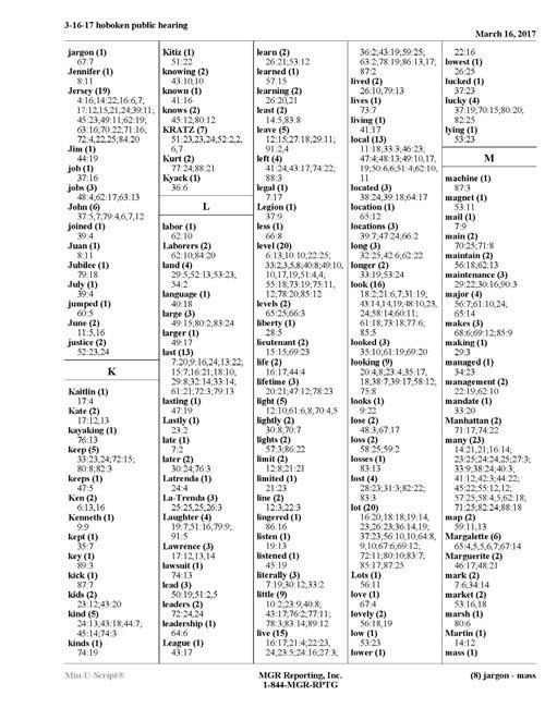
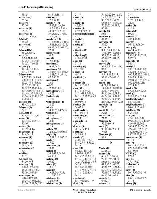


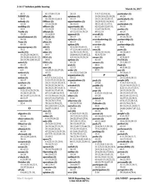
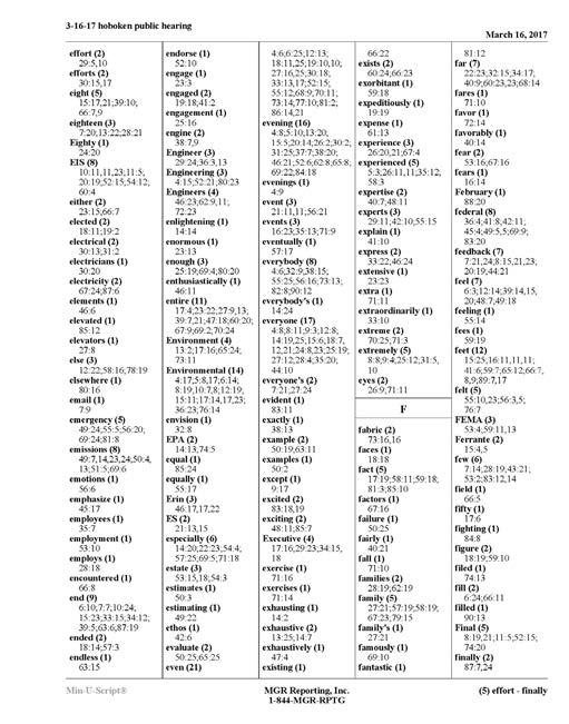
54 PH PH PH PH PH PH PH PH C-54


55 PH PH PH PH PH C-55


56 Urban Design : Comments were solicited at the five meetings / drop-in workshops between April 7 - June 16, 2016 C-56 Appendix C: Public Comments


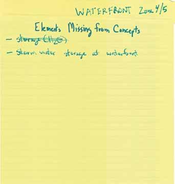
57 Appendix C: Public Comments C-57


58 C-58 Appendix C: Public Comments
![Hoboken, NJ 07030 201-744-9602 cstratton@hobokennj.gov From: Joseph Calabrese [mailto:calabresejp@gmail.com] Sent: Sunday, April 10, 2016 2:06 PM To: dzimmer@hobokennj.com; councilmanbhalla@gmail.](/docs-images/82/85277474/images/59-0.jpg "com; Vijay Chaudhuri; Caleb Stratton Cc: tiffaniefisher@hotmail.")


 for more of their input for usage.")


 into the plan. You can 2 3 All FYI email from resident attending last night.")

59 Hoboken, NJ From: Joseph Calabrese Sent: Sunday, April 10, :06 PM To: Vijay Chaudhuri; Caleb Stratton Cc: Subject: Rebuild By Design use New York's High Line as an example of where they included well-adapted, site-specific landscaping cutting down on water and other resources needed to maintain it. Can we avoid having just an open space area? These areas are not very interesting and are more challenging to use. An example of a mixed use area is included below. It has usable seating areas as well as open space and plantings. I attended the Design Workshop on April the 7th with the CAG and here's my feedback. - I'm assuming the waterfront option is not an option because of cost to implement. - I'm assuming the 15th street option is not desirable because of the difficulty to implement and traffic disruption. - The alley way options were interesting and I would defer to the residents (Garden Street Lofts) for more of their input for usage. It is an alley way and therefore it's not the most desirable area to hang-out. Additional seating would be handy when the farmers market is in play. A green component could also help make the space more attractive. - Can you provide visuals or mock-ups of what you are thinking for the area between the Toll Garage and the Park and Garden building on Garden. There was no real mention of that area during the 7th meeting. It's kind of funny that the alley gets more attention then the Garden street stretch which impacts more folks in the area. - I like the mock-up below for the "partial" Washington street implementation. The alley way solution will only impact a portion of Washington Street. The other solutions seem to be too elaborate and potentially harder to maintain. - Please be sensitive to where restrooms are introduced in the park. Can they be placed near the boathouse where there's a commercial element and away from residential property? - There seems to be a need in Hoboken to provide a playground whenever open space is created. Can we get a better balance of playground, adult and green space? Manhattan does a good job in providing playgrounds that are incorporated into green space as apposed to just adding a blue side and a yellow jungle gym. Here are some examples... - I'd like to see more solutions for the Harborside Park area. I know they're in the works. I'm hoping the ultimate solution will have the berm on the western edge of the park. This should allow for easier access, improved sound barrier from traffic noise, and a better integration with the rest of the park and cove. Can you please try to incorporate some of the original park features (walking paths and plantings) into the plan. You can 2 3 All FYI from resident attending last night. Ken Spahn, PMP Regional Director, Ports & Intermodal Dewberry 200 Broadacres Drive, Suite 410 Bloomfield, NJ w c From: Eric Aldous [mailto:eric.aldous@gmail.com] Sent: Friday, April 08, :45 AM To: dzimmer@hobokennj.gov; vchaudhuri@hobokennj.gov; Spahn, Kenneth <kspahn@dewberry.com Cc: hoboken2nd@gmail.com; Edward Fischer <edfschr@gmail.com Subject: Re: RBD Comments (1500 Garden St resident) and Irish Step at State of City Address Mayor Zimmer and Ken, Thanks for the time and the models last night. Here are my key points (focused on the single option as I do not believe the other two are viable): 1) sloping barrier or structure to the far end of the parks or open spaces outside 1500 garden. This will preserve the water access, views, paths. I am also biased as I don't want to walk out the West doors directly in to some kind of structure. 2) To extent possible run the barrier along the parking garage to minimize impact on public use areas and to keep costs (build and maintenance) low. 3) If possible use the wall with appropriate reinforcements as the barrier in the ally between Bloomfield and Washington. Took a photo this morning on way to work. 4) Keep designs simple, in character of the surroundings, and easy to maintain. We all agree there but some of the thought provoking designs were creative, thoughtful and really scary at the same time. Thanks again for all the work that went into last night. And because it is in the legacy subject line: Mayor Zimmer, my nearly four daughter was thrilled by the thank you letter for the dance performance. She said something along the lines of "a letter to ME from the Mayor!!!, what does it say". Sent from my iphone On Feb 11, 2016, at 8:59 PM, Eric Aldous <eric.aldous@gmail.com wrote: Hello Mayor Zimmer and Mr. Chaudhuri, To clarify how the RBD and Irish Step are linked, they are not. I just want to thank you for inviting the group as my 3.5 year old daughter was thrilled to perform for you and the city resistant s in attendance. Thanks for bringing such a large smile to her face. As for the RBD, I would also like to thank you and your staff for taking the time to come our building on January 21st. I was out of town and unable to attend but Ed Fisher provided me with an update and I was pleased to hear the amount of additional considerations being made around this project. Appendix C: Public Comments C-59


60 Given our building is right at the water, decisions around the project will direct impact us both from a protection standpoint and quality of life. It is tough to balance the need for safety and preserving the waterfront aspect that is one of things that make Hoboken a unique place to live. Given the designs presented to visualize the walls, so I would ask that 3D models of the key design be created. I also like to know the options available if our building falls outside the protected area? We get the largest value from a robust system to deal with excess flood waters while the wall has taken center stage in the conversation, the upgrade and new infrastructure to deal with flood waters should not lose focus. In short, walls can have many consequences and water is unpredictable. As a result, proper measurement, modeling, and stress testing is essential. I know there is a deadline, but rushing to a decision could have many unintended consequences. I look forward to further conversations on this topic as we dig into the details. Regards Eric 1500 Garden St, 7k C-60 Appendix C: Public Comments


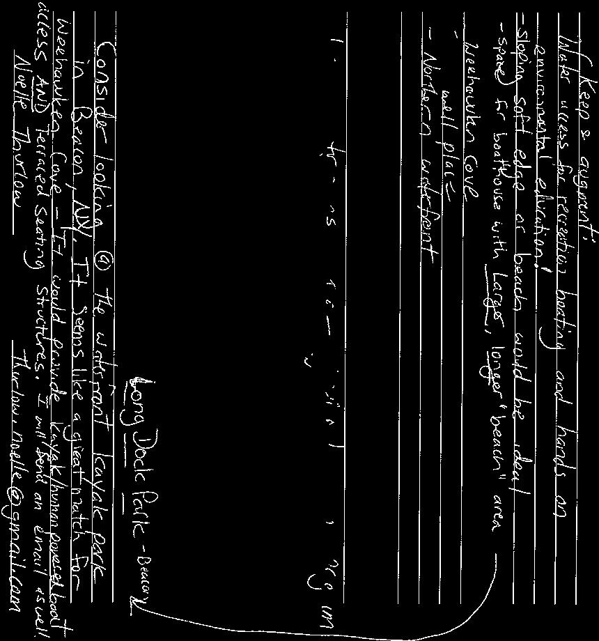


61 Appendix C: Public Comments C-61


62 C-62 Appendix C: Public Comments


63 Appendix C: Public Comments C-63


64 C-64 Appendix C: Public Comments

65 From: Matthew Begley Sent: Monday, December 14, :15 AM Subject: Rebuild By Design - Hoboken Proposals To whom it may concern - I am writing to express my very strong opinion that moving forward with any of the B, C, or D concepts would be a tragic mistake for the entirety of Hoboken. My young family and I specifically moved into Hoboken, due to the proximity to NYC, but also because of the beautiful, unparalleled access to the waterfront and its NYC views. We planned to stay and even decided to purchase in Maxwell Place and have chosen to raise our young family right here in town. Subject: Plan A - Garden Street I am a resident on 1300 block of Garden Street and to my utmost disbelief have been informed of a plan to erect a sea wall on my street. Being from the Netherlands I cannot belief that you think a sea wall can keep any surge out. You cant!! The way water is managed in my country is by directing it from populated areas to non populated areas. None of your options do this. You cannot go ahead with Plan A, as this plan erects sea walls on areas that NEVER flooded during Sandy. I lived here at the time and saw with my own eyes how far the water came up. concept screening comments december 10-31, 2015 We chose a townhome in Maxwell Place as it fit our needs and wants and specifcally thought the North Hoboken waterfront was so safe and beautiful. We stayed throughout Sandy and Irene storms, and had Zero damage to our property - the building and our unit specifically. I do not understand how 3 of the 5 proposed plans would include anything along the North Waterfront where we did not have any signifcant damage or issues with rising storm surge. My unit had water out-front, but it did not even reach the first step of our townhome during the peak of Sandy's fury. There has to be a better, more temporary way, to build proper fortifications laong the North waterfront when an expected event (hurricane, storm surge) is imminent. I agree with the Resist and Delay Strategy, and I think there is definitely more temporary walls that can be setup and fortified prior to an extremely rare surge event that would offer the same level of protection that one of these "permanent wall structures" in the B, C, or D concepts currently offer. On another note, It is very evident, that our investment and many of our neighbors in Maxwell Place would also be significantly de-valued with any restricted access to the current views and waterfront walkway. The property values, and corresponding tax revenue based upon these rising property values would be severely decreased and hurt Hoboken's currrent and future residents. I firmly believe that moving forward with any of the B, C, or D concept proposals would be a serious detriment to the community as a whole. I think we would simply move out of town. None of the designs in B, C, or D are worth the small incremental benefit to the community, specifically the North waterfront Hoboken community by building walls along the waterfront. Regards - Matthew and Carey Begley 1125 Maxwell Place Townhome #6 The fundamental issue with plan A is that 1200 and 1300 block of Garden Street do not flood and do not need to be protected, so why erect a wall??????? It makes no sense and is both morally wrong and not legal. If you are so keen to put up walls then reserve them to areas that actually flood! I will fight this option A with all my energy and if need be with legal action. Rikke 1235 Garden Street From: Joe Rhodes [mailto:jrhodes@stocktonroad.com] Sent: Sunday, December 13, :22 PM Subject: Hoboken Flood Protection Draft Ideas I am writing this in response to the various draft ideas for the coastal flood protection in Hoboken. I live on Garden street between 12 th and 13 th streets. I vigorously oppose Concept A which is an outrageous affront to the property owners and town esthetics/logistics along Garden Street (which is some of the most valuable single family real estate in Hoboken), and indeed a large portion of North Hoboken. Do we want to drive down the value of this property and drive away these high tax paying residents and deface what is currently one of the nicest areas in town? Deface the Northeast corridor which is enjoyed by so many. From: Rikke Frojk Lauridsen [mailto:rikke.frojk@hotmail.com] Sent: Sunday, December 13, :47 PM This concept appears to come at significant cost to the people that live in this area of town, which is not equitable. It also provides the least amount of protection vs a storm surge. So, why is this even on the table? It frankly seems completely ridiculous and short-sighted to build a partial wall that will simply keep the water pinned on certain residents to protect some others. Do we want Hoboken to be a first-rate town? Let s not select a plan to do things on the cheap as Hoboken has done so often in the past. The cheapest is not the best way. Let s choose a plan that best protects Hoboken and doesn t come at the extreme sacrifice of one set of residents. Joe Rhodes Joe Rhodes 1234 Garden Street, Hoboken (o) (c) jrhodes@stocktonroad.com From: Christiaan Van der Kam [mailto:cvanderkam@unigestion.com] Sent: Saturday, December 12, :32 PM Subject: Plan A involving Garden Street I live on 1235 Garden Street and have just found about this preposterous plan. We live on blocks where the Sandy surge never hit as these blocks are above the sea level. By building this wall on our blocks you effectively push the water to an area where it never would get to. So suddenly you make it our problem to fend off areas that are below the surge level. I am shocked this option is even on the table. And we will fight this option with tooth and nail, including legally. Christiaan van der Kam 1235 Garden Street Hoboken From: Sean Kron [mailto:seankron@pira.com] Sent: Saturday, December 12, :16 AM Subject: Rebuild by Design Questions 1. In the 5 concepts can you provide the assumptions underpinning the approximate percent of study area within the 100-year coastal floodplain receiving flood risk reduction benefits? Specifically, the denominator (i.e. total population and the split btwn Hoboken and Weehawken, if applicable) and the numerator (i.e. those receiving reduction benefits or conversely those not receiving reduction benefits and who would not be receiving benefits). Or point me to where the documentation is that includes this information. Thank you. Regards, Sean D. Kron From: Hartmut Grossmann [mailto:hgrossmann25@gmail.com] Sent: Saturday, December 12, :16 AM Cc: dzimmer@hobokennj.gov; rbhalla@hobokennj.gov Subject: Rebuild by Design/ Comments on Concept Presentation/December 10, 2015/Hoboken Dear Mr. Rosenblatt, I am a Hoboken resident, who has been living here for about 7 years and intends to live here for the very long term. I am invested in the flood reduction efforts in Hoboken and, as a matter of general principle, strongly support the project. I attended the above-referenced meeting including the presentation and discussion at the tables, which I found both encouraging and extremely disturbing at the same time. Here are my comments: 1. Delay/Store/Discharge While certain details seem to be open including potential additional sites, I found the information encouraging, especially the potential of a 1 million gallon storage tank on the BASF site. 2. Resist I am taken aback and clearly shocked where the presenters from the engineering firm in substance and tenor took this. Plans A and E were virtually dismissed as insufficient, with a bit of lip service to "substantial risk reduction". Plans C and D were a priori described as essentially not feasible for reasons of cost, complexity, engineering challenges, and maintenance. The presenters seemed to be clearly invested in Plan B. That almost appeared as a foregone conclusion. 3. Plan B is unacceptable in its current form for both residents at the waterfront and Hoboken as a whole/the walls destroy the waterfront and thus a core attraction and feature of life of Hoboken The uninterrupted (with a current small exception) waterfront of Hoboken is a jewel of the city. It is used by all residents for recreation, exercise and enjoyment and links up with the waterfront in Jersey City, Weehawken and beyond. Plan B essentially destroys access to to the waterfront in the North, where there is great activity of residents and their families including Pier 13 (food and drink). As one resident at the meeting who lives several blocks away from the waterfront put it: "We came to Hoboken in 1971 and we did not have a waterfront then. This proposal is a regression to that time". It is completely perplexing that a 12 foot wall would be built at the North end of the city under this plan when, apart from the Weehawken cove, this part of town was spared from the floods in Sandy, and most damage occurred on the south side. Questioning this at the table discussion, vague or incoherent answers were given by the engineers: "the requirements are now higher and go beyond Sandy". When I asked whether the walls could be lower, say, 3 or four feet and perhaps avoiding the 3 1/2 year total rebuild of infrastructure: "No, the Feds" would a have a problem with that". Which "Feds"? "Congress" (??!!). Also, lowering the walls would be "unfair to the other competitors for the grant money". What is that supposed to mean? Bidding rules would be violated? Surely not. Otherwise, Concepts A and E would per se be violative! I just hope that there are no self-serving motives by the engineering firm at play here. 4. Next steps My assumption based on the presentation by the engineers is that the 5 concepts will be reduced to A, E, and B. I was told that previously there was not meant to be "mix and match" between design aspects of the concepts. I would strongly suggest that this limitation be lifted for the next stage and a better compromise explored (starting from concepts A and E, which has 90% reduction after all). There is no perfect solution here. In any event, the extreme Concepts of B, C, and D are unacceptable. It makes no sense "protecting" Hoboken by destroying its attraction. From: Leslie Howard [mailto:leslieahoward@gmail.com] Sent: Thursday, December 10, :38 PM Cc: Peter Cunningham Subject: Comments: RBD Concept Screening Public Meeting Leslie Howard leslieahoward@gmail.com 1200 Grand Street, 519, Hoboken, NJ Leaving this evening's meeting, my foremost concern is a matter of funding allocation, not design. I fear that DSD implementation will not occur b/c it will not receive funding from the $230mil grant and will thus be left unfunded. 1. Was told that the process is not advanced enough to have reliable cost estimates for Resist and DSD components. 2. Was told that in terms of allocation the $230mil, Resist components would take priority over DSD components because "when will the City ever again have $230 mil to 'close the envelope?'" 3. Built into that statement is an assumption that the costs of implementing the DSD components are far lower than implementing the Resist components; and that the City will have other means to fund the DSD components in a comparable timeframe. 4. From this lay person's perspective, implementing DSD (as designed) would likely cost at least as much as Resist Concept A if not more. Deconstructing streets, parking lots, football field, buying and installing tanks & pipes, re-routing existing sewers, then building discharge pipes & pumps that circle the City edge to reach the river?? The southwest, northwest and western edge flood on a regular basis from heavy rainfall alone. AND there is more residential & commercial development on the horizon making the frequent flooding disruptive to even more people. Storm surges occur--in theory--every 100 or 500 years, even though I believe we should expect increasing frequency during the next 50 years. I would turn the statement around: When will the City ever again have $230mil to finally fix rainfall run-off flooding? As for Resist design options, I favor Concept A1. My rationale is again grounded by financing. Frankly, none of the concepts seem feasible within the $230mil grant limit. When asked which of the concepts can be built for $230mil, the design firm representatives looked at each other and joked, "None of them. Well, we don't know yet." Therefore, my inclination is to choose the concept that has the greatest chance of actually being built and which requires the least maintenance. Additional Resist components can be added in the future, i.e., future beyond this grant, to gain incremental improvements that increase population percentage from 86% to 90%. -- ~~~~~~~~~~~~ Leslie A. Howard leslieahoward@gmail.com mobile C-65 Appendix C: Public Comments


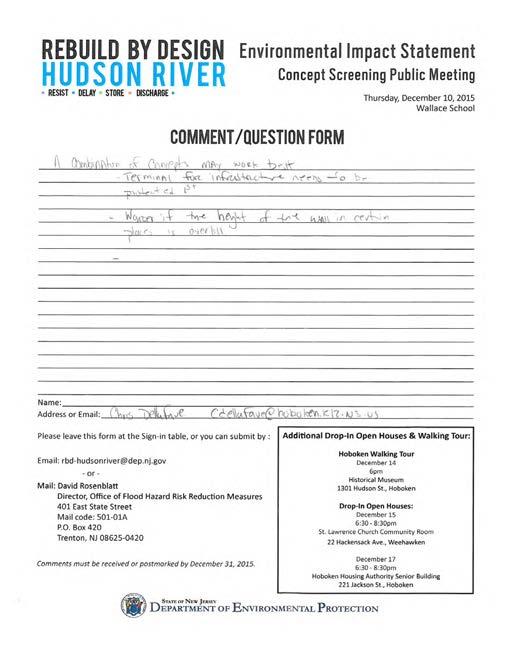
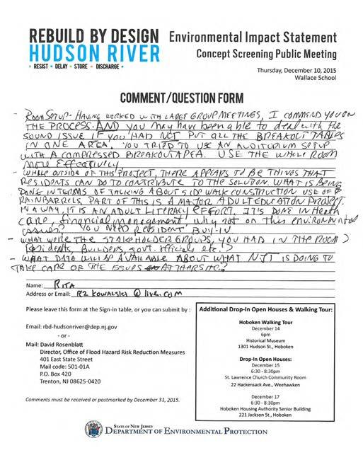


66 C-66 Appendix C: Public Comments

 asked for these funds or asked to pursue a strategy to combat hurricane storm surges.")

67 From: Loni Blair Sent: Tuesday, December 22, :28 AM Subject: IMPORTANT To whom it may concern: As residents of Hoboken since 2002, we have grave concerns about the Rebuild by Design Project. All five concepts for the Rebuild by Design project are completely unacceptable. No one in Hoboken (other than the Mayor) asked for these funds or asked to pursue a strategy to combat hurricane storm surges. There has been no scientific proof presented that this surge is ever statistically likely, and moreover, no proof has been presented that these extreme concepts would successfully combat these storm surges, if they were to ever happen. Please do not destroy the one valuable asset this city has which is its view and the charm of the tree-lined streets. Also as owners of an expensive piece of property right across from the waterfront, please do not destroy our value in our property. All of the concepts contain a wall and/or an erosion to the quality of life for all Hoboken residents. We respectfully reject all five concepts and ultimately reject these funds. Thank you for your time in reading this letter. Sincerely, Theo and Loni Garatziotis From: Cathy McCabe [mailto:kikomccabe@optimum.net] Sent: Tuesday, December 22, :41 AM Cc: avonbythesea@optionline.net Subject: Rebuild by Design-Hudson River: Comments Dear Mayor Zimmer and Mr. Rosenblatt, Thank you for the opportunity to share comments about the Rebuild by Design-Hudson River Plans proposed for Hoboken. We were able to attend the session held at the Hoboken Historical Museum but unfortunately due to the size of the group that attended, and the layout of the event, few answers could be provided. We were on business travel for the Jackson Avenue event and could not attend and are submitting our comments here. First, let me begin by saying we want to help protect Hoboken, a place we have come to love in our over four years living here. However, we oppose all five plans and do believe there could be a much more creative, less drastic approach to protecting Hoboken from a potential Hurricane Sandy-like surge other than any plan that would create permanent foot walls either on the Streets of Hoboken or Hoboken s waterfront. Second, we question why only one firm was chosen to provide five options rather than five firms (or some number) chosen to compete to provide the best possible option to consider. In the corporate world, when a firm is looking for a service, a request for proposal is prepared and competing firms submit their best options in hopes of winning the bid. That does not appear to have happened here. Yes, Hoboken had flooding due to Hurricane Sandy and homes, cars and businesses were damaged (we, in fact, lost our car to the flooding). Yes, we lost power for many days. But so did hundreds of thousands of others throughout NJ and NY as well as 20 plus states. Yet, others are not considering permanent foot walls throughout their towns, including our neighbors across the river in NYC. We left a very desirable neighborhood in the West Village four years ago and friends questioned why we would ever leave NYC for Hoboken. We wanted a little more space but an urban setting. We explored Hoboken at the recommendation of friends who have lived on Bloomfield Street for 25 years and encouraged us to consider it. We were drawn to Hoboken specifically for the beautiful and unobstructed views of Manhattan and the short commute to Manhattan. Though the price for our condo at Maxwell Place was more reasonable than NYC for the space, it was still a considerable amount as are our taxes. We have come to love many things about Hoboken and support Hoboken locally the restaurants, boutiques and shops, fitness, etc. The beauty of Hoboken s magnificent waterfront is enjoyed by all residents who run, walk, play with their dogs, push their babies in strollers and more. To create a wall of any sort that goes down a tree-lined street like Garden Street or obstructs the open, unobstructed views and access of the waterfront would impact not just those of us that live on the waterfront but all residents that benefit from the beauty. This would forever change the appeal, character and charm that Hoboken has worked hard over the years to create. This would detract outsiders from moving in, detract from Hoboken as an emerging destination vacation and business meeting place, reduce home values and hence, reduce tax revenue to the city. Options A-E have been presented as concepts and concepts that have not been thought through as to their long term impact on Hoboken. Building permanent walls is an extreme measure to combat a once in a one hundred year event and we implore you to explore other more creative and less drastic options. There are new and innovative ways to manage floods that do not permanently deprive the community of enjoying the very things that have created a surge of gentrification here. Preserving what has made this community special for our families, friends and visitors should be the first priority and non-negotiable on proposals. Sincerely, Cathy McCabe & Jill Popovich 1125 Maxwell Lane, unit 570 Hoboken, NJ Sent from my iphone From: Tom Garske [mailto:tpgarske@gmail.com] Sent: Tuesday, December 22, :17 PM Subject: Hoboken Wall Building a wall down a street is a ridiculous solution in today's modern era. Are you trying to put us back to the stone age with this idea? Why is no one thinking about technology? Dig up the streets that are the lowest area and that get water the most water. Put in a separate large 48" pipe in these streets that is connected to a separate pumping station to move the water some place else. Blocking water is primitive and who ever came up with that idea should not be working in this sector. Regards, Tom Garske From: Roseanne Dickovitch [mailto:rdickovitch@gmail.com] Sent: Tuesday, December 22, :41 PM ; Tiffany Fisher; Dawnzimmer@gmail.com Subject: THE GREAT WALL ON THE HOBOKEN WATERFRONT I live at 1500 Garden Street and watched the water come over the railing with Sandy... it was minor to my building... the bulk of the water in Hoboken come up out of the sewer system... so number one the valves that lead runoff into the river must be CLOSED at the time of high water conditions in the river and number two... wouldn't it make sense to build a new multi town sewer plant on the top of the ridge and close down the one in a flood zone?... If you build this wall you will destroy the beauty of our neighborhoods... and you will negatively impact property values... Harborside Lofts and the Hudson Tea Building have many first floor residences that you will directly impact in a negative way...and if you build it you will have to maintain it...i have been to Red Hook and seen their ugly wall... we can't even get new light bulbs put in the lights along the walkway and by the kids playground... they have been out for 8 months... and some of the light posts on the walkway have electrocuted dogs and we can't get that fixed or maintained... thanks Roseanne Dickovitch 1500 Garden street Apt 4D... From: Rachel Chang [mailto:rachel@byrachelchang.com] Sent: Tuesday, December 22, :07 PM Subject: Blocking Hoboken Happiness Dear Rebuild By Design, C-67 Appendix C: Public Comments
68 When I moved across the country on my own and decided to settle in New Jersey a decade ago, I was so relieved to find Hoboken. It was tough being so far from family and friends, learning to navigate urban life, and experiencing seasons for the first time! But when I first stepped foot in Hoboken, it immediately felt like home. I started out renting downtown in a lovely little studio on First Street between Clinton and Grand. I never anticipated staying here permanently, but five years passed so fast that it seemed it was time to invest in property. Fortunately, my parents were looking to invest in property too, so we decided to go in on something together. And despite their hesitations and skepticism about the New York City-area, they embraced Hoboken on their visits as well. (On one of my Dad's visits, he made so many friends around town that he got more "Hello"s than I did when we walked around after I got back from work!) After much research (and a serious dip into savings), we settled on Maxwell Place and competed to get a spot pre-construction because it seemed like the only safe investment. Back then, all three of us had to be on two phone lines to finally get through and get a number to get spot! But it was the only space they felt comfortable investing in on the entire east coast. We were so grateful. And now, six years after moving in, they've been pleased with their investment and I've felt so lucky to be a homeowner in the Hoboken community. And proud 11-year Hoboken resident. The plan last year to put the sewage pump literally in my front yard put a huge dent in our Hoboken Happiness, but we accepted the inconvenience and possibly devaluation in property because the pump would help our neighbors. My understanding at the time was that it would help alleviate all the problems with the flooding, being a waterfront community, so to hear this plan about the 12-foot wall was quite a shocker. The fact it was even proposed and presented to the City of Hoboken is unbelievable. The whole draw of Hoboken, which has been at the root and core of the New Jersey Gold Coast community, is the waterfront and literally blocking it seems like the ultimate detriment to our community. I know there has been so much muddled in the politics of this issue that I m confused about what the truth is and wanted to inquire what exactly is happening, so that I don't fall prey to all these rumors. Unfortunately, holding all these meetings during the holiday week and requiring a "deadline" of comments by the end of the year just seems like this plan is trying to fly under the radar while everyone is distracted. Because of my work schedule, I wasn't able to make any of the meetings as soon as they were announced. Had I been able to, I would have been at all three particularly the one that spilled outside the Hoboken Historical Museum. I think the fact this many people were able to make an impact should say something about the community's response to this and I hope you won't let that all just go without taking it into account, as it felt like it happened with the pump. Of course, I understand Hoboken needs to alleviate the flood problem. We can't have Sandy happen again. But I'm just wondering if there's a way to put it in a more discreet place to minimize the impact on the residents who are so grateful to call Hoboken our lovely and serene home. Looking forward to the answers! Thank you, Rachel 1125 Maxwell Lane Hoboken NJ From: Mcintyre, Robert F [mailto:rob.mcintyre@bnymellon.com] Sent: Tuesday, December 22, :28 PM Subject: Hoboken Flood Preparedness As a Hoboken resident, I have been familiarizing myself with the concepts that have recently been proposed as possible solutions for Hoboken's potential future storm flooding. I have sincere concerns over the implications of what is referred to as "concept A," which includes building a wall along an interior (not along the coastline) street. I do not understand how this solution would not adversely affect the homes on the "exterior" of the wall. Most of them had no previous flood issues and this solution certainly introduces a new level of risk for future flooding where there was none prior. Why cause a new problem to solve the first one? Secondly, there must be a solution that is not so unsightly and causes unnecessary challenges and potential safety risks that such a physical barrier would introduce. There was a past proposal which included a wall along the coastline. A physical barrier there, should a barrier solution be deemed the most effective, seems to alleviate the negative consequences from the "concept A" proposal. Please consider this input and/or provide proven assurance that new goosing risks will not be introduced by the determined solution. Rob McIntyre BNY Mellon Corporate Trust cell The information contained in this , and any attachment, is confidential and is intended solely for the use of the intended recipient. Access, copying or re-use of the or any attachment, or any information contained therein, by any other person is not authorized. If you are not the intended recipient please return the to the sender and delete it from your computer. Although we attempt to sweep and attachments for viruses, we do not guarantee that either are virus-free and accept no liability for any damage sustained as a result of viruses. Please refer to for certain disclosures relating to European legal entities. From: Stephanie Dearmont [mailto:sdearmont@aol.com] Sent: Tuesday, December 22, :07 PM Subject: Comment re: Concept A of the "Resist Delay Store Discharge" flood plan proposal for Hoboken REBUILD BY DESIGN HUDSON RIVER Environmental Impact Statement Concept Screening Public Meeting COMMENT/QUESTION FORM December 22, 2015 Dear Mr. Rosenblatt: This comment concerns Concept A of the Resist Delay Store Discharge flood protection proposal for the city of Hoboken. I urge you to reject Concept A for the following reasons: 1.) The plan does not protect the north eastern section of Hoboken, including areas that flooded during Sandy and will flood again. 2.) Driving an 8 foot wall down the center of a residential street will create a ghetto followed by a ghost town, destroying the financial lives of hundreds of people. Property values on Garden Street and affected cross streets will plummet. Adjoining unprotected areas like upper Bloomfield and Hudson at 14 th Street will also suffer property value declines. For some, this will be economically ruinous the value of the property will sink below its mortgage value, causing some to abandon their homes and/or declare bankruptcy. While this plan is considered the cheapest, I am sure that if the destruction of property value were factored in, it would be far from cheap. 3.) There does not seem to have been any consideration of how the wall will affect the delivery of essential services to the street, which is entirely made up of brownstones with no side yards or alleys. With vehicular traffic made impossible by the wall, there is no way fire trucks, sanitation trucks or vehicles for the disabled or elderly will be able to reach these homes. 4.) The plan treats similarly situated people differently. If you have the bad luck to live on the east side of Garden Street, you will not only experience the financial, aesthetic and safety issues caused by the wall, but you will also likely flood. West siders will helplessly watch their neighbors across the wall fill up with water in a Sandy-like scenario. This is just horrific. 5.) Many people in the area are still unaware that these plans are under consideration. Very little effort has been made by the city to inform even those directly affected by the concepts. From the initial announcement on the 10 th, we have only been given three weeks (during the holidays) to react to what may completely change our lives and our futures. 6.) The mayor s rhetoric surrounding Concept A has been divisive, pitting neighbor against neighbor and uptown against downtown. Being called lucky for having not flooded during Sandy (which is untrue for many of us), we have been called selfish for choosing Garden Street over the rest of Hoboken. This kind of language just reinforces the feeling that this plan is being shoved down our throats and that our homes, families and lives don t matter. 7.) This is a historically important neighborhood, one of the best examples of late 19 th and early 20 th urban domestic architecture in the area. To destroy it in the hope that some, not all, of Hoboken will flood less, seems particularly cruel and thoughtless. We will not accept the unnecessary and inequitable blighting of our neighborhood and therefore cannot accept Concept A. No response to the devastation of a city should require devastating one of its most significant neighborhoods. Sincerely, From: K T [mailto:tengkevin@hotmail.com] Sent: Tuesday, December 22, :51 PM Cc: K T Subject: Feedback for Hoboken Concepts Screening Stephanie Dearmont To: David Rosenblatt Director of Flood Hazard Risk Reduction Measure Dear David, My name is Kevin Teng and my family lives in the Maxwell waterfront community of the city of Hoboken. This is the most beautiful place to raise my family and invest my future to my community and Hoboken. I am writing to you to express my deepest concerns about the "Five Concepts" for flood protection funded by the federal aid of 230 million. After I attended the meeting last Tuesday, the 15th of December, I would like to share my concerns with you. I am not convinced at all by any of the five concepts in general and more specifically to the concept D and E. These two options are the most costly proposals to begin with. The effectiveness of flood protection of the 8 to 15 feet sea wall along the waterfront is very much questionable in providing flood protection long-term because the 18 feet sea wall can't assure us the sea wall is high enough to block the floods should next hurricane is multiple times worse than Sandy. Besides, once the floods come into Hoboken and they could not go back to river when the hurricane left because of the sea walls. The alternative to the high sea wall is to focus on draining and/or raising the the ground of low area in the town. Draining and raising the ground should be able to address the flooding issue long term. If there are a few water pomp stations on the flooding area of the west side of Hoboken, it would provide much more flooding protection than the sea walls. What is certain to me from the concept D and E is they are going to strip the privilege Hoboken residents have-access to the Hudson River waterfront. The waterfront is part of life of all residents in Hoboken and not just to the residents in maxwell place or tea buildings. In a typical spring or summer day evening, you will see people from all parts of Hoboken to the waterfront having their kids play, socialize with their friends, or neighbors, and watch the beautiful sunset. When the costs go over and beyond the 230 million federal funding, tthe additional costs will have to funded by higher property taxes or issuing bonds. High property tax will drive people to move out of Hoboken instead of staying and raising families here. Issuing bonds will deteriorates the fiscal condition of the city of Hoboken. Both will make Hoboken as well as Maxwell Place much less desirable place to raise families. We would want to make Hoboken as our hometown and people become rooted here and raise family here. Your decision matters and we need your help! Thank you for your time. Best regards, Kevin From: ben park [mailto:benpark.us@gmail.com] Sent: Tuesday, December 22, :34 PM Cc: carter@outsidenewyork.net; benpark.us@gmail.com Subject: Comments on Hoboken Rebuild by Design Concepts Dear Mr. Rosenblatt, As a resident of Hoboken I am sending this to you as my official submission of comments on the Rebuild by Design proposals. Hoboken is a historic city, and the residential streets in the northeast of the town have been an integral part of the character of the city for more than a hundred years. It is the combination of these attractive streets and their vibrant community just ask the thousands of people who visit the north-east of Hoboken from neighboring towns what a wonderful place it is at Halloween for example along with the waterfront and the large buildings that make the town such a special place to live in. Garden Street is at the center of this community. Concept A would divide and spoil this neighborhood through the construction of a storm wall on Garden Street. This plan is flawed for so many reasons it is difficult to know where to start. 1. Increase flood risk where it was lower without a wall: a. The wall in concept A introduces flood risk to neighborhoods which were not flooded by Superstorm Sandy. I live on Garden Street and I was extremely fortunate not to have a drop of water in my sump pumps as a result of the storm. The floodwaters stopped one block from my house, and my fear is that the proposed wall would act to channel water into this neighborhood in the event of another large storm. The Dewberry engineers claim that that will not be the case. They suggest that in the event of a storm the waters will rise uniformly, much as happens as the volume of water increases when you fill a bath. But their logic completely ignores the impact of force on a body of water, and when challenged on this at one of the recent community meetings by neighbors who are engineers, they could not respond. They tried to suggest that water does not flow uphill, but that is simply not true. Go to the beach as tides rise water does flow uphill as a result of tidal force. Any calculation of what will happen to water when confronted by a wall cannot just take into account volume; it also has to consider the effects of force. And if there is one thing we know about storms, it is that they are highly unpredictable. We do not know how strong they will be, or from which direction, or directions, they will hit us, or even for how long. Given this, it seems foolish to construct an artificial barrier which could act to channel water along it. And I would point out that if water flows along the wall and gets to 13 th Street, it will then flow downhill very easily onto Park and down into the western side of Hoboken, defeating the supposed purpose of the wall. b. Concept A will cost a lot of money maybe less than some of the other options but it will also deliver the least protection to the Hoboken community as a whole. The original maps that were handed out at the first community meeting acknowledged that this option resulted in the least protection, ignoring almost 15% of the city. When it became clear that there was resistance to the concept, the words on the maps were changed in what I can only assume was a cynical attempt to spin the story in a more positive way and to cover this fact up. See a copy of the original below the revised version can be seen on the website. c. I would point out that the concept maps contain errors. The berms around Weehawken Cove that have been discussed on numerous occasions are not on the maps. I raised this with a representative of Dewberry at a community meeting, and she agreed that this was a mistake. This does not exactly fill me with confidence what else has been missed and will suddenly appear on the next drafts? 2. Public Safety: a. 14 th Street and 15 th Street are major east-west arteries in the north of Hoboken. Closing them off with gates will make evacuation of residents in an emergency much harder and will close off two important routes for police, fire and ambulance services to move around the city during a time of crisis. They would be forced to use the narrower and tree-lined cross-streets as alternatives. We all know that trees get blown over and branches come down in big storms. That could happen on any of the narrow cross-streets during a future storm, closing off those streets as well to emergency workers. Our public safety teams have a hard enough job during a major storm without tying their hands behind their backs by closing off important routes around the city. b. For a wall to work properly, the join between the wall and the gate buried in the street has to be flush. This will require that either the wall is built right to the edge of the kerb, or that the sidewalk somehow becomes part of the gate. If a wall is built, pedestrians will either have to walk out into 14 th Street to cross Garden Street going east or west, or be exposed on a section of sidewalk on the lowered gate which may be difficult to distinguish from the road surface. 14 th Street is extremely busy with heavy car, bus and truck traffic. There is a pediatricians office and a school at the intersection of 14 th and Garden, and another school a block away. There are plans to put a Trader Joe s store at 14 th and Willow which will just add to foot traffic. As a result there are a lot of children, parents with strollers and general pedestrian traffic using the intersection of Garden and 14 th all the time. Ask the police and they will tell you that drivers pay next to no attention to the crosswalks today and people are hit at this intersection fairly frequently. Adding a wall will just make the Garden / 14 th intersection even more dangerous than it already is. c. A wall on Garden Street will impede the ability of fire, police and ambulance personnel to access homes behind the wall and will slow their response times. d. A wall, however low, effectively creates an alley, and offers a place for people to hide behind who want to cause mischief. At night the street is already not well lit. I have 2 young daughters and my wife is registered legally blind, and the idea of there being a wall on my street makes me concerned for their safety. e. A wall would also remove the ability to quickly cross the street in the event of a problem, adding another element of danger. f. A wall would make it harder for elderly and disabled members of the community to access their homes. It would no longer be possible to drop someone off outside their house. I would point out that, in addition to my wife s disability, there are 2 other people with disabled license plates for their cars living on the 13 block of Garden Street. 3. Day-to-day living: a. A wall will make the job of the City s sanitation workers harder and will inevitably slow them down they will have to walk back and forth around the wall to collect garbage and recycling bins at night. The sanitation crews also collect larger items (old furniture etc.) from the street edge during the day what are the residents supposed to do with these go and dump them in front of someone else s house who doesn t live behind the wall? b. In the event of snow, residents are required by law to clear the pathway in front of our houses. Where are we supposed to put the snow if there is a wall in front of the house, and how will it ultimately get cleared away by ploughs? c. A wall will increase the danger of flooding during rainstorms by blocking the ability of rainwater or snow-melt to drain off into the street to then be channeled to the storm drains. Unless the entire sidewalk of the east side of the 13 block of Garden Street is dug up, re-pitched and re-laid (adding to the cost of the project) it will not be possible to ensure that rainwater and snow-melt runs off into the storm drains at the ends of the block, rather than backing up and flooding houses and basements. d. Building a wall will make access much harder for moving in and out of houses, taking deliveries of pieces of large items such as pieces of furniture, and for contractors doing work in homes. e. Parking is already at a premium in northern Hoboken - a wall would inevitably mean a loss of parking spaces when the reality is that the city needs more. f. The attractive planters or benches that we are told will be built rather than a wall will attract graffiti, and who would look after them? Will that be the responsibility of the city or the local residents? 4. Street infrastructure: a. Hoboken s under-street water, sewage and gas infrastructure is in a perilous state. There are numerous water-main breaks and half the time Suez/United Water doesn t even know where the pipes are. If a wall is built how will repairs be done will Suez/United Water/PSEG have to demolish and then replace the wall if they have to get under the street? b. The water supply pipes into the houses on the 13 block on Garden Street are, in many cases, the original lead infrastructure put in when the houses were built in the early 1900s. As such they are extremely fragile. A couple of years ago the water pipe to 1302 Garden Street was crushed by the weight of a small contractor Bobcat being used to dig a trench for an oil tank to be removed. Given this, it is reasonable to expect that a solid and heavy concrete wall could crush these pipes. As a result, before any wall can be built, all of these pipes would have to be replaced, adding further to the cost of the project. 5. Northern Hoboken Historic District: a. Garden Street south of 14 th Street has been a part of the NJ DEP Historic Preservation Office recognized Northern Hoboken Historic District (ID#5414) since it was established in This status needs to be taken into consideration given the radical effect that Concept A would have on the street. b. Garden Street is a pleasant tree-lined street. Part of the plan to reduce flooding is to encourage the planting of more trees. And yet building the wall would have the opposite effect the trees on the east side of the street would have to be cut down, removing the shade and moisture uptake that they provide. c. In the past when residents have asked for permission to add a floor to the top of their houses on the 13 block of Garden Street, they have been turned down on the basis that it is part of the Historic District and the ONLY uniform block in Hoboken - all of the houses are the same height and construction. It is clearly applying a double standard to say that the character and uniformity of the street needs to be protected from building up, but not from building a wall down the street. d. If protecting our communities is the goal of this process, how can the concept which provides the least protection for both Hoboken and for our neighbors in Weehawken even be given serious consideration? 6. Space constraints: a. It would seem to me to be much more logical to try to keep water out of Hoboken in the first place, rather than to try to deal with it by building artificial walls to stop water after it already has broken in. If that has to be the plan then Hudson Street is a more practical place to build a wall. While Garden Street is narrow and single lane, Hudson Street is more than twice as wide. The sidewalk on the eastern side of Hudson Street is also at least double the width of that in front of the houses on Garden Street. It would be possible to build a wall on the Hudson Street eastern sidewalk without impeding pedestrian traffic or losing parking spaces, and the wall would not obstruct houses. Any gates that had to be built at the intersection of Hudson and 14 th would also have much less impact on the ability of the emergency services to move around the city. C-68 Appendix C: Public Comments

69 I could go on, but to me it is very clear that concept A is quite simply a bad choice. Walls divide communities and drive wedges between them. I have seen the pernicious effects of this in Belfast, Northern Ireland. This is not the path that we should be exploring to protect Hoboken. We need, and I would support, a solution for the whole city, not one that creates new risks where they weren t before, and that ignores other areas altogether. I strongly encourage the NJ DEP to take the factors I mention above into consideration, and to come up with a plan that would both protect the entire Hoboken community, while not endangering the public safety of any of our citizens as concept A clearly does. Sincerely, Ben Park and attended a session but will say that it is all still a little hard to understand. What is clear is that multiple proposals include permanent walls along the waterfront. This is absolutely not something that I could support as this would have a tremendous impact on the access to the waterfront and the views of the city which is one of the main things that makes this city so special. This would affect the amount of visitors coming to the area for the views as well as affect the tax revenue for the housing affected as property values would decrease. I would like to see C and D removed and perhaps even B from the final round. Ultimately the best solution would be some type of barrier that could be retracted perhaps so that it does not impact the signature views and the overall joy experienced by those who walk along the waterfront. Thank you for taking my concerns into consideration as this moves to the next step. Sincerely, Gina Giannasio 1125 Maxwell Lane Hoboken, NJ On Wed, Dec 16, 2015 at 6:39 PM, Schwarz, Frank <Frank.Schwarz@dep.nj.gov wrote: The Rebuild By Design Hudson River project website has been updated. Based on comments received, we have reduced the file size of the 5 Concepts for download. The new file is located in the Public Meetings Section and is titled: 5 Resist Concepts and Delay, Store, Discharge Strategy 11 x17 Handout (pdf, 33 Mb). Please note that while it is significantly smaller, the file is still large. Subject: FW: the "landline" situation I mention last time in Hoboken Original Message----- From: still moreinfo [mailto:stillmoreinfo@gmail.com] Sent: Wednesday, December 23, :36 AM To: Reinknecht, Dennis Subject: the "landline" situation I mention last time in Hoboken... Hi Dennis, From: Wytiaz, Beth [mailto:elizabeth.wytiaz@bankofamerica.com] Sent: Wednesday, December 23, :18 AM Subject: Hoboken rebuild by design resident feedback David Rosenblatt, I am writing to express my concern over some aspects of the proposals under the Rebuild by Design project. I am certainly excited about the potential and strongly believe that we need to protect the city against climate change. That said, I have spent some time looking over the plans Sincerely, Beth Wytiaz Hoboken resident and homeowner From: Gina Giannasio [mailto:junkmail.gg@gmail.com] Sent: Wednesday, December 23, :47 AM Subject: Re: Rebuild By Design - Hudson River Project Website Update I would like to provide feedback to the recent meetings, drawings and concepts for the Rebuild by Design Hudson River project. In my opinion the city of Hoboken should not make use of the $230 million bond if it means moving forward with any of the current designs. A rush to spend money because it is there (and it is not a gift, but monies that need to be repaid) is a complete waste of our dollars and will surely put the city of Hoboken on path to decline yet again. I am opposed to any walls that are directly in front of residential or commercial buildings in which the jewel of Hoboken (the Hudson River) is completely cut off from view while walking. The city and several groups worked hard and long to maintain that open view to the public and any design that removes that view is just unacceptable. So that also means the burms, the trees but most especially any walls. If I had to choose I would move forward with A or E with many modifications. In my opinion rather than trying to keep the river out which is most likely an expensive losing battle, use the money to have the areas that do flood build higher, buy people out, let the market decide that those areas are no longer economically viable. To purposefully move forward with anything on the river that will most certainly have a negative impact on real estate values which will translate into a negative impact on Hoboken as a whole is irresponsible. It takes a painfully long time for a city to recover from a long economic decline (i.e. Hoboken not that long ago) but a very swift, ruthless time to go into decline. To willfully move in that direction based on a lot of what if's is ludicrous. Additionally, please see that a link has been established to allow you to provide comments on the concepts either by or by printing the comment form and mailing. This is also located in the Public Meetings Section. Also note that there is one more Public Drop-In Session this week. The session information is as follows: December 17th 6:30 8:30 pm Hoboken Housing Authority Senior Building 221 Jackson St., Hoboken Thank You Frank Schwarz Project Team Manager Rebuild By Design Hudson River Project For additional information concerning the Rebuild By Design Hudson River project go to: rbd-hudsonriver.nj.gov New Jersey Department of Environmental Protection Office of Flood Hazard Risk Reduction Measures 501 East State Street-1st Floor Mail Code A P.O. Box 420 Trenton, NJ Original Message----- From: Reinknecht, Dennis Sent: Wednesday, December 23, :25 AM The text BELOW the "====" line I really wish to NOT be disseminated so that thieves are NOT inspired to steal and vandalize residences in quest for more copper. If by chance, you should feel that I'm advocating US gov't nationalize the landline system of telecommunication, eliminating the profit motives that refuse to maintain it; I'm fine with that although I feel telco biz can rise to the occasion to reclaim copper. There have been BIG banks found to be hoarding copper to maintain prices. Executive Summary= 1] more money for telco firms & less reliable Plain Old Telephone Service 2] more money for banks hoarding copper & less reliable P.O.T.S. 3] cheaper copper & more reliable POTS Before plunging into my attempt at making THE point that tenants should not have to maintain the wire to the phone jack. I know gov't is difficult work. Politicians can only move fwd so far at a time, I get that. BUT when they shove a stick in front of motivated criminals with NO carrot, the prospect for more crime increases it really doesn't decrease. The now Fraternal Cable Cabal no longer classifies telcom firms as utilities. The proof is in most telephone books where under the "utilities" section are found only cable TV firms. Oh, the US has lost so much. Let me state that the reliability of Central Office powered landline service, with no need to run around "pronging" for power that folks practice in keeping their mobile phones charged, is being "stolen" from any citizen wishing to call 911. I'm aware of legal precedent, in even the District of Columbia, that no police department is obligated to actually respond to any 911 call but when kids in Long Island sound have their cell phone battery die in midst of 911 call; while technology exits to light a lamp simply by dipping battery in water, one has to speak on this situation. ============================================= Specifically when Senator Schumer put another law atop the laws prohibiting folk invading Rail Road properties where they'd been stealing copper cabling I have to approach his staff and alert them to the massive amount of copper cable/wire still under US apartment complexes, which when circumvented in the late 70's, early 80's, cost approx $ $0.60 per foot and now sells for $ $4.60 per foot in good but not necessarily brand new condition. This circumvention seems to have been part of telco biz implementing "Subscriber Area [Control/from Cabinet access at curbside]" or just SAC, as written on workorders to not clear noise from landlines. The next step was selling "insurance" to apartment tenants for their "wire maintenance" as homeowners were offered option of maintaining their own "inside wire". Except in California which has law requiring landlords provide at least one "working" RJ-11 telco jack per rental unit. I am in NO WAY WHATSOEVER suggesting NJ LANDLORDS increase rents to comply with same/similar law. I wish the proceeds form reclaiming "apparently abandoned wire" BUT in use as mounting structure; for the replacement cabling described above - be used to offset costs of "actually replacing last few yards of subscriber line wire to the apartment telco jack. That last point is needed as when tenant paid the $125.00, at the time fee to have modular, RJ-11, jack installed for the purpose of using customer owned phone set = the tech simply cut and dressed end of existing subscriber line at the face plate in rental unit and installed jack. Result; a] replaced muti conductor cable b] replaced jack c] leaving old, falling upon dirt of sometimes damp crawl space the last few yards of subscriber line. Which tenant customers required to pay for replacing yet again? What replace dirt part for now, then again, until putting up off dirt reveals in wall is faulty; then replace that? This is no way to maintain = hey all the multi conductor was done as massive wire "upgrade"!! That there is an example of "things" biz does to keep cost low. Citizens have to endure such "happen"ings as more and more US gov't is supporting biz's, perceived right, to maximize their profits at expense of customer; who in specific case of telco service [must power their equipment, if not provide that equipment; while telco biz sits back accruing monthly billings with NO incentive to even provide back up power to all their antenna towers they can find the funds to "beautify" so as not to remind us all of their ever increasing revenues in light of decreasing service(s). Meanwhile congress folk all have "priority calling" by default should POTUS need to speak with them at anytime. IF the tech exists to ensure congress can call, then it's also available for billionaires and we the common citizenry. I've 2 decades on telco payroll. I like landlines :-) So, if telco supervisors have staff NOT perform what customer is paying for it is high time that incentives be in place for landline customers to be serviced. [ HEY how about the shielded variety of subscriber pair wire that will short to ground any Electric Power wire that may come into contact, which telco techs instructed to classify as simply "a short"; for which there is no incentive for them to "clear" ] Another reason for my effort here is that no entity seems willing to eliminate such possible causes of electrical fires in apartment buildings! While the most qualified to do so are the actual telco techs who know what wire is supposed to go where; even though that was not always the case; that's another story. There is a 3rd step in the above; 1st being deploy S.A.C then 2nd sell insurance ahead of 3rd = divestiture and hope to lay off risk of cost to maintain wire in multi-unit dwellings upon landlords. California seems to have complied. Other states may actually be advising tenants hire electricians. Tenants may be lawfully able to perform their own telco "wire maintenance" but it is very doubtful any insurance policies cover injuries to tenants in landlord crawlspaces. Again the reclaimed copper from disused cabling has a value which can offset the updating of those last few yards of "subscriber line". I've yet to find either AT&T or Verizon to be willing to provide landline service they deem capable of DSL service! Obviously they all prefer that customers power up terminal equipment for broadband. DSL includes non-customer-powered basic telephone service in addition to digital, rather broad but hey it ain't optical [being non-optical it has it's own power]. Power from a Central Office has been guaranteed by Back Up generation since the inception of what was Earth's premier phone company; America's [not with standing the peninsula of Florida nor the island of Manhattan where in humid and cramped environments respectively copper was valiantly "maintained' with use of sealing current bias to keep electrons flowing]. All the other parts of America, including NJ; which was home to telco R&D, should not have to go-without just so billionaires can reap ever increasing dividends from continually reducing costs and reliability of the most basic telephone service powered entirely by the provider classified as a utility or not. NJ BPU refuses to reply anymore after form letter states Verizon reports my land line good to THE N.I.D.???? Homeowners have an actual NID, Network Interface Device, which they can open with just a coin or flat blade screwdriver, unplug their house wire, plug in working phone determine that the subscriber line to their premises is working or not - or if fault lies in the wiring inside their home. Most apartment complexes have the SAC multi-cabling entering a central locked "basement" to a non- UL-listed for customer use "punch field cross-connect" to the "terminal" block beneath each apartment building which seems to house the lightening protection, to which the last few yards of subscriber line are connected, again in a non-ul-listed for customer use screw terminals under torque of hex nuts. This leaves, guess what - the rental unit RJ-11 jack the ONLY NID facility available to NJ apartment tenant customers; yet Verizon can, and does, refuse to maintain landlines to that NID. Obviously managing access to occupied rental units is not trivial. Verizon fails even for unoccupied rental units. Further details available upon request. Complaints to county gov't seems to have driven the recent Verizon effort to re-route subscriber line "inside apartment buildings" as the telco wires strung from terminal blocks under buildings up exterior walls trough holes made in exterior sheathing have been removed. 50% of telco techs actually meeting with customer indicate the plastic tubing can under no circumstances be used for routing landlines to rental units. The other 50%, upon lamenting supervisor instructions to "under no circumstances repair that landline without payment" state that simply routing the wire out the building to the FiOS boxes upon exterior wall and into those plastic tubes is a means of providing landline/pots to rental unit(s)! NOTE: such wire runs also circumvent any lightening protection proved by terminal block under building as down stream length exposed to lightening which is know to strike any exterior surface. Having read this far let me end by re-stating that the unknown, yet large amount of copper wire being simply left unused in US should be reclaimed. Thieves have proven its worth in having stolen eclectic power cables of large gauge and RR cables of even larger gauge to sell illegally into the reclamation industry. THE smaller gauge, yet plentiful, telco wire will negatively impact even those citizens with still working or even newly installed brand new landline service regardless what price they pay each month to keep it as politicians keep laying on laws that drive desperate folk to steal what can be properly removed for reclamation and provide telco biz the opportunity to access US rental properties and upgrade what they began forty years ago. Many interested parties will scoff at all the above, dismissing it, "get a cellphone", "here's one for free" batteries not included. When Con Edison pushed their staff to hurry up and make below grade repairs, dogs and even some persons got eclectic shocks from incomplete splice insulation beneath manholes covers! Lastly copper reclamation work is staffable: The WORK is available. NO entity is willing to hire for that needed work. 501c3 time? Maybe. But a gov't of the people, for the people, ought to support work by the people to keep landline service reliable to call 911 even when there are no police available to respond, as hiring bodega staff on demand is probably cheaper than deputizing on demand. My thoughts. My solution(s) will require re-writes I'm not presently funded to perform. I've got jobs to apply for. steveb -----Original Message----- From: Reinknecht, Dennis Sent: Wednesday, December 23, :26 AM Subject: FW: please excuse my delay in gmailing the previous Original Message----- From: still moreinfo [mailto:stillmoreinfo@gmail.com] Sent: Wednesday, December 23, :39 AM To: Reinknecht, Dennis Subject: please excuse my delay in gmailing the previous... Happy Holidays Dennis, Late last week I ascertained that my gmails to a NJ politician had not gotten very far. Seems there is a multitude of addresses for various staff. Nothing new to you, i'm sure. Well the re-gmailing out of the way I finally gmailed you just a few moments ago. Not sure if ANY of the folk you included in the RBD s should be included in the "landline" point(s) I'm also advocating. Happy New Year, steveb From: John Hendricks [mailto:jdhendricks@gmail.com] Sent: Wednesday, December 23, :56 AM Subject: Rebuild by Design Please see the attached comment form. C-69 Appendix C: Public Comments

![com] Sent: Wednesday, December 23, 2015 4:49 PM Cc: Elizabeth Gels Subject: Rebuild By Design - Public Comments Nurur Chaudury CAG CAG: Jubilee Center Best regards, CAG: Resilience Adventures ~Dean](/docs-images/82/85277474/images/70-2.jpg "and Elizabeth Gels CAG: Shipyard Dean Gels dean.gels@gmail.com 415.596.")
70 Renee Russell David Shehigian Noelle Thurlow Rich Tremitiedi Ruthy Tyroler Francoise Vielot Ora H. Welch Naomi Hsu Marsilia Boyle Gregg Lanez Ivan Schlachter Kostas Svarnas Debra Italiano Richard Weinstein From: Dean Gels Sent: Wednesday, December 23, :49 PM Cc: Elizabeth Gels Subject: Rebuild By Design - Public Comments Nurur Chaudury CAG CAG: Jubilee Center Best regards, CAG: Resilience Adventures ~Dean and Elizabeth Gels CAG: Shipyard Dean Gels dean.gels@gmail.com CAG: Board of Education December 22, 2015 Office of Flood Hazard Risk Reduction Measures David Rosenblatt, Director 501 East State Street Trenton, NJ Rbd-hudsonriver@dep.nj.gov CAG: Hoboken Family Alliance CAG: HOPES Dear Mr. Rosenblatt, We re writing to provide comments regarding the Rebuild by Design proposals. As new residents to area (bought in 2011, finished renovated in 2015), we evaluated and selected Hoboken based on its community, safety, local services and its historic beauty. And, yes, we carefully considered the location as well as the probability of natural disasters (in particular flood risk). Needless to say, our family has fully enjoyed and embraced Hoboken; and we are completely vested in helping to find the best solution for all citizens. We strongly believe that the talented minds of your office (and appointed advisors) can develop a Resist, Delay, Store and Discharge plan that provides the appropriate level of equitable protection. CONCEPT A COMMENTS / WALL CONCERNS Reduces access to homes by the Fire Department, Police Department and Emergency Services Limits evacuation routes in case of an emergency Creates an accessibility hardship for the elderly and handicapped members of the community Impedes snow and garbage removal and street cleaning Reduces public parking Increases probability of flooding due to rainfall Increases probability of flooding due to surge under high wind conditions and when considering wave action CAG: Jersey City Senior Transportation Planner CAG: The LeFrak Organization (Jersey City) CAG: JC Environmental Commission (Jersey City) CAG: Weehawken Newport Sustainable JC CONCEPT A CONSIDERATIONS Can we protect the Hudson Sewage Authority with a wall and build a retaining wall along the viaduct to trap the water in the northeast corner (west of 14th and south of Grand)? Alternatively, could we stop the Garden Street Wall at corner of 14th and Garden? - Rebuild By Design CONCEPT C CONSIDERATIONS Jessica Tribble Rich Tremitiedi CAG: Shipyard Jessica Tribble Newport Ileana Ivanciu Dewberry John Boulé Dewberry Ken Spahn Dewberry Rahul Parab Dewberry Larry Smith Dewberry Gary Doss Dewberry Mike Sears Dewberry Sara Dougherty Dewberry Zachary Davis Dewberry Dear Mr. Rosenblatt, Please see attached letter regarding the Hoboken Rebuild by design project. Thanks. Rebuild by Design Hudson River: C-70 Appendix C: Public Comments Resist Delay Store Newport Associates Discharge I understand this to be the most comprehensive option but also the most expensive. 1. Can we look at a lower cost version of Concept C? 2. Can we (State) raise additional funds to bridge the gap? Why not float a county bond to cover the shortfall? Or, can the State step in to support the construction. The project serves all of the State and will provide needed economic growth. have worked against Sandy) which would be placed practically against the Tea buildings, say between the hedge and the buildings so as to be inconspicuous. Please heed our words this time, as you did not take them into consideration before devising the 5 concepts. For our part, we are trying to work with you, but only if you can meet us where we can be comfortable. Thank you, Laura Edelman HCUA Residents Group Against A Wall In closing, we would like to stress the following: Concept A in its current state may improve the probability of flood for some residents, at the expense of introducing new risks to other residents (as stated above). For this reason, we strongly advise Concept A be materially changed. If the new equitable Concept A does not provide the 1-to-1 cost benefit required than it should be eliminated entirely. Concept C feels like an option we should continue to evaluate if we are building for a safe and secure Hoboken of the future. Our home was originally built over a 100 years ago; it stands today as proud as it did in Sincerely, Dean & Elizabeth Gels 1226 Bloomfield Street From: Laura Edelman [mailto:spacesbylaura@gmail.com] Sent: Wednesday, December 23, :19 PM Subject: Hoboken plan We have formed a group of residents of the Hoboken Cove Umbrella Association and feelings are very strong against high permanent walls around our buildings. We are holding off writing a petition as we first need to ascertain how permission can be granted for any structure to be built on our promenade as it is our private property and also whether a scaled back version that we could accept is possible. We are very willing to fight as hard as Garden Street did to prevent any permanent high wall from being built, and many of our members are chomping at the bit to unleash the fury they feel. We DO NOT want to walk outside and be surrounded by walls and feel imprisoned and denied the views we are paying a high price for. We also have apartments on low floors that would be walled in according to your proposals. This will not be acceptable to us. We would probably support a concept that calls for walls that could be put in place when needed or deployable walls in conjunction with a low permanent wall around high (which would CAG Meeting Summary 2 Rebuild by Design Hudson River: Resist Delay Store Discharge final Environmental Impact Statement


 Ivan Schlachter CAG: Weehawken")


71 Renee Russell CAG David Shehigian CAG: Jubilee Center Noelle Thurlow CAG: Resilience Adventures Rich Tremitiedi CAG: Shipyard Ruthy Tyroler CAG: Board of Education Francoise Vielot CAG: Hoboken Family Alliance Ora H. Welch CAG: HOPES Naomi Hsu CAG: Jersey City Senior Transportation Planner Marsilia Boyle CAG: The LeFrak Organization (Jersey City) Gregg Lanez CAG: JC Environmental Commission (Jersey City) Ivan Schlachter CAG: Weehawken Kostas Svarnas Newport Debra Italiano Sustainable JC Richard Weinstein - Nurur Chaudury Rebuild By Design Jessica Tribble Newport Associates Rich Tremitiedi CAG: Shipyard Jessica Tribble Newport Ileana Ivanciu Dewberry John Boulé Dewberry Ken Spahn Dewberry Rahul Parab Dewberry Larry Smith Dewberry Gary Doss Dewberry Mike Sears Dewberry Sara Dougherty Dewberry Zachary Davis Dewberry Rebuild by Design Hudson River: C-71 Appendix C: Public Comments Resist Delay Store Discharge CAG Meeting Summary 2 Rebuild by Design Hudson River: Resist Delay Store Discharge final Environmental Impact Statement


72 Original Message From: Lars Peitersen Sent: Thursday, December 17, :11 AM To: DEP rbd hudsonriver Subject: To whom it may concern, To a city that so far has been unable to secure our water supply, bring our roads in order (last winter I spend more than $8000 on tires and rims due to Hoboken's inability to repair the roads). Now you are venturing into a project that most likely will make it less desirable to live at the Hudson River and most likely put a major dent in our home values. Thank you very much, great job. Welcome to Hoboken.! Best regards, AF PHARMA LLC Lars J. Peitersen President Apartment owner in the Hudson T and 1500 Garden Street. Phone: Mobile: Fax: www. afpharma.com Original Message From: jim putt [mailto:james.putt@me.com] Sent: Thursday, December 17, :34 AM To: DEP rbd hudsonriver Subject: No to the Wall Sir/Madam: Please consider this my unequivocal opposition to the proposed wall down Garden St. I am a 5 year resident/owner in Hoboken and I view this project as a poorly designed overreaction to low probability events. Thanks, James Putt From: Painter, Justin [mailto:justin.painter@rbc.com] Sent: Thursday, December 17, :35 AM C-72 Appendix C: Public Comments
73 Subject: Rebuild by Design - Hudson River Concepts Hello, As a Hoboken resident, I have a few comments and questions on the proposed concepts. General Comments / Questions: Thanks, Justin Painter 806 Bloomfield St Resident Some of my neighbors, some with engineering experience, have some actual ideas without ruining what Hoboken is known for. We need to get an extension to get additional plans. Hoboken cannot and should not become a walled city. Cynthia Quint 1500 Hudson Street, 5U Hoboken, NJ Flemming Nielsen President & Member of the Octapharma Management Board Octapharma USA, Inc. 121 River Street, Suite 1201 Hoboken, NJ Office: (201) Mobile: (202) Fax: (201) flemming.nielsen@octapharma.com Is this a grant that is contingent on performing certain works that the city has the authority to approve or is this a legislated requirement imposed by a state agency? Who ultimately has the decision on which concept is approved and, if it is a commission, who gave the authority to the commission? Are the Delay, Store and Discharge features contingent on one of the other options or are those able to move forward separately? Are the concepts only to protect against 1 in 100 year storms and would the designs be meaningfully different if the goal was to protect against average weather / storms? What plans does downtown NYC have in the works, if any? Lower Manhattan was flooded as well and I would be curious to know if there are any proposals to build walls down the street there? What about graffiti or homeless people sleeping and defecating on the newly created walls? This (including any attachments) may contain privileged or confidential information. It is intended only for the addressee(s) indicated above. The sender does not waive any of its rights, privileges or other protections respecting this information. Any distribution, copying or other use of this or the information it contains, by other than an intended recipient, is not sanctioned and is prohibited. If you received this in error, please delete it and advise the sender (by return or otherwise) immediately. This (including any attachments) has been scanned for viruses. It is believed to be free of any virus or other defect that might affect any computer system into which it is received and opened. However, it is the responsibility of the recipient to ensure that it is virus free. From: Stacy Wallace-Albert [mailto:stacy@thefashioneditor.com] Sent: Thursday, December 17, :39 AM Subject: Miami/Hoboken I am a resident of Bloomfield Street recently moved here from Miami Beach where flooding occurs even in dry weather. There, local government is working on a number of solutions both short and long term. None of these include a wall which is at best temporary, divisive and ruinous both financially and aesthetically. Please continue the search for a better solution. In Florida a triumvirate of mayors of Miami Beach, Palm Beach and Fort Lauderdale have joined forces to strategize both long and short term to protect the lifestyle and investment of residents and maintain the tourism appeal that likewise supports them. Might Mayor Zimmer join that conversation and benefit from years of research? This has been scanned by the Symantec Security..cloud service. For more information please visit Concept A: The sender accepts no responsibility for any loss or damage arising in any way from its use. Mayors and officials the world over are working to adapt and we should be part of that conversation and share in the solution. How will the addition of the wall impact traffic (vehicular and pedestrian)? Why Garden Street and not Washington St, which flooded worse during Sandy? Are there plans to compensate homeowners for loss in property values? Concept B: Where does the T-Wall elevation start, is the feet illustrated measured from sea-level or the level of where the current walk-way is? What is the drop-off in percent of population with benefits (illustrated at 98%) for every 1 reduction in wall height? I personally like the concepts that provide protective barriers around the current waterfront, because it offers a high level of benefits, but I want to know more about what height the walls will actually be and how it will look because a wall around portions of the waterfront do not seem like the solution and will make people feel like they are living in a fortress. Are T-Walls considered features that enhance the water views under the definition provided for the heat map chart (good / fair / poor)? Concept C: Similar overall to Concept B, but what is the cost for just the revetment and what will ongoing maintenance be to combat erosion etc as the currents are quite strong in the river? How much does the barrier around the terminal cost and will it cause any traffic jams for the ferries? received by or sent from RBC Capital Markets is subject to review by Supervisory personnel. Such communications are retained and may be produced to regulatory authorities or others with legal rights to the information. IRS CIRCULAR 230 NOTICE: TO COMPLY WITH U.S. TREASURY REGULATIONS, WE ADVISE YOU THAT ANY U.S. FEDERAL TAX ADVICE INCLUDED IN THIS COMMUNICATION IS NOT INTENDED OR WRITTEN TO BE USED, AND CANNOT BE USED, TO AVOID ANY U.S. FEDERAL TAX PENALTIES OR TO PROMOTE, MARKET, OR RECOMMEND TO ANOTHER PARTY ANY TRANSACTION OR MATTER. From: cqcquint@aol.com [mailto:cqcquint@aol.com] Sent: Thursday, December 17, :59 AM Subject: Hoboken Rebuild by Design Comments It's hard to believe that one would put forth a plan, let alone five, to put walls around Hoboken. Hoboken is known for its waterfront views. No money money no matter how much can change the beauty of our city. I also don't understand hiring one company to make plans. It is my understanding that you at least hire three companies to ensure competition and better results. Any company getting chosen for this job would obtain great recognition in their field. It seems that the current company has not contacted New York to work in conjunction with them or learn how they are combating their flood problem.. I am sure New York won't want to be a walled city either. NO TO THE WALL. Sincerely, Stacy Wallace Albert 940 Bloomfield St #4 Hoboken, NJ From: Pietz-Vogel, Gabriele [mailto:gabriele.pietz-vogel@octapharma.com] On Behalf Of Nielsen, Flemming Sent: Thursday, December 17, :26 AM Cc: The Maxwell Place Board of Trustees Subject: RE: IMMEDIATE ACTION REQUIRED - REBUILD BY DESIGN PROJECT Importance: High Dear Mr. Rosenblatt, Please find attached my comments on the planned environmental project for the Hoboken waterfront. Best From: Anthony Moscato [mailto:ajmoscato@gmail.com] Sent: Thursday, December 17, :45 AM To: DEP rbd-hudsonriv ver Subject: Rebuild by Design Project Hi, Please seee the attached RBD comment form. I am submittingg feedback to eliminate Options C and D. Thank You, Anthony Moscato Please see attached, Thanks! MONICA PINEIRO Resident Coordinator 1100 Maxwell Lane Hoboken NJ Direct Fax Toll Free Monica.Pineiro@fsresidential.com From: kathryn.daub@ gmail.com [mailto:kathryn.daub@gmail.com] Sent: Thursday, December 17, :49 AM To: DEP rbd-hudsonriv ver Subject: Rebuild by Design Environmental Impact Statementt Please find attached my environmental impact statement regarding the rebuild by design Hudson proposed plans. The information in this communication may be confidential and/or privileged and iss intended only for the person(s) to whom it is rightfully addressed. Iff you are not the intended recipient, you may not read, copy, use or disclose any information contained in or attached to this communication. If you have received this communication in error, please notify thee sender immediately and delete the entire original communication, including any files or documents attached to it, without reproducing, distributing or retaining copies of any part thereof. The views or opinions expressed may solely be those of the author and not, unlesss specifically stated, reflect those of our group or of any of the companies in our group. Please note that t we reserve the right to monitor electronic communications passing through our network From: Monica Pineiro [mailto:monica.pineiro@fsresidential.com] Sent: Thursday, December 17, :09 PM To: DEP rbd-hudsonriv ver Cc: Stephen Gruenstein Subject: Rebuild By Design- Hudson River Original Message From: William Wuillamey [mailto:wwarrenw@optonline.net]] Sent: Thursday, December 17, :22 PM To: DEP rbd hudsonriver Subject: " No" to Option A! (aka "The Garden Street Wall") C-73 Appendix C: Public Comments
74 Dear Mr. Rosenblatt, I am writing you to add my voice of protest to the proposed "Option A" contained in the Rebuild by Design proposal for Hoboken. I join and echo my neighbors' deep concerns regarding the negative impact such a wall would have on our homes and community at large: 1. A wall would significantly reduce access to homes by the Fire Department, Police Department and Emergency Services (emergency personnel would have to navigate a barrier before addressing an emergency situation?). 8. A wall would necessitate the removal of public parking, significantly reducing already limited public parking in the neighborhood. Sincerely, Will Wuillamey 1239 Garden Street Hoboken, NJ Please read the attached in regard to the Rebuild By Design Hudson River plan. Thank you! Sincerely, Jenevievee Chimento 2. A wall would severely limit evacuation routes in case of an emergency (an immediate response of crossing the street would no longer be an option). 3. A wall would create an accessibility hardship for the elderly and handicapped members of the community (no ability to pick up or drop off residents in front of their homes with the proposed barrier; no simple evacuation routes from homes). 4. A wall would create a public hazard for those walking between the wall and Garden Street residences (in essence an alley way is being created with only one way in and one way out; Garden Street is a highly trafficked route for children who attend multiple schools in Hoboken including the Elysian School at 1460 Garden Street). Original Message From: Jenevieve Chimento [mailto:jchimento29@gmail.com] Sent: Thursday, December 17, :50 PM To: DEP rbd hudsonriver Cc: Stephen Gruenstein Subject: RBD ENVIRONMENTAL IMPACT STATEMENT Please read the attached in regard to the Rebuild By Design Hudson River plan. Thank you! Sincerely, Jenevieve Chimento 5. A wall would increase the probability of flooding from a rain event (a barrier would limit drainage and direct water into homes along Garden Street as well as bordering homes on Bloomfield Street). 6. A wall would increase the threat of flooding from a surge event to an area that previously was not in a flood zone (funneling water down Garden Street beyond 14th street which did not flood during Hurricane Sandy). 7. A wall would impede public services of snow and garbage removal (how would trash be collected and snow cleared when there is a wall in the way?) Original Message From: Jenevieve Chimento [mailto:jchimento29@gmail.com] Sent: Thursday, December 17, :51 PM To: DEP rbd hudsonriver Cc: Stephen Gruenstein Subject: CHIMENTO RBD ENVIRONMENTAL IMPACT STATEMENT From: Dwayne Durn [mailto:ddurn1@yahoo.com] Sent: Thursday, December 17, :50 PM Subject: Comments of Waterfront Options To whom it concerns, Please find attached the comment form regarding the proposed waterfront options. Thanks Dwayne REBUILD BY DESIGN Environmental Impact Statement RESIST DELAY STORE DISCHARGE Concept Screening Public Meeting Thursday, 2015 December Wallace Sch the proper infrastructure in that neighborhood is installed to handle the flood risk. It makes no sense to depreciate all the good things on the waterfront to benefit the lower values and less developed areas of Hoboken. Please leave this form at the Sign in table, or you can submit by : rbd hudsonriver@dep.nj.gov or Mail: David Rosenblatt Director, Office of Flood Hazard Risk Reduction Measures 401 East State Street Mail code: A P.O. Box 420 Trenton, NJ Comments must be received or postmarked by December 31, Additional Drop ln Open Houses & Walking Tour: Hoboken Walking Tour December 14 6pm Historical Museum 1301 Hudson St., Hoboken Drop ln Open Houses: December 15 6:30 8:30pm St. Lawrence Church Community Room 22 Hackensack Ave., Weehawken December 17 6:30 8:30pm Hoboken Housing Authority Senior Building 221 Jackson St., Hoboken street. As it is a major north south route for those entering Hoboken, as well as emergency personnel, blocking off those one or two blocks to traffic will not be an option. One last thought is that as our in street infrastructure (water & sewer) is so fragile, the actual construction and, potentially, the weight of the wall would lead to numerous water main breaks. This occurrence happens quite regularly in Hoboken with small construction projects. I can only imagine that it would be amplified with such an undertaking as the wall. The entire infrastructure would have to be replaced, otherwise we would have continual water main breaks and flooding. I completely support that Hoboken needs to protect against future storms and I am impressed that our city was able to win the grant of $230 million to do so. However, Concept A is not the right plan. Putting people deliberately at risk is not the answer! Regards, Michele Park COMMENT/QUESTION FORM STATE OF NEW JERSEY DEPARTMENT OF ENVIRONMENTAL PROTECTION Please eliminate options C and D. The seawalls will have a negative impact of property values, starting at the waterfront, which will then propagate to the backside of town. It destroys the beautiful waterfront which brings in businesses, tax revenue, and property values. A better option is to limit development in the backside of Hoboken, unless Name: Address or Dwayne Durn ddurn1@yahoo.com Original Message From: Michele Park [mailto:micheleapark@gmail.com] Sent: Thursday, December 17, :05 PM To: DEP rbd hudsonriver Subject: Comments Regarding Concept A Dear Mr. Rosenblatt, Please use this to register my comments and concerns regarding Concept A for the Hoboken Rebuild By Design project. As a resident of upper Garden Street, who lived through the effects of Sandy, I am quite appalled that you are planning to put a wall down a portion of Garden Street, south of 14th Street. To do so would be to expose residents to new flooding risks, where none existed before. We are in the FEMA "no flood" zone so I cannot understand why anyone would want to divert water to a location where flooding does not occur. In addition, the presence of the wall poses other hazards for residents: How will fire trucks and ambulances be able to respond to emergencies for those residents behind the wall? How will residents be able to quickly exit their homes in case of an emergency? Does the wall not pose a convenient location for would be burglars or rapists to hide, regardless of how high or low it is? As a person who is registered as legally blind and the mother of two young daughters, this issue concerns me greatly, especially since the street lighting on the block is very poor. We have already had a bicycle stolen from our front garden that was securely chained to our front window so I can see that it might not be such a stretch for thieves to take advantage of the wall's protection to escalate to more serious crimes. Sent from my ipad From: Suzanne Collins [mailto:suzannekcollins@hotmail.com] Sent: Thursday, December 17, :01 PM Subject: Feedback: Rebuild by Design To whom it may concern, All 5 concepts for the Rebuild by Design project are UNACCEPTABLE. No one in Hoboken (other than a power hungry mayor) asked for these funds or asked to pursue a strategy to combat hurricane storm surge. There has been no scientific proof that this surge is ever likely and no proof that these concepts would successfully combat it. Please do not destroy the one valuable asset this city has which is its view and the charm of tree lined streets. All of the concepts contain a wall and/or an erosion to the quality of life for Hoboken residents. There are also the more mundane problems of everyday life: how is garbage collected and snow removed? The 1200 and 1300 blocks of Garden are comprised of 3 and 4 story townhouses, with narrow sidewalks and a heavily travelled narrow road. Where would the wall be placed? There is barely enough room for double strollers if there is a tree on the sidewalk, let alone a wall that must be substantial enough to stop water. If the wall is put on the road, it will attenuate the already narrow I respectfully reject all 5 concepts and ultimately reject these funds. C-74 Appendix C: Public Comments
75 Sincerely, Suzanne Collins Ancestors have been in Hoboken since the 1880s From: chris Adamczyk Sent: Thursday, December 17, :38 PM Subject: comments and questions To RBD Hudson River Project: I had a chance to attend the Weehawken walk in session on December 15, 2015 and was able to speak with Project Firm Representative Larry Smith. He was very help in providing information related to hand out documents and Project. After having a chance to review the documents in greater detail I have the follow questions and also suggestions in increasing and monitoring population engagement in this Project. Is there a way to enhance the website interaction in the following area? 1. setup "non invasive" Survey that prompts site visitors on have they made comment or requests to their city/municipality/etc officials in regard to this Flood Resiliency Project? If so, when was the last time requested and also whom was the conversation with? 2. Will there be a schedule on the website with more date specific upcoming meetings? At least for meetings with Public, Municipality Leaders, and Regulatory oversight bodies? Questions around a) Design Option eliminations; and b) Option/Plan changes. 3. What is the approval process for Design Option elimination? 4. What is the approval process for scope related Design Option/Plans changes? i.e. removing resist, delay, store, or discharge flood resiliency tools from the proposed plans? Questions around flood mapping analysis and solution confidence level related tobuilt flood resiliency solution failures: 5. Flood analysis provided in Concept Proposal phase focused on year analysis. Given Super Storm Sandy was approximately a 100 year event, without the presence of rain fall risk. Options should include some additional flood mapping analysis with either Sandy Storm with rain fall risk or some similar proxy. This is an illustrative point, but flood map analysis on say, a 1 in 120 year event. Even analysis with an 80% 90% confidence level would be good, if a concurrent Flood risk study is cost prohibitive. 6. CAG meetings indicate that participants are interested in decoupling significant components of each Design Option (i.e. vetting and approving South vs North Solution separately). What impact analysis will be included in the approval process, if these actions will be undertake. I bring it up because, I am working under the assumption that 1) subject matter experts commissioned the proposed scope under professional credentials and experience for a reason; and 2) Given the scientific laws that apply to the risks and understanding of the event models being addressed in the Project, I would think, careful consideration must be given around the social liabilities that would arise by exacerbating probably flood risk and losses around North Hoboken and Weehawken end of the commissioned project area. 7. Storage specific Flood Resiliency Solution. All proposed Design Concepts have the key solution components of the Large Storage tanks and Large discharge drain[s] running along the west border of Hoboken. a. What would the flood mapping analysis look like if there was storage capacity failure/reduction in the large storage tanks? What type of model assumption event[s] would result in large storage tank storage capacity failure? b. What would the flood mapping analysis look like if there was a drain discharge rate failure/reduction in critical/significant discharge drains? What type of modelassumption event[s] would result in drain discharge rate failure in critical/significant discharge drains? 8. There is a real probability of certain built solutions failing during an event. There should be flood mapping analysis for Design Options related to this concern. What if failure of one key component of the built solution results in a significantly diminished flood resiliency outcome? Please feel free to contact me if you have questions. Regards, Chris Adamczyk adamczykchris@gmail.com From: Hank Forrest [mailto:hforrest@fmsp.com] Sent: Thursday, December 17, :12 PM Cc: Dawn Zimmer (dzimmer@hobokennj.org) Subject: Comment on Concepts Comments Based on the Concept Comparison Matrix Distributed at 221 Jackson Street on 17 December My priority category is Flood Risk Reduction versus compromises in Built Environment amenities such as View Corridors or Waterfront Access. After Sandy struck, leaving us in the dark (for 10 days) and many possessions destroyed, we sometimes took walks around town to regroup and found ourselves along the waterfront to escape the endless piles of garbage and dead cars. From that point on, I realized how shortsighted any enjoyment of the waterfront is without some sort of protection from future storms. Anyone who argues for views or waterfront access over Flood Risk Reduction is either in denial or isn't in Hoboken for the long haul. 2. In the Flood Risk Reduction category, I consider the Potential to Adapt to Higher Coastal Flood Events to be the single most important factor (Options C + D are the best). Since we have to assume climate change and the resultant storms to increase in time, it would be shortsighted to not be able to increase the protection in time. 3. Given the low ratings on Flood Risk Reduction, I find Options A and E unacceptable. 4. My second highest priority is the Construction-Maintenance + Operation category since this project's cost will require it to provide protection for many years to come. In addition, given the inability of our government to properly fund infrastructure projects, I am very concerned about the high ongoing operation and maintenance costs associated with the many deployable structures involved in Options C + D. 5. Based on the above-mentioned factors, I consider Option B to be the preferred strategy. 6. I do not see major differences between Options C and D so either is an acceptable "runner up" to Option B but I remain concerned about Operation + Maintenance (see item 4 above), perhaps alternatives might be found which will improve this aspect of these Options. I realize that the technical nature of these Options might not be separated from the high maintenance components. 7. I cannot find any description of the differences between Option B1 versus B2. It appears the only difference is related to the Hazardous Waste but it is unclear what the higher or lower number means so I cannot say which of these two versions is preferable. 8. I do not see significant differences among the various options in regard to Environmental Impacts and therefore consider these factors as insignificant. In summary, after weighing the various factors, Option B is preferred and offers the best long term strategy in protecting Hoboken's many assets against the increased likelihood of future destructive storms. Hank Hank Forrest 518 Jefferson Street Hoboken NJ (day) (night) hforrest@fmsp.com Original Message From: Chen, Ya Chi [mailto:ya chi.chen@roche.com] Sent: Thursday, December 17, :22 PM To: DEP rbd hudsonriver Subject: Hudson River rebuild program Dear Sir Please eliminate option C and D, we would like to enjoy the waterfront, please do not block the river view. Thanks Ya Chi Sent from my iphone Sent from my iphone Original Message From: jeanne0129@gmail.com [mailto:jeanne0129@gmail.com] Sent: Thursday, December 17, :42 PM To: DEP rbd hudsonriver Subject: Regarding the 5 concepts To whom it may concern, All 5 concepts for the Rebuild by Design project are unacceptable. There has been no scientific proof presented that this surge is ever statistically likely and no proof has been presented that these concepts would successfully combat it. Please do not destroy one of the most valuable asset Hoboken has which is its view and the charm of tree lined streets. All of the concepts contain a wall and/or an erosion to the quality of life for Hoboken residents. I respectfully reject all 5 concepts and ultimately reject these funds. Sincerely, Jeanne Lee From: Sree Chintapalli [mailto:snaren.c@gmail.com] Sent: Friday, December 18, :11 AM Subject: Concern Regarding the Hudson River Rebuild by Design To whom it may concern, All 5 concepts for the Rebuild by Design project are UNACCEPTABLE. No one in Hoboken (other than a power hungry mayor) asked for these funds or asked to pursue a strategy to combat hurricane storm surge. There has been no scientific proof presented that this surge is ever statistically likely and no proof has been presented that these concepts would successfully combat it. Please do not destroy the one valuable asset this city has which is its view and the charm of tree lined streets. All of the concepts contain a wall and/or an erosion to the quality of life for Hoboken residents. I respectfully reject all 5 concepts and ultimately reject these funds. Sincerely, Sree Hoboken Resident. From: Dana Cohen [mailto:dnc5@gwmail.gwu.edu] Sent: Friday, December 18, :13 AM Subject: Hoboken RBD Feedback and Concern Please see attached feedback form. I am very concerned about the negative impact of seawalls in the Hoboken community, and I do not support plans for seawalls that would limit access to our waterfront. From: Anuraj Dua [mailto:anurajdua@gmail.com] Sent: Friday, December 18, :13 AM Subject: Rebuild by Design feedback Dana Cohen Hoboken Resident Attached is the feedback for Rebuild by Design. Thank you C-75 Appendix C: Public Comments

76 Original Message From: Cynthia Celentano Sent: Friday, December 18, :13 AM To: DEP rbd hudsonriver Subject: Opposition to sea walls in Hoboken Please be advised that as a resident of Hoboken I strongly oppose any plan to build walls along the Hudson River and into our neighborhoods. Hoboken s unique character and greatest asset is its accessibility to the Hudson River. While recognizing the dangers associated with flooding, there must be a better way to address this issue than sea walls. Thank you. Cynthia Maguire 1500 Washington Street Hoboken, NJ Original Message From: Michelle [mailto:mdsa5646@aol.com] Sent: Friday, December 18, :26 AM To: DEP rbd hudsonriver Subject: Rebuild design To whom it may concern, All 5 concepts for the Rebuild by Design project are UNACCEPTABLE. All the options are ill conceived. And the expedited time period for comments is ridiculous. There has been no scientific proof presented that this surge is ever statistically likely and no proof has been presented that these concepts ( for the next 100 or 500 years, that's just bizarre) would successfully combat it. The city needs to clearly distinguish between flood management and catastrophic incidents which scientists state have low percentage and FEMA's approval rules out temporary barriers and less intrusive solutions used in Holland and England. We need new options. No walls, what needs to be fixed is the infrastructure that is not able to support all this development. I Strongly oppose any option specially which includes walls. Why are you putting neighbor vs neighbor? Please do not destroy the one valuable asset this city has which is its view and the charm of tree lined streets. All of the concepts contain a wall and/or an erosion to the quality of life for Hoboken residents. I respectfully reject all 5 concepts and ultimately reject these funds unless smarter, well thought out, new options are presented. Michelle 1125 maxwell lane From: Colleen Poole [mailto:colleen.e.poole@gmail.com] Sent: Friday, December 18, :29 PM Subject: Hudson River Rebuild By Design Comments Dear Mr. Rosenblatt, All 5 concepts for the Rebuild by Design project are UNACCEPTABLE. No one in Hoboken asked for these funds or asked to pursue a strategy to combat hurricane storm surge. There has been no scientific proof presented that this surge is ever statistically likely and no proof has been presented that these concepts would successfully combat it. Please do not destroy the one valuable asset this city has which is its view and the charm of tree-lined streets. All of the concepts contain a wall and/or an erosion to the quality of life for Hoboken residents. I respectfully reject all 5 concepts and ultimately reject these funds. Sincerely, Colleen Johnson From: Christopher Johnson [mailto:cjohnson1567@hotmail.com] Sent: Friday, December 18, :51 PM Subject: Hudson River Rebuild by Design Comments Dear Mr. Rosenblatt, All 5 concepts for the Rebuild by Design project are UNACCEPTABLE. No one in Hoboken asked for these funds or asked to pursue a strategy to combat hurricane storm surge. There has been no scientific proof presented that this surge is ever statistically likely and no proof has been presented that these concepts would successfully combat it. Please do not destroy the one valuable asset this city has which is its view and the charm of tree lined streets. All of the concepts contain a wall and/or an erosion to the quality of life for Hoboken residents. I respectfully reject all 5 concepts and ultimately reject these funds. Sincerely, Christopher Johnson Sent from Outlook Mobile From: Jennifer Whitney [mailto:jennifer.smolansky@gmail.com] Sent: Friday, December 18, :37 PM ; tiffaniefisher@hotmail.com; Dawn Zimmer Subject: Hoboken- RBD feedback Where's the green infrastructure? I am writing out of concern for how far the options on the table are from the winning project for the grant and the renderings and images being shown publicly (like the park bench image posted on the city's Facebook page on December 15). If the solution is a park bench-like structure like the depiction posted, it belongs in a commercial area like Washington Street or Hudson Street-- not along a residential street. Why not include this in the re-design of Washington Street? And if a park bench really was an option, why would this be an issue along the waterfront? I am hopeful that the repeated statements from Mayor Zimmer and our leadership about being open to and considering new ideas are true. I feel like the characterization has become either build these walls or lose the grant. Walls were almost an afterthought in the winning Hoboken RBD project. Our winning proposal discusses green infrastructure 57 times and walls ONLY APPEARS 3 TIMES IN 166 PAGES : (1) a possible measure for new development; (2) Hoboken considering using seawalls along the land it owns on the Weehawken Cove and (3) a mention of possible deployable sea walls. PLEASE INTRODUCE AN OPTION THAT FOCUSES PRIMARILY ON INNOVATIVE GREEN INFRASTRUCTURE RATHER THAN WALLS. GREEN INFRASTRUCTURE IS A WIN WIN FOR EVERYONE. Is any other urban area considering fixed walls through residential neighborhoods? Downtown NYC faces many of the same obstacles as Hoboken, is MUCH more densely populated and was devastated-- there are no proposals to built fixed walls. This is not a residential neighborhood: Please focus on creative, innovative solutions that will make our city a nicer place to live and protect us at the same time. Jennifer Whitney From: Mark Virgona [mailto:mark@virgonaarchitects.com] Sent: Friday, December 18, :23 PM Subject: Hoboken Rebuild By Design Dear Mr. Rosenblatt, I am an architect in Edgewater, New Jersey who has worked on numerous projects that have dealt with flood plain issues, many of which are on the Hudson River. Most recently we designed the Gateway building in Weehawken (just west of Weehawken Cove) so I am quite familiar with the existing FEMA guidelines and strategies for floodproofing a building post Sandy. More importantly, I live at 1138 Garden Street in Hoboken and have concerns and comments regarding some of the options proposed in Concepts A through E. After having attended the recent meetings in Hoboken and Weehawken, I have a good understanding of the challenges that the design team is facing concerning timing, FEMA requirements for the grant, legal and permitting issues, aesthetics, as well as budget. From having presented numerous projects in front of planning and zoning boards, I also understand the difficulty in gaining consensus. One of the biggest issues to me is in reference to scheme A and it s lack of inclusiveness. It is the only scheme that leaves a good portion of the residents (7,500+-?) without any flood protection beyond what is existing. Further, it leaves exposed historic one, two, and three family house districts along Bloomfield, 13th, 14th, and Garden Streets. These homes would see no benefits from the entire project and will likely see significant negatives. The inclusion of the flood wall extending into Garden street feels particularly callous as not only will the homes directly in front of it have to deal with all of the negatives that the wall will bring but they are ironically the people who are NOT protected by it. The wall raises a host of other practical issues such as sidewalk drainage, access to the homes by emergency personnel, trash collectors and moving and construction vehicles, access for elderly residents, possible damage to existing landscaping and trees and historic bluestone sidewalks, parking space losses, and the list goes on. The chosen design needs to completely rethink the location of this wall. Some questions and ideas I hope you will consider: 1. I understand that the current FEMA flood elevations are advisory. Is it possible to negotiate these elevations to be lower? Do we need to be Elevation 14-0? Can this number be reduced by even a foot to El Every bit counts and reduces the cost and impact of the resist strategy significantly. 2. Can the 4 freeboard be lowered? I know that in the past this freeboard requirement was either non-existent or significantly lower. 3. We already have a number of large walls along the waterfront. They are called buildings. Can the buildings be used as the flood barriers where possible? We ve designed buildings with flood walls in the past and the possibility exists to use the buildings themselves as the flood walls. If need be, they can be strengthened from the exterior and temporary flood barriers can be added at windows. This will be a win to the building owners as they will be protected from storm surge where they are currently not (and will only need to do so on two sides of the building at most) and they would do so without spending their own money. The city benefits as well as they don t have to look at 8 high flood walls instead of the NY skyline. 4. Can deployable (either temporary or permanent automatic) walls be used instead of permanent barriers at the waterfront? The concept of staring at permanent walls for a storm that has a 1% chance of hitting is a hard one to swallow. For 99% of the time the waterfront would lose its view in many of the schemes proposed. Deployable walls would make a huge difference. I know that FEMA does not seem to like deployable walls but perhaps if a maintenance regimen was agreed to and the systems tested, FEMA would be satisfied. Is this something that can be pursued with FEMA? Taking away the view from the river walk and all of the retail and restaurants along the will negatively impact Hoboken in many ways for years to come. 5. Can glass walls be used in freeboard areas instead of solid concrete walls? I understand that glass walls are not as strong but I also understand that glass flood walls exist for coastal applications that can be used up to 4-0 high. Can we pursue an option of partial concrete knee wall with glass above to alleviate some of the issues regarding views? If the railing along the waterfront were 4 of concrete (with possible filled in landscaped areas) with 4 of glass above, it would go a long way towards making the schemes with those options palatable. 6. Possibly the best option would be to take care of the flood water before it hits land. I understand that the normal lengthy permitting process required by DEP and Army Corps of Engineers to do any work in the river could jeopardize the project timeline and grant money. It seems completely logical that this project could be a candidate for expedited permitting and that since the federal government is the one giving the money that the permits form the ACOE could be fast tracked. If so, wouldn t a break water or other system (essentially a pile of large rocks like a rip-rap) be the best flood control system, cost aside? And would it really be more money? Can a break water be installed at the edge of the existing pier with gates for use at marinas and ferry stops? 7. I understand that the 500 year flood design is pretty much being ruled out due to cost. I personally think we should ignore the 500 year storm due to cost and impact and pursue the 1% storm with the hope that in the future better options will exist. I appreciate your time in reading this and hope you consider some of the issues raised. If you d like to contact me to discuss this further or if I could be of any assistance, please contact me at any time. Thank you, Original Message From: Neil Banbury [mailto:neil.banbury@gmail.com] Sent: Friday, December 18, :00 PM To: DEP rbd hudsonriver Subject: Flood Prevention Concepts Dear Sirs I was recently made aware of the plans to prevent future flooding in Hoboken and that currently 5 concepts exist one of which involves building a wall along the top end of Garden Street. As a resident of the top end of Garden Street I clearly object to this concept. 26 Broadway, 17th Floor New York, New York Mr. David Rosenblatt Director, Office of Flood Hazard Risk Reduction Measures 401 East State Street Mail code: A P.O. Box 420 Trenton NJ Mark Virgona ARCHITECT v / v / a Virgona & Virgona Architects 115 River Road Suite 1031 Edgewater, NJ tel fax From: Kelli Rieger [mailto:kelrieger@yahoo.com] Sent: Friday, December 18, :04 PM Subject: Hoboken Plans Mr. Rosenblatt, I presume there will be the opportunity to understand more what the processes will be, to be followed by the State, before making any kind of decision? I also presume legal recourse, likely class action, will also be an option if the appalling idea of Concept A is chosen. As I m sure you are aware properties along what is one of the best streets in Hoboken (a reason I chose to call it home) range from $1m to 2.5m in value. These values would plummet if a wall were built Does the budget for this build include the purchase of properties along the streets (including those adjacent to the end of the wall as those will see increased risk of flooding) affected by Concept A? I see Concept A was marked as lowest cost, surprising if $25 40m per block would need to be provided to the owners in compensation. Please could you opine further on this point. Thank you Yours faithfully Neil Banbury 19 December 2015 Re: Rebuild By Design Hudson River flood protection proposals Mr. Rosenblatt: This concerns Concept A of the Resist Delay Store Discharge flood protection proposal for the city of Hoboken. It is an outrage that Concept A has even been proposed as a means of protecting Hoboken from riverine flooding. Concept A does not protect a significant proportion of northeast Hoboken, much of which flooded during Sandy, and would disfigure and likely destroy as viable properties several residential blocks in the area. Concept A is relatively cheap and would cause severe distress to only a proportion of the Hoboken population. Those considerations apparently make it attractive to Mayor Zimmer and others but do not render it either fair or effective. Attached please find my comments regarding the five 'solutions' proposed for Hoboken's flooding issues. All of these solutions serve to diminish the value of our properties and ruin the waterfront that so many people have fought so hard to develop and defend. It is as if these plans were developed by someone who had never even set foot in Hoboken and they are being pushed through the process based solely on green and monetary gain. What a disappointment in a city that some believed was actually turning around. I'm optimistic that SOMEBODY will step up and do the right thing by rejecting all of these designs. From: perkins@blake-perkins.com [mailto:perkins@blake-perkins.com] Sent: Saturday, December 19, :37 PM Subject: Rebuild By Design Hoboken flood control 'Concept A.' I understand that a considerable amount of uncertainty, inaccurate information and even misinformation now surrounds Concept A. A number of facts, however, are not in dispute. Concept A would not even attempt to protect some 14% of Hoboken taxpayers. By protecting the rest of Hoboken but abandoning the northeastern section of it, property values there inevitably will decline relative to values elsewhere in the city. Regards, Kelli Rieger Mr. Rosenblatt: Attached is a letter articulating my opposition to 'Concept A' of the "Resist Delay Store Discharge" planning undertaken on behalf of your office. Sincerely, Blake Perkins Blake Perkins - Counsel Concept A would drive a wall ranging in height from a projected 3.5 to 8.5 feet down the center of one of the most significant corridors of domestic architecture in Hoboken. The term projected is appropriate because as more modeling and other studies are undertaken the dimensions of the wall may change. We do not know what shape it actually would take. The existence of any such wall, however, would deface the corridor. More significantly, questions have been raised about the viability of the corridor as a residential area if it is divided by a wall. Those questions remain unanswered by the city or DEP. How will fire equipment and emergency vehicles gain access to the blocks? How will refuse and recycling be removed? Who will want to purchase properties C-76 Appendix C: Public Comments


77 In light of those and other impediments to habitability, does the city intend to condemn the housing along the corridor? During the meeting held at the Hoboken Historical Museum on 10 December Mayor Zimmer had the appalling judgment to ask whether we would sacrifice the entire city of Hoboken for Garden Street. That is an insulting question that demands a false choice. We do not want to sacrifice the city: We do not, however, want to sacrifice a portion of it, as Concept A does sacrifice a portion of it. It is true that we live on Garden Street between Twelfth and Thirteenth Streets and on the west side of the street. We therefore would be blighted by a wall only if the 500 year storm solution is chosen, and whether or not it is chosen we would share whatever flood control benefit Concept A confers on the city. Those considerations do not justify Concept A. We do not want to watch as the houses of our neighbors across the street and on Bloomfield Street flood, nor do we want to watch them flood over a wall between us. We do not want our neighbors to the north to see their homes blighted by a wall, and do not want to look out at a wall at all. Again, and more significantly, we cannot countenance the notion that a flood protection system would be designed to sacrifice our neighbors. At the 10 December meeting Mayor Zimmer insisted that we are the lucky ones because we did not flood during Sandy. She was wrong many of us were flooded and would be flooded if Concept A were adopted. We do not, for example, want our friend s restaurant and neighborhood gathering place at 14 th and Hudson Streets to flood again; it would, however, flood. We will not accept the unnecessary and inequitable blighting of our neighborhood and therefore cannot accept Concept A. No response to the devastation of a city should require devastating one of its most significant neighborhoods. Via e mail and USPS Sincerely, Blake Perkins Original Message From: Lisa M McIntyre [mailto:hobokenlisamc@gmail.com] Sent: Saturday, December 19, :43 PM To: DEP rbd hudsonriver Subject: Hoboken Flood Preparedness As a Hoboken resident, I have been familiarizing myself with the concepts that have recently been proposed as possible solutions for Hoboken's potential future storm flooding. I have sincere concerns over the implications of what is referred to as "concept A," which includes building a wall along an interior (not along the coastline) street. I do not understand how this solution would not adversely affect the homes on the "exterior" of the wall. Most of them had no previous flood issues and this solution certainly introduces a new level of risk for future flooding where there was none prior. Why cause a new problem to solve the first one? Secondly, there must be a solution that is not so unsightly and causes unnecessary challenges and potential safety risks that such a physical barrier would introduce. There was a past proposal which included a wall along the coastline. A physical barrier there, should a barrier solution be deemed the most effective, seems to alleviate the negative consequences from the "concept A" proposal. Please consider this input and/or provide proven assurance that new goosing risks will not be introduced by the determined solution. Lisa McIntyre Sent from my iphone Original Message From: Tom DePatie [mailto:thomas.depatie@gmail.com] Sent: Saturday, December 19, :03 PM To: DEP rbd hudsonriver Subject: RBD Feedback Hoboken Dear Mr. Rosenblatt, Attached is our feedback on the RBD Project in Hoboken. Sincerely, Thomas T. DePatie Irina A. Faskianos 1216 Garden Street Hoboken, NJ Original Message From: Stanley Kron [mailto:stan4xray@aol.com] Sent: Saturday, December 19, :04 PM To: DEP rbd hudsonriver Subject: Building a wall on Garden St. In Hoboken, N.J. This is by far the most ridiculous plan I have ever heard of. You are going to Ghettoize a nice neighborhood that has never flooded in the name of a half baked scheme that will never protect all of Hoboken. And what will become of the residents who will have to live behind that wall? Do you consider their safety, quality of life and property values? Why is this being done without input from the residents of the town? It sounds like typical Hudson County politics. It's all about the money. If a wall is to be built it should be built along the Hudson River. Stanley Kron Parsippany, New Jersey Sent from my ipad From: Anne-Marie Pelletier [mailto:amprealty@gmail.com] Sent: Saturday, December 19, :08 PM Subject: Rebuild by Design Terrible Concept A From: Barry Shoot [mailto:bshoot@barryshoot.com] Sent: Sunday, December 20, :30 PM Subject: REBUILD BY DESIGN HUDSON RIVER: COMMENT FORM Importance: High Attached is the Comment/Question Form for Rebuild By Design Hudson River. CONCEPTS C AND D SHOULD BE ELIMINATED. Barry Shoot 1125 Maxwell Lane, #456 Hoboken, NJ bshoot@barryshoot.com Mr. Rosenblatt, I am a homeowner at 1136 Garden Street in Hoboken. I went to a public meeting regarding the proposed Rebuild by Design presentation. I have been a resident of Hoboken for over 25 years. I have never heard of a more upsetting an unsettling idea than the one put forward in Concept A which includes a wall down Garden Street. Concept A is a terrible concept. During Sandy we all came together to help each other. Where the proposed wall would be located was an area that did not flood during Sandy or any other storm. By placing a wall in front of the houses on the east side, a new flood zone would potentially be created. This is unacceptable, it is tantamount to picking some losers. How can one claim to help flooding if the solution is to create new flooding areas inside residential sectors? In addition, the homes behind the wall would be cut off in case of fire or health emergencies. Building a wall a few feet from historical homes would negatively impact the neighborhood and leave too many homes without flooding protection. The historical character of the neighborhood would be lost. Please do not support Concept A. Anne Marie Pelletier C-77 Appendix C: Public Comments
78 Hello. Attached are comments for the rebuild by design project. Thank you, Jeff Winkler From: Tim Murphy Sent: Sunday, December 20, :46 PM Cc: Ann Murphy Subject: Rebuild by Design Hoboken Office of Flood Hazard Risk Reduction Measures David Rosenblatt, Director 501 East State Street Trenton, NJ Dear Mr. Rosenblatt, I would like to offer my feedback on the Rebuild by Design concepts affecting flood prevention in Hoboken. Fundamentally, I support the initiative. I believe it is important that we protect Hoboken and our neighboring cities in the face of climate change and more powerful storms. Despite or in line with my support, I would like to advance two points-of-view. (1) Options focusing on the entire Hoboken waterfront must remain on the table (Options B, C & D). (2) Option A should be eliminated immediately as impractical and unethical. Regarding waterfront options, Mayor Zimmer has stated her desire to minimize the effects of the project on the Hoboken Waterfront. While most people would fundamentally agree with her, I believe we have no choice if we hope to protect the entire city. We must find a more viable solution than the three current options (B, C & D), but we must optimize those options and keep them on the table. I liken it to the families on the Jersey Shore. They do not necessarily want the dunes that have been constructed on their beaches, but they accept that they need them in order to protect their communities. That is where we unfortunately find ourselves in Hoboken. We need to address the entire waterfront in order to protect the entire community. Leaving any neighborhoods exposed should not and must not be an option. Original Message From: Jefff Winkler [mailto:jeff_winkler@yahoo.com] Sent: Sunday, December 20, :44 PM To: DEP rbd hudsonriver Subject: Rebuild by Design Comment Form I believe that further exploration of the waterfront options (B, C & D) opens the community to more flexibility, innovation and creativity. The features can be natural (like the dunes at the Shore) or designed as opposed to simple concrete walls in the limited space on Garden Street. There is more open space to incorporate into the designs so the barriers will not be as directly intrusive to residents and neighborhoods. Fewer residents and neighborhoods will be directly and negatively affected in terms of both general quality-of-life and flood risk. And the entire city is protected not just parts of it. This must be non-negotiable. I believe we must explore a range of barrier options besides just walls that protect the entire waterfront, such as natural berms, removable walls and designed features. These should be incorporated into the waterfront instead of disrupting it. Regarding Option A, it is simply unethical and it should be eliminated immediately with no further consideration. There are numerous quality-of-life and public safety issues that make the option impractical, such as: - Public safety issues around fire and medical emergencies, snow removal and sanitation. - Congestion and the removal of parking spaces in Hoboken. - The disruption of a vital urban neighborhood and the quality-of-life of the families who live there. But, honestly, none of that really matters. What matters is the ethical decision we will be making if we pursue Option A. By selecting Option A we would be sending a message that the neighborhoods on the east side of the wall have been pre-emptively condemned to flooding in the next storm in order to protect other parts of the city. No neighborhood deserves that in any part of the city. We re better than that. The goal of this project is noble and important to rally the community behind creative and effective solutions to make Hoboken safe in the event of a 500-year storm. Option A willfully excludes entire neighborhoods their residents, their homes and their families from that goal. This is especially disconcerting when there are viable options on the table that protect the entire city. Beyond that, I would like to make a few specific points about Option A. (1) I find it frustrating that Option A was presented to the public without (a) a clear statistical model of how the Northeast Hoboken neighborhoods would be affected by the wall on Garden Street in the event of a storm like Sandy or worse, (b) computer-generated imagery depicting what such a wall would actually look like on Garden Street, and (c) examples of similar solutions that have been deployed in other communities around the world. (2) If Option A is intended to protect vital urban infrastructure, like the North Hudson Sewerage Authority, then please be more transparent about that issue. And craft a solution that specifically protects vital infrastructure without endangering residents, homes and neighborhoods. (3) In a recent statement, Mayor Zimmer shared an example of a design feature that incorporates benches and planters. First, I do not believe such features could be installed in the tight space on Garden Street. Second, the design of the feature is irrelevant if the families on the wrong side of the wall are subjected to catastrophic flooding. Thank you for your consideration. I trust you will craft a solution protects all of the citizens of Hoboken and threatens none. Sincerely, Tim Murphy 1123 Garden Street Hoboken, NJ (917) From: Neil Sikder [mailto:neil_sikder@yahoo.com] Sent: Monday, December 14, :29 PM Subject: Flood Prevention Rebuild Design Dear Mr. Rosenblatt, I am a resident of Maxwell Place in Hoboken, NJ. I have lived here for 8 years. A major reason why my wife and I choose to live in Hoboken with our 3 children is the beautiful waterfront. The proposed walls for the redesign concepts B, C and D would ruin the aesthetic beauty and the full "functionality" of our waterfront. I want my voice to be heard that I thoroughly am opposed to putting up walls on the waterfront. Regards, Neil Sikder From: Payal Arora [mailto:pagraw@gmail.com] Sent: Monday, December 14, :04 PM Cc: team@dawnzimmer.com Subject: Feedback on Rebuild by Design Concepts for Hoboken Mr. Rosenblatt, Mayor Zimmer: As a resident of the uptown waterfront community in Hoboken, I am deeply concerned and extremely troubled by the proposed designs for flood mitigation outlined in the Rebuild by Design Concepts. I attended the drop-in session held tonight at the Hoboken Historical Museum. I see that three out of the 5 proposals call for high walls to be built along the waterfront (proposals B, C & D), which would absolutely ruin the waterfront for those who spend day in and day out living along Sinatra Drive. Not to mention the residents and visitors from other parts of Hoboken and neighboring towns who also visit the waterfront to enjoy the views, relax, and enjoy the outdoors. Our children play in the parks and playgrounds along the water, and have come to love and cherish this part of their town. We are amongst the highest tax paying residents of Hoboken, so shouldn't we have a say about what happens to the land that we pay so dearly for? To have the waterfront ruined by these walls is absolutely unimaginable. We are already suffering from the construction of the wet weather pump that has been on-going for months and will continue to go on from months to come, right in front of our building, for flood prevention purposes. Why should we now have to give up the wonderful area that we have come to call home because of proposals that seem absolutely preposterous? Surely there must be other, better ways to prevent flooding, that do not cause waterfront residents and visitors to no longer actually be able to enjoy the waterfront. My understanding is that there is a 100-year storm plan and a year storm plan which call for varying heights of the walls. So what you are telling me is that our waterfront residents (my family and hundreds of other families) have to give up our quality of life so that we can prevent from flood damage that MAY occur because of a storm in the next years? That's ridiculous. I lived here during Superstorm Sandy and I know that this area along Sinatra drive north was not flooded. It makes no sense to consider proposals to build these high walls that essentially create a prison-like environment and ruin the waterfront of North Hoboken. You have to do better - take proposals B, C & D off the table all together and have better engineers and minds think of creative solutions. Tap into resources like the Stevens Institute and ask for new proposals. Do not allow such preposterous ideas ruin the quality of life for thousands of residents. Sincerely, Payal Arora -- Payal Arora pagraw@gmail.com From: Peter Milman [mailto:peter.milman@gmail.com] Sent: Monday, December 14, :27 PM Subject: DEAR FRIENDS Please please please put this wall idea to a rest. It will literally destroy the beloved northern Hoboken area which I've called home for 10 + years. The water front is such an amazing part of this town, being able to walk with the family, show friends, see the gorgeous view...i know for sure that building these walls will make people FLOCK out of this town. I saw the PDF and concept A & E looked the most reasonable. PLEASE delay the store discharge ideas as well. Sincerely, Peter Milman Maxwell Lane unit 902 From: David Bren [mailto:davidhbren@gmail.com] Sent: Tuesday, December 15, :59 AM Subject: Comments on Hudson River Rebuild by Design concept proposals I strongly oppose proposals B, C, and D due to the blight the sea walls would cause to the community. It would be an astonishing denigration of the waterfront - Hoboken's most valuable and enjoyable natural asset. Clearly, the engineering team needs to absorb and incorporate the local residents' perspectives into their engineering ideas. Like most residents, I find it disturbing that these 5 "finalist" proposals were developed without resident input. It is hard finding any concept except possibly E to be palatable to the community. David Bren Hoboken resident, homeowner and taxpayer since 2007 Original Message From: Joe Herman [mailto:joe@jce5.com] Sent: Tuesday, December 15, :44 AM To: DEP rbd hudsonriver Subject: Hoboken walls The residents of the town do not want walls in front of the water front and certainly not down streets that are already impassable for fire trucks and ambulances. We have a city Sewar system that was built over a hundred years ago. Fix the sewers first. Rather than worry about 100 year scenario, let's focus on the daily scenario of water that backs up into people's homes from the decrepit sewer system. Fix the immediate concern. From: Holcombe, Amy [mailto:amy.holcombe@morganstanley.com] Sent: Tuesday, December 15, :51 AM Subject: No Wall for Hudson Waterfront Uptown - Concept A please To Whom it may concern, Understanding that you are receiving a flood of s (no pun intended), letters and calls in complaint of the Uptown Hoboken Seawall, I ask you to please read this . I have been a resident of Hoboken for just over 10 years now. When I first moved there a few years out of college, my boyfriend got mugged our first night and many parts of it were not at all safe to be in. It was the poor town to move into if you couldn t afford NYC. Watching this city transform (for the better!) over the past decade has been unbelievable, truly. I am a proud resident. C-78 Appendix C: Public Comments
79 My 10 year residency started with renting, saving my pennies and in 2006 I bought my first home on 3 rd and Willow. Being a single woman, owning an apartment in a 100 year old brownstone, in a flood zone, I m not sure I knew what could happen should a Superstorm come along. I found out 3 years ago. A harrowing 3 days after the storm, I could finally leave the gas/exhaust ridden air of my building once the water receded and walked with all items I could carry (including my cat) to the Uptown Ferry to head to NYC to stay with a co-worker for the next 10 days until power/water was restored. My car was in a garage and still flooded with no option to remove it. There was no support, no aid, no FEMA for the damage my building ensued, which led to thousands of dollars in assessments per apartment owner (a too large flood insurance deductible is not your concern). I ve endured many hardships in life and can honestly say this was the worst experience I have been through. It took a few months for the smell of gasoline to dissipate, although new carpet and paint on the walls helped, with more funds out of pocket. I decided at this point in time, I would save and save and save to move Uptown to where they did not flood and move into a community that was built with this in mind slightly elevated. I bought my new apartment in Maxwell in June. Again, due to the unbelievable influx and surge of Hoboken resident demand, I sold my Willow address in 3 days for over asking and 40% above what I paid for it in People want to move to Hoboken, it has so much to offer and those Hudson views are the main reason. Don t ruin it for them. Hoboken taxes are through the roof and I just can t wrap my head around why 3 options include blocking this phenomenal view vs. getting to the root of the problem the infrastructure. Last month was just great no water for 3 days. Is a seawall going to prevent more water main breaks? The infrastructure of this city is over 100 years old and broken. Unless we fix these pipes, this will continue to happen. Is this not why there is a massive pump being built in front of my building, to help with flooding? And again, uptown does not flood why are the pumps/walls not put downtown where the problems lie? So we build this wall who is going to be responsible for cleaning the graffiti that comes along with it each day? And the town now sinks further in debt to take loans out to build this while still paying for each water main break on a weekly basis. My taxes are rising and I m losing drinking/bathing water, have a massive/loud construction site outside my apt for the next year AND now I m going to lose my view of NYC. Goodbye to rising property values and the wealthy residents that are helping transform this great city. My long winded plea no seawalls. This city has so much to offer and you can t put a price on that view. There are so many greater concerns that this city should deal with first. Thank you for reading my . Best, Amy Holcombe 1125 Maxwell Lane, #515 NOTICE: Morgan Stanley is not acting as a municipal advisor and the opinions or views contained herein are not intended to be, and do not constitute, advice within the meaning of Section 975 of the Dodd-Frank Wall Street Reform and Consumer Protection Act. If you have received this communication in error, please destroy all electronic and paper copies; do not disclose, use or act upon the information; and notify the sender immediately. Mistransmission is not intended to waive confidentiality or privilege. Morgan Stanley reserves the right, to the extent permitted under applicable law, to monitor electronic communications. This message is subject to terms available at the following link: If you cannot access these links, please notify us by reply message and we will send the contents to you. By messaging with Morgan Stanley you consent to the foregoing. From: dan chaykin [mailto:danchaykin@gmail.com] Sent: Tuesday, December 15, :21 AM Subject: rebuild by design /comment on plan I am an uptown resident of Hoboken and want to register my strong objection to Concept A, especially the whacky, misguided notion of destroying 2 of the most beautiful, historic blocks in town (Garden between 12th and 14th st) with a wall, which will scar our beautiful neighborhood and which I doubt very much would do ANYTHING to reduce flooding. Actually, it could result in flooding an area of town previously non flooded! Flooding a whole new area of town is not the answer to the town's problem. This whole plan seems rushed and ill advised. Why the highly experienced Army Corps of Engineers was not involved in these plans is beyond me and many other residents as opposed to a private firm. Approval of Concept A will tear the town apart, be widely publicized and reported as foolish and will likely result in class action lawsuits from those whose property and neighborhood will be ruined and endangered by a wall on Garden St. (I am not a Garden St. resident, by the way). This doesn't serve the town as a whole well. Thank you for taking my comments into consideration. Sincerely, Dan Chaykin 1306 Bloomfield St From: Robert Miller [mailto:robert.s.miller56@gmail.com] Sent: Tuesday, December 15, :28 AM Cc: Marta Jo Miller Subject: Flood Planning for Hoboken Here is the letter I just posted on Hoboken 311 to Mayor Zimmer: Hello Mayor Zimmer, My name is Bob Miller. I live with my wife, Marta Miller, at 1220 Garden Street. We have been great supporters of you and your administration but we are among the many in our community who are deeply concerned about the five proposals presented as flood prevention concepts. As I'm sure you could see from the gathering last night, we aren't alone in feeling strongly that none of these proposals make sense to us, so I hope you can understand why the idea that five of them are being narrowed to three was not comforting. We share your urge to do something to protect Hoboken from future flooding, and admire the work you've done to get $230 million earmarked by the state. But getting the grant is no excuse for spending it foolishly. The plans that were presented to us would destroy the quality of our neighborhoods by building walls, but there is no evidence that such walls would accomplish the goal of keeping out flood waters. It is very difficult to understand how these plans ever got to this point, given the lack of common sense shown in them. It doesn't take much research (been to New Orleans lately?) to learn that walls built along sidewalks of historic residential streets will only trap water in those streets. We need to design ways to direct the water safely--even if this means maintaining open land by the waterfront that might otherwise be used for high-rise development (and if doing so is expensive, let's find the money...instead of spending money in ways that ruin our community and don't actually protect it). This isn't about "not in my backyard." It's about doing what will actually achieve our common goals. The plans we've seen won't accomplish that, and we rely on you to help us find more sensible alternatives. Respectfully, Bob Miller robert.s.miller56@gmail.com From: Sean Kron [mailto:sdk210@hotmail.com] Sent: Tuesday, December 15, :43 AM Cc: Sean Kron; Amy Kron Subject: Rebuild by Design - Hoboken Importance: High David Rosenblatt Director, Office of Flood Hazard Risk Reduction Measures 401 East State Street Mail Code: A PO Box 420 Trenton, NJ Dear David, The Rebuild by Design Program proposals put forth all promote the inclusion of WALLS in various locations throughout Hoboken with three of the proposals diverting flood waters into densely populated communities. I am all for protecting the Hoboken/Weehawken communities from flooding but NOT at the expense of INTENTIONALLY "sacrificing" the homes and business of any members of the Hoboken/Weehawken/Jersey City community. It is reprehensible that anyone involved in this process would think that was an acceptable outcome. All of the proposed concepts should subscribe to the underlying principle of DO NO HARM - which Concepts A, B and E clearly ignore. The $230M grant should be used to improve a community but NEVER at the expense of the members of that and surrounding communities. I fully support the Delay, Store and Discharge elements - as do my neighbors. But the Resist proposals are poorly thought out and would do irreparable harm. Regards, Sean D. Kron sdk210@hotmail.com 1253 Garden Street From: Stephanie Kip Rostan [mailto:srostan@lgrliterary.com] Sent: Tuesday, December 15, :14 PM Cc: Scott (scott.rostan@trainingthestreet.com) Subject: Feedback regarding Rebuild by Design Hudson River Plans: Resist/Delay/Store/Discharge To David Rosenblatt Director, Office of Flood Hazard Risk Reduction Measures Dear Sir: I am a longtime resident of northern Hoboken, NJ. I attended a Concept Screening Public Meeting last night to review designs proposed for future flood mitigation in our city. I attended after hearing about the plan from neighbors; no member of the local or state government has provided any notice to affected homeowners about these plans. I would like to offer this feedback about Concept A for the public record and as part of your evaluation, specifically, the northern wall that is proposed to extend from Weehawken Cover down Garden Street as far as 12 th Street (if the 500 year flood plain is addressed): What is this northern wall designed to protect, exactly? Most tax paying homeowners of EXISTING structures will either be trapped on the wet side of this new wall or will have a wall built directly in front of their home. It seems to me the only land being protected by this particular concept are parcels of undeveloped or recently developed land owned by large, wealthy developers who would like to build condos and office towers there. No one seems to know or be able to tell residents, anyway whether this wall will create a NEW flood zone on upper Bloomfield and Garden Streets in areas that previously did not flood. Residents in these areas purchased homes at a premium and have been assessed and paid high taxes to the city for many years in part because they live in a slight elevation outside the 100 flood plain. Will their homes be insurable and at what terms under the new conditions the city intends to introduce? The damage to home values on these blocks will be irreparable, and the certain subject of lawsuits against the city. Tax assessments and revenue will also go down, as home values drop in the marketplace, and homeowners sue the city for rebates. Has anyone considered how emergency services will operate in the affected blocks, and also in the event that gates are closed and streets are blocked off? Many people will be literally shut out from the closest fire station, hospital and police protection. Installing a wall on a residential street could negatively impact the residents ability to receive emergency medical care, for fire trucks to access hydrants (as well as for residents to safely leave the area of a fire),and for police to address crime or calls for help. Has anyone taken into account that blocking or hindering direct access from the street to a private residence may violate the rights protected by the ADA for disabled people? Has anyone considered how basic city services for which homeowners pay exorbitant taxes will be continued if there is a wall in place? Trash pick up, snow removal, construction projects, including those that address underground infrastructure such as gas pipelines or water and sewer? If one of the primary concerns of flooding in northern Hoboken is the North Hudson Sewage Authority, why have steps to flood proof this facility specifically not been included? There are no guarantees that this wall will protect everyone permanently from flooding, as no one can fully predict future sea levels or storm surges. And a wall certainly doesn t protect anyone from the much more common (5 10 times a year) event of flooding from rain, water main breaks or sewage back ups which plague the town since it has never invested in proper infrastructure upgrades as it increasingly allowed development of below sea level wetlands. Is it realistic and feasible to have a functional gate at 14 th street, one of the busiest arteries in the city as it connects to the only northern entrance to Hoboken? How would this work with pedestrian traffic? There are many condo buildings, high traffic businesses and a school as well as playing fields which require what I imagine are thousands of pedestrians a day to cross this street. Will the $230 million grant REALLY cover the cost of all of this construction? What about maintenance? Will the burden of this fall on Hoboken taxpayers? If so, we should be able to vote, as as far as I know this is still a democracy. New York, NY Phone: ext Fax: srostan@lgrliterary.com Original Message From: Landon Parsons [mailto:landonparsons@aol.com] Sent: Tuesday, December 15, :05 PM To: dzimmer@hobokennj.gov; vchaudhuri@hobokennj.gov; DEP rbd hudsonriver Subject: Rebuild By Design Commentary Mayor Zimmer and Director Rosenblatt, Until these questions and the many others that other residents have can be thoughtfully answered, it seems extremely irresponsible for the state and city to proceed with this development. While I support plans to improve the infrastructure of Hoboken to address perennial and future flooding concerns, this process can be accomplished without causing such significant harm to one group of homeowners and one area of town. Respectfully, Stephanie Rostan 1214 Garden Street Hoboken, NJ Stephanie Kip Rostan Principal LEVINE GREENBERG ROSTAN LITERARY AGENCY 307 Seventh Avenue Suite 2407 From: B nnie Murray [mailto:bonn emurray ma@ mail.com C-79 Appendix C: Public Comments
80 Subject: Rebuild by design concepts If we are going to invest as a state and a community in the resist part of the strategy then only plans that have 95% of the people living in the study area receiving a flood risk reduction should be considered as viable options eliminating option A & E Would require the city or the state to buy out residence that will be impacted by this decision or at least pay damages that will be incurred due to this decision (loss of home value, damage from flooding due to the wall ) #1 - Throughout the waterfront walkway, the current pass-through black guardrails could be converted into concrete structures - which would easily 3 ft of height and aesthetically not really change the waterfront or access to it in comparison to the other current wall designs. i am a resident in the Hoboken community adamantly opposing the plans put forth by Rebuild by design. It is shocking to me that the concepts even proposed seawalls be used on our waterfront and on Garden street. The waterfront is the most special thing about Hoboken, we need to preserve the views all the residents in Hoboken and outside of Hoboken enjoy. This waterfront is used for recreational activity, wedding pictures, movie shoots, tourism you name it! Please do not destroy our waterfront with giant foot walls. Garden street should also not have a wall placed on it as it is a residential neighborhood, an already narrow road that we should not be considering a destination for a flood wall. We need to look at new options that do not involve flood walls. My recommendation is we pass on the 230 million dollar grant entirely and do nothing OR only use the money for delay and store elements of the concept as well as updating our antiquated sewage lines in Hoboken which pose many issues with flooding as well. Do not pursue RESIST as a concept. Thanks for taking my feedback, Bonnie Murray From: Amy Landucci [mailto:amylanducci@yahoo.com] Sent: Tuesday, December 15, :29 PM Subject: Feedback on available options Dear David, I am writing you with my detailed feedback after attending on of your events and also trying to make sense of what has been made publicly available on new outlets, websites and facebook. If you wish to discuss any of this feedback I will make myself available for a phone call or an in person discussion I will plan to be at most of the public hearings as I feel passionately about the need for citizens to be involved and heard! Overall feedback on the process and all plans: Having lived through the flooding on 4 th and Jefferson, the issue was not that that water came (we may not be able to stop this no matter how many walls we build.) but that the water had nowhere to go and therefor remained trapped in the low areas of Hoboken. The flooding was not immediate, we watched the wave come down the street and it was not until hours later when the water sat and continued to rise and that we ended up with water in the house and the loss of our cars. I believe we need to put the money the mayor has helped us get towards the Delay, Store and Discharge elements and not the resist as it will be hard and costly to figure out how to wall off the entire city and in the end the really issue is how to quickly get rid of the water before it breaches structures When a neighbor is building outside of the listed codes, we receive by registered mail a notice of the request and an invite to an open forum where comments can be voice prior to their ability to get approval for the modification to their dwelling, yet in this case where the entire look and function of our city is being impacted you choose to only communicate via a pull based channel (e.g. Facebook). This really needs to be changed moving forward as you have lost the trust of the town by looking like you are moving faster than necessary and with very limited public awareness (at a minimum anyone that would have a dwelling directly impacted by a wall location across the 5 options should have received a registered mail notice with an invite to the public forums) The work to this point is very high-level and conceptual and very basic questions cannot be answered when asked for each of the plans (e.g. where will the water go, will it create new flood prone areas) these questions were posed to the EPA representative, the mayor, a project engineer and the principal planner and all of them answered by say they have no idea they do not believe it will cause issues but they have to model it and investigate further to know. To be honest a response like makes me question the entire process, how can we say we have five concepts and not have done the basic modeling to understand if these are the right 5 concepts. The process of having a single company work on this has resulted in suboptimal work. If this had been a traditional Request for Proposal process (three bid process) like you see in the business world the proposals would have come with more of this worked out at the expense of the proposing company as a right to even have the potential to win the work Seems that there are three iterations of the same concept (e.g. different walls in different places) but no really creativity for something other than a permanent structure that alters significantly sections of the town. Are there no options that do not result in us trying to build walls? I personally believe we should focus on dealing with the more often event of rain and water main breaks and subsequent flooding in this town as these items cause pain Specific Plan feedback: Option A: Do not support ranked 5 th of the options destroys a historic set of homes, has the smallest protection granted and does not protect the important infrastructure of the train station Least amount of flood risk reduction (86%) and large amount of damage to a historic set of homes and the look and feel of a well-established 100+ year old neighborhoods Given no one can answer the basic question of what happens to the water that hits the wall, it seems to raise the risk of flooding from Garden to the waterfront, all areas that did not have a significant issue during the super storm or other river events (all areas of Hoboken have issues with rain and drainage) Will have traffic and parking impacts that are not necessary Option B: Do not support ranked 3 th of the options does not protect the terminal (train and path stations) Option C or D: if walls are absolutely necessary then I support option Cor D, if we are going to impact the look and feel of the city then at least we need to select a plan that brings a 99% reduction in the people who experience a flood risk reduction while also saving the essential services of the terminal. Ranked 1&2 Option E: does not seem to give enough risk reduction as it is less than 95% ranked 4 th in my list From: Matthew Begley [mailto:mgbegley@gmail.com] Sent: Tuesday, December 15, :04 PM To: team@dawnzimmer.com; DEP rbd-hudsonriver Subject: Rebuild By Design - non-permanent Resist Structure Options Hi Mayor Zimmer, - Thank you for your time and thoughts last night on the 5 concepts regarding the Rebuild By Design plans to safeguard our city. After speaking with you and so many others last night, it really seemed like people are fully onboard that we have a great opportunity to make major improvements throughout the city with the Delay, Store and Discharge components of the plans. However, major concern amongst all residents is the Resist strategy. Putting up Permanent structures - walls, etc - no matter where they are located, but particularly in North Hoboken, along the waterfront, or in communities on Garden or Hudson Streets - is going to be a issue for a lot of people. It seemed like the concepts last night were simply pitting neighbors against neighbors and None of the current Resist strategies were favorable to any majority. It seems like the city would be making a significant investment in permanent structures that are not necessarily needed that frequently. With that thought, it would be more ideal to possibly look at using a non-permanent or less intrusive options to add to the waterfront in order to offer similar benefits to the Resist strategy. In the past week since these concept designs were first released, myself and some other concerned residents have done some research into other potential solutions. I thought I would at least pass along in an some of these alternatives that could prevent and Resist the tidal storm surges that are infrequent but very damaging. #2 - Self-Closing Flood Barrier, which could be built into the waterfront walkway or even sidewalks/street - and even possibly directly into the concrete barriers above in suggestion #1 - that are the new guardrails. A link to this product is below: #3 - a Deployable perimeter fence - could be bought, stored in town and deployed quickly across the waterfront in advance of a potential tidal surge event - similar to Hurricane Sandy. There a number of products that offer similar results, but one highly regarded company is in link below. The infrequency of the tidal and storm surge events, and predictability of a possible event, woudl allow these types of structures to be deployed and removed quickly once a team is trained on their use. Thank you for your time and consideration - Regards - Matt Begley From: Gregory Johnson [mailto:gjohnson@law.gwu.edu] Sent: Tuesday, December 15, :32 PM Subject: Rebuild by Design Comment Please see attached comment concerning proposed floor mediation plans for Hoboken, NJ. I am also sending this comment by mail to ensure its consideration. -- Greg Johnson (240) From: Allan Corby [mailto:allancorby@gmail.com] Sent: Tuesday, December 15, :45 PM Subject: Objection to Hoboken Option A The proposal by OMA and the City of Hoboken to obtain the $230 million federal grant was premised on using the funds for a plan that "galvanizes a diverse community of beneficiaries, and defends the entire city, its assets and citizens." Option A does neither of these things. Option A divides Hoboken, both literally and figuratively, and creates new flooding dangers for the residents of Garden Street. Option A does not effectuate Hoboken's proposal to receive the funds, and should be dropped immediately with no further research. Original Message From: Jim [mailto:jamesrputt@yahoo.com] Sent: Tuesday, December 15, :48 PM To: DEP rbd hudsonriver Subject: No to a Wall Sir/Madam: Allan Corby 1450 Washington St Hoboken NJ I am totally opposed to the building of a wall in north Hoboken. Such a project is an overreaction and reflects unfounded fear of a very low probability event. Please pass along my objection. I can be reached for further comment, if needed. Regards, James Putt 1500 Garden St #3E Hoboken NJ From: Jim Bhacka [mailto:jbhacka@hotmail.com] Sent: Tuesday, December 15, :44 PM Subject: Rebuild by Design Opinion Attn: David Rosenblatt I would like to voice my opinion being a long time Hoboken resident(17 years) that i am against building/directing a wall to stop the water from entering Hoboken. Of the five options that i quickly saw i believe that only some portions of each have any meaningful help. We are not the only community in the US that have flooding issues, and i am sure no other city, state has ever built a barrier wall to stop POTENTIAL flooding. During Sandy storm they kept saying it was a hundred year storm. This does not mean that we build a wall to ruin property values and hudson river pollution issues in case another storm does arise in the next hundred years. Has the state thought of maybe fixing the infrastructure of NJ to deal with flooding instead. Maybe they should fix year old piping to alleviate the flooding issues. We currently have one water pump that was installed 1-2 years ago and Mayor Zimmer says that a total of 4 will/should be adequate to alleviate water flooding problems. I know this because my community is having construction done for 18 months with a water pump being installed right in front of my building. Concept B,C,D are not viable and concepts A, E have some merits that need many engineers to look at and see other options. Thank You James Bhacka From: Kelly Friel [mailto:frielkelly@yahoo.com] Sent: Tuesday, December 15, :04 PM Subject: No walls in Hoboken. In particular I live on Garden Street and you would ruin my life if you put a wall in front of my house which will cause a drop in my home value and direct flood waters into my home during another storm. What was the full cost of Sandy and why can't we live with the cost of an every 100 or 500 year event and use funds to fix the daily water main breaks in Hoboken instead. Original Message From: Kevin Gulvin [mailto:kpgulvin@gmail.com] Sent: Tuesday, December 15, :38 PM To: DEP rbd hudsonriver Cc: lisarothgulvin@optimum.net Subject: Hoboken Flood wall I just wanted to express my severe disappointment in the proposed 12 foot wall for the waterfront I live at 1125 Maxwell Lane, our building experienced no flooding during Hurricane Sandy the worst we had was water up to curb level on our street and the water didn't get half way up the street. So a 12 foot wall seems way overdone when a 1 foot planter or seat wall would have done the trick on one of the worst freak storms the USA is likely to ever see.. I strongly oppose options B, C and D and hope they won't go forward Thank you Kevin Gulvin, unit 218, 1125 Maxwell Lane Sent from my ipad From: Tony Maglia [mailto:maglia@optonline.net] Sent: Tuesday, December 15, :19 PM Subject: Feedback on Rebuild by Design Plans for Hoboken I wanted to provide a little feedback on the various design plans for Hoboken. Unfortunately, the state website seems to be down tonight so I can't look at the plans in detail. I live on the corner of 11th Street and Garden Street. I did not experience flooding during Sandy and none of the proposed plans would have any impact on my immediate surroundings. Given this, I've tried to think about these plans in a way that considers both the benefits and the issues that residents might have with the options. From my recollection of the plans, I wanted to make a few comments. 1. From option A, it shows a wall running down the middle of Garden Street, a narrow residential street lined with rowhouses, for a few blocks. This will destroy the value of these homes, be an eyesore, and eliminate parking. Additionally, this option, although seemingly cheaper and does not block access to the waterfront, still leaves a large portion of the northeast part of Hoboken susceptible to flooding. 2. As an alternative to this, it might be less obstructive and provide more protection to continue the wall down 15th street to Washington Street and then turn south down Washington Street up until 14th Street. This area has wider streets and is occupied by high-rise buildings. The new building being built on the east side of Washington Street between 14th and 15th could conceivably be modified to incorporate the wall directly into the design of the building. 3. In the below that Mayor Zimmer sent to residents today, she mentions that the North Hudson Sewage Authority sewage treatment plant in the northwest corner of Hoboken was on the verge of being completely C-80 Appendix C: Public Comments
81 specific risk, I'd suggest that a flood wall be constructed specifically to protect this piece of critical infrastructure. This is an industrial area of town where the aesthetics of a wall should be less of a concern. This area of town also contains a power substation. I think it would be beneficial to build a flood wall around the entire area. It could run east-west along 16th street between Willow Ave and the western edge of town. It could run north-south along under the Willow Ave bridge to the edge of the light rail tracks. The wall could then run east-west from that point and work back to the wall on 16th street and the western edge of town. This could/should be done independent of any other floodwalls. If the infrastructure here is so critical and fragile, then this could be sized to have better protection while other measures for the rest of town may have a different balance between aesthetics, access, and protection. 4. I assume some of the concerns you will hear about will be views and access to the river. You probably are already aware of the company called FloodBreak ( which makes passive flood barriers. I came across one of their products which is a levee topper designed to increase protection while maintaining the current height of a levee and not restricting the view. It's called the FreeView Levee Topper ( and it could be a possibility for areas along the waterfront. Essentially it's a big wall that automatically rises if the water level rises. When the water level is normal it remains recessed within the ground. Something like this might allow protection while maintaining the existing elevation or only requiring a slight elevation increase. Thanks for the opportunity to comment. I'd be happy to answer any questions you may have on my thoughts. Sincerely, Tony Maglia th Street Hoboken, NJ maglia@optonline.net Begin forwarded message Subject: Community Message: Statement from Mayor Zimmer on Rebuild by Design Date: 12/15/15 05:39:08 PM From: "City of Hoboken" <city-of-hoboken@ s.nixle.com To: maglia@optonline.net Message sent via Nixle Go to nixle.com Unsubscribe City of Hoboken Community: Statement from Mayor Zimmer on Rebuild by Design Dear Nixle User, Thank you to everyone who came out last night to the Rebuild by Design drop-in session at the Hoboken Historical Museum following up on the meeting at the Wallace Gym last week. We want to continue to hear resident feedback and answer questions as we move forward towards a comprehensive plan to protectt our City from future hurricanes and storm surges. I fought hard to win the Rebuild by Design competition in 2013 so that our City would never again face the devastation of Sandy that destroyed so many of our homes and businesses across 80 percent of the City. I truly appreciate how Hoboken came together after Sandy. As a community we made it through the storm because thousands of residents volunteered and opened up their homes and helped out neighbors in need. I recognize that people in Hoboken had different experiences when Hurricane Sandy struck our City depending on which neighborhood they live in. At last night s meeting, I heard from many residents who did not flood during Sandy who thought we should address flash flooding from heavy rains but not protect the City from coastal flooding due to storm surges. It is understandable that each person s Sandy experience creates differences in perspective about the urgency of protecting our City from future storm surges. Tuesday December 15, 2015, 5:37 PM As I reflect on the devastation of Sandy and the recent fear from a potentially even more devastating Hurricane Joaquin, I believe we need to prepare for a different future, and doing nothing to protect from storm surges is not an option. I never want to have to call on the National Guard to save us again, and I never want our community to have to experience that kind of pain and devastation. Rising seas will mean that even moderate storms will be a greater flood threat in the future. Many residents may not be aware that North Hudson Sewerage Authority s (NHSA) sewage treatment plant was severely damaged by Hurricane Sandy and came within inches of being completely flooded. This could have left our community and the 180,000 residents in our region that rely on sanitation services from NHSA without the ability to flush our toilets for quite some time. NHSA is located it northwest Hoboken and would be protected by implementing the resist strategy. We cannot leave thousands of residents and businesses, our sewage treatment plant, electrical substations, and hospital vulnerable. Just as we came together as one community after Sandy, it is important that we work together to find a preferred alternative that is best for our community. I have heard and fully understand concerns about impacts to our waterfront and residential neighborhoods. I recognize that the Hudson River is both our City's greatest treasure and potential threat to our community. For this reason, I want to be upfront that I would not support an alignment that would block access to our waterfront. I am also extremely sensitive to the impact on residential neighborhoods. The concepts that have been put forward are ideas and starting points for a conversation, and we are following a legal process through which all concepts must be improved or changed. One of the changes that I will strongly urge the DEP to explore is an alignment for option E that determines a different approach to the T-Wall along the walkway in front of the Hudson Tea Building. The alignment along Hudson Street or Shipyard Lane should be explored with a different tie-in to the waterfront that does not create a wall around the walkway and separate our community from the Hudson River. Although there have been understandable fears about how these flood protection measures would impact our neighborhoods, the intent of this process is to develop a plan that integrates into our urban landscape. The rendering below, developed by OMA, the Dutch firm that led the Rebuild by Design competition for Hoboken, presents one possible idea of how we could both protect from future storm surges but also provide a community benefit with seating and plants integrated into a low-level flood wall. Deployable walls that are only put into place when emergencies arise are another option. Legally, as part of the process to receive the $230 million in funding, three possible options will need to be explored further. I will be advocating to eliminate two of the waterfront alignments, in addition to exploring changes to the initial concepts that reflect resident concerns. I invite our community to learn more about the project by visiting to provide feedback by ing rbdhudsonriver@dep.nj.gov, and by attending the upcoming drop-in sessions: Tuesday, December 15, 6:30 pm 8:30 pm: St. Lawrence Church (22 Hackensack Avenue, Weehawken) Thursday, December 17, 6:30 8:30 pm: Hoboken Housing Authority (221 Jackson Street) For full details, view this message on the web. Sent by City of Hoboken 94 Washington St, Hoboken, NJ To manage your settings, click here. To update your account settings, login here. If you prefer not to receive future s, unsubscribe here. Powered by Nixle, LLC. All rights reserved. From: C Sande [mailto:chs2027@yahoo.com] Sent: Tuesday, December 15, :09 PM To: DEP rbd-hudsonriv ver Subject: Fw: Rebuild by Design Hudson River - with attachement Mr. Rosenblatt, Please find attached my comments regarding this Project and its Environmental Impact to the town my family has called home since All of us in Hoboken, from my close neighbors to those on the other side of town live here because we love this town. First and foremost any plans should do no harm. Your team are like doctors performing surgery onn a wonderful town. You & your can either make it look like a cosmetic surgery gone terribly wrong or treat it as if it were your beloved town and do what is right leaving budget and politics at the sideline. Sincerely, Chris Sander Original Message From: Richard Weinstein [mailto:r.m.w23456@gmail.com] Sent: Tuesday, December 15, :18 PM To: DEP rbd hudsonriver Subject: Comment on Concept Review Since the concept review of the five proposed alternatives and their environmental impact have been published by the grantee in late November 2015 most of the Citizen Advisory Group members have merely provided anecdotal evidence at the subsequent CAG meetings run by Dewberry's subject matter experts, NJDEP and the City of Hoboken. It is absurd to expect that the CAG members would be capable of providing expert analysis themselves of the proposed alternative resist concepts designated as A E and the delay store and discharge component common to all five alternatives first presented to the public at the meetings of the CAG on November 23 and againn on December 3, It makes a mockery of the public participation process required by the HUD RBD grant and once again it points out the need, which the NJDEP continues to deny, that there be independent experts i.e expert planners, civil engineers and hydrologist to assist the CAG in providing meaningful evaluation of complex technical C-81 Appendix C: Public Comments
82 matters contained in the maps and illustrations describing the various concepts being reviewed and considered by Dewberry Engineering to address future flooding in the Study area. Richard M. Weinstein, Esq. CAG Member Sent from my iphone Original Message From: Patrick Ball Sent: Wednesday, December 16, :09 AM To: DEP rbd hudsonriver Subject: Proposed ideas for rebuild design are harmful to our community To whom it may concern, I am writing this as a concerned resident of 1100 Maxwell. I have been to the past two rebuild by design meetings and have taken the time to process the information provided and feel very strongly that proposals B,C and D would be very harmful to our community. I understand the argument the garden street residents have with proposal A and feel that in light of all the concerns the community has as a whole we need to find better solutions to our flood problem. The idea for storage and disposal seems like the best option to keep our community safe and happy. I strongly hope that you are taking everyone's feed back into consideration because I know the people of the waterfront properties are banding together to make our voice heard and recognized. Thank you for your time. Best, Patrick Ball Sent from my iphone From: Tiffany Smolansky [mailto:tiffany.smolansky@gmail.com] Sent: Wednesday, December 16, :05 AM Subject: I oppose the building of walls To whom it may concern: I strongly oppose the building of any walls through residential neighborhoods, particularly historic ones like upper Garden. Option A must be eliminated. I would like to see more creative solutions for flood management, including more of a focus on flooding that occurs much more frequently from rain events. We should be upgrading our water and sewer systems, not building walls that will put more weight and pressure on them, causing more issues, and making it impossible to repair them. Tiffany Hoboken Resident Original Message From: Ashley [mailto:devinea7@gmail.com] Sent: Wednesday, December 16, :20 AM To: DEP rbd hudsonriver Subject: Oppose Option A I strongly oppose the building of any walls through residential neighborhoods, particularly historic ones like upper Garden. Option A must be eliminated. I would like to see more creative solutions for flood management, including more of a focus on flooding that occurs much more frequently from rain events. We should be upgrading our water and sewer systems, not building walls that will put more weight and pressure on them, causing more issues, and making it impossible to repair them. Sent from my iphone From: Peters, Nicholas [mailto:nicholas.peters@interactivedata.com] Sent: Wednesday, December 16, :27 AM Cc: cunninghamforhoboken@gmail.com; A.Nickpeters@gmail.com Subject: 5 Concepts Review Hi, Thanks for putting together the 5 proposals for flood mitigation. I think this is a very important step for the future of Hoboken and Hudson County. I am a homeowner in Hoboken at 13 th and Grand and know firsthand the impact the Sandy had on our community. I think proposal C brings about the best protection for the resiliency of our community. Protecting the Lackawanna Station has got to be a priority and also lets us use these taxpayer funds for the greatest amount of good. Protecting the train station keeps our local economy thriving instead of cutting us off during a major flood event. Also, I think cutting a storm surge before it enters Weehawken Cove would be superior over some of the other concepts. I would like to encourage the stake holders of this plan to stay strong during the public comment period. While a number of very vocal homeowners will inevitably be unhappy about the sea wall, it is by far for a greater good of the region. Also, I would remind them that Hoboken is not the only municipality that is going to deal with these changes. Manhattan is also reviewing similar ideas for long term protection. Below is the review doc that they have created. Lastly, I know that the BASF is currently going through remediation and is also slated to be part of this plan in the future. I can t express how disappointed I was to see that the first parcel at 12 th and Madison was paved over with blacktop yesterday. Whatever the future of the site, I can t imagine that paving it over was going to be the best option in the long run. And, it is definitely not going to help with storm water runoff in the short-term! I can only hope that whoever made that decision is not in charge of the long term view of the entire parcel. Thanks, Nick Peters Nick Peters Senior Fixed Income Analyst Agency Passthru Interactive Data Pricing 100 Church St New York, NY Nicholas.Peters@Interactivedata.com ******************************************************* This message (including any files transmitted with it) may contain confidential and/or proprietary information, is the property of Interactive Data Corporation and/or its subsidiaries, and is directed only to the addressee(s). If you are not the designated recipient or have reason to believe you received this message in error, please delete this message from your system and notify the sender immediately. An unintended recipient's disclosure, copying, distribution, or use of this message or any attachments is prohibited and may be unlawful. ******************************************************* From: Joe Rhodes [mailto:jrhodes@stocktonroad.com] Sent: Wednesday, December 16, :39 AM Subject: Rebuild by Design Hoboken - Flood Planning David Rosenblatt Director, Office of Flood Hazard Risk Reduction Measures David and colleagues, I am very, very disappointed in the process and the options being presented for the Hoboken Flood Prevention. I feel we have five poor, unimaginative choices to select from all involving walls - which stems from a single design firm presenting all the options. How does that happen? I would seek more diversity of ideas for a redesign of my own home, let alone the entire town. I feel like we need to go back several steps and invite firms from all over the world to present ideas and encourage creativity and the use of natural elements. Indeed, the plans now being presented for choice don t resemble the plans that won the grant money at all? That s what the residents of Hoboken were expecting. What s in front of us now stinks! The designs have only recently come to light the people of Hoboken. And they are being presented to us by our Mayor who has clearly already decided that she supports Plan A, because it is the cheapest and for other undeterminable reasons. She made that clear at our town meeting on Tuesday night, although now she is realizing that was a political mistake and is saying nothing has been decided. She went as far as to insinuate that upper Garden street wasn t affected directly by Sandy, and now it s our turn to share the pain. She has lost my and many, many other residents confidence. Plan A is ludicrous. It serves to protect the largely industrial/commercial area of Northwest Hoboken by constructing a wall that would trap and push flood water onto the single family homes of upper Hoboken i.e the wall from Hoboken Cove up Garden Street. Upper Garden and Bloomfield streets are considered some of the most desirable parts of Hoboken. They are tree lined, historic streets, where many of the brownstones have been renovated to new. Homes along these streets are valued at $2-$3 million per home. This is where families live. So, we would protect the bus parking lot, truck refab facility and the undeveloped Rockefeller Properties parcel at the expense of the families that live and support Hoboken the nicest residential neighborhood in town where the whole town comes to trick or treat and view Holiday light displays? A wall along Garden Street of any sort destroys the neighborhood and property values. Even more unfair, Garden street is not in a flood area currently, but Plan A would makes it one. It literally says to the families on the wrong side of the Garden Street wall we don t care about you and you are going to get flooded. And the developers e.g. Rockefeller Properties that bought in property in the Northwest on the cheap because it is a flood zone make out like bandits. Ridiculous! I have a strong sense of corruption that a plan as ridiculously one-sided against the residents would even be in the consideration set. I would like a complete re-do of the design process where more firms are invited to participate. An emphasis on natural barriers and where the aesthetics and logistics of Hoboken are considered. That residential property owning families, are a priority over industrial and developer-owned property. More community input is sought from the beginning. And we should only consider plans that protect all of Hoboken, not one part of town at the expense of another. Thank you for your consideration, Joe Rhodes Joe Rhodes 1234 Garden Street, Hoboken, NJ (o) (c) jrhodes@stocktonroad.com From: Amy kron [mailto:ajkron@verizon.net] Sent: Wednesday, December 16, :53 AM Cc: Sean Kron Subject: Rebuild by Design - Hoboken - Comment / Question Form Dear David, The Rebuild by Design Program proposals put forth all promote the inclusion of WALLS in various locations throughout Hoboken with three of the proposals diverting flood waters into densely populated communities. I am all for protecting the Hoboken/Weehawken communities from flooding but NOT at the expense of INTENTIONALLY "sacrificing" the homes and business of any members of the Hoboken/Weehawken/Jersey City community. It is reprehensible that anyone involved in this process would think that was an acceptable outcome. All of the proposed concepts should subscribe to the underlying principle of DO NO HARM - which Concepts A, B and E clearly ignore. The $230M grant should be used to improve a community but NEVER at the expense of the members of that and surrounding communities. I fully support the Delay, Store and Discharge elements - as do my neighbors. But the Resist proposals are poorly thought out and would do irreparable harm. Can they be revisited? Can we get additional ideas submitted from other firms/entities? I am concerned about several things in reference to Option A. Safety concerns (fire, emergency responders, etc ). i.e. limited access to homes. Additionally, access to fire hydrants would be compromised (all on the east side of th street behind the wall) Water redirection concerns (i.e. into single family homes). The block already has insufficient drainage and my home gets water at least once each year from rainfall / drainage issues. How would this wall affect (help/harm) the neighborhood during rain? It would seem that it would trap the rain water on one side of the wall. Creation of a flood zone where there wasn t one before Elimination of parking spots in an area where parking spots are already extremely limited. What about people with disabilities. Obstructed access to homes. What will the size/weight/height of the wall actually be and is Garden Street strong enough to handle it without damage to underlying infrastructure (pipes, etc which are very old and may be made of clay). How will the wall affect the ability to reach the pipes, etc currently buried under Garden Street? Does Option A provide any protection to Weehawken? I believe that community was also included to be part of this grant. I attended the meeting on Monday and plan to attend the meeting on Thursday to voice my concerns. I have reviewed the plans and other information that I have been able to find. It would seem that Option C would be the best for the city and would provide the most protection for both Hoboken and Weehawken. Thank you. Regards, Amy Amy Kron 1253 Garden Street Hoboken, NJ From: dwchin@gmail.com [mailto:dwchin@gmail.com] On Behalf Of Dorothy Chin Sent: Wednesday, December 16, :09 PM Subject: Comments on Hoboken Flood Protection Proposals To Whom It May Concern: I am writing to offer comments and suggestions to your flood proposals. I am vehemently opposed to concept plan A, which suggests building substantial wall directly adjacent to and running through residential areas along Garden Street. I am not opposed to every plan available, this one in particular does not serve the community well. Why divide a city that is small? You have chosen to erect a wall that negatively impacts areas that are not otherwise negatively impacted by coastal flooding is hardly a viable solution. My personal opinion is that it's important to focus on the flooding that impacts community by rainfall and sewage system overflow. However, if that is not what the leadership of this community desires, and they'd rather focus on something that happens once or twice in a lifetime, then we need viable solutions that are acceptable to the wider community. In concept plan A, I cannot understand why a wall is proposed to run directly next to a residential building at 1500 Garden and Harborside Park, for example. You are proposing erecting a wall that divides the property, There is no wall running through or along 1600 Park, so why is there a section of wall adjacent to Harborside Park? According to park plans, Harborside Park will become part of the proposed 1600 Park design. If you need a portion of wall at all, you should run a rail-height wall that along the western perimeter of Harborside Park and along the park at 1600 Park that is to be built. This can be designed as part of the Park plans, and wouldn't present as much disruption to residents already living there in those buildings (including the new Park and Garden site). To have a wall at all along Garden Street in Concept A is nonsensical. So, as another alternative, again, do not run the wall through Garden Street, but instead incorporate rail-height walls along the eastern edge of the waterfront walkway. This would not restrict access to the walkway and would not overly impose on any particular residential area. We need to think more holistically. I guarantee you, no one will want to live in an area that is next to a wall. That conjures up thoughts of class division and inner city zones. That is not good for the city. Please reconsider. Best regards, Dorothy Chin Hoboken Resident From: Steven Trommer [mailto:strommer1@optimum.net] Sent: Wednesday, December 16, :17 PM Subject: Garden Street Resident Good Afternoon My name is Steven Trommer and I own the 1205 Garden Street, Hoboken. I am very concerned with what I am hearing regarding the 5 proposals for flood prevention in Hoboken and I am most concerned and Opposed to option A. I do not see how putting a wall from the cove inlet to 12 th street on Garden street will protect the greater good of Hoboken. This proposal is sacrificing one area for another and additionally creates others issues / concerns that I list below. Safety concerns (fire, emergency responders, etc ). i.e. limited access to homes. Additionally, access to fire hydrants would be compromised (all on the east side of the street behind the wall) Water redirection concerns (i.e. into our homes). Already have insufficient drainage. Creation of a flood zone where there wasn t one before Elimination of parking spots. What about people with disabilities. Obstructed access to homes How would the wall affect (help/harm) our neighborhood during rain? It would seem to trap the water on one side of the wall. I am planning to oppose Option A and be in favor of C which seems to help the most people and harm none. Please consider carefully the issues and concerns and don t make decisions based on just cost and what s easiest to implement at the expense of people s homes and neighborhoods. The goal of all of this should be to come up with a solution that helps the masses without harming or sacrificing anyone. Thank you for your consideration Steven Trommer 1205 Garden Street Hoboken NJ From: Sean Kron [mailto:sdk210@hotmail.com] Sent: Wednesday, December 16, :29 PM Subject: Rebuild by Design-Hudson River-Proposal A Importance: High December 16, 2015 Office of Flood Hazard Risk Reduction Measures David Rosenblatt, Director 501 East State Street Trenton, NJ Rbd-hudsonriver@dep.nj.gov Dear Mr. Rosenblatt, As a resident of Hoboken I am writing to provide comments on the Rebuild by Design proposals specifically proposal A. I would like to point out some immediate concerns regarding a wall built along the vibrant Garden Street community that would significantly impact the community during non 100/500 year events. This list is by no means exhaustive and does not include the impact of aesthetics, which I would hope would be taken into account as Garden Street has proven to be an iconic Hoboken neighborhood (regularly featured every Christmas and Halloween in print, television and social media). 1. A wall would significantly reduce access to homes by the Fire Department, Police Department and Emergency Services (emergency personnel would have to navigate a barrier before addressing an emergency situation?). 2. A wall would severely limit evacuation routes in case of an emergency (an immediate response of crossing the street would no longer be an option). 3. A wall would create an accessibility hardship for the elderly and handicapped members of the community (no ability to pick-up or drop-off residents in front of their homes with the proposed barrier; no simple evacuation routes from homes). 4. A wall would create a public hazard for those walking between the wall and Garden Street residences (in essence an alley way is being created with only one way in and one way out; Garden Street is a highly trafficked route for children who attend multiple schools in Hoboken including the Elysian School at 1460 Garden Street). 5. A wall would increase the probability of flooding from a rain event (a barrier would limit drainage and direct water into homes along Garden Street as well as bordering homes on Bloomfield Street). 6. A wall would increase the threat of flooding from a surge event to an area that previously was not in a flood zone (funneling water down Garden Street beyond 14th street which did not flood during Hurricane Sandy). 7. A wall would impede public services of snow and garbage removal (how would trash be collected and snow cleared when there is a wall in the way?) 8. A wall would necessitate the removal of public parking, significantly reducing already limited public parking in the neighborhood. I strongly encourage the NJ DEP to take into account the aforementioned impacts and significant day-to-day safety hazards you would be imposing on the residents of Garden Street and neighboring streets if you were to proceed with building a wall in a vibrant, highly trafficked neighborhood. I am all for resiliency measures that would protect the entire Hoboken community but not at the expense of public safety for any of our citizens, which is what Proposal A imposes. Please put forth a plan that protects all of the citizens of Hoboken without putting the daily lives of residents at additional risk. Sincerely, Sean D. Kron 1253 Garden Street Hoboken, NJ C-82 Appendix C: Public Comments
83 Sean D. Kron From: Jennifer Whitney Sent: Wednesday, December 16, :30 PM Subject: Fwd: Resist, Delay, Store, Discharge: A Comprehensive Strategy for Hoboken Dear Mr. Rosenblatt, As a resident and homeowner in Hoboken, I am shocked and appalled by the plans before us. Erecting walls in our city would be a public embarrassment. People move to Hoboken for the community-- and we are actively contemplating walling-off our city in one form or another. No other recipient of this grant (to my knowledge) is considering using fixed walls in an urban area. NYC (used 10 firms, including Parsons, instead of 1) and has all sorts of creative ideas, including green places and DEPLOYABLE walls. It does not appear that a single idea from the Dutch engineer was incorporated in the Hoboken options. To be clear: Option A is a disaster-- running a WALL through an entirely residential neighborhood, destroying home values, throwing homes that didn't flood into a flood zone and raising all sorts of infrastructure and public safety issues should be eliminated from the consideration. Please know that a large, active homeowner group representing is in the process of interviewing legal counsel-- WE WILL PROCEED WITH LITIGATION AND FILE FOR AN INJUNCTION IF OPTION A PROGRESSES. Where are the more creative solutions like green areas that also retain water, water permeable sidewalks, etc.? We need to upgrade our water and sewer systems (which is an option with the grant) rather than building concrete walls. We need to deal with the regular flood events-- not destroy our town. How will the city provide emergency services (fire, police and ambulance) to people living behind a wall? How will the streets and the underlying water and sewer infrastructure supports tons of weight from the walls and gates? The water pipes regularly burst, requiring the street to be dug up for repair. How would they support the weight of the water in the event of a storm surge? How would the cove to Weehawken (which is west of Garden) fit into this? How would traffic and parking be impacted? How would safety be impacted when people could hide behind a wall? How will people even access the homes? Cross the street? How do you propose to deal with the fact that residents on the other side of a wall may not be able to obtain flood insurance given the intense risk a wall poses? If the North Hudson Sewer Authority is a significant concern, we should protect that-- it isn't in a residential area. Thank you, Jennifer Whitney Hoboken, NJ From: Christiaan Van der Kam [mailto:cvanderkam@unigestion.com] Sent: Wednesday, December 16, :33 PM Cc: Rikke Frojk Lauridsen (rikke.frojk@hotmail.com) Subject: Proposal A To David Rosenblatt, Director As a resident of Hoboken I am writing to provide comments on the Rebuild by Design proposals specifically proposal A. I would like to point out some immediate concerns regarding a wall built along the vibrant Garden Street community that would significantly impact the community during non 100/500 year events. This list is by no means exhaustive and does not include the impact of aesthetics, which I would hope would be taken into account as Garden Street has proven to be an iconic Hoboken neighborhood (regularly featured every Christmas and Halloween in print, television and social media). 1. A wall would significantly reduce access to homes by the Fire Department, Police Department and Emergency Services (emergency personnel would have to navigate a barrier before addressing an emergency situation?). 2. A wall would severely limit evacuation routes in case of an emergency (an immediate response of crossing the street would no longer be an option). 3. A wall would create an accessibility hardship for the elderly and handicapped members of the community (no ability to pick-up or drop-off residents in front of their homes with the proposed barrier; no simple evacuation routes from homes). 4. A wall would create a public hazard for those walking between the wall and Garden Street residences (in essence an alley way is being created with only one way in and one way out; Garden Street is a highly trafficked route for children who attend multiple schools in Hoboken including the Elysian School at 1460 Garden Street). 5. A wall would increase the probability of flooding from a rain event (a barrier would limit drainage and direct water into homes along Garden Street as well as bordering homes on Bloomfield Street). 6. A wall would increase the threat of flooding from a surge event to an area that previously was not in a flood zone (funneling water down Garden Street beyond 14th street which did not flood during Hurricane Sandy). 7. A wall would impede public services of snow and garbage removal (how would trash be collected and snow cleared when there is a wall in the way?) 8. A wall would necessitate the removal of public parking, significantly reducing already limited public parking in the neighborhood. I strongly encourage the NJ DEP to take into account the aforementioned impacts and significant day-to-day safety hazards you would be imposing on the residents of Garden Street and neighboring streets if you were to proceed with building a wall in a vibrant, highly trafficked neighborhood. I am all for resiliency measures that would protect the entire Hoboken community but not at the expense of public safety for any of our citizens, which is what Proposal A imposes. Please put forth a plan that protects all of the citizens of Hoboken without putting the daily lives of residents at additional risk. Sincerely, Christiaan van der Kam 135 Garden Street Hoboken This and any files transmitted with it is confidential and may be legally privileged. It is intended solely for the addressee. If you are not the intended recipient, please destroy this and notify us immediately. Any disclosure, copying or distribution of this is prohibited and may be unlawful. There are risks in communicating by . s may be susceptible to data corruption, delay, interception and unauthorized amendment and neither Unigestion nor any of its subsidiaries or affiliates do accept liability for any such corruption, delay, interception or amendment or their consequences. ************************ From: Cheryl Gackstetter [mailto:cherylgg@gmail.com] Sent: Wednesday, December 16, :35 PM Subject: Hoboken Concept Screening Public Meeting To: David Rosenblatt Director of Flood Hazard Risk Reduction Measures Dear David, I have lived in the uptown section of Hoboken since My family owns 3 apartments in the area. One of which is our residence, two others are rentals. We are strongly against these proposals. All the plans on the table will make Hoboken less desirable to live in, make the waterfront community an eyesore and negatively effect the property values in the community. There are areas in Hoboken that flood every time we have a strong rainfall. Building a HUGE CEMENT wall will not alleviate flooding in hoboken. Why were no plans put forward to correct the infrastructure in Hoboken? Raise up the homes in the low level areas? (Like they do in areas like the Jersey shore) Dig under the town to build a new sewage and draining system, create holding tanks underneath the town to hold the water until the storm surge is over. The modern, tall developments near the water (Tea building, shipyard, Maxwell) held strongly during the storm. The proposals that you have put on the table will make this an undesirable place to live and potentially create flooding issues within this area while protecting other parts of hoboken. Once the water were to break into the area with all the HUGE walls you will create large areas of standing water that have no place to drain. The areas of town with the older developments need to be modified so that their area can withstand the storm as well as the waterfront community did during Sandy. No one will want to live in a place with HUGE walls between the community and the river. This will bring down the quality of life in the area as well as all the property values. All the best -- Cheryl Gackstetter From: Brian Neville [mailto:bneville@laxneville.com] Sent: Wednesday, December 16, :38 PM Cc: j.mestre@hoboken.nj.gov; 'Maureen Melnick (memelnick@hotmail.com)'; Tiffanie Fisher Subject: Garden Street wall otherwise known as Option A December 16, 2015 Office of Flood Hazard Risk Reduction Measures David Rosenblatt, Director 501 East State Street Trenton, NJ Rbd-hudsonriver@dep.nj.gov Dear Mr. Rosenblatt, As a long-time resident of Hoboken I am writing to provide comments on the Rebuild by Design proposals specifically proposal A. I have several immediate concerns regarding a wall built along the vibrant Garden Street community that would significantly impact the community. This list is by no means exhaustive and does not include the impact of aesthetics, which I would hope would be taken into account as Garden Street has proven to be an iconic Hoboken neighborhood (regularly featured every Christmas and Halloween in print, television and social media). 1. A wall would significantly reduce access to homes by the Fire Department, Police Department and Emergency Services (emergency personnel would have to navigate a significant barrier before addressing an emergency situation?). So far it seems the opinions of these departments have not been solicited and this is indefensible from a planning stand point! 2. A wall would severely limit evacuation routes in case of an emergency (an immediate response of crossing the street would no longer be an option). 3. A wall would create an accessibility hardship for the elderly and handicapped members of the community (no ability to pick up or drop off residents in front of their homes with the proposed barrier; no simple evacuation routes from homes). 4. A wall would create a public hazard for those walking between the wall and Garden Street residences (in essence an alley way is being created with only one way in and one way out; Garden Street is a highly trafficked route for children who attend multiple schools in Hoboken including the Elysian School at 1460 Garden Street). 5. A wall would increase the probability of flooding from a rain event (a barrier would limit drainage that now for example flows west down 13 th street from Bloomfield St. and direct water into homes along Garden Street as well as bordering homes on Bloomfield Street). 6. A wall would significantly increase the threat of flooding from a surge event to an area that previously was not in a flood zone (funneling water down the alley between the east side Garden Street homes and the new wall in an area which did not flood during Hurricane Sandy. The basements of the homes in this area would all flood as the water raises in the alley to the below grade doors these home have). 7. A wall would impede public services of snow and garbage removal (how would trash be collected and snow cleared when there is a wall in the way?) 8. A wall would necessitate the removal of public parking on the street side of the wall as presently cars can park right next to the curb and the car doors can be opened over the curb. Obviously with a wall you need a few feet of clearance from the wall to open the door which would make parking impossible on that side of the street. This significantly reducing already limited public parking in the neighborhood. The residents of upper Garden St. are outraged that a wall is being considered without even basic thoughts to the day to day disruptions which it would impose. Property values would drop for those on the wrong side of the wall. We strongly encourage the NJ DEP to take into account the aforementioned impacts and significant day-to-day safety hazards you would be imposing on the residents of Garden Street and neighboring streets if you were to proceed with building a wall in a vibrant, highly trafficked neighborhood. I am all for resiliency measures that would protect the entire Hoboken community but not at the expense of public safety for any of our citizens, which is what Proposal A imposes. Please put forth a plan that protects all of the citizens of Hoboken without putting the daily lives of residents at additional risk. Sincerely, Brian Neville 1251 Garden Street Hoboken, NJ Brian J. Neville Lax & Neville LLP 1450 Broadway, 35 th Floor New York, NY T: F: E: bneville@laxneville.com This message is intended only for the use of the individual or entity to which it is addressed, and may contain information that is PRIVILEGED, CONFIDENTIAL and exempt from disclosure under applicable law. If the reader of this message is not the intended recipient, or the employee or agent responsible for delivering the message to the intended recipient, you are hereby notified that any dissemination, distribution or copying of this communication is strictly prohibited. If you have received this communication in error, please notify the sender immediately and return the original to the sender without making a copy. Thank you. From: Olita, Deborah [mailto:dolita@websense.com] Sent: Wednesday, December 16, :07 PM Subject: Hoboken Proposals for the 100 year storm To Whom it May Concern: Last Thursday was the first time that I became aware of the 5 proposals that Hoboken is considering for protection against the 100 year storm. It is extremely disturbing to me that first we as tax payers were not better informed of what Mayor Dawn Zimmer and the state are considering for Hoboken. I believe it was very short sighted to engage with one engineering firm that has no knowledge of Hoboken and our flooding problems and not even consider having an opinion from Stevens Institute. But with that said we are now in a situation that we are stuck with 5 proposals thatt really are all the same proposals which are walls just where to place them. I am a resident of Garden Street for the last 16 years I love my home and the thoughts of facing a wall is absolutely horrible for me. Taking the emotional l aspect out this I would like you to consider the additional problems that this will cause: 1. Emergency situations on the block how would we get people in and out of the homes quickly? 2. Elimination of parking spotss 3. The effect on the infrastructure on the road. Our sewer pipes are old and with additional weight and pounding could cause collapse. If there was a wall how would we repair the pipes from the main into the homes with a wall next to the sidewalk. 4. Creating a flood zone where one does not exist, aren t we just moving the problem? 5. We will still need to have water redirection where does this waterr go once it crosses 13 th street? And lastly our problem is not the 100 year storm but the drainage problem when we have a normal rain. We could use pumps, and new sewer pipes not walling up our city. Lower Manhattan is spending 100 million dollars and putting in landfill and walls that are in the water and will go up when the storm occurs. Could we not us the West side of Hoboken to have a Sump that would catch the water and then we could redirect back to the Hudson? There are other ways to protectt Hoboken rather than walls in residential areas that have never flooded including during Sandy. I think Mayor Zimmer is a rushh to get a proposal in to the state just to secure the money but not for the protection of Hoboken! There mustt be other solutions we can take a look at. Thank you Debbie Debbie Olita Sr. Account Manager cell ph: ENTER A NEW ERA OF CYBERSECURITYY From: Steven Trommer [mailto:strommer1@optimum.net] Sent: Wednesday, December 16, :20 PM Subject: Hoboken Rebuild by Design proposals December 16, 2015 Office of Flood Hazard Risk Reduction Measures David Rosenblatt, Director 501 East State Street Trenton, NJ Rbd-hudsonriver@dep.nj.gov Dear Mr. Rosenblatt, As a resident of Hoboken I am writing to provide comments on the Rebuild by Design proposals specifically proposal A. I would like to point out some immediate concerns regarding a wall built along the vibrant Garden Street community that would significantly impact the community during non 100/500 year events. This list is by no means exhaustive and does not include the impact of aesthetics, which I would hope would be taken into account as Garden Street has proven to be an iconic Hoboken neighborhood (regularly featured every Christmas and Halloween in print, television and social media). 1. A wall would significantly reduce access to homes by the Fire Department, Police Department and Emergency Services (emergency personnel would have to navigate a barrier before addressing an emergency situation?). 2. A wall would severely limit evacuation routes in case of an emergency (an immediate response of crossing the street would no longer be an option). 3. A wall would create an accessibility hardship for the elderly and handicapped members of the community (no ability to pick-up or drop-off residents in front of their homes with the proposed barrier; no simple evacuation routes from homes). 4. A wall would create a public hazard for those walking between the wall and Garden Street residences (in essence an alley way is being created with only one way in and one way out; Garden Street is a highly trafficked route for children who attend multiple schools in Hoboken including the Elysian School at 1460 Garden Street). 5. A wall would increase the probability of flooding from a rain event (a barrier would limit drainage and direct water into homes along Garden Street as well as bordering homes on Bloomfield Street). 6. A wall would increase the threat of flooding from a surge event to an area that previously was not in a flood zone (funneling water down Garden Street beyond 14th street which did not flood during Hurricane Sandy). 7. A wall would impede public services of snow and garbage removal (how would trash be collected and snow cleared when there is a wall in the way?) 8. A wall would necessitate the removal of public parking, significantly reducing already limited public parking in the neighborhood. I strongly encourage the NJ DEP to take into account the aforementioned impacts and significant day-to-day safety hazards you would be imposing on the residents of Garden Street and neighboring streets if you were to proceed with building a wall in a vibrant, highly trafficked neighborhood. I am all for resiliency measures that would protect the entire Hoboken community but not at the expense of public safety for any of our citizens, which is what C-83 Appendix C: Public Comments
84 Proposal A imposes. Please put forth a plan that protects all of the citizens of Hoboken without putting the daily lives of residents at additional risk. Sincerely, Gabriella Giglio 1205 Garden Street Hoboken, NJ (201) Original Message From: Lisa Julian [mailto:lisa.m.julian@mac.com] Sent: Wednesday, December 16, :30 PM To: DEP rbd hudsonriver Subject: Rebuild by Design Comments Both my husband and I tried to attend the open meeting on Monday at the Hoboken Historical museum. Unfortunately the crowds made it difficult for us to share our thoughts. We have lived in Hoboken for nearly 10 years, and believe the waterfront is the life of our community. Options C and D would tear apart this unique, special and beautiful part of our town. We simply cannot allow this to happen we will all feel the economic impact as this vital attraction to our town is lost we urge you to consider how negatively this will be felt by all residents of Hoboken. Sent from my iphone From: Heather Feinstein [mailto:heather.feinstein@icloud.com] Sent: Wednesday, December 16, :31 PM Subject: Feedback As a Maxwell Place Resident I want to provide feedback that I do not support the proposed 8-12 ft sea wall. It will destroy property value. Best, Heather Feinstein From: Laura Miani [mailto:lgmiani@gmail.com] Sent: Wednesday, December 16, :34 PM Subject: Hoboken Proposal A David Rosenblatt Director, Office of Flood Hazard Risk Reduction Measures 401 East State Street Mail code: A Trenton, NJ Dear Mr. Rosenblatt, I am writing to convey my concerns over Proposal A, which calls for a Wall on upper Garden Street in Hoboken. I am shocked and disappointed that this is even being considered a viable idea. Chief among my concerns is that this idea does is not fully tested for the challenges of knowing what a "100 year" or "500 year" storm would look like. What we know is that during Superstorm Sandy, the water traveled West on 14th St and then moved South as it found lower ground levels as would be expected with Hoboken's geography. I find it difficult to believe that this plan would do little more than effectively channel water South on Garden Street until it finds a lower point on 13th, 12th, or 11th (depending on where this proposed wall would end) and then move West and South again. Meanwhile, Hoboken residents would be forced to live with a wall that would inhibit the Fire Department from protecting homes, reduce parking, further challenge snow removal, and ruin a beautiful neighborhood. Now that we have a new school in this area (1460 Garden), Upper Garden street is a major corridor for school children and their parents and caregivers who walk to school every day. I would prefer to see further water retention, better technology to predict these Storm surges, and further study of the potential unforeseen aspects of these proposals. Please understand residents are willing to look at reasonable proposals to increase the resiliency of Hoboken and neighboring towns, however putting up a wall that: a) would almost certainly flood an area that previously did not flood b) is untested and may not work anyway c) would reduce public safety d) causes hardship for residents with no measurable known benefit does not seem either prudent or effective. Further, I am well aware that concerned residents are pursuing legal action against Proposal A. I hope this groundswell of negative opinion is being strongly taken into consideration by those who are trying to move this proposal forward. Please remove Plan A from consideration. Thank you for your time. Regards, Laura Miani 1302 Park Ave 4N Hoboken, NJ From: Anabelle P. Gray [mailto:anabelle@healthcogroup.com] Sent: Wednesday, December 16, :35 PM Subject: Option A - Garden Street Wall To whom it may concern or Mr. David Rosenblatt: I live on 1224 Garden Street and am opposed to Option A or any sort of wall down a residential street. I am sensitive to the needs of all of Hoboken and do not want my neighbors to experience the flooding and blackouts that they did during Sandy. The Garden Street residents do care about the whole community but we would like you to explore other options besides building a wall down a residential street. I have the following concerns which are shared by my neighbors which I don t believe have been thought through namely the following: 1. A wall would significantly reduce access to homes by the Fire Department, Police Department and Emergency Services (emergency personnel would have to navigate a barrier before addressing an emergency situation?). 2. A wall would severely limit evacuation routes in case of an emergency (an immediate response of crossing the street would no longer be an option). 3. A wall would create an accessibility hardship for the elderly and handicapped members of the community (no ability to pick up or drop off residents in front of their homes with the proposed barrier; no simple evacuation routes from homes). 4. A wall would create a public hazard for those walking between the wall and Garden Street residences (in essence an alley way is being created with only one way in and one way out; Garden Street is a highly trafficked route for children who attend multiple schools in Hoboken including the Elysian School at 1460 Garden Street). 5. A wall would increase the probability of flooding from a rain event (a barrier would limit drainage and direct water into homes along Garden Street as well as bordering homes on Bloomfield Street). 6. A wall would increase the threat of flooding from a surge event to an area that previously was not in a flood zone (funneling water down Garden Street beyond 14th street which did not flood during Hurricane Sandy). 7. A wall would impede public services of snow and garbage removal (how would trash be collected and snow cleared when there is a wall in the way?) 8. A wall would necessitate the removal of public parking, significantly reducing already limited public parking in the neighborhood. I strongly encourage the NJ DEP to take into account the above impacts and significant day to day safety hazards you would be imposing on the residents of Garden Street and neighboring streets if you were to proceed with building a wall in a vibrant, highly trafficked neighborhood. I am all for resiliency measures that would protect the entire Hoboken community but not at the expense of public safety for any of our citizens, which is what Proposal A imposes. Please put forth a plan that protects all of the citizens of Hoboken without putting the daily lives of residents at additional risk. Please note that we reserve all rights to proceed with litigation and file for an injunction if Option A moves forward. Best regards, Anabelle Perez Gray General Counsel, Chief Compliance Officer HealthCor Management, L.P. Carnegie Hall Tower 152 West 57 th Street, 43 rd Floor New York, NY anabelle@healthcogroup.com This has been sent by an employee of HealthCor Management, L.P. or its affiliates ( HealthCor ). The contents of this are for the named addressee(s) only. It contains information which may be confidential and privileged. If you are not the intended recipient, please notify the sender immediately, delete this and any attachments and do not otherwise disclose or use them. transmission is not a secure method of communication and HealthCor cannot accept responsibility for the completeness or accuracy of this or any attachments. While HealthCor makes every effort to keep its network free from viruses, it does not accept responsibility for any computer virus which might be transferred by way of this or any attachments. This does not constitute a request, offer, recommendation or solicitation of any kind to buy, subscribe, sell or redeem any investment instruments or to perform other such transactions of any kind. HealthCor reserves the right to monitor, record and retain all electronic communications through its network in accordance with applicable laws and regulations. From: Sharon Poole [mailto:sharontpoole@gmail.com] Sent: Wednesday, December 16, :42 PM Subject: Rebuild by Design Hudson River Environmental Impact Stmt Comment Form Please see attached. Thank you. From: Henry Brock [mailto:hcbrock@hotmail.com] Sent: Wednesday, December 16, :46 PM Cc: Henry Brock Subject: Waterfront Project Hoboken As residents of Maxwell Place, our concerns are: INFORMATION INTENDED ONLY FOR THE USE OF THE INDIVIDUAL OR INDIVIDUALS NAMED ABOVE. If the reader is not the intended recipient, or the employee or agent responsible to deliver it to the intended recipient, you are hereby notified that any dissemination, distribution or copying of this communication is strictly prohibited. If you have received this communication in error, please reply to the sender to notify us of the error and delete the original message. Thank You. This is not an offer to sell or solicitation of an offer to buy any security or investment. It does not constitute or contain any investment advice and is being made without regard to the recipients investment objectives, financial situation or means. Past Performance is not an indicator of future results and Brevan Howard provides no assurance that future results will be consistent with any information provided herein or attached hereto. Brevan Howard and the sender make no warranties regarding the accuracy or completeness of the information in this and it should not be relied upon and is subject to change without notice. Brevan Howard and its representatives, officers and employees accept no responsibility for any losses suffered as a result of reliance on the information in this or the reliability, accuracy, or completeness thereof. In this "Brevan Howard" means Brevan Howard US LLC ("BHUS"), Brevan Howard US Investment Management LP ("BHUSIM") and their affiliates. BHUS is a broker-dealer registered with the U.S. Securities and Exchange Commission and a member of the Financial Industry Regulatory Authority, Inc. BHUS is an affiliate of BHUSIM a registered Investment Advisor with the U.S. Securities and Exchange Commission. Securities products and services are only being offered by BHUS. 1. Proposed Sea walls 8 to 12 feet high. The proposed sea walls in front of Maxwell Place will limit access to the beautiful waterfront that has come to define our community and all of Hoboken. The waterfront area is a signature asset of our city and has contributed to the many accolades the city has received over the last few years. Proposed sea walls will obstruct views and change the open access to pathways from Weehawken to Jersey City. From: Eder, Lauren [mailto:lauren.eder@brevanhoward.com] Sent: Wednesday, December 16, :54 PM Cc: 'ederlauren@gmail.com'; 'tborghard@gmail.com' Subject: Environment Impact Statement David, Please find attached our comments regarding the proposed Hudson River project. We strongly oppose a sea wall that would impact the waterfront that we live on. We ask that options C and D not move forward. Please feel free to reach out with any questions. Happy holidays. Best, 2. Economic impact to the city. The spectacular waterfront development has brought residential housing units and many commercial establishments to Hoboken, plus the associated tax revenues. Walling off this part of the city could lead to an economic decline as real estate values fall, commercial revenues drop, and as property tax revenue declines. Sincerely, Henry C Brock 1100 Maxwell Lane apt 711 Hoboken, NJ Lauren Lauren Eder Investor Relations Brevan Howard US LLC direct : mobile: lauren.eder@brevanhoward.com 590 Madison Avenue 9th Floor New York, NY ********************************************************* THIS ELECTRONIC MAIL MESSAGE AND ANY ATTACHMENT IS CONFIDENTIAL AND MAY CONTAIN LEGALLY PRIVILEGED This , the information therein and any attached materials (collectively the " ") are intended only for the addressee(s) and may contain confidential, proprietary, copyrighted and/or privileged material. If you have received this in error please delete it and notify the sender immediately. This remains the property of Brevan Howard, which reserves the right to require its return (together with any copies or extracts thereof) at any time upon request. Any unauthorised review, retransmission, dissemination, forwarding, printing, copying or other use of this is prohibited. Brevan Howard may be legally required to review and retain outgoing and incoming and produce it to regulatory authorities and others with legal rights to the information. Internet communications cannot be guaranteed to be secure or error free as information could be intercepted, changed corrupted, lost, arrive late or contain viruses. Brevan Howard accepts no liability for any errors or omissions in this which arise as a result of internet transmission. This is not an official confirmation of any transaction. Any comments or statements made herein do not necessarily reflect the views of Brevan Howard. C-84 Appendix C: Public Comments
![-----Original Message----- From: LESLIE FLORIO [mailto:leslie.florio@gmail.com] Sent: Thursday, December 24, 2015 10:05 AM Cc: Florio Dale Subject: Hoboken Rebuild by Design Dear Mr.](/docs-images/82/85277474/images/85-5.jpg "Rosenblatt, I am a resident and a Condominium Association Board member at Maxwell Place, a riverfront community in Hoboken.")
85 -----Original Message----- From: LESLIE FLORIO Sent: Thursday, December 24, :05 AM Cc: Florio Dale Subject: Hoboken Rebuild by Design Dear Mr. Rosenblatt, I am a resident and a Condominium Association Board member at Maxwell Place, a riverfront community in Hoboken. The recently released concepts for flood protection are of concern on a number of fronts. I am very proud that Hoboken has won the $230MM grant and I am supportive of working together to protect our city from another devastating flood. However, any flood protection concepts must balance impact on the Hoboken economy and impact on the quality of life for residents in our city. I have several comments: 1. The Mayor and RBD team seemed surprised at the community outrage upon the release of the 5 concepts. As a Maxwell Place Board member, I attended meetings over the past several months during each phase of the project. I asked questions of the engineers and wrote concerns about waterfront access on the concept boards. However, in those meetings, no one could (or would) tell me exactly what the sea walls might look like or how high they would be at any point on the waterfront. This information was revealed to the public for the first time on Thursday, December 10. That is why the public outcry followed. 2. The Hoboken waterfront vision has been carefully designed and implemented in order to provide unobstructed access to a waterfront park system from the George Washington Bridge to Bayonne. The waterfront park system is one of Hoboken's greatest assets and it is the legacy of this and former City administrations. The waterfront parks are used by residents from all parts of Hoboken and provides a respite from city living that other nearby communities do not offer. Because of this unique access to the waterfront, people from all over have purchased homes in Hoboken. Businesses and restaurants have followed, resulting in a thriving economy for our city. If you propose to permanently change access to the waterfront with walls from 8-12 feet high, you will surely change the legacy of this Administration from economic growth to the downturn of the Hoboken economy. The most devastation this city will see will be in the form of a drop in property values, the loss of commercial businesses, and reduced tax revenues. 3. If built, the proposed sea walls will require maintenance to insure that they are maintained in keeping with the beauty of our City and waterfront. Has long and short term maintenance been built into the budget or is that something the taxpayers would have to support? The last thing the City would want is graffiti-filled structures that are deteriorating due to the exposure to the elements along the waterfront. 4. All of the 5 concepts impact the quality of life of Hoboken residents and pit neighborhood against neighborhood as we are forced to select 3 of the 5 concepts. I am personally opposed to concepts B.C and D which propose 8-12' walls along the waterfront, but I also question the merit of the other 2 concepts with walls running down Hoboken's iconic streets. If you must eliminate 2 concepts, please eliminate C and D. However I urge the RBD team to regroup based on resident feedback and look for other viable options that consider quality of life and economic impact on the residents of Hoboken. Due to the substantial cost and permanent nature of this project, I strongly urge your team to take the necessary time to explore all alternatives rather than rushing to meet government imposed timeframes. Thank you for your consideration. Best regards, Leslie Florio Maxwell Place Condominium Association From: John [mailto:jreagan@hotmail.com] Sent: Thursday, December 24, :43 AM Subject: Another concept Might we leverage the Gateway Project's massive Hudson River rail tunnel excavation, to build multipurpose levees along the river bank? Such an approach could have multiple superior economic and functional benefits vs. a flood wall design. The levee concept might borrow from research already conducted for NYC's Southern Manhattan Coastal Protection Study. ref: an_coastal_protection_study_-_evaluating_the_feasibility_of_a_multi-purpose_levee.pdf From: Ross Seiden [mailto:hrseiden@gmail.com] Sent: Thursday, December 24, :19 PM Subject: Rebuild by Design Dear Mr. Rosenblatt, I am writing to express my strong concern about many of the Rebuild by Design proposals. As a resident of Hoboken, the waterfront is the lifeblood of our city. Throughout the entire year, you will always see people running, playing with their children in the many parks and open spaces, or just admiring the unbelievable view of the NYC skyline from the waterfront along Sinatra drive around the Maxwell and Shipyard buildings. By putting sea walls along our waterfront, you will be taking away a primary reason why people move to Hoboken and will have a significant negative impact on the lives of people in the city. I urge you to please not move forward with any concept that includes sea walls along our waterfront. Additionally, given the State's prescribed timeline, I would strongly advocate to eliminate concepts C and D from consideration, as these two proposals would have the biggest negative impact on the citizens of Hoboken. If you have any questions, I would be more than happy to provide any feedback that would be helpful with this process. I hope you and your family have a happy holidays and great New Year. Best Regards, Ross Seiden -----Original Message----- From: Rhona Nack [mailto:plannack77@yahoo.com] Sent: Thursday, December 24, :28 PM Subject: comment on rebuild by design The plans need to be totally reworked. I can speak directly to the area in uptown Hoboken, along 11th and 12th Street, which did not flood during Sandy, probably a worst case scenario storm. Why, then, would we need a full time wall, blocking Hoboken s most valuable asset? I have read that there is a one percent chance each year that we could face a storm as severe as Sandy. Do we want to permanently block access on that probability? The city is already installing wet weather pumps to deal with flooding from rain in the low lying areas of Hoboken. One of the pumps is being built right outside of my windows. That is the most important water problem, not a rare hurricane. As for the future likelihood of hurricanes, that is open to debate. I raise my strong objection to all of the concepts. I urge you to go back to the drawing board and come up with concepts that provide an effective cost/benefit analysis of the problems and assets of Hoboken. I know that the Mayor doesn t want to return the money what politician does? And, in my estimation, the costs of the project will far outweigh the dollars that have been provided, as well as take years and years to build. We should be addressing the severe infrastructure problems that exist today. Thank you. I oppose Options C and D. In fact my preference is to have our town refuse the grant money entirely or use the money for other flood preventative measures like water pumps (for storage), or to fix our age old sewer system and water main system. Please do not pursue these C &D concepts. It is a waterfront that is special to many, it is Hoboken's one special attraction. To destroy it is tragic. Thanks-you for listening. Bonnie Murray From: olegfom [mailto:olegfom@aol.com] Sent: Thursday, December 24, :37 PM Subject: HOBOKEN Good afternoon Just wanted to bring to your attention :not to build walls at the waterfront. And eliminate concept C and D Thank you Maxwell place resident Oleg Fomitchev Unit 1012 Sent via the Samsung Galaxy S 6 edge, an AT&T 4G LTE smartphone I'm writing you to strongly urge the elimination of options C and D for the Rebuild by Design project and I am opposed to any option that builds sea walls along the waterfront. I am one of the five members of the Maxwell Place Board of Trustees. My residents are all adamantly opposed to sea walls. This will destroy the aesthetic quality of life that the waterfront brings to my residents. It will also destroy the market value of all waterfront properties and the economy of Hoboken that is tied to the waterfront views. Be advised that many residents are calling for class action litigation if any option that has sea walls is selected. Regards, Mark Viehland From: David Adam [mailto:dadam@usmx.com] Sent: Thursday, December 24, :22 PM Subject: Hoboken - REBUILD BY DESIGN UPDATE - ADDRESS FOR COMMENTS Dear David, First let me wish the Happiest of Holidays to you and your family and apologize for ing you on Christmas Eve. My name is David Adam, my wife Julianne and I own Apartment 560 at 1125 Maxwell Lane in the Maxwell Place development. We are of the same opinion as everyone in our complex we have discussed the issue with : Rhona Nack 1025 Maxwell Lane PS I have written and supervised the use of federal and state grants for 35 years. I am fully aware that grants can be modified and deadlines can be extended. There is no need to rush on this vital matter. PPS A wall along Garden Street. Are you seriously considering this? From: Bonnie Murray [mailto:bonniemurraygma@gmail.com] Sent: Thursday, December 24, :28 PM Subject: Opposed to options C and D for Hoboken Rebuild By Design I am sending this to state my opposition to any sea walls placed our beautiful and special water front. The thought that these would even be considered is unfathomable to me. We cannot ruin our waterfront and our special views that ALL residents in Hoboken enjoy. From: Scott Bennett [mailto:scottbennett1977@yahoo.com] Sent: Thursday, December 24, :35 PM Subject: Rebuild by Design Comments Thank you for reading our comments and please do not ruin our north waterfront by building a sea wall along it. Best, Scott & Dina Bennett From: Mark Viehland [mailto:mark.viehland@gmail.com] Sent: Thursday, December 24, :20 PM Subject: Rebuild By Design Comment - No for C and D * We understand that it is in our community's best interest to be as prepared as possible for any future storm of Sandy type magnitude. * We are in complete disagreement with concepts C and D or any design that includes a permanent sea wall around our waterfront. We understand this is a challenging process and that everyone must work together so that all options receive a fair and equitable review. But, in the end, we are determined that the outcome will not completely ruin the quality of life we came to Maxwell for. Thanks and regards, David F. Adam Mr. Rosenblatt- C-85 Appendix C: Public Comments


86 I am a resident and property owner in Hoboken. I am strongly opposed to concepts C and D in the Rebuild by Design plans. In addition, I am opposed to any other options which include a sea wall along our waterfront. It is my wish that your team can regroup and evaluate other viable options for flood protection that do not impact the quality of life and the economy of our great city by building sea walls. Due to the substantial cost and the permanent nature of this project, decisions should not be forced into an artificial timeframe without time for proper vetting or comment. Many thanks, Yasamine Viehland From: Bilge Ozcay [mailto:bilgeozcay@gmail.com] Sent: Thursday, December 24, :48 PM Subject: Wall for Hoboken - Feedback Hi - Please find my feedback form signed for the planned wall for Hoboken. Regards Bilge From: Yasamine H. Viehland [mailto:yasamine.viehland@gmail.com] Sent: Thursday, December 24, :22 PM Subject: Rebuild by Design - Public Comments Mr. Rosenblatt, From: Deb & Mark Meyer [mailto:meyer5hob@verizon.net] Sent: Thursday, December 24, :18 PM Subject: Comments and Questions about Hoboken Rebuild By Design Concepts Attached is the letter I have mailed to David Rosenblatt. Thank you, Deborah Meyer As a resident of Hoboken, I am writing you to express my concerns with the proposed concepts for the Rebuild by Design project. The Hoboken waterfront development has brought both residential housing and many commercial establishments to our city that are vital tax revenues for our economy. The waterfront area is a signature asset of our city that attracts people from all over Hudson County and beyond. Our waterfront parks, piers, walkways, and views define our community. I am in strong opposition to The Rebuild by Design concepts that propose sea walls that will limit access and views to our beautiful waterfront. I believe the proposed sea walls will lead to economic decline for Hoboken as real estate values will fall, commercial revenues drop, and property tax revenue declines. In addition, the proposed sea walls will obstruct views and change the open access to our spectacular waterfront that attracts thousands of residents and visitors to our city. I am writing you as a concerned Hoboken resident to please listen to our community and not consider any proposal with a sea wall that will negatively impact the city of Hoboken. Although I understand Mayor Zimmer's position and concern for protecting our city against devastating Hudson River storm surges, I strongly disagree with the proposed "Resist" strategies in the Rebuild by Design proposals that include sea walls anywhere in Hoboken. I urge you, the NJDEP Commissioner, and Mayor Zimmer to explore and search for alternative options, other than those currently proposed in the Rebuild by Design projects, to both help protect the city of Hoboken and maintain the beauty and unique attributes of the waterfront community that has come to define who we are as a city. Sincerely, Milija Milic, M.D Maxwell Ln Unit #654 Hoboken, NJ Sent from my ipad As a resident of Maxwell Place in Hoboken, NJ, I would like to 1) express the desire to specifically eliminate concepts C and D from consideration and 2) OPPOSE all concepts that include sea walls along our waterfront. This project is making me consider selling my home and moving out after being a tax paying resident for 10 years. Please do not ruin one of the best communities in NJ with this rushed and poorly thought out project. Taposh From: Palak Patel (BLOOMBERG/ 731 LEX) [mailto:ppatel48@bloomberg.net] Sent: Thursday, December 24, :10 PM Subject: Comments on Hoboken Rebuild by Redesign Concepts To David Rosenblatt Close to 3 years ago, my wife and decided to make long term commitment to raising our two young daughters in Hoboken. The proposals that we have reviewed in the rebuild by design contest have us re-evaluating the decision we made 3 years ago. One of the driving factors in our decision to raise our family in Hoboken is it's beautiful waterfront. Concepts C and D and any other concept that includes sea-walls along the waterfront will be a devastating blow to Hoboken as I am sure many other families who have committed to staying in Hoboken long term will consider leaving. Please reconsider any option that alters the landscape across the waterfront as it will have a profound impact on the charm and economy in our great city. Regards -Palak Patel 1125 Maxwell Lane Hoboken NJ Original Message----- From: Milija Milic [mailto:milijamilicmd@gmail.com] Sent: Thursday, December 24, :36 PM Subject: Rebuild by Design Dear David Rosenblatt, -----Original Message----- From: Taposh Bari [mailto:taposh.bari@gmail.com] Sent: Thursday, December 24, :38 PM Subject: Hoboken sea wall David, -----Original Message----- From: Louis Sperazza [mailto:lsperazza@aol.com] Sent: Thursday, December 24, :50 PM Cc: lsperazza@aol.com Subject: Hoboken - No to any Concept that obstructs River Front Mr. Rosenblatt, I am writing you to express my DISAPPROVAL for concepts C and D. C-86 Appendix C: Public Comments
87 I also disapprove of any concept that obstructs, compromises, impedes or limits Water front access in Hoboken between 14th street and 10th street. This water front is a crown jewel not only for Hoboken but visitors from everywhere. Thank You, Louis Sperazza Hoboken Resident waterfront. Yes, Hoboken had flooding due to Hurricane Sandy and homes, cars and businesses were damaged. Yes, we lost power for many days, but so did hundreds of thousands of others throughout NJ and NY as well as 20 plus states. Yet, others are not considering permanent foot walls throughout their towns, including our neighbors across the river in NYC and other waterfront communities. Second, why was only one firm chosen to provide five options rather than several firms chosen to compete to provide the best possible options to consider? In the corporate, medical and even condominium Board worlds, when looking for a service, a request for proposal is prepared and competing firms submit their best options in hopes of winning the bid. That does not appear to have happened here. Subject: Rebuild by Design Mr. David Rosenblatt I have attended the last two Concept Screening Public Meetings and I am writing to voice my strong objection to Concept A. I find it unfathomable that a plan that would construct a wall down a residential block in a historic neighborhood is even being considered. Also this plan does not protect a large portion of the city east of the wall. This is the least effective plan offered in terms of protecting Hoboken. As a resident of Garden Street I will do everything within my power to continue to oppose Concept A. Sincerely Marguerite Z. Bunyan 1309 Garden St Hoboken, NJ From: Adam Fazio [mailto:adamfazio21@gmail.com] Sent: Thursday, December 24, :35 PM Subject: Hoboken Waterfront I am writing this to express the following 1) the desire to specifically eliminate concepts C and D from consideration and 2) OPPOSE all concepts that include sea walls along our waterfront. Regards, Adam Fazio 1125 Maxwell Lane Hoboken NJ (mobile) adamfazio21@gmail.com From: Alison Amsterdam [mailto:amsterda@gmail.com] Sent: Thursday, December 24, :36 PM To: Dawn Zimmer; DEP rbd-hudsonriver Subject: Comments regarding Rebuild by Design-Hudson River Importance: High Dear Mayor Zimmer and Mr. Rosenblatt, My husband and I were able to attend the Rebuild by Design-Hudson River session held at the Hoboken Historical Museum, but unfortunately due to the size of the group that attended, and the layout of the event, few answers could be provided. We reviewed all 5 of the proposals and are very disappointed in the offerings that are currently available to comment on. As a life-long New Jersey resident and an almost 9-year homeowner in Hoboken who lives next to the Hudson River, I want to help protect Hoboken. However, I oppose ALL five plans that have been proposed. From traveling to Venice, Amsterdam, Vancouver and other waterfront cities, I know that there are much more creative, less drastic approaches to protecting Hoboken from a potential Hurricane Sandy-like surge other than any plan that would create permanent foot walls either on the Streets of Hoboken or Hoboken s After living in Washington, DC for 4 years during graduate school, I had the opportunity to live in Manhattan, close to work, in housing subsidized by my employer. I chose to live in Hoboken, where I have resided for over 15 years because of the City s charming streets, shops and restaurants and its proximity to my work. Most importantly the one thing I could not get from living in Manhattan: The unobstructed view of New York City s skyline. And in more recent years when I was fortunate enough to the opportunity to buy a home, I chose to stay in Hoboken at Maxwell Place for the same reasons despite the considerable amount of taxes that we pay in this City. I love many things about Hoboken and support Hoboken locally the restaurants, boutiques and shops, fitness, etc. The beauty of Hoboken s magnificent waterfront is enjoyed by all residents who run, walk, play with their dogs, push their babies in strollers and more. To create a wall of any sort that goes down a treelined street like Garden Street or obstructs the open, unobstructed views and access of the waterfront would impact not just those of us that live on the waterfront but all residents that benefit from the beauty. This would forever change the appeal, character and charm that Hoboken has worked so hard over the years to create and maintain. This would detract outsiders from moving in, detract from Hoboken as an emerging destination vacation and business meeting place, reduce home values and hence, reduce tax revenue to the city. It has also begun to pit neighbors against one another creating a rift in a City that had only started to come together in recent years. Options A-E have been presented as concepts and concepts that have not been thought through as to their long-term impact on Hoboken. Building permanent walls is an extreme measure to combat a once in a one hundred-year event. I urge you to explore other more creative and less drastic options. There are new and innovative ways to manage floods that do not permanently deprive the community of enjoying the very things that have created a surge of gentrification here. Preserving what has made this community special for our families, friends and visitors should be the first priority and non-negotiable on proposals. If options A-E are indeed the only choices available, then I implore you to return the money to the State of New Jersey in the best interests of the City of Hoboken and everyone who lives here. Sincerely, Alison Amsterdam, MD, FACP 1025 Maxwell Lane #810 Hoboken, New Jersey From: Marguerite Zaira [mailto:margueritezaira@gmail.com] Sent: Thursday, December 24, :37 PM Garden Street is a narrow block with 100-year-old three and four story buildings. A quick visit to the following website raises this issue "Barriers must be located a sufficient distance away from structures with basements to prevent damage to basement walls from the additional pressure from saturated soils. Regular maintenance is crucial to maintain service life." From another website g/fproof_06_levees_floodwalls.pdf A house with a basement can still experience flood damage even if a levee or floodwall protects the structure from surface water. Saturated soil can exert hydrostatic pressure on basement walls, causing them to crack, buckle, or even collapse. I can see no place for the water channeled from Weehawken cove to go other than south and east of the wall built on Garden Street, flooding previously unflooded areas. So on this narrow block, not only will you be condemning residents to floodwaters filling their basements, you will be providing the means necessary to damage the foundations of these homes with constant water saturated soil. And what about the years of excavation needed outside of our homes to build these walls. How much damage will this do to the foundations of these buildings? Again this is a narrow street. Access by public service vehicles, garbage trucks, fire trucks will be severely compromised. How will local drainage be affected. Flooding can occur from snow melts. What will happen to melting snow along the wall. How will snow removal vehicles operate on this narrow street with a wall running down it. Also as regards these plans only one offers comprehensive protection to the Hoboken terminal. Why is this important transportation hub providing vital access to Manhattan where many residents live, being so poorly considered Original Message----- From: Matthew Kutner [mailto:kutner.matthew@gmail.com] Sent: Thursday, December 24, :09 PM Subject: Rebuild from Design My time living in Hoboken has illustrated the fact that the drainage system in the inner parts of the city is in need of an update. Even a modest amount of rain fall causes flooding and for water to accumulate. My experience during hurricane sandy demonstrated this fact, as the heavy rain fall overwhelmed the sewage and drainage system and resulted in massive pooling of water. I don't recall any damage being the result of water surging upwards from the Hudson River. It is because of this that I don't feel the construction of a sea wall would be the best use of the grant received by the city of Hoboken. Instead I think the grant would be put to better use if the drainage and sewage systems ( especially in the inner parts of the city) were updated and improved. A sea wall would be of limited use. Matthew Kutner From: Eliasson, Asa [mailto:asa.eliasson@novartis.com] Sent: Friday, December 25, :23 AM Subject: Please save Hoboken without destroying Quality of Live and Economy for its Inhabitants Dear Mayor Zimmer and David Rosenblatt, Thank you very much for listening to Hoboken / Maxwell resident feedback and for your ambition to talk to the NJDEP about alternative options that may protect Hoboken from impact of Storm and Flooding. I completely understand that something needs to be done to protect the city. However, the currently proposed options involving sea walls along our water front are not viable for residents and would eliminate the reasons why we love Hoboken and why we moved here. The destroyed scenery would also impact the entire image of Hoboken. Lastly, I have invested all my savings into the Hoboken Condo which will disappear when the walls go up. There is no need to comment on what that will mean for my economic stability in the future. I ask you to please consider alternative options to protect Hoboken from water damage. It is hard to believe that the city and the mayor of Hoboken support would support building a huge wall destroying its citizens quality of life and economy. Thanks a lot in advance for taking my plea into account. Åsa Åsa Eliasson 1100 Maxwell Lane, Unit 905 Hoboken, NJ 07030, USA Mobile +1 (862) Asa.Eliasson@Novartis.com -----Original Message----- From: SUGAM Mehta [mailto:sugammehta1@gmail.com] Sent: Friday, December 25, :16 AM Cc: Monika Korolkiewicz Subject: Rebuild by Design David, We recently moved to Maxwell place and love the waterfront. Any plans to compromise access to the waterfront by building sea walls will be a total disaster. Our son (and many other children in the community) benefit greatly from the beautiful waterfront. We specifically oppose options C and D but as mentioned above we do not support any plans to alter access to the waterfront. Thank you, SUGAM Mehta and Monika Korolkiewicz 1125 Maxwell Lane, Apt. 800 Sent from my ipad -----Original Message----- From: Kevin Marchetti [mailto:kmarchetti79@yahoo.com] Sent: Friday, December 25, :19 PM Subject: Rebuild by Design - Feedback To whom it may concern, My name is Kevin Marchetti and I am a property owner at 1125 Maxwell Place in Hoboken, NJ. My wife and I attended one of the public meetings regarding the flood planning and I STRONGLY OPPOSE ANY PLAN THAT INCLUDES A FLOODWALL!!! As a homeowner in Maxwell Place I pay my fair share of taxes (as do all of the unit owners of the higher priced properties along the waterfront) and any plan to build a wall along the waterfront risks devaluing properties, and is a terrible idea. I know we are supposed to provide feedback eliminating certain plans, please eliminate C, D, and scrap any idea of a floodwall that would block our waterfront making Hoboken a less desirable place to live, drive down home values and cause significant frustration amongst the residents that pay a significant share of the city's taxes that allow many of the great things about Hoboken to actually happen! I already have to stare at 50x50 hole in the middle of 11th street for the next 2 years for a flood pump that could have been built before the condos were developed, please don't continue to make bad choices by adding a floodwall to the list! All the best, Kevin Marchetti 1125 Maxwell Lane Hoboken, NJ Sent from my iphone From: Yara [mailto:ym2020@yahoo.com] Sent: Friday, December 25, :48 PM Subject: Rebuild by design opposition to options C and D and ANY concept that includes a wall along the maxwell waterfront!!!!!!!! David, Please specifically eliminate concepts C and D from consideration!!!! I also OPPOSE all concepts that include sea walls along our Hoboken waterfront!!!! Please do not destroy our waterfront, economy and our quality of life and what makes Hoboken attractive to live in and visit. Please do not rush into these substantial and costly projects just to say that you did something in the name of "flood protection". I adamantly oppose options C and D and any option that proposes a ridiculous sea wall!!!!!!! Yara Mouded, Esq Maxwell, Hoboken, Sent from my iphone -----Original Message----- From: Nicole Sliger [mailto:nsliger@outlook.com] Sent: Friday, December 25, :52 PM Subject: Comments on Resist Project As a resident on Hoboken's waterfront, I wanted to express the desire to specifically eliminate concepts C and D from consideration and overall, I feel that the whole idea needs to be revamped -- in other words, I OPPOSE all concepts that include sea walls along our waterfront. I urge you to regroup and evaluate other viable options for flood protection that do not impact the quality of life and the economy of our great city. Due to the substantial cost and the permanent nature of this project, decisions should not be forced into an artificial timeframe without time for proper vetting or comment. Take care, Nicole & Sean Sliger -----Original Message----- From: Jay Robinson [mailto:jdrobinson519@gmail.com] Sent: Friday, December 25, :54 PM To: dzimmer@hobokennj.gov; DEP rbd-hudsonriver Subject: RBD Plans Dear Mayor Zimmer and Mr. Rosenblatt, Thank you for the opportunity to share comments about the Rebuild by Design-Hudson River Plans proposed for Hoboken. We were able to attend the session held at the Hoboken Historical Museum but unfortunately due to the size of the group that attended, and the layout of the event, few answers could be provided. First, let me begin by saying we want to help protect Hoboken, a place we have come to love in our three years living here. However, we oppose all five plans and do believe there could be a much more creative, less drastic approach to protecting Hoboken from a potential Hurricane Sandy-like surge other than any plan that would create permanent foot walls either on the Streets of Hoboken or Hoboken s waterfront. Second, we question why only one firm was chosen to provide five options rather than five firms (or some number) chosen to compete to provide the best possible option to consider. In the corporate world, when a firm is looking for a service, a request for proposal is prepared and competing firms submit their best options in hopes of winning the bid. That does not appear to have happened here. Yes, Hoboken had flooding due to Hurricane Sandy and homes, cars and businesses were damaged (we, in fact, lost our car to the flooding). Yes, we lost power for many days. But so did hundreds of thousands of others throughout NJ and NY as well as 20 plus states. Yet, others are not considering permanent foot walls throughout their towns, including our neighbors across the river in NYC. I lived at 415 Newark Street at the time, which was an area of Hoboken greatly impacted by the downhill flooding. The areas of Hoboken that seemed most affected were the areas where the water had nowhere to go. A wall may help prevent some of the water, but the areas where the water is retained will continue to be the most affected. Why aren't there more plans that aim to create systems that move out the water? I moved to Maxwell Place because we wanted to be closer to the area of Hoboken that drew us to Hoboken in the first place. The open, green parks, views of the running waters of the Hudson River and the skyline views of Manhattan... An area that we still enjoyed and utilized when I lived at the other end of Hoboken. We invested our money into this home to build our future here. We have come to love many things about Hoboken and support Hoboken locally the restaurants, boutiques and shops, fitness, etc. The beauty of Hoboken s magnificent waterfront is enjoyed by all residents who run, walk, play with their dogs, push their babies in strollers and more. To create a wall of any sort that goes down a tree-lined street like Garden Street or obstructs the open, unobstructed views and access of the waterfront would impact not just those of us that live on the waterfront but all residents that benefit from the beauty. This would forever change the appeal, character and charm that Hoboken has worked hard over the years to create. This would detract outsiders from moving in, detract from Hoboken as an emerging destination vacation and business meeting place, reduce home values and hence, reduce tax revenue to the city. Options A-E have been presented as concepts and concepts that have not been thought through as to their long term impact on Hoboken. Building permanent walls is an extreme measure to combat a once in a one hundred year event and we implore you to explore other more creative and less drastic options. There are new and innovative ways to manage floods that do not permanently deprive the community of enjoying the very things that have created a surge of gentrification here. Preserving what has made C-87 Appendix C: Public Comments
88 this community special for our families, friends and visitors should be the first priority and nonnegotiable on proposals. Sincerely, Jay Robinson and Carly Ellentuck 1125 Maxwell Lane, unit 403 Hoboken, NJ Original Message----- From: Jay Robinson Sent: Friday, December 25, :28 PM To: Jay Robinson Cc: DEP rbd-hudsonriver; Carly Subject: Re: RBD Plans To follow up from my previous , I'd like to specifically eliminate concepts C and D from consideration but I OPPOSE ALL concepts that include sea walls along our waterfront. On Dec 25, 2015, at 2:53 PM, Jay Robinson <jdrobinson519@gmail.com wrote: Dear Mayor Zimmer and Mr. Rosenblatt, Thank you for the opportunity to share comments about the Rebuild by Design-Hudson River Plans proposed for Hoboken. We were able to attend the session held at the Hoboken Historical Museum but unfortunately due to the size of the group that attended, and the layout of the event, few answers could be provided. First, let me begin by saying we want to help protect Hoboken, a place we have come to love in our three years living here. However, we oppose all five plans and do believe there could be a much more creative, less drastic approach to protecting Hoboken from a potential Hurricane Sandy-like surge other than any plan that would create permanent foot walls either on the Streets of Hoboken or Hoboken s waterfront. Second, we question why only one firm was chosen to provide five options rather than five firms (or some number) chosen to compete to provide the best possible option to consider. In the corporate world, when a firm is looking for a service, a request for proposal is prepared and competing firms submit their best options in hopes of winning the bid. That does not appear to have happened here. Yes, Hoboken had flooding due to Hurricane Sandy and homes, cars and businesses were damaged (we, in fact, lost our car to the flooding). Yes, we lost power for many days. But so did hundreds of thousands of others throughout NJ and NY as well as 20 plus states. Yet, others are not considering permanent foot walls throughout their towns, including our neighbors across the river in NYC. I lived at 415 Newark Street at the time, which was an area of Hoboken greatly impacted by the downhill flooding. The areas of Hoboken that seemed most affected were the areas where the water had nowhere to go. A wall may help prevent some of the water, but the areas where the water is retained will continue to be the most affected. Why aren't there more plans that aim to create systems that move out the water? I moved to Maxwell Place because we wanted to be closer to the area of Hoboken that drew us to Hoboken in the first place. The open, green parks, views of the running waters of the Hudson River and the skyline views of Manhattan... An area that we still enjoyed and utilized when I lived at the other end of Hoboken. We invested our money into this home to build our future here. We have come to love many things about Hoboken and support Hoboken locally the restaurants, boutiques and shops, fitness, etc. The beauty of Hoboken s magnificent waterfront is enjoyed by all residents who run, walk, play with their dogs, push their babies in strollers and more. To create a wall of any sort that goes down a tree-lined street like Garden Street or obstructs the open, unobstructed views and access of the waterfront would impact not just those of us that live on the waterfront but all residents that benefit from the beauty. This would forever change the appeal, character and charm that Hoboken has worked hard over the years to create. This would detract outsiders from moving in, detract from Hoboken as an emerging destination vacation and business meeting place, reduce home values and hence, reduce tax revenue to the city. Options A-E have been presented as concepts and concepts that have not been thought through as to their long term impact on Hoboken. Building permanent walls is an extreme measure to combat a once in a one hundred year event and we implore you to explore other more creative and less drastic options. There are new and innovative ways to manage floods that do not permanently deprive the community of enjoying the very things that have created a surge of gentrification here. Preserving what has made this community special for our families, friends and visitors should be the first priority and nonnegotiable on proposals. Sincerely, Jay Robinson and Carly Ellentuck 1125 Maxwell Lane, unit 403 Hoboken, NJ Original Message----- From: Alexandre Barcinski [mailto:abarcinski@yahoo.com] Sent: Friday, December 25, :22 PM Subject: Concepts for Hoboken plans - resident from Bloomfield street To whom it may concern, I am a resident of Hoboken Bloomfield - for the last 13 years. I was deeply concern to learn in the last few weeks about the possible plans for flood prevention in our city. We all saw the destruction that storm Sandy brought to our town and nobody wants to see history repeat itself. That said, nobody also wants to destroy some characteristics that make our city unique. I went to 2 meetings and the issue that most called my attention is the lack of information given to the population but most of all the lack of basic information from the people involved in the project, including the representations from the state, the DEP and Drewberry. I am writing to express my opposition to some parts of the plans: - permanent wall in historical streets: the thought of having a permanent wall on historical blocks of Garden Street where we have very narrow sidewalks with beautiful tree lines can only be a proposal from someone who has never walked through our city. I am sure we have potential solutions that will not include a permanent wall on such a historical and narrow street/blocks. - nobody from DEP or Drewberry addressed issues with safety related to permanent walls. Issues like access to emergency services (firefighters, ambulances), handicap access, among others. - I will urge the DEP and Drewberry to guarantee the residents that no area from the city will be transformed into flood zones when they were previously not one. - Hoboken deserves 5 concepts from which we can choose from, not 5 concepts where 2 of them are automatically eliminated because they are too expensive. The way the concepts were designed we really do not have 5 to chose from. Thank you for the attention Alexandre Barcinski From: Steve Shirreffs [mailto:steveshirreffs@gmail.com] Sent: Saturday, December 26, :17 PM Cc: 'Steve Shirreffs'; 'Kelli Shirreffs' Subject: REBUILD BY DESIGN COMMENTS David, I wanted to 1) express the desire to specifically eliminate concepts C and D from consideration and 2) comment that I OPPOSE all concepts that include sea walls along our waterfront. Thank you, Steve Shirreffs From: Ricardo Khan [mailto:ricardokhan1@gmail.com] Sent: Saturday, December 26, :35 PM Subject: Hoboken plans TO: David Rosenblatt, My name is Ricardo Khan. My wife and I live in Maxwell Place at the river in Hoboken. We lived through the Sandy ordeals so we know how important having a plan is for the next time. We also appreciate your efforts and efforts of others in this regard. However, we oppose the concepts C and D and ask that you eliminate these plans. Additionally, any plan to erect a sea wall would, in our opinion, change Hoboken for the worse, causing more harm to our environment, the beauty of our city, and our economic investment. Ricardo Khan Nita Khan 1125 Maxwell Lane, #1111 Hoboken, New Jersey From: chris adair [mailto:adairchristine@yahoo.com] Sent: Saturday, December 26, :22 PM Subject: Hudson River/Hoboken Comment/Question Feedback Form The following is my feedback from the Concept Screening Meeting and Presentation from Thursday Dec 10th at Wallace School in Hoboken. Concept C and D These are both most likely too expensive to build and more importantly to maintain. Building across Weehawken Cove in the water seems too expensive and I think that since much of this northern area in Hoboken has yet to be developed it's an easier sell to build out the protection along the shoreline and then as buildings are constructed they build with that existing structure in mind (ie - don't put residential windows below 12 feet). Concept A I just don't think this plan has enough protection. I also don't particularly care for a wall down Garden street. The only way that I would consider a Garden St wall would be if that section would be closed to vehicular traffic. That might make a nice pedestrian area and the wall that would get built could be wider and enhance rather than being a narrow structure. Good luck selling the residents of the area on that one! Another downside is not enough southern protection. Concept B I like the northern coverage area on this concept, although there is some concern with the vertical T-walls in that Weehawken Cove area. Again I have to wonder since that area has yet to be developed if that's much ado over nothing. Could these walls be built further in a bit so as to keep the walking/biking lane that's there now? Concept E This is the concept I like the most, although I wish it went a bit further north. I do like the idea of having walls along Sinatra Blvd (option2). I also like that there is some extra southern protection that I don't see in other concepts from Pier A to Pier C area along the waterfront. I think we need this. I live on 9th Street between Jefferson and Adams and have for about 10 years. I've seen the flooding from rain events in this area and I saw what Sandy and Irene did to us. I will say that we got storm surge from both the north and SOUTH sides of town. Many of our garage doors on Adams where actually pushed in from the force of the water that was travelling from the South to north I think it's important to not underestimate the protection needed along the southern side of town. We also got a river of water on Jefferson travelling from the north. So both sides are important to address. I worry that we are leaving the southern side of town in the hands of NJ Transit and that may not be the wisest thing - they should certainly contribute but let's not plan on them "taking care" of that area on their own. I also know that we're trying to get our flood insurance rates down and hoping that with FEMA certification we may be able to do that and I heard alot of discussion regarding this, but I would caution that this should not be the deciding factor for which plan we choose. There are no guarantees that FEMA will take any of Hoboken out of the flood zone and more importantly we have to find the right balance of protection and what is right for our community in terms of views etc. We all chose to live here partially because of the beauty of the river and there's a risk to that as well. I think we can make it better and minimize that risk (and we should) but no one wants a "walled in" town. Lastly I will say that as a resident who lives in the west side of Hoboken, it's important that the voices of the people who live on the river don't speak louder than the rest of Hoboken. I understand that people who live in the Tea Building, The Shipyard, and Maxwell Place paid a lot of money to purchase and the idea of a wall blocking their view is horrifying but we have to think of the city as a whole. We all want to have water access and views but we might not be able to have it from the comfort of out couch any longer. Christine Adair 456 9th Street #21 Hoboken From: Paul Lichstein [mailto:palichstein@sprintmail.com] Sent: Sunday, December 27, :23 AM Subject: Citizens advisory committee I would like you to restart the entire process with a citizens advisory committee that represents the citizens. Our local citizen s advisory committee is headed by a politician not a citizen. Our local government is focused on distributing contracts. This project has to potential to result in hundreds of millions of dollars in contracts. The politician in charge of the citizens advisory committee has a long history of trading contracts. Giving the politicians the opportunity to steer this project gives them to power to give contracts here and receive contracts or favors outside of this project. This creates a bias towards maximizing patronage not representing the will of the community. Paul Lichstein Carpathian Industries 51 Newark Street Hoboken NJ USA Phone: Fax: Mobile: From: Leigh Fleet [mailto:leigh.ivan@gmail.com] Sent: Sunday, December 27, :42 AM ; dzimmer@hobokennj.gov Subject: ReBuild by Design Hudson River Feedback Dear Mayor Zimmer and Mr. Rosenblatt, Thank you for the opportunity to share comments about the Rebuild by Design-Hudson River Plans proposed for Hoboken. We agree that it is utmost important to protect Hoboken, a place we have come to love in our over nine years living here. That includes the years of Hurricane Irene and Hurricane Sandy, where our old building was impacted at 415 Newark Street on both events. Hurricane Sandy, being more extreme as we were stuck in our apartment for 3 days. Even going through that, when it came time to become homeowners, we decided to stay in Hoboken and purchase a condo in Maxwell Place. We want to protect our city for flood waters and know first hand how even a just a heavy rain can cause damage to the town - so that is why we were confused by the plans proposed to build wall structures in or around Hoboken. We strongly oppose all five plans that have been presented and believe there could be a much less drastic approach to protecting Hoboken from a potential Hurricane Sandy-like surge other than any plan that would create permanent foot walls either on the Streets of Hoboken or Hoboken s waterfront. Which would greatly impact the entire community of Hoboken and visitors alike. While it is refreshing to hear that it seems the change.org petition started by reputable Hoboken citizens, including Nathalie Morales, had impact for Option A, please listen to others just as intently as we agree all options will greatly impact our city. Yes, Hoboken had flooding due to Hurricane Sandy and homes, cars and businesses were damaged. However, much of this water came for the surge through the sewers and in the back of Hoboken, isn't that why we have a pump being built through our condo complex as I write? Hoboken was not the only waterfront city impacted by Hurricane Sandy, NYC and Jersey City have not considered permanent foot walls. Yes, Hoboken had flooding due to Hurricane Sandy and homes, cars and businesses were damaged. Yes, we lost power for many days. But so did hundreds of thousands of others throughout NJ and NY as well as a number of other states. Yet, others are not considering permanent foot walls throughout their towns, including our neighbors across the river in NYC. One would argue even more than our neighbors, Hoboken offers THE MOST beautiful waterfront view of the skyline, with walk spaces that are well kept walkways and parks along the river. This Thanksgiving, we took a stroll along the river feeling thankful for being in Hoboken, as we passed the Mayor and her husband on a walk. I feel that all of the proposed sea wall plans would forever change the appeal, character and charm that Hoboken has worked hard over the years to create. This would detract outsiders from moving in, detract from Hoboken as an emerging destination vacation and business meeting place, reduce home values and hence, reduce tax revenue to the city. We are not the only citizens who would seriously consider selling and moving to Jersey City if an option was chosen and the plan did move forward. We also question why only one firm was chosen to provide five options rather than five firms (or some number) chosen to compete to provide the best possible option to consider. In the corporate world, when a firm is looking for a service, a request for proposal is prepared and competing firms submit their best options in hopes of winning the bid. That does not appear to have happened here and the lack of transparency seems to be on point to when Hoboken government plans and policies. Options A-E have been presented as concepts and concepts that have not been thought through as to their long term impact on Hoboken. Building permanent walls is an extreme measure to combat a once in a one hundred year event and we implore you to explore other more creative and less drastic options. There are new and innovative ways to manage floods that do not permanently deprive the community of enjoying the very things that have created a surge of gentrification here. Preserving what has made this community special for our families, friends and visitors should be the first priority and non-negotiable on proposals. Sincerely, Leigh & Eric Fleet 1125 Maxwell Lane Unit 322 Hoboken NJ Leigh Fleet From: Eric Fleet [mailto:eric@t4tapparel.com] Sent: Sunday, December 27, :00 AM To: dzimmer@hobokennj.gov; DEP rbd-hudsonriver Subject: ReBuild by Design Hudson River Feedback Dear Mayor Zimmer and Mr. Rosenblatt, Thank you for the opportunity to share comments about the Rebuild by Design-Hudson River Plans proposed for Hoboken. We agree that it is important to protect Hoboken, a place we have come to love in our over 9 years living here. That includes the years of Hurricane Irene and Hurricane Sandy, where our old building, 415 Newark St, was impacted by both events. Even after being stuck in our apartment for 3 days during Hurricane Sandy, when it came time to become homeowners, we decided to stay in Hoboken and purchase a condo in Maxwell Place. We want to protect our city from flood waters and know first hand how even a heavy rain can cause damage to the town. We strongly oppose all five plans that have been presented and believe there could be a much less drastic approach to protecting Hoboken from a potential Hurricane Sandy-like surge other than any plan that would create permanent foot walls either on the Streets of Hoboken or Hoboken s waterfront. Which would greatly impact the entire community of Hoboken and visitors alike. While it is refreshing to hear that it seems the change.org petition started by reputable Hoboken citizens, including Nathalie Morales, had impact for Option A, please listen to others just as intently as we agree all options will greatly impact our city. Yes, Hoboken had flooding due to Hurricane Sandy and homes, cars and businesses were damaged. However, much of this water came for the surge through the sewers and in the back of Hoboken, isn't that why we have a pump being built through our condo complex as I write? Hoboken was not the only waterfront city impacted by Hurricane Sandy, NYC and Jersey City have not considered permanent foot walls. Yes, Hoboken had flooding due to Hurricane Sandy and homes, cars and businesses were damaged. Yes, we lost power for many days. But so did hundreds of thousands of others throughout NJ and NY as well as a number of other states. Yet, others are not considering permanent foot walls throughout their towns, including our neighbors across the river in NYC. One would argue even more than our neighbors, Hoboken offers THE MOST beautiful waterfront view of the skyline, with walk spaces that are well kept walkways and parks along the river. This Thanksgiving, we took a stroll along the river feeling thankful for being in Hoboken, as we passed the Mayor and her husband on a walk. I feel that all of the proposed sea wall plans would forever change the appeal, character and charm that Hoboken has worked hard over the years to create. This would detract outsiders from moving in, detract from Hoboken as an emerging destination vacation and business meeting place, reduce home values and hence, reduce tax revenue to the city. We are not the only citizens who would seriously consider selling and moving to Jersey City if an option was chosen and the plan did move forward. We also question why only one firm was chosen to provide five options rather than five firms (or some number) chosen to compete to provide the best possible option to consider. In the corporate world, when a firm is looking for a service, a request for proposal is prepared and competing firms submit their best options in hopes of winning the bid. That does not appear to have happened here and the lack of transparency seems to be on point to when Hoboken government plans and policies. Options A-E have been presented as concepts and concepts that have not been thought through as to their long term impact on Hoboken. Building permanent walls is an extreme measure to combat a once in a one hundred year event and we implore you to explore other more creative and less drastic options. There are new and innovative ways to manage floods that do not permanently deprive the community of enjoying the very things that have created a surge of gentrification here. Preserving what has made this community special for our families, friends and visitors should be the first priority and non-negotiable on proposals. Sincerely, Leigh & Eric Fleet 1125 Maxwell Lane Unit 322 Hoboken NJ Eric Fleet Threads 4 Thought Founder / Partner C-88 Appendix C: Public Comments
![c. 973-985-1452 www.threadsforthought.com ~ Live Sustainably From: Rena Katz Durn [mailto:rena.k.durn@gmail.com] Sent: Sunday, December 27, 2015 11:18 AM To: dzimmer@hobokennj.](/docs-images/82/85277474/images/89-0.jpg "gov Cc: DEP rbd-hudsonriver Subject: Dear Mayor Zimmer and Mr. Rosenblatt, Thank you for the opportunity to share comments about the Rebuild by Design-Hudson River Plans proposed for Hoboken.")
89 c ~ Live Sustainably From: Rena Katz Durn [mailto:rena.k.durn@gmail.com] Sent: Sunday, December 27, :18 AM To: dzimmer@hobokennj.gov Cc: DEP rbd-hudsonriver Subject: Dear Mayor Zimmer and Mr. Rosenblatt, Thank you for the opportunity to share comments about the Rebuild by Design-Hudson River Plans proposed for Hoboken. We were able to attend the session held at the Hoboken Historical Museum but unfortunately due to the size of the group that attended, and the layout of the event, few answers could be provided. We were on business travel for the Jackson Avenue event and could not attend and are submitting our comments here. First, let me begin by saying we want to help protect Hoboken, a place we have come to love in our over four years living here. However, we oppose all five plans and do believe there could be a much more creative, less drastic approach to protecting Hoboken from a potential Hurricane Sandy-like surge other than any plan that would create permanent foot walls either on the Streets of Hoboken or Hoboken s waterfront. Second, we question why only one firm was chosen to provide five options rather than five firms (or some number) chosen to compete to provide the best possible option to consider. In the corporate world, when a firm is looking for a service, a request for proposal is prepared and competing firms submit their best options in hopes of winning the bid. That does not appear to have happened here. Yes, Hoboken had flooding due to Hurricane Sandy and homes, cars and businesses were damaged (we, in fact, lost our car to the flooding). Yes, we lost power for many days. But so did hundreds of thousands of others throughout NJ and NY as well as 20 plus states. Yet, others are not considering permanent foot walls throughout their towns, including our neighbors across the river in NYC. We left a very desirable neighborhood in the West Village four years ago and friends questioned why we would ever leave NYC for Hoboken. We wanted a little more space but an urban setting. We explored Hoboken at the recommendation of friends who have lived on Bloomfield Street for 25 years and encouraged us to consider it. We were drawn to Hoboken specifically for the beautiful and unobstructed views of Manhattan and the short commute to Manhattan. Though the price for our condo at Maxwell Place was more reasonable than NYC for the space, it was still a considerable amount as are our taxes. We have come to love many things about Hoboken and support Hoboken locally the restaurants, boutiques and shops, fitness, etc. The beauty of Hoboken s magnificent waterfront is enjoyed by all residents who run, walk, play with their dogs, push their babies in strollers and more. To create a wall of any sort that goes down a tree-lined street like Garden Street or obstructs the open, unobstructed views and access of the waterfront would impact not just those of us that live on the waterfront but all residents that benefit from the beauty. This would forever change the appeal, character and charm that Hoboken has worked hard over the years to create. This would detract outsiders from moving in, detract from Hoboken as an emerging destination vacation and business meeting place, reduce home values and hence, reduce tax revenue to the city. Options A-E have been presented as concepts and concepts that have not been thought through as to their long term impact on Hoboken. Building permanent walls is an extreme measure to combat a once in a one hundred year event and we implore you to explore other more creative and less drastic options. There are new and innovative ways to manage floods that do not permanently deprive the community of enjoying the very things that have created a surge of gentrification here. Preserving what has made this community special for our families, friends and visitors should be the first priority and non-negotiable on proposals. Sincerely, Rena Durn 1100 Maxwell Lane #508 Hoboken, NJ Original Message----- From: Anthony Pasquale [mailto:acpasquale@optonline.net] Sent: Sunday, December 27, :18 PM Subject: Sea Walls I am tolally against Options C and D any options where a sea wall is warranted. Our views of New York should not be hard to see because of the walls. I have grown up in Hoboken as a kid the only way to be near the river was by the little league field. Now the waterfront has been open and the State mandated the a walkway be build from Bayonne to the GW bridge this seems at of line with any proposal that effects the river. From: David Fuller [mailto:david.fuller@theglideslope.com] Sent: Sunday, December 27, :12 PM Subject: REBUILD BY DESIGN Dear Mayor Zimmer and Mr. Rosenblatt, Thank you for the opportunity to share comments about the Rebuild by Design-Hudson River Plans proposed for Hoboken. We oppose all five plans - especially concepts C & D. We believe there are more innovative, less drastic approaches to protecting Hoboken than any plan that would create permanent walls on the streets of Hoboken or Hoboken s waterfront. To create walls that divide tree lined streets or obstructs the open views and access to the waterfront, would forever change the appeal, character and charm that Hoboken has worked hard over the years to create. Building permanent walls is an extreme way in which to deal with the possibility of future flooding there may be dozens more options that serve to mitigate damage and be less invasive on our way of life. Preserving what has made this community special for our families, friends and visitors should be the first priority and non-negotiable on proposals. Sincerely, David & Shari Fuller Maxwell Place, Hoboken CONFIDENTIALITY NOTICE: This transmission (and/or the attachments accompanying it) may contain confidential or proprietary information belonging to the sender which is protected by law. The information is intended only for the use of the intended recipient. If you are not the intended recipient, you are hereby notified that any disclosure, copying, distribution or the taking of any action in reliance on the contents of this information is strictly prohibited and may subject you to legal penalty. Any unauthorized interception of this transmission is illegal under the law. If you have received this transmission in error, please promptly notify the sender by reply , and then destroy all copies of the transmission. From: michael@mkgroupproperties.com [mailto:michael@mkgroupproperties.com] Sent: Sunday, December 27, :06 PM Subject: rebuild by design When the mayor first ran for office she kept stating people are tired of politicians and she was a concerned citizen...well she has clearly become a lying politician. I was at the museum meeting when she said no less then 6x that if the public decides that a wall was not wanted that was an option and we can concentrate on all the other parts of the plan which have to do with flooding from rain...yet two days later she sent an stating that eliminating the resist part was not an option...clearly she said it could be eliminated because she was both tired of people yelling and she did not have the answers that she should have to answer all our questions. I asked her if the plan was encompassing Jersey CIty, Hoboken and Weehawken then how is their choice of what to do going to effect Hoboken's choice...i would imagine if diff towns had different solutions they wont be as beneficial as if they are all tied together...the mayor looked like deer eyes in headlights and just skipped the question like so many other All I keep hearing is the process, yet this isnt a process...this was forced down the throat of residents with a rediculous time frame to make a choice which is so permanent. Im not saying that something should not be considered but the vision of $230 million dollars shouldnt speed up the process of doing what is right. Yes we flooded during Sandy...1st flood in approx 100 years. why does everybody keep talking about Irene when my recolection is all the flooding was the rain and sewer problems NOT the overflow of the Hudson The mayor was also asked if the money would still be given to the city if we did all parts of the plan accept the wall...once again she had no answer and we still dont know. Obviously the mayor acts more like a pupet without answers instead of being a leader and coming prepared with the answers. I think the timeline is rediculous and instead of makeshift meetings that dont hold enough people or there isnt sufficient planning so people can hear what has to be said and having somebody that can clearly explain the concepts...they should set up a series of meetings...myabe in the Highschool auditorium and have people show up on designated days according to their address. Michael Klein Realtor@ Associate Luxury Property Specialist Liberty Realty 1 Marine View Plaza Hoboken, NJ Cell: Office: Circle of Excellence Only Realtor@ to achieve Top Sales Award of Platinum Do you know anyone who needs to sell or buy real estate? "The greatest compliment that I can receive is to assist you, your family and your friends in finding the perfect home or selling their existing one." Information received in this is deemed reliable but not guaranteed. From: Franz Paetzold [mailto:franzpaetzold.nj@gmail.com] Sent: Monday, December 28, :21 AM Subject: Comments from a Hoboken resident If we are going to build flood walls, then everyone should benefit. We should not build walls that cause us to sacrifice certain buildings. The Shipyard building complex is located in the upper north east corner of town. Some of the "Rebuild by Design" plans call for building a flood wall directly to the west of the Shipyard. I think this means the Shipyard and other nearby buildings would be sacrificed if we experience another tidal surge. Think about it - the water would be stopped at the wall but would then flow right back into the Shipyard. The Shipyard is my home. I don't want to see it put at risk. Instead, I would like to see it protected. Please, if you we are going to build a food wall then let's also protect the Shipyard. Sincerely, Franz Paetzold Two Constitution Court, Apt. 414, Hoboken, NJ, Sent from my iphone Sent from my iphone I am a resident and property owner in Hoboken. I am strongly opposed to concepts C and D in the Rebuild by Design plans. In addition, I am opposed to any other options which include a sea wall along our waterfront. It is my wish that your team can regroup and evaluate other viable options for flood protection that do not impact the quality of life and the economy of our great city by building sea walls. Due to the substantial cost and the permanent nature of this project, decisions should not be forced into an artificial timeframe without time for proper vetting or comment. Amy Frank Goldman And Morgan Goldman Sent from my iphone From: jrmarinojr. [mailto:jrmarinojr@gmail.com] Sent: Monday, December 28, :28 AM ; Team@dawnzimmer.com Subject: Rebuild By Design Hello Mayor Zimmer and Mr. Rosenblatt, By way of introduction I am a resident of Hoboken living in the Maxwell Place community. I would like to express my concern with building a sea wall along our waterfront. This would limit access not only for residents along the water but the city's many visitors as well. In addition to this it would greatly affect home values in the area in which much of the city's tax revenue is derived. Building the proposed sea wall is an extreme reaction to a 1 in 100 year storm that greatly takes away from the charm and character that this city has worked so hard to maintain along its uptown waterfront. That being said I strongly urge the committee to eliminate concepts B, C, and D from consideration. Thank you for your time. Sincerely, James Marino -- James R. Marino Firstly, I strongly oppose Concepts C & D and think these should be eliminated from consideration. Secondly, I attended the Monday meeting two weeks ago and did more listening than speaking. In my humble opinion, this process feels very rushed and not as well-thought-out as I'd envision a $200mm+ project with potentially permanent changes made to one of the most iconic cities in all of NJ. I am remarkably passionate about the seawalls being a bad idea for so many reasons. Unobstructed city views is one of the most treasured parts of this city, and I think "walling the borders" would hurt aesthetics, would hurt culture, and would hurt home values. Whenever an out-of-town family member or friend visits, we go to the waterfront. I've often heard "wow, why live in the city when you can have this view?" I feel similarly and it's among the reasons I've been a loyal Hoboken resident for so long. I recognize the importance of protecting our town from future flooding and another storm disaster, but seawalls seem like a drastic, rushed, and vehemently opposed option. I, for one, am strongly against it. Regards, Michael Dick From: Shari Fuller [mailto:sharihope110@gmail.com] Sent: Monday, December 28, :23 AM Subject: Good morning, Please see the attached form regarding the Rebuild by Design Project for Hoboken. Please register my comments and concerns as a homeowner and taxpayer in Hoboken. Thank you, Shari Fuller Maxwell Place, Hoboken From: Diva Plus Pugs [mailto:afrankfinance@aol.com] Sent: Monday, December 28, :25 AM Subject: Waterfront rebuild Mr. Rosenblatt, From: Michael Dick [mailto:mdick1@gmail.com] Sent: Monday, December 28, :48 AM Subject: Comments on Rebuild by Design Good morning. I'm a Hoboken resident of 10+ years and currently live uptown with my wife. From: Esther Y. Kwon [mailto:esykwon@yahoo.com] Sent: Monday, December 28, :45 PM Subject: Proposed Concepts for Hoboken-opposition to Concepts B, C and D Dear Mr. Rosenblatt: I am writing to you to let you know my opposition for Concepts B, C, and D, which would block the waterfront view. As an almost 20 year resident of Hoboken, I have lived in several different parts of the city on the waterfront as well as away from it. When I first moved to Hoboken in 1995, I lived in the western section, the area that is prone to flooding. This was before the waterfront area was even developed, C-89 Appendix C: Public Comments

90 but the view was a spectacular then as it is today, despite all the litter and dilapidation on the waterfront at the time. I used to run from the back part of the town and along the waterfront several times weekly. I greatly enjoyed the waterfront views on my runs even though I did not live in close proximity to it. To block or obstruct Hoboken's most valued asset would be a real injustice. This is an asset that all in the town enjoy whether they live on the waterfront or elsewhere in town. While many may oppose the other concepts due to Not In My Backyard syndrome, I think this is short-sighted and elitist. Hoboken is the waterfront. And the waterfront is part of its history, most famously memorialized in the film "On the Waterfront." Again, I oppose Concepts B, C and D. Thank you for your consideration. Best regards, Esther Kwon From: Michael Susi [mailto:michaelsusi@msn.com] Sent: Monday, December 28, :14 PM Subject: Rebuild By Design Attn: David Rosenblatt, Please open attachment, comments/question form. Thank you, Mike and Sally Susi From: Joe Rhodes [mailto:jrhodes@stocktonroad.com] Sent: Monday, December 28, :17 PM Subject: Hoboken Flood Planning Design - Rebuild by Design Comments NJDEP Commissioner Martin & Colleagues, RE: Hoboken Flood Planning Design Rebuild by Design I would like to lodge my strong belief that any Flood Plan for Hoboken should as a core premise benefit all the residents, and not be at the expense of one set of residents in order to benefit another. Plan A extremely benefits one set of property owners at the high expense of those single family homes of upper Hoboken/Garden Street. I use the term property owners purposefully because the section of town that is most benefitted by Plan A is the Northwest section of town. That section of town is largely commercial/industrial property or owned by property developers such as the Rockefeller Property Group. Other parcels in this area serve as a bus parking lot, gas stations, automotive repair etc. There are virtually no single family homes in this area of town because it is a known flood zone. Anyone that has purchased property or constructed in this section of town has done so knowing it was in a flood zone, and has bought the land on the cheap as a result (there is some recently developed multi-family properties in this area). Plan A changes all that. It contemplates a wall from Hoboken Cove up the highly desirable residential property of Upper Garden Street, thereby diverting flood water into this section of town and protecting the Northwest corner of town. On top of the purposeful diversion of flood water onto these single family homes, it would be unsightly and destroy the logistics (basic safety and otherwise) and aesthetics of what is considered the most desirable place for families to live in Hoboken. Even more unfair, Upper Garden Street is not in a flood plain and did not flood during Hurricane Sandy. It is where families live and the wall would absolutely ruin the area and destroy property value its mere existence is already affecting property value. Plan A is so ludicrous and egregious that it calls into serious question the motives of the planners that it would even be contemplated. Who would think it is a good idea to protect the bus parking lot and vacant parcels in a known flood plain, at the expense of single-family home owners who don t live in a flood plain? I m all for protecting Hoboken, but not at the expense of the (one of the) nicest neighborhoods in town. How is it that we have one engineering firm doing all the planning? Where are the other ideas and options? I d get more input variety for a renovation of my home, let alone a $230MM project to renovate an entire town. And how is that these plans have been kept under wraps up to this point? There is something seriously and fundamentally wrong with this process. Most basically, I asked city leadership if they had checked the engineering design firm doing the planning - the Dewberry Group - for conflicts of interest with the major property developers that own land in Hoboken, and in particular the Northwest section of town (i.e. the Rockefeller Property Group among others). The answer is they had not. Is that why such a ludicrous plan exists today? graft and under the table dealing is all too common in Hoboken and indeed NJ. The relationship between the Hoboken Mayor and Governor Christie and members of his administration was fractured when she alleged that they threatened to withhold Sandy aid if she did not support a development project in Hoboken that they favored. Earlier this month, Federal investigators terminated their investigation into the mayor s allegations, concluding that there was no collaborating evidence to support her claims. This could create a problem for the Hoboken project given the governor s penchant for dealing harshly with those who have the temerity to challenge him. But beyond that, Plan A simply makes no sense to anyone with a shred of common sense. And it violates what I think should be an absolute core premise of the planning to not benefit one set of property owners/residents, at the expense of others. Thank you for your consideration. Joe Rhodes Joe Rhodes 1234 Garden Street, Hoboken, NJ (o) (c) jrhodes@stocktonroad.com -----Original Message----- From: Kirill Chubaev [mailto:ktchouba@gmail.com] Sent: Monday, December 28, :43 PM Subject: RBD comments Dear David, Please find our comments regarding the RBD project attached. Regards, Kirill Chubaev Hoboken, NJ -----Original Message----- From: Danielle Manderioli [mailto:dmanderioli@gmail.com] Sent: Monday, December 28, :08 PM To: dzimmer@hobokennj.gov; DEP rbd-hudsonriver Subject: Rebuild by Design options assessment Dear Mayor Zimmer and Mr. Rosenblatt, Thank you for the opportunity to share comments about the Rebuild by Design-Hudson River Plans proposed for Hoboken. While I was unable to attend the sessions held for live feedback due to business travel, I have read up on the proposed options. I have lived in Hoboken since 2001, and spent 2.5 years both living and working in Weehawken prior to that so I have come to know this area quite well and love my home. I believe the #1 goal is to protect our waterfront community and all it offers. However, I oppose all five plans and do believe there could be a much more creative, less drastic approach to protecting Hoboken from a potential Hurricane Sandy-like surge other than any plan that would create permanent foot walls either on the Streets of Hoboken or Hoboken s waterfront. Why was only one firm was chosen to provide five options rather than five firms (or some number) chosen to compete to provide the best possible option to consider? In the corporate world, when a firm is looking for a service, a request for proposal is prepared and competing firms submit their best options in hopes of winning the bid. That does not appear to have happened here. Hoboken had massive flooding due to Hurricane Sandy and homes, cars and businesses were damaged; power was lost for many days. But hundreds of thousands of others throughout NJ and NY as well as 20 plus states faced the same scenarios and yet they are not considering permanent foot walls throughout their towns, including our neighbors across the river in NYC. I love many things about Hoboken and support Hoboken locally I am a yoga teacher at Devotion Yoga, I love the the restaurants, boutiques and shops, etc. The beauty of Hoboken s magnificent waterfront is enjoyed by all residents who run, walk, play with their dogs, push their babies in strollers and more. To create a wall of any sort that goes down a tree-lined street like Garden Street or obstructs the open, unobstructed views and access of the waterfront would impact not just those of us that live on the waterfront but all residents that benefit from the beauty. This would forever change the appeal, character and charm that Hoboken has worked hard over the years to create. This would detract outsiders from moving in, detract from Hoboken as an emerging destination vacation and business meeting place, reduce home values and hence, reduce tax revenue to the city. Options A-E have been presented as concepts and concepts that have not been thought through as to their long term impact on Hoboken as the gorgeous Gold Coast gem that it is Building permanent walls is an extreme measure to combat a once in a one hundred year event and I implore you to explore other more creative and less drastic options, ones that allow access to the waterfront for all including those who may need assistance (e.g. Wheelchair access to see over a wall?) There are new and innovative ways to manage floods that do not permanently deprive the community of enjoying the very things that have created a surge of gentrification here. Preserving what has made this community special for our families, friends and visitors should be the first priority and non-negotiable on proposals. Sincerely, Danielle Manderioli 1025 Maxwell Lane, unit 909 Hoboken, NJ Original Message----- From: Patricia Aquino Barcinski [mailto:pmirandade@hotmail.com] Sent: Monday, December 28, :25 PM Subject: NO TO OPTION A - NO WALL - HOBOKEN PLAN Dear Mr Rosenblatt I was in the last meetings regarding this issue and through this letter, I am opposing to Option A. My reasons are stated below. Further, the process should be more transparent in terms of the choice of the firm/researchers/etc who are brainstorming and proposing the solutions. Thank you for you attention, Patricia Barcinski 1238 Bloomfield street. - Safety concerns (fire, emergency responders, etc ). i.e. limited access to homes. Additionally, access to fire hydrants would be compromised. - Water redirection concerns (i.e. into homes). Already have insufficient drainage. - Creation of a flood zone where there wasn t one before - Elimination of parking spots. - People with disabilities. Obstructed access to homes - How would the wall affect (help/harm) our neighborhood during rain? It would seem to trap the water on one side of the wall. - Damage some of the most historic blocks in Hoboken -----Original Message----- From: tom jacobson [mailto:jakeaudra@live.com] Sent: Monday, December 28, :10 PM Subject: Rebuild by Design - Hudson River Mr. Rosenblatt, With regards to the Resist component of the Rebuild By Design - Hudson River project, please see below my comments regarding selection of 3 options for further consideration & development. My family has resided in Hoboken since early During Superstorm Sandy our primary residence on upper Garden Street was not flooded while a rental property on lower Park Avenue experienced about 2 feet of flooding in the basement. We have many friends and acquaintances who's homes were significantly flooded or otherwise impacted by this historic event. I am very supportive of the Rebuild by Design - Hudson River project in terms of its objectives and 4 component design strategy (Resist, Delay, Store, Discharge). Most simply, of the 5 options brought forward for further consideration and development, I am most supportive of options A, B and E. However, I would not accept any of these options as currently described by the available documentation and therefore believe that significant improvements must be brought forward to make any of these options an option that is acceptable to all relevant stakeholders. The key challenge in my mind for the next stage of this project will be to find an acceptable balance between the benefits and costs (both hard and soft). The priority among benefits should be to minimize the risk of catastrophic flooding for as many Hoboken residents as possible; by catastrophic flooding I mean long term flooding in low lying areas of Hoboken (e.g. west of approximately Park Avenue) where flood waters have nowhere to go. In my mind some amount of short term flooding related to storm surge (e.g. the Hoboken waterfront) is an acceptable risk due to the transient nature of this flooding. Another consideration regarding the benefit of each option is the robustness and reliability of the associated flood barriers. The fewer and lower the barriers I would expect the robustness and reliability to increase. Regarding cost, hard cost (e.g. cost) will generally increase with the length, height and number of flood barriers. These considerations directionally favor options A, E and B. A very important soft cost consideration is each option's impact on the community. Options B, C and D could significantly reduce access to the Hudson River while options A and E could significantly disrupt the real property of homeowners adjacent to the inland flood barriers. I cannot understate the significance that should be given to these soft cost considerations. My written words cannot do justice to the significance I place upon minimizing the community impact of any option which may ultimately be selected for implementation. While expressing support for options A, B and E I am doing so only to contribute to the process of selecting options for further consideration and development. The key challenge during the next phase of the project will be to develop an option which represents an acceptable balance of cost, benefit and community impact. We must keep in mind that community impact is a soft cost which is experienced daily while the benefit of reduced flood risk is experienced only for a handful of days each year. If an acceptable balance between these considerations cannot be developed, then I would advocate that we abandon or minimize the Resist component of the Rebuild by Design - Hudson River project. Many thanks for your consideration of my input, especially the significance I attribute to community impact consideration of the Resist options. Best Regards, Tom Jacobson From: Richard Weinstein [mailto:r.m.w23456@gmail.com] Sent: Tuesday, December 29, :57 AM Cc: Carter Craft; trendaross@yahoo.com; rbhalla@fpsflawfirm.com; Alan Blumberg; thomas.herrington@stevens.edu; cstratton@hobokennj.gov Subject: My Second Comment on Concepts Phase of RBD The recent update dated December 23rd by Hoboken Mayor Dawn Zimmer of the status of the RBD grant project cited the involvement of Stevens Institute and it's "peer review" role in assisting Dewberry Engineering decisions on how to address future flooding resulting from storm water runoff as well as surges from the surrounding surface waters abbuting the Study Area. While this is a welcome improvement in the public participation process it is still deficient in at least two respects. First, Stevens institute does not work for the Citizens Advisory Group as its technical expert. Second, although it's understanding, from a reading of the findings of the report entitled "Street Scale Modeling of Storm Surge Inundation along the New Jersey Hudson River Waterfront, Stevens Institute of Technology, Davidson Laboratory, October 2014," cited by Dewberry In its Draft Scoping Document (September 2015), indicates an extensive understanding of the dynamics of the storm surge that occurred during Hurricane Sandy, unless the specific advice that it provides to Dewberry and the NJDEP is memorialized and made part C-90 Appendix C: Public Comments
91 of the Record of Decision its input will be inconsequential and indeterminable by anyone relying on the ROD decision in the future. Richard M. Weinstein, Esq. Member of CAG Sent from my iphone From: Kav Ghai Sent: Tuesday, December 29, :08 AM Cc: Divmeet Mehta Subject: Rebuild by Design (RBD) - Resident Feedback Dear Mayor Zimmer and Mr. Rosenblatt, Thank you for the opportunity to share comments about the Rebuild by Design-Hudson River Plans proposed for Hoboken. Unfortunately, we have been on business/vacation travel so haven t had the opportunity to share our thoughts so are submitting our comments here. Firstly, we want to state that we want to help protect Hoboken, a place we have come to love in our stay here. However, we oppose all five plans and do believe there could be a much more creative, less drastic approach to protecting Hoboken from a potential Hurricane Sandy-like surge other than any plan that would create permanent foot walls either on the Streets of Hoboken or Hoboken s waterfront. Second, we question why only one firm was chosen to provide five options rather than five firms (or some number) chosen to compete to provide the best possible option to consider. In the corporate world, when a firm is looking for a service, a request for proposal is prepared and competing firms submit their best options in hopes of winning the bid. That does not appear to have happened here. Yes, Hoboken had flooding due to Hurricane Sandy and homes, cars and businesses were damaged. Yes, we lost power for many days but so did hundreds of thousands of others throughout NJ and NY as well as 20 plus states. Yet, others are not considering permanent foot walls throughout their towns, including our neighbors across the river in NYC. We left a very desirable neighborhood in NYC 3 years ago and friends questioned why we would ever leave NYC for Hoboken. We wanted a little more space but an urban setting. We explored Hoboken at the recommendation of friends who encouraged us to consider it. We were drawn to Hoboken specifically for the beautiful and unobstructed views of Manhattan and the short commute to Manhattan. We have come to love many things about Hoboken and support Hoboken locally. The beauty of Hoboken s magnificent waterfront is enjoyed by all residents who run, walk, play with their dogs, push their babies in strollers and more. To create a wall of any sort that goes down a tree-lined street like Garden Street or obstructs the open, unobstructed views and access of the waterfront would impact not just those of us that live on the waterfront but all residents that benefit from the beauty. This would forever change the appeal, character and charm that Hoboken has worked hard over the years to create. This would detract outsiders from moving in, detract from Hoboken as an emerging destination vacation and business meeting place, reduce home values and hence, reduce tax revenue to the city. Options A-E have been presented as concepts and concepts that have not been thought through as to their long term impact on Hoboken. Building permanent walls is an extreme measure to combat a once in a one hundred year event and we implore you to explore other more creative and less drastic options. There are new and innovative ways to manage floods that do not permanently deprive the community of enjoying the very things that have created a surge of gentrification here. Preserving what has made this community special for our families, friends and visitors should be the first priority and non-negotiable on proposals. We would like your help to eliminate Options C and D which directly impact the waterfront area at Maxwell Place. Thanks in advance Kav Ghai, Divmeet Ghai 1100 Maxwell Lane Unit 413 Hoboken, NJ, Original Message----- From: Nunu [mailto:nunu_t99@yahoo.com] Sent: Tuesday, December 29, :22 AM Subject: Rebuild by design Hi I'm a resident of 1125 Maxwell. I strongly oppose for the sea wall to be build right in front of my building or anywhere close to my building Can we please engage in other design firm to find out some other alternatives on protecting Hoboken against future flooding? Or host a design competition for all graduate engineer students? I would prefer opening the opportunity to other firms and students instead of just engaging one firm that provide proposal that no one in Hoboken is happy or like. By opening up the design opportunity I think there has to be a design that we can all come to an agreement without destroying our beautiful waterfront Thank you Doris Chi Sent from my iphone Sent from my iphone From: Reinknecht, Dennis Sent: Tuesday, December 29, :29 AM To: Kenneth Spahn; Pflugh, Kerry; Larry Smith; Mike Sears; Rahul Parab ; DEP rbdh-archive; Reinknecht, Dennis; Schwarz, Frank; Sherman, Clay; Soto, Nicole; Yank, Brian Cc: DEP rbd-hudsonriver; Baker, Christine; Kuehne, John; Rosenblatt, Dave Subject: RBDH; Weinstein Letter My Second Comment on Concepts Phase of RBD I have copied this into the rbd-hudsonriver comments. Please see Dennis From: Alan Blumberg [mailto:ablumber@stevens.edu] Sent: Tuesday, December 29, :18 AM To: Schwarz, Frank; Yank, Brian; Soto, Nicole; Rosenblatt, Dave; Kuehne, John; Baker, Christine; Reinknecht, Dennis; Thomas Herrington Cc: Alan Blumberg Subject: Fwd: My Second Comment on Concepts Phase of RBD dennis - in case you all didn t get this. I wasn t going to respond since it was not addressed to me. alan Begin forwarded message: From: Richard Weinstein <r.m.w23456@gmail.com Subject: My Second Comment on Concepts Phase of RBD Date: December 29, 2015 at 1:57:23 AM EST To: rbd-hudsonriver@dep.nj.gov Cc: Carter Craft <carter.craft@minbuza.nl, trendaross@yahoo.com, rbhalla@fpsflawfirm.com, Alan Blumberg <ablumber@stevens.edu, thomas.herrington@stevens.edu, cstratton@hobokennj.gov The recent update dated December 23rd by Hoboken Mayor Dawn Zimmer of the status of the RBD grant project cited the involvement of Stevens Institute and it's "peer review" role in assisting Dewberry Engineering decisions on how to address future flooding resulting from storm water runoff as well as surges from the surrounding surface waters abbuting the Study Area. While this is a welcome improvement in the public participation process it is still deficient in at least two respects. First, Stevens institute does not work for the Citizens Advisory Group as its technical expert. Second, although it's understanding, from a reading of the findings of the report entitled "Street Scale Modeling of Storm Surge Inundation along the New Jersey Hudson River Waterfront, Stevens Institute of Technology, Davidson Laboratory, October 2014," cited by Dewberry In its Draft Scoping Document (September 2015), indicates an extensive understanding of the dynamics of the storm surge that occurred during Hurricane Sandy, unless the specific advice that it provides to Dewberry and the NJDEP is memorialized and made part of the Record of Decision its input will be inconsequential and indeterminable by anyone relying on the ROD decision in the future. Richard M. Weinstein, Esq. Member of CAG Sent from my iphone From: Mark Meyer [mailto:mafomeyer@gmail.com] Sent: Tuesday, December 29, :51 AM Subject: Comments on "Rebuild by Design" options for Hoboken Mr. David Rosenblatt Director, Office of Flood Hazard Risk Reduction Measures State of New Jersey, Department of Environmental Protection Dear Mr. Rosenblatt: I am writing with comments on the Rebuild by Design project recently introduced for the city of Hoboken. I am a long time resident of Hoboken (over 30 years) and I live on the north side of the city. Indeed, under proposed Option A, the flood wall could end in front of my house. Having lived through Sandy and a number of other nor easters that have hit Hoboken, I understand all too well the need for a response to the frequent flooding of the city. I also understand that, originally, Hoboken was an island and during Sandy it became an island again as the storm surge came in from the south and the north to inundate over 60% of the city. I understand the need to impede future storm surges. I have reviewed the five options presented. I will restrict my comments to the proposal(s) for the north end of Hoboken as I am extremely familiar with the topography and flooding proclivities there. As I understand, Option A has a flood wall running down Garden Street from Weehawken Cove at the north end of Hoboken until somewhere around 13 th or 12 th Street. Option E has a flood wall running down either Hudson Street or Shipyard Lane, which are several blocks to the east of Garden Street. Options B, C, and D have variations on flood walls along the Hudson River itself. It is important to highlight that Options A and E would sacrifice those structures and families living on the river side of the flood wall(s) at the north end of town. In the case of Option A, reports are that the around 14% of Hoboken residents live in the area to the east of Garden and the north of 12 th Street. Under Option E, reports are that around 10% of the residents of Hoboken live to the east of Hudson Street or Shipyard Lane. For your information, this is a very desirable area of Hoboken in which to live. At one point a few years back, then Governor Corzine, U.S. Senator Menendez, and New York Giants quarterback Eli Manning (among other notables) all lived in the area that would be sacrificed under Option A. Allegedly, Option A is the Least Costly, followed by Option E, for dealing with a storm surge at the north end of Hoboken. That, as I understand, is a major argument in favor of Option A or E. When I attended the public session on the plans on December 17 th in Hoboken, I spoke to a representative of Dewbury who confirmed that a storm surge in the sacrificed areas of Hoboken would flood into the city s sewer system and then actually flood the rest of the city that way. The Dewbury representative said that, should Option A or E be chosen, it would be necessary to segregate the sewer system in the sacrificed part of town, and close it down in the case of a storm surge. Flood walls down Garden Street, Hudson Street, or Shipyard Lane would impede access for emergency vehicles, garbage collection, and snow removal, not to mention being a major disruption in the lives of those families on the affected or nearby streets. As a resident of northeast Hoboken, I would also like to note that the land slopes downward from the east along Washington Street to Garden Street in the west. You can definitely see the downward slope from Bloomfield Street west to Garden Street. To me this suggests that under Option A the houses on the east side of Garden Street would bear the brunt of any storm surge as the Hudson River would flow over Hudson Street, Washington Street, Bloomfield Street to Garden Street. I am also extremely concerned that in an effort to resist a storm surge from the Hudson River in the north of Hoboken would make the flooding situation arising from heavy rains even worse by the positioning of the flood walls along Garden Street or any street to the east. Flooding from heavy rain has occurred far more frequently than flooding from storm surge in Hoboken. To the extent that Options A or E are considered the Least Costly, I suggest that arises from an insufficiently comprehensive understanding of all the costs involved. Yes, a wall along Garden Street, Hudson Street, or Shipyard Lane would likely be cheaper to construct than the walls in the other options under consideration. According to the plans presented, it s shorter. The purported lower cost of a shorter wall, however, ignores a number of other very costly features of Options A or E. First, in order to protect the rest of Hoboken, the sewer system in the northeast part of town would have to be restructured and segregated from the rest of the sewer system in the case of a storm surge. This cannot be cheap and it is also likely to have enormous implementation and maintenance problems as a storm surge approaches. Second, Options A and E sacrifice approximately 14% and 10%, respectively, of Hoboken residents to a Hudson River storm surge. Damage to their properties would happen in the case of a storm surge and may well be exacerbated by the flood walls. Third, there would be a high cost of inconvenience and even danger for residents along the walls. Emergency vehicles, garbage collection, snow removal, deliveries, just getting into a car would all be more costly in time, effort, and money. Fourth, do the wall construction costs incorporate the huge downsides of three to seven years of active construction (that s what the Dewbury personnel said) to the affected residents? Fifth, structures near the Option A and E walls would see a steep drop in property values, particularly those on the river side of the wall that suffer the negatives of the walls but receive none of the benefits. Sixth, the inevitable lawsuits from affected residents will be costly both to those bringing the lawsuits and those defending them. I understand that the options presented were for public comment and discussion. And I appreciate your work in reviewing these comments in the process to develop an effective response to storm surge from the Hudson River. Yours truly, Mark F. Meyer 1206 Garden Street Hoboken, N.J From: Laurie Letvak [mailto:lauriel78@aol.com] Sent: Tuesday, December 29, :16 AM Subject: Fwd: Highly opposed to options C and D -----Original Message----- From: Laurie Letvak <lauriel78@aol.com To: mailto:rbd-hudsonriver <mailto:rbd-hudsonriver@dep.nj.gov Sent: Tue, Dec 29, :04 am Subject: Highly opposed to options C and D To David Rosenblatt: I have studied the proposals and am opposed to any plan which involves constructing seawalls along the Hudson River. I am most strongly opposed to options C and D. My husband and I moved to Hoboken 5.5 years ago specifically for the waterfront access and views of the Hudson and NYC from our Hoboken apartment. We enjoy the waterfront daily, as do so many other residents and visitors to Hoboken. We are concerned that these plans present serious negatives for the community and in addition seriously detract from the desirability of the area (presumably also justifying re- valuation of our property). All of this while putting focus on an area less seriously impacted than other areas in Hoboken. During Hurricane Sandy, we watched over the course of many hours as the Hudson River water level gradually rose and eventually overflowed its banks. From our vantage point at the River and 12th street, we watched as the water rushed onto the street, but rather rapidly receded back into the river. Although some ground floor neighbors did endure flooding, most did not in this area. Most of the heavy impact of the flooding was quite far from this area and would not be impacted much if at all, by these proposed measures. Areas such as the PATH and southern (and western) parts of town seem to have a much greater need for protection, as these were areas where thousands were crippled by inability to access transportation and even exit their homes. In case the priority was put on the northeastern part of the city, though I can't understand why it would, I would strongly suggest consideration of barriers which could be positioned only in the case of rising water levels. As noted above, the water levels were rising over approximately hours prior to the flooding, and would appear to give more than adequate notice to raise movable barriers. Although it is a "coup" to obtain federal funding to help prevent future flooding, it is no "coup" to rush into producing a "folly" which we will need to live with for a very long time. Thank you for taking this into consideration. Laurie Letvak,MD 1125 Maxwell Lane Apt 456 Hoboken NJ From: Rockhill, Geoff [mailto:geoff.rockhill@am.jll.com] Sent: Tuesday, December 29, :21 PM Subject: Rebuild by Design Hoboken - Comments Dear Mr. Rosenblatt I am a resident of 1025 Maxwell Lane. I live here with my wife and 18 month old daughter and plan to raise my daughter in Hoboken. I was attracted to Hoboken because of the vibrancy of the community and especially because of access to the Hudson River I have lived along the Hudson my entire life and grew up boating and swimming in the river. As a real estate professional, I understand the importance of preparing for potential flooding events having been responsible for the operation and, in some instances, recovery of several major commercial buildings in Lower Manhattan and Jersey City during and after the Sandy event. As a resident of Hoboken, I am glad that the 11 th street pumping station is being upgraded to help prevent the routine flooding events faced by my neighbors to the west. Reviewing the proposals for the Hoboken/Weehawken water front I am deeply concerned about both their impact on the City of Hoboken and their ultimate effectiveness in actually preventing floodwaters from entering Hoboken. My specific concerns are as follows: - The waterfront is a resource available to all residents of Hoboken and the surrounding communities, the lack of imagination of the current engineering-based solutions will greatly reduce waterfront access with a Berlin wall style set of measures. We can do better than this. - For instance, the 15+ foot high berm that is proposed to extend from 12 th to past 11 th streets destroys the 11 th street view corridor. This is one of two streets in the north part of town that have clear views of Manhattan from Washington Street on westward. This destruction of a valuable, shared resource is unacceptable and impacts everyone living in the northern half of Hoboken. The 11 th street view corridor must remain open. - Who is looking at the tradeoffs between ultimate protection and economic impacts to Hoboken? Looking to prevent a 500 year event with walls will have a certain, significant negative impact on Hoboken s economy, relegating Hoboken to a walled city (Lincoln tunnel to the north, Holland tunnel to the south, Palisades to the west and floodwall to the east.) We may be economically better off targeting the 100 year (or even 50 year) event as a more effective compromise between definite negative economic impact and potential flood impact. Is this being discussed? - The actual success of the project will be measured by the impact of the first major flooding event to occur. Which means that all of the various gates and deployable barriers must be in place and functioning at that time. Looking at the sheer number of these elements and their complexity, significant thought must be given to a) what funding will be required to adequately maintain these assets (and it will be significant given the salt water exposure they will have) and b) who will perform this work? (I have strong doubts about the ability of Hoboken s municipal workforce to engage in the type of detailed preventative maintenance and testing that is required). In my view all proposals must be reviewed with an eye on maintainability where is this in the review process? I would also like to add that compressing the public review process into the month of December is entirely inappropriate and smacks me as a deliberate way to look to minimize the public s ability to comment on the proposals. I, for instance, had a number of key work events during each of the public meetings and could not attend any of them. Thank you for listening. Geoffrey Rockhill Managing Director Corporate Solutions geoff.rockhill@am.jll.com o m This is for the use of the intended recipient(s) only. If you have received this in error, please notify the sender immediately and then delete it. If you are not the intended recipient, you must not keep, use, disclose, copy or distribute this without the author's prior permission. We have taken precautions to minimize the risk of transmitting software viruses, but we advise you to carry out your own virus checks on any attachment to this message. We cannot C-91 Appendix C: Public Comments

92 accept liability for any loss or damage caused by software viruses. The information contained in this communication may be confidential and may be subject to the attorney-client privilege. If you are the intended recipient and you do not wish to receive similar electronic messages from us in the future then please respond to the sender to this effect. From: Michelle Colacurto Sent: Tuesday, December 29, :59 PM Subject: Environmental Impact Statement Kindly see attached. Thank you, Michelle Colacurto From: Saydah, Gilbert R. Sent: Tuesday, December 29, :28 PM Cc: Subject: Comments on Concept A of Rebuild By Design and Resist, Delay, Store, Discharge David Rosenblatt Director, Office of Flood Hazard Risk Reduction Measures 401 East State Street Mail code: A P.O. Box 420 Trenton, NJ Rbd-hudsonriver@dep.nj.gov Dear Mr. Rosenblatt, We are writing to express our concerns with proposed Concept A of the Rebuild By Design and Resist, Delay, Store, Discharge flood protection project in Hoboken. On first glance, Concept A appears to be the cheapest and easiest (albeit least protective) plan proposed. However, as discussed below, when all things are considered, we believe that Concept A would be the most costly option, provide the least flood protection, and have the lowest chance of actually being constructed within the timeframe allowed by the federal grant. As a threshold matter, Concept A should be immediately rejected because it fails to effectuate a comprehensive flood protection plan to protect ALL of Hoboken the entire basis on which the federal grant was given. Instead of protecting all of Hoboken, Concept A would create new flood zones, pit neighbor against neighbor, expose the City and State to endless litigation and millions of dollars of new liability, and sacrifice one of the most historic neighborhoods in Hoboken. With these irreparable flaws, Concept A must be rejected now. As originally requested by the City of Hoboken in its grant application, we request that the NJ DEP and City of Hoboken pursue a truly comprehensive flood protection plan which will protect ALL of Hoboken. Concept A Would Create New Flooding Concept A would run a new flood wall from Weehawken Cove down Garden Street, potentially all the way to 12 th Street. Garden Street and Bloomfield Street from 14 th Street to 12 th Street did not flood during Hurricane Sandy and are outside the FEMA flood zone. Running a wall down Garden Street would create new flood zones by ensuring that at least half of the houses on Garden Street (and likely all the houses on Bloomfield Street too) flooded from the water stopped by the new flood wall. Bloomfield Street. Because Concept A would create new flooding along Garden Street, an area that does not flood, Concept A cannot go forward and should be removed from consideration immediately. Concept A Would Harm Property Values and Expose New Jersey and Hoboken To Millions of Dollars of Liability In a recent decision, the U.S. Supreme Court in Arkansas Game and Fish Commission v. United States unanimously held that a governmental entity could be liable for damage to private property caused by temporary flooding created by governmental activity (like building a dam or flood wall). The Court held that such damage to private property could constitute a taking under the Takings Clause of the 5 th Amendment of the U.S. Constitution, and that the governmental entity responsible for creating the flooding, would also be responsible for paying for the damage that the flooding caused. See 133 S. Ct. 511 (2012) If the City of Hoboken and NJ DEP pursue Concept A, with a flood wall down Garden Street (again, an area which did not flood in Sandy and is outside the FEMA flood zone), the City of Hoboken and the State of New Jersey would be causing new flooding along that flood wall. The new flooding along Garden Street and Bloomfield Streets caused by this new flood wall would cause tens or hundreds of millions of dollars of property damage to the historic homes along Garden Street and Bloomfield Street damage that would not have occurred had the wall not been built, and damage that the City of Hoboken and State of New Jersey must pay to repair each time it occurs. The State of New Jersey and City of Hoboken cannot and should not open itself to such enormous liability every time there is a flood event. Even if no flood immediately occurs, Concept A immediately exposes the City of Hoboken and State of New Jersey to millions of dollars of liability from reduced property values in the new flood zones on Garden Street and Bloomfield Street. By constructing a wall down Garden Street, and destroying the neighborhood through reduced access to people s property, reduced parking, and new flood risk (to name only a few issues), Concept A would decimate property values along Garden Street and Bloomfield Street. Certain images suggest the flood wall would run directly down the middle of the street, closing Garden Street to traffic entirely. Closing Garden Street to vehicular traffic would not only further reduce property values, it would harm residents by impairing access to our homes by police, fire department, emergency medical personnel and sanitation. Again, this reduction in property value caused by the actions of the City of Hoboken and NJ DEP would be takings under the 5 th Amendment of the U.S. Constitution, for which the City of Hoboken and State of New Jersey would be liable. At every public meeting we have attended, residents have been told by both the City of Hoboken and NJ DEP that no concept may go forward if it would make flooding worse for any residents. Concept A s flood wall down Garden Street would do precisely that make flooding worse for residents on Garden Street on the wrong side of the Wall, as well as worse for all of Moreover, the homes along Garden Street and Bloomfield Street impacted by Concept A pay some of the highest property taxes in Hoboken. Thus, not only would Concept A cause liability for Hoboken through reduced property values and flood damage, the reduced home values will also significantly reduce Hoboken property tax revenue, causing further harm to the City. While at first glance Concept A appears to be one of the least expensive options, when all potential costs and liabilities are considered, Concept A would likely be the most expensive option for the City of Hoboken and State of New Jersey. Concept A Will Be Subject to Expensive and Time Consuming Litigation If Concept A is selected, the residents of Garden Street and Bloomfield Street will face the decimation of their property values, and destruction of their neighborhood and homes from a flood wall running down Garden Street and the newly created flood zones. Faced with this threat to their homes and families, these residents will have no choice but to attempt to stop the wall and project through costly and time consuming litigation, including lengthy appeals. Given the tight timeline involved, and the requirement that the grant funds be spent by September 30, 2022, this litigation could prevent the construction of any flood prevention measures. When evaluating the various concepts that have been proposed, the City of Hoboken and NJ DEP seem very concerned about the time needed to obtain permits, evaluate environmental impact and prepare reports, and work with federal and state agencies to effectuate a truly comprehensive flood prevention solution that will protect all of Hoboken. While these may be valid issues, the City of Hoboken and NJ DEP must also realize that if they pursue Concept A, they run the risk of Hoboken receiving no flood protection at all, because litigation and appeals regarding Concept A could halt all progress for years, if not decades, while cases proceed through state and federal courts. The City of Hoboken and NJ DEP should not risk missing federal deadlines, and losing both these funds and the opportunity to help all of Hoboken, by pursuing a flawed plan guaranteed to result in protracted litigation. Hoboken s Rebuild By Design Grant Application Was Premised on Protecting All of Hoboken From the outset, the application by the City of Hoboken to obtain the Rebuild By Design grant funds was premised on protecting ALL of Hoboken. As the final proposal states: Jersey City, Hoboken and Weehawken are susceptible to both flash flood and storm surge. As integrated urban environments, discreet one-house-at-a-time solutions do not make sense. What is required is a comprehensive approach that acknowledges the density and complexity of the context, galvanizes a diverse community of beneficiaries, and defends the entire city, its assets and citizens. See: The Final Boards showing the City s proposal and plan clearly show coastal defense walls along the waterfront. The Final Boards explicitly state Urban New Jersey Continuous Defended Shoreline with a red outline of barrier protection along the waterfront. The Boards and proposal show and say nothing about interior flood walls running down Hoboken streets, or sacrificing certain neighborhoods to new flooding, so as to save Hoboken s waterfront view. See: The requirement of protecting ALL of Hoboken was reiterated in the full proposal, specifically in the City s goal to exempt the entire city from the flood insurance mandate. As the proposal states on page 21: The comprehensive strategy would recast the entire city as a shaded X zone exempt from the insurance mandate by ensuring 100-year flood protection or greater (500-year protection proposed). See: IP_Briefing_Book.pdf If constructing protective flood barriers along the Hoboken waterfront was never an option that the City of Hoboken would support, then City s entire proposal and grant application was at best misleading, and at worst fraudulent. If the City of Hoboken and NJ DEP pursue Concept A, a plan never even contemplated, much less disclosed in the grant application process, it will likely subject the entire grant to reconsideration by the federal government, with the potential for delay and loss of all funding. The City of Hoboken and NJ DEP should not take this unnecessary risk by pursuing Concept A. The State of New Jersey Has Made Clear That Comprehensive Flood Protection Is More Important Than Protecting Oceanfront Views Following Hurricanes Irene and Sandy, the State of New Jersey has made clear that protecting oceanfront views at the expense of flooding for inland residents is unacceptable. This is precisely what the City of Hoboken would be doing if it refuses to consider, much less pursue, a comprehensive flood solution with coastal flood walls along the waterfront that will protect ALL of Hoboken. In 2013, Governor Christie made clear the importance of preventing flooding, even at the expense of resident s views: We will go town by town and if we have to start calling names out of the selfish ones who care more about their view than they care about the safety and the welfare of their neighbors, then we are going to start doing that, Christie said. The governor blasted beachfront property owners more concerned about their view than about protecting their land and their neighbor s land. I have no sympathy for your view, Christie said. See: Concept A represents precisely the selfish, improper desires of waterfront residents that the State of New Jersey has rejected repeatedly. Concept A would protect far fewer Hoboken residents from flooding than the other proposals (86% vs 98-99%), and would actually cause new flooding for residents of Garden Street and Bloomfield Street. This is wholly unacceptable, particularly when the only benefit from Concept A is protecting the oceanfront views of a handful of waterfront condo residents living in first floor units. Indeed, the absurdity of rejecting any proposal that includes coastal flood walls is painfully clear when one realizes that the vast majority of the waterfront condo owners would be unaffected by coastal flood walls, as the views from their high-rise condos would be unaffected by a flood barrier far below. As the other concept proposals make clear, coastal flood walls along the waterfront don t spell a death knell for Hoboken s view of New York City, they would simply mean some modification and elevation of certain walkways, so as to protect ALL of the residents of Hoboken from future flooding. Conclusion For these reasons, we request that Concept A be removed from consideration immediately, and that the City of Hoboken and NJ DEP pursue a truly comprehensive flood protection plan that will protect ALL of Hoboken. Thank you for considering this letter. Sincerely, Heather and Gilbert Saydah 1238 Garden Street Hoboken, NJ cc: The Honorable Mayor Dawn Zimmer (dawnzimmer@gmail.com) City Council President and Councilperson At Large Ravinder Bhalla (councilmanbhalla@gmail.com) Councilperson 2 nd Ward Tiffanie Fisher (tiffaniefisher@hotmail.com) Kelley Drye & Warren LLP 101 Park Avenue, 27th Floor New York, NY o: (212) m: (917) gsaydah@kelleydrye.com Website The information contained in this message is privileged, confidential, and may be protected from disclosure; please be aware that any other use, printing, copying, disclosure or dissemination of this communication may be subject to legal restriction or sanction. If you think that you have received this message in error, please reply to the sender. This message and any attachments have been scanned for viruses and are believed to be free of any virus or other defect that might affect any computer system into which it is received and opened. However, it is the responsibility of the recipient to ensure that it is virus free and no responsibility is accepted by Kelley Drye & Warren LLP for any loss or damage arising in any way from its use Original Message----- From: still moreinfo [mailto:stillmoreinfo@gmail.com] Sent: Tuesday, December 29, :51 PM To: Reinknecht, Dennis Cc: DEP rbd-hudsonriver; Schwarz, Frank Subject: Re: the "landline" situation I mention last time in Hoboken... Hi Folks, I'd not intended the "landline" point(s) to be widely circulated BUT posted a warning against alerting thieves in it none the less. Perhaps landline firms routinely complain about floods causing them high costs of maintaining their landlines and the flood protection(s) developed for Hoboken will prevent such costs in the future. The rest of the whole planet could really use some guidance on flood water management that, as I recall may take another decade to display in use in Hoboken. Meanwhile; is where I advocate that pipeline systems be utilized, and new ones required, to accommodate the transportation of water away from flood areas and to drought and wild fire areas. PLEASE NOTE that the state of Illinois is making progress in using a rock quarry as holding pond for their flood waters. I just google map determined that 300 miles from Hoboken is Coudersport, PA C-92 Appendix C: Public Comments

93 headwaters of the The Allegheny River which feeds the Ohio river that feeds the Mississippi river that empties into the Gulf of Mexico and which has recently been too low of water capacity along some stretches to float commercial barges. The 300 miles I'd calculated is the length of 24" pipeline that can bee filled in 18 hours by just one of those Hoboken sump pumps which news reports noted Mayor Zimmer ordered a second pump to double the draining capacity of her city streets. As I recall 50mg/h was the pumping rate of each of them. Presumably if both fed a pipeline out to the west of Hoboken only 9 hours would fill such a length. My calculations may be off, I hope not substantially, as water will probably outflow in much less than 9 hrs and even contribute some sort of suction flow drawn contribution the fluid dynamics of which are beyond me. But not out of reach of the Stevens Institute there in Hoboken. So best of luck and Happiest [driest] of New Years, steveb On Thu, Dec 24, 2015 at 8:44 AM, Reinknecht, Dennis <Dennis.Reinknecht@dep.nj.gov wrote: Steve, I forwarded your comments to the RBD-Hudson River account for consideration. Have a Happy Holiday and New Year. Dennis -----Original Message----- From: still moreinfo [mailto:stillmoreinfo@gmail.com] Sent: Wednesday, December 23, :36 AM To: Reinknecht, Dennis Subject: the "landline" situation I mention last time in Hoboken... Hi Dennis, The text BELOW the "====" line I really wish to NOT be disseminated so that thieves are NOT inspired to steal and vandalize residences in quest for more copper. If by chance, you should feel that I'm advocating US gov't nationalize the landline system of telecommunication, eliminating the profit motives that refuse to maintain it; I'm fine with that although I feel telco biz can rise to the occasion to reclaim copper. There have been BIG banks found to be hoarding copper to maintain prices. Executive Summary= 1] more money for telco firms & less reliable Plain Old Telephone Service 2] more money for banks hoarding copper & less reliable P.O.T.S. 3] cheaper copper & more reliable POTS Before plunging into my attempt at making THE point that tenants should not have to maintain the wire to the phone jack. I know gov't is difficult work. Politicians can only move fwd so far at a time, I get that. BUT when they shove a stick in front of motivated criminals with NO carrot, the prospect for more crime increases it really doesn't decrease. The now Fraternal Cable Cabal no longer classifies telcom firms as utilities. The proof is in most telephone books where under the "utilities" section are found only cable TV firms. Oh, the US has lost so much. Let me state that the reliability of Central Office powered landline service, with no need to run around "pronging" for power that folks practice in keeping their mobile phones charged, is being "stolen" from any citizen wishing to call 911. I'm aware of legal precedent, in even the District of Columbia, that no police department is obligated to actually respond to any 911 call but when kids in Long Island sound have their cell phone battery die in midst of 911 call; while technology exits to light a lamp simply by dipping battery in water, one has to speak on this situation. ============================================= Specifically when Senator Schumer put another law atop the laws prohibiting folk invading Rail Road properties where they'd been stealing copper cabling I have to approach his staff and alert them to the massive amount of copper cable/wire still under US apartment complexes, which when circumvented in the late 70's, early 80's, cost approx $ $0.60 per foot and now sells for $ $4.60 per foot in good but not necessarily brand new condition. This circumvention seems to have been part of telco biz implementing "Subscriber Area [Control/from Cabinet access at curbside]" or just SAC, as written on workorders to not clear noise from landlines. The next step was selling "insurance" to apartment tenants for their "wire maintenance" as homeowners were offered option of maintaining their own "inside wire". Except in California which has law requiring landlords provide at least one "working" RJ-11 telco jack per rental unit. I am in NO WAY WHATSOEVER suggesting NJ LANDLORDS increase rents to comply with same/similar law. I wish the proceeds form reclaiming "apparently abandoned wire" BUT in use as mounting structure; for the replacement cabling described above - be used to offset costs of "actually replacing last few yards of subscriber line wire to the apartment telco jack. That last point is needed as when tenant paid the $125.00, at the time fee to have modular, RJ-11, jack installed for the purpose of using customer owned phone set = the tech simply cut and dressed end of existing subscriber line at the face plate in rental unit and installed jack. Result; a] replaced muti conductor cable b] replaced jack c] leaving old, falling upon dirt of sometimes damp crawl space the last few yards of subscriber line. Which tenant customers required to pay for replacing yet again? What replace dirt part for now, then again, until putting up off dirt reveals in wall is faulty; then replace that? This is no way to maintain = hey all the multi conductor was done as massive wire "upgrade"!! That there is an example of "things" biz does to keep cost low. Citizens have to endure such "happen"ings as more and more US gov't is supporting biz's, perceived right, to maximize their profits at expense of customer; who in specific case of telco service [must power their equipment, if not provide that equipment; while telco biz sits back accruing monthly billings with NO incentive to even provide back up power to all their antenna towers they can find the funds to "beautify" so as not to remind us all of their ever increasing revenues in light of decreasing service(s). Meanwhile congress folk all have "priority calling" by default should POTUS need to speak with them at anytime. IF the tech exists to ensure congress can call, then it's also available for billionaires and we the common citizenry. I've 2 decades on telco payroll. I like landlines :-) So, if telco supervisors have staff NOT perform what customer is paying for it is high time that incentives be in place for landline customers to be serviced. [ HEY how about the shielded variety of subscriber pair wire that will short to ground any Electric Power wire that may come into contact, which telco techs instructed to classify as simply "a short"; for which there is no incentive for them to "clear" ] Another reason for my effort here is that no entity seems willing to eliminate such possible causes of electrical fires in apartment buildings! While the most qualified to do so are the actual telco techs who know what wire is supposed to go where; even though that was not always the case; that's another story. There is a 3rd step in the above; 1st being deploy S.A.C then 2nd sell insurance ahead of 3rd = divestiture and hope to lay off risk of cost to maintain wire in multi-unit dwellings upon landlords. California seems to have complied. Other states may actually be advising tenants hire electricians. Tenants may be lawfully able to perform their own telco "wire maintenance" but it is very doubtful any insurance policies cover injuries to tenants in landlord crawlspaces. Again the reclaimed copper from disused cabling has a value which can offset the updating of those last few yards of "subscriber line". I've yet to find either AT&T or Verizon to be willing to provide landline service they deem capable of DSL service! Obviously they all prefer that customers power up terminal equipment for broadband. DSL includes non-customer-powered basic telephone service in addition to digital, rather broad but hey it ain't optical [being non-optical it has it's own power]. Power from a Central Office has been guaranteed by Back Up generation since the inception of what was Earth's premier phone company; America's [not with standing the peninsula of Florida nor the island of Manhattan where in humid and cramped environments respectively copper was valiantly "maintained' with use of sealing current bias to keep electrons flowing]. All the other parts of America, including NJ; which was home to telco R&D, should not have to go-without just so billionaires can reap ever increasing dividends from continually reducing costs and reliability of the most basic telephone service powered entirely by the provider classified as a utility or not. NJ BPU refuses to reply anymore after form letter states Verizon reports my land line good to THE N.I.D.???? Homeowners have an actual NID, Network Interface Device, which they can open with just a coin or flat blade screwdriver, unplug their house wire, plug in working phone determine that the subscriber line to their premises is working or not - or if fault lies in the wiring inside their home. Most apartment complexes have the SAC multi-cabling entering a central locked "basement" to a non-ul-listed for customer use "punch field cross-connect" to the "terminal" block beneath each apartment building which seems to house the lightening protection, to which the last few yards of subscriber line are connected, again in a non-ul-listed for customer use screw terminals under torque of hex nuts. This leaves, guess what - the rental unit RJ-11 jack the ONLY NID facility available to NJ apartment tenant customers; yet Verizon can, and does, refuse to maintain landlines to that NID. Obviously managing access to occupied rental units is not trivial. Verizon fails even for unoccupied rental units. Further details available upon request. Complaints to county gov't seems to have driven the recent Verizon effort to re-route subscriber line "inside apartment buildings" as the telco wires strung from terminal blocks under buildings up exterior walls trough holes made in exterior sheathing have been removed. 50% of telco techs actually meeting with customer indicate the plastic tubing can under no circumstances be used for routing landlines to rental units. The other 50%, upon lamenting supervisor instructions to "under no circumstances repair that landline without payment" state that simply routing the wire out the building to the FiOS boxes upon exterior wall and into those plastic tubes is a means of providing landline/pots to rental unit(s)! NOTE: such wire runs also circumvent any lightening protection proved by terminal block under building as down stream length exposed to lightening which is know to strike any exterior surface. Having read this far let me end by re-stating that the unknown, yet large amount of copper wire being simply left unused in US should be reclaimed. Thieves have proven its worth in having stolen eclectic power cables of large gauge and RR cables of even larger gauge to sell illegally into the reclamation industry. THE smaller gauge, yet plentiful, telco wire will negatively impact even those citizens with still working or even newly installed brand new landline service regardless what price they pay each month to keep it as politicians keep laying on laws that drive desperate folk to steal what can be properly removed for reclamation and provide telco biz the opportunity to access US rental properties and upgrade what they began forty years ago. Many interested parties will scoff at all the above, dismissing it, "get a cellphone", "here's one for free" batteries not included. When Con Edison pushed their staff to hurry up and make below grade repairs, dogs and even some persons got eclectic shocks from incomplete splice insulation beneath manholes covers! Lastly copper reclamation work is staffable: The WORK is available. NO entity is willing to hire for that needed work. 501c3 time? Maybe. But a gov't of the people, for the people, ought to support work by the people to keep landline service reliable to call 911 even when there are no police available to respond, as hiring bodega staff on demand is probably cheaper than deputizing on demand. My thoughts. My solution(s) will require re-writes I'm not presently funded to perform. I've got jobs to apply for. steveb From: Bo San Tsao [mailto:bostsao@gmail.com] Sent: Tuesday, December 29, :07 PM Cc: dzimmer@hobokennj.gov Subject: Rebuild by Design Concept Elimination Dear Mr. Rosenblatt, Please eliminate Concepts C and D from consideration. Further, I oppose all Concepts that include seawalls along our waterfront. Thank you. Best Regards, Bo Tsao 1025 Maxwell Lane, Apt. 300 Hoboken, NJ Original Message----- From: ajmoscato@gmail.com [mailto:ajmoscato@gmail.com] Sent: Tuesday, December 29, :03 PM Subject: Rebuild by design Hi David, I want to express my desire to specifically eliminate concepts C and D from consideration. My wife and I oppose all concepts that include sea walls along our waterfront. Thank You, Anthony Moscato From: Buzz Teodoro [mailto:anastacio.teodoro@gmail.com] Sent: Tuesday, December 29, :24 PM Subject: Comment Form From: Kerry Marchetti [mailto:kerryg33@yahoo.com] Sent: Tuesday, December 29, :26 PM Subject: Rebuild by Design - Feedback To whom it may concern, My name is Kerry Marchetti and I am a property owner at 1125 Maxwell Place in Hoboken, NJ. My wife and I attended one of the public meetings regarding the flood planning and I STRONGLY OPPOSE ANY PLAN THAT INCLUDES A FLOODWALL!!! As a homeowner in Maxwell Place I pay my fair share of taxes (as do all of the unit owners of the higher priced properties along the waterfront) and any plan to build a wall along the waterfront risks devaluing properties, and is a terrible idea. I know we are supposed to provide feedback eliminating certain plans, please eliminate C, D, and scrap any idea of a floodwall that would block our waterfront making Hoboken a less desirable place to live, drive down home values and cause significant frustration amongst the residents that pay a significant share of the city's taxes that allow many of the great things about Hoboken to actually happen! I already have to stare at 50x50 hole in the middle of 11th street for the next 2 years for a flood pump that could have been built before the condos were developed, please don't continue to make bad choices by adding a floodwall to the list! All the best, Kerry Marchetti From: Jeanne Shanahan [mailto:jeanneshanahan@aol.com] Sent: Tuesday, December 29, :15 PM Subject: river proposals Dear Dawn, I disagree vehemently with a proposal to go through Garden Street. This should be a plan that adds beautyu and park like settings, and I an very concerned as a homeowner, as to why you are rushing this decision. Please help me to understand this better. My best, Jeanne Shanahan 1500 Garden Street Apt 10 C Hoboken, Nj Jeanne Shanahan jeanneshanahan@aol.com From: Mike Baldassari [mailto:mb@mike-o-matic.com] Sent: Wednesday, December 30, :21 AM Cc: Tiffanie Fisher Subject: Rebuild By Design - Hoboken Hudson River Flood Control Concept "A" Dear Mr. Rosenblatt, As an uptown Hoboken resident, whose family has been part of the fabric of Hoboken for well over 100 years, I am writing to express my extreme dismay with the current Concept A proposal for uptown Hoboken. Here are some of the concerns. While acknowledging that everyone in Hoboken is in favor of protecting the city from future flood events, it s important that it be done in a way that doesn t destroy the nature of our community or even worse, put a significant portion of the population at greater risk. My concerns with Concept A are as follows: 1. According to Concept A, adding a wall, of any size, down Garden street would also require deployable gates that would seal off the only 2 - two lane roads running East & West in northern Hoboken. In the kind of state of emergency that occurred during Hurricane Sandy these gates would block major routes used by emergency vehicles - potentially leaving thousands of residents in even greater peril during a crisis. From the time these gates are deployed, to the time when the storm serge recedes and access is restored could be multiple days. This is simply not acceptable when the city would already be in an emergency event. 2. The wall down Garden Street would itself, significantly reduce access to homes by the Fire Department, Police Department and Emergency Services every day of the year, not just during flood events. 3. It also reduces access to the homes on Garden Street by Senior Citizens and the handicapped. 4. The wall down Garden Street would be an obstacle for the residents of the street, not to mention sanitation, recycling, snow removal (always a challenge in Hoboken) and would complicate the legendary shortage of parking in Hoboken. 5. As noted by one of the lead engineers at the community meeting in Hoboken on 12/17, not every possible scenario can be modeled. If that is the case, then adding a wall down Garden Street potentially pushes water into a neighborhood that did not flood during Sandy - thereby swamping an antique, regularly overwhelmed sewer system, even without a storm serge. This seems extremely negligent and irresponsible. 6. Concept A leaves major apartment buildings, with thousands of residents, at risk, as noted by the blue cross-hatching in the NE corner of the drawing. Another comment that is worth making. I looked through the original proposal submitted by OMA in 2014 and there are significant deviations between what was part of the proposal that won the $230M grant, C-93 Appendix C: Public Comments
94 content/uploads/briefing/oma IP_Briefing_Book.pdf and what s being proposed here. Certainly there were no walls down streets in the winning proposal. It seems to me like what s really missing from the current proposals are the Dutch Innovation that we desperately need, the kind of engineering that s kept Amsterdam dry for hundreds of years and makes it beautiful still today. Instead, what we re being asked to accept are Berlin-Wall-Style-Barriers, using old-school techniques that look like they re inspired by what little kids build on the beach in the summer (where s the sand tunnel?). There are no walls in Amsterdam, and yet that city is mostly below sea level. This can be done and done well, it s just a matter of the correct engineering. This is a big deal - it will affect Hoboken in perpetuity - for our kids, grandchildren and their grandchildren. Let s get it right. In closing, there s some really great ideas that Stevens Institute of Technology has been working on and should be incorporated - check this out if you haven t seen it already: Sincerely, Mike Baldassari Mike Baldassari MIKE-O-MATIC Industries L. L. C. 156 Thirteenth St. Hoboken, NJ Cell: (917) E-Fax: (419) mb@mike-o-matic.com Website: From: Christiaan Van der Kam [mailto:cvanderkam@unigestion.com] Sent: Wednesday, December 30, :08 AM Subject: Concept A - Hoboken To Mr. David Rosenblatt See attached letter. Regards Christiaan Christiaan Van der Kam Director Investment Director Private Assets Dir. +1 (201) Tel. +1 (201) Fax. +1 (201) Fax. +1 (201) Mob. +1 (201) cvanderkam@unigestion.com Follow Unigestion on LinkedIn. Unigestion (US), Ltd Plaza 10 - Harborside Financial Center Suite 203 Jersey City, NJ Funds Europe Awards 2015 Winner Asset Management Firm of the Year (under 20bn) This and any files transmitted with it is confidential and may be legally privileged. It is intended solely for the addressee. If you are not the intended recipient, please destroy this and notify us immediately. Any disclosure, copying or distribution of this is prohibited and may be unlawful. There are risks in communicating by . s may be susceptible to data corruption, delay, interception and unauthorized amendment and neither Unigestion nor any of its subsidiaries or affiliates do accept liability for any such corruption, delay, interception or amendment or their consequences. ************************ Mr. David Rosenblatt Director, Office of Flood Hazard Risk Reduction Measures 401 East State Street Mail code: A P.O. Box 420 Trenton NJ December 2015 Re: Rebuild By Design Hudson River flood protection proposals Mr. Rosenblatt: This concerns Concept A of the Resist Delay Store Discharge flood protection proposal for the city of Hoboken. It is an outrage that Concept A has even been proposed as a means of protecting Hoboken from riverine flooding. Concept A does not protect a significant proportion of northeast Hoboken, much of which flooded during Sandy, and would disfigure and likely destroy as viable properties several residential blocks in the area. Concept A is relatively cheap and would cause severe distress to only a proportion of the Hoboken population. Those considerations apparently make it attractive to Mayor Zimmer and others but do not render it either fair or effective. I understand that a considerable amount of uncertainty, inaccurate information and even misinformation now surrounds Concept A. A number of facts, however, are not in dispute. Concept A would not even attempt to protect some 14% of Hoboken taxpayers. By protecting the rest of Hoboken but abandoning the northeastern section of it, property values there inevitably will decline relative to values elsewhere in the city. Concept A would drive a wall ranging in height from a projected 3.5 to 8.5 feet down the center of one of the most significant corridors of domestic architecture in Hoboken. The term projected is appropriate because as more modeling and other studies are undertaken the dimensions of the wall may change. We do not know what shape it actually would take. The existence of any such wall, however, would deface the corridor. More significantly, questions have been raised about the viability of the corridor as a residential area if it is divided by a wall. Those questions remain unanswered by the city or DEP. How will fire equipment and emergency vehicles gain access to the blocks? How will refuse and recycling be removed? Who will want to purchase properties blighted by such concerns and by the very existence of the wall itself? In light of those and other impediments to habitability, does the city intend to condemn the housing along the corridor? During the meeting held at the Hoboken Historical Museum on 10 December Mayor Zimmer had the appalling judgment to ask whether we would sacrifice the entire city of Hoboken for Garden Street. That is an insulting question that demands a false choice. We do not want to sacrifice the city: We do not, however, want to sacrifice a portion of it, as Concept A does sacrifice a portion of it. It is true that we live on Garden Street-between Twelfth and Thirteenth Streets-and on the west side of the street. We therefore would be blighted by a wall only if the 500 year storm solution is chosen, and whether or not it is chosen we would share whatever flood control benefit Concept A confers on the city. Those considerations do not justify Concept A. We do not want to watch as the houses of our neighbors across the street and on Bloomfield Street flood, nor do we want to watch them flood over a wall between us. We do not want our neighbors to the north to see their homes blighted by a wall, and do not want to look out at a wall at all. Again, and more significantly, we cannot countenance the notion that a flood protection system would be designed to sacrifice our neighbors. At the 10 December meeting Mayor Zimmer insisted that we are the lucky ones because we did not flood during Sandy. She was wrong - many of us were flooded and would be flooded if Concept A were adopted. We do not, for example, want our friend s restaurant and neighborhood gathering place at 14 th and Hudson Streets to flood again; it would, however, flood. We will not accept the unnecessary and inequitable blighting of our neighborhood and therefore cannot accept Concept A. No response to the devastation of a city should require devastating one of its most significant neighborhoods. Christiaan van der Kam 1235 Garden street Hoboken 07030, NJ From: Roseanne Dickovitch [mailto:rdickovitch@gmail.com] Sent: Wednesday, December 30, :32 AM Subject: dont want a permanent wall built on the waterfront can't stress it enough... it would destroy our neighborhoods... only one engineer was used to design a system... i believe this approach and flawed... not enough input from other experts for a solution that would be better for residents... thanks Roseanne Dickovitch -----Original Message----- From: Mike Belasco [mailto:mikebelasco@yahoo.com] Sent: Wednesday, December 30, :52 PM Subject: Rebuild by Design Feedback - No Sea Walls Dear Mayor Zimmer and Mr. Rosenblatt, Thank you for the opportunity to share comments about the Rebuild by Design-Hudson River Plans proposed for Hoboken. We were able to attend the session held at the Hoboken Historical Museum but unfortunately due to the size of the group that attended, and the layout of the event, few answers could be provided. First, let me begin by saying I want to help protect Hoboken, a place we have come to love in our over 14 years living here and owning a business in town However, I oppose all five plans and do believe there could be a much more creative, less drastic approach to protecting Hoboken from a potential Hurricane Sandy-like surge other than any plan that would create permanent foot walls either on the Streets of Hoboken or Hoboken s waterfront. Second, I question why only one firm was chosen to provide five options rather than five firms (or some number) chosen to compete to provide the best possible option to consider. In the corporate world, when a firm is looking for a service, a request for proposal is prepared and competing firms submit their best options in hopes of winning the bid. That does not appear to have happened here. Yes, Hoboken had flooding due to Hurricane Sandy and homes, cars and businesses were damaged (we, in fact, lost our car to the flooding). Yes, we lost power for many days. But so did hundreds of thousands of others throughout NJ and NY as well as 20 plus states. Yet, others are not considering permanent foot walls throughout their towns, including our neighbors across the river in NYC. Options A-E have been presented as concepts and concepts that have not been thought through as to their long term impact on Hoboken. Building permanent walls is an extreme measure to combat a once Sincerely, in a one hundred year event and we implore you to explore other more creative and less drastic options. There are new and innovative ways to manage floods that do not permanently deprive the community of enjoying the very things that have created a surge of gentrification here. Preserving what has made this community special for our families, friends and visitors should be the first priority and nonnegotiable on proposals. monetary investments and are dedicated to building their lives in Hoboken, would see their property values plummet as a result of floodwalls being constructed along Hudson Street. deployment of these walls when needed. Permanent floodwalls could still exist north of 16 th Street, extending into Weehawken. Examples: From: Taryn Cazares [mailto:taryncazares@msn.com] Sent: Wednesday, December 30, :30 PM Subject: I would like to officially eliminate concepts C and D from consideration and OPPOSE all concepts that include sea wall. This is a shame we are even considering these options!!! Sincerely, Mike Belasco 1100 Maxwell Lane, unit 804 Hoboken, NJ From: Kimberly Papa [mailto:kimberlympapa@gmail.com] Sent: Wednesday, December 30, :15 PM Subject: Rebuild by Design Feedback I am writing to share my feedback on the Rebuild by Design concepts. I fully understand that prevent flooding, like that which was experienced during Superstorm Sandy, is crucial and solutions that protect our city from potential future damage are needed. However, the current Resist strategies that propose floodwalls being built within residential communities of Hoboken are absolutely not the way to do so. The building of permanent floodwalls in Hoboken would be devastating to quality of life for residents, especially if constructed on Garden Street (Option A), Hudson Street or Shipyard Lane (Option E). It is appalling that these options are even being considered and I strongly oppose them. These permanent floodwalls sacrifice the daily quality of life of Hoboken citizens and destroy the beauty of our city. An alignment along Hudson Street would also separate our community from the Hudson River and greatly impact traffic both pedestrian and vehicular creating congestion in an area of Hoboken that is filled with families. And in just over a year from now hundreds of more families will call Hudson Street home when the newest building in the Hudson Tea community, 1400 Hudson Street, opens. The NJDEP and the elected officials of Hoboken and New Jersey must seek other Resist options that do not include permanent floodwalls within these neighborhoods, as they would detrimental to quality of the life. Just a few that could be studied as alternatives: As revisions to Options B and D, very low permanent floodwalls (no more than 4 feet high) along the Northern waterfront that could be topped with temporary walls in case of emergencies. Glass barriers that would not impact sightlines to the Hudson River, could also be considered. Examples: o o BARRIERS/glass-barriers.html o o o Constructed wetlands that reduce storm surge around Weehawken Cove and along the northern waterfront. In addition to my great concern regarding floodwalls within our city, it must be noted that none of the five options presented address Hoboken s infrastructure our sewer system and our water system in particular. Both of these systems are put under greater pressure during floods. With a $230 million budget, options that protect the city from future storms while improving basic necessities should be made a priority. I urge you to take my thoughts, as well as those of other Hoboken residents, into strong consideration as the five options are narrowed down to three, and revision to existing options are made. The impact to the daily lives of Hoboken residents not just in times of emergency should be of the utmost importance. December 30, 2015 Office of Flood Hazard Risk Reduction Measures David Rosenblatt, Director 501 East State Street Trenton, NJ Dear Mr. Rosenblatt, I would like to add my comments on my opposition to Plan A as a solution to the problem of flooding in Hoboken and its neighboring communities. While it is the cheaper one of the five proposed plans; Fire, Police and Ambulatory services would have serious response issues to homes on Garden with a wall blocking passage Handicapped and elderly people would have issues with daily pickup, drop off, or evacuation with a wall in front of homes. Parking will be eliminated or significantly reduced in this area. We all know parking is already an issue for Hoboken. A wall could create flooding in homes in an area not flooded before just by a rain storm which would occur sooner than a 100/500 year event. With an event like Sandy, a wall would signify a flood in Garden Street homes. This of course is outright unfair as the proposed plan suggests this area needs to take the hit for all of Hoboken. The proposed plan(s) should benefit all Hoboken residents. Sincerely, Option E, which proposes floodwalls along Hudson Street as well as a T-wall in front of the Hudson Tea Building is of extreme concern. This option would have an exceptionally negative impact on the daily lives of the thousands of residents in both the Hudson Tea and Shipyard communities, as well as the many other homeowners who live along Hudson Street. Homeowners in these buildings, who have made large Temporary, removable floodwalls in residential areas, such as along Garden Street, Hudson Street or Shipyard Lane, that would ONLY be deployed during emergencies. These could provide protection in the event of an emergency, without disrupting daily life in our community. A trust fund could be set aside as part of the grant for the Sincerely, Kimberly Papa kimberlympapa@gmail.com Taryn Cazares From: Rikke Frojk Lauridsen [mailto:rikke.frojk@hotmail.com] Sent: Wednesday, December 30, :34 PM Subject: Rebuild By Design Hudson River flood protection proposals C-94 Appendix C: Public Comments
95 Mr. Rosenblatt: This concerns Concept A of the Resist Delay Store Discharge flood protection proposal for the city of Hoboken. It is an outrage that Concept A has even been proposed as a means of protecting Hoboken from riverine flooding. Concept A does not protect a significant proportion of northeast Hoboken, much of which flooded during Sandy, and would disfigure and likely destroy as viable properties several residential blocks in the area. Concept A is relatively cheap and would cause severe distress to only a proportion of the Hoboken population. Those considerations apparently make it attractive to Mayor Zimmer and others but do not render it either fair or effective. I understand that a considerable amount of uncertainty, inaccurate information and even misinformation now surrounds Concept A. A number of facts, however, are not in dispute. Concept A would not even attempt to protect some 14% of Hoboken taxpayers. By protecting the rest of Hoboken but abandoning the northeastern section of it, property values there inevitably will decline relative to values elsewhere in the city. Concept A would drive a wall ranging in height from a projected 3.5 to 8.5 feet down the center of one of the most significant corridors of domestic architecture in Hoboken. The term projected is appropriate because as more modeling and other studies are undertaken the dimensions of the wall may change. We do not know what shape it actually would take. The existence of any such wall, however, would deface the corridor. More significantly, questions have been raised about the viability of the corridor as a residential area if it is divided by a wall. Those questions remain unanswered by the city or DEP. How will fire equipment and emergency vehicles gain access to the blocks? How will refuse and recycling be removed? Who will want to purchase properties blighted by such concerns and by the very existence of the wall itself? In light of those and other impediments to habitability, does the city intend to condemn the housing along the corridor? During the meeting held at the Hoboken Historical Museum on 10 December Mayor Zimmer had the appalling judgment to ask whether we would sacrifice the entire city of Hoboken for Garden Street. That is an insulting question that demands a false choice. We do not want to sacrifice the city: We do not, however, want to sacrifice a portion of it, as Concept A does sacrifice a portion of it. It is true that we live on Garden Street-between Twelfth and Thirteenth Streets-and on the west side of the street. We therefore would be blighted by a wall only if the 500 year storm solution is chosen, and whether or not it is chosen we would share whatever flood control benefit Concept A confers on the city. Those considerations do not justify Concept A. We do not want to watch as the houses of our neighbors across the street and on Bloomfield Street flood, nor do we want to watch them flood over a wall between us. We do not want our neighbors to the north to see their homes blighted by a wall, and do not want to look out at a wall at all. Again, and more significantly, we cannot countenance the notion that a flood protection system would be designed to sacrifice our neighbors. At the 10 December meeting Mayor Zimmer insisted that we are the lucky ones because we did not flood during Sandy. She was wrong - many of us were flooded and would be flooded if Concept A were adopted. We do not, for example, want our friend s restaurant and neighborhood gathering place at 14 th and Hudson Streets to flood again; it would, however, flood. We will not accept the unnecessary and inequitable blighting of our neighborhood and therefore cannot accept Concept A. No response to the devastation of a city should require devastating one of its most significant neighborhoods. Regards Rikke Lauridsen 1235 Garden Street Hoboken From: Annemarie DiCola [mailto:annemarie_dicola@trepp.com] Sent: Wednesday, December 30, :52 PM Cc: 'frankdicola@gmail.com' Subject: REBUILD BY DESIGN-Comments Importance: High Dear Mr. Rosenblatt, We are the owners of Unit 1003 at 1125 Maxwell Lane, Maxwell Place, Hoboken, New Jersey. We write to you to comment on the concepts under consideration by the City of Hoboken and the REBUILD BY DESIGN (RBD) team. Most immediately, we urge that you specifically eliminate concepts C and D from consideration. In general, as significant property owners in Hoboken, we oppose all concepts that include any sea walls along the priceless Hoboken waterfront. The waterfront in Hoboken distinguishes the city as a rarefied place, especially because it is designed for everyone to enjoy, whether they live near the river or not. If sea walls were to be built there, the only people who would truly enjoy Hoboken s riverfront location would be residents able to afford living in high, river-front apartments that are high enough to see above the walls to a view of the water. We were attracted to invest significantly in Hoboken because of the beauty of its waterfront and the openness of its community. Surely Hoboken does not want to desecrate its great natural beauty, and simultaneously become a segregated community of haves and have-nots? We urge that you rethink the solutions to the challenges of Hoboken s waterfront, and find a better, more modern solution than building a wall. Please keep Hoboken beautiful, and opena valuable, desirable destination for residents of all ages and economic backgrounds. Very truly yours, Annemarie and Frank DiCola Annemarie G. DiCola, Esq. CEO Trepp LLC 477 Madison Ave. New York, NY : : annemarie_dicola@trepp.com Original Message----- From: MARY FEURY [mailto:mlfeury@optonline.net] Sent: Wednesday, December 30, :59 PM Cc: John Feury Subject: Rebuld by Design - Hoboken David Rosenblatt Director, Office of Flood Hazard Risk Reduction Measures 401 East State Street Trenton, NJ Dear Mr. Rosenblatt, This letter is in response to the Rebuild by Design plans A through E proposed for Hoboken. Let me say first that I appreciate the opportunity to provide feedback for the 5 plans proposed. It is certainly necessary to develop a comprehensive plan to implement solutions that will allow Hoboken to become more resilient in facing future flooding. The components of the Hoboken plans, which include a resist, delay, store and discharge strategy are impressive. I look forward to learning more about how they will be developed and incorporated into our city. The plans also include our bordering communities of Jersey City and Weehawken, which is crucial. My husband John was able to attend two of the drop-in information sessions; one at St. Lawrence Church on December 15th and the other at the Hoboken Housing Authority on December 17th. While he came away with greater knowledge about the five proposed plans, he also left with many more unanswered questions. Here are some of the questions I would like addressed along with some of my comments: Why is there such a short period of time to review and consider all five plans? The plans were initially presented on December 10th, and our understanding is that two of the plans will be eliminated and only three will be considered going forward after the first of the year. This is a very short time to consider plans of such magnitude and expense with a major impact on our city. Who will determine which of the three plans will be considered going forward? What is the criteria for eliminating two plans? How will the final plan be chosen? What are the determining factors? Greatest number of people protected? Cost? Mayor Dawn Zimmer has expressed that she will not back three of the plans that limit waterfront access. Who has the final say? Why eliminate plans that limit waterfront access, but protect the greatest number of people without learning about alternatives that could be added to provide access in a different way, such as walkways above a wall for example? How will it be decided whether to go with a 100 or 500 year storm plan? If the project costs more than the $230 grant, how will it be funded? If a wall is built on Garden Street as proposed in Plan A, people who live to the east of the wall will be in danger of flooding when they have not flooded before. Why would we chose a plan that protects some people, but hurts others? Is it even feasible to build a wall down a residential street with so many other considerations such as fire department access? I live on the west side of Garden Street, and am not in favor of Plan A. If deployable walls are built, how are they maintained and at what cost? How do we know they will be operable within a reasonable amount of time when a storm is imminent? Will our existing weakened water and sewer system be considered in all Hoboken and local communities, but also the NJ Transit train commuters. Thank you for your consideration of my questions and comments. Respectfully submitted, Mary L. Feury 1218 Garden Street Hoboken, NJ (201) From: Peter Bakarich [mailto:peterbakarich@gmail.com] Sent: Wednesday, December 30, :01 PM Subject: Feedback Good evening My apologies for missing the community engagement meetings but it was difficult to get back after work. I can appreciate the task at hand since my firm went through the same process in NYC with their flood protection scheme along the East Side. I listed a few comments/questions that I have on the design alternatives: Who operates the movable flood walls? Who will maintain these proposed flood protection features? Hoboken barely has enough funding to maintain the parks in town. Are the proposed revetments on land all hardscape or landscaped? How are the Path entrances protected? Are movable barriers proposed at the top of the stairs? I am in favor of protecting the ferry terminal. Not in favor of a wall down Garden Street or Washington Street. I think more of the flood protection should be kept closer to the bulkhead. Are there alternatives to a T-Wall along Sinatra Drive North? Moving the revetment to the water in Weehawkin Cove is a much better idea. Thanks for the opportunity to comment and I look forward to future meetings that I can hopefully attend. Happy New Year! Peter Bakarich, P.E. From: carrowthibault [mailto:carrowthibault@optonline.net] Sent: Wednesday, December 30, :13 PM Subject: rebuild by design hudson river Thank you for the opportunity to comment on the presentation December 10, It was very informative and the presenters did a good job with very complex information. My comments: - Use the 100 yr. flood plain guidelines. The 500 yr. flood plain requirements will be too costly and the heights of the walls will be very unpopular, thus politically difficult. - My preference is for a hybrid of Concepts A and E as follows: Concept E: North end, concept E- the T-wall along Weehawken Cove is problematic as it cuts off views/access to the waterfront. Also, because it is a hard structure it may negatively impact the shoreline and marine life by causing erosion from currents and wave action. Instead, create a berm sloping up to the necessary height and then sloping back down to create a soft edge at water. This can provide full access and much needed additional open space as a linear park. As an alternate (if this too costly) run the flood wall south from the currently proposed berm in the southwest corner of the cove down to the north side of 15th street then east along 15th street to meet the north-south wall proposed for Shipyard Lane. For the South waterfront, use Concept A with some modifications. Concept A: South End: already well protected along the bike/walkway from pier A to the soccer field. No need for raised paths/revetments along this part of the waterfront. The strategy for the Long Slip looks workable but should be coordinated with NJT plans for the rail yard development. The treatment for the North End in Concept A is problematic because the proposed wall running down Garden Street will be too disruptive to the existing 19th century urban fabric. Any walls/barriers can be more easily accommodated along the parking garage lined modern buildings on 15th St. and Shipyard Lane. And they could be an architectural landscape feature where there is open space along the north side of 15th street. - Finally, There is some very vocal opposition (from people not necessarily in the flood zones) to any sort of walls so I think there needs to better communication on the impact to all of Hoboken of doing nothing. For example, it seems that without preventing flood waters/surges from inundating the low lying neighborhoods, their flood insurance rates will become unbearable with negative affects on the property values and thus the viability of the neighborhood. Thank you, carrow thibault carrowthibault@optonline.net From: Rachel Chang [mailto:rachel@byrachelchang.com] Sent: Wednesday, December 30, :20 PM Subject: Re: Blocking Hoboken Happiness To be specific, I oppose concepts C & D and any plan that involved putting a wall up on our waterfront. Let's eliminate Trump thinking walls are not the answer. Happy New Year, Rachel From: Rachel Chang <rachel@byrachelchang.com To: "rbd-hudsonriver@dep.nj.gov" <rbd-hudsonriver@dep.nj.gov Sent: Tuesday, December 22, :06 PM Subject: Blocking Hoboken Happiness Dear Rebuild By Design, When I moved across the country on my own and decided to settle in New Jersey a decade ago, I was so relieved to find Hoboken. It was tough being so far from family and friends, learning to navigate urban life, and experiencing seasons for the first time! But when I first stepped foot in Hoboken, it immediately felt like home. I started out renting downtown in a lovely little studio on First Street between Clinton and Grand. I never anticipated staying here permanently, but five years passed so fast that it seemed it was time to invest in property. Fortunately, my parents were looking to invest in property too, so we decided to go in on something together. And despite their hesitations and skepticism about the New York City-area, they embraced Hoboken on their visits as well. (On one of my Dad's visits, he made so many friends around town that he got more "Hello"s than I did when we walked around after I got back from work!) After much research (and a serious dip into savings), we settled on Maxwell Place and competed to get a spot pre-construction because it seemed like the only safe investment. Back then, all three of us had to be on two phone lines to finally get through and get a number to get spot! But it was the only space they felt comfortable investing in on the entire east coast. We were so grateful. And now, six years after moving in, they've been pleased with their investment and I've felt so lucky to be a homeowner in the Hoboken community. And proud 11-year Hoboken resident. The plan last year to put the sewage pump literally in my front yard put a huge dent in our Hoboken Happiness, but we accepted the inconvenience and possibly devaluation in property because the pump would help our neighbors. My understanding at the time was that it would help alleviate all the problems with the flooding, being a waterfront community, so to hear this plan about the 12-foot wall was quite a shocker. The fact it was even proposed and presented to the City of Hoboken is unbelievable. The whole draw of Hoboken, which has been at the root and core of the New Jersey Gold Coast community, is the waterfront and literally blocking it seems like the ultimate detriment to our community. I know there has been so much muddled in the politics of this issue that I m confused about what the truth is and wanted to inquire what exactly is happening, so that I don't fall prey to all these rumors. Unfortunately, holding all these meetings during the holiday week and requiring a "deadline" of comments by the end of the year just seems like this plan is trying to fly under the radar while everyone is distracted. Because of my work schedule, I wasn't able to make any of the meetings as soon as they were announced. Had I been able to, I would have been at all three particularly the one that spilled outside the Hoboken Historical Museum. I think the fact this many people were able to make an impact should say something about the community's response to this and I hope you won't let that all just go without taking it into account, as it felt like it happened with the pump. Of course, I understand Hoboken needs to alleviate the flood problem. We can't have Sandy happen again. But I'm just wondering if there's a way to put it in a more discreet place to minimize the impact on the residents who are so grateful to call Hoboken our lovely and serene home. Looking forward to the answers! Thank you, Rachel 1125 Maxwell Lane Hoboken NJ From: Reinknecht, Dennis Sent: Monday, January 04, :41 AM Subject: FW: Hoboken Flood Plans Forwarded From: Feury, John [mailto:john.feury@aecom.com] Sent: Wednesday, December 30, :59 PM To: Reinknecht, Dennis Cc: Mary Feury Subject: Hoboken Flood Plans C-95 Appendix C: Public Comments
96 It was a pleasure speaking with you at the Weehawkin and latest Hoboken meetings. My comments are as follows : Demountable temporary flood barriers in residential areas need to be investigated in more detail. The gates proposed across any roadways would need to be demountable and would be impossible to guarantee 100%. A wall is only as strong as its weakest point. (Testing of these gates to keep Warranty would be expensive.) Life Safety issues such as emergency access would need to be the top priority. Thanks, I will continue to additional comments as I do more research. John Feury From: Frank DiCola [mailto:yoshgunn@gmail.com] Sent: Wednesday, December 30, :31 PM Subject: REBUILD BY DESIGN - Comments Dear Mr. Rosenblatt, I am a resident of Unit 1003 at 1125 Maxwell Lane, Hoboken, New Jersey. I wanted to write to you about the concepts under consideration by the City of Hoboken and the REBUILD BY DESIGN (RBD) team. I urge that you reject concepts C and D from consideration. Covering up the waterfront seems like an overkill solution that will rob the city of its charm and render the riverside deserted. I'm on the tenth floor, so I'll keep my view. But not everyone is fortunate enough to live where I do. Please reconsider your designs and consult with the engineers at Stevens, my alma mater. I'm sure the students there would appreciate the chance to apply their knowledge to a real life problem. They can certainly help to create a solution that is more effective and less intrusive. Very truly yours, Frank DiCola, Jr From: Jordan Daub [mailto:jordan.daub@gmail.com] Sent: Wednesday, December 30, :39 PM ; dzimmer@hobokennj.gov Subject: Rebuild By Design Dear Mayor Zimmer and Mr. Rosenblatt Thank you for the opportunity provide feedback on the highly debated Rebuild By Design- Hudston River" Plans for Hoboken. Unfortunately, I was unable to attend the session(s) held at the Hoboken Historical Museum as I was in London for work. As an 8 year resident of Hoboken, i have utmost concern for my our property, my neighbors, and the Hoboken community in its entirety. My wife and I plan to stay here for a long time due to the sheer character of the city, proximity to the city, and magnificent views of the city. Protecting Hoboken from natural disasters and other unexpected detrimental events is something I take very seriously and am very interested in hearing more options, but I absolutely oppose ALL 5 potential plans (options A-E) because they clearly have not been vetted out in terms of the negative implications. Hoboken's golden ticket has always been and will forever (unless feet walls are put up) be the magnificent views of Manhattan. There MUST be more innovative and modern ways that can help protect this city from an extraordinarily rare storm like Sandy. Frankly, it's shocking that we are only exploring ideas from what appears to be one specific firm, when in reality, we should be asking for RFPs from multiple engineering firms.there is no doubt that encasing the city with walls will forever change the living situation, economic situation, property value, and value proposition for living in Hoboken. Let me reiterate that I firmly believe it's important to come up with solution to protect Hoboken, but i have seen disaster areas that were even worse than Hoboken (e.g. Cranford NJ) and they are not even considering these drastic measures. We MUST be open minded and solicit more ideas, ideas that will not deprive the community of the very things that made Hoboken, well Hoboken. To be frank, i have heard too many people say they will leave Hoboken should we eliminate the magnificent views that are the direct reason why we are here in the first place. That is obviously not what we want, as property values will just plummet. We have the opportunity here to lead the country with technical innovation, not by hiding behind walls. I look forward to hearing about more options. Sincerely, Jordan Daub 1100 Maxwell Lane #604 Hoboken NJ From: Roberta & Stuart Silverberg [mailto:rss9999@gmail.com] Sent: Wednesday, December 30, :19 PM Subject: comments on RBD draft concepts Overall, the concepts seem don't seem sufficiently innovative. We need more creative options that achieve protection without the negative impacts to waterfront access and neighborhood streets that are apparent in the presented options. Tying uptown and downtown protection features together in each option doesn't lead to the best solution for the city as a whole. Considerations are different for uptown and downtown. Options for each should be considered and evaluated separately and then combined only at the end. It seems like more sharing of solutions could be done with those attempting to deal with the same problems in New York City. Staff at the sessions did not seem to be familiar with the solutions being proposed there. Everyone might learn things that could lead to better and more cost effective solutions. Walls that go down local streets are at best undesirable and at worst totally impractical. Gates across streets pose reliability issues and risk trapping vehicles. Street walls inhibit emergency access and hurt on street parking in a city that's already short of parking space. Street walls impound water and could result in diverting water to areas that would not otherwise flood. The simplistic "water doesn't flow uphill" answer that was provided at the 12/17 session isn't enough. Surge and wind driven impounded water can create water levels that would be higher than if they weren't impounded and therefore could flow to higher elevation streets than they would if not impounded. Tall walls at the waterfront pose a serious economic risk to both property owners near the waterfront and the city as a whole. They would devalue a large amount of real estate, would make the city less attractive as a place to live and do business, and could result in a downward spiral of tax revenues and city services. A plan that doesn't protect Hoboken Terminal is very shortsighted. It's a major transit hub and having it out of service impacts not only Hoboken residents but residents of adjacent towns and counties who depend on it to get to work. Serious consideration and formalization should be given to Mayor Zimmer's suggestions regarding an infrastructure trust fund to provide public funding for localized flood protection measures that individual buildings not protected by the chosen plan could implement within their buildings. Roberta & Stuart Silverberg From: Gregory Nersessian [mailto:gnersess@gmail.com] Sent: Wednesday, December 30, :48 PM Cc: tiffaniefisher@hotmail.com; margaretknersessian@me.com Subject: Concept A Mr. Rosenblatt: We are writing to express our deep concerns with Concept A of the Rebuild by Design Resist proposals. We are longtime residents of Hoboken and are deeply distressed by the litany of safety and practical issues that would result from the existence of a wall down Garden Street. The list below identifies our key issues, though this list is not exhaustive indeed, the more we consider the absurdity of this proposal the more questions and concerns it raises. This leads us to believe that the firm that was hired to design these concepts gave no consideration whatsoever to basic safety and practical issues (beyond flood protection) associated with the Resist measures. It s shocking and disappointing that such poorly vetted concepts would see the light of day, much less be presented to the community in the take it or leave it manner in which this was communicated. Moreover, Mayor Zimmer s shameful attempts to vilify affected community members that are expressing their concerns and to pit certain parts of the community against others has destroyed our confidence in her ability to effectively communicate and manage this important endeavor. Please understand, we strongly support exploring resiliency measures that protect the entire Hoboken community, however this goal must be achieved in a manner that does not compromise our safety. Our chief concerns: 1. A wall would significantly reduce access to homes by the Fire Department, Police Department and Emergency Services (emergency personnel would have to navigate a barrier before addressing an emergency situation). 2. A wall would severely limit evacuation routes in case of an emergency. 3. A wall would create an accessibility hardship for the elderly and handicapped members of the community (no ability to pick-up or drop-off residents in front of their homes with the proposed barrier; no simple evacuation routes from homes). 4. A wall on Garden Street would expose residential areas and schools (including Hoboken Montessori School which my child attends) east of the wall to severe flooding 5. A wall would create a public hazard for those walking between the wall and Garden Street residences (in essence an alley way is being created with only one way in and one way out; Garden Street is a highly trafficked route for children who attend multiple schools in Hoboken). 6. A wall that is designed for seating, as is depicted in many of the designs provided by Dewberry, would encourage loitering in a residential area in which many children reside. 7. A wall would increase the probability of flooding from a rain event (a barrier would limit drainage and direct water into homes along Garden Street as well as bordering homes on Bloomfield Street). 8. A wall would increase the threat of flooding from a surge event to an area that previously was not in a flood zone. 9. A wall would impede public services of snow and garbage removal 10. A wall would necessitate the removal of public parking, significantly reducing already limited public parking in the neighborhood. In summary, we strongly encourage you to Resist Concept A. Respectfully, Gregory and Margaret Nersessian 1203 Garden Street From: Bob Sellers [mailto:rfsellers@gmail.com] Sent: Wednesday, December 30, :51 PM Subject: Opposition to Garden Street wall (Option A) To whom it may concern: I live on Garden Street, three doors down from 14th on the east side of the street in a historic neighborhood with a block that is completely in tact from Option A would put a concrete wall directly in front of our house. We have just completed a full renovation of the home, including matching our iron fence and gate to the rest of the block (ours was the only nonoriginal fence/gate).. This wall would dramatically hurt our property value and would result in water in our first floor and basement (we had none in Sandy). In addition, I don't know what this would do to our insurance. If this approach were to be taken, we would have to be compensated, not only for the value of the home, but also for the enjoyment of the home. Also, we have two young children. Crawling over a wall to load or unload them into the car (or anything else from the car) would be problematic. My understanding is that the plans were developed for a 500 year flood. Given that the wall would only be a few feet high on our block, sandbags would seem to be a more reasonable approach, which would mean the wall could be avoided altogether in the residential section of that plan. However, I think other approaches are better. It seems to me that any option that doesn't protect Washington Street from flooding makes little sense as it is the heart of Hoboken. Option E, which keeps the waterfront clear but affords protection to Washington, is a much better option. The residents of Garden Street are mobilized to fight Option A. I hope a better approach, like Option E, will be taken. Regards, Bob -- Bob Sellers (908) rfsellers@gmail.com From: Scott Rostan [mailto:scott.rostan@trainingthestreet.com] Sent: Wednesday, December 30, :40 PM Subject: Concerns with "Option A" of Resist Strategy in Hoboken Mr. Rosenblatt, This letter is to express my concerns with to 'Concept A' of the "Resist Delay Store Discharge" plan for Hoboken, NJ. Everyone s goal with the Resist strategy is to stop storm surge flooding in Hoboken. There are two main problems with Concept A in this regard: ONE. It is impossible for me to see how Concept A does not push water into the homes on upper Garden Street and presumably upper Bloomfield Street, along with 14 th and possibly 13 th Streets. During Sandy, water did not flow down Garden or Bloomfield Street, and did not come across 14 th street at the point where these streets intersect. If water DID flow down Garden or Bloomfield streets, the homes there would flood (NOTE: Many homes on these streets DID FLOOD DURING SANDY, from sewage and rising groundwater!). Engineers at the public presentations kept trying to tell people that this was not true. I am not an engineer, but if water moves down Garden Street at a volume that requires a retaining wall to keep it back, how will it NOT go into homes there? And if the water is not actually being directed down Garden Street (as some engineers seemed to be saying), then why does building a wall there help hold water back? We are creating NEW and/or ADDITIONAL flooding for some residents, while reducing or eliminating it for others. TWO. It creates a wet zone in Northeast Hoboken, which will flood in every storm surge event. While residents on upper floors of the larger buildings along the waterfront in that area may not suffer damage to their personal property, the ground floor businesses will, and residents in this area of town could feel other effects, especially if flooding becomes more common. The waterfront walkway we all treasure will eventually be damaged by repeated flooding, streets and other city infrastructure at street level will all suffer. I do not know what kind of problems it introduces into the larger apartment buildings to have repeated flooding at their lobby level, in terms of their structural integrity and other essential services (electrical, etc). They will also be isolated during a storm surge event and I question how emergency responders could react to calls from this area of town (and this is without even getting into the problems introduced by walling off two of the only two-lane streets in north Hoboken). It would also greatly complicate evacuations, and perhaps make them mandatory for residents in this area. In addition, there ARE first-floor entry homes in this area, both brownstones and apartments/condos with first floor access or basement levels in the Shipyard and other buildings. Building a wall on Garden Street leaves an estimated 14% of the population in a flood zone. Other concerns: The engineering firm charged with determining the feasibility of each of the possible concepts is planning to build a wall that will last 50 years. Sandy was somewhere between a 100 year and a 500 year storm, meaning we will not see another storm like that during the lifetime of these walls. I understand that due to climate change and rising sea levels, storms of this nature are likely to become more frequent eventually. But even if global warming accelerates this process, how does this plan protect us beyond the 50 year window? If we build walls that go unused for 50 years, then need to rebuild them or new ones to address the next 50 years, was that an effective use of the money, when people in Hoboken suffer flooding several times a year every year NOW, from other sources? I also understand that the grant money is specifically earmarked to resist or build walls and other structures to hold back water from the Hudson River. But if we are building something that won t last until the next flood actually happens, what are we doing? The feasibility study is supposed to take into account the impact of construction and the eventual structures on surrounding land use, especially schools and day cares because these populations are considered sensitive. There are two schools (Elysian Charter and Hoboken Montessori) on the blocks covered by Concept A, not to mention at least two daycares which will remain in the flood zone under Concept A, completely unprotected by storm surge. In addition, the residential blocks where Concept A would be built, like almost every block in Hoboken, are home to many small children. What are the likely effects of a 3.5 year construction project in terms of air quality, noise and vibration, as well as possible hazardous materials unearthed by digging and how will these issues affect the children in the construction zone every day? The idea that because residents of Garden Street didn t flood because of the storm surge (NOTE: many of them DID flood during Sandy, from sewage back-up and rising groundwater!) it is now our turn to have our homes and immediate neighborhood negatively impacted which Mayor Zimmer told an assembled group of residents on Monday, December 14 is a human and understandable reaction on some level. But resentment that some residents suffered less than others during Sandy is not the right mindset to decide how to spend $230 million, nor is it an appropriate way to govern a city of over 50,000 residents. us have raised or are raising families here. We have concerns about our homes and our families just as every person in town does. We all want the same thing safety first, and after that quality of life.. Hoboken has an active Zoning Board and a strict building code in many ways. If you want to add on to your building or home, you often have to provide information proving that your addition will not negatively impact your neighbors. This can be as detailed as doing shadow studies to prove that you will not reduce the light and air your neighbors have access to, because the town considers these things the right of every resident. No one in Hoboken wants to experience flooding like we had during Sandy again. Everyone suffered in different ways. Yes, some more than others, in terms of property damage and other problems. But the needs of all residents need to be taken into consideration when proposing a solution. The engineering firms need to figure out how to create resist structures that do not obstruct residential ground-floor-entry neighborhoods. Every resident of the proposed construction areas AND the flood zone that would remain need to think about how this plan impacts them. Every resident who sends their children to one of the schools or daycares what would be impacted needs to think about this plan. Every business owner and people who rely on the businesses in these areas need to think about how this plan impacts them. Emergency services police, fire, ambulance need to address how this plan impacts them and their ability to respond to emergencies in different situations in different areas. This is not just a few people who don t want a wall to block their view. Residents of Garden Street have a view of each other, not New York City or the Hudson River. Regards, Scott Scott Rostan Training The Street, Inc. scott.rostan@trainingthestreet.com o f m New York Chicago San Francisco Charlotte New Delhi London Preparing Financial Professionals for Success From: Aldous, Eric [mailto:eric.aldous@rbccm.com] Sent: Thursday, December 31, :07 AM Subject: Citizen Comments Due by 12/31/2015 on Rebuild by Design To whom it may concern, I am a resident at 1500 Garden St that enjoys the water front nature of Hoboken but also understand the need to mitigate flooding. The first concept appears to create a new flood zone in the area around my building and along Garden St. If the purpose is to protect Hoboken and its residents please do not increase the risk of damage to select areas in order to protect others. In addition, balance the goal to project Hoboken in consideration of all residents while preserving the unique aspects of the community that make Hoboken a great place to live. Please choose a plan that can increase flood protection and not destroy elements that make Hoboken a great place to live. Regards, Eric. Eric Aldous Managing Director Head of Futures RBC Capital Markets 200 Vesey Street, New York NY Office: (212) Mobile: (646) Eric.aldous@rbccm.com This (including any attachments) may contain privileged or confidential information. It is intended only for the addressee(s) indicated above. The sender does not waive any of its rights, privileges or other protections respecting this information. Any distribution, copying or other use of this or the information it contains, by other than an intended recipient, is not sanctioned and is prohibited. If you received this in error, please delete it and advise the sender (by return or otherwise) immediately. This (including any attachments) has been scanned for viruses. It is believed to be free of any virus or other defect that might affect any computer system into which it is received and opened. However, it is the responsibility of the recipient to ensure that it is virus free. The sender accepts no responsibility for any loss or damage arising in any way from its use. received by or sent from RBC Capital Markets is subject to review by Supervisory personnel. Such communications are retained and may be produced to regulatory authorities or others with legal rights to the information. IRS CIRCULAR 230 NOTICE: TO COMPLY WITH U.S. TREASURY REGULATIONS, WE ADVISE YOU THAT ANY U.S. FEDERAL TAX ADVICE INCLUDED IN THIS COMMUNICATION IS NOT INTENDED OR WRITTEN TO BE USED, AND CANNOT BE USED, TO AVOID ANY U.S. FEDERAL TAX PENALTIES OR TO PROMOTE, MARKET, OR RECOMMEND TO ANOTHER PARTY ANY TRANSACTION OR MATTER. Residents on the streets affected by Concept A have chosen to live in Hoboken for many reasons. Some people were born here. Some have lived here for thirty or more years. Many of C-96 Appendix C: Public Comments
97 From: Phil Cohen Sent: Thursday, December 31, :04 AM Subject: Rebuild By Design Hudson River -- community comments December 31, 2015 Office of Flood Hazard Risk Reduction Measures David Rosenblatt, Director 501 East State Street Trenton, NJ Dear Mr. Rosenblatt, As a resident of Hoboken, and as an elected democratic committeeman representing a number of concerned constituents, I am writing to provide comments on the Rebuild by Design proposals specifically Concept A -- but also generally. It is critical that any design feature not compromise the aspects of a neighborhood that make it special. I hope and expect that any design will include features that enhance, and not harm, the long-term viability of the community. With that background, I would like to point out some immediate concerns regarding a proposed wall that is identified to be built along the vibrant Garden Street between 14th and 12th Streets community in Concept A that would significantly impact the community during non 100/500 flood year events. 1. A wall would significantly reduce access to homes by the Fire Department, Police Department and Emergency Services (emergency personnel would have to navigate a barrier before addressing an emergency situation). 2. A wall would severely limit evacuation routes in case of an emergency (an immediate response of crossing the street would no longer be an option). 3. A wall would create an accessibility hardship for the elderly and handicapped members of the community (no ability to pick-up or drop-off residents in front of their homes with the proposed barrier; no simple evacuation routes from homes). 4. A wall would create a public hazard for those walking between the wall and Garden Street residences (in essence an alley way is being created with only one way in and one way out; Garden Street is a highly trafficked route for children who attend multiple schools in Hoboken including the Elysian School at 1460 Garden Street). Bloomfield Street). 6. A wall would increase the threat of flooding from a surge event to an area in uptown Hoboken that previously was not in a flood zone (funneling water down Garden Street beyond 14th street which did not flood during Hurricane Sandy). 7. A wall would impede public services of snow and garbage removal (how would trash be collected and snow cleared when there is a wall in the way?) 8. A wall would necessitate the removal of public parking, significantly reducing already limited public parking in the neighborhood. I strongly encourage the NJ DEP to take into account the aforementioned impacts and significant day-to-day safety hazards you would be imposing on the residents of Garden Street and neighboring streets and reject any proposed wall to be built between on Garden Street between 14th Street and 12th Streets. I believe it is critical that Hoboken be protected from future inevitable storms and the rising Hudson River. So, we must move forward with a plan that makes sense for our City. However, the proposed Garden Street wall between 14th Street and 12th Street in Concept A is not a viable feature in such a future plan. Please put forth a plan that protects all of the citizens of Hoboken without putting the daily lives and homes of residents in uptown Hoboken at additional risk. Sincerely, Philip H. Cohen th Street Hoboken, NJ Original Message----- From: Forde Prigot [mailto:forde@prigot.com] Sent: Thursday, December 31, :15 AM Subject: Hoboken Flooding Concepts To: Office of Flood Hazard Risk Reduction Measures David Rosenblatt, Director 501 East State Street Trenton, NJ rbd-hudsonriver@dep.nj.gov As a Hoboken resident of nearly 20 years I've seen a significant and noticeable increase in severity of flooding events. As far back as the mid to late 00s I remember returning to my then residence at 206 Newark Street and having to wade through hip level sewage water to get to my front door. Storm Irene produced significant flooding events as well. Both those events pale in comparison to the damage caused by Storm Sandy and the accompanying river surge. Living on 3rd and Park Streets I was able to see how Hoboken South West was crippled from Sandy. The intersection of 3rd and Park was the edge flooding on 3rd street. On third all to the west of Park was flooded for days. I recall volunteering and riding on a military truck to the low income housing on 3rd. Those residents were running short of food, some residents were running out of medicines used to treat chronic and acute conditions, and many felt abandoned. When I hear the ignorance of Natalie Morales put forward that flooding resistance is for developers I think of the people in these buildings who felt abandoned. Ms. Morales may have been safe in the aftermath of Storm Sandy but thousands of her neighbors were not. Hoboken WILL experience future storms and these storms are likely to increase in strength. I urge you to consider all concepts that would protect Hoboken residents, from the most vulnerable elderly or infirm, to the people who choose to stay and volunteer after storms. The very real question is are we as a people willing to endanger lives so as to not impact a view. If not we are truly lost. Please continue to consider all concepts and put forward those that could be constructed for 260 million dollars or less, Hoboken can likely raise an additional 30, and that protects lives and preserves vital sewage and electrical infrastructure. Best Regards Forde Prigot 17 year Hoboken Resident Storm Sand Citizen Volunteer From: Alok Sanghvi [mailto:sanghvi.alok@gmail.com] Sent: Thursday, December 31, :31 PM Subject: Hoboken Resident Feedback. Dear Sir, I write to voice my strongly held opinion and register feedback regarding the Rebuild by Design concepts that have been advanced to date. By way of background, I moved with my young family to Hoboken from Manhattan in early We were affected by Sandy while we lived in the West Village of Manhattan - our building took on water, most of the cars in our garage were destroyed, and we were without power for a week. We understand the devastation that a storm like Sandy can have - we lived through it. A little over a year later, we decided to move to Hoboken. We rented a ground floor apartment at 1500 Garden St. which is directly on Weehawken Cove. It was one of the few apartments that did take on water during Sandy. We understood the risks but found the appeal of living so close to the water, with such a magnificent view and such easy access to the waterfront to be worth it. Two years later, our appreciation of Hoboken grew in large part driven by the community that uses the riverfront as a playarea, meeting place and general source of peace. As a result, we decided to buy one of the 10 river facing townhouses in Maxwell Place. The greatest appeal of this property is it's unobstructed view of the river and the Manhattan skyline. We lived through Sandy and were significantly affected by it. We understood the risks and we valued the waterfront enough to make the decision to rent and subsequently buy a $2.5 property. Options B,C,D all destroy a primary reason for so many people to love Hoboken. It will irreparably harm the community of the many buildings in northern Hoboken that view the waterfront as a cornerstone to our neighborhood. I also believe it will severely damage the exsting property value as well as the continued development of northern Hoboekn. I believe that any plan for Hoboken should not entertain any walls along the waterfront. The buildings along the waterfront are better equipped to deal with the potential hazards of flooding and should be helped by this projects in a less obtrusive way. I recognize that thus far the opposition to Option A has received the most coverage. It makes sense given that a small number of people face an imminent and consequential threat. I would ask however that you keep I mind that Options B,C, and D affect more people negatively, even if they are quiet about it. Please exclude Options B, C and D from consideration. Regards, Alok Sanghvi -- Alok Sanghvi sanghvi.alok@gmail.com From: Eric Fish [mailto:erfish@optonline.net] Sent: Thursday, December 31, :39 PM Cc: dawnzimmer@gmail.com; tiffaniefisher@hotmail.com; councilmanbhalla@gmail.com Subject: Comments on Concept A of Rebuild By Design and Resist, Delay, Store, Discharge December 31, A wall would increase the probability of flooding from a rain event (a barrier would limit drainage and direct water into homes along Garden Street as well as bordering homes on Via David Rosenblatt Director, Office of Flood Hazard Risk Reduction Measures 401 East State Street Mail code: A P.O. Box 420 Trenton, NJ rbd-hudsonriver@dep.nj.gov Dear Mr. Rosenblatt: I write to express my profound concerns with the proposed "Concept A" of the Rebuild By Design and Resist, Delay, Store, Discharge flood protection project in Hoboken. Concept A, as it is currently drafted, should be flatly rejected and replaced with another option that does more to protect all of Hoboken and that does not interfere with one of the oldest neighborhoods in the city. The current Concept A includes a wall that goes down Garden Street a wall that would block access to people's homes, destroy a neighborhood, and inevitably create a flood zone where none exists. Moreover, Concept A fails to effectuate a comprehensive flood protection plan to protect all of Hoboken. Although I understand these concepts have not been vetted by an engineer, it is plain to see that this particular concept has irreparable flaws and must be rejected. Concept A's Proposed Wall Is Logistically and Economically Unworkable Concept A appears to include a flood wall from Weehawken Cove (at 15th Street) down Garden Street, potentially toward 12th Street. Certain images suggest the flood wall would run directly down the middle of the street, closing Garden Street to traffic entirely. Garden Street from 14th Street to 12th Street, however, is a residential block that includes many homes. All of these homes (with the exception of the corner lots) are accessible only from the front entrance. Indeed, I cannot even get to the back of my house without going through the front door. Thus, placing a wall in front of people's homes will necessarily limit access. A wall will prevent people from loading and unloading in front of their homes, block emergency access, prevent the elderly and those with disabilities from being picked up and dropped off in front of their homes, and also prevent any sort of work to be performed on people's homes (and these are 100+ year-old homes that require repairs on a regular basis). In other words, a wall will essentially destroy the neighborhood. Based on all of these logistical problems created by the construction of a wall, the building of such a wall under Concept A would also have to be considered a taking under the 5th Amendment of the U.S. Constitution. The condemnation process, as well as compensating homeowners for the loss of value of their homes, would add significant and unnecessary costs to the project. Moreover, residents facing the decimation of their neighborhood and property values from the construction of an unnecessary flood wall would likely be galvanized to protect their homes and their neighborhood through the legal process. Thus, the costs of Concept A would far exceed any benefit bestowed by it while there are other, better, alternatives. Concept A Would Create New Flooding The construction of a flood wall down Garden Street also has the potential to cause a new flood threat where none currently exists. Significantly, Garden Street and Bloomfield Street from 14th Street to 12th Street the area that this proposed wall is supposed to protect did not flood during Hurricane Sandy and are located outside the FEMA flood zone. Building a wall down Garden Street therefore would seem to create new flood zone. I have read public statements that no concept may go forward if it would make flooding worse for any residents. Concept A s flood wall down Garden Street seems to do precisely that and appears to make flooding worse for residents on the wrong side of the wall. This goes against the entire purpose of the project. Other Alternatives Benefit The Entirety of the City From the outset, the application by the City of Hoboken to obtain the Rebuild By Design grant funds was premised on protecting all of Hoboken. Concept A, however, seems to sacrifice an old and historic Hoboken neighborhood. Clearly, all of Hoboken would not benefit from Concept A if an unnecessary flood wall destroyed the neighborhood for the sake of protecting a waterfront view. On the other hand, as the other concept proposals make clear, coastal flood walls along the waterfront do not present the same logistical problems or create new flooding. They simply have the potential to block views. Although we all enjoy the waterfront views in Hoboken, there is clearly more room for design modification for a riverfront wall. For instance, there is the potential for a raised boardwalk -type wall or perhaps other designs that do not destroy a neighborhood. The waterfront wall concepts would simply require some modification and elevation of certain walkways, so as to protect all of the residents of Hoboken from future flooding. There is very little that can be done, however, to modify a wall that goes down a residential street that would make it logistically feasible to homes or even drive down the street. In any event, sacrificing people s homes and an entire neighborhood for the sake of a waterfront view should never be an option. Conclusion For the above reasons, I respectfully request that Concept A be removed from consideration immediately, and that the City of Hoboken and NJ DEP pursue a truly comprehensive flood protection plan that will protect all of Hoboken without sacrificing any of its residential neighborhoods. Thank you for your consideration. Sincerely, Eric Fish 1233 Garden Street Hoboken, NJ (201) From: Caroline and Paul [mailto:kinley.vale@verizon.net] Sent: Thursday, December 31, :54 PM Subject: No wall. No to plan A. Mayor Zimmer and Mr Rosenblatt No wall. No to plan A. Protect all of hoboken. Protect Hoboken from its regular flooding. Spend on delay, store and discharge. Install shut off valves. Bring the water and sewer system into the 20th century. Put third world over head wires under ground. Build pumping stations. "No concept can be selected if it increases the flood risk for any stakeholder" - this removes Plan A from all consideration. Paul Wakefield 1225 Garden Street, Hoboken From: Dolores Kowalski [mailto:doloresgk@hotmail.com] Sent: Thursday, December 31, :16 PM Subject: Hoboken flood hazard December 31, 2015 Office of Flood Hazard Risk Reduction Measures David Rosenblatt, Director 501 East State Street Trenton, NJ Dear Mr. Rosenblatt, We would like to provide our feedback regarding the 5 Concepts that have been presented as potential approaches to address the problem of flooding in Hoboken and neighboring communities. The presentation of these five proposals has raised some significant concerns, especially with Plan A. Plan A, which extends a wall into a residential neighborhood, poses serious obstacles in case of mandatory evacuation for first-floor units (which actually happened during Sandy). If you block the water by means of gates across roads (14th and 15th Streets), you are also blocking the two means of egress from the city uptown, and two main routes for emergency vehicles for the remaining residents. Additionally, the daily access to homes on Garden Street for emergency fire, police and ambulances will be impeded. There is no access to these houses other than from the front. The blocks were built in the 1880s with rowhouses forming a solid square with all the yards backing up to each other in the donut hole. Each home also has it own natural gas lines, water and septic that run under the sidewalk to the street. Attempting to redirect the amount of water that destroyed so much of Hoboken during Sandy into one of the few areas that did NOT flood at that time makes no sense. It is important to note that during even a minor rainstorm, water does not efficiently drain down the sewer on the corner of Garden and 13th streets. That sewer drain often has water pooling around it and backing up significantly. The proposed wall would, under both the 100 and 500 year storm designs, direct water to that very drain. The amount of water that would accumulate there during a surge is unimaginable. As presented during an information session, it appears Concept A also fails to provide protection to Weehawken to the north or Jersey City to the south. Concept E, appears to be a viable choice that we can afford, protecting 90% of the city without seawalls in front of buildings or endangering a residential neighborhood. Thank you for your time. Sincerely, Dolores and Anthony Kowalski 1236 Bloomfield Street Hoboken, NJ From: Edward Fischer [mailto:edfschr@gmail.com] Sent: Thursday, December 31, :25 PM Subject: Comments on Hoboken Rebuild by Design Concepts We are residents of Harborside Lofts (1500 Garden Street, Hoboken), and we attended the meetings at the Historical Society and Housing Authority the week of December 14. We viewed and read all the information on the Rebuild by Design (RBD) website and have taken in as much other information on this subject as we can. With information that we have, it is difficult to form an opinion and comment on the effectiveness and C-97 Appendix C: Public Comments
98 impact of the various proposals on flood control, potential to create new flooding issues, etc., so most of the concerns that we can express relate to view, waterfront access and other impacts of the proposals on the Weehawken Cove and North Hoboken area. We are concerned about the impact of these design and implementation decisions because they have the potential to have a direct and negative impact on quality of life for Hoboken citizens and visitors. Clear answers have not been provided regarding the connection of the Resist concepts to other strategies (delay, store, discharge) and how much benefit the other strategies provide because they protect from both rainwater and storm surge events. Public comments made by officials have repeatedly attempted to cast these as separate strategies and decisions. This does not make sense to us. Concept C offers high levels of protection but has been discounted for cost reasons. This concept addresses flood control without walls around Weehawken Cove or along Garden Street. But what is the difference in cost and have all the real negative costs of the other alternatives been considered? Some aspects of this proposal appear to enhance and extend Hoboken s connection to the waterfront and views of New York City rather than limit or destroy them. Regarding the other concepts A, B, D & E, when considering negative events with low probability, concerns about access to the waterfront and views should not be minimized in the Weehawken Cove and other areas. Stated another way, we need to be sure that the side effects of the cure are not more harmful than the underlying disease. We use the smallest doses of localized radiation to treat cancer rather than expose the entire body to continuous radiation. The same logic should be applied here. While a flood event has negative consequences, we characterize them in terms of 100 and 500-year probabilities. However, citizens and visitors will look at 12-foot or higher gates, walls, barriers and ramps every day. They will make decisions about where to live, where to buy property and form opinions about the community from these very visible elements we are considering adding to the city. These potential negative impacts should be strongly considered in these designs and decisions. The City of Hoboken was reborn as a result of development of the waterfront area that replaced warehouses and other structures that blocked access. These Rebuild by Design concepts or elements of them could easily destroy hundreds of millions of dollars of personal and public value. The concepts of high, solid sea walls or elevated T walls in the Hudson Tea/Weehawken Cove area in these concepts are very undesirable. They will separate communities, serve as permanent symbols of who is protected and who is not, are highly unattractive, subject to vandalism and graffiti, block views, limit access, reduce property values,...the list goes on. Have these negative benefits been included in the return calculations? While we know that the clock doesn t start ticking now related to a 500-year flood event, have the cost benefit ratios taken into account the need to maintain these structures over an extended period of time to protect from a 500-year event? Even concrete walls when exposed to weather, seawater, surf and tidal actions will require maintenance and repair to provide ongoing protection adding to the cost of these proposals. In addition to blocking views, the elevated T wall and sea wall concepts presented in these drawings effectively cut off the community from the waterfront. All of the park spaces, sidewalks and plazas that currently integrate with the waterfront will be cutoff. This will have a dramatic and negative impact on the fabric of the community. We would argue that in the past, many people made different decisions about choosing to live in Hoboken when the waterfront was occupied by warehouses and would have made different decisions if walls were present. The walkways adjacent to the Hudson Tea and Harborside Loft buildings were built and are maintained by the homeowners in the area. How do these proposals plan to If waterfront or near waterfront walls must be part of the solution, walls that do not dramatically impact views and access are better alternatives than 12 foot or higher solid structures. Deployable systems are less impactful to views and access. Can discharge systems effectively handle water volumes if, for example, 90% of storm surge volume is resisted? If it is necessary to incorporate deployable features into shorter walls, this is a better means to achieve flood control objectives while balancing other impacts. While there is still some undeveloped land and space in the north, it would seem like a good time to incorporate storage facilities into the design to support simple deployment of non-permanent solutions. We are optimistic that this process can have the flexibility to develop solutions that are innovative and balance the needs of protecting the community from flood events, but also protecting some of the most important assets that have made Hoboken the vibrant, thriving community that it is today. Please do not hesitate to contact us for any reason related to this matter. Edward and Jill Fischer From: MIchelle May [mailto:michelle@themayfamily.me.uk] Sent: Thursday, December 31, :35 PM Subject: Hoboken storm defenses Dear Mr Rosenblatt, I am writing to you today to express my concerns about the approach being taken to secure and protect my beloved town. Hoboken has been my home for nearly 20 years and I expect it to be my home until I find my rest in a pine box. I want the best for the whole town and I fear the current proposed designs simply do not achieve that aim. The biggest issues the town faced after being hit by hurricane Sandy were: Flooding, with insufficient drainage Loss of power Loss of sewerage processing (almost) To safeguard us all and drastically reduce recovery time after a catastrophic event all these items needs to be addressed. The biggest bang for your buck comes from upgrading and protecting current infrastructure; walling in (or elevating) sub-stations and sewer plants; updating our decrepit drains and completing the pumping schemes that are underway. Next comes flood defenses to keep the water out. Note that sentence KEEP THE WATER OUT, not channel it directly into a neighborhood that currently doesn t flood! What on earth are you thinking? Shame on you and your organization for even contemplating such an option. As a home owner in Hoboken (a town that has thoughtlessly allowed building below sea level) and a home owner in New Orleans (a town that has whole districts below sea level) and as a chartered engineer I am both very vested in this outcome and astonished at the route being taken. Deliberate (seemingly vindictive) construction to encourage flooding seems to constitute criminal damage to an historic neighborhood on top of the fact that Concept A also provides the least flood reduction to the rest of town and to our friendly neighbor to the north, Weehawken! Many others have belabored the very valid points about: maintenance of said walls, emergency access for services, evacuation from the northern end of town, daily living issues (garbage collection, home access for the less able bodied, snow clearance), so I m not going to. And quite frankly I shouldn t have to as you should have thought about these yourselves and eliminated this ridiculous and professionally embarrassing proposal. I look forward to your second efforts and sincerely hope you sharpen your pencil before applying it to the page. Yours sincerely Michelle May 1107 Garden Street Hoboken From: Jeremy Vuolo [mailto:jvuolo@verizon.net] Sent: Thursday, December 31, :41 PM Cc: dzimmer@hoboken.nj.com; Councilman Ravinder Bhalla; tiffaniefisher@hotmail.com; vchaudhuri@hoboken.nj.gov Subject: Hoboken Rebuild By Design - Resident Comments Dear Mr. Rosenblatt, I am writing you today to reiterate the concerns that many of my neighbors have expressed. We strongly oppose Option A as it has been proposed by Dewberry Engineering. My family moved to Hoboken, specifically the 1200 block of Garden, in August We were seeking a refuge from Manhattan where we had previously owned a Co-Op and were looking to establish long term roots in an urban community. We represent the migration out of Manhattan/Brooklyn and into a vibrant community like Hoboken, that many publications like the NY Times have written articles about. A plan like Option A kills this positive momentum which is vital to the long term survival of our community. All of our historic homes are put into a flood zone that did not previously exist. There has been some misinterpretation of our position. We 100% support a plan that includes the essential resist component of the plan, we believe that the implementation suggested in Option A is fundamentally flawed. Our concerns are as follows: The wall suggested in Option A would increase the threat of flooding into an area that is not currently part of the FEMA Flood Zone. The way that the Garden Street Wall is drawn in the mock ups, we would create a barrier that would then divert water into areas that did not flood during Hurricane Sandy. This would also put all areas east of the wall in danger of flooding. This would include hundreds of homes, schools and small businesses. The wall would impede access to homes by Fire, Police and EMS. Garden Street between 14 th and 12 th is already a very narrow one way street which is a challenge for emergency workers to access in its current form. If anyone is double parked on Garden Street it is virtually impossible for any vehicle to pass. If a wall (in any form) were put in place it would put emergency workers in the precarious position of first negotiating the wall structure before actually providing assistance to the resident that needs their help. The wall would create accessibility issues for the seniors and disabled in our community. The wall could potentially prevent HOP from being a viable option in the blocks of Garden Street. Several members of our community use private transportation to get to and from their residences. If there were a wall in place they would have difficulty getting to or from their homes. The wall could create a safety hazard for those walking behind it. The wall would create an alley way with only one way in or out for those on the Garden Street sidewalks. These sidewalks connect several different schools and businesses in the area and are often crowded in daily life currently. The wall would result in the removal of public parking spaces. Our blocks are already extremely congested with few available parking spots. This wall will result in eliminating half the available spots on the street making parking virtually impossible. I was in attendance at the meeting on December 14 th at the Hoboken Historical Museum. I was offended by Mayor Zimmer s portrayal of the residents of our blocks as unsympathetic to the plight of the greater Hoboken community. We stand with our neighbors in the western and southern parts of Hoboken, imploring the Mayor and the DEP to find a plan that benefits all residents rather than pitting neighbor against neighbor. Option A, as it s currently proposed, is completely counter intuitive and puts too many residents at risk to save a select few areas. We are requesting that any wall on Garden Street is removed from the proposal. We need to focus on a resist portion that is sufficient, but realistic and focus most of our attention on the far more relevant delay, store, discharge portion of the proposal. This component will have immediate benefit to ALL residents. Let s face the reality that a Sandy like storm (or one 10x stronger as it s proposed) is an unlikely event and should not disrupt the entire community to remediate. I would ask you, Mr. Rosenblatt, to consider our objections and reject the walls proposed in option A. Further, we would like representation in the Citizens Action Group (CAG) as this process continues. I recognize that this will be an arduous, multi-year process to get from planning to implementation. We want to have specific representatives at the CAG Meetings who can ensure that our views are expressed and thoughtfully come up with a solution that benefits all in this process. I applaud Mayor Zimmer s hard work to win this grant of $230 Million. Let s not turn something that should be a major positive for our community into one that pits neighbor against neighbor and benefits some at the expense of others. Respectfully, Jeremy and Stacey Vuolo 1212 Garden Street From: Daniel Tumpson [mailto:symbitar@aol.com] Sent: Thursday, December 31, :16 PM Subject: Daniel Tumpson comments re: Resist Delay Store Discharge proposal for addressing Hoboken flooding To: David Rosenblatt Director Office of Flood Hazard Risk Reduction Measures 501 East State Street Mail Code A PO Box 420, Trenton, NJ rbd-hudsonriver@dep.nj.gov, Mr. Rosenblatt, Please find below and attached in file "Hoboken Rebuild by Design - Daniel Tumpson comments docx" my comments below re: the Resist Delay Store Discharge proposal for addressing Hoboken, Jersey City, and Weehawken's future flooding that was created as part of the Rebuild by Design competition. Please let me know if you need any further information. Best wishes. Sincerely, Daniel Tumpson Rebuild by Design Resist, Delay, Store, Discharge: A Comprehensive Strategy for Hoboken Comments Daniel Tumpson December 31, 2015 Problems with Resist flood walls: In General: The construction of flood walls requires a fairly precise estimate of flood elevation ( FE ), the level to which the water inflowing from the Hudson River will rise. If the FE estimate, and the walls, are too low (based upon 500 year estimates established without proper consideration of the consequences of global warming, including rising oceans due to melting polar glaciers and increased wind and water current velocities), then the flood walls will be too low to stop the flooding of Hoboken and will hold in the elevated overflowing water levels after the storm surge has ended, thus creating more water damage to Hoboken than if the flood walls were not there. The construction of permanent flood walls will also create a barrier that blocks views and the ability to cross over the walls, which, as in described below for concepts A and E, will have a direct negative impact on those who live and work to the east of the walls. A possible alternative to permanent flood walls would be retractable flood walls, that in nonflood conditions are effectively under the river water and do not block access to the shore but which can be elevated to whatever level is necessary in response to storm surges. Such retractable walls would be more expensive, but could mitigate the negative impacts of permanent flood walls on Hoboken and its residents. Problems with flood walls that do not cover the entire shoreline and/or are built with properties outside the flood walls: Example: Concept A: Problems with resist flood wall structures introduced into Garden Street between 15 th and 12 th Streets: (A.) The flood walls will create an awkward obstacle to Garden Street, preventing passage by foot across Garden. This flood wall obstacle will block passage across Garden Street between 12 th and 15 th Streets. (B.) The flood walls will block the water which rises above ground level from flowing into west Hoboken, but all properties east of the flood walls will have the water blocked from flowing west and will instead rise up to the top of the flood wall, causing the properties on the east side of the flood wall to experience much greater flooding damage than would occur if there was no wall. Thus, the intended benefit of the flood wall blocking the water from flowing (and flooding properties) west of Garden Street will be offset by the additional flood damage to the properties east of the flood wall caused by the water blocked from flowing west which rises substantially above ground level. (C.) The use if flood walls that terminate at 12 th Street may have an additional problem if the flood flow has a strong north to south component: the surge could then flow along the northern flood wall and flow around its southern end at 12 th Street, causing accentuated flooding south of 12 th street. The above example listing problems with resist flood wall structures introduced into Garden Street between 15 th and 12 th Streets to block flooding from the north (Concept A) can also be applied to flood walls in northern Hoboken along Hudson Street (Concept E, option 1) or along Shipyard Lane (Concept E, option 2). The same reasoning in section (C.) can also be applied to the resist flood wall structures in southern Hoboken in Concept A, B, and E: if the flood flow has a strong south to north component, the surge could then flow along the southern flood wall and flow around its northern end causing accentuated flooding north of the flood walls. Rebuild by Design Resist, Delay, Store, Discharge: A Comprehensive Strategy for Hoboken Problems with Resist flood walls: In General: Comments Daniel Tumpson December 31, 2015 The construction of flood walls requires a fairly precise estimate of flood elevation ( FE ), the level to which the water inflowing from the Hudson River will rise. If the FE estimate, and the walls, are too low (based upon 500 year estimates established without proper consideration of the consequences of global warming, including rising oceans due to melting polar glaciers and increased wind and water current velocities), then the flood walls will be too low to stop the flooding of Hoboken and will hold in the elevated overflowing water levels after the storm surge has ended, thus creating more water damage to Hoboken than if the flood walls were not there. The construction of permanent flood walls will also create a barrier that blocks views and the ability to cross over the walls, which, as in described below for concepts A and E, will have a direct negative impact on those who live and work to the east of the walls. A possible alternative to permanent flood walls would be retractable flood walls, that in nonflood conditions are effectively under the river water and do not block access to the shore but which can be elevated to whatever level is necessary in response to storm surges. Such retractable walls would be more expensive, but could mitigate the negative impacts of permanent flood walls on Hoboken and its residents. Problems with flood walls that do not cover the entire shoreline and/or are built with properties outside the flood walls: Example: Concept A: Problems with resist flood wall structures introduced into Garden Street between 15 th and 12 th Streets: (A.) The flood walls will create an awkward obstacle to Garden Street, preventing passage by foot across Garden. This flood wall obstacle will block passage across Garden Street between 12 th and 15 th Streets. (B.) The flood walls will block the water which rises above ground level from flowing into west Hoboken, but all properties east of the flood walls will have the water blocked from flowing west and will instead rise up to the top of the flood wall, causing the properties on the east side of the flood wall to experience much greater flooding damage than would occur if there was no wall. Thus, the intended benefit of the flood wall blocking the water from flowing (and flooding properties) west of Garden Street will be offset by the additional flood damage to the properties east of the flood wall caused by the water blocked from flowing west which rises substantially above ground level. (C.) The use if flood walls that terminate at 12 th Street may have an additional problem if the flood flow has a strong north to south component: the surge could then flow along the northern flood wall and flow around its southern end at 12 th Street, causing accentuated flooding south of 12 th street. The above example listing problems with resist flood wall structures introduced into Garden Street between 15 th and 12 th Streets to block flooding from the north (Concept A) can also be applied to flood walls in northern Hoboken along Hudson Street (Concept E, option 1) or along Shipyard Lane (Concept E, option 2). The same reasoning in section (C.) can also be applied to the resist flood wall structures in southern Hoboken in Concept A, B, and E: if the flood flow has a strong south to north component, the surge could then flow along the southern flood wall and flow around its northern end causing accentuated flooding north of the flood walls. From: James May [mailto:james@themayfamily.me.uk] Sent: Thursday, December 31, :21 PM Subject: Hoboken Flood Plan Dear sir I write as a concerned resident of Hoboken regarding the proposed plans for flood resist in Hoboken. I am also a resident of New Orleans and the CFO of a large marine terminal operator. As such, I have some qualification, and access to appropriate resource, on the subject of flood protection. C-98 Appendix C: Public Comments


99 All the plans proposed by Dewberry are critically flawed - to the extent that engineers need to return to the drawing board. None of the plans offer the kind of value that a project such as this should achieve and some will destroy the historic city of Hoboken. All plans should address the critical issues following super storm Sandy - namely storm hardening against loss of electricity, drinking water and sewage treatment. None of the plans presented specifically address these items. There are also flaws in the process being followed: 1. First there is an inherent conflict of interest in that Dewberry will be performing the "testing" of the plans to determine the consequences of their designs. Given that it is "on them" if none of the designs qualify, they are necessarily conflicted in their approach. 2. Secondly, the conflict presented by the City of Hoboken is also false. Their position that there cannot be access to the waterfront AND flood protection is simply wrong - just visit New Orleans or Amsterdam and you will see that flood protection and waterfront access can be achieved in an attractive and aesthetically pleasing way. The Mayor's stance that she will not support any plans than limit access to the waterfront - and therefore eliminate 3 of the 5 designs - is absurd. 3. Thirdly, 2 of the proposals (A and E) simply move the flood from where it was (the back of town) to the northeast corner. This is simply unacceptable. To date, we - the residents - have been presented with 5 designs. all of which are flawed. The process, as it has been explained to us, does not include any scope for additional designs and does not allow for residents input, other than at specific points along the way. This is clearly unsatisfactory. Again, I oppose Concepts B, C and D. Thank you and our best wishes in the New Year. Regards, /s/ JGR James G. Russo, Jr. m. +1 (917) e. jgr227@nyu.edu From: babette ceccotti [mailto:bceccotti@gmail.com] Sent: Thursday, December 31, :38 PM Subject: Comments Enclosed please find our comments on the Rebuild By Design proposals. Babette Ceccotti Please ensure that the process is modified to incorporate new designs and more residential input. Sincerely, James May From: James G Russo [mailto:jgr227@nyu.edu] Sent: Thursday, December 31, :31 PM Subject: Proposed Concepts for Hoboken-opposition to Concepts B, C and D Mr. Rosenblatt: I am writing to you to let you know my opposition for Concepts B, C, and D, which would block the waterfront view. As a resident of Hoboken I strongly disagree with these proposed concepts. To block or obstruct Hoboken's most valued asset, its waterfront, would be a real injustice. This is an asset that all in town enjoy. While many may oppose the other concepts due to Not In My Backyard syndrome, I think that is short-sighted and elitist. Hoboken is the waterfront. And the waterfront is our history. From: Mary Ondrejka [mailto:mary.ondrejka@macys.com] Sent: Thursday, December 31, :39 PM Subject: Regarding: Comments involving 5 concepts for Hoboken Re: Comments regarding 5 concept plans for Hoboken December 31, 2015 Dear Mr. David Rosenblatt, Being a long time Hoboken Resident I have seen a lot of changes to the town I first moved to in the late 1980 s. The over-development continues to this day and it is out of control. That development helped exacerbate the effects of Sandy in Sandy s water surge would have flowed to the back of town where there once was industry and not made its way so far up north where we saw flooding for the first time in areas that never had water. Tthe surge hit the large developed buildings that were in the way. What is done is done. The development needs to stop now and be checked because Hoboken naturally floods since it is an island that basically filled in its marshes decades ago. I happen to live on the island part so I am not in danger of flooding and did not flood with Sandy. The five concepts really should be three since C and D are not realistically affordable. Plus putting up partial walls will not help but cause other problems by causing flooding in other areas that never flooded because it would block the water only so far and then the water would flow around the first opening in the wall. For seawalls to work they must be implemented around an entire area completely, enclosing it like in the Netherlands. That is not what these plans show. They are band-aids that will cause greater wounds to the city. States. There are no guarantees. A plan for incomplete walls is only a waste of money. Remember it is a 1% chance for a hundred year flood. We have other more pressing problems that need to be addressed right now. Plus many residents will sue with lawyers against any wall near their homes or waterfront. Much money will be siphoned off to lawyers in the end. Let us act rationally and not emotionally. Mary Ondrejka Hoboken resident for 28 years From: Carter Craft [mailto:carter@outsidenewyork.net] Sent: Thursday, December 31, :45 PM Cc: latrenda Ross; Ravi Bhalla; Pflugh, Kerry; Sherman, Clay Subject: Requests and Comments on Proposed Alignments Attached as a.pdf and pasted below. Submitted on behalf of the Hoboken CAG. What would work would be under sea gates at the mouth of the Hudson near the tip of Manhattan which would stop the water from flowing up the Hudson to the towns of Hoboken, Jersey City and Weehawken. But that is a cost that is in the billions. Plus using what is called deployable walls are estimated to be in the billions of dollars for cost, so that idea should not even be entertained for the citizens of Hoboken because it is not a reality because of the expense. We must be realistic and responsible. Using walls will be a great expense to maintain and where will the money come from for that in the future? The money allotted to the city of Hoboken should be used to upgrade its pathetic infrastructure which has a combined sewer and rainwater overflow and causes tremendous flooding in our low sea level town. Plus the sewage pipes need to be cleaned and upgraded to accommodate all the thousands of more people who now live in Hoboken. I spoke to someone at the North Hudson Sewage Authority and they say that our current sewage system has a capacity for adding only 2000 more people to the system. With at least 1000 new residential units going on line right NOW and in a few months, we will overtake that 2000 figure quickly and then what will we do with a city of about 60,000 people (by the next census), who need to flush their toilets and have to deal with the flooding caused by the continual covering of all the land by concrete because of the high-rise developments? We had a very bad water main break right before Thanksgiving (too many people using the water with dishwashers, washing machines) and they could not fix it for five days. We had to hook up to Weehawken s water supply just so we could flush toilets and wash. These are real issues that need to be attended to before any wall should be erected. It is what it is. We flood. Weather is changing. We can not stop the inevitable. Let us not waste the government s money. Let us use if for the infrastructure which in turn will mitigate some of the more severe effects of the flooding that naturally occurs in Hoboken on a regular basis. Sandy was an anomaly. It will never happen again. Yes, we will possibly get a hurricane in the future decades, but that is the way it is for the people who have over-developed near the rivers and oceans in the United C-99 Appendix C: Public Comments


![com] Sent:](/docs-images/82/85277474/images/100-2.jpg "Thursday,")


100 From: Sylvia Schwartz Sent: Thursday, December 31, :49 PM Subject: Hoboken concept comments by the 12/31 deadline... Here are my comments regarding each concept. Concept A: C-100 Appendix C: Public Comments
101 1. The most egregious part of Concept A, as many have stated, has to do with the "wall" down a residential street. If that "wall" could be designed as deployable instead of permanent, then I think people would be agreeable to this modified concept. The question is how to design a deployable "wall" that would work for an urban street like this? I see this as an opportunity to create something that has never been created before rather than relying upon existing technology. Imagine, for example, that this deployable wall was a metal z-fold housed within a structure that would manually be unfolded down the street. Or what about New Jersey barriers housed in town and then brought out and laid down the street? Or what about interconnecting frame-like structures designed to hold sandbags, housed in town? The idea is to be creative in solving this problem. The issue of who would deploy the wall is secondary to coming up with a viable deployable solution. I know that the town would figure out the second part, because it would be in each of our personal and community interests to do this, just as you see in the news those communities coming together to build protective sand bag walls to protect their shores. We are a hands-on town. So thinking of options that involve the manpower of the community is definitely something that could be put on the table. 2. The best part of Concept A is the fact that it is the least destructive in terms of the milliondollar views that this city which pays the largest share of Hudson County taxes has. This unobstructed view is vital to the continued growth of Hoboken (along with increased tax revenue) that this town represents a town that has also spurred growth in neighboring communities. Building permanent structures that impede the views will have a disastrous affect on desirability of this town. 3. The areas within Concept A that appear to be left to flood is another issue that needs to be addressed in terms of explaining what this will actually mean to the residents of the Tea Building or other waterfront buildings. Are there deployable options to protect individual buildings or pumping systems to protect them? This is not clear. It's my understanding that the Tea Building got water in the lobby, but the residents were okay. Is this acceptable to those tenants? Is there something that an individual building can do the way sump pumps work for home owners? 4. As for the south part of town by the train tracks, I realize that there are some issues regarding the use of the available land. Ideally, the "wall" would be best placed behind the service road, which would divide Hoboken and Jersey City and which will be needed for the traffic once the proposed buildings along the Hoboken parcel of land are built. Concept B: 1. I am opposed to the permanent "walls" along the waterfront. 2. People have talked about "submergible floating walls" that could be deployed when needed. How could this be used? Concept C: 1. I am opposed to the permanent "walls" along the waterfront. 2. I understand that there are also aspects of this plan that are too expensive for serious consideration. Concept D: 1. I am opposed to the permanent "walls" along the waterfront. Concept E: 1. Regarding the Tea Building/Cove, I am opposed to any permanent "walls" and instead wonder if a deplorable submerged barrier could be used instead. 2. Regarding a barrier along either Shipyard Lane or Hudson, my vote is along Shipyard Lane. 3. Regarding the southern part, I am opposed to any permanent "walls" that obstruct the waterfront views. Thank you for considering my views on this important matter. I, along with the rest of the town, look forward to seeing revised plans that incorporate new ideas that allow as little disruption to our existing town as possible. Best, Sylvia From: Carter Craft [mailto:carter@outsidenewyork.net] Sent: Thursday, December 31, :51 PM Cc: latrenda Ross; Ravi Bhalla; Pflugh, Kerry; Sherman, Clay Subject: Carter Craft Request on Draft Alignment I would like to request that the State consider a flood protection Concept alignment that includes an extention / spur of the Hudson Bergen Light Rail. This light rail spur could travel from the existing Weehawken right of way south along Park Avenue, and then continue south through Hoboken along Willow, Garden, Washington, or Hudson Street. I think this combined transportation + flood defense infrastructure alignment is precisely the type of integrated thinking that the Rebuild By Design process was meant to catalyze! sincerely, Carter Craft o-o-o-o-o-o-o-o-o-o-o-o 608 Garden Street Hoboken, NJ o-o-o-o-o-o-o-o-o From: Terry Pranses [mailto:pranses@aol.com] Sent: Thursday, December 31, :47 PM Cc: DZimmer@hobokennj.gov; pranses@aol.com Subject: Comments on 5 Flood-Resist Concepts To: Director Rosenblatt cc: Mayor Zimmer I've attached my comments, based on your plans of 12/10. Please feel free to call or for related thoughts and inputs. All the best with your efforts to review citizen inputs on this important initiative. Terrence J. (Terry) Pranses Date: 12/31/15 To: David Rosenblatt Director, Office of Flood Hazard Risk Reduction Measures Department of Environmental Protection State of New Jersey Cc: Mayor Dawn Zimmer Dear Mr. Rosenblatt: Re: Inputs on 5 Flood Resist Plans of December 10, 2015 As outlined in a prior to you and Mayor Zimmer, I attended the session of 12/14, held at the Hoboken Historical Museum. On the negative side, it was truly impossible for most attending to get close enough to each narrator to understand what each was trying to communicate about each concept. However, on the positive side, the session had many would-be participants, so the community showed its interest in such crucial projects. And on a personal level, I was able to receive your schematics on the 5 Concepts and the re-cap/overview grid. I believe, in line with the Mayor s own statements, that it is improper to do nothing. Too much is at stake, as we have seen. So reviewing those concepts, plus some reading of related press and some discussion with fellow citizens has led to the following feedback. I understand that some variation to the 12/10 concepts may have occurred, but hear that they constitute huge files and that site access and downloading are difficult. 1. Concepts C and D should be dropped. Looking at the summary grid, I am concluding that there will not be the level of shared support and financial resources (in and/or outside the awarded $230 million) to allow either of these options. One could argue that looking at a 500-year event has value, but our country has not existed that long and the life of Hoboken and its structures, even historic ones, is much shorter. It is frankly impossible to predict where the City, State and USA priorities will be that far out. More pragmatically, C and D are shown as Poor in the crucial areas of Constructability, Duration and Maintenance. They seem to utilize a number of walls and gates protecting newer or re-done construction that was always known to be at the water s edge. In fact, even prior to Sandy, many stretches of road and walkway along the north and south waterfronts have had serious problems, so that constructing more on top of the pilings in those areas would seem to be looking for new problems. Page 2 1. Concepts C and D, Cont d. In general the added large, waterfront buildings protected in these plans have residents or business on above street level. Residents could be able to stay in during an event and most office assets would survive. The ground floors would need to be hurricane-proofed. Some flooded during Sandy, but others did not. Although some restaurants on these stretches could want flood protection, many are selling the direct waterfront view and would risk flooding vs. an impaired view. 2. The north and south parts of Concepts A, B and E would appear to be the options most deserving of further study. They seem to potentially be inter-mixed to provide a final concept that meets most needs and could be more cost-efficient. Essentially all of the concepts have approaches that protect on the north and on the south, with the bluff holding Stevens Tech, and other extended higher land protecting the center. So if Concept A has the simplest and best way of protecting from surge on the south and Concept E has the best way of protecting from surge on the north, a mix should be considered. 3. Given the many values of the waterfront for citizens, visitors and commerce, the barriers should be as attractive as possible, provide many cut-through points and utilize berms, benches, raised walkways and deployable gates and walls to maintain as much beauty and access as possible. Obviously Hoboken after this process will be different than Hoboken before it. However many people live and visit here due to the beautiful waterfront, so the adjustments should be attractive and highly accessible. 4. Whichever concept or concept-mix is selected, it is appropriate that future building and/or major renovation in the protective areas is designed to extend the resist capabilities of the City at large. Resist needs to be part of planning for all future planning for waterfront-area building in the low-lying areas of the north and south. 5. Concept A s wall on Garden Street seems to be too much burden on one neighborhood. Unlike the large mid-rise structures along the north and south waterfronts, a wall down townhouse-scaled streets would be horribly out of place and would change the look and feel of such blocks. It places the burden of fixing a city-wide problem on a small minority of the population who otherwise would not have flood concerns at all. If the economics show a virtual takeover of some selected real estate to be most cost-beneficial, some level of buy-outs or loss compensation would appear reasonable. Page 3 6. Concept A s Option 2 appears wiser given the planned large-scale development of Hoboken Rail Yards. The Option 1 version seems to ignore the city within our City that has gone through the redevelopment process. The fact that it could be implemented as part of the plan of course asks whether or not the needed walls, berms and/or deployable barriers could be built into the mid and high-rise structures planned there. 7. Concept E s Option 2 would seem to allow Hudson Street to remain a more vital thoroughfare, and adds protection to the historic Machine Shop structure at the Shipyard. Obviously assessment would need to be made on other tradeoffs/feasibility of using Hudson Street vs. Shipyard Lane as the wall location. It is important to keep in mind the options to maintain high levels of waterfront access. There may also be the opportunity to utilize the parts of the newer buildings of the eastern Shipyard complex as part of the barrier required. In summary, this is an ambitious program and even with the federal monies, only a limited amount can be done. Please feel free to contact me for further thoughts or clarifications. Thanks for including the broader community at this point. Hopefully more will be possible as the actual solution is developed. Sincerely, Terrence J. Pranses 730 Park Avenue Hoboken, NJ Telephone: pranses@aol.com From: Joseph Calabrese [mailto:calabresejp@gmail.com] Sent: Thursday, December 31, :31 PM Subject: Rebuild by Design - Feedback Here are my concerns with the Rebuild by Design project. - Is $230 million enough of a budget to do this work? Concerned that we are settling on concepts because of cost. - What happens if the project goes over budget? - We are getting concepts like "C" that have flood barriers in the river and piers but are too expensive to more forward with. - Why are we refusing non-permanent walls? Other cities are using this form of protection. - When Sandy hit, it galvanized our community. I didn't hear anyone talking about leaving Hoboken. Now, after the RBD project has surfaced, I hear many people talking about leaving Hoboken because of what it can potentially do to the town in a negative way. - Having permanent walls around the waterfront will change the character of the town and make it less desirable to live in. - After many years Hoboken has finally made the waterfront available to walk, exercise and enjoy. This promotes a healthy, active community. The wall concept can erase all of the positives of the waterfront that have been achieved. Joseph Calabrese 1500 Garden St. 3G From: Tiffanie Fisher [mailto:tiffaniefisher@hotmail.com] Sent: Thursday, December 31, :16 PM Cc: Mayor Zimmer; 'Ravinder Bhalla'; 'Carter Craft'; 'LaTrenda Ross'; 'Caleb Stratton' Subject: Rebuild By Design Dear Director Rosenblatt I want to first thank you for making the concerns of our community your priority and meeting with Hoboken s City Council President Ravi Bhalla and me on December 3 rd to discuss the Rebuild By Design project. I will reiterate what I said that night - that the potential for this project is incredibly significant to Hoboken given our location and the potential devastating impacts of sudden and severe storms to our community. Under any calculation, $230 million is a lot of money and we are incredibly fortunate that under the direction of our Mayor that we have been given this opportunity to receive federal support to improve our resiliency in the face of this increasing risk. And I believe that we should do everything we can to ensure that we will be able to make use of these funds in a way that makes sense for our community. When we met on December 3 rd, the impetus to that meeting was that I, as well as others, were concerned that the five concepts that were rolled out to the CAG on November 23 rd and that were going to be proposed and disclosed at the public meeting on December 10 th, were each potentially not feasible as presented. Additionally, we had concerns that they would receive a significant amount of resistance from the public which in fact has since been the case. These concerns were not just because of the seemingly obvious view and aesthetic impacts to our community, but also because: 1. the plans did not seem to incorporate many of our community goals and activities like the recently approved NJ Transit Redevelopment plan nor the long term efforts that have been made to keep our waterfront accessible to the public, 2. early indications from the DEP and Dewberry that the costs of all five would exceed the $230 million with no suggestion of how much of a financial burden Hoboken would be left with to complete the ultimately selected alternative, 3. all of the concepts have significant execution risk giving hold-up value to third parties (private owners) who s approvals will be required, translating to additional, potential costs to Hoboken tax payers, 4. four of the concepts provided flood protection for less than 100% of the community without suggestions for risk mitigation for those left outside the envelope, and 5. although stated as a requirement for this project to not increase flood risk to stakeholders, the 5 concepts as presented suggest, without any explanation to the contrary, that flooding risk may be increased for some and many who are not currently in the flood plain. As you know, in addition to being a 21 year resident and a CAG member, I am the recently elected City Council representative for Hoboken s 2 nd Ward. And all of the northern alignments within the 5 proposed concepts sit within the 2 nd Ward. All of these alignments have received significant resistance from my neighbors who I now represent and I have been asked by many of them what my position is and if I will support eliminating specific concepts as the five is expected to go down to three as part of the next stage of the formal NEPA process. My current position is that if we are ultimately restricted by this NEPA process and cannot start again or consider ideas outside of what has been presented, then right now I would like to see if we can come up with a solution within the framework of these proposed concepts / alignments that could work for our community. Examples I have given as potential ideas in one-off discussions with some of my neighbors have included: What if we can figure a way to use Option A, but have it NOT cross 14 th street? What if we can employ option B, C or D, but figure a way to use deployable walls over 4ft/sightlines? What if option E could work best by using the actual Hudson Tea buildings as the barrier (a 50ft deep one at that ) along Weehawken Cove? What if we could convince FEMA that keeping all the water out is not necessary, just keeping out most of it (resulting in lower potential heights)? I am less focused on the concepts as presented but more about certain features within the concepts. Specifically, I am not supportive of erecting a wall on a residential street in front of individual homes, nor blocking access to the waterfront that is the jewel of our town and that many people over generations have fought so hard to preserve, nor adding industrial looking, permanent gates to our small town landscape. But right now I am still supportive of trying to work within the constraints of what has arguably been a rigid process to date to find a solution that could work for our community. That being said, I do have a strong concern that has been echoed by many of my neighbors around the engineering and design process. I do not know enough specifically about Dewberry s specific capabilities (other than what I found online) but my concern is more that this process has put a tremendous amount of power in the hands of one firm who is not necessarily incentivized to determine the best solution for Hoboken. I am not suggesting that they are not working in our best interests, but rather that there is a concentration of decision making power without sufficient checks and balances. Dewberry, which was not selected via an RFP process but, as I understand it, was appointed from a list of NJ Transit approved vendors to save time, has an incredibly significant role in that they effectively have defined the starting point for this project. A point that according to your colleagues at the DEP, we are currently unable to change or modify without Federal involvement. This begs many questions that I know have also been communicated to you by my neighbors: - Does Dewberry have the best experience with these type of resiliency projects including marrying projects with existing sewage infrastructure? - What other concepts / ideas were proposed by them and ruled out and why? C-101 Appendix C: Public Comments
102 - What was the involvement of other professionals (OMA?) in the determination and selection of the 5 concepts? - Had an RFP process been undertaken, what other firms would have been solicited and how does their experience compare with Dewberry? - How confident should we Hoboken residents and taxpayers be in the ability of Dewberry to actually deliver a feasible project and by feasible it has to include the criteria I mention above (cost effective, accepted by the community, executable)? - What is the currently proposed plan to select the designer for the next phase? - If the engineer of record needs to sign off on the feasibility of the project vis a vis FEMA, how can we be sure that the Dewberry and this next selected designer will push the envelope with FEMA on behalf of Hoboken residents so that we end up with the most suitable project for our community? And here I would include a scenario where we get to something less than 100% flood protected. - Who actually makes the ultimate decision on the preferred alternative? - What if none of the concepts end up being feasible. What happens then? Many of these questions may feel a little after the fact, but in actuality I believe the answers will help inform the way forward, will give the public more confidence in the process (or not), and will give us more confidence that we are well positioned for the best execution and have the greatest chance of having a successful project. I do want to stress that I am aware of and incredibly appreciative of the efforts that your team and Dewberry have been making to work with Mayor Zimmer and her team to find ways to work within the constraints of the NEPA process to find solutions that will better match with all of the goals of our community. I think at the next CAG / public meetings to be held in mid-late January if we can see that the public feedback was incorporated and there is increasing flexibility in the response from the DEP and its engineers, then I believe that many of the community s concerns may be mitigated and we can stave off some of their current feelings that we need to pursue alternative paths to correct the process itself. Other than the process constraints to date, I have very much appreciated the efforts of both your team and Dewberry s and I remain optimistic that what we see from you both in the New Year will be something we can all look forward to. Thank you for your consideration of the issues that I have raised in this letter. Best regards, Tiffanie Fisher From: David Kelly [mailto:dkelly1110@gmail.com] Sent: Thursday, December 31, :26 PM Subject: Hudson River Rebuild By Design Feedback Mr. Rosenblatt, I am a resident and property owner in Hoboken. I am strongly opposed to concepts C and D in the Rebuild by Design plans. In addition, I am opposed to any other options which include a sea wall along our waterfront. It is my wish that your team can re-evaluate other viable options for flood protection that do not impact the quality of life and the economy of Hoboken by building sea walls. Due to the substantial cost and the permanent nature of this project, decisions should not be forced into an artificial timeframe without proper vetting or comment. There certainly must be other options that can be considered which offer adequate protection to the community without negatively affecting aspects of Hoboken that all residents enjoy. Many thanks, David J. Kelly -----Original Message----- From: Stephanie Kelly [mailto:stephaniemorgankelly@gmail.com] Sent: Thursday, December 31, :33 PM Subject: Hudson River Rebuild By Design Feedback Mr. Rosenblatt, I am a resident and property owner in Hoboken. I am strongly opposed to concepts C and D in the Rebuild by Design plans. In addition, I am opposed to any other options which include a sea wall along our waterfront. It is my wish that your team can re-evaluate other viable options for flood protection that do not impact the quality of life and the economy of Hoboken by building sea walls. Due to the substantial cost and the permanent nature of this project, decisions should not be forced into an artificial timeframe without proper vetting or comment. There certainly must be other options that can be considered which offer adequate protection to the community without negatively affecting aspects of Hoboken that all residents enjoy. Many thanks, Stephanie Kelly From: Paul Dicola [mailto:pjdicola@gmail.com] Sent: Thursday, December 31, :07 PM Subject: Concerning the plan to build a wall alongside Hoboken Dear Mr. Rosenblatt, I am living at Unit 1003 at 1125 Maxwell Lane, Hoboken, New Jersey, and wanted to write to you to comment on the concepts to prevent flooding under consideration by the City of Hoboken. Mainly, I wanted to ask that you ignore any proposal that involves building a wall. (In this context, proposals C and D). The ultimate goal is admirable, but a giant wall isn't a good solution. It won't solve the core structural problems facing Hoboken right now, which is that once water floods in, it can't be easily removed. Heck, we had enormous flooding issues recently because a water main broke. The damage from that flooding was devastating, and a wall wouldn't have done anything. As a city, we need to focus on fixing our infrastructure, not erecting enormous bandaids around ourselves that don't even address the root of the problem. This wall is going to cost us all a ton of money - I'd rather spent that money setting up proper drainage channels and pumps so that water can never cause this much damage to people, regardless of its source. Water is tenacious - a wall won't keep it out. Please spend our tax dollars on something else. Thanks for your time, - Paul DiCola From: Esther Milsted [mailto:emilsted@optonline.net] Sent: Thursday, December 31, :43 PM Subject: Hoboken Rebuild by Design This is in response to the requested comments on the Rebuild by Design proposals. Hoboken is not an isolated village that can simply be walled in; it is part of a huge metropolitan area. Walls keeping the water out of Hoboken - assuming that they would be effective, of which there is no guarantee - would worsen flooding in neighboring communities. Any realistic plan would have to be regionally based, in cooperation with Jersey City, Weehawken, New York City, and other communities in the area. It is often said that the waterfront is one of Hoboken s greatest assets. The proposed walls would interfere with vistas from the waterfront, lessening its appeal. The wall on the northern part of Garden Street would ruin the historic character of the neighborhood and cause property values in that area to plummet. Nothing was said about how the walls would be maintained, to keep them free of graffiti and to prevent them from deteriorating over time. It is hoped that the engineers and planners will explore other options. Esther Milsted 917 Castle Point Terrace Hoboken, NJ From: Alex Buoncuore [mailto:alexandrablack@verizon.net] Sent: Thursday, December 31, :02 PM Subject: Serious concerns with the 'Resist' portion of the RBD concepts for Hoboken Dear Mr. Rosenblatt, I m writing to you to express my outrage and discontent with the Rebuild by Design Program proposals for the city of Hoboken. In particular Concept A is of serious concern since this proposal would not only NOT protect ALL of Hoboken, but would intentionally harm homes and businesses that were previously not in a flood zone. Hoboken does indeed need a plan to eradicate flooding, however, it should not cause harm or damage to accomplish this. If the Rebuild by Design initiative is to protect the citizens of Hoboken from future flooding, Concept A fails miserably. It would certainly condemn the existing buildings on Garden Street and east of Garden Street since this wall/barrier would divert water into these 125 year old homes. Furthermore, other concerns and issues come into question, such as public safety. A barrier/wall would reduce the already narrow street creating delays and obstructing means of access into our homes for ambulances, fire trucks, police etc. We have many families with small children on the block. A wall/barrier creates a safety concern that was otherwise never an issue. Our neighborhood is considered to be safe, this wall/barrier would invite undesirables to the area due to it creating a hangout of sorts. Another safety concern involves neighbors with various handicaps that will most certainly have a negative effect on their quality of life, such as parking and obstructed access to their homes. Also, the 14th and Garden cross streets create a heavy flow of traffic as Garden St. is a main thoroughfare into Hoboken from the Lincoln Tunnel and Northwest NJ. With a potential wall/barrier, families need to be worried about their children trying to navigate the streets with an obstruction to go along with this heavy traffic flow. Water main breaks are frequent occurrences in Hoboken, since the infrastructure is in dire need of upgrading. What happens when we sustain yet another water main break on our block? How are repair crews supposed to gain access to these pipes, especially if the break is under this wall/barrier. Other issues span from garbage/recycling pick-up to maintenance and upkeep of these said walls/barriers. Finally, considering the fact that Concept A is the least effective and provides the least amount of flood protection for all Hoboken residents, I expect that Concept A be taken off the table and everyone go back to the drawing board-operating in a vacuum is never a good idea. There are better ideas to be considered that would protect 100% of Hoboken. Thank you for your attention to this matter, David & Alex Buoncuore From: Mark Luis Villamar [mailto:mvillamar@pegasusrealestatesolutions.net] Sent: Thursday, December 31, :16 PM Cc: Esther Milsted Subject: Fwd: Hoboken plans Best regards, ML Villamar office cell Begin forwarded message: From: <mvillamar@pegasusrealestatesolutions.net Date: December 31, 2015 at 8:33:59 PM EST To: <rbdhudsonriver@dep.nj.gov Subject: Hoboken plans I have reviewed the proposals and wish to comment as follows: The idea of erecting a wall on the northern portion of Garden Street fails to be viable on many levels, including dividing neighbors, destroying housing appeal and values, ignoring the interests of the residents effected, and the loss of historic streetscape. Please reconsider all plans and start over as no option appeals to me. Best regards, ML Villamar office cell From: Vani Krishnamurthy [mailto:vani.krishnamurthy@gmail.com] Sent: Thursday, December 31, :28 PM Subject: Hoboken Resident Feedback Dear Sir, I am writing to voice my strong views and register feedback regarding the Rebuild by Design concepts that have been communicated thus far. By way of background, I moved with my young family to Hoboken from Manhattan in early We were affected by Sandy while we lived in the West Village of Manhattan - our building took on water, most of the cars in our garage were destroyed, and we were without power for a week. We understand the devastation that a storm like Sandy can have - we lived through it. A little over a year later, we decided to move to Hoboken. We rented a ground floor apartment at 1500 Garden St. which is directly on Weehawken Cove. It was one of the few apartments that did take on water during Sandy. We understood the risks but found the appeal of living so close to the water, with such a magnificent view and such easy access to the waterfront to be worth it. Two years later, our appreciation of Hoboken grew in large part driven by the community that uses the riverfront as a playarea, meeting place and general source of peace. As a result, we decided to buy one of the 10 river facing townhouses in Maxwell Place. The greatest appeal of this property is it's unobstructed view of the river and the Manhattan skyline. We lived through Sandy and were significantly affected by it. We understood the risks and we valued the waterfront enough to make the decision to rent and subsequently buy a $2.5 property. Options B,C,D all destroy a primary reason for so many people to love Hoboken. It will irreparably harm the community of the many buildings in northern Hoboken that view the waterfront as a cornerstone to our neighborhood. I also believe it will severely damage the existing property value as well as the continued development of northern Hoboken. I believe that any plan for Hoboken should not entertain any walls along the waterfront. The buildings along the waterfront are better equipped to deal with the potential hazards of flooding and should be helped by this projects in a less obtrusive way. I recognize that thus far the opposition to Option A has received the most coverage. It makes sense given that a small number of people face an imminent and consequential threat. I would ask however that you keep I mind that Options B,C, and D affect more people negatively, even if they are quiet about it. Please exclude Options B, C and D from consideration. Best, Vani Krishnamurthy From: rednj99@yahoo.com [mailto:rednj99@yahoo.com] Sent: Thursday, December 31, :43 PM Subject: Hoboken Office of Flood Hazard Risk Reduction Measures David Rosenblatt, Director 501 East State Street Trenton, NJ I am a resident and property owner in Hoboken. I was severely affected by Hurricane Sandy in Hoboken. I had several buildings that were flooded and heavily damaged, causing hundreds of thousands in damage. While we had flood insurance, it was almost impossible to collect for damages. Going forward, we would love to see measures implemented to prevent such destruction, but not at the cost of the unobstructed views of the waterfront that we have today and 99.9% of the time. The flooding that occurred due to Sandy is an extremely rare event. For those reasons, I believe that the focus should be on the flooding events that occur much more frequently due to flash flooding. From heavy down pours. A separation of storm and sewer where possible should be the focus. As for the surge, a more regional approach needs to be researched and implemented. Perhaps, a deployable gate under the Verrazano narrows bridge along with the Outerbridge and Long Island Sound should be studied and pursued. Thank you for allowing us to voice our concerns, and we look forward to working with you on a plan that works for us and the community as a whole. Thanks, Hany Hoboken Resident and property owner. From: jpc [mailto:jpcjohncarey@aol.com] Sent: Thursday, December 31, :44 PM Cc: Carter Craft Subject: Fwd: Please Review: Draft CAG Comments/ Next Steps on Hoboken RBD/ Flood Protection Project To NJDEP re jpc Comment Regarding Hoboken RBD CAG Sent from my iphone Begin forwarded message: From: Carter Craft <carter@outsidenewyork.net Date: December 31, 2015 at 9:09:58 PM EST To: "jpcjohncarey@aol.com" <jpcjohncarey@aol.com Subject: Re: Please Review: Draft CAG Comments/ Next Steps on Hoboken RBD/ Flood Protection Project Hey JPC - thx for this and pls send something to dep directly as well! Merry/ happy! C Sent from my iphone On Dec 31, 2015, at 8:17 PM, jpcjohncarey@aol.com wrote: To all, Some notes and my observations. They may not have been edited as well as they might at this hour. It is New Year's Eve and more to write but here are some pints for now. Thanks to everyone for your thoughts and efforts. Happy New Year. At the north end alignment directly on the waterfront is difficult to engineer, of extended length, probably the most costly and most likely difficult to find consensus on. The impact of a tall structure there places a visual and physical barrier for all of us at the waterfront. For those who live nearby they may lose an immediate daily view but for all this is an amenity that benefits us all and many fought long for. An inland alignment may seem counterintuitive for many but it has many practicalities. We have no have natural creeks or streams which will drain out city back into the river/harbor/ocean when the tide goes out. 150 years ago this may have happened but since then we have built our city off of what had been an island into what was a tidal swamp which no mostly no longer can naturally drain. Our watershed is our combined storm and sanitary sewer system. Under normal operations the North Hudson Sewerage Authority can handle and treat a max flow of 30 to 35 million gallons a day. Normal daytime non storm flow is approximately 10 to 15 million gallons a day. It has been calculated that approximately 500,000 million gallons of water became trapped in our city. With additional storm pumping we can evacuate additional untreated water using the pump on observer highway, the pump which will be coming on line at Maxwell Place and at other locations in the system. As you can see the math does not work. As long as there is a void to fill and the water in the Hudson is high enough it will pour in if the tide is high enough to allow it. The major problem city wide problem was the tremendous volume water that became entrapped in the bowl in the back of town. Not everyone understand this. They think we can pump it out or keep it out during an even or protect us to the degree we need to determine with some sort edge that is not uniform. We were cut off. We became an Island, emergency vehicles could not function, the Hospital, Fire Houses, DPW, Supermarkets, Power Substations were flooded, and thousands could not leave there home even if you were in floors above where there was damage. We need to start at a point where we all understand that we can t let this water get in. If we don t resist all of the delay, store and discharge components of the plan, which are so important to protect us during non-surge flooding events, may be for naught during a surge. The question in my mind is where is the balance in optimizing the funds we have now between resist, delay, store and discharge. If we start with the premise that in a surge event much of the water (as we saw) close to the waterfront flowed back downhill to the river. In these areas if we are smart and we advocate wet and dry flood proof techniques, major damage can be mitigated. Part of what we do now with RBD fund maybe can assist in these effort and would have a higher cost/ benefit than other solutions. To me an alignment north of 14 th street which follows the east side of the light rail in Weehawken, the existing berm at the west end of the cove, crosses existing public properties with reconformed topography north of 15 th street; crosses 15 th street then aligns itself on along the west face of the parking garage makes total sense. This is probably most economical and minimally obtrusive alignment for the public and individual property owners. At that point i question what alignment we take which connects us with a continued 14 foot (100 year) point which ties into Hoboken Island. There is opposition to a wall going down Garden Street. This is understandable but I don t believe there has been a good effort to let people understand what this may entail here or elsewhere to a point uphill from where the alignment is less contentious. I have heard some express they feel that there is an 8 foot wall at 14 th Street and 4 foot at 13 th. They don t understand that a barrier would taper into the ground. The graphic which were shown did not do a good job of showing this. If we go with a 14 foot, 100 year elevation don t confuse people with numbers that are too small to see on print outs. At the south end of town the coordination with NJT is vital and I am still of the feeling that some sort of smart engineering with a barrier not through the terminal but at the western end of the Bush Barns (covered platform walkways) could be built which would optimize protection on the bulkhead side of side of the transit property and benefit Hoboken as a whole in the process. It is impractical and costly to try to keep the water out of the terminal itself much of which is on a pier over the River. The building needs to be wet or dry flood proofed with the expectation of surge flooding coming more often to this critical Historic Building which won t be moved. So again what is the balance in working through the topography and different track elevations to keep water from being funneled cross NJT property and becoming entrapped in the lower topography in the back of Hoboken There is more to write but it is New Year s Eve. We are all in this together and there needs to be more smart conversation and understanding. jpc C-102 Appendix C: Public Comments


103 John P. Carey th Street Hoboken Trustee Hoboken Historical Museum Certified Floodplain Manager -----Original Message----- From: Carter Craft To: Ravinder Bhalla Cc: tiffanie fisher Ron Hine ferrieboat Kevin O'Brien jaclyn.cherubini bribatt rayboot8 bodziman Paul Somerville palma1238 owelch marvink karen.imbach danaweferhha jocar436 Jennifer Gonzalez Gary Holtzman richard Ruthy McAllister fvielot therring mroberson Ron Hine Vito X. Lanotte rrussell2005 Noelle Thurlow Melissa Abernathy justicemartin Peter Cossio John Pope Carey gerald.fitzhugh rtremitie LaTrenda Ross Ravi Bhalla Sent: Thu, Dec 31, :21 pm Subject: Re: Please Review: Draft CAG Comments/ Next Steps on Hoboken RBD/ Flood Protection Project Thx everyone for yr guidance and input. Ive done my best to capture both th sentiment and th substance of all this recent feedback. Submitted via and will post to th Fb page tomorrow... Merry happy to all, C Sent from my iphone On Dec 31, 2015, at 12:07 PM, Ravinder Bhalla <RBhalla@fpsflawfirm.com wrote: Very good feedback Tiffanie - I concur 100%. Carter, thank you very much for our hard work in collecting everyone's feedback. Happy New Year everyone. Best, Ravi Ravinder S. Bhalla, Esq. Florio, Perrucci, Steinhardt & Fader, LLC 218 Route 17 North Rochelle Park, New Jersey (office) (direct) (facsimile) C-103 Appendix C: Public Comments


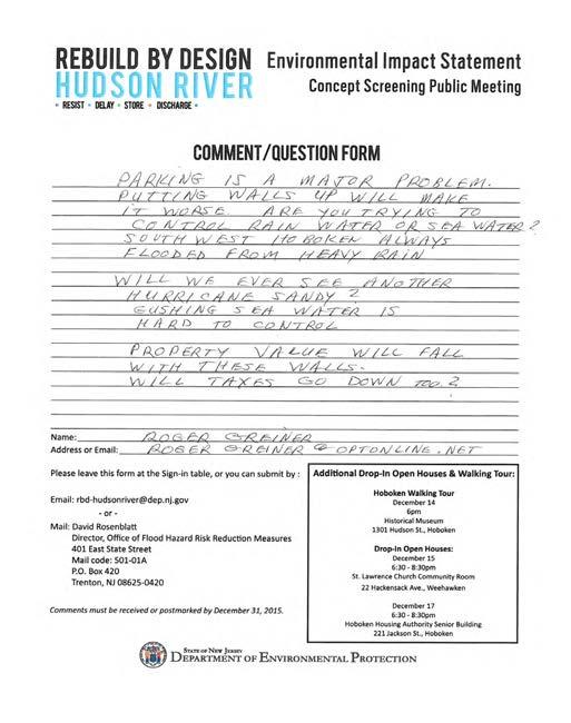

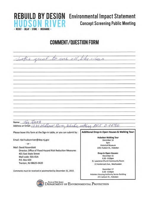


104 C-104 Appendix C: Public Comments


105 C-105 Appendix C: Public Comments


106 C-106 Appendix C: Public Comments

107 Doss, Gary From: Sent: To: Subject: Smith, Lawrence Wednesday, February 17, :36 AM Doss, Gary FW: Lawrence I. Smith PP, AICP Senior Planner Dewberry 600 Parsippany Road, Suite 301 Parsippany, New Jersey fax From: DEP rbd-hudsonriver Sent: Wednesday, February 17, :18 AM To: Smith, Lawrence Subject: From: Anne Lockwood Sent: Thursday, December 31, :45 PM Cc: Sean R. Kelly Subject: Comments regarding RBD impact in Hoboken Dear David Rosenblatt, Thank you for your presentations to our Hoboken community. I attended the excellent December 10th presentation at Wallace School, and the difficult gathering at the Museum on the 14th. Regarding the specific concepts presented for RESIST, we think Concepts A, C and D should be eliminated from consideration. Eliminate Concept A because of the serious community concerns expressed regarding flood walls intruding into the residential neighborhood of upper Garden Street. Eliminate Concepts C and D because of their high construction costs, poor constructability, and poor maintenance and operation ratings. We think Concepts E and B should proceed with design development. Suggestion: To achieve greater resistance to flooding into neighborhoods due to coastal surge, can the concepts of culverts and/or canals in vulnerable areas be expanded and developed? That is, could Dewberry and DEP dramatically expand the use of the water storage tanks that are already represented in the DELAY, STORAGE and DISCHARGE concepts to include more redirection of incoming surge waters via canals and/or culverts? We have all been watching the terrible images of the flooding in the UK and in the US midwest. Walls, berms and barriers seem to have limited success without tremendous redirection of waters. Thank you for your consideration. Anne Lockwood and Sean Kelly 1027 Garden Street David Rosenblatt, Director NJDEP Office of Flood Hazard Risk Reduction Measures 401 East State Street Mail Code A P.O. Box 420 Trenton, NJ December 3, 2015 RE: Comments on Delay Store Discharge & the Resist 5 concepts for Hudson River RBD Submitted via to rbd-hudsonriver@dep.nj.gov Dear Mr. Rosenblatt: My apologies, but I am not available to attend tonight s CAG meeting; thus, I am providing my comments in this letter. Delay Store Discharge Are we doing enough to address the Delay Store Discharge portion of this RBD project? Storing 250,000 gallons does not sound like much. Even adding the BASF site and SW Parks would likely have a minimal impact given a major storm like an Irene (flash flooding) or Sandy (surge). Have the following sites been considered for additional storage: the Long Slip Canal, the NJ Transit/Light Rail property in Jersey City north of 18th Street, and parks/reservoirs in Jersey City, Union City or Weehawken above the Palisades Cliffs? What about requiring major development projects at the north and south ends of Hoboken to provide substantial underground storm-water storage? Was any consideration given for additional pumps or secondary storm-water/sewer treatment facilities? How much we invest in Delay Store Discharge vs. Resist depends in part on the likelihood of another Sandy surge event. Was it a once in a thousand year event as some scientific studies have found? Has the Hudson River RBD team made a determination as to the probability? Understanding this will help to made decisions about how much to invest in the respective strategies. Investing 90% of the funds to build seawalls and/or flood walls might not make sense if it was an exceedingly rare event. Building walls that have a life of 50 years have a limited value if we are talking about a 500-year storm. This also raises the issue of maintaining the seawall/flood wall structures. Resist Concept A & Concept B Concept A s flood wall for north Hoboken is clearly the best option, as made manifest by last week s tour. This wall running along Park Avenue and then to Garden Street would provide excellent protection against a surge for the Shades in Weehawken and north Hoboken. It will gain widespread acceptance in the community compared to the other options. High walls along the waterfront walkway at the Hudson Tea Building, Hoboken Shipyards and Maxwell Place are likely to meet fierce resistance from residents and owners. At minimum DFE, the wall could be 8 to 12 feet high. Thus at street level and from ground-floor retail/residential views to the river and New York City skyline would be completely blocked. These views are an invaluable asset and add greatly to the value of these properties. Being able to enjoy the view from the top of a T wall would not be sufficient to overcome the opposition to such an idea. As pointed out during the tour, there are also problems, perhaps insurmountable, in getting property owners to agree to build such a wall. The flood walls at the south end of town for Concept A & B are problematic. The Hoboken Railyard Redevelopment area is slated for 2.3 million square feet of commercial and residential development on a ten-acre site south of Observer Highway and Hudson Place at the south end of Hoboken. The Hoboken City Council approved this redevelopment plan a year ago in December To place a flood wall abutting the southern portion of Observer Highway would conflict with the City s planned development on this NJ Transit property. It would also require multiple deployable gates where the north-south streets intersect the site. It is certainly reasonable to expect private developers/owners who build at the water s edge to provide adequate flood-proofing for their properties. This, of course, would be needed with Concept A at north Hoboken/Weehawken. New development needs to be built to a safe elevation. The code in Hoboken now requires this. I don t know about Jersey City, but the massive project to be built in Jersey City s Newport, south of the Long Slip Canal must meet that standard. The project would be provided additional protection by setting the buildings back from the water s edge, creating a waterfront walkway/bulkhead/seawall facing the water at a safe elevation, and elevating the upland area behind. (See model below.) Concept E The flood wall along the southern border of the Hoboken Railyard Redevelopment Area appears to be viable but it is not clear to me how it would work at either end. To the west, it appears that a surge would be directed toward Marin Blvd. and south Hoboken -- how would it be blocked? And what about the wall extending north (along Washington Street?) -- how would that work and how high it would be? If this is to be one of the alternatives, it would be good to do a tour of the south end of town. I assume the red line at the South Waterfront depicts a deployable flood wall. I think you should consider extending it another block south to include the Post Office Redevelopment site which is currently being planned by the City of Hoboken. I hope that this is helpful. If you have any questions regarding my comments, do not hesitate to contact me. Sincerely yours, Jersey City s Newport north project slated for development south of Long Slip Canal. The legends for the various concepts are difficult to read. It is difficult to distinguish the red from the purple, pink, etc. For instance, is the red a T wall, a raised path or a flood wall? Ron Hine Executive Director Resist Concept C & D Is the Hoboken Terminal seawall extending out into the Hudson River cost prohibitive? Does it raise permitting issues? Would NJ Transit be responsible for its maintenance? I understand that NJ Transit is working on flood-proofing the terminal which makes sense, especially given the difficulty of providing a seawall or flood wall to protect it. I believe the seawall/flood wall south of the Terminal makes sense at this location to prevent a surge from entering Hoboken at the South end of town. But it does raise the issue of what the impact will be to Newport in Jersey City. What about extending this seawall to the south along the riverfront and tying into an elevated Newport north site? For Concept C, the 1st Street label is incorrect. The image shown is the 4th Street area. 3 C-107 Appendix C: Public Comments
 and a Notice of Intent (NOI) was published in the Federal Register on September 4, 2015 (80 FR 53555).")
108 Scoping document responses September 4 - October 9, 2015 Scoping Document Response to Comments The Public Scoping Document was published/presented on the project website ( nj.gov) and a Notice of Intent (NOI) was published in the Federal Register on September 4, 2015 (80 FR 53555). The Public Comment Period began that day (September 4, 2015) and concluded on October 9, Scoping materials were presented to the Citizen Advisory Groups (CAG) on September 9, 2015 and October 8, A Public Scoping Meeting was held on September 24, 2015 where material was presented to the community. Two drop-in public sessions were also held on September 29, 2015 and October 1, 2015 for additional comment opportunities. Comments were received at all of these meetings as well as through the US mail. Additionally, comments were accepted through electronic mail throughout the comment period. Below are response to comments received during the comment period. Not all comments are listed below; however, all comments received have been reviewed and considered. Where possible, comments below have been aggregated in order to assist the reader in understanding the major areas of interest and/or concern resulting from the Scoping process. The original comment number is indicated by bold font and italics (20) following the paraphrased comment in this response document. Original comments in their entirety can be found in the table in Appendix X and following attachments. Comments that have been noted without additional response have been designated with an asterisk (*) next to the comment number in the table (Appendix B). Comments can be found in Appendix C. Scoping Document General Comments Comment: Define "Scoping" and provide an alternate word (1) Response: Scoping is a regulatory term which is defined in the Council on Environmental Quality National environmental Policy Act regulations at 40 CFR as an early and open process for determining the scope of issues to be addressed and for identifying the significant issues related to a proposed action. Comment: Please provide links for the documents used as references in the Scoping Document (2) Response: Hyperlinks have been provided in the reference section of the Final Scoping Document. approaches as well as important habitat corridors connecting the Hudson River ecosystem to the Palisades for threatened species such as Monarch Butterflies as well as critical ecosystem residents such as honeybees and pollinators. The project Scope should consider the possibility of converting a street into linear stormwater cachement device such as a Canal or large swale. This linear intervention could flow with tidal water from the Hudson River, or be aligned, designed, and engineered to collect stormwater from areas that are known to suffer surface flooding. The project Scope should consider creating any possible financial tools such as grants, revolving loan funds or other tools that could a) help to leverage additional public funds and or b) create public benefits on presently privately owned land through other tools such as deed restrictions, easements, or restrictive covenenants. Thank you for your consideration. Carter Craft 608 Garden Street Hoboken NJ Mr. Rosenblatt, I have been following the RBD Hudson River Project and had a question that I hope you can answer. The proposed project has the Resist component to reduce flooding by using a combination of hardened infrastructure, such as bulkheads, seawalls, and flood walls. I would like to know who will be engineering these structures. Do you have a list of engineering firms that you could provide me that are working on the project? My company has an extensive record in providing structural products for State, Federal and Local infrastructure projects to resist shoreline erosion (bulkheads, seawalls, groins) and flood mitigation (levees, floodwalls). We have worked with many of the agencies listed in the proposal like the NJDEP, USACE, USFW and many others. Besides the applications I mentioned above, we also provide water access solutions that allow the local community to enjoy their waterfront. I believe we Crane Materials International can provide great value to the RBD Hudson River project by supplying sustainable, high performance, long life cycle, and low cost product for the project. I would greatly appreciate your assistance in finding the correct parties to contact. I hope that you can help point me in the right direction. For more information about our offerings, please visit the following links to our websites. Comment: Comment on all maps - no sources? (142) Response: A subsection has been added to the document s reference section providing original data sources and methodology for developing mapping in the Final Scoping Document. Comment: Make sure acronyms being used are defined first. Applies to both written material and presentations. (6 and 17) Response: A list of acronyms is provided immediately following the table of contents on page iii of the Scoping Document. Comment: The executive summary should be simplified and provide the reader with an understanding of what the scoping document will present. This includes a brief background (the impacts from Sandy, recurring flooding issues within the project area, the uncertainty of future flood events) which establishes the need for the project. The executive summary should also state the purpose of the project and the four project strategies (RESIST, DELAY, STORE, DISCHARGE). The executive summary should help the reader understand how the feasibility study and EIS will analyze alternatives and produce a preferred alternative based upon screening criteria. Part of the narrative uses language that sounds like the intent of this project is to prevent consequences similar to Sandy- when the objective of the project is better expressed in reducing flood risk to a yet to be specified level of protection. In places, the language used to summarize the project is difficult to understand. Perhaps an improved summary might be: The Project is a comprehensive urban water strategy to reduce flood hazard and flood-related public health risks while leveraging infrastructure investments to enhance urban livability. Amending the preceding sentence should occur throughout the document. (94) Civil Infrastructure Bulkheads and Seawalls: Flood Protection: Waterfront Access Thank you. I look forward to hearing from you. Regards, Dave Trzeciak Regional Sales Manager Crane Materials International Direct: Cell: cmilc.com Rebuild by Design Hudson River: Resist Delay Store Discharge Appendix C - Comments C4 C-108 Appendix C: Public Comments

109 October 7, 2015 Mr. David Rosenblatt, Director Office of Flood Hazard Risk Reduction Measures 401 East State Street, Mail Code A, PO Box 420, Trenton, NJ Via Dear. Mr. Rosenblatt, On behalf of the Hoboken Community Advisory group for the Rebuild By Design Hudson River Project we submit the following comments on the draft Scope of Work for the EIS. Presentation of Initial Concepts/ p. 15 We believe that the "Resist" component should not be the exclusive focus of initial concepts, and attention should also be provided to the other components of the RBD plan, which address protecting Hoboken from other flood related threats as well. In taking this position we have consulted with staff at US HUD who have advised us that the funding can be spent for a more comprehensive flood protection solution. We therefore advise the Consultant team, who have tasked us as a CAG, to represent a wide cross section of the community, to instead look at each element of the Resist, Delay, Store and Discharge as viable and acceptable elements of the project. Purpose and Need/ p.7 The project goal should be to develop a comprehensive flood protection plan designed to address the risks from chronic tidal/high tide flooding, 500-year rainfall events, as well as periodic storm surge events. This analysis should consider the independent as well as interrelated risks of some of these conditions occurring at the same time, and over a period of time. Purpose(s): Reduce or Eliminate Need for Participation in NFIP Flood Insurance program/ p. 2 For instance, at a recent Climate Week event hosted by the Bank of America, the Deputy Director of Research on Climate for the White House announced that what we as society have long thought of as a 5-year storm is now more of a 3- or 4-year storm. Planning for this Hudson River project should incorporate these more conservative projections into the project framework. Explore Additional Co-Benefits/ p.3 The process should more clearly articulate and quantify what co-benefits a flood control process like this can help achieve such as improved mobility and improved air quality, expansion of non-vehicular transport by creating additional greenways, improved environmental quality through creation of green corridors with swales, engineered tree pits and more robust and thoughtful tree canopy, increased reliability of the electrical grid, improved public facilities such as upgraded water treatment plants, sewer lines, storage or containment tanks, pump stations, or improved public buildings that can serve dual purposes of shelters or others functional in emergency response or recovery. Goals and Objectives: Plan for a More Regional approach/ pp One of the goals of the project should be to protect the regional assets including existing and proposed mass transportation facilities (lines, terminal, station, and support facilities), water supply and sewage treatment, communications, and energy distribution in the project area. Goals and Objectives: Protect Vulnerable People/ pp We believe a more explicit goal should be to protect, secure and potentially improve lower and middle income housing stock, as well as other steps that can potentially reduce the vulnerability of the population that can be deemed "at risk." Defining and Quantifying our Goals for Water Management/ p The Scope should more clearly define the standards or goals we are trying to reach: xx inches of rain per yy hours sustained over 24 hours? ZZ feet of storm surge or flood tide? Perhaps the April 2007 rainstorm was more typical than the October 2012 storm We agree a goal of the project should be to improve the Community Rating for these areas in the FEMA framework in order to reduce the burden of costs for paying into the National Flood Insurance Program. The project should further consider the opportunity if not necessity for redirecting some portion of these funds into operations and maintenance of any resultant infrastructure from the various Build scenarios. Specify what Climate Scenario(s) we are Considering/ p.3 The Scope proposes to "consider impacts from climate change." Toward this end the Scope should acknowledge, identify, and plan for a specific sea level rise forecast such as one in use by the Intergovernmental panel on Climate Change and or the White House Climate Office. Screening Criteria and Cumulative Impacts: Coordination and, Where Possible, Integration/ p. 17, p. 35 The process, including the Screening Criteria and Evaluation Methodology, needs to be coordinated and considered with other plans such as those being developed by NJ Transit, (particularly the Long Slip Canal project given that this $150M project has the potential to mitigate flooding effects if coordinated as a resiliency strategy as part of this plan.) North Hudson Sewerage Authority (any long range Capital or Control plans), PSE&G (Energy Strong or other plans for the project area, the Port Authority (PATH train, vehicle tunnels, ventilators, command centers or other structures), the City of Hoboken (Green Infrastructure Strategic Plan), as well as plans for Jersey City, Weehawken, Hudson County (Park or Willow Avenue Bridges, Observer Highway, Marin Blvd or Grove Street underpasses), or other plans of Key Stakeholders. In addition, specific focus should be given to the interconnections between this project and the North Hudson Sewerage Authority s long term control plan (LTCP). The combinations of water quality and quantity issues are systemic along urban coastal waterfronts, and the scoping document should speak to strategies and implementable goals and objectives that are consistent with the LTCP. The aquatic area of Hoboken Cove and Weehawken Cove is known for poor water quality and little circulation. Therefore this area might be an appropriate place to focus. It will be useful for the project team to review the Water Quality Data at this location and three other locations in Hoboken at the NYC Water Trail site. There are results of tests from 20 weeks of sampling in 2015, and we also have the ability to access data here going 2-3 years back. Urban Design and Community co-benefits: Consider the Widest Range of Publicly Owned or Controlled Land for Potential Implementation/ p. 17 The Scope should consider proposed flood defenses and water management interventions across the range of public funded, owned or controlled land and rights of way in the project area including Hoboken Housing Authority, NJT Light Rail right of way, Hoboken Terminal and Yards, Hudson County Roads, Hoboken City Parks, Hudson County Parks, Hoboken Board of Education land and buildings (such as the playground at 11 th and Willow), as well as any area that has been a recipient of capital funding from local, state, and federal sources. Screening Criteria/ Identify Near-Term and Scalable Opportunities/ p. 17 The project scope should consider possibilities for allocating a portion of funds for nearterm pilot projects at a variety of scales that, over the next decade or more, have the potential to be scaled up or applied across a broader area as new opportunities emerge. Alternatives Analysis: Policy, Financial, Legal, Organizational and Operational Mechanisms that can Facilitate Implementation/ p. 19 As part of the Scope of Work the project should identify needed mechanisms for implementation, operations, and maintenance so as to most realistically ensure an ongoing state of good repair for any resultant infrastructure. This is especially important for those areas where the desired level of flood defense or water management cannot be adequately achieved in the public right of way alone. These mechanisms could include easements, restrictive covenants, or mechanisms such as PPPs, Associations, or "Improvement" "Resilience" or other "Water Management" districts. This could also include consideration of potential credits for property owners who undertake green infrastructure, water capture/ detention projects on their site. For the overall plan to succeed there must be clear steps and alternatives to help bridge the gaps where public and private lands intersect. Hazardous Waste/ p. 23 As part of the scope of work the project team should conduct a reasonable number of soil samples and tests in order to assess and verify potential levels of contamination. These should be focused particularly in areas that might be impacted as part of any build scenario. Data, Infrastructure and Utilities: Develop a Strong and Thorough Baseline Data Set/ p. 25, p. 32, p.33 The Draft Scope is flawed by failing to identify the available information on the current sewage and storm water management system in the area. For a project involving this large amount of money, focused on such a small geographic area, where the urban fabric is both dense and relatively old, any resultant Alternative must be based on a strong understanding of the existing system. Given the lack of understanding of many people, including residents and ratepayers, as to the myriad causes of the Sandy storm surge flood, it should be a clearly stated priority for Data Collection in any EIS for the project. People know the surge brought a huge volume of water, but many people also saw the water coming up through drains both inside and outside homes, not simply water coming down the street. In addition, verifying, and refining this baseline data is fundamental for the due diligence that is needed for any Build alternative to be potentially moved forward towards inclusion in a Record of Decision. This data should include: the capacity of the present storm water and combined sewer system, from the connections emanating from our businesses and households, corner drains, sewer pipes, all the way to the pump stations, treatment plant, and outfalls. a reasonable and responsible level of consideration must be given to the i. design capacity, ii. the age and physical integrity iii. and the actual operating capacity of the elements of the system. There is widespread anecdotal belief that many sewer lines are clogged or have other issues that limits their actual capacity to accomplish their task. This data must be made available to the public and interested stakeholders within a reasonable amount of time so that the evaluation of alternatives becomes a more transparent and comprehensible process. Data Collection/ Data Gathering Requires "Ground Truthing"/ p. 25 The actual causes of the Sandy flood are not widely understood within the population of the project area. Did the flood waters come purely from overland flow across the surface topography? Were flood waters facilitated or propagated through the sewer system? Was there any role played by basement drains or other old pipes under the streets that may not recognized and accepted on any current basemap? As part of the due diligence, the planning team should conduct surveys in a reasonable number of blocks across the study area. As part of this survey the design team should seek to identify and verify: known connections into the sewer system any un-mapped or presently unknown connections percent of the customer's land or surface area that is impervious, is designed to allow or has the potential to allow for water infiltration In addition, the due diligence for this project should include a reasonable number of subsurface sonar investigations (perhaps focused in flood prone areas) to help identify underground voids, collapsed pipes or potentially historic/old pipes that are not on any of the maps currently in use or available to the public. Infrastructure/ Need to Consider Public Buildings and Public Spaces/ p.32 In the consideration of items under infrastructure, the EIS process should consider the potential impacts as well as potential benefits from the use, improvement, adaptation or other physical modification to public buildings and to public spaces such as parks, parking garages or lots, or community facilities or sites identified in the City s various plans or by Municipal Resolution for development for these purposes. The fact these areas may provide important benefits, co-benefits, and be in the public domain suggest they may potentially help advance the project goals than simply walls at the waterfront. Indirect and Cumulative Impacts/ p. 35 As part of the analysis of potential alternatives the Financial and Cost models should include a higher escalation cost for the waterfront and in-water work than for the land-based work. In addition, if there are seasonal restrictions on when this work can be done, such as due to nesting, breeding, or migration of aquatic life, then this should be factored into the Cost Estimations as well. Thank you for the opportunity to provide this input into this very important project. We hope you and your team will make every effort to incorporate these perspectives. With such an ambitious schedule for this planning and evaluation we hope you will continue to provide additional opportunities for public input beyond the limited number of CAG meetings we have remaining. With best regards, Ravi Bhalla Carter Craft LaTrenda Ross CAG Co-Chairs Hoboken Wetland Project Canals and Wetlands Joan Abel C-109 Appendix C: Public Comments

110 2009 J. Abel 2009 J. Abel Culverted Harsimus Mill Creek Jersey City Filled land, formerly a cove of the Hudson River estuary Railroad tracks create a dyke From Douglass map 1841 Culverted creek from the Heights Culverted Hoboken Creek Former estuararine marsh Hoboken 2009 J. Abel Sites for Constructed Wetlands 2009 J. Abel Weehawken City border follows former creek Hoboken Perimeter Canal Site for Constructed Wetland Site for soft shoreline J. Abel 2009 J. Abel 2009 J. Abel 2009 J. Abel 2009 J. Abel 2009 J. Abel 2009 J. Abel Aerial view generat ed by the Manahatta Project staff at the Wildlife Conservation Society The Palisades Weehawken Cove Castle Point 2009 J. Abel 2009 Joan Abel, MES, B.Arch. 107 Monroe St. Hoboken, NJ Abeldesign2000@yahoo.com Have you forgotten that this place you live in is an estuarial marsh? These lands acted as sponges by soaking up rainwater and filtering pollutants before the water entered the Hudson River estuary. Large areas of Hoboken were originally tidal wetlands, rich spawning ground for all types of aquatic life. This proposal for environmentally sensitive solutions to flooding will present an overview the natural functioning of Hoboken s ecosystem, the history of human impact on the land and waterways, and will suggest ideas for alleviating flooding by restoring some integrity to our land. Wetland restoration involves changing the hydrology, elevation, soils, and/or plant community of a currently degraded wetland or a former wetland. And by restoring these areas Hoboken natives will enjoy an enhanced daily urban quality of life with recreation, beauty of landscape, historic and ecological memory, and educational opportunities right here at our front doors. Hoboken Wetland Project Waterfront and Marshland c.1879 Hoboken was once an island at high tide. Imagining an ecosystem restoration to alleviate flooding requires not only defining the problem, but also understanding the underlying natural history. Techniques of historical ecology and examination of old maps, surveys and other documents reveals some sense of the past natural waterways of the city. Hoboken Wetland Project 100 year flood This is the current configuration of high ground in Hoboken. A major storm event such as the mega-hurricane that s predicted regularly that arrived with Sandy in October 2012 and the city that we know and love will once again become an actual island. The sewers in Hoboken have to be big enough to cope with the amount of water that falls during extreme storm events. As more and more surfaces in the built-up areas are made impermeable, less and less water can percolate naturally into the soil. This means that the sewers get higher and higher loads. In Hoboken, we struggle with a combined sewer system. Wastewater from the household sinks, toilets, washing machines, etc. empties directly into the main sewer lines that also collect rainwater from the streets and rooftops. Each time we suffer from failure of the sewers to carry off rainwater we debate about the causes. Obviously, a number of conditions are allowing the streets to become lakes and rivers of human waste and toxic chemicals. Imagining an ecosystem restoration to alleviate flooding requires not only defining the problem, but also understanding the underlying natural history. The former natural features that are now considered environmentally critical areas include a former stream from the Heights now culverted below the streets, and all of the western portions of town that were formerly salt marsh wetlands. Hoboken Wetland Project Historic Natural Water Features Our city struggles with the effects of ever-increasing impervious areas. Here s an 1841 image of the earlier city with planned streets overlaid on the south cove. Note that the railroad trestle has created high ground at the south end of town, effectively creating a dyke that prevents water from seeking its natural outlet The city can install retrofits to improve existing stormwater infrastructure. The North Hudson Sewerage Authority has installed a wet weather pump station in the southeastern section of the city on Observer Highway. They are claiming an alleviation of the flooding problem in this section of Hoboken. The real goal should be not just to get approval for a development project or secure a stormwater permit, but rather to create a solution that will look good, perform well for many decades, and have a reasonable maintenance burden. Much of Hoboken started as a tidal wetland with a creek meandering through the southwest part of town. Once generally viewed as land of little value and less use, wetlands were considered marginal and expendable. As a result, none of Hoboken s original wetlands remain intact. Surface streams also have been obliterated diverted into underground pipes and incorporated into the City s combined sewer system (CSS). Hoboken Wetland Project Constructed Wetlands Restored Creek Canals Tidal Marsh Restoration Here s an outline of a few blocks at the north of town. The City of Hoboken is considering redevelopment plans for this once lowlying, tidal marsh. I propose to link this site with the rest of the town Hoboken Wetland Project and create a network of waterways, canals, and ponds that will start to identify our city as the one of the best places to call home for all creatures, great and small Hoboken Wetland Project Hoboken Wetland Project SOME LOCATIONS FOR WETLANDS Hoboken Wetland Project Another lost opportunity for flood mitigation If Hoboken bites the bullet and decides to really solve the flooding problems a lot of thinking outside the box is going to be required. A series of canals can have a measurable positive impact by helping to capture rainwater and channeling it into ponds and into the Hudson River. Creating constructed wetlands will begin to return our wetlands to their original function: holding and cleaning stormwater runoff before it enters the ground and/or the river. 6 7 Site west of the Hoboken business center between Harrison and Marshall Streets. Site south of Second Street and east of the lite rail on Marshall Street. This site, adjacent to Second Street at Marshall Street, is slated for another 5-story residential building. Hoboken Wetland Project Hoboken Wetland Project Hoboken Wetland Project Constructed Wetland Site north of Second Street and east of the lite rail. Site at the north of Hoboken and south of the shades. Note the lite rail in the background. Infiltration basins or constructed wetlands can be used to reduce the impacts of increased runoff rates and remove pollutants contained in stormwater runoff. An infiltration basin is a shallow depression created by excavation or berming that captures stormwater and stores it until it can infiltrate into the soil. The principal advantages of infiltration basins are that they help restore the natural water balance of a site and they can be integrated into a site s landscaping or open space. Infiltration basins also provide for some groundwater recharge if the soil conditions permit. Constructed wetlands carry stormwater runoff from paved surfaces and allow the water to percolate through the soil while providing habitat for wildlife such as birds and fish. Hoboken Wetland Project Original Shoreline This image developed by the Nature Conservancy is a clear picture of the west shoreline of the Hudson River as it had been in Amsterdam in the Netherlands... South walk at Liberty State Park... Like Hoboken, these areas have been built on marshes. Can our town look like this? I say YES Rebuild by Design Hudson River: Resist Delay Store Discharge Appendix C - Comments C16 Rebuild by Design Hudson River: Resist Delay Store Discharge Appendix C - Comments C17 Rebuild by Design Hudson River: Resist Delay Store Discharge Appendix C - Comments C18 Rebuild by Design Hudson River: Resist Delay Store Discharge Appendix C - Comments C19 David Rosenblatt Director, Office of Flood Hazard Risk Reduction Measures Department of Environmental Protection State of New Jersey Dear Mr. Rosenblatt: It is much appreciate that your offices are managing the Hudson River portion of Rebuild By Design. The public meeting at Hoboken's Multi-Service Center conducted by Dewberry Engineering last month speaks well of the entire team. Joan Abel, my wife, would have been a great asset in helping develop the environmental impact statement and in other matters related to this important work. Having a degree in architecture from Pratt and a masters in environmental studies from UPenn, Rebuild By Design was right up her alley. Sadly, she is no longer here to participate. Joan died last May, but in 2009 she published a brochure related to flooding in Hoboken and put forward bold ideas as to how it might be mitigated. You will find it attached. It is my hope that this provides information and insights valuable to the study. In this way, she is continuing her participation. Joan would be pleased. Sincerely, Jim Vance Note: as the executor of Ms. Abel's estate I wave any and all copyrights pertaining to this document. Please use it as you see fit. James Vance Hoboken Sweet Streets Making Streets Safe for Bicyclist & Pedestrians Hello, My comment to be included to the Scoping document can be found below. In the interest of the public, a budget outline should be provided for the administrative, material, and construction cost of the project. An itemized list be displayed on the Rebuild by Design website and ed to the Citizen Advisory Group for public access, providing the overall and estimated cost of the project. Thank you for your time. Best regards, Gregg Lanez Jersey City Environmental Commission EXECUTIVE SUMMARY The municipalities of Hoboken, Weehawken, and Jersey City were inundated by Superstorm Sandy coastal flood waters in October With half of Hoboken underwater for several days, emergency services were unavailable, residents were evacuated, and the National Guard was deployed to rescue those who could not evacuate. The magnitude of Sandy s devastation, primarily attributed to a recordbreaking storm surge during high tide, has somewhat dimmed the fact that little precipitation fell during that storm. Had matters been different, the Study Area s past history of flooding during heavy 2 rainfall events suggests that flooding levels and 3property damages could have been even higher. The Study Area (defined as the City of Hoboken, extending into Weehawken and Jersey City, with the following approximate boundaries: the Hudson River to the east; Baldwin Avenue [in Weehawken] to the north; the Palisades to the west; and 18th Street, Washington Boulevard and 14th Street [in Jersey City] to the south), is vulnerable to two interconnected types of flooding: 4coastal storm flooding (surge) and systemic inland flooding (rainfall) from medium (generally less than 5-year, 24-hour) to high (generally over 10-year, 5 24 hour) rainfall events that occur during periods of high tide. The flooding problems are attributed to several factors, including low topography and proximity to waterways; impervious coverage and surface runoff; existing 6relatively old sewer infrastructure, sewershed interconnections and insufficient 7 discharge capability particularly during high tide. As seen with Sandy, coastal storm flooding can devastate widespread areas of 8 the Study Area and cause significant economic damage and 9 safety concerns. In addition, systemic inland flooding associated with rainfall tends to be more localized to inland areas of lower elevation, but happens with much greater frequency than coastal surges. The systemic inland flooding typically occurs when high volumes of water are brought into the 10 storm-sewer system from medium to high rainfall events which coincide with an approaching 11 high tide and/or storm surge. During a high tide or storm surge, the water level of the Hudson River can rise above the level of the storm-sewer outflows; as a result, the river traps the water inside the storm-sewer system. Water then backs up within the system, flooding low-lying inland areas with storm and at times sanitary sewage. To address the region s flood and resiliency vulnerabilities, the United States Department of Housing and Urban Development (HUD) launched a Rebuild 12 by Design (RBD) competition inviting communities and designers to craft pioneering resiliency and flood damage prevention solutions. HUD awarded $230 million to the State of New Jersey for Phase 1 of the Hudson River Project: Resist, Delay, Store, Discharge project 13 (the Project) which seeks to reduce flooding and enhance resiliency in the municipality of Hoboken, and parts of Weehawken and Jersey City. The Project is a comprehensive 14 urban water strategy to reduce flood hazard and flood-related public health risks, which seeks to leverage resiliency investment to enhance 15 the urban condition. As stated in HUD s Federal Register (FR) notice 79 FR 62182, published October 16, 2014 [Docket No. FR-5696-N-11], the award is to assist in the funding of Phase 1 of the Project. Phase 1 includes the feasibility, design and environmental analysis of the entire comprehensive project, as well as funding for the implementation of the Resist component, to avert a repeat 16 of the widespread storm surge flooding that occurred during Sandy. The Project implementation strategy will recognize the need for a phased approach that will ultimately lead to a comprehensive flood damage prevention plan for the Study Area. The Project s award comes in the form of Community 17 Development Block Grant-Disaster Recovery (CDBG-DR) funding, which requires compliance with the National Environmental Policy Act (NEPA). Because of the Project s possible environmental impacts, NEPA requires the preparation of an Environmental Impact Statement (EIS). The Draft EIS will represent the culmination of the research and Rebuild by Design Hudson River: Resist Delay Store Discharge Appendix C - Comments C20 Rebuild by Design Hudson River: Resist Delay Store Discharge Appendix C - Comments C21 Rebuild by Design Hudson River: Resist Delay Store Discharge Scoping Document 1 C-110 Appendix C: Public Comments
111 Summary of Comments Page: 6 Number: 1 Author: jgonzalez Subject: Sticky Note Date: 9/7/ :17:09 PM Universal comment on executive summary and introduction - why isn't it called the "proposed project"? Number: 2 Author: jgonzalez Subject: Inserted Text Date: 9/7/2015 6:27:15 PM moderate to Number: 3 Author: jgonzalez Subject: Highlight Date: 9/7/2015 6:30:58 PM would suggest either leaving this vague as "damages" (which could include damages of all kinds) or more specific "property damages, impacts to quality of life, public and environmental health" -- either way, it wasn't just property damage. Number: 4 Author: jgonzalez Subject: Highlight Date: 9/7/2015 6:33:25 PM at some point we need to clearly differentiate the difference between high tide flooding and storm surge (Hoboken floods during high tides and precipitation events) - would be safer to say "tidal flooding" than coastal storm flooding. Maybe a glossary? Number: 5 Author: jgonzalez Subject: Inserted Text Date: 9/7/2015 6:33:03 PM greater than Number: 6 Author: jgonzalez Subject: Highlight Date: 9/7/2015 6:34:30 PM relative to what? would recommend replacing "relatively old" with "aging" Number: 7 Author: jgonzalez Subject: Sticky Note Date: 9/7/2015 6:36:55 PM There is a big point missing here about unknowns - we don't know exactly what the system capacity issues are and where; where the specific choke points are (I am personally hoping that H&H modeling done through this study will clearly identify the capacity and I&I issues) - this may be too much detail for this section, but needs to be addressed in the scoping document. Number: 8 Author: jgonzalez Subject: Inserted Text Date: 9/7/2015 6:37:54 PM Number: 9 Author: jgonzalez Subject: Inserted Text Date: 9/7/2015 6:38:04 PM, public health, Number: 10 Author: jgonzalez Subject: Highlight Date: 9/7/2015 6:40:02 PM combined stormwater - sewer system the CS issue hasn't been brought up clearly yet - needs to be discussed Number: 11 Author: jgonzalez Subject: Highlight Date: 9/7/2015 6:39:42 PM glad that this acknowledges they are different - but should be clearly discussed earlier Number: 12 Author: jgonzalez Subject: Inserted Text Date: 9/7/2015 9:59:05 PM the Number: 13 Author: jgonzalez Subject: Cross-Out Date: 9/7/2015 9:58:52 PM Number: 14 Author: jgonzalez Subject: Highlight Date: 9/7/ :23:52 PM I know this was an RBD phrase - but "urban water strategy" doesn't convey the fact that the goal is urban water management - seems like it's missing a key word Number: 15 Author: jgonzalez Subject: Highlight Date: 9/7/ :00:18 PM Need to define this earlier - or explain it here. Can this be replaced with the "urban quality of life"? Number: 16 Author: jgonzalez Subject: Highlight Date: 9/7/ :07:17 PM the way this is phrased sounds as though the goal is to prevent another Sandy - while that is the best case scenario, we don't know if it's possible until the feasibility study is complete - the document has not at this point stated that the design level is a Sandy event - is it 100 year, 500 year, or another design elevation? Number: 17 Author: jgonzalez Subject: Inserted Text Date: 9/7/ :07:45 PM HUD analysis conducted for this project and will clearly identify the impacts of each project alternative on the environment. 1 Public scoping is a necessary component of NEPA. As part of the public scoping process, this Draft Scoping Document has been prepared and submitted for public comment. This Draft Scoping Document outlines the Project s purpose and need, the proposed 2Project actions, as well as a description of areas of impact 3to be studied in the EIS. Once comments and input are received on the Draft Scoping Document from the public, 4the Final Scoping Document will be compiled. This will mark the beginning of the concept development and screening phase, which will invite input from the community and public stakeholders. The concept screening will lead to the selection of three Build Alternatives, which will then undergo further analysis and screening with additional community input. This screening process will then lead to the selection of the Preferred Alternative. The Draft EIS will be the culmination of this process. The Draft EIS will describe the alternatives analysis process, the public participation process, the affected natural as well as built environment, an evaluation of impacts and finally the selection of the Preferred Alternative. The Draft EIS will be made available to the general public for comment, as well as circulated to stakeholders, groups and government agencies that have been identified as having particular interest in the Project. A Notice of Availability will be published in the Federal Register and local media outlets at that time in accordance with HUD and Council on Environmental Quality (CEQ) regulations. After the required comment period has elapsed (a minimum of 45 days), we 5 will incorporate pertinent comments into the draft and compile the Final EIS. The Final EIS will be circulated in the same manner as the Draft EIS (including the publication of a Notice of Availability) and will have a comment period of 30 days. If, after the completion of the Final EIS comment period, no additional significant comments are received, the NJDEP will submit a 6Record of Decision (ROD) and Statement of Findings. The ROD designates the Preferred Alternative and identifies its environmental impacts and required mitigation measures. The Project is a comprehensive 7urban water strategy whose overall purpose is to reduce 8flood hazard risks, flood-related public health risks, and which seeks to leverage resiliency investment to enhance the urban 9 condition. The ability to meet this purpose will be measured in terms of: Contribute to Community Resiliency: The 10 Project will seek to integrate flood hazard risk reduction strategy with emergency, civic, and cultural assets (Hoboken s fire stations, hospitals, community centers, and transit centers). The Project will reduce 11 flood risks within the Study Area, leading to improved resiliency and the protection of accessibility and on-going operations of services (including protecting physical infrastructure such as hospitals, fire stations and police department buildings; and roadways and transit resources). 12 This 13 will allow these key assets to support emergency preparedness and community resiliency during and after flood events. Reduce Risks to Public Health: In addition to providing protection to critical healthcare infrastructure (such as local hospitals and emergency 14 preparedness services), the flood risk reduction strategy will aim to reduce the adverse health impacts that result from combined sewage backups onto streets, and within businesses and residences, through a reduction in 15 these types of flood events. Contributing 16 to On-going Community Efforts to Reduce FEMA Flood Insurance Rates: The City of Hoboken s exposure to flood risks has resulted in some of the highest insurance premiums in the state. The City has long had a goal of reducing those rates through a number of comprehensive flood risk reduction programs, such as those identified in the City s Green Infrastructure Plan. 17 The NFIP s Community Rating System (CRS) allows municipalities to reduce their flood insurance Rebuild by Design Hudson River: Resist Delay Store Discharge Scoping Document 2 October 9, 2015 Mr. David Rosenblatt, Director Office of Flood Hazard Risk Reduction Measures 401 East State Street, Mail Code A, PO Box 420, Trenton, NJ Via rbd-hudsonriver@dep.nj.gov re: Comments on Draft Scope of Work for Hudson River Rebuild By Design Project The project Scope should discourage in-water intervention and construction that might lead to increased siltation or reduced navigability in the Weehawken Cove area. The project Scope should consider re-use of land-based soil and sediment as well as dredge material from the Cove and area marinas such as Lincoln Harbor and the Shipyard and marine facilities. This material could be used for berms or other project elements where elevation changes to the landscape might be considered. Incorporating some land-based sediment in berms could enable for the development of additional and larger scale green infrastructure on land. The project Scope should evaluate potential air and other environmental impacts from creating a local sediment washing/ screening facility to enable this local reuse/ beneficial reuse. This facility could be based on land such as in the NJT Railroad yards or in water. Due to the fact that the Hudson River is a shared regional resource, the project Scope should recognize and consider the State of NY regulations as they seek to protect marine habitat and aquatic species. The resultant evaluation of alternatives should consider the fact that Washington Street is a large berm and focus the protective measures north of 14 th Street and south of Newark Street. Any protective measures / interventions recommended should be focused on low- and middle income housing, not market rate or luxury office buildings, apartments and hotels. The project Scope should consider the potential of creating green corridors linking existing open spaces such as: o Stevens Park to Church Square Park to Mama Johnson Field to the Palisades (along 4 th and 5 th Streets east-west) and o Elysian Park to Columbus Park to the Palisades (along 10 th Street) as well as o wide streets such as Grand Street (from Columbus Park to Observer rates through implementation of comprehensive floodplain management. The Project will propose concepts and alternatives that are consistent with Hoboken s overall effort of reducing FEMA Flood Insurance Rates. Delivery of Co-Benefits: 1 Where possible, the project will seek to integrate the flood hazard risk reduction strategy with civic, cultural and recreational values. The Project will look to incorporate active and passive recreational uses, multi-use facilities, and other design elements that integrate the Project into the fabric of the community. In this way, the Project will complement 2 local strategies for future growth. Connectivity to the Waterfront: The Study Area s waterfront is currently the location of a vast length of interconnected parks and public walkways which contribute to the vibrancy of the 3 community. The Project will aim to incorporate features that do not restrict access to the waterfront. t Where feasible, the Project will build 4 upon and enhance existing waterfront access points while still 5 providing flood risk reduction. Activation of Public Space: The project will develop concepts that reduce risks to private and public property from flood impacts while also incorporating design elements that activate public and recreational spaces, thereby enhancing 6quality of life for the community. Consider 7 Impacts from Climate Change: The project will take into account the projected impacts from climate change, particularly as it relates to sea level rise and its impacts on the frequency and degree of flooding. 2.0 INTRODUCTION Background The municipalities of Hoboken, Weehawken, and Jersey 9 City were inundated by flood waters during Superstorm Sandy in October With half of Hoboken flooded for several days, emergency services were unavailable, residents were evacuated, and the National Guard was deployed to rescue those who could not evacuate. The magnitude of Sandy s devastation, primarily attributed to a record-breaking storm surge during high tide, has somewhat dimmed the fact that little precipitation fell during that storm. Had matters been different, the Study Area s past history of flooding during heavy rainfall suggests that flooding levels and property damages could have been even higher. The Study Area (defined as the City of Hoboken, extending into Weehawken and Jersey City, with the following approximate boundaries: the Hudson River to the east; Baldwin Avenue [in Weehawken] to the north; the Palisades to the west; and 18th Street, Washington Boulevard and 14th Street [in Jersey City] to the south), is vulnerable to two interconnected types of flooding: coastal storm flooding (surge) and systemic inland flooding (rainfall) from medium (generally less than 5-year, 24-hour) to high (generally over 10-year, 24 hour) rainfall events that occur during periods of high tide. The flooding problems are attributed to several factors, including low topography and proximity to waterways; impervious coverage and surface runoff; existing relatively old sewer infrastructure, sewershed interconnections and insufficient discharge capability particularly during high tide. To address the region s flood and resiliency vulnerabilities, HUD launched the RBD competition inviting communities to craft pioneering resiliency solutions. A comprehensive urban water strategy was developed that included hard infrastructure and soft landscape for coastal defense (Resist), policy recommendations, guidelines and urban infrastructure to slow stormwater runoff (Delay), green and grey Rebuild by Design Hudson River: Resist Delay Store Discharge Scoping Document 3 Rebuild by Design Hudson River: Resist Delay Store Discharge Appendix C - Comments C25 Rebuild by Design Hudson River: Resist Delay Store Discharge Appendix C - Comments C26 Rebuild by Design Hudson River: Resist Delay Store Discharge Appendix C - Comments C27 October 9, 2015 Mr. David Rosenblatt, Director Office of Flood Hazard Risk Reduction Measures 401 East State Street, Mail Code A, PO Box 420, Trenton, NJ Via rbd-hudsonriver@dep.nj.gov re: Comments on Draft Scope of Work for Hudson River Rebuild By Design Project The project Scope should discourage in-water intervention and construction that might lead to increased siltation or reduced navigability in the Weehawken Cove area. The project Scope should consider re-use of land-based soil and sediment as well as dredge material from the Cove and area marinas such as Lincoln Harbor and the Shipyard and marine facilities. This material could be used for berms or other project elements where elevation changes to the landscape might be considered. Incorporating some land-based sediment in berms could enable for the development of additional and larger scale green infrastructure on land. The project Scope should evaluate potential air and other environmental impacts from creating a local sediment washing/ screening facility to enable this local reuse/ beneficial reuse. This facility could be based on land such as in the NJT Railroad yards or in water. Due to the fact that the Hudson River is a shared regional resource, the project Scope should recognize and consider the State of NY regulations as they seek to protect marine habitat and aquatic species. The resultant evaluation of alternatives should consider the fact that Washington Street is a large berm and focus the protective measures north of 14 th Street and south of Newark Street. Any protective measures / interventions recommended should be focused on low- and middle income housing, not market rate or luxury office buildings, apartments and hotels. The project Scope should consider the potential of creating green corridors linking existing open spaces such as: o Stevens Park to Church Square Park to Mama Johnson Field to the Palisades (along 4 th and 5 th Streets east-west) and o Elysian Park to Columbus Park to the Palisades (along 10 th Street) as well as o wide streets such as Grand Street (from Columbus Park to Observer rates through implementation of comprehensive floodplain management. The Project will propose concepts and alternatives that are consistent with Hoboken s overall effort of reducing FEMA Flood Insurance Rates. Delivery of Co-Benefits: 1 Where possible, the project will seek to integrate the flood hazard risk reduction strategy with civic, cultural and recreational values. The Project will look to incorporate active and passive recreational uses, multi-use facilities, and other design elements that integrate the Project into the fabric of the community. In this way, the Project will complement 2 local strategies for future growth. Connectivity to the Waterfront: The Study Area s waterfront is currently the location of a vast length of interconnected parks and public walkways which contribute to the vibrancy of the 3 community. The Project will aim to incorporate features that do not restrict access to the waterfront. t Where feasible, the Project will build 4 upon and enhance existing waterfront access points while still 5 providing flood risk reduction. Activation of Public Space: The project will develop concepts that reduce risks to private and public property from flood impacts while also incorporating design elements that activate public and recreational spaces, thereby enhancing 6quality of life for the community. Consider 7 Impacts from Climate Change: The project will take into account the projected impacts from climate change, particularly as it relates to sea level rise and its impacts on the frequency and degree of flooding. 2.0 INTRODUCTION Background The municipalities of Hoboken, Weehawken, and Jersey 9 City were inundated by flood waters during Superstorm Sandy in October With half of Hoboken flooded for several days, emergency services were unavailable, residents were evacuated, and the National Guard was deployed to rescue those who could not evacuate. The magnitude of Sandy s devastation, primarily attributed to a record-breaking storm surge during high tide, has somewhat dimmed the fact that little precipitation fell during that storm. Had matters been different, the Study Area s past history of flooding during heavy rainfall suggests that flooding levels and property damages could have been even higher. The Study Area (defined as the City of Hoboken, extending into Weehawken and Jersey City, with the following approximate boundaries: the Hudson River to the east; Baldwin Avenue [in Weehawken] to the north; the Palisades to the west; and 18th Street, Washington Boulevard and 14th Street [in Jersey City] to the south), is vulnerable to two interconnected types of flooding: coastal storm flooding (surge) and systemic inland flooding (rainfall) from medium (generally less than 5-year, 24-hour) to high (generally over 10-year, 24 hour) rainfall events that occur during periods of high tide. The flooding problems are attributed to several factors, including low topography and proximity to waterways; impervious coverage and surface runoff; existing relatively old sewer infrastructure, sewershed interconnections and insufficient discharge capability particularly during high tide. To address the region s flood and resiliency vulnerabilities, HUD launched the RBD competition inviting communities to craft pioneering resiliency solutions. A comprehensive urban water strategy was developed that included hard infrastructure and soft landscape for coastal defense (Resist), policy recommendations, guidelines and urban infrastructure to slow stormwater runoff (Delay), green and grey Page: 8 Number: 1 Author: jgonzalez Subject: Highlight Date: 9/7/ :42:10 PM Quality of life is a key co-benefit not mentioned here Number: 2 Author: jgonzalez Subject: Inserted Text Date: 9/7/ :43:18 PM seeks to Number: 3 Author: jgonzalez Subject: Sticky Note Date: 9/7/ :43:59 PM Insert reference to Hudson Waterfront Greenway? Number: 4 Author: jgonzalez Subject: Inserted Text Date: 9/7/ :44:15 PM seeks to Number: 5 Author: jgonzalez Subject: Cross-Out Date: 9/7/ :44:24 PM Number: 6 Author: jgonzalez Subject: Highlight Date: 9/7/ :46:25 PM should be referenced above? Number: 7 Author: jgonzalez Subject: Highlight Date: 9/7/ :47:07 PM consider impacts from is different than mitigating risk from, protecting against potential impacts from... Number: 8 Author: jgonzalez Subject: Highlight Date: 9/7/ :50:47 PM same comments as above Number: 9 Author: jgonzalez Subject: Inserted Text Date: 9/7/ :55:57 PM infrastructure improvements to allow for greater storage of excess rainwater (Store), and water pumps and alternative routes to support drainage (Discharge). The proposal was selected in the first round of RBD grants and HUD has awarded $230 million to the State of New Jersey for the Hudson River Project: Resist, Delay, Store, Discharge (the Project). As stated in HUD s Federal Register (FR) notice 79 FR 62182, published October 16, 2014 [Docket No. FR-5696-N-11], the award is to assist in the funding of Phase 1 of the Project. Phase 1 includes the feasibility, design and environmental analysis of the entire comprehensive project, as well as funding for the implementation of the Resist component. The RBD Competition delivered conceptual strategies. Those concepts must be further developed and evaluated for feasibility. Each of the concepts will be reviewed against on-the-ground, real world conditions to verify that the strategies can be built and that they will be effective. Because the need for solutions is urgent, the feasibility analysis for the Project will occur simultaneously with an environmental review. This will make the process more efficient and offer a faster route to implementation. 2.1 Regulatory Framework HUD s award comes in the form of CDBG-DR funds which require compliance with NEPA and its associated regulations as outlined in 24 CFR 58. When not otherwise accounted for by HUD s regulations, the Project is also subject to the CEQ NEPA regulations at 40 CFR 1parts HUD has further outlined the Project s environmental review compliance requirements in FR notice 79 FR 62182, published October 16, 2014 [Docket No. FR 5696 N 11]. The Project s compliance with the environmental laws and authorities as stated in HUD regulations (24 CFR 58.5 and 58.6), including compliance 2 with the National Historic Preservation Act (NHPA) of 1966, 3Floodplain Management and Wetland Protection Executive Orders (EOs) and 11990, Environmental Justice EO 12898, the Coastal Zone Management Act of 1972, and the Endangered Species Act of 1973 will also be demonstrated. The State of New Jersey, acting through the New Jersey Department of Community Affairs, 45 is the responsible entity that has assumed environmental responsibilities for the Sandy CDBG-DR programs in accordance with 24 CFR 58.1(b)(1). The New Jersey Department of Community Affairs has 6 designated NJDEP to assist with the environmental review. NJDEP will prepare the EIS in accordance with HUD s procedures for NEPA found at 24 CFR Part 58, et al. A Notice of Intent to prepare an EIS (as defined at 40 CFR ) was prepared in accordance with CEQ regulations, and represented the beginning of the public scoping process as outlined in 40 CFR The NOI was published on September 8, As part of the public scoping process, this Draft Scoping Document has been prepared and submitted for public comment. The Draft Scoping Document outlines in detail the proposed Project actions as well as a description of areas of impact to be studied in the Draft EIS. Once comments on the Draft Scoping Document have been compiled 7 from the public, the Final Scoping Document will be developed. This will mark the beginning of the concept development and screening phase, which will invite input from the community and public stakeholders. The concept screening will lead to the selection of three Build Alternatives, which will then undergo further analysis and screening with additional community input. This screening process will then lead to the selection of the Preferred Alternative. The Draft EIS will be the culmination of this process. The Draft EIS will be the culmination of this process. The Draft EIS will describe the alternatives analysis process, the public participation process, the affected natural as well as built environment, an evaluation of impacts and finally the selection of the Preferred Alternative. Upon completion, the Draft EIS will be and made available to the general public for comment, as well as circulated to stakeholders, groups and government agencies that have been identified as having particular interest in the Proposed Project. A Notice of Availability will be published in the Federal Register and local Rebuild by Design Hudson River: Resist Delay Store Discharge Appendix C - Comments C28 Rebuild by Design Hudson River: Resist Delay Store Discharge Scoping Document 3 Rebuild by Design Hudson River: Resist Delay Store Discharge Scoping Document 4 C-111 Appendix C: Public Comments

 Number: 5 Author: jgonzalez Subject: Inserted Text Date: 9/7/2015 11:03:22 PM Number: 6 Author: jgonzalez Subject: Inserted Text Date: 9/7/2015 11:03:33 PM NJDCA Number: 7 Author:")
, Dewberry will incorporate pertinent comments into the draft and compile the Final EIS.")
112 Page: 9 Number: 1 Author: jgonzalez Subject: Cross-Out Date: 9/7/ :07:24 PM remove (unless referring to "part" for all other regulations - e.g., 24 CFR part 58 - consistency) Number: 2 Author: jgonzalez Subject: Inserted Text Date: 9/7/ :59:27 PM but not limited to, (unless all laws, regulations and authorities in 58.5 and 58.6 are referenced in the following sections) Number: 3 Author: jgonzalez Subject: Inserted Text Date: 9/7/ :57:44 PM, as amended Number: 4 Author: jgonzalez Subject: Inserted Text Date: 9/7/ :03:27 PM (NJDCA) Number: 5 Author: jgonzalez Subject: Inserted Text Date: 9/7/ :03:22 PM Number: 6 Author: jgonzalez Subject: Inserted Text Date: 9/7/ :03:33 PM NJDCA Number: 7 Author: jgonzalez Subject: Sticky Note Date: 9/7/ :10:06 PM same comments as above media outlets at that time in accordance with HUD and Council on Environmental Quality (CEQ) regulations. After the required comment period has elapsed (a minimum of 45 days), Dewberry will incorporate pertinent comments into the draft and compile the Final EIS. The Final EIS will be circulated in the same manner as the Draft EIS (including the publication of a Notice of Availability) and will have a comment period of 30 days. If, after the completion of the Final EIS comment period, no additional significant comments are received, the NJDEP will submit a Record of Decision (ROD) and Statement of Findings. The ROD designates the Preferred Alternative and identifies its environmental impacts and required mitigation measures. Figure 1 Page: 10 Number: 1 Author: jgonzalez Subject: Sticky Note Date: 9/7/ :15:31 PM Comment on all maps - no sources? 2.2 Proposed Project The Proposed Project takes a multi-faceted approach intended to address flooding from 1both major storm surge and high tide as well as from heavy rainfall events. The Proposed Project 2will benefit flooding areas inside the Study Area, which encompasses 3 the City of Hoboken, extending into Weehawken and Jersey City, with the following approximate boundaries: the Hudson River to the east; Baldwin Avenue (in Weehawken) to the north; the Palisades to the west; and 18th Street, Washington Boulevard and 14th Street (in Jersey City) to the south (see Figure 1). The project s comprehensive approach to flood reduction and resiliency consists of four integrated components: 1. Resist: a combination of hard infrastructure (such as bulkheads, floodwalls and seawalls) and soft landscaping features (such as berms and/or levees which could be used as parks) that act as barriers along the coast during exceptionally high tide and/or storm surge events; 2. Delay: policy recommendations, guidelines and urban green infrastructure to slow stormwater runoff; 3. Store: green and grey infrastructure improvements, such as bioretention basins, swales, and green roofs, that slow down and capture stormwater, and which will complement the efforts of the City of Hoboken s existing Green Infrastructure Strategic Plan; and 4. Discharge: enhancements to Hoboken s existing stormwater management system, including the identification and upgrading of existing stormwater/sewer lines, outfalls and pumping stations. 1 While the funding allocation awarded in the CDBG-DR grant provides for the implementation of Phase 1 of the project, which includes the Resist component, the EIS and feasibility analysis will examine three Build Alternatives, as well as a No Action Alternative, for the entire comprehensive approach. Each of the three Build Alternatives will include elements of all four strategic project components: Resist, Delay, Store and Discharge. The three Build Alternatives will vary primarily by the Resist infrastructure s alignment and termination points. The possible Resist alignments will include: along the waterfront, in the water (in the Hudson River), and upland. The waterfront is defined as along the existing walkway/esplanade that runs along the eastern edge of the City of Hoboken and Township of Weehawken. The upland portion represents areas landward of the walkway/esplanade. The Resist structures 4will consist of a combination of multi-purpose levees, floodwalls and other features that 5will reduce the flood risk within the Project Area from future coastal 6storm surge events. In all three Build Alternatives, the Delay, Store, and Discharge, components will be located on the landward side of the Resist infrastructure and may consist of a combination of green infrastructure (bioswales, 7 storage basins and others) and grey infrastructure (pumps, 8 pipes and others). Below is an example of three possible Build Alternatives, as well as the No Action Alternative: Alternative 1 may analyze a Resist alignment that is constructed along a combination of in-water, waterfront, and upland locations and terminates at appropriate locations upland or on the waterfront. Alternative 2 may analyze a Resist alignment constructed primarily along the waterfront with termination points at appropriate upland or waterfront locations. Alternative 3 may analyze a Resist alignment primarily constructed upland with termination points located upland. The No Action Alternative, which represents no improvements, will also be evaluated as part of the EIS. Rebuild by Design Hudson River: Resist Delay Store Discharge Scoping Document 5 Rebuild by Design Hudson River: Resist Delay Store Discharge Scoping Document 6 Rebuild by Design Hudson River: Resist Delay Store Discharge Appendix C - Comments C32 Rebuild by Design Hudson River: Resist Delay Store Discharge Appendix C - Comments C33 Rebuild by Design Hudson River: Resist Delay Store Discharge Appendix C - Comments C34 Rebuild by Design Hudson River: Resist Delay Store Discharge Appendix C - Comments C35 Page: 11 Number: 1 Author: jgonzalez Subject: Highlight Date: 9/7/ :23:49 PM Good! Clarify that they can occur at the same time and exacerbate potential impacts? Number: 2 Author: jgonzalez Subject: Highlight Date: 9/7/ :24:21 PM seeks to Number: 3 Author: jgonzalez Subject: Cross-Out Date: 9/7/ :24:32 PM Number: 4 Author: jgonzalez Subject: Highlight Date: 9/7/ :38:18 PM May? Isn't the purpose of the feasibility study to determine the preferred alternative that will compose the project? Number: 5 Author: jgonzalez Subject: Highlight Date: 9/7/ :38:56 PM seek to Number: 6 Author: jgonzalez Subject: Highlight Date: 9/7/ :42:08 PM coastal storm surge or "tidal flooding" (to encompass high tide and storm surge flooding) Number: 7 Author: jgonzalez Subject: Inserted Text Date: 9/7/ :39:52 PM such as Number: 8 Author: jgonzalez Subject: Inserted Text Date: 9/7/ :39:47 PM such as The alternatives analysis within the EIS will consist of a comparison of the four alternatives impacts on the environment pursuant to 24 CFR Part 58, et al, as well as how well each alternative meets the Project s Purpose and Need. This process, which will be described in detail in the EIS, will lead to the recommendation of a Preferred Alternative. The Project will integrate with the goals and recommendations of existing municipal planning efforts, such as the 1City of Hoboken Green Infrastructure Strategic Plan (October 2013). This plan outlines Hoboken s approach to potential green infrastructure improvements throughout the City. The Project will build upon 2 the findings of this strategic plan and incorporate its recommendations wherever practical. al. The Project will look at other nearby independent projects that may benefit the Project s goals and objectives. The impacts of these projects, in conjunction with the impacts from this project, will be considered during the cumulative impacts analysis, and will be accounted for wherever practical during the concept and alternatives development phase. 3.0 Purpose and need 3.0 Purpose The Study Area, comprising the entire City of Hoboken, and adjacent areas of Weehawken and Jersey City (see Figure 1), is vulnerable to flooding from both coastal 3 storm surge and inland rainfall events. The purpose of the project is to reduce the flood risk to flooding areas within the Study Area. The Project intends to minimize the impacts from surge and 4 rainfall flood events on the community, including adverse impacts to public health, while providing benefits that will enhance the urban condition, 5recognizing the unique challenges that exist within a highly developed urban area. Page: 12 Number: 1 Author: jgonzalez Subject: Highlight Date: 9/7/ :43:45 PM Why is this referred to and no other ongoing City efforts? While I am of course a strong proponent of this plan, I would recommend either removing specific references to specific plans, or adding other City resiliency efforts. Number: 2 Author: jgonzalez Subject: Sticky Note Date: 9/7/ :44:04 PM Note Weehawken and Jersey City efforts? Number: 3 Author: jgonzalez Subject: Inserted Text Date: 9/7/ :44:37 PM high tide flooding, Number: 4 Author: jgonzalez Subject: Inserted Text Date: 9/7/ :45:09 PM tidal flooding Number: 5 Author: jgonzalez Subject: Inserted Text Date: 9/7/ :45:31 PM quality of life Number: 6 Author: jgonzalez Subject: Highlight Date: 9/7/ :47:17 PM to a point made previously - coastal flooding is not equal to storm surge flooding. Tidal Flooding can be high tide flooding and/or storm surge flooding. Number: 7 Author: jgonzalez Subject: Inserted Text Date: 9/7/ :47:32 PM greater than Number: 8 Author: jgonzalez Subject: Highlight Date: 9/7/ :48:30 PM Generally, but not entirely true - storm surge flooding occurs less frequently, high tide flooding occurs more regularly Number: 9 Author: jgonzalez Subject: Sticky Note Date: 9/7/ :48:51 PM see comments from executive summary were gradually filled in as the area grew. Today, 1 these areas in particular those to the west are still extremely low-lying, in some places no more than three feet above sea level. Figure Need The Study Area is a very dense urban area of Hudson County that is situated along the Hudson River directly west of Manhattan, New York. The Study Area is vulnerable to two interconnected types of flooding: 6coastal (surge) flooding from storm surge and high tide, as well as systemic inland (rainfall) flooding from medium (generally a 5-year, 24-hour) to high (generally over 10-year, 7 24 hour) rainfall events. 2 Coastal 8 flooding happens with much less frequency, but can devastate widespread areas of the Study Area and cause significant economic damage and safety concerns. Rainfall-induced flooding occurs with significantly greater frequency than coastal flooding, and is caused in large part by the characteristics of the Study Area s topography and land use patterns as well as the physical constraints of the existing North Hudson Sewerage Authority (NHSA) infrastructure. The flooding problems for both coastal flooding and rainfall-induced 9 flooding can be attributed to several factors, including low topography and proximity to waterways; impervious coverage and surface runoff; existing sewer infrastructure, sewershed interconnections and insufficient discharge capability particularly during high tide. The topography of the Study Area is highest along the east-central portion abutting the coastline of the Hudson River at Castle Point (see Figure 2). From here, the land slopes gently downward to the north (towards Weehawken Cove), south (towards the Hoboken Terminal and Jersey City) and to the west (towards the foot of the Palisades). This topography reflects the Study Area s history; when originally settled, Castle Point was an island surrounded to the north, south and west by wetlands. These wetlands Rebuild by Design Hudson River: Resist Delay Store Discharge Scoping Document 7 Currently, approximately 16,798 parcels (or, approximately acres of land and 66% of the overall Study Area) are within the Hudson River s one-percent (Zone AE/VE) or 0.2-percent (Zone X) annualchance floodplains (see Figure 3). The majority of the Study Area is within the AE flood zone, with base flood elevations (BFEs) of between 10 and 12 feet 3NAVD 88. Furthermore, the areas immediately adjacent to the coastline are within the VE zone (areas subject to the 0ne-percent-annual-chance 4 flood as well as storm-induced velocity wave action) with BFEs of between 16 and 17 feet NAVD 88. The VE zone typically does not extend beyond the streets and parks along the waterfront. Much of Hoboken s critical Rebuild by Design Hudson River: Resist Delay Store Discharge Appendix C - Comments C36 Rebuild by Design Hudson River: Resist Delay Store Discharge Appendix C - Comments C37 Rebuild by Design Hudson River: Resist Delay Store Discharge Scoping Document 8 C-112 Appendix C: Public Comments
113 Page: 13 Number: 1 Author: jgonzalez Subject: Inserted Text Date: 9/7/ :49:18 PM developed Number: 2 Author: jgonzalez Subject: Sticky Note Date: 9/7/ :49:40 PM missing sources Number: 3 Author: jgonzalez Subject: Highlight Date: 9/7/ :50:51 PM no space between NAVD88 (universal change) Number: 4 Author: jgonzalez Subject: Highlight Date: 9/7/ :51:20 PM looks like a zero fifth highest in New Jersey). In addition, the overall liability to the NFIP from property owners in Hoboken was over $2 billion (third highest in New Jersey) with an average claim amount of $26,243. The interrelationship between coastal flooding and rainfall events contributes to the recurring flooding conditions throughout the Study Area. Each component represents challenges and will need to be addressed comprehensively in order to reduce the flood risk within the Study Area Coastal Flooding The coastal communities of Hudson County have historically been vulnerable to coastal 1flood events. According to the 2 FEMA s Preliminary Flood Insurance Study of Hudson County, New Jersey (FEMA, 2013), the most severe flooding for the coastal communities of Hudson County occurs from tidal surges during hurricanes. Surge water is brought into the area from the Upper New York Bay, New York Bay and Kill Van Kull, where it is then driven by winds upriver along the Hackensack, Passaic and Hudson Rivers, eventually overflowing onto the shoreline communities. The duration of coastal surges can be increased if the storm also brings about high amounts of rainfall. For example, in 2011, Hurricane Irene brought a fivefoot storm surge to the Hudson River, flooding parts of Jersey City and Hoboken, along with 10 inches of rainfall. After the storm passed, flooding conditions remained because the vast amount of rainfall from the storm was draining through tributaries to the Hudson River, which was already swollen by the storm surge. The 3 coastal 4 surge can be further exacerbated if it coincides with a high tide. For example, a strong storm surge on the Hackensack River on November 25, 1950 resulted in flood waters of 6.5 feet (nine feet above the low tide level). If this surge had occurred during high tide, flood levels would have reached 12 feet. A situation like this occurred during Superstorm Sandy; the storm surge coincided with a full moon, which caused an abnormally high tide that was 20% above the normal high tide level. This factor significantly contributed to Sandy s devastating flooding of the Study Area. Superstorm Sandy exposed the vulnerabilities within the Study Area by flooding the coastal areas of Jersey City, Weehawken and Hoboken, as well as over two thirds of the City of Hoboken s low-lying interior areas. Surge waters flooded electric utility substations and transformers; power was not restored to many Jersey City and Hoboken residents for nearly two weeks. In addition, the surge flooded critical transportation infrastructure, including the Port Authority Trans Hudson (PATH) line at the Hoboken Terminal. Service on this line was not restored for several months. Studies conducted by the Stevens Institute of Technology Davidson Laboratory found that approximately 466 million gallons of water inundated the interior areas of Hoboken. The water entered at the lowest areas of elevation. Within the Study Area, there were two main entry points: the area around Long Slip Canal and Hoboken Terminal in the south of Hoboken, and Weehawken Cove in the north. In the south the surface elevation ranges between two and five feet above sea level in and around Warrington Plaza and the Hoboken Terminal. In the area around Weehawken Cove, the elevations range between six and seven feet above sea level. When these elevations are compared to the flood surge levels caused by Superstorm Sandy, the degree of flooding becomes apparent. Sandy brought approximately 11 feet of surge water into Warrington Plaza and Hoboken Terminal, resulting in flood waters of between six to nine feet above ground elevation. The southern and northern low-lying areas of the Study Area, along the Hudson River, acted as an inlet for flood waters into western Hoboken (see Figure 4). During Sandy, according to the Stevens Study, approximately 232 million gallons of water entered at the southern breach point, to the south of the Hoboken Terminal. Approximately 78 million gallons of this water remained within the NJ Transit rail yard, Page: 15 Number: 1 Author: jgonzalez Subject: Highlight Date: 9/8/2015 7:15:34 AM says 'flood events' but only talks about storm surge, not other instances of tidal flooding (high tide flooding) Number: 2 Author: jgonzalez Subject: Cross-Out Date: 9/8/ :03:40 AM Number: 3 Author: jgonzalez Subject: Cross-Out Date: 9/8/ :05:04 AM Number: 4 Author: jgonzalez Subject: Inserted Text Date: 9/8/ :05:21 AM C The ground elevation in western Hoboken is low-lying; the H1 sewershed (the southwestern area of Hoboken; see Figure 4) in particular is on average about three feet above sea level. This portion of the Study Area also happens to be home to many vulnerable communities; the H1 Sewershed is the location of several of the Hoboken Housing Authority s communities. Floodwaters were funneled in from the north and south, inundating this portion of Hoboken, as well as the western areas of the H4, H5 and H7 sewersheds. Because the surge prevented 1sewer outflow (the surge water elevation was above the outflow 2 level), the surge waters had nowhere to flow and persistent inland flooding resulted. In addition, because the surge prevented sewer outflow, domestic sanitary sewage backed up in residences and businesses, posing a significant public health risk. Overall, Superstorm Sandy caused approximately $100 million in damages to private property and $10 million to City-owned property in Hoboken. Notably, Hoboken University Medical Center (the only hospital within the Study Area, located in south-central Hoboken) received significant flood damage; the hospital was forced to evacuate all patients the day prior to the storm and was not able to fully reopen until November 14, over two weeks after the storm hit. In the interim, patients were redirected to other nearby hospitals many of which were also damaged by Sandy. As sea level is expected to rise, the associated base flood elevations along the Study Area s coastline will likewise increase, further compounding the risk of flooding. Storm surge and high tide will increasingly overtop the existing bulkheads, inundating the low-lying areas of the community. Studies have shown that in the mid-1800s, there was a 1% annual chance of a bulkhead being overtopped by a storm surge within the New York Harbor area; today there is a 20 to 25% annual chance (Blumberg et al, 2015). Rising sea level also means that the NHSA s 3outflows and other critical infrastructure will be closer to mean sea level. As the vertical distance between the elevation of the water and the elevation of the 4outflows decreases, less 5 intense storm surge (which happen with 6 greater frequency than stronger storms) will have the ability 7 to inundate the outflows, thereby reducing the ability of the system to properly drain storm waters. 8 This means that over time, coastal flood events are expected to occur with greater frequency Systemic Inland Flooding The NHSA, the 9agency that provides storm and sanitary sewer utility service to the Study Area, has a combined sewer system that was built in two periods, during the 1850 s and from the 1920s to the 1940s. The combined sewer system handles both sanitary sewerage as well as stormwater runoff. Hoboken is divided into seven main drainage areas (H1-H7, see Figure 4). 10 Sewerage is conveyed through the system by gravity from its source (e.g., a residence or business) through 11 storm-sewer mains beneath street beds to the system s main interceptor pipelines. During dry conditions, a system of pump stations located within the NHSA s service area pump the sewerage to the NHSA s Adam s Street Wastewater Treatment Plant (WWTP). This WWTP serves Hoboken, Weehawken and Union City. During rainstorms, stormwater 14 (i.e., rainfall runoff) flows into the 15 storm-sewer mains via street and curb inlets and combines with the sanitary sewerage. 16 If the storm-sewer flow volume exceeds the limited treatment volume capacity (between 32 and 36 million gallons per day) of the WWTP, a portion of the storm-sewer flow volume outflows into the Hudson River through the various outfalls located along Hoboken s waterfront. Inland flooding occurs when the storm-sewer system is unable to outflow excess water into the Hudson River. This typically occurs when high volumes of water are brought into the storm-sewer system from medium (generally a 5-year, 24-hour) to high (generally over 10-year, hour) rainfall events which coincide with a high tide and/or storm surge. Rainfall events of greater than two inches, combined with a high tide of four feet or greater, occurred 26 times in Hoboken from 2002 to This is expected to increase in frequency over time as sea levels rise; the National Oceanic and Atmospheric Administration (NOAA) estimates sea levels may rise from between 0.5 to 3.5 feet by the year As a result, high tides and storm surges are expected to block or obstruct the outfalls for increasingly longer periods of time. Rebuild by Design Hudson River: Resist Delay Store Discharge Scoping Document 10 Rebuild by Design Hudson River: Resist Delay Store Discharge Scoping Document 12 Rebuild by Design Hudson River: Resist Delay Store Discharge Appendix C - Comments C41 Rebuild by Design Hudson River: Resist Delay Store Discharge Appendix C - Comments C42 Rebuild by Design Hudson River: Resist Delay Store Discharge Appendix C - Comments C43 Page: 17 Number: 1 Author: jgonzalez Subject: Highlight Date: 9/8/2015 7:12:23 AM outflow from the combined sewer system Number: 2 Author: jgonzalez Subject: Highlight Date: 9/8/2015 7:12:07 AM outfall Number: 3 Author: jgonzalez Subject: Highlight Date: 9/8/2015 7:13:46 AM outfalls Number: 4 Author: jgonzalez Subject: Highlight Date: 9/8/2015 7:14:03 AM outfalls Number: 5 Author: jgonzalez Subject: Highlight Date: 9/8/2015 7:14:31 AM less intense "tidal flooding" Number: 6 Author: jgonzalez Subject: Inserted Text Date: 9/8/2015 7:14:13 AM s Number: 7 Author: jgonzalez Subject: Inserted Text Date: 9/8/2015 7:14:46 AM could Number: 8 Author: jgonzalez Subject: Cross-Out Date: 9/8/2015 7:14:54 AM Number: 9 Author: jgonzalez Subject: Highlight Date: 9/8/2015 7:16:01 AM utility Number: 10 Author: jgonzalez Subject: Highlight Date: 9/8/2015 7:16:26 AM Sewage Number: 11 Author: jgonzalez Subject: Highlight Date: 9/8/2015 7:16:58 AM combined stormwater-sewer mains Number: 12 Author: jgonzalez Subject: Highlight Date: 9/8/2015 7:17:19 AM sewage Number: 13 Author: jgonzalez Subject: Inserted Text Date: 9/8/2015 7:17:12 AM s Page: 18 Number: 1 Author: jgonzalez Subject: Highlight Date: 9/8/2015 7:20:40 AM outfalls Number: 2 Author: jgonzalez Subject: Cross-Out Date: 9/8/2015 8:03:45 AM Number: 3 Author: jgonzalez Subject: Sticky Note Date: 9/8/2015 7:23:37 AM What about the environment? quality of life? Number: 4 Author: jgonzalez Subject: Sticky Note Date: 9/8/2015 7:24:21 AM Same comments as above on this entire section improved resiliency and the protection of accessibility and on-going operations of services (including protecting physical infrastructure such as hospitals, fire stations and police department buildings; and roadways and transit resources). This will allow these key assets to support emergency preparedness and community resiliency during and after flood events. Reduce Risks to Public Health: In addition to providing protection to critical healthcare infrastructure (such as local hospitals and emergency preparedness services), the flood risk reduction strategy will aim to reduce the adverse health impacts that result from combined sewage backups onto streets, and within businesses and residences, through a reduction in these types of flood events. Contributing to On-going Community Efforts to Reduce FEMA Flood Insurance Rates: The City of Hoboken s exposure to flood risks has resulted in some of the highest insurance premiums in the state. The City has long had a goal of reducing those rates through a number of comprehensive flood risk reduction programs, such as those identified in the City s Green Infrastructure Plan. The NFIP s Community Rating System (CRS) allows municipalities to reduce their flood insurance rates through implementation of comprehensive floodplain management. The Project will propose concepts and alternatives that are consistent with Hoboken s overall effort of reducing FEMA Flood Insurance Rates. Delivery of co-benefits: Where possible, the project will seek to integrate the flood hazard risk reduction strategy with civic, cultural and recreational values. The Project will look to incorporate active and passive recreational uses, multi-use facilities, and other design elements that integrate the Project into the fabric of the community. In this way, the Project will complement local strategies for future growth. Page: 19 Number: 1 Author: jgonzalez Subject: Highlight Date: 9/8/2015 7:45:29 AM tidal flooding (or just storm surge)? Number: 14 Author: jgonzalez Subject: Highlight Date: 9/8/2015 7:17:49 AM shouldn't this be defined above, at the first instance? Number: 15 Author: jgonzalez Subject: Highlight Date: 9/8/2015 7:19:14 AM made several comments about changing this to combined sewer mains or combined sewer infrastructure, but alternatively you could use this phrase as long as it is defined (another case when a glossary at the beginning might help) Number: 16 Author: jgonzalez Subject: Highlight Date: 9/8/2015 7:18:09 AM sewage Number: 17 Author: jgonzalez Subject: Inserted Text Date: 9/8/2015 7:19:54 AM greater than Connectivity to the Waterfront: The Study Area s waterfront is currently the location of a vast length of interconnected parks and public walkways which contribute to the vibrancy of the community. The Project will aim to incorporate features that do not restrict access to the waterfront. Where feasible, the Project will build upon and enhance existing waterfront access points while still providing flood risk reduction. Activation of Public Space: The project will develop concepts that reduce risks to private and public property from flood impacts while also incorporating design elements that activate public and recreational spaces, thereby enhancing quality of life for the community. Consider Impacts from Climate Change: The project will take into account the projected impacts from climate change, particularly as it relates to sea level rise and its impacts on the frequency and degree of flooding. 4.0 Project Concepts The Project will involve the development of up to five flood risk reduction concepts that will address the Project s Purpose and Need. A feasibility analysis will be performed to determine what designs and strategies best address the impacts from the two types of flooding (coastal 1storm surge and systemic inland flooding). The next phase of the concept development will be the evaluation of those concepts; the community will be engaged to help rank how well each of the five concepts meets the Purpose and Need, ultimately leading to the selection of the three highest ranking concepts as the Project s three Build Alternatives. The Build Alternatives will then be advanced for further environmental review within the EIS. Rebuild by Design Hudson River: Resist Delay Store Discharge Appendix C - Comments C44 Rebuild by Design Hudson River: Resist Delay Store Discharge Scoping Document 14 C-113 Appendix C: Public Comments
114 4.0 Concepts The concept development process will involve the identification of flooding sources, locations of flooding and the development of appropriate flood risk reduction concepts. As stated previously, the Study Area is subject to 1two sources of flooding coastal storm surge events and systemic inland flooding from moderate to severe rainfall events. As part of the feasibility analysis, an integrated coastal and inland flooding model will be developed to identify the locations of flooding and evaluate the effectiveness of various flood risk reduction concepts to reduce flood impacts. Each concept will consist of Resist, Delay, Store and Discharge design elements. The success of constructing a reliable and permanent comprehensive flood risk reduction system depends on designing project concepts that take into consideration existing infrastructure and environmental constraints. The key to the successful implementation of this project is to design the flood risk reduction system in accordance with the regulatory standards (such as FEMA flood elevation standards, the NJDEP Flood Hazard Area Control Act, and local floodplain ordinances), while verifying that it aesthetically blends in with and enhances the existing environment. The location of existing infrastructure such as parks, roads, transit, 2stormwater systems, subsurface utilities, and foundation structures for various types of infrastructure will dictate the available footprint for constructing the various project elements. The size and availability of the footprint area would then dictate the type of potential project elements that could be constructed, such as earthen berms, floodwalls, deployable flood systems, streetside green infrastructure, etc. In certain areas, it may be feasible to relocate some infrastructure facilities; however, due to cost considerations and a desire to reduce 3 construction impacts, the project will seek to minimize the relocation of such facilities. It is anticipated that the Project s concepts may consist of the following: One 4 concept may consist of a Resist alignment constructed along a combination of in-water, waterfront, and upland locations with termination points at appropriate locations upland or on the waterfront. One concept may consist of a Resist alignment constructed primarily along the waterfront with termination points at appropriate upland or waterfront locations. One concept may consist of a Resist alignment primarily constructed upland with termination points located upland. Page: 20 Number: 1 Author: jgonzalez Subject: Highlight Date: 9/8/2015 7:46:49 AM again - would say either tidal or coastal flooding events and systemic inland flooding (or three sources of flooding: tidal flooding, storm surge, stormwater) Number: 2 Author: jgonzalez Subject: Highlight Date: 9/8/2015 7:48:39 AM does this refer to on-site stormwater BMPs here? if not, suggest calling it combined stormwater-sewer systems Number: 3 Author: jgonzalez Subject: Sticky Note Date: 9/8/2015 7:51:51 AM might want to address potential acquisition or easements in this sentence? conversely, if they are not under consideration, it seems the right place to rule them out. Number: 4 Author: jgonzalez Subject: Highlight Date: 9/8/2015 7:59:42 AM There seems to be a disconnect between these alternatives and sections (it seems as though those sections seek to lay out the menu of elements that could be included in each concept bulleted here, but that isn't clearly stated) Inland Flooding Concepts (Delay, Store, Discharge) Applicable concepts for the Delay, Store, and Discharge elements of the project will be evaluated. These elements will address inland stormwater in order to alleviate flooding from high intensity/longer duration rainfall events within the Study Area. The Delay element requires identification and evaluation of options to increase infiltration of stormwater into the soil by implementing various types of 1Green Infrastructure (GI) practices. The Store 2element requires identification and evaluation of options to construct surface and/or below grade detention/retention facilities or green roofs to temporarily store rainfall runoff. The Discharge element requires identification and evaluation of options to discharge rainfallrunoff from the Study Area into the Hudson River through grey infrastructure such as separate high-level stormwater pipes, outfall structures, and pump stations. The feasibility of implementing each stormwater management concept will depend on several eral factors 3 including, but not limited to, cost, effectiveness, 4ROW availability, utility impacts, subsurface conditions, maintenance needs, and life-cycle costs Environmental Mitigation Design Elements Creation of tidal and freshwater wetlands, with associated riparian vegetation, as well as living shorelines located along the Hudson River waterfront may be options to mitigate environmental impacts from the construction of coastal flood risk reduction system. Page: 22 Number: 1 Author: jgonzalez Subject: Highlight Date: 9/8/2015 7:54:43 AM recommend defining GI, if there is a glossary Number: 2 Author: jgonzalez Subject: Sticky Note Date: 9/8/2015 7:53:28 AM what about rainwater harvesting? cisterns? Number: 3 Author: jgonzalez Subject: Sticky Note Date: 9/8/2015 7:57:09 AM This is a very important part of the process which the CAG should be involved in - setting the screening criteria for both the Concept (Alternatives) screening as part of the environmental review and Feasibility Study. Would like to have more information about exactly what criteria or metrics are being considered. Number: 4 Author: jgonzalez Subject: Highlight Date: 9/8/2015 7:55:03 AM spell out right of way (first use) Number: 5 Author: jgonzalez Subject: Highlight Date: 9/8/2015 8:00:03 AM will seek to Number: 6 Author: jgonzalez Subject: Inserted Text Date: 9/8/2015 8:02:28 AM natural and Coastal Flood Risk Reduction Concepts (Resist) The New York City Department of City Planning s Urban Waterfront Adaptive Strategies report will be used as a reference toolset to identify various site- and reach-based mitigation strategies that would allow the use of multiple lines of defense approach and enable one or more of these strategies to tie-in with each other to create an integrated flood risk reduction system for the Study Area (see Figure 5). A subset of these strategies was used during the RBD competition to identify design options at suitable locations along the Study Area s waterfront. These approaches will represent the Resist element of the Project Urban Design and Community Co-Benefit Design Elements A flood risk reduction system 5will reduce flooding risks at critical infrastructure and for the entire community but also can be used as a catalyst for urban design and neighborhood improvement. In conjunction with flood reduction system concepts, we will attempt to tie these concepts with a larger, productive open space and urban design initiative that serves as a community resource. 4.1 Concept Screening The culmination of the concept development phase will be an evaluation of the concepts through a screening matrix in a community workshop setting. The concept screening matrix will be developed with input from stakeholder groups informed by the team s Subject Matter Experts (SMEs) and will be used to evaluate each concept on its impacts to the many resources within the Study Area. This process will allow for the elimination of concepts that least satisfy the project s Purpose and Need. The three concepts that are ranked the highest will be advanced as the project s Build Alternatives, which will be analyzed further Screening Criteria/ Matrix The concept screening matrix will include criteria that reflects the Project s Purpose and Need. Criteria will be utilized that address the Project s impacts to the natural environment, the community, as well as the Project s overall feasibility. This will include criteria such as flood risk reduction, environmental constraints (including but not limited to cultural 6 resources, hazardous waste, and environmental justice), and community interests. Criteria will also include feasibility factors such as constructability and construction cost, and will focus on design criteria, with the inclusion of environmental mitigation and urban design and community co-benefit design elements. Metrics that will be measurable, either qualitatively or quantitatively, will be developed for each criterion. After the establishment of the metrics, a matrix will be developed to evaluate each concept. The completed matrix will allow for a ranking of each concept. Rebuild by Design Hudson River: Resist Delay Store Discharge Scoping Document 15 Rebuild by Design Hudson River: Resist Delay Store Discharge Scoping Document 17 Rebuild by Design Hudson River: Resist Delay Store Discharge Appendix C - Comments C49 Rebuild by Design Hudson River: Resist Delay Store Discharge Appendix C - Comments C50 Rebuild by Design Hudson River: Resist Delay Store Discharge Appendix C - Comments C51 Rebuild by Design Hudson River: Resist Delay Store Discharge Appendix C - Comments C Potential regulatory Approvals Page: ENVIRONMENTAL IMPACT STATEMENT SCOPE OF WORK Page: 24 In addition to NEPA requirements (including HUD regulations at 24 CFR Part 58 and CEQ regulations at 40 CFR Parts ), the project will also be subject to numerous additional regulatory approvals. The following is a list of potential regulatory approvals that the Project will require. The EIS will discuss in detail the anticipated approvals that the Project will require. 5.0 Federal HUD: The project is subject to the funding disbursement and Action Plan Amendment requirements stated in 79 FR 62182, published October 16, 2014 [Docket No. FR 5696 N 11]. U.S. Army Corps of Engineers (USACE): In-water activities will require Clean Water Act Section 404 and Rivers and Harbors Act Section 10 permits National Oceanic and Atmospheric Administration (NOAA) National Marine Fisheries Service (NMFS): Essential Fish Habitat (EFH) review will be conducted. Depending on these findings and proposed in-water impacts, additional consultation may be required. U.S. Fish and Wildlife Service (USFWS): Depending on project impacts to threatened/endangered species, Section 7 consultation may be required. US Coast Guard (USCG): Construction of structures within navigable waters will require approval from the USCG. Federal Emergency Management Agency (FEMA): Review of seawall or other Resist component will require FEMA review for any potential changes to Flood Insurance Rate Maps (FIRM). National Historic Presentation Act of Section 106 of the Act states that prior to the approval of the expenditure of any Federal funds an evaluation must take into account the effect of the undertaking on any district, site, building, structure, or object that is included in or eligible for inclusion in the National Register State of New Jersey New Jersey Department of Environmental Protection (NJDEP): The project will likely require numerous permits from the NJDEP to demonstrate compliance with several acts/authorities, including Coastal Zone Management (Waterfront Development, N.J.S.A. 12:5-3 et. seq), Flood Hazard Area Control Act (N.J.A.C. 7: et seq), Freshwater Wetlands Protection Act (N.J.A.C. 7:7.A), Stormwater Management (N.J.A.C. 7:8), and Section 401 of the Clean Water Act. Coordination with the Bureau of Tidelands is also anticipated to be necessary, to determine if a Tideland Instrument will be required for any in-water impacts. In addition, a New Jersey Pollutant Discharge Elimination System Permit is required for any discharges to surface waters. New Jersey State Historic Preservation Office (NJHPO): The NJHPO will need to be consulted for the project s compliance with Section 106 of the National Historic Preservation Act of New 3 Jersey Register of Historic Places (N.J.S.A. 13:1B et seq) will be reviewed as part of this project. 4 Local and Municipal The Project will require local municipal approvals, including zoning compliance, roadway and sidewalk opening/closing and other construction approval/permits from the Hoboken, Jersey City and Weehawken. Hudson Essex Passaic Soil Conservation District: Soil Erosion and Sediment Control Certification will be required for activities involving greater than 5,000 square feet of ground disturbance. Number: 1 Author: jgonzalez Subject: Inserted Text Date: 9/8/2015 8:05:53 AM as amended Number: 2 Author: jgonzalez Subject: Inserted Text Date: 9/8/2015 8:06:33 AM as amended Number: 3 Author: jgonzalez Subject: Highlight Date: 9/8/2015 8:07:26 AM does this need to be specified, since it's already required for Section 106 compliance? if so, shouldn't the National register also be called out? Number: 4 Author: jgonzalez Subject: Highlight Date: 9/8/2015 8:08:16 AM What about County? Any improvements on a County road will require a road opening permit. Below is a discussion of the proposed sections of the EIS. The EIS document will consist of a description of the alternative analysis, the public involvement effort, a description of the existing conditions and a description of the affected environment based on the three Build Alternatives and No Action Alternative. 6.0 Alternatives Analysis This section of the EIS will describe the technical analyses and public input that led from the initial concept designs to the selection of the Preferred Alternative. e Alternatives Development This section will describe the development of the Build Alternatives from the initial project concepts. It will also include a description of the concept screening process. This will include an explanation of how the screening criteria and metrics for those criteria were selected and how they were used to rank each of the Project s concepts through the concept screening workshops, ultimately leading to the recommendation of the three Build Alternatives Alternatives Analysis Similar to the Concept Screening, this section will explain the Alternatives Analysis process that led to the recommendation of the Preferred Alternative. The Alternatives Analysis will begin with a review of the three Build Alternatives as well as the No Action Alternative - and their environmental 2 impacts (to be analyzed within the discipline studies in the EIS, pursuant to 24 CFR 58.5), as well as a comparison of the ability of each to meet the Project s Purpose and Need. This process will lead to the recommendation of the Preferred Alternative. 6.1 Public Involvement Throughout the course of the engineering (feasibility) study and environmental analyses and documentation for the EIS, a public involvement plan will be implemented in accordance with the Project s Citizen Outreach Plan (COP) that includes input from involved agencies and members of the public. The COP was developed by NJDEP to provide a framework for public involvement throughout the entire lifetime of the Project, of which the environmental and feasibility studies are only one part. A copy of the COP is available on the Project website at The goal of the Citizen Outreach Plan is to engage and collaborate with the general public, including vulnerable and underserved populations, racial and ethnic minorities, persons with disabilities, and persons with limited English proficiency, as well as municipal officials, community organizations and the academic community in the planning, design and implementation process of the project. The purpose is to solicit relevant input and provide timely information throughout the environmental review. To meet these objectives the team will: Establish ongoing, inclusive and meaningful two-way communication with stakeholders, agencies, and the general public. Educate the public about the environmental review process and the role of government, stakeholders and the general public within this process. Number: 1 Author: jgonzalez Subject: Sticky Note Date: 9/8/2015 8:09:16 AM What about alternatives considered and dismissed? Number: 2 Author: jgonzalez Subject: Inserted Text Date: 9/8/2015 8:10:03 AM potential Rebuild by Design Hudson River: Resist Delay Store Discharge Scoping Document 18 The Public Involvement section of the EIS will summarize all of the public outreach efforts undertaken during the Project, with a focus on specific outreach efforts to low income and/or minority communities (Environmental Justice communities) as well as those communities that are most impacted by flooding Rebuild by Design Hudson River: Resist Delay Store Discharge Appendix C - Comments C53 Rebuild by Design Hudson River: Resist Delay Store Discharge Appendix C - Comments C54 Rebuild by Design Hudson River: Resist Delay Store Discharge Scoping Document 19 C-114 Appendix C: Public Comments
115 and/or directly impacted by Project activities. This section of the EIS will detail the public meetings held during the NEPA process, and describe the purpose and the outcome of each meeting. The principal public involvement activities bracket the development of the EIS: Draft EIS scoping, which includes a public scoping meeting, at the start of the environmental review process to provide information about the proposed project and the environmental review process, and elicit agency and public input and comment; and Draft EIS public hearing, to present the results of the environmental review of the No-Build and project alternatives, and elicit agency and public comments for consideration in selection of a preferred alternative and completion of the Final EIS. Between Draft EIS scoping and public hearings various techniques will be used to gain input from the public and involved agencies. These include: Postings on the NJDEP Project website: ( Newsletters and fact sheets available online and at convenient public repositories (e.g., libraries, community centers) and electronically; Press releases; Three public meetings, will be held; one during the scoping process, one during the concept screening and one during the alternatives screening. In addition, one public hearing will be held after the Draft EIS is made available for public review. Each public meeting and hearing may be publicized with meeting announcements posted on the websites, Hoboken TV public Access Channel, press releases, mailings to the mailing list, and at public repositories including libraries and City/Town Halls; and A regional Citizen Advisory Group (CAG), which includes a cross-section of key stakeholders, organizations, and interests, from each of the three cities, will meet periodically to provide an open forum for discussion about the project as it progresses. CAG members will bring their members concerns to the attention of the project team, and bring project information back to their membership. In addition, CAG members will conduct outreach to their constituents and with the public in their respective cities. Compliance with Section 106 of the National Historic Preservation Act (NHPA) also includes a significant public involvement process, which is described in greater detail in 1Section Technical Environmental Studies Below 2 is a description of the technical disciplines to be reviewed in the EIS. Each technical discipline section will consist of a characterization of the affected environment, as it pertains to each discipline, followed by a detailed impact assessment for the Project s three Build Alternatives as well as the No Action Alternative. The impact analysis will include temporary/construction impacts as well as impacts 3 from project completion. Detailed Technical Environmental Studies (TES s) will be prepared for disciplines as appropriate. These TES s will be provided as appendices within the EIS document. In order to provide a succinct EIS document, a summary of this technical information will be provided for each discipline discussed below. Page: 25 Number: 1 Author: jgonzalez Subject: Highlight Date: 9/8/2015 8:11:58 AM Should this be 6.2.5? Number: 2 Author: jgonzalez Subject: Highlight Date: 9/8/2015 8:50:14 AM Might be good to clarify this as the environmental analysis framework, so that the public has a clear understanding of affected environment -- impacts -- mitigation Likewise, it would help up front here to define impacts and intensity (i.e., no measurable impacts, beneficial impacts, minor/major adverse impacts) and direct vs. indirect Number: 3 Author: jgonzalez Subject: Inserted Text Date: 9/8/2015 8:12:52 AM potential direct and indirect Weehawken) to the north; the Palisades to the west; and 18 th Street, Washington Boulevard and 14 th Street (in Jersey City) to the south. A 1 Secondary Study Area will also be established to adequately address potential impacts that may occur beyond the primary Study Area. For example, the Socioeconomics and Environmental Justice disciplines rely on census data, some of which are obtained from census blocks and census tracts. These geographic census data levels will include areas outside of the above-described area. In addition, a buffer of 150 feet beyond the Study Area boundary will be added for the Natural Ecosystems Study Area. This buffer is intended to cover the maximum Wetland Transition Area width associated with potential wetlands that might be identified beyond the Study Area boundary. Furthermore, depending upon the results of the flood model developed during the concept development phase, the Secondary Study Area for some disciplines may be defined to include additional areas of study, such as portions of the adjoining municipalities (Jersey City and Weehawken) that may be impacted by the Project. In addition to the Study Area and Secondary Study Area, the Project Area will be defined to include the limits of disturbance where work is physically proposed (such as the waterfront as well as any identified interior areas). The Project Area will be further defined during the concept development and alternatives analysis phases Air Quality The project will be HUD-funded and will 2 be performed pursuant NEPA. Hoboken is located within Hudson County which is in ozone (O3) nonattainment, as well as carbon monoxide (CO) and particulate matter smaller than 2.5 microns (PM2.5) maintenance. All other criteria pollutants are in attainment within Hudson County. Existing air quality levels documented by NJDEP O3, CO and PM2.5 monitoring stations will be addressed within the environmental document. EPA regulations relating to the Clean Air Act (CAA) require that federal actions conform to the appropriate state, tribal or federal implementation plan (SIP, TIP, or FIP) for attaining clean air (Transportation Conformity or General Conformity). 3Mobile-sources of air emissions will not be created or relocated as part of the proposed project therefore transportation conformity need not be addressed. However, since the RBD Hudson River project is HUD-funded and will likely require federal permits, it will be subject to the General Conformity requirements. The General Conformity Analysis will require that emissions of non-attainment pollutants conform to the SIP during 4 construction and operation. Since the level of information necessary to quantify construction-related activities necessary in areas requiring federal permits will not be available, 5the General Conformity Analysis will be performed during the Final Design Phase, and not performed under the scope of this phase Noise Mobile Source Permanent roadways will not be created and existing roadways will not be permanently relocated as part of the proposed project; therefore mobile noise sources do not need to be addressed within the EIS Stationary Source In order to discharge water, improvements include 6 additional pumps within Hoboken. Proposed pump stations are subject to maximum permissible sound levels established within Chapter 29 of the New Jersey Administrative Code (N.J.A.C. 7:29) during weekly testing of emergency generators. Sensitive noise receivers (such as schools, hospitals and residences) adjacent to emergency generators will be identified. Stationary-source noise related to the pump stations will Page: 26 Number: 1 Author: jgonzalez Subject: Highlight Date: 9/8/2015 8:15:29 AM This paragraph discusses multiple secondary study areas, per specific disciplines (resource areas) but this sentence makes it sound like there is just one secondary study area - clarify that the secondary study area may vary by discipline Number: 2 Author: jgonzalez Subject: Inserted Text Date: 9/8/2015 8:16:42 AM an environmental analysis Number: 3 Author: jgonzalez Subject: Highlight Date: 9/8/2015 8:25:40 AM This assumes no major waterfront structures that would change transportation patterns on Sinatra Drive (same assumption as stated in Mobile Source below - recommend making AQ and noise sections mirror eachother, with AQ having the same subheadings as noise for clarity) Number: 4 Author: jgonzalez Subject: Sticky Note Date: 9/8/2015 8:25:12 AM If any new pump stations are installed, and require generators (as referenced in Noise below), they may also require compliance with RICE. Worth noting in AQ, as with noise? The proposed generators would be subject to the stationary Reciprocating Internal Combustion (RICE) Maximum Achievable Control Technology (MACT) regulations at 40 CFR 63 ZZZZ and the New Source Performance Standards (NSPS) at 40 CFR 60 III that govern emission limits and compliance requirements for new stationary RICE. Number: 5 Author: jgonzalez Subject: Highlight Date: 9/8/2015 8:18:39 AM Confused here - so does this mean AQ is screened out? Typically we would do a worst case scenario analysis for the purposes of the EIS - not wait to do the analysis until some time in the future. Number: 6 Author: jgonzalez Subject: Inserted Text Date: 9/8/2015 8:21:42 AM may The boundary of the Study Area is typically defined by the logical geographic termini, the project purpose and need, and the expected limits of potential impacts. Unless otherwise stated, the Study Area will be encompassed by the following approximate boundaries: the Hudson River to the east; Baldwin Avenue (in Rebuild by Design Hudson River: Resist Delay Store Discharge Scoping Document 21 Rebuild by Design Hudson River: Resist Delay Store Discharge Scoping Document 20 Rebuild by Design Hudson River: Resist Delay Store Discharge Appendix C - Comments C58 Rebuild by Design Hudson River: Resist Delay Store Discharge Appendix C - Comments C59 Rebuild by Design Hudson River: Resist Delay Store Discharge Appendix C - Comments C60 reasonable reference level for the construction method chosen to estimate underwater acoustic levels in order to compare with both aforementioned thresholds in one applicable location. In the event underwater noise levels are predicted to exceed acoustic thresholds established, mitigation measures such as bubble curtains, will be evaluated. Underwater acoustics analyses and mitigation measures will be detailed within the EIS Vibration The proposed project does not include improvements which would cause operational vibration concerns. However, due to the heavy, long-term construction activities related to reconstruction of the Study Area s waterfront, historic and structurally sensitive properties, and densely populated Study Area, a construction-related vibration analysis will be performed. Vibration levels will be predicted based on Federal Transit Noise and Vibration Impact Assessment procedures at four (4) locations. No vibration standards are established by HUD; therefore, predicted vibration levels will be compared to structural damage criteria as well as perceivable and annoyance vibration level thresholds established by FTA. In addition, since construction activities will be performed along the shoreline, radiated vibration into the Hudson River from pile driving will be assessed in one location. In the event vibration levels, either on land or water, exceed established thresholds, mitigation will be evaluated. The vibration analyses and mitigation measures will be detailed within the EIS Hazardous Waste The Study Area is in a heavily developed urban setting with land uses ranging from residential to industrial. Based on a review of NJDEP s GIS data layers, there are multiple Known Contaminated Sites (KCS), including parcels with soil and groundwater contamination, located within the Study Area. In addition, most of the Study Area is underlain by historic fill material, and it can be assumed that this material contains contaminants typical of historic fill including elevated concentrations of polycyclic aromatic hydrocarbons (PAHs) and metals. Contaminated soil is anticipated to be a concern during construction. 1No acquisitions of private land are anticipated as part of the Project; should it be determined that such acquisitions are required, further investigation into those properties may be warranted. No subsurface testing is included in this evaluation. In order to identify known contamination issues within the Project Area, a review of Environmental Data Resources (EDR) database search for the entire Study Area will be performed. Concurrently with review of the EDR data, NJDEP GIS data layers for KCS, Classification Exception Areas, and Deed Notices within the Study Area will be evaluated. Dewberry will conduct a specific site and surrounding area reconnaissance to obtain a better understanding of the potential soil and groundwater contamination concerns. Additionally, historical aerial photographs for the Study Area, as well as Sanborn Fire Insurance Maps for the specified concept/build locations will be reviewed to provide a history of potential contamination concerns in the Project Area. The properties that are identified as representing an environmental concern during the review process will be classified according to the ASTM International s (ASTM) Standard Practice for Environmental Site Assessments: Phase I Environmental Site Assessment Process ASTM Designation E terminology as follows: Recognized Environmental Condition (REC) the presence or likely presence of any hazardous substance or petroleum products in, on, or at a property: (1) due to any release to the environment; (2) under conditions indicative of a release to the environment; or (3) under conditions that pose a material threat of a future release to the environment. Historic Recognized Environmental Condition (HREC) a past release of any hazardous substance or petroleum products that has occurred in connection with the property and has been Rebuild by Design Hudson River: Resist Delay Store Discharge Scoping Document 23 Page: 28 Number: 1 Author: jgonzalez Subject: Highlight Date: 9/8/2015 8:27:23 AM Would recommend discussing acquisition earlier in the document as well requirements of NJDEP s Linear Construction Program (LCP). As the project moves forward, an LSRP will be retained to oversee environmental issues encountered during construction. This program allows utilities, transportation agencies, or other infrastructure projects to properly address contaminated soil or groundwater encountered during construction, without requiring the linear construction entity (LCE) to investigate and or remediate contamination outside of the project limits. This approach was developed with the understanding that for many infrastructure projects, the LCE is not responsible for the contamination encountered during construction, thus alleviating this burden of a typical Site Remediation Program (SRP) project where the responsible party is obligated to delineate the full extent of and remediate the contamination. Linear construction projects are overseen by LSRPs, retained for the duration of the entire project, providing oversight and assisting the LCE to remain in compliance with the LCP requirements. The LSRP helps ensure that appropriate information is retained to document proper handling and disposal (if necessary) of contaminated soil and groundwater in accordance with the material handling plan. The LSRP also ensures that any material imported for the project is either clean or at a minimum, is not contaminated to a level greater than that which was originally present within the project corridor. At the end of the LCP, the LSRP oversees the preparation of a LCP report that provides the documentation that the above procedures to address suspect or confirmed contamination have been followed. The Linear Construction Report is ultimately submitted to the NJDEP along with various NJDEP required forms, thus providing a record of the material handling during the construction of the infrastructure project and documenting that the LCE followed the LCP requirements Cultural Resources Section 106 of the National Historic Preservation Act of 1966 requires federal agencies to consider the impacts of their actions on historic or cultural resources. This includes impacts to properties identified as National Historic Landmarks (NHLs); properties or resources that are listed in or eligible for listing in the National Register of Historic Places (NR); or properties or resources that are listed in or eligible for listing in a state register of historic places. Because the Project is being funded by the U.S. Department of Housing and Urban Development, compliance with Section 106 must be demonstrated. The cultural resources analysis will be prepared in consultation with the NJHPO Consultation The Section 106 process includes consultation between the lead federal agency (HUD), other involved federal agencies, representatives of local governments and federally recognized Indian Tribes (36 CFR 800.2(a)(4)); the public is also included in the consulting process. Consulting parties that will participate in this Project s Section 106 process will include at a minimum the NJHPO, other federal agencies with regulatory or permitting authority over the Project Area and federally recognized Indian tribes with an ancestral or traditional relationship with the project area. Dewberry will assist HUD in the preparation of consultation documents and will engage in a reasonable and good faith effort to identify Indian tribes that may attach religious and cultural significance to the Project Area. 2Consultation documents will be distributed to all identified consulting parties early in the process to ensure that all consulting parties are actively involved in the Section 106 process Data Collection As part of the data gathering task for cultural resources, several repositories will be visited to collect and review prior cultural resource studies from the Project Area. Published secondary sources, prior architectural surveys, and cultural resource reports, as well as available maps (including NOAA maps) will be reviewed to characterize the architectural, archaeological, and maritime history of the Study Area. The following data gathering steps are anticipated to be conducted: documentary and site file research at the New Jersey State Museum and the NJHPO, located in Trenton; review of historic maps and local histories Page: 30 Number: 1 Author: jgonzalez Subject: Highlight Date: 9/8/2015 8:30:03 AM Shouldn't 6.2.6, 6.2.7, 6.2.8, and be subheadings within 6.2.5? Confusing as it sounds like they are new disciplines (resource areas) Number: 2 Author: jgonzalez Subject: Highlight Date: 9/8/2015 8:31:32 AM Is there a separate schedule for meetings with CPs and list of CPs? Rebuild by Design Hudson River: Resist Delay Store Discharge Appendix C - Comments C61 Rebuild by Design Hudson River: Resist Delay Store Discharge Scoping Document 25 C-115 Appendix C: Public Comments
116 Natural Ecosystems Relevant pre-existing data regarding the presence of natural resources (including geology, hydrogeology, soils and sole source aquifers) in the Project Area will be gathered and/or reviewed, including the NJDEP GIS database of freshwater and coastal wetlands, floodplain maps, and soils maps to identify potential areas of concern and their associated constraints. The existing natural features within the Project Area, including areas of open water, the littoral zone, flood hazard areas, the Mean High and Spring High Water elevations at the waterfront/shoreline and the intertidal/sub-tidal shallows zones, will be identified. Since it is anticipated that a coastal Resist element will be included in the Build Alternatives, and would involve impacts to open waters and/or wetlands, coastal shoreline wetlands identified (i.e., in non-bulkhead areas) will be delineated, in accordance with NJDEP and USACE standards, for subsequent survey and mapping. Existing tidelands conveyances from the NJDEP Bureau of Tidelands, as well as those areas that have been filled, but do not have an existing tideland grant, lease, or license, will be reviewed. Historical aerial photographs and topographic maps will be reviewed to identify the historic wetland areas and stream channels that previously existed in the western portions of the City of Hoboken. These areas may be suitable for various green infrastructure features Freshwater wetlands that may be located within these interior portions of the City will be delineated for subsequent survey and mapping. A request will be sent for a database search to the NJDEP Natural Heritage Program (NHP) and review the USFWS Information, Planning and Conservation (IPaC) System for records of rare/threatened & endangered (T&E)/special concern species or their habitats in the Project Area. The NMFS will also be contacted for information regarding fisheries resources within the Project Area. Based on a preliminary review, the Hudson River in this area is mapped as habitat for the federally endangered Shortnose Sturgeon (Acipenser brevirostrum), so timing restrictions for certain construction activities in the open waters would be expected. If other species or habitat records are identified within the Project Area, 2we will verify, to the extent practicable, whether those resources are present while performing a field assessment of the Project Area. If more detailed studies are required, 3we will inform the NJDEP of the need for those studies, which could be provided as an out-of-scope extra work item. If data gaps are identified in the existing, available data, recommendations will be provided as to whether the data is critical for future analysis and how the missing information can best be obtained under a separate authorization. The information gathered during the data review process will be included in the EIS and used in future phases, including the securing of any required permits. The existing natural resources within the proposed Project Area will be characterized in the environmental review process. These resources will include upland and wetland/in-water habitats, ecological communities, and records of wildlife in the vicinity of the waterfront/shoreline and interior areas that have the potential to be affected by the proposed Build Alternatives. The aquatic resources (e.g., water quality, sediment characteristics, and aquatic biota) of the Lower Hudson River-Upper New York Bay in the vicinity of a potential shoreline Resist feature will also be evaluated. The potential impacts on natural resources will be assessed, including upland and/or in-water construction effects, such as temporary increases in suspended sediment during construction. Potential permanent impacts also will be evaluated, including changes in circulation, sediment transport and impacts (both positive and negative) to aquatic biota due to a shoreline Resist feature. Page: 33 Number: 1 Author: jgonzalez Subject: Highlight Date: 9/8/2015 8:43:29 AM Would it be possible to break this section into subheadings to address exactly what resource areas would be addressed - as if it were the outline for the DEIS - such as floodplains, surface waters and wetlands, terrestrial ecology, aquatic ecology... It is hard to follow right now with them all grouped together. Number: 2 Author: jgonzalez Subject: Highlight Date: 9/8/2015 8:36:59 AM first person Number: 3 Author: jgonzalez Subject: Highlight Date: 9/8/2015 8:37:12 AM first person Number: 4 Author: jgonzalez Subject: Sticky Note Date: 9/8/2015 9:12:06 AM Floodplain management is discussed here and in infrastructure - clarify what will be covered in each section Number: 5 Author: jgonzalez Subject: Highlight Date: 9/8/2015 8:38:35 AM Isn't it already clear that an 8-step HUD floodplain management plan will be required? For the three Build Alternatives, the proposed impact areas located within the interior portions of the City will be inspected and wetlands/open waters that may be affected by the footprint(s) of the alternatives will be delineated. Based on the delineation of the wetlands/open waters, impacted areas resulting from each of the three Build Alternatives will be calculated. Likewise, wetlands will be delineated along the shoreline of the Project Area and impacts, if applicable, due to a coastal Resist feature (dike, wall, revetment, breakwater, etc.) that may be proposed in the Build Alternatives will be calculated. Natural ecological concerns will be outlined and the required environmental permit applications to the applicable federal, state, and local agencies identified. Riparian zone impacts to vegetation will be regulated by the NJDEP, typically requiring mitigation at a 2:1 ratio for permanent disturbances that exceed the allowable limits. Impacts to state-owned Tidelands will require authorization via a tidelands lease or grant. Freshwater wetlands found in the Project Area will be mapped; if there are impacts to these wetlands, mitigation would be required, usually at a 2:1 ratio. Required mitigation for project impacts will be evaluated, to determine the most efficient and effective type of mitigation, given existing site conditions and constraints Aquatic Ecology The Study Area includes the waterfronts of Jersey City, Hoboken and Weehawken. This waterfront area, part of the Lower Hudson River-Upper New York Bay, is a shallow estuary that contains habitat for shellfish, and marine, estuarine and anadromous fish. The Lower Hudson River-Upper New York Bay supports a diverse community of aquatic biota; however, it is an urban estuary that has been impacted by development and stormwater/combined sewer discharges to the waters, resulting in degraded water and habitat quality, including sediment contamination. A Comprehensive Restoration Plan has been developed for the Lower Hudson River-Upper New York Bay Estuary through the combined efforts of many agencies and organizations, including: the Harbor Estuary Program, the USACE, EPA, USFWS, NOAA, the Port Authority of New York and New Jersey (PANYNJ), Hudson River Foundation, NY/NJ Baykeeper, NYSDEC, NJDEP and other state and city agencies, and non-government organizations, to restore and protect habitat within the Lower Hudson River-Upper New York Bay Estuary. The shoreline protection (Resist) feature may result in impacts to the shallow waters of the existing waterfront area. Therefore, as requested by the NMFS, the existing aquatic ecology of this shoreline area will be evaluated. A review will be conducted of available desktop GIS data and web-based resources associated with the aquatic resources of the area; letters will be requested from the following agencies: NJDEP Natural Heritage Program for T&E species and critical habitat; and NMFS for marine species/habitats in the Project Area. In addition, the Project Area will be reviewed for Essential Fish Habitat (EFH), as required by NMFS. A desktop review of available GIS data and web-based resources will be conducted to identify the aquatic resources of the Project Area. This will include a review of the USFWS IPaC System for species and critical habitats, as well as the NMFS on-line EFH Viewer. This effort will include the database request letters to the NJDEP and NMFS for information on T&E species and critical habitats in the Project Area. Page: 34 Number: 1 Author: jgonzalez Subject: Highlight Date: 9/8/2015 8:48:10 AM Subheading within ? Seems to be some redundancy with , which could be resolved if both sections were combined/restructured. Impacts to terrestrial resources will be evaluated, such as vegetation clearing activities, as well as visual 4 and/or noise effects on any wildlife in the Project Area. The need for state and/or federal coordination and approvals/permits will be identified, 5including project evaluation and compliance in terms of Executive Orders (Floodplain Management) and (Protection of Wetlands). An EFH review will be conducted to evaluate the shoreline area for use by aquatic species to determine if portions of the shoreline area may be identified as EFH. A site visit and inspection of the Project Area will be conducted in regard to any EFH identified. The inspection will be conducted at low tide during fair weather conditions (minimal winds) to allow for the best viewing conditions. The Project Area will be evaluated in terms of its water depth, clarity, and site disturbance conditions. A Secchi Disk will be used to Rebuild by Design Hudson River: Resist Delay Store Discharge Scoping Document 28 Rebuild by Design Hudson River: Resist Delay Store Discharge Scoping Document 29 Rebuild by Design Hudson River: Resist Delay Store Discharge Appendix C - Comments C65 Rebuild by Design Hudson River: Resist Delay Store Discharge Appendix C - Comments C66 Rebuild by Design Hudson River: Resist Delay Store Discharge Appendix C - Comments C67 Rebuild by Design Hudson River: Resist Delay Store Discharge Appendix C - Comments C Socioeconomics The Socioeconomic analysis will include demographic and economic data for the Project Area. Data analyzed will include Mod IV data for property assessments and characteristics (available from the New Jersey Department of the Treasury), records of property transactions, and information on revenue, profitability or employment levels of area businesses, if available. The principal issues of concern regarding socioeconomics are whether the proposed project would result in 1 significant adverse social, economic, or demographic 2 impacts within the Study Area. Adverse impacts resulting from the build conditions may include the direct displacement of residents and/or businesses. Impacts to businesses would also include the loss or relocation of the any businesses and associated employees. Economic impacts for the No Action Alternative will also be assessed. These impacts may include operating losses, lost wages, loss of tax revenue from flooded uninhabitable buildings, and the cost to restore damaged buildings. In addition, impacts to emergency services will also be assessed. This may include disruptions to emergency services caused by construction activities, as well as potential impacts caused by the implementation of the Project alternatives (such as installation of flood gates across streets). In addition, indirect impacts on the Study Area will be assessed. Indirect impacts are those that are caused by the Project but may occur at a later point in time. Indirect impacts may result from changes in land use or population density that could, in turn, have an indirect impact on the Study Area. Impacts may include increases in residential rents or the indirect displacement of businesses due to changes in market conditions. As discussed in Section 5.3, as the project concepts are developed and impacts to adjoining communities are identified, the Secondary Study Area for Socioeconomics will be developed. This will include those areas where additional significant impacts (beyond those that are included within the limits of the Study Area) are identified. Page: 36 Number: 1 Author: jgonzalez Subject: Highlight Date: 9/8/2015 8:51:10 AM as mentioned above - if the scoping document is going to reference impact intensity, it should define those terms clearly Number: 2 Author: jgonzalez Subject: Sticky Note Date: 9/8/2015 8:51:59 AM what about potential beneficial impacts from construction jobs and economic benefits resulting from avoided losses/avoided impacts in future storms? funded or approved by the agency) would have a disproportionate adverse environmental impact on EJ populations. Our analysis will evaluate the presence of EJ populations based on the U.S. Census Bureau s 2010 Census of Population and Housing, as well as data from the American Community Survey Demographic data will be aggregated on the census block, census block group and census tracts for the Study Area and will be compared to the Hudson County and New Jersey as a whole. The analysis of impacts from the Project s Build Alternatives will follow the guidance and methods within the Council on Environmental Quality s Environmental Justice Guidance under the National Environmental Policy Act. (December 1997). The regional thresholds identified in the Regional Plan for Sustainable Development (RPSD) that was prepared by Together North Jersey (TNJ), a planning consortium established in part by the New Jersey Transportation Planning Authority, (NJTPA) the Metropolitan Planning Organization for North Jersey, will be followed to further identify EJ communities. The RPSD provides thresholds based on a variety of socio-economic characteristics including, but not limited to, income and poverty, race, age and physical mobility. The Project s public participation program will also be summarized in this section, with a focus on the public participation of low-income and/or minority populations. Page: 37 Number: 1 Author: jgonzalez Subject: Highlight Date: 9/8/2015 8:55:19 AM This section is lacking a discussion of analysis methodology, and does not discuss urban design/neighborhood character. How will those be assessed? A key issue raised at the last CAG meeting was how the potential solutions would 'blend in' (stated above) to the existing waterfront and community - how will that be assessed? Number: 2 Author: jgonzalez Subject: Highlight Date: 9/8/2015 8:53:10 AM First person Number: 3 Author: jgonzalez Subject: Highlight Date: 9/8/2015 8:53:14 AM first person Number: 4 Author: jgonzalez Subject: Highlight Date: 9/8/2015 8:53:22 AM first person Number: 5 Author: jgonzalez Subject: Highlight Date: 9/8/2015 8:53:30 AM first person Number: 6 Author: jgonzalez Subject: Sticky Note Date: 9/8/2015 9:06:44 AM Hazus? Land Use/Zoning Land use and zoning in the Project Area will be mapped and described, and the impacts of the Build Alternatives on these land uses will be characterized. The analysis will also identify open space (local, county, state, and federal parkland) through the use of GIS data layers, Recreation Open Space Inventory (ROSI), and field verification. As part of this analysis, we will evaluate view corridors, building character, local landmarks and overall community character. Field reconnaissance surveys and interviews will be conducted to supplement and/or corroborate the findings of public documents, maps, and GIS data. The EIS will describe the existing and proposed future land use and zoning within the Study Area and examine the impacts of each of the Build Alternatives. This section of the EIS will examine each alternative s consistency with the existing land uses as well as proposed land uses within the Project Area as described in local master plans (such as the Hoboken Master Plan, last revised 2010) and redevelopment plans for Jersey City, Hoboken, and Weehawken, including the Western Edge Redevelopment Plan (2015) and Hoboken Yard Redevelopment Plan (2014). This section will also evaluate the project alternatives consistency with local and regional land use policies such as the City of Hoboken s Green Infrastructure Plan (2013) Environmental Justice The Environmental Justice (EJ) analysis will focus on low-income, minority, and Hispanic communities pursuant to the requirements of Executive Order (EO) Under EO 12898, federal agencies are required to determine whether proposed actions (those that are undertaken directly by the agency or are Rebuild by Design Hudson River: Resist Delay Store Discharge Scoping Document Visual/Aesthetic Resources 2 We will evaluate and analyze potential impacts the Project may have on visual resources and 3 viewers. We will identify view corridors and visual resources within the Study Area, such as the Hudson waterfront and views of historic resources such as the Hoboken Terminal. As part of this 4 analysis, we will determine the level of impact to these resources for each of the three Build 5 Alternatives. Our study will also discuss practical design mitigation and enhancement elements for each alternative, in terms of construction and design-related mitigation measures. As part of our analysis, key consideration will include aspects of the Project that partially or totally block a view corridor or a natural or built visual resource Infrastructure Structures For the purposes of this EIS, the various types of structures within the Study Area have been divided into three major broad categories: All types of buildings and waterfront structures Streets Transit and Railway Structures The location of the Project s three Build Alternatives may have impacts on either one or more of these three types of infrastructure categories. During the course of the Project, infrastructure information such as spatial location, type and other applicable features will be collected and documented either in a GIS database or in CAD basemap. Requests for information will be sent to a variety of sources such as Hoboken and Jersey City, Weehawken, NJ Transit, Port Authority 6 of New York and New Jersey (PANYNJ), Department of Homeland Security (DHS), Hudson County, utility companies and others. This information will be screened to ensure that the most recent datasets are used to be included in the base GIS database or the CAD base map. It should be noted that due to security reasons, information on certain critical infrastructure assets that will be assessed in the Project may not be available for public use. The data inventory for building Rebuild by Design Hudson River: Resist Delay Store Discharge Appendix C - Comments C69 Rebuild by Design Hudson River: Resist Delay Store Discharge Appendix C - Comments C70 Rebuild by Design Hudson River: Resist Delay Store Discharge Scoping Document 32 C-116 Appendix C: Public Comments

117 and waterfront structures will include but will not be limited to critical infrastructure buildings/facilities such as hospitals, fire stations, utility substations; residential and commercial buildings; and type and condition assessment of the various types of waterfront structures such as bulkheads, seawalls, timber cribbing and others. The preliminary 2013 FEMA 1floodplain (with 2015 updates) will be utilized to understand the flooding risks from coastal storm surge for various types of buildings. Additionally, structures that have been flooded during past rainfall events will be identified. The footprint of the three Build Alternatives will be placed into the CAD basemap and the impacts from each of these components will be analyzed for each of the applicable three major broad infrastructure categories. A condition assessment and load rating analysis will be performed for various segments of waterfront structures such as bulkheads, seawalls, cribbing structures and others to setup the baseline conditions for these structures. The load rating analysis of waterfront structures will inform and guide the development of various Resist components that can constructed safely on the existing waterfront. During 2 the course of the project, an integrated coastal and stormwater hydrodynamic model will be developed using Danish Hydraulic Institute s (DHI) MIKE model system to evaluate the flood depths from a combination of coastal storm surge and rainfall events in existing conditions. Coastal 3 storm conditions for various recurrence intervals that were developed as part of the 2013 FEMA s Preliminary Flood Insurance Study for New York and New Jersey will be utilized. The model will incorporate appropriate hydrologic and hydraulic modeling methods for analyzing rainfall induced flooding within the Study Area. The MIKE model system will provide the flooding water depth at various types of infrastructure such as building, streets and critical infrastructure. Page: 38 Number: 1 Author: jgonzalez Subject: Highlight Date: 9/8/2015 9:10:47 AM Specify floodplain, Preliminary FIRMs?, including 100-year and 500-year? Number: 2 Author: jgonzalez Subject: Highlight Date: 9/8/2015 9:14:26 AM How will this model account for unknowns in the NHSA system? Number: 3 Author: jgonzalez Subject: Inserted Text Date: 9/8/2015 9:44:26 AM (also referred to as an Existing Conditions Model) Number: 4 Author: jgonzalez Subject: Highlight Date: 9/8/2015 9:46:14 AM Missing a discussion of bicycle-pedestrian circulation and analysis Number: 5 Author: jgonzalez Subject: Highlight Date: 9/8/2015 9:44:55 AM first person Indirect and Cumulative Impacts As required by NEPA, the analysis will also include an examination of Cumulative Impacts. Cumulative Impacts are incremental actions that, individually, may not represent a significant environmental impact; however, when taking into consideration other past, current, proposed, or reasonably foreseeable actions with similar impacts, the overall result may be significant. Often, individual actions do not result in adverse impacts; instead, adverse impacts arise from the aggregated incremental impacts of many separate actions over the course of time. The Cumulative Impacts 3 analysis will begin by identifying other nearby past, current or proposed and/or in-development independent projects, such as those identified in the NJDEP Action Plan Amendment 12 (published April 22, 2015). In order to determine which projects will be included in this analysis, we will follow the CEQ s guidance on Cumulative Impacts which identifies the following steps: Step 1: Determine the significant cumulative impacts (direct and indirect) from the Project. We will determine, for each discipline of study, what resources (natural as well as the built environment) will be impacted. Step 2: Establish the geographic scope. We will determine the spatial extent of the impacts identified in Step 1. Step 3: Establish the time frame for analysis. We will determine how long the impacts identified in Step 1 will last (e.g., temporary during construction, or permanent impacts). Step 4: Identify other actions affecting the resources, ecosystems and human communities of concern. We will identify other projects within the geographic extent identified in Step 2 that have impacts to the resources identified in Step 1, whose own impacts will occur within the same timeframe for those resources established in Step 3. Page: 40 Number: 1 Author: jgonzalez Subject: Sticky Note Date: 9/8/2015 9:50:06 AM This section should discuss potential for cumulative impacts over various build years (I didn't see the build year in the document previously either). Number: 2 Author: jgonzalez Subject: Sticky Note Date: 9/8/2015 9:50:15 AM There won't be a separate construction chapter? As different components may be built at different times, there may be a need for a construction worst-case scenario. Number: 3 Author: jgonzalez Subject: Sticky Note Date: 10/8/2015 7:04:33 PM This section should identify other infrastructure projects that we already know of which will be considered for the analysis, such as the BASF Stormwater Park, the Hoboken Terminal Long Slip Canal Project, the NHSA Long Term Control Plan, and note that additional projects will be considered as identified during the planning process. Number: 4 Author: jgonzalez Subject: Highlight Date: 9/8/2015 9:48:11 AM Note - either here or in alternatives analysis section above - that a table will be provided summarizing the different potential impacts of all alterantives Upon development of the project s concepts and alternatives, the existing conditions model will be updated to reflect these components (also referred to as Proposed Conditions Model). The proposed condition model will provide the effectiveness of each concept in reducing flood levels at various types of infrastructure from coastal storm surge and rainfall events. The Project will also evaluate structural, geotechnical, traffic, urban design aspects such as access, views and quality of life impacts to affected building and waterfront structures for each of the proposed concept and build alternatives Utilities The Study Area includes an existing utility network consisting of underground and overhead utility facilities comprising of PSE&G, United Water, North Hudson Sewerage Authority, Verizon, and Cablevision. The EIS will discuss utilities and consider the impacts to the existing utility network by the components of the proposed improvements. High risk utility impacts will be identified and evaluated as the potential flood risk reduction measures are further defined through the EIS process Circulation A schematic plan will be prepared for the local road and transportation network that can be expected to be affected or involved by the flood risk reduction plans developed under this project. Subject to concurrence by NJDEP, 5we have identified a network of 48 intersections, which represents the primary roadways into and out of the Study Area as well as additional primary routes that provide circulation within the city. The schematic plan will be a clear and simple presentation of the affected street segments and access routes and how they are used and by what travel modes. It will also display important city destinations that generate significant traffic demand such as parks, transportation hubs and major private and public offices. The Alternatives Analysis and recommendation of the Preferred Alternative will consider the probable environmental impacts from other projects and evaluate that in conjunction with the anticipated direct and indirect impacts from the Project s Build Alternatives. A focus will be made on potential impacts to vulnerable communities, notably Environmental Justice areas and locations that have historically received significant amounts of flooding. The Project s impacts to flooding will be examined in conjunction with other independent projects (identified through the steps above) impacts on flooding patterns. Special consideration will be taken as to whether adjoining areas not protected by the Project (such as portions of northwestern Jersey City) are adversely impacted by the Project and other independent projects. The analysis will include coordination with other independent projects to help identify and address possible impacts. Ultimately, DEIS will aim to recommend a Preferred Alternative whose combined efforts with other identified projects can best meet the Project s Purpose and Need while minimizing cumulative adverse environmental impacts to the community. If adverse cumulative impacts are identified, this analysis will aid in the identification of potential mitigation measures that can be employed or incorporated into the design of the Preferred Alternative Conclusion The EIS conclusion will consist of a summation of the findings of each of the technical studies, identifying and providing the reasoning for the recommendation of the Preferred Alternative. This recommendation will be based off of the alternatives analysis conducted for each discipline, taking into consideration a balance between constraints, including environmental and community impacts identified in each discipline, the anticipated cost of each alternative, engineering feasibility, and the ability to meet the Project s Purpose and Need. Rebuild by Design Hudson River: Resist Delay Store Discharge Scoping Document 35 Rebuild by Design Hudson River: Resist Delay Store Discharge Scoping Document 33 Rebuild by Design Hudson River: Resist Delay Store Discharge Appendix C - Comments C74 Rebuild by Design Hudson River: Resist Delay Store Discharge Appendix C - Comments C75 Rebuild by Design Hudson River: Resist Delay Store Discharge Appendix C - Comments C76 Rebuild by Design Hudson River: Resist Delay Store Discharge Appendix C - Comments C77 C-117 Appendix C: Public Comments
118 Page: 8 Number: 1 Author: jgonzalez Subject: Highlight Date: 9/7/ :42:10 PM Quality of life is a key co-benefit not mentioned here Number: 2 Author: jgonzalez Subject: Inserted Text Date: 9/7/ :43:18 PM seeks to Number: 3 Author: jgonzalez Subject: Sticky Note Date: 9/7/ :43:59 PM Insert reference to Hudson Waterfront Greenway? Number: 4 Author: jgonzalez Subject: Inserted Text Date: 9/7/ :44:15 PM seeks to Number: 5 Author: jgonzalez Subject: Cross-Out Date: 9/7/ :44:24 PM Number: 6 Author: jgonzalez Subject: Highlight Date: 9/7/ :46:25 PM should be referenced above? Number: 7 Author: jgonzalez Subject: Highlight Date: 9/7/ :47:07 PM consider impacts from is different than mitigating risk from, protecting against potential impacts from... Number: 8 Author: jgonzalez Subject: Highlight Date: 9/7/ :50:47 PM same comments as above Number: 9 Author: jgonzalez Subject: Inserted Text Date: 9/7/ :55:57 PM infrastructure improvements to allow for greater storage of excess rainwater (Store), and water pumps and alternative routes to support drainage (Discharge). The proposal was selected in the first round of RBD grants and HUD has awarded $230 million to the State of New Jersey for the Hudson River Project: Resist, Delay, Store, Discharge (the Project). As stated in HUD s Federal Register (FR) notice 79 FR 62182, published October 16, 2014 [Docket No. FR-5696-N-11], the award is to assist in the funding of Phase 1 of the Project. Phase 1 includes the feasibility, design and environmental analysis of the entire comprehensive project, as well as funding for the implementation of the Resist component. The RBD Competition delivered conceptual strategies. Those concepts must be further developed and evaluated for feasibility. Each of the concepts will be reviewed against on-the-ground, real world conditions to verify that the strategies can be built and that they will be effective. Because the need for solutions is urgent, the feasibility analysis for the Project will occur simultaneously with an environmental review. This will make the process more efficient and offer a faster route to implementation. 2.1 Regulatory Framework HUD s award comes in the form of CDBG-DR funds which require compliance with NEPA and its associated regulations as outlined in 24 CFR 58. When not otherwise accounted for by HUD s regulations, the Project is also subject to the CEQ NEPA regulations at 40 CFR 1parts HUD has further outlined the Project s environmental review compliance requirements in FR notice 79 FR 62182, published October 16, 2014 [Docket No. FR 5696 N 11]. The Project s compliance with the environmental laws and authorities as stated in HUD regulations (24 CFR 58.5 and 58.6), including compliance 2 with the National Historic Preservation Act (NHPA) of 1966, 3Floodplain Management and Wetland Protection Executive Orders (EOs) and 11990, Environmental Justice EO 12898, the Coastal Zone Management Act of 1972, and the Endangered Species Act of 1973 will also be demonstrated. The State of New Jersey, acting through the New Jersey Department of Community Affairs, 45 is the responsible entity that has assumed environmental responsibilities for the Sandy CDBG-DR programs in accordance with 24 CFR 58.1(b)(1). The New Jersey Department of Community Affairs has 6 designated NJDEP to assist with the environmental review. NJDEP will prepare the EIS in accordance with HUD s procedures for NEPA found at 24 CFR Part 58, et al. A Notice of Intent to prepare an EIS (as defined at 40 CFR ) was prepared in accordance with CEQ regulations, and represented the beginning of the public scoping process as outlined in 40 CFR The NOI was published on September 8, As part of the public scoping process, this Draft Scoping Document has been prepared and submitted for public comment. The Draft Scoping Document outlines in detail the proposed Project actions as well as a description of areas of impact to be studied in the Draft EIS. Once comments on the Draft Scoping Document have been compiled 7 from the public, the Final Scoping Document will be developed. This will mark the beginning of the concept development and screening phase, which will invite input from the community and public stakeholders. The concept screening will lead to the selection of three Build Alternatives, which will then undergo further analysis and screening with additional community input. This screening process will then lead to the selection of the Preferred Alternative. The Draft EIS will be the culmination of this process. The Draft EIS will be the culmination of this process. The Draft EIS will describe the alternatives analysis process, the public participation process, the affected natural as well as built environment, an evaluation of impacts and finally the selection of the Preferred Alternative. Upon completion, the Draft EIS will be and made available to the general public for comment, as well as circulated to stakeholders, groups and government agencies that have been identified as having particular interest in the Proposed Project. A Notice of Availability will be published in the Federal Register and local Rebuild by Design Hudson River: Resist Delay Store Discharge Scoping Document 4 Rebuild by Design Hudson River: Resist Delay Store Discharge Appendix C - Comments C82 Rebuild by Design Hudson River: Resist Delay Store Discharge Appendix C - Comments C83 Rebuild by Design Hudson River: Resist Delay Store Discharge Appendix C - Comments C81 Rebuild by Design Hudson River: Resist Delay Store Discharge Appendix C - Comments C84 IMMEDIATE RELEASE September 18, 2015 Contact: Caryn Shinske (609) Bob Considine (609) Lawrence Hajna (609) DEP SEEKS COMMUNITY INPUT ON $230 MILLION FLOOD RESILIENCY PROJECT FOR HOBOKEN, JERSEY CITY AND WEEHAWKEN PUBLIC INVITED TO SEPTEMBER 24 MEETING AT HOBOKEN MULTI SERVICE CENTER (15/P76) TRENTON - The Department of Environmental Protection (DEP) will hold a public meeting on Thursday, September 24, to receive community input on the scope and priorities of a $230 million flooding resiliency project for Hoboken, Weehawken and Jersey City. The proposed project is part of the U.S. Department of Housing and Urban Development's Rebuild by Design (RBD) competition to establish ideas to improve physical, ecological, economic and social resilience in areas affected by Superstorm Sandy in October 2012 and takes a multifaceted approach to address flooding from major storm surges and high tides as well as heavy rainfall events. The proposed RBD-Hudson River project would encompass all of Hoboken and parts of Weehawken and Jersey City. The meeting, open to all interested residents, will be held from 7 p.m. to 9 p.m., September 24 at the Hoboken Multi Service Center, at 124 Grand Street. Residents may also submit comments to the DEP via to rbdhudsonriver@dep.nj.gov or by mail to David Rosenblatt, Director, Office of Flood Hazard Risk Reduction Measures, 501 East State Street, Mail Code A, Trenton, NJ All comments should be received by October 9, A copy of the draft scoping document for the RBD-Hudson River project, which the public can base their comments on, can be found online at: "The Christie Administration is committed to using a comprehensive resiliency strategy to protect lives and property from the consequences of dangerous flooding," said DEP Commissioner Bob Martin. "The Rebuild by Design project for these communities is an important piece of this strategy by calling for a cooperative solution to flooding. It is a major undertaking that will require extensive input from leaders and residents in the three communities impacted by this project." The U.S. Department of Housing and Urban Development (HUD) launched the RBD competition in the summer of 2013 and awarded the DEP with $230 million in Community Development Block Grants to plan, design and construct the proposed project Resist, Delay, Store, Discharge: A Comprehensive Strategy for Hoboken. The award requires compliance with the National Environmental Policy Act (NEPA), which includes this public scoping process. The draft scoping document outlines the purpose and need of the project, its proposed actions and a description of areas of impact to be studied in an Environmental Impact Statement, which is also required by NEPA. After comments and public input on the draft scoping document are received, a final scoping document will be compiled. This final scoping document will start the concept development and screening phase of the project. The DEP, in conjunction with Hoboken, Jersey City and Weehawken, also held a public meeting on June 23 to engage community involvement and to introduce residents to meet contractor, Dewberry Engineers, Inc., which was hired to complete the project's Feasibility Study and Environmental Impact Statement. Hoboken, Jersey City and Weehawken were hit hard by Sandy's storm surge but have also been susceptible to flooding in general. The proposed project calls for a combination of hard infrastructure and soft landscaping to defend against flood waters; interconnected green infrastructure to store and control stormwater runoff; and water pumps and other drainage projects to support controlled drainage during the storm and after it passes. The project is part of $920 million HUD has approved for Rebuild By Design projects in New Jersey, New York City and New York State for resiliency projects funded by the agencies Community Development Block Grants- Disaster Recovery (CDBG-DR) program for Sandy-impacted areas. For more information on the Hudson River project and the Rebuild By Design Meadowlands project, visit: ### This message has been sent by the New Jersey Department of Environmental Protection. To unsubscribe from this list, please go to: Lawrence I. Smith PP, AICP Senior Planner Dewberry 600 Parsippany Road, Suite 301 Parsippany, New Jersey fax RBD, Rebuild by Design Hudson River: Resist Delay Store Discharge Appendix C - Comments C85 Rebuild by Design Hudson River: Resist Delay Store Discharge Appendix C - Comments C86 C-118 Appendix C: Public Comments
119 In April of 2009 we and our co-sponsors presented to NJ Stakeholders the Draft NJ Energy Stevens Institute of Technology. A tour of the first Mult-Fam L.E.E.D. (Gold) rated structure in the U.S. was enjoyed by the panel participants and research on Sustainable Building materials continued. We would encourage the use of life & property saving alternative materials for new construction, retro-fit and revitalizing storm ravaged communities. For demonstrations, samples, cost-savings comparisons to traditional materials and continuing education (C.E.C 1.5) please contact Veridian Consultants. Forwarding approved "working" plans of masonry pages is a good first step - enabling us to demonstrate R-valus, Accoustic Fire retardant (4 hour) UL rating and pricing. Also, a letter detailing our Sustainable Education (Welcome Centers) for NJ was given to Gov.Christie's representative, Sec Donovan and those from RBD and The Rockefeller Group. Please comment on concept. I know the Gov.of NJ has read it - he is using the Sustainable "Parks" idea in the local media and on the National campaign trail. Regards, E.R. Liberatore ernie@veridianllc.com Regards, Mark Jackson 133 Grand St. #4 Low Hanging Fruit project(s) community will appreciate: 1. Possibility of below grade permanent installation of pipeline beneath streets: appears as though end of August some firm, maybe Dewberry, could open a street for plumbing fire truck pumper compatible pipelines / auxiliary hydrants for; 1] removal of flood waters. 2] supplemental fire suppression water delivery auxiliary to existing fire hydrants. Current Hoboken street construction ends soon [week of Aug. 10, 15]: Milling Schedule July 27 Bloomfield Street (Observer Highway up to 4 th Street) & July 28 Bloomfield Street (3 rd Street to 8 th Street) July 29 Bloomfield Street (7 th Street to 12 th Street, Southerly half of Intersection) July 30 Bloomfield Street (11 th Street, Northerly half of intersection to 14 th Street) July 31 8th Street (Castle Point Terrace to Hudson Street) and 9 th Street (Castle Point Terrace to Hudson Street) Aug. 3 Madison Street (13 th Street to 15 th Street) Resurfacing Schedule July 29 Bloomfield Street (Observer Highway up to 4 th Street) July 30 Bloomfield Street (3 rd Street to 8 th Street) July 31 Bloomfield Street (7 th Street to 12 th Street, Southerly half of Intersection) Aug. 3 Bloomfield Street (11 th Street, Northerly half of intersection to 14 th Street) Aug. 4 8 th Street (Castle Point Terrace to Hudson Street) and 9 th Street (Castle Point Terrace to Following street map would indicate completed construction below street level that has yet to benefit from re-paving efforts. Although not ideal, in that scheduled below street level construction may have been completed, requiring re-opening any of these streets; the application of re-paving yet to occur opens a window to re-open a street for below described one-off project on a trial basis low hanging fruit project to install auxiliary pipeline below street grade to be accessed by appropriate sized hydrant at curb and upon higher grade level to pumping equipment to remove water from street. David, It was a privilege to be invited to the scoping meeting last week. I am a four year Hoboken resident. I have a BS degree in civil engineering and my occupation is construction manager. I was unable to leave a comment so I decided to write one! 1) I think the hard barrier solution should be driven toward the permanent architectural alternatives in-line with riverfront "the steps" rendering and not the traditional temporary flood wall solution. 2) It was voices during the meeting, but one request is that the design include the actual long term permanent solution, and not a devalued design to fit the constraint of the current proposed $230M budget. It is very important to the community that the design is "done right," and not just another temporary "band-aid." 3) Green green green! The more soft green delay and store solutions the better! 4) The coastal flow map (figure 4) in the draft scoping doc was light on arrows. If it was worth any value, I observed the live surge flooding event in Oct 2012 from 5th and Jackson. The river water came from the south traveling north towards me. Hudson Street) Aug. 5 Madison Street (13 th Street to 15 th Street) Line Striping/Pavement Marking Installation Schedule Aug. 3 Bloomfield Street Installation (Observer Highway up to 4 th Street) Aug. 4 Bloomfield Street (3 rd Street to 8 th Street) Aug. 5 Bloomfield Street (7 th Street to 12 th Street, Southerly half of Intersection) Aug. 6 Bloomfield Street (11 th Street, Northerly half of intersection to 14 th Street) Aug. 7 8th Street (Castle Point Terrace to Hudson Street) and 9 th Street (Castle Point Terrace to Hudson Street) Aug. 10 Madison Street (13 th Street to 15 th Street) It is very exciting to see progress on this critically important matter. Rebuild by Design Hudson River: Resist Delay Store Discharge Appendix C - Comments C90 Rebuild by Design Hudson River: Resist Delay Store Discharge Appendix C - Comments C89 MAP LEGEND Road Resurfacing Program 2014 Intersection Improvements 2014 PSEG Gas Line Replacement 2015 PSEG Gas Line Replacement 2014 Sewer Line Replacement City of Hoboken Jersey City Source: City of Hoboken, Hudson County, Public Service Electric & Gas, North Hudson Sewerage Authority NOTE: Information outside of Hoboken city limits has not been verified. Monroe St Monroe St Madison St Madison St Jefferson e St Adams St Grand St Clinton St Clinton St 2nd St 1st St 3rd St Newark St 2014 Road Resurfacing Program and PSE&G Gas Line Replacement City of Hoboken Department of Transportation & Parking Harrison St Jackson St Jersey City Union City 6th St 5th St 4th St 8th St 7th St Willow Ave 9th St 13th St 12th St 11th1th St Park Ave Garden St Observer Hwy 16th St 15th St 14th St Willow Ave Park Ave Bloomfield St Garden n St Washington St 10th St Hudson St Washi Bloomfield St River St on St Washington ngton St Hudson n St Sinatra Dr Hoboken Terminal Weehawken Hudson River ,250 2,500 Feet June 24, 2014 Result for Hoboken residents is witness low hanging fruit project that provides comfort toward any future inundation arriving prior to complete storm surge protection project(s) being ready for use. North Hudson Sewerage Authority representative is aware of such a plumbing effort and is in favor of considering on a trial basis. Presumably there is at least one Hoboken street along which such auxiliary pipeline would contribute to fire fighting and be useful in speeding the removal of storm surge flood waters. Such a small one-off project can be appreciated during next public meeting and compared in effectiveness, cost, etc. against entire project components in progress after the completion of said one-off project on a trial basis. 2. Fire Fighting within flood waters: Commentary has circulated regarding damaged water mains, submerged hydrants and possible other damage to existing fire fighting water supply while knee deep flood water is plentiful. The risk of damage to fire truck pump from ingesting trash laden flood water: Surplus USPS delivery vehicle towed by fire truck to scene makes suitable flood water filter when; a] glazing replaced by 1st layer of screen material, 2nd layer of finer grade installed interior to 1st layer. b] additional screened water entry cut out of non-glazed area(s) if so desired b] engine and driveline components upline of the suspension wheelbase removed. c] towing package installed to front d] fire pumper compatible pipe fittings installed 1] suitable flex/pivot finer grade screened interior pick-up tube installed o] Optional pump installed within. See below. Firefighters un-hitching, tipping off of wheelbase to lay in flood waters and connecting flexible, suction, hardline to, most likely roof-top connection enables filtered flood waters to be pumped for fire fighting. 3. Non-Fire Fighting within flood waters, ie. removal of flood water: Non-fire fighting use of above modified surplus USPS vehicle(s) would be plumbed into the auxiliary hydrants for removal of flood waters understreet pipeline for fire truck pumping into existing drainage sump / Hudson river [or storm surge holding tank(s)]. Addition of a pump w/i the USPS vehicle will free up fire truck pump while adding power [electric] requirement. Like the Fire Truck use; flexible discharge hose required. No suction side hard line to be plumbed. JOBs resulting from these equipment requirements: Vocational Technical school students can modify USPS vehicle(s) for above purposes. At a rate of just one or two per school year there will be some for other communities to be sold to cover costs. Yet Open Sourcing will keep costs contained and profit motive out. USPS vehicle laying on its side, while pumping, should be capable of ingesting a minimum of 2 inches of standing water so as to be useful in removing flood waters down to street surface level bounded by curbs and drains. Drains which can presumably be primed to handle 2 inch street water level at the curb. In consideration of 2 feet of more street level flood water at curb rending the drain system ineffective there is a need for suction side flexible hard line connection(s) from manual pickup wands to a removal suction side of either the above mentioned auxiliary street plumbing for such purpose, Fire Truck / USPSpump feeding discharge hose away from the area to fill appropriate reservoir/sump. All plumbing shall be compatible with Fire Truck water connections. It is hoped any of these 3 test-projects can be completed for use case testing during next flood surge event. thanx, steveb 7/29/15 Dear David Rosenblatt, Director, Office of Flood Hazard Risk Reduction Measures: What are the potential impacts to wetland and aquatic habitats in terms of acres? Please segregate by freshwater, tidal and open water wetland and aquatic resource impacts. Please provide specific detail as to mitigation for such impacts as well as demonstration of proof of compliance with federal as well as state regulations regarding freshwater and tidal wetland and aquatic resource impacts. Your documents make the following statements (Excerpted below in italics); please see our comments as follows: Environmental Mitigation Design Elements Creation of tidal and freshwater wetlands, with associated riparian vegetation, as well as living shorelines located along the Hudson River waterfront may be options to mitigate environmental impacts from the construction of coastal flood risk reduction system. Comment: Wetland mitigation is performed in many ways with creation being only one type of mitigation and the most difficult and risky with higher failure rates. Other forms of wetland mitigation are restoration and enhancement. Mitigation should be conducted in accordance with the Federal Rules on Aquatic Mitigation of In those rules advanced Rebuild by Design Hudson River: Resist Delay Store Discharge Appendix C - Comments C93 C-119 Appendix C: Public Comments Rebuild by Design Hudson River: Resist Delay Store Discharge Appendix C - Comments C94 Rebuild by Design Hudson River: Resist Delay Store Discharge Appendix C - Comments C95 Rebuild by Design Hudson River: Resist Delay Store Discharge Appendix C - Comments C96


120 mitigation via successful wetland mitigation banks is cited as the number one preferred alternative for wetland mitigation. The mitigation alternatives analysis should consider wetland mitigation banking. Please note there is a wetland mitigation bank that serves this watershed as well as another mitigation bank proposed. Freshwater wetlands found in the Project Area will be mapped; if there are impacts to these wetlands, mitigation would be required, usually at a 2:1 ratio. Required mitigation for project impacts will be evaluated, to determine the most efficient and effective type of mitigation, given existing site conditions and constraints. Comment: All permitted impacts pose mitigation constraints to permittees given existing site conditions and constraints. However, this is not a federal or state mitigation alternative selection criteria to be cited as a basis to restrict efficient and effective mitigation alternatives to onsite and local alternatives solely. Mitigation should be performed in accordance with the Federal Rules of 2008, with the assessment of onsite existing condition constraints being only one parameter, but not the sole defining parameter. The document focuses on freshwater wetland impacts, which we agree may occur. Other wetland impact types (tidal, subtidal, coastal) are very likely. The cited usual mitigation ratio is misleading as a 2:1 ratio is only codified in NJDEP regulations for the category of creation. As commented above, creation is only one type of wetland mitigation. The 2:1 ratio is not applicable to mitigation for all wetlands or for federally regulated wetlands as the federal regulations do not codify specific ratios and all wetlands in the study and impact area are likely to be under federal jurisdiction. Wetland mitigation is required to replace lost wetlands based on wetland functions, services and values lost in concert with areal replacement of at least a 1:1 ratio. Compliance with the 2008 Federal Rules on Mitigation should be specified. Mitigation banking should be assessed in the alternatives analysis and provided weighting commensurate with the Federal Rules and the success of advanced mitigation versus other categories of wetland mitigation. We look forward to your response. Sincerely, Mark Renna Mark Renna Evergreen Environmental, LLC 973/ (office) 973/ (cell) 137 West Hanover Street Trenton, NJ (609) Tel. (609) Fax HONORARY CO-CHAIRS Brendan T. Byrne James J. Florio Thomas H. Kean Christine Todd Whitman BOARD OF TRUSTEES Peter S. Reinhart, Esq. Chair Steven D. Weinstein, Esq. Vice Chair Kathleen Ellis Secretary Lee Wasman Treasurer William E. Best Jay Biggins Dorothy P. Bowers Anthony J. Cimino Henry A. Coleman, Ph.D. Lawrence DiVietro Caren Franzini James G. Gilbert Robert S. Goldsmith Andrew Hendry Robert Iacullo Jane M. Kenny Monique King-Viehland Lopa Kolluri Susan S. Lederman, Ph.D. Jack Lettiere Joseph J. Maraziti, Jr., Esq. Mark Mauriello Donald McCloskey Gil Medina Carleton Montgomery David F. Moore Pamela H. Mount Vincent Myers Ingrid W. Reed Stephen Santola, Esq. Wanda Saez Erik Sheehan Eileen Swan Timothy Touhey Brian Trelstad EXECUTIVE DIRECTOR Peter Kasabach Oct. 9, 2015 Office of Flood Risk Reduction Measures NJ DEP Attn. Dave Rosenblatt 501 E. State St. Mail Code A P.O. Box 420 Trenton NJ Dear Mr. Rosenblatt: Thank you for the opportunity to comment on the Draft Scoping Document for the Hudson River Rebuild By Design (RBD) project: Resist, Delay, Store, Discharge. New Jersey Future is a nonprofit, nonpartisan organization that promotes responsible land-use policies to help revitalize cities and towns and create livable, resilient communities for all New Jersey residents. We are very interested in ensuring that this project maximizes the opportunity to keep people and property along the Hudson River safe from future natural disasters. Our comments are focused on five main areas including the funding allocation, sealevel-rise projections, the concept screening matrix, vulnerable populations, and public involvement. Funding Allocation According to the draft scoping document, "[w]hile the funding allocation awarded in the CDBG-DR grant provides for the implementation of Phase 1 of the project, which includes the Resist component, the EIS and feasibility analysis will examine three Build Alternatives, as well as a No Action Alternative, for the entire comprehensive approach." Even if there is not enough funding for the entire project, the Phase 1 floodwall will not address flooding caused by smaller rainstorms, and perhaps could impede drainage. Recommendation: Mitigation measures for inland flooding from rainfall events, not just coastal surge, must be integrated into the project if the goal of the funding is to create a comprehensive flood solution that will also address the flood risk that comes with precipitation. The document should explain explicitly how the funding will address interior flooding. Incorporating Projections for Sea-Level Rise and Precipitation Events The changing nature of flood risks, including risks that are associated with sea-level rise, demands conservative standards that will withstand the test of time and the forces of nature. The document discusses rising sea levels and the potential for this phenomenon to result in greater frequency of coastal flood events; however, it fails to make clear what sea-level-rise projections are to be used to guide the project. Working for Smarter Growth...More Livable Places and Open Spaces Recommendation:Toensurethattheprojectmitigatesrisksfromcoastalandinlandflooding andstrongerstorms,newjerseyfuturerecommendsincludinginthescope: Anofficialadoptionofsealevelriseprojectionsfor2075and2100 Adetailedanalysisofthefloodingvulnerabilitiestoday,in2075andin2100, incorporatingarangeofprojectedextentsofsealevelrise(low,medium,high)and projectionsoffutureprecipitationpatterns. Articulationofmethodstoprotectinfrastructure,notjustresidences,fromcurrentand futurefloodingriskssothatwhenevaluatingalternatives,thereistransparencyinhow vulnerableinfrastructure,suchasstormsewersandoutfalls,willbeaddressed. ConceptScreeningMatrixandCoBenefits Todeterminethegoalsandthereforethematricesusedtoevaluatealternatives,itisessential todecidefromthebeginningwhatisbeingprotected(residents,businesses,themost vulnerable,privateproperty,infrastructuresuchashospitals,roadways,masstransportation facilities,watersupplyandsewagetreatment,energydistribution,etc.)andhowprioritieswill beset. Recommendation:Theconceptscreeningmatrixneedstobeexplicitinidentifyingprojectgoals andwhoisbenefiting.inaddition,sinceresidentsandbusinesseswillbemostextensively affectedbytheproject,thesestakeholdersshouldhavetheopportunitytoprovideinputinto thedevelopmentofthematrixitself,notjustthefinalrankingsfromthematrix.cobenefitsof floodcontrolprojectsshouldbeclearlyarticulatedandquantified,andconsideredincost benefitanalyses.forexample,byincorporating greeninfrastructure practicesintoeffortsto controlstormwater,communitiesandpropertydeveloperscanreduceenergycosts,diminish theimpactsofflooding,improvepublichealth,andreduceoverallinfrastructurecosts. Vulnerablepopulations TheSocioeconomicsandEnvironmentalJusticetechnicalsectionssaythatsocial,economic,and demographicfactorswillbeanalyzedtodetermineiftheprojectwillhaveadisproportionate adverseenvironmentalimpactonvulnerablepopulations. Recommendations: Studiesshouldbeperformedthatdocumenthowmanypeoplearecurrentlylivingin locationsvulnerabletoflooding,whetherif,asaresultoftheimplementationofthe projectschosen,residents,particularlylowandmoderateincomeandothervulnerable populations,willbeprotectedfromsealevelrisebasedfloodingprojectedfor2100. Duringthehazardouswasteinvestigation,risksspecifictovulnerablepopulations shouldbeanalyzed,findingsshouldbedistributedtothesecommunitiesaswellasthe publicasawhole,anddiscussedatapublicmeeting. Giventhefactthatfloodingproblemsarenotjustatthewater sedgeandthatlmiand othervulnerableresidentsmustbeprotectedfromflooding,fundingshouldbe allocatedforbothcoastalandinlandfloodingandnotbespentsolelytoprotecthigh endhousingalongthehudsonriverwaterfront. Socialworkersinthetargetareasshouldbecontactedtoassistwithidentificationof vulnerablecommunitiesandwithcommunicatinginformationabouttheproject. PublicInvolvement Section6.1ofthedocumentreferstotheproject scitizenoutreachplan(cop)asthepublic involvementplanthatwillbeimplemented. Recommendations: NewJerseyFuturereiteratestherecommendationswemadeforthedraftCOP.Citizen AdvisoryGroups(CAGs)mustbetrulyinclusiveandallowforgenuinedialogue,through clarificationofcomposition,authorityandmeetingstructure.forexample,notonly mustthoseresidentsrecommendedbylocalofficialsbeincluded,allresidentsnotona CAGshouldbeencouragedatleasttoobservethedialogue.Thiscanbeaccomplished bymakingpublicallcagmeetingdates,timesandplaces. ItshouldbetransparentlystatedhowtheDept.ofEnvironmentalProtection(NJDEP) andengineeringconsultantdewberrywillrespondtocommentsandrecommendations madebythecagandthegeneralpublic. Asstatedabove,aproactiveoutreachandengagementprogramshouldbedevelopedto ensureparticipationfromvulnerablepopulations. NewJerseyFuturelooksforwardtoworkingwithNJDEP,Dewberry,andthecitiesofHoboken, JerseyCityandWeehawkentoassistinthedesignandimplementationofasuccessful comprehensiveresiliencyinitiative.wecommendhobokenmayordawnzimmerforher forwardlookingfloodresiliencyinitiativesandforcreatingacultureofopennessthat encouragesinclusivecommunitydialogueandoutreach, andwehopeherexampleisfollowed astheprojectmovesforward. Thankyouforyourconsideration.Ifyouhaveanyquestions,pleasedon thesitatetocontactme atcsturm@njfuture.orgor ,x114. Sincerely, ChrisSturm SeniorDirectorofStatePolicy NewJerseyFuture Rebuild by Design Hudson River: Resist Delay Store Discharge Appendix C - Comments C98 Rebuild by Design Hudson River: Resist Delay Store Discharge Appendix C - Comments C100 Rebuild by Design Hudson River: Resist Delay Store Discharge Appendix C - Comments C101 C-120 Appendix C: Public Comments


. Thanks!")


121 Rebuild by Design Hudson River: Resist Delay Store Discharge Appendix C - Comments C Below are my comments on the Draft Scoping document. Combined Sewage Overflows are a major problem in this town. They turn all flood events into a public health problem. This EIS should evaluate whether these problems are equal to or worse than the coastal flooding issues. Regardless, CSOs should be an elevated concern within the EIS moving forward. Unless required by law, I recommend that the draft scoping document should remove the following language, "Phase 1 includes...funding for the implementation of the Resist component" of the project. This statement is included in 1.0 Exec Summary and 2.0 Background and 2.2 Proposed Project. The project that should be funded should be the most effective project as shown by the EIS, not just the Resist component of the OMA study. I suggest that another measurement of success by added to 1.0 Executive Summary and 3.2 Goals/Objectives: Long Term Cost Effectiveness of the project. This is often missed at the beginning of a project. Hoboken residents may or may not be able to effectively pay for maintenance of a flood control district. Locally maintained flood control districts in New Orleans were not fully funded and maintained, causing further damage and destruction during Hurricane Katrina. Green infrastructure should be emphasized as much as possible because I believe it has the largest co-benefits. Hoboken has some of the lowest green space per capita, even compared to other high density cities. Water efficiency can play a role in this project as well. It tends to be very low cost and effective at reducing CSOs. How much does this impact flooding? Please explore how much this impact has on flood events. Finally, I would like to also add a second vote for the CAG's request for better data from North Hudson Sewer Authority. Open data is a key component to moving forward with alternatives and promoting future solutions (that can't yet be predicted). Thanks! Phil Jonat 607 1st St Apt 5 Hoboken, NJ Hello, I attended the 9/24 meeting. It was very interesting. Thank you. I have a couple of comments/questions. During the presentation it was discussed that one of the projects milestones would be to get to 5 concepts, then 3 alternatives and finally to one preferred alternative. There are 2 major locations where coastal surge has been known to enter Hoboken: one at the south near the Hoboken Terminal; and the other in the north at Weehawken Cove. Will those two locations be treated separately and potentially have different solutions? Could Hoboken make use of porous concrete? Tarmac has created Topmix Permeable, a porous concrete that allows rain water to flow though it. Up to 880 gallons of water can trickle through Topmix, which could eliminate flooding where it has been installed. I've seen porous pavers. This is the first time I've seen porous concrete Could sidewalks and/or streets be excavated and then have water storage solutions and drainage implemented below? I clearly have no clue what is currently under the Hoboken streets/sidewalks There are discussions about the deteriorating state of the Hudson river tunnels. Are the Lincoln and Holland tunnels below the floor of the river? Do they currently contribute to the flooding in Hoboken? I'm just curious. If new tunnels were to be built, how would it be accomplished and would those tunnels impact Hoboken? I'd expect that new tunnels would have sections built elsewhere, floated into place and then sunk I hope to attend more of these upcoming meetings. Thank you very much. C-121 Appendix C: Public Comments

 for Rebuild by Design Hudson River Project and")


122 Rebuild by Design Hudson River: Resist Delay Store Discharge Appendix C - Comments C114 October 9, 2015 Mr. David Rosenblatt Director, Office of Flood Hazard Risk Reduction Measures New Jersey Department of Environmental Protection 501 E. State Street, Mail Code 50101A PO Box 420 Trenton, NJ Re: Rebuild by Design - Hudson River Project Comments on Environmental Impact Statement Draft Scoping Document Dear Mr. Rosenblatt, On behalf of the Waterfront Alliance, I submit these comments on the Draft Scoping Document of the Environmental Impact Statement (EIS) for Rebuild by Design Hudson River Project and thank you for seeking public feedback on the project s environmental review. We are a bi-state coalition of over 850 community and recreational groups, educational institutions, businesses, and other stakeholders committed to restoring and revitalizing the New York and New Jersey waterways. We urge that this process thoroughly consider incorporating best practices from our Waterfront Edge Design Guidelines (WEDG) program. Similar in concept to LEED, WEDG is a ratings system, developed in close cooperation with regulators and technical experts, to evaluate the design of waterfront projects, promoting access, resiliency, and ecology. WEDG metrics and best practices can be used to screen certain aspects of future design alternatives. The Waterfront Alliance applauds the commitment of the United States Department of Housing and Urban Development, the State of New Jersey, and the municipalities of Hoboken, Weehawken, and Jersey City to rebuild and strengthen coastal resiliency along the Hudson River, where Hurricane Sandy wrought tremendous damage. We recommend that this project incorporate the principles and tools outlined by our WEDG program, and offer the following comments on the Scope of Work: Improve public access for maritime use and on-water recreation Public access to and onto the water should be enhanced and be properly assessed as part of the environmental review and analysis. Segments of the Hoboken waterfront have still not returned to their pre-sandy levels with respect to direct contact with the waterways for recreation and education. Kayaking, rowing, and stand-up paddle boarding have flourished in Maxwell Place Park thanks to a beach area that allows for public access. Yet among the five piers from the 14th Street Pier down to 12th Street, there is a significant lack of infrastructure that would enable visiting historic ships, research vessels, restoration work boats, and emergency service ships to dock. The newly restored piers have very few cleats or bollards, and no fendering, and in some cases have obstructions added to the smooth face needed for docking. Two piers in this stretch do have deeper water and bollards on them, and while now in decay, represent an opportunity to re-establish maritime infrastructure that supports both community use and resiliency by enabling a variety of boats to dock in Hoboken. Shipyard Marina has not been able to re-open the majority of its berths for small boats, where damage from Sandy has complicated on-going maintenance needs. Yet the main pier, Pier 13, has expanded as a popular seasonal bar and restaurant. The David Rosenblatt October 9, 2015 Page 2 density of restaurant use on the pier now makes it even more challenging to use that space for vessel berthing. The overall effect not only reduces docking for boats, but exacerbates challenges to re-establishing maritime use on this waterfront. Review WEDG recommendations for technical guidance The WEDG Manual provides specific guidance for waterfront projects that should be incorporated into this project, where applicable: Complete a water-dependent use assessment. Encourage and measure the potential for increased water-dependent facilities. A do no harm approach to maritime uses should be followed and stakeholder engagement should incorporate future maritime uses, including local boating communities, vessel operators, and emergency responders, among others beyond the local community. Boat access as a means of redundancy during emergencies should be also assessed. Criteria for providing water-dependent infrastructure, including maritime amenities, can also be found in the public access section of WEDG. (Page 18) Design for highest expected service life. The re-design of the shoreline provides an opportunity to build for the highest expected service life, which should be at least 100 years. Designs and strategies should be built with consideration of rising sea levels and changing floodplains, with potential to be adapted in the future with modifications. (Pages 12 & 30) Address resiliency through shoreline stabilization. Incorporate shoreline stabilization techniques that provide a more graduated edge, provide more complexity, and avoid net fill. Sloped shorelines, rather than a hardened or more vertical shoreline, can progressively dissipate wave energy, reducing reflection and amplification while improving the aquatic habitat within the intertidal zone. WEDG promotes strategies that enhance shoreline design to resist flooding and storm surge events, while also balancing access and supporting habitat. (Page 29) Support resilient ecosystems. Design landscapes, green infrastructure, and ecosystems to withstand harsh coastal conditions, floods, and storm. Designs should seek the preservation of upland migration areas for wetlands where possible. Integrate designs and strategies that enhance complexity and performance through results-based objectives. (Page 36) Prioritize environmentally sound materials. Innovative uses of materials include ecologically-beneficial products with a chemical composition, alkalinity, toxicity, and ph that promote biological activity and attachment of marine organisms. Other methods include using precast tidal pools, habitat/reef modules, molds, or structural enhancements that provide enhancement to the aquatic environment. (Page 43) Incorporate long-term local partnerships. A partnership to study, assess, and/or monitor the effectiveness of the chosen alternative should be part of any long-term funding and program agreement. Local academic partnerships to train the next generation of engineers, planners, architects, etc. would benefit and participate in the advancement of the understanding of coastal hazards and waterfront areas. (Page 47) David Rosenblatt October 9, 2015 Page 3 Incorporate environmental education opportunities. Design and programming should connecting the public to natural habitats by providing facilities and amenities that bring them close as possible, without creating disturbances. This can facilitate stewardship opportunities to volunteer, intern, and participate in research, data collection, and rehabilitation. (Page 27) We thank you for your review of this important project, and look forward to providing additional comments as part of the next phase of the environmental review process. Please feel free to reach out to me directly at (212) x101 with any questions. Sincerely, Roland Lewis President and CEO Rebuild by Design Hudson River: Resist Delay Store Discharge Appendix C - Comments C118 C-122 Appendix C: Public Comments
 released September 10, 2015 The Draft Scoping Document, consisting of 36 pages, while being comprehensive in stating the extent of the problem of flooding in the")
123 Comments on NJDEP s Rebuild By Design Hudson River Project ( Hoboken, Weehawken and Jersey City) Resist, Delay, Store and Discharge (Project) Environmental Impact Statement Draft Scope of Work( hereinafter Draft Scoping Document ) released September 10, 2015 The Draft Scoping Document, consisting of 36 pages, while being comprehensive in stating the extent of the problem of flooding in the Study Area, defined on page 7, and setting forth generally the Proposed Project actions is deficient in the following respects. 1) Although a major report cited on page 12, under Article 3.1.2, Systemic Inland Flooding, entitled, Street Scale Modeling of Storm Surge Inundation along the New Jersey Hudson River Waterfront, Stevens Institute of Technology, Davidson Laboratory, October 2014, (hereinafter Stevens Storm Inundation Report ) provides a measure of the total volume; source and directions of flow of floodwaters that entered the Study Area during the Hurricane Sandy storm surge; the Draft Scoping Document provides no information with as much specificity as to what countervailing measures the project engineers propose to take ( i.e. resist, delay, store) to address such expected levels of floodwaters in the event of a storm of the magnitude of Sandy strikes the area again. For example, although it is admitted in the Draft Scoping Document that: If the storm-sewer flow volume exceeds the limited treatment volume capacity of the WWTP [(between 32 and 36 million gallons per day) which it did by 430,000,000 gallons when 466,000,000 gallons of floodwaters, according to the Stevens Storm Inundation Report, entered the interior areas of Hoboken,] a portion of the storm-sewer flow volume outflows into the Hudson River through various outfalls located along Hoboken s waterfront. But if such a large volume has to pass into the Hudson River outfalls, but those outfalls may not be available as the Draft Scoping Document also admits, when the increased level of the Hudson River during high tides and storm surges exceeds the distance of the outfalls from the normal high water mark of the Hudson River during non-storm conditions and low tides what is to be done with the huge volume of excess water under the Project. This seems to be unsolvable problem for preventing the flooding unless the Subject Matter Experts envision resist, store and delay measures as sufficient to offset the immense volume of floodwaters that for all intents and purposes cannot be discharged through the Hudson River outfalls. The Draft Scoping Document neither addresses these issues qualitatively, much less quantitatively, despite the fact that in the latter case the Stevens Storm Inundation Report provides a true historic benchmark for the nature and magnitude of inland flooding during major storm events caused by this phenomenon. fact that such proposal is fraught with issues concerning the presence of hazardous wastes leaching into the retention area as a result of documented on-site disposal of hazardous wastes by the previous owners, the Draft Scoping Document, in 6.24 Hazardous Waste, fails to consider the impact of such hazardous wastes on the overall Project or specifically the feasibility of the proposed retention pond and its impact, if any, on the handling of the excess storm water when the Hudson River outfalls are blocked as discharge points because No acquisitions of private land are anticipated as ;part of the Project;. Whether the proposed purchase of the BASF property indeed was not anticipated by Dewberry Engineers, Inc., the author of the Draft Scoping Document, or the State of New Jersey Department of Environmental Protection, as lead agency in the Project, is irrelevant now that the City of Hoboken has explicitly indicated its intention to proceed with the purchase and eventual construction of a park and underground retention facility to store excess storm water when the Hudson River outfalls operated and controlled by the North Hudson Sewerage Authority are not available. The Draft Scoping Document, therefore, should not be finalized until an amended Draft Scoping Document has been issued by NJDEP, and the public comment period has been reopened for an additional thirty days from the issuance of such amended Draft Scoping Document addressing both the impact of the BASF property facility to store excess storm water during times of potential inland flooding and the impact of the hazardous wastes potentially accumulating in the retention pond if all existing contamination is not removed or treated on site prior to its construction or contained after to its construction. In conclusion not only does the Draft Scoping Document fail to address the manner in which these specific concerns are to be remedied, but also is incomplete in its scope by failing to take into account new facts that have surfaced since the draft was completed and despite the fact that the draft specifically provides that should it be determined that such acquisitions are required, further investigation into those properties may be warranted. Presented by Richard M. Weinstein, Esq. Justicemartin@msn.com October 9, ) Since issuing the Draft Scoping Document the City of Hoboken has taken steps toward addressing the issue of inland flooding by proposing to purchase two parcels of land currently owned by BASF Industries, formerly the Cognis/Henkel Chemical Company, and build a large retention pond in the western area of Hoboken to store excess floodwaters when discharge through the Hudson River outfalls is prohibited by conditions described in point 1. Despite the Rebuild by Design Hudson River: Resist Delay Store Discharge Appendix C - Comments C122 C-123 Appendix C: Public Comments
Hazard Mitigation Planning. Association of New Jersey Environmental Commissions Workshop Edison, New Jersey October 20, 2012
 Hazard Mitigation Planning Association of New Jersey Environmental Commissions Workshop Edison, New Jersey October 20, 2012 Mitigation Planning NJ Hazard Mitigation Plan? What is the status of the HMP
Appendix E Section 4(f) Evaluation
 Evaluation") Appendix E Section 4(f) Evaluation Appendix E Draft Section 4(f) Evaluation E.1 Introduction This appendix addresses a federal regulation known as Section 4(f), which protects parks, recreation areas,
Appendix E Section 4(f) Evaluation Appendix E Draft Section 4(f) Evaluation E.1 Introduction This appendix addresses a federal regulation known as Section 4(f), which protects parks, recreation areas,
Environmental Assessment
 Hudson-Bergen Light Rail (HBLR) Route 440 Extension Environmental Assessment Project Sponsor: Prepared by: AKRF, Inc. BEM Systems, Inc. Gannett Fleming Inc. InGroup, Inc. Richard Grubb & Associates, Inc.
East River Waterfront Esplanade and Piers New York, New York Draft Environmental Impact Statement
 East River Waterfront Esplanade and Piers New York, New York Draft Environmental Impact Statement October 12, 2006 CEQR No.: TO COME ULURP Nos.: TO COME Lead Agency: Lower Manhattan Development Corporation
Western Pennsylvania Conservancy Clairton & Harrison Community Greening Assessment Projects Request for Proposals July 2018
 Western Pennsylvania Conservancy Clairton & Harrison Community Greening Assessment Projects Request for Proposals July 2018 Proposal Information The Western Pennsylvania Conservancy (WPC) is seeking proposals
Billing Code: DEPARTMENT OF HOUSING AND URBAN DEVELOPMENT [Docket No. FR-6072-N-01]
![Billing Code: DEPARTMENT OF HOUSING AND URBAN DEVELOPMENT [Docket No. FR-6072-N-01]](/thumbs/91/107309814.jpg "Billing Code: DEPARTMENT OF HOUSING AND URBAN DEVELOPMENT [Docket No. FR-6072-N-01]") This document is scheduled to be published in the Federal Register on 12/18/2017 and available online at https://federalregister.gov/d/2017-27194, and on FDsys.gov Billing Code: 4210-67 DEPARTMENT OF HOUSING
This document is scheduled to be published in the Federal Register on 12/18/2017 and available online at https://federalregister.gov/d/2017-27194, and on FDsys.gov Billing Code: 4210-67 DEPARTMENT OF HOUSING
Public Open House. Overview of the Downtown Plan Official Plan Amendment April 23, 2018
 Public Open House Overview of the Downtown Plan Official Plan Amendment April 23, 2018 1 A 25-Year Plan for Downtown To ensure growth contributes positively to Toronto s Downtown as a great place to live,
NASSAU COUNTY TOWN HALL NEW YORK & CONNECTICUT SUSTAINABLE COMMUNITIES. A Unique Bi-State Partnership to Improve Jobs, Housing and Transportation
 NASSAU COUNTY TOWN HALL NEW YORK & CONNECTICUT SUSTAINABLE COMMUNITIES A Unique Bi-State Partnership to Improve Jobs, Housing and Transportation Police Headquarters Auditorium Mineola, NY December 9 th,
Highlands Region Stormwater Management Program Guidance
 DRAFT Highlands Region Stormwater Management Program Guidance Release Date: January 2016 Abstract This guidance document provides an overview of the Highlands Stormwater Management Program. It is intended
CITY OF CHARLOTTESVILLE, VIRGINIA CITY COUNCIL AGENDA
 CITY OF CHARLOTTESVILLE, VIRGINIA CITY COUNCIL AGENDA Agenda Date: December 16, 2013 Action Required: Adoption of Resolution Presenter: Staff Contacts: Title: James E. Tolbert, AICP, Director of NDS James
Kevin M. Rampe, President -- Lower Manhattan Development Corporation
 For Internal Use Only: Date Received: WRP no. DOS no. NEW YORK CITY WATERFRONT REVITALIZATION PROGRAM Consistency Assessment Form Proposed actions that are subject to CEQR, ULURP or other local, state
17.1 INTRODUCTION CONTEXT CONCLUSIONS
 CHAPTER 17. FLOODPLAIN 17.1 INTRODUCTION 17.1.1 CONTEXT A floodplain is part of an extensive drainage and filtration system and water cycle that serves to contain flood waters from storms. Floodplain areas
When planning stormwater management facilities, the following principles shall be applied where possible.
 2.0 Principles When planning stormwater management facilities, the following principles shall be applied where possible. 2.0.1 Drainage is a regional phenomenon that does not respect the boundaries between
Planning for Historic/Cultural Resources Coastal Resiliency in Connecticut. Presented to CAFM s 3 rd Annual Conference
 Planning for Historic/Cultural Resources Coastal Resiliency in Connecticut Presented to CAFM s 3 rd Annual Conference October 25, 2016 Agenda Introduction and Project Overview Background Historic and Cultural
Leadership This is currently a multi-disciplinary effort, led by the following students:
 To: CSF Committee From: Patrick Green, HSS RE: Feasibility Report: Considerations for Stormwater Remediation Using the Campus Sustainability Fund Winter Quarter Draft Date: February 21, 2012 This report
Existing Conditions and Environmental Consequences Floodplains
 3.9 Environmental Consequences 3.8 3.8.1 WHAT ARE FLOODPLAINS? are low-lying areas adjacent to rivers, streams, and other waterbodies that are susceptible to inundation (flooding) during rain events. These
2.1.8 Cultural Resources Regulatory Setting. Affected Environment, Environmental
 REVISED DRAFT ENVIRONMENTAL IMPACT REPORT/ Affected Environment, Environmental 2.1.8 Cultural Resources This section evaluates the potential for historical and archaeological resources within the proposed
NORTH KINGSTOWN PILOT PROJECT May 9, 2016 North Kingstown Town Council
 Engaging RI Local Governments in Hazard Mitigation and Coastal Resilience NORTH KINGSTOWN PILOT PROJECT May 9, 2016 North Kingstown Town Council Teresa A. Crean, AICP University of Rhode Island Coastal
SEMSWA s Role in the Land Development Process
 SEMSWA s Role in the Land Development Process One of SEMSWA s responsibilities is to ensure that any new development or redevelopment within its service area is designed and constructed in compliance with
Environmental Review Part 55 Floodplain Management Subpart C. 8-Step Decision Making Process
 Environmental Review Part 55 Floodplain Management Subpart C 8-Step Decision Making Process - 55.20 Project: Acquisition and Demolition of a Blighted Structure - 1 North Strawberry Avenue, Marietta PA
PSRC REVIEW REPORT & CERTIFICATION RECOMMENDATION
 PSRC REVIEW REPORT & CERTIFICATION RECOMMENDATION KITSAP COUNTY COUNTYWIDE PLANNING POLICIES July 2, 2012 BACKGROUND A major emphasis of the Washington State Growth Management Act (GMA) is the need to
SECTION 4(f) DE MINIMIS DOCUMENTATION
 DE MINIMIS DOCUMENTATION") SECTION 4(f) DE MINIMIS DOCUMENTATION Illinois Route 60/83 IL 176 to the intersection of IL 60 (Townline Road) Lake County P-91-084-07 Mundelein Park and Recreation District Project Limit SECTION 4(f)
SECTION 4(f) DE MINIMIS DOCUMENTATION Illinois Route 60/83 IL 176 to the intersection of IL 60 (Townline Road) Lake County P-91-084-07 Mundelein Park and Recreation District Project Limit SECTION 4(f)
NJ Department of Environmental Protection
 NJ Department of Environmental Protection COASTAL AND LAND USE PLANNING New Jersey Coastal Management Program Covers NJ coastal waters to limit of tidal influence including 239 municipalities in 19 counties,
7th Avenue Creek Master Plan Development Project. City of St. Charles, IL. IAFSM CONFERENCE March 14, 2018 MARKET
 7th Avenue Creek Master Plan Development Project MARKET City of St. Charles, IL IAFSM CONFERENCE March 14, 2018 7 TH AVENUE CREEK PROJECT AREA 2 2008 RAIN EVENT 3 RESIDENTIAL STRUCTURE FLOODING COMMERCIAL
COMMUNITY SUSTAINABILITY AND ENVIRONMENTAL MASTER PLAN IMPLEMENTATION UPDATE
 Attachment 1 COMMUNITY SUSTAINABILITY AND ENVIRONMENTAL MASTER PLAN IMPLEMENTATION UPDATE Priorities and Key Initiatives Committee May 2013 Page E-1 How we grow Goal 2: To ensure sustainable development
TOWNSHIP OF LOGAN SOIL & FILL IMPORTATION AND PLACEMENT APPLICATION SUBMITTAL CHECKLIST
 TOWNSHIP OF LOGAN SOIL & FILL IMPORTATION AND PLACEMENT APPLICATION SUBMITTAL CHECKLIST Applications: 5 copies of application - Applicant will reproduce the copies at his/her costs. The Township Clerk
ROCKEFELLER UNIVERSITY
 ROCKEFELLER UNIVERSITY NEW RIVER BUILDING AND FITNESS CENTER Draft Environmental Impact Statement CEQR No. : 14DCP019M Lead Agency: New York City Department of City Planning Prepared By: AKRF, Inc. November
PROJECT BACKGROUND. Preliminary Design Scope and Tasks
 PROJECT BACKGROUND Preliminary Design Scope and Tasks The purpose of this Study is the development of preliminary designs for intersection improvements for Trunk Highway (TH) 36 at the intersections of
Central Corridor Light Rail Transit. Environmental Assessment Three Infill Stations. Western, Victoria, and Hamline
 Central Corridor Light Rail Transit Environmental Assessment Three Infill Stations Western, Victoria, and Hamline Metropolitan Council January 2010 ABSTRACT The Metropolitan Council on behalf of the Federal
The Illinois Department of Transportation and Lake County Division of Transportation. Route 173, including the Millburn Bypass
 The Illinois Department of Transportation and Lake County Division of Transportation welcome you to this Public Hearing for U.S. Route 45 from Illinois Route 132 to Illinois Route 173, including the Millburn
Strategic Environmental Assessment Screening Report. Dublin Port Masterplan Review 2017
 Strategic Environmental Assessment Screening Report Dublin Port Masterplan Review 2017 Table of Contents 1 Introduction... 1 2 Purpose of the Masterplan... 2 3 Task 1.1 Pre-Screening Check... 5 4 Task
Camden SMART Initiative Stormwater Management and Resource Training
 Camden SMART Initiative Stormwater Management and Resource Training www.camdensmart.com Camden s Struggle with Stormwater 1 The City of Camden is served by a combined sewer system, which uses the same
Northern Branch Corridor SDEIS March Table of Contents
 Table of Contents Executive Summary... ES-1 ES.1 Introduction... ES-1 ES.2 Project Background... ES-1 ES.3 Purpose and Need... ES-5 ES.4 Alternatives... ES-6 ES.5 Operating Plan... ES-11 ES.6 Cost Analysis...
Northern Branch Corridor DEIS December 2011
 16 Floodplains 161 Chapter Overview 1611 Introduction The flowing chapter identifies floodplains found within the Northern Branch Corridor in accordance with Executive Order 11988, Floodplain Management
Request for Statement of Interest in Implementation of the Roosevelt Road Redevelopment Plan
 425 Hillside Avenue Request for Statement of Interest in Implementation of the Roosevelt Road Redevelopment Plan I. INTRODUCTION The is seeking the services of a qualified consulting firm to prepare plans
Empowering Local Action for Coastal Resilience in Massachusetts. Bruce K. Carlisle MA Office of Coastal Zone Management
 Empowering Local Action for Coastal Resilience in Massachusetts Bruce K. Carlisle MA Office of Coastal Zone Management Context Coastal communities continue to face both chronic and acute storm surge, erosion,
Sea Level Rise Workshop #4 May 22, 2018 Venice Local Coastal Program SUMMARY
 Sea Level Rise Workshop #4 May 22, 2018 Venice Local Coastal Program SUMMARY CONTENTS WORKSHOP OVERVIEW... 1 WORKSHOP OBJECTIVES... 2 WHERE AND WHEN... 2 OUTREACH AND ATTENDENCE... 2 FORMAT AND ACTIVITIES...
Rhode Island Shoreline Change Special Area Management Plan
 Rhode Island Shoreline Change Special Area Management Plan Draft Document Outline REVISED 10/12/2017 VOLUME 1 Executive Summary & How to Use this Document (Draft by Dec 2017) 1. Introduction (Revised draft
Arlington, Virginia is a worldclass
 EXECUTIVE S U M M A RY Arlington maintains a rich variety of stable neighborhoods, quality schools and enlightened land use policies, and received the Environmental Protection Agency s highest award for
City of Larkspur. Notice of Mitigated Negative Declaration for the 285
 Notice of Mitigated Negative Declaration for the 285 Magnolia Avenue Mixed-Use Project Date: December 2, 2013 Responsible Agency: Project Title: 285 Magnolia Avenue Mixed-Use Project Project Address: 285
Draft Rhode Island Stormwater Design and Installation Standards Manual
 Draft Rhode Island Stormwater Design and Installation Standards Manual Summary The May 2009 Public Review Draft version of the RI Stormwater Design and Installation Standards Manual consists of approximately
5.8 PUBLIC SERVICES FIRE PROTECTION AND EMERGENCY SERVICES
 5.8 PUBLIC SERVICES FIRE PROTECTION AND EMERGENCY SERVICES 5.8.1 INTRODUCTION This section assesses the proposed projects potential impacts on fire protection services. Information for the following analysis
PURPOSE: The purpose is to provide commercial facilities in the Vancouver and Clark County vicinity.
 US Army Corps of Engineers Seattle District Joint Public Notice Application for a Department of the Army Permit and a Washington Department of Ecology Water Quality Certification and/or Coastal Zone Management
Green Infrastructure Recommendations For Parks and Public Spaces
 Green Infrastructure Recommendations For Parks and Public Spaces Issued by the Jersey Water Works Green Infrastructure Committee And Prepared by Meliora Design This document recommends ways to integrate
NEW YORK AND CONNECTICUT SUSTAINABLE COMMUNITIES. Fair Housing & Equity Assessment & Regional Planning Enhancement
 NEW YORK AND CONNECTICUT SUSTAINABLE COMMUNITIES Fair Housing & Equity Assessment & Regional Planning Enhancement November 12, 2013 Yonkers Public Library Federal grant to improve regional planning to
20 International Conference of The Coastal Society THE ROLE OF PLANNED UNIT DEVELOPMENTS IN ENVIRONMENTAL MANAGEMENT IN THE COASTAL ZONE
 th 20 International Conference of The Coastal Society THE ROLE OF PLANNED UNIT DEVELOPMENTS IN ENVIRONMENTAL MANAGEMENT IN THE COASTAL ZONE Kathleen E. Semon, University of South Carolina Braxton C. Davis,
City of Richland Stormwater Management Plan
 City of Richland Stormwater Management Plan City of Richland Public Works Department 840 Northgate Drive Richland, WA 99352 2015 Nancy Aldrich Special Projects Coordinator City of Richland Public Works
Chapter 1: General Program Information
 Chapter 1: General Program Information 1.1 Introduction The Montgomery County Stormwater Management Resolution (#03-1-5) was adopted by the County Board of Commissioners on January 22, 2003. The purpose
implementation r expression in landscape
 6 ubc okanagan implementation campus plan r expression in landscape 68 6 implementation campus plan sections The Campus Plan supports the academic mission, values and commitments of the University by providing
ADOPTION OF THE REVISED OPEN SPACE AND CONSERVATION ELEMENT OF THE GENERAL PLAN
 TO: FROM: SUBJECT: Honorable Mayor and City Council Planning Department ADOPTION OF THE REVISED OPEN SPACE AND CONSERVATION ELEMENT OF THE GENERAL PLAN RECOMMENDATION: It is recommended that the City Council:
Right-of-Way Acquisitions and Relocations Technical Memorandum
 Right-of-Way Acquisitions and Relocations Technical Memorandum Southeast Extension Project Lincoln Station to RidgeGate Parkway Prepared for: Federal Transit Administration Prepared by: Denver Regional
Green Infrastructure: Implementation at the Community Level
 Green Infrastructure: Implementation at the Community Level Debbie Mans NY/NJ Baykeeper Sandra Meola NY/NJ Baykeeper Pamela Daniels United Vailsburg Services Organization NY/NJ Baykeeper NY/NJ Baykeeper's
DRAFT MAP AMENDMENT FLU 04-4
 DRAFT MAP AMENDMENT FLU 04-4 SW 24 TH AVENUE ROADWAY CORRIDOR The University of Florida participates with the Metropolitan Transportation Planning Organization (MTPO) in its responsibilities for the continuing,
ITS Concept Development Activity Descriptions
 ITS Concept Development Activity Descriptions October 2015 Procedures are subject to change without notice. Check the NJDOT website to ensure this is the current version. Table of Contents Concept Development
HAZARD MITIGATION GOALS AND OBJECTIVES
 SEWRPC Community Assistance Planning Report No. 282, 2nd Edition CITY OF MILWAUKEE ALL HAZARDS MITIGATION PLAN UPDATE Chapter IV HAZARD MITIGATION GOALS AND OBJECTIVES [NOTE: Throughout this plan update
2.7 ac park. TOTAL 5,403 DU 1,297,900 sf 1,105,450 sf 3.87 ac 5,563 DU 1,121,200 sf 1,105,450 sf 3.87 ac
 PLAN AMENDMENT 2013-I-B1: SEVEN CORNERS SPECIAL STUDY Summary of Pre-staffing Comments Planner: Bernard Suchicital bsuchi@fairfaxcounty.gov (703) 324-1254 Background On October 29, 2013, the Board of Supervisors
Slope Stability Management Framework
 Slope Stability Management Framework For the assessment, evaluation, prioritization and mitigation of slope stability concerns. 2013/06/19 The Slope Stability Management Framework provides guidance to
Meeting Display Boards for Public Hearing on the Wilson Transfer Station Project held Tuesday, February 18, 2014.
 Meeting Display Boards for Public Hearing on the Wilson Transfer Station Project held Tuesday, February 18, 2014. Board 1: Welcome Welcome to the Wilson Transfer Station Project Public Hearing. The purpose
PUBLIC SERVICES ELEMENT GOALS / POLICIES / MEASURES
 PUBLIC SERVICES ELEMENT GOALS / POLICIES GOALS / POLICIES / MEASURES Authority The Public Services Element addresses provision of municipal services to City residents. The following paragraphs provide
Floodplain Technical Memorandum
 Southeast Extension Project Lincoln Station to RidgeGate Parkway Prepared for: Federal Transit Administration Prepared by: Denver Regional Transportation District May 2014 Table of Contents Page No. Chapter
Plan Overview. Manhattan Area 2035 Reflections and Progress. Chapter 1: Introduction. Background
 Plan Overview The Manhattan Urban Area Comprehensive Plan (the Comprehensive Plan) is a joint planning initiative of the City of Manhattan, Pottawatomie County, and Riley County. The 2014 Comprehensive
Vietnam Scaling up Urban Upgrading Project (SUUP)
") 1. Introduction Vietnam Scaling up Urban Upgrading Project (SUUP) Terms of Reference (TOR) Technical Advisory Services on Universally Accessible Infrastructure Design September 2018 The project is part
1. Introduction Vietnam Scaling up Urban Upgrading Project (SUUP) Terms of Reference (TOR) Technical Advisory Services on Universally Accessible Infrastructure Design September 2018 The project is part
ORDINANCE NO
 ORDINANCE NO. 9048-17 AN ORDINANCE OF THE CITY OF CLEARWATER (THE CITY), FLORIDA, MAKING AMENDMENTS TO THE CITY S COMPREHENSIVE PLAN IN ACCORDANCE WITH FLORIDA SENATE BILL 1094 (2015) PERIL OF FLOOD ACT
Village of Forest Park. July 27, Sewer Separation Evaluation
 Village of Forest Park July 27, 2015 Sewer Separation Evaluation Presentation Overview Study Background Historic Nature of Forest Park Drainage Scale of Flooding Problem Forest Park Sewer System Background
TREASURE COAST REGIONAL PLANNING COUNCIL M E M O R A N D U M. To: Council Members AGENDA ITEM 5H
 TREASURE COAST REGIONAL PLANNING COUNCIL M E M O R A N D U M To: Council Members AGENDA ITEM 5H From: Date: Subject: Staff October 17, 2008 Council Meeting Local Government Comprehensive Plan Review Draft
Planning and Growth Management Committee
 STAFF REPORT ACTION REQUIRED By-law to Require and Govern the Construction of Green Roofs in Toronto Date: October 29, 2008 To: From: Wards: Reference Number: Planning and Growth Management Committee Chief
Stormwater Management Guidance Manual: Customizing and optimizing stormwater requirements for port-specific land uses and customers.
 Stormwater Management Guidance Manual: Customizing and optimizing stormwater requirements for port-specific land uses and customers. June 30, 2016 Port of Tacoma Environmental Project Manager: Anita Fichthorn
Review Zone Application for D&R Canal Commission Decision
 Review Zone Application for D&R Canal Commission Decision MEETING DATE: July 20, 2016 DRCC #: 16-4803 Latest Submission Received: June 13, 2016 Applicant: Robert McCarthy, PE PSE&G 4000 Hadley Road, 2
A. INTRODUCTION B. CUMULATIVE EFFECTS ANALYSIS
 Chapter 4: Cumulative Effects A. INTRODUCTION The New York City Department of Parks and Recreation plans to reconstruct the Rockaway Beach Boardwalk in the borough of Queens, New York City, which Hurricane
Planning for Historic/Cultural Resources Coastal Resiliency in Connecticut. Presented to ASFPM 41 st Annual Conference, Kansas City, MO
 Planning for Historic/Cultural Resources Coastal Resiliency in Connecticut Presented to ASFPM 41 st Annual Conference, Kansas City, MO May 3, 2017 Agenda Introduction and Project Overview Historic and
WASHINGTON COUNTY OREGON
 WASHINGTON COUNTY OREGON LONG RANGE PLANNING DIVISION North Bethany Subarea Stream Corridors: Existing Regulations In Oregon, there is a distinct difference between the land use rules that apply in rural
Municipal Action Teams
 Municipal Action Teams Debbie Mans NY/NJ Baykeeper (e) debbie@nynjbaykeeper.org Rosana Da Silva Rutgers Cooperative Extension Water Resources Program (e) rdasilva@envsc.rutgers.edu February 26, 2016 NY/NJ
At Your Disposal CUP Amendment, Lot 20, Village Service Commercial, at 128 Bastille Dr. (PLN17-208)
") MEMORANDUM Archuleta County Development Services Planning Department 1122 HWY 84 P. O. Box 1507 Pagosa Springs, Colorado 81147 970-264-1390 Fax 970-264-3338 TO: Archuleta County Planning Commission FROM:
MEMORANDUM Archuleta County Development Services Planning Department 1122 HWY 84 P. O. Box 1507 Pagosa Springs, Colorado 81147 970-264-1390 Fax 970-264-3338 TO: Archuleta County Planning Commission FROM:
3. VISION AND GOALS. Vision Statement. Goals, Objectives and Policies
 Vision Statement Queen Creek s interconnected network of parks, trails, open spaces and recreation opportunities provide safe and diverse activities and programs that sustain its unique, small town, equestrian
RFP REQUEST FOR PROPOSALS CITY OF PORTSMOUTH, NH. DESIGN ENGINEERING SERVICES North Mill Pond Trail and Greenway
 RFP 61-18 REQUEST FOR PROPOSALS CITY OF PORTSMOUTH, NH DESIGN ENGINEERING SERVICES North Mill Pond Trail and Greenway Sealed Requests for Proposals, plainly marked RFP 61-18 Design Engineering Services
HOUSING ELEMENT GOALS, OBJECTIVES, AND POLICIES
 HOUSING ELEMENT GOALS, OBJECTIVES, AND POLICIES Goal 6 Maintain and enhance the supply of decent, safe, energy efficient and affordable housing and maximize viable options and opportunities for present
Clay Street Bridge Replacement Project
 Clay Street Bridge Replacement Project Frequently Asked Questions (FAQs) No. 2 April 4, 2018 The project is located in downtown Placerville on Clay Street between US Highway 50 and Main Street and Cedar
PUBLIC HEARING. Thursday, December 14, 2017 FDOT Urban Office 2198 Edison Avenue Jacksonville, FL 32204
 DISTRICT TWO PUBLIC HEARING I 10 (SR 8) from I 295 to I 95 Project Development & Environment Study Duval County, Florida Financial Project Number 213326 2 22 01 Efficient Transportation Decision Making
RESILIENCY, ADAPTATION, & SUSTAINABILITY AT THE CITY OF ST. AUGUSTINE
 RESILIENCY, ADAPTATION, & SUSTAINABILITY AT THE CITY OF ST. AUGUSTINE PROGRAM UPDATE JANUARY 14, 2019 MICHAEL G. CULLUM, P.E. DIRECTOR, PUBLIC WORKS PROGRESSION OF PLANNING FOR RESILIENCY / ADAPTATION
Floodplain Management Plan 2016 Progress Report
 PREPARED FOR: Borough of Point Pleasant Beach 416 New Jersey Ave. Point Pleasant Beach, NJ 08742 (732) 892-1118 http://www.pointpleasantbeach.org/ PREPARED BY: T&M Associates 11 Tindall Road Middletown,
Chapter Master Planned Communities (MPC) District
 District") Sections 14.53.010 Purpose and Intent 14.53.020 Applicability 14.53.030 Procedure 14.53.040 MPC Standards 14.53.050 Required Findings 14.53.010 Purpose and Intent Chapter 14.53 Master Planned Communities
Sections 14.53.010 Purpose and Intent 14.53.020 Applicability 14.53.030 Procedure 14.53.040 MPC Standards 14.53.050 Required Findings 14.53.010 Purpose and Intent Chapter 14.53 Master Planned Communities
E x E C U T I v E S U M M A R y / P L A N N I N G C O N T E x T 14 //
 14 // executive summary / planning context COMMUNITY GREENING PLAN PLANNING CONTEXT Capital Region Water has entered into a partial consent decree with the United States Department of Justice to address
LIMITED ENVIRONMENTAL REVIEW
 LIMITED ENVIRONMENTAL REVIEW A. Project Identification Project Name: Montpelier CSO Phase V WPCLF# CS390624-0006 Address: Kevin Brooks, Village Administrator 211 North Jonesville St. P.O. Box 148 Montpelier,
January 29, 2015 Page 1 of Annual Status Report St. Elizabeths Programmatic Agreement. PA Ref. Line Begin End. Description Timeframe Category
 2014 Annual Report Page 1 of 7 60 64 Finalize deed conveyance per Exchange Not Specified Recitals Completed. Agreement to Transfer Five Buildings and Related Land From DC to GSA 71 74 Finalize Occupancy
Mill Woods Town Centre Proposed Rezoning LDA
 Mill Woods Town Centre Proposed Rezoning LDA15 0649 The City of Edmonton has received an application for rezoning and an amendment to the Mill Woods Station Area Redevelopment Plan (ARP) for the Mill Woods
ROGUE VALLEY SEWER SERVICES STORMWATER MANAGEMENT PROGRAM (SWMP)
") ROGUE VALLEY SEWER SERVICES STORMWATER MANAGEMENT PROGRAM (SWMP) 1.0 INTRODUCTION This Stormwater Management Program (SWMP) for Rogue Valley Sewer Services (RVS) has been developed to meet the Municipal
ROGUE VALLEY SEWER SERVICES STORMWATER MANAGEMENT PROGRAM (SWMP) 1.0 INTRODUCTION This Stormwater Management Program (SWMP) for Rogue Valley Sewer Services (RVS) has been developed to meet the Municipal
COASTAL MANAGEMENT ELEMENT. Last amended December 6, 2016 as part of the 2016 EAR
 COASTAL MANAGEMENT ELEMENT Last amended December 6, 2016 as part of the 2016 EAR Table of Contents Objective Page 7.1 Development and redevelopment of waterfront properties...7-1 7.2 Agency coordination
Planning Commission Report
 Planning Commission Report To: From: Subject: Planning Commission Meeting: January 6, 2016 Agenda Item: 8-B Planning Commission David Martin, Planning & Community Development Director Introduction to the
Ashbridges Bay Erosion and Sediment Control Project
 Ashbridges Bay Erosion and Sediment Control Project Project Brief Overview Toronto and Region Conservation Authority, in partnership with the City of Toronto, intends to carry out remedial erosion control
ROAD CLOSURE AND LAND USE AMENDMENT SILVER SPRINGS (WARD 1) NORTHEAST OF NOSEHILL DRIVE NW AND SILVER SPRINGS ROAD NW BYLAWS 2C2018 AND 29D2018
 NORTHEAST OF NOSEHILL DRIVE NW AND SILVER SPRINGS ROAD NW BYLAWS 2C2018 AND 29D2018") Page 1 of 19 EXECUTIVE SUMMARY This application proposes redesignating two parcels in the community of Silver Springs from Special Purpose Future Urban Development (S-FUD) District and undesignated road
Page 1 of 19 EXECUTIVE SUMMARY This application proposes redesignating two parcels in the community of Silver Springs from Special Purpose Future Urban Development (S-FUD) District and undesignated road
I. INTRODUCTION. identify long-term capital improvements and rehabilitation measures for the existing drainage system;
 I. INTRODUCTION The Town of Windsor, Colorado is presently experiencing rapid growth and development within the boundaries of several of its major drainage basins. As growth continues within these basins,
RESOLUTION NO. R Refining the route, profile and stations for the Downtown Redmond Link Extension
 RESOLUTION NO. R2018-32 Refining the route, profile and stations for the Downtown Redmond Link Extension MEETING: DATE: TYPE OF ACTION: STAFF CONTACT: Capital Committee Board PROPOSED ACTION 09/13/2018
EXHIBIT A. Tax Increment Reinvestment Zone No. 1 (Town Center) First Amended Project Plan 1
 First Amended Project Plan 1") EXHIBIT A Tax Increment Reinvestment Zone No. 1 (Town Center) First Amended Project Plan 1 1 As amended by Resolution No. 2008-02-001(TR1R) of the Tax Increment Reinvestment Zone No.1, and approved to
EXHIBIT A Tax Increment Reinvestment Zone No. 1 (Town Center) First Amended Project Plan 1 1 As amended by Resolution No. 2008-02-001(TR1R) of the Tax Increment Reinvestment Zone No.1, and approved to
Peoria has a tremendous opportunity to get sewer overflows under control and fight stormwater runoff head-on
 Peoria has a tremendous opportunity to get sewer overflows under control and fight stormwater runoff head-on The time is right to find funding solutions that address our aging infrastructure. We can enable
Streets for People, Place-Making and Prosperity. #TOcompletestreets
 COMPLETE STREETS FOR TORONTO Streets for People, Place-Making and Prosperity COMPLETE STREETS: A NEW APPROACH A Complete Streets design approach considers the needs of all users people who walk, bicycle,
OVERMOUNTAIN VICTORY TRAIL BURKE CALDELL CORRIDOR FEASIBLITY STUDY REQUEST FOR QUALIFICATIONS CALDWELL COUNTY PATHWAYS
 OVERMOUNTAIN VICTORY TRAIL BURKE CALDELL CORRIDOR FEASIBLITY STUDY REQUEST FOR QUALIFICATIONS CALDWELL COUNTY PATHWAYS Caldwell County Pathways along with our co-partners City of Lenoir, Town of Gamewell,
City Council Special Meeting AGENDA ITEM NO. C.
 City Council Special Meeting AGENDA ITEM NO. C. DATE: 01/04/2019 TO: Honorable Mayor and City Council Members SUBJECT: Transit Villages Specific Plan project Study Session (Development Services Director
COUNTY COUNCIL OF PRINCE GEORGE'S COUNTY, MARYLAND SITTING AS THE DISTRICT COUNCIL 2010 Legislative Session. Council Members Dernoga and Olson
 DR- COUNTY COUNCIL OF PRINCE GEORGE'S COUNTY, MARYLAND SITTING AS THE DISTRICT COUNCIL 00 Legislative Session Bill No. CB--00 Chapter No. Proposed and Presented by Introduced by Co-Sponsors The Chairman
APPLICATION BRIEFING Prepared For: Submitted by: Date: Subject:
 Planning & Development APPLICATION BRIEFING Prepared For: Submitted by: Date: Subject: Planning Advisory Committee Jason Fox, Director of Planning & Development Development Agreement application by Godfrey
GENERAL INFORMATIONaaaaaaaaaaaaaaaaaaaaaaaaaaaaaaaa
 To: Planning and Zoning Commission From: City Staff Date: November 15, 2016 Re: Case #16026 Raymore Activity Center Site Plan GENERAL INFORMATIONaaaaaaaaaaaaaaaaaaaaaaaaaaaaaaaa Applicant/ Property Owner: