Wagon Wheel Industrial Park Conceptual Scheme
|
|
|
- Ralf Morgan
- 5 years ago
- Views:
Transcription

1 Wagon Wheel Industrial Park Conceptual Scheme NE , NW and SW Bylaw C Adopted March 22, 2005 MUNICIPAL DISTRICT OF ROCKY VIEW NO. 44 Department of Planning and Development
2 MUNICIPAL DISTRICT OF ROCKY VIEW NO. 44 BYLAW C A Bylaw of the Municipal District of Rocky View No. 44 to adopt the attached Schedule A referred to as the Conceptual Scheme, pursuant to Divisions 7 & 12 of Part 17 of the Municipal Government Act RSA 2000, Chapter M-26. WHEREAS WHEREAS the Council deems it desirable to adopt the Conceptual Scheme; and the Council of the Municipal District of Rocky View No. 44 has received an application to adopt a Conceptual Scheme, in accordance with the Balzac East Area Structure Plan (as amended), hereafter known as the Wagon Wheel Industrial Park Conceptual Scheme affecting the lands described as the NE ¼ 10 and W ½ W4M; and WHEREAS a notice was published on Tuesday, February 22, 2005 and Tuesday, March 01, 2005 in the Rocky View Weekly, a newspaper circulating in the Municipal District of Rocky View No. 44, advising of the Public Hearing for Tuesday, March 01, 2005; and WHEREAS Council held a Public Hearing and have given consideration to the representations made to it in accordance with Section 692 of the Municipal Government Act, being Chapter M-26 of the Revised Statutes of Alberta, 2000, and all amendments thereto. NOW THEREFORE the Council enacts the following: 1. That the Wagon Wheel Industrial Park Conceptual Scheme be adopted to provide a framework for subsequent redesignation, subdivision and development in the NE ¼ 10 and W ½ W4M as shown on Schedule 'A,' attached to and forming part of this Bylaw 2. The Bylaw comes into effect upon the date of its third reading. DIVISION 7 File: / /003/ RV-120 First reading passed in open Council, assembled in the City of Calgary, in the Province of Alberta, on February 15 th, 2005 on a motion by Councillor Habberfield. Second reading passed in open Council, assembled in the City of Calgary, in the Province of Alberta, on March 22 nd, 2005, on a motion by Councillor Habberfield. Third reading passed in open Council, assembled in the City of Calgary, in the Province of Alberta, on March 22 nd, 2005, on a motion by Councillor Neustaedter. REEVE OR DEPUTY REEVE MUNICIPAL SECRETARY Page ii
3 Prepared by: 2629 Concept Group c/o Kit Rowley Box 245 Balzac, AB, T0M 0E Brown and Associates Planning Group #1420, th Avenue SW Calgary, Alberta T2P 3P4 On behalf of: Wagon Wheel Farms Inc. Box 157 Balzac, AB T0M 0E0 Rocky Mountain Property Inc. #40, Avenue SE Calgary, AB T2G 0Y2 Big Dog Lumber Company Ltd. #111, Street NE Calgary, AB T2E 6V8 Westland Distributors (1993) Ltd th St NE Calgary, AB T2K 5R5 Page iii
4 Contents 1.0 Introduction Purpose History Vision Objectives Approved Policies Rationale for Proceeding with Development Plan Definitions The Conceptual Scheme Area Regional Location Legal Description and Existing Parcels Current Land Use and Subdivision Land Use Context Physical Site Features Land Use and Subdivision Overview Land Use Subdivision Transportation Regional Road System Internal Road System Public Parks and Pathways Parks and Pathways Municipal Reserve Environmental Reserve Development Standards Building Setbacks Site Landscaping Highway 566 Development Guidelines Special Architectural and Landscaping Guidelines Lighting Plan Signage Plan Fencing Plan...36 Page iv
5 7.0 Utility and Protective Services Interim and Ultimate Utility Servicing Water Supply Sanitary Wastewater Stormwater Management Shallow Utilities Solid Waste Protective Services District Energy Implementation Process Development Standards Construction Management Plan Phasing Public Consultation Policy Summary...47 Figures FIGURE 1 - Municipal Location...3 FIGURE 2 Existing Planning Policy Context...6 FIGURE 3 Conceptual Scheme Area...12 FIGURE 4 Air Photo...14 FIGURE 5 Topography...16 FIGURE 6 Land Use/Transportation Concept...20 FIGURE 7 Ultimate Subdivision...23 FIGURE 8 Highway 566 Transition and Park Concept...29 FIGURE 9 Phasing Concept...44 ATTACHMENTS ATT. 1: Checklist of BEASP Additional Requirements for Conceptual Schemes in SDA #4 Page v
6 1.0 Introduction 1.1 Purpose The purpose of this Conceptual Scheme document is to provide a comprehensive planning framework for future development of the lands illustrated in Figure 1. This Conceptual Scheme is a planning document that is adopted via bylaw by the Council of the Municipal District of Rocky View No. 44. It addresses planning and development issues such as generalized land uses, infrastructure provision, environmental issues, traffic, and the impact of the development on surrounding land uses and surrounding communities. This Conceptual Scheme is intended to provide clear and concise policy direction for development of the subject lands. 1.2 History During 2003 and early 2004, Council received two separate Land Use Redesignation applications for industrial developments to be located within the boundaries of this Conceptual Scheme Area. On February 10, 2004, MD of Rocky View Council considered a report from municipal administration and approved the following motion which established the terms of reference for this Conceptual Scheme document. "That council request Kit Rowley (on behalf of Wagon Wheel Farms), in conjunction with Bert Brown (on behalf of Premier Nutrition Partners), pay the prescribed fee in the Master Rates Bylaw and prepare a Conceptual Scheme for the area noted on the attached map showing possible Conceptual Scheme boundaries, within the NE W4M and the W ½ W4M of the Municipality. The Conceptual Scheme would be adopted by bylaw as a prerequisite to Council considering redesignation and subdivision applications for the subject lands. As part of the Conceptual Scheme, the Applicant shall include policies regarding implementation, consistency with the MDP and BEASP, and conduct at least one open house prior to first reading of the adopting bylaw that has been advertised in the official newspaper of the Municipality, and the Conceptual Scheme should include, but is not limited to, the following items: a) a description of all lands contained within the Conceptual Scheme Area; b) The proposed use of lands within the Conceptual Scheme Area; c) Proposed parcel size and density for the Conceptual Scheme Area; d) A description of the interface and buffering of the proposed development with adjacent residents, agricultural and future business land uses; e) The proposed internal road hierarchy; f) A servicing proposal including but not limited to, public and private utilities for the Conceptual Scheme Area; Page 1
7 g) A Storm Water Management Plan for the Conceptual Scheme Area and the establishment of appropriate and comprehensive mitigation measures; h) An infill overlay component to the overall design examining the potential for future servicing and re-subdivision of the lands; i) Any special policies that may be required to give guidance to the preparation of tentative plans of subdivision including, but not limited to, geotechnical, hydrological, hazard and/or environmental conditions with the Conceptual Scheme Area; j) Any other matter the Municipality deems necessary. The Balzac East Area Structure Plan is the approved land use policy document that governs land use and development within the Conceptual Scheme Area. As a result of industrial development pressure in the Conceptual Scheme area Council directed staff to prepare an amendment to the Balzac East Area Structure Plan in order to clarify and confirm the land use policy for the Conceptual Scheme Area. The Wagon Wheel Conceptual Scheme was prepared simultaneously with the planning and public consultation program for the Balzac East Area Structure Plan (2005) amendment. This Conceptual Scheme is intended to provide a more detailed and comprehensive planning and land use framework that is consistent with the updated and amended Balzac East Area Structure Plan. 1.3 Vision Wagon Wheel Industrial Park will be developed as a vibrant and successful Business and Industrial area that accommodates a broad range of employment uses consistent with M.D. of Rocky View economic development objectives for the East Balzac area. Located minutes from the Hamlet of Balzac, the Wagon Wheel Industrial Park will be easily accessible to/from Provincial Highway 566. Range Road #292 is developed as a major industrial/commercial collector roadway connecting from Highway #566 to the new Stoney Trail provincial freeway to the south. The industrial park provides convenient goods movement and employee access to/from all parts of the Calgary Economic Region. With continued economic growth of the Calgary Economic Region there is a strong market demand for business/industrial sites located in the Calgary to Airdrie corridor. The Wagon Wheel Industrial Park will accommodate a broad range of business and industrial employment uses within an orderly and visually attractive environment. Park amenities and pathways will be integrated into a continuous East Balzac area recreational pathway system. Landscaping, site development and architectural guidelines will ensure that all new development is visually attractive and compatible with nearby residential or agricultural land uses. Page 2


8 FIGURE 1 - Municipal Location Page 3
9 1.4 Objectives a) To provide a comprehensive land use, subdivision, and development framework for the Conceptual Scheme Area in accordance with the Rocky View Council s terms of reference approved in February 2004; b) To accommodate future development that is consistent with the MD of Rocky View Municipal Development Plan and the approved Balzac East Area Structure Plan (as amended); c) To ensure that new development will be compatible within the broader East Balzac area context, including existing and planned land uses on lands adjacent to the Conceptual Scheme Area; d) To undertake community information and consultation in order to ensure land use policies will respond appropriately to any community concerns; e) To identify any significant development constraints in the Conceptual Scheme area and determine the impact of such constraints on future development; f) To describe the compelling rationale for proceeding with development in this area prior to build-out of designated business area under the Balzac East Area Structure Plan. 1.5 Approved Policies The Conceptual Scheme Area is subject to the land use policies contained within the Municipal District of Rocky View s Municipal Development Plan and Balzac East Area Structure Plan (as amended, January 18, 2005). The Conceptual Scheme framework for this area should also respond to Rocky View economic development policies that seek to encourage non-residential development in the Calgary to Airdrie corridor. The following selected policies are important references for planning and future development within the Conceptual Scheme Area Municipal Development Plan The Municipality believes there are opportunities and appropriate areas within the MD for business development. The diversification of the economic base is important to its economic well-being. Council is therefore committed to promoting and facilitating business opportunities that enhance and strengthen the economy of the Municipality. Thus, business development will be encouraged to locate in areas where the proposed business is complementary to surrounding land uses. [Plan Philosophy, Section 1.7] Diversification of business development is important to the economy of the Municipality. Opportunities for the growth of a variety of commercial and industrial land uses should be provided. Commercial and industrial uses should be facilitated with are of a scale and character which integrate into the existing land use pattern. [Business Development, Section 6.0] Page 4
10 The provision and maintenance of infrastructure in the municipality improves the quality of life in the Municipality. The road network and the operation of airports and rail lines should not be compromised by adjacent development. Water systems and solid waste management systems should be facilitated that do not negatively impact the natural environment or pose hazards to municipal residents. [Infrastructure, Section 9.0) Balzac East Area Structure Plan (as amended, January 18, 2005) The Balzac East Area Structure Plan (BEASP) was adopted by Rocky View Council in September Prior to amendments adopted in 2005, the Wagon Wheel Conceptual Scheme Area was subject to the South Transition policy which stated that the land use would be Agricultural until transition to business/industrial and/or residential in a series of orderly, planned, properly serviced and market driven stages. In response to increased industrial development pressures within the South Transition area, Rocky View Council directed municipal staff to review the South Transition area policies and bring forward amendments to the BEASP to provide more specific land use policies for future development in this area. In 2005, Council approved amendments to the Balzac East Area Structure Plan (Bylaw C ) which replaced the former South Transition Area policies with the following Special Development Area #4 policies. Special Development Area #4 lies outside the primary business areas described in the Balzac East Area Structure Plan (Bylaw C ). The primary requirement for development proposals in this area are described in the following: Proposals for development within SDA#4 must provide a rationale for proceeding prior to build out of the designated business areas and consider the impact it may have on the existing residential area and provide for a buffer between uses as necessary. The BEASP s Figure 2: Conceptual Vision, describes the amended land use policy for Special Development Area #4, including the Wagon Wheel Conceptual Scheme lands as Agricultural until transition to business/industrial in a series of orderly, planned, properly serviced, and market-driven stages. Within Special Development Area #4, the Cell A and Cell C sub-area policies affect the Wagon Wheel Conceptual Scheme Area (see Figure 2). The relevant policies are quoted below. Page 5


11 FIGURE 2 Existing Planning Policy Context Page 6
12 4.7.4 (j) (i) Cell A Located immediately adjacent to Highway 566, north of the modified service road. This cell will allow commercial retail and other uses that may be compatible with the adjacent residential uses. There will be setbacks from the modified service road, all Highway 566 future road widening will be taken on the south side and within this Cell. Landscaped buffers will be mandatory here, sensitive signage and lighting will be mandatory, rear yards and side yards, where visible, will be treated like a front yard and require landscaping, a lighting plan will be mandatory and no outdoor storage will be allowed. Development heights, landscaping, frontages and parking will be compatible with the residential scale of development north of Highway (j) (iii) Cell C This is the heart of the commercial, industrial business area, There will be berming, buffering and a landscape plan required along the range roads. Access controls will be required due to the future anticipated traffic on Range Road 292 and Range Road 293. Lot sizes may vary in this area, but a maximum density will be determined at the conceptual scheme level. The level of intensity of industrial use will gradually increase to the southeast of the study area. Regardless of the allowance for emissions from Type III industrial uses, all emissions will be mitigated and minimized in this Area. Conceptual Schemes for Cell C must provide separation and buffering between: the rear of lots in Cell B, and will provide a landscape plan for the south side of the modified service road to ensure compatibility with Cell A uses. Section (m) provides a significant list of items that must be contained within a Conceptual Scheme for lands in Special Development Area #4. The Wagon Wheel Industrial Park Conceptual Scheme has been prepared to specifically address these requirements. Attachment 1 provides a convenient crossreference to summarize these requirements and ensure that the Conceptual Scheme has addressed all requirements. Page 7
13 1.5.3 Rocky View Economic Development Strategy The Balzac East area is identified as a General Area of Growth in the Rocky View Economic Development Strategy. The Strategy notes the following strengths and opportunities related to this area. The Nexen Gas Plant is a primary draw for this specific area. Continued growth in this area, particularly with business and industry that compliment the existing industry, would be appropriate for this area. Proximity to the City of Calgary, the City of Airdrie, Highway 2, as well as the Calgary International Airport all support business and industrial development in this area. The Strategy document identifies a number of general opportunities. Many of these opportunities could be accommodated in the Balzac East area. General industrial developments Multi-modal warehouse campus Manufacturing, Warehousing and Distribution Value-Added Agriculture Business Parks Eco-Energy resources Niche Markets for Specialty Items Strong Agricultural Business Base Intermunicipal Development Plan The Wagon Wheel Conceptual Scheme Area is located outside the boundary of the City of Calgary/M.D. of Rocky View Intermunicipal Development Plan. Therefore, there are no formal requirements for referral planning and development applications to the City of Calgary. Development within the Conceptual Scheme Area is not expected to impact the planned future growth directions of the City. 1.6 Rationale for Proceeding with Development The Balzac East Area Structure Plan (as amended) Policy (g) states that Applications for redesignations, subdivisions and/or development in SDA#4 should include.(i) Rationale for business development outside designated Business Areas and out of the overall sequencing of development, and identification of potential impacts on adjacent uses, access, servicing and phasing. The following points form the compelling rationale for proceeding with development in the short-term future. a) This area can accommodate a range of industries that are not appropriate within the designated Business Areas located close to Primary Highway #2. Short term development of the Wagon Wheel Industrial Park will accommodate this demand, in particular the Type III industrial uses, while Page 8
14 reserving designated Business Areas for uses that require visual exposure to a Primary Highway corridor. b) The Wagon Wheel Conceptual Scheme has been prepared on behalf of a consortium of landowners and investors who believe that this is the preferred location for a number of current business development projects. Planning for this area is strongly market-driven as demonstrated by the investments of this landowner/investor stakeholder group. c) During recent years, since preparation of the original Balzac East Area Structure Plan, it has become clearer that efficiency of servicing and infrastructure can be achieved through means other than strictly contiguous development. For example, the majority of stormwater servicing for the Wagon Wheel area is independent from the stormwater destination of the designated Business Areas. As another example, the development of Range Road 292 through the Wagon Wheel area needs to be undertaken at an early stage in order to ensure regional transportation linkages are in place to the planned Stoney Trail freeway. The key to servicing efficiency for the Wagon Wheel Industrial Park is the developer s commitment to front-end the cost of all infrastructure as development proceeds. This will benefit the MD by ensuring a variety of business types can be accommodated in the East Balzac Area and construction of a regional roadway infrastructure that provides alternative and convenient routings for commercial and employee traffic. d) A number of industrial developments located immediately southeast of the Wagon Wheel Industrial Park are creating an industrial node in the vicinity and a number of significant ecological-industrial opportunities that can be explored through coordinated short-term development planning. The existing Nexen Plant, existing Calpine Power Plant, and approved Rancher s Beef Meat Processing Plant are creating an industrial node that present opportunities to coordinate financing for shared infrastructure and to implement eco-industrial concepts such as district heating and conservation of energy by re-use of industrial outputs and inputs to other industrial processes. These opportunities are available now and with appropriate policy support they can be investigated in further detail. 1.7 Plan Definitions 1) Conceptual Scheme refers to this document a comprehensive planning and development framework that applies to the subject lands, in accordance with Policy No. 644 of the Municipal District of Rocky View No ) Municipal District, Municipal District of Rocky View, MD of Rocky View, MD and/or Municipality refers to the Municipal District of Rocky View No ) Council refers to the Council of the Municipal District of Rocky View No ) Subject land(s) refers to the lands subject to the policies of this Conceptual Scheme as show on Figure 1. Page 9
15 5) Plan Area or Conceptual Scheme Area refers to the subject lands, as shown on Figure 1. Page 10
16 2.0 The Conceptual Scheme Area 2.1 Regional Location The Wagon Wheel Industrial Park Conceptual Scheme Area is located on the south side of Primary Highway #566 about 2.4 kilometres (1.5 miles) east of Primary Highway #2 and the Hamlet of Balzac. The Conceptual Scheme Area straddles Range Road #292 which has been identified as a major industrial/commercial collector roadway between Highway #566 and the new Stoney Trail freeway. The Area is located 1.6 kilometres (1.0 mile) north of the City of Calgary boundary (see Figure 1). 2.2 Legal Description and Existing Parcels The Conceptual Scheme Area includes ±194 ha (±480 acres) of land within three quarter sections. The boundaries of the plan area include all lands contained with NE W4M, SW W4M, and NW W4M (see Figure 3). The following table describes existing parcels and registered landowners within the Conceptual Scheme Area. The Stakeholders column identifies those parties that hold an interest in future development of the land. Some of these stakeholders have current land use redesignation applications that are on hold pending completion and approval of a Conceptual Scheme document. Figure 3 illustrates the existing ownership parcels within the Conceptual Scheme Area. OWNER ACRES LEGAL STAKEHOLDERS Wagon Wheel Farms Inc. Rocky Mountain Property Inc. 160 acres NE W4M Wagon Wheel Farms 40 acs Wagon Wheel Industrial Park Corp. 68 acs. Chinook Concrete 52 acs 160 acres SW W4M Rocky Mountain Properties Big Dog Lumber Company Ltd. Westland Distributors (1993) Ltd. Total Area 40 acres Plan 4156JK Block A 120 acres NW W4M excluding Plan 4156JK Block A 480 acres Big Dog Lumber Premier Nutrition 40 acs Rolling Mix Concrete 40 acs Westland Distributors 40 acs Page 11
17 FIGURE 3 Conceptual Scheme Area Page 12
18 2.3 Current Land Use Designations Existing land use designations under the Municipal District of Rocky View Land Use Bylaw C are illustrated in Figure 3. The Conceptual Scheme Area is designated Direct Control under DC Bylaw C The majority of land within the Conceptual Scheme Area is currently in agricultural use, except as noted below: A 40-acre parcel located in NW11 accommodates the existing Westland Distributors soil packaging and distribution facility. A 40-acre parcel located in NE10 accommodates a small holding agricultural use including an existing cluster of farmstead buildings. 2.4 Land Use Context Lands surrounding the Conceptual Scheme Area south of Highway #566 are in agricultural use (see Figure 4: Airphoto). Lands to the east of the Scheme Area are currently in agricultural use. Land to the south and west of the Scheme Area are also currently in agricultural use but are designated for future industrial development under the Special Development Area #4 policies of the Balzac East Area Structure Plan. All lands immediately south and west of the Conceptual Scheme Area are planned for future business and industrial land uses. Lands to the north of Highway #566 are designated Ranch and Farm (RF) District and Residential Two (R-2) District (see Figure 3). Lands north of the highway are designated Residential Phase 2 under the Balzac East Area Structure Plan. Subdivision maps indicate that Alberta Transportation has acquired some lands on the north side of Highway #566 as service road dedication. The right-of-way required for future highway upgrades will be identified in the Highway #566 Functional Planning Study. This study is expected to be completed in May Development of the Wagon Wheel Industrial Park will complement other approved and planned industrial development in the broader area south of Highway #566. Other business park and industrial developments in the area include: Page 13


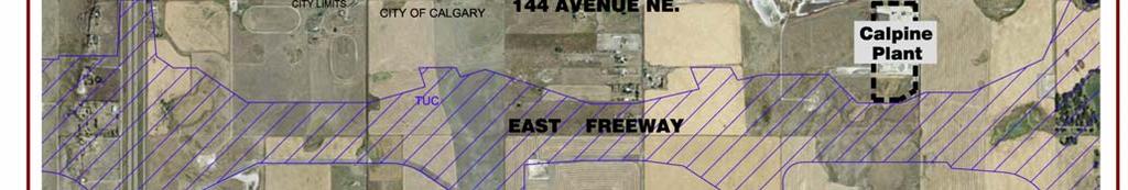

19 FIGURE 4 Air Photo Page 14
20 The Genesis North Calgary Commercial Campus (247 gross acres); The planned regional harness racing recreation facility to be located south of Commercial Campus (estimated 440 gross acres); The existing Westland Distributors soil packaging and distribution facility located within the Wagon Wheel Conceptual Scheme Area (approximately 40 acres); The Nexen Gas Plant facilities located south of the Scheme Area and adjacent to MacDonald Lake on approximately 640 acres; and The Direct Control Bylaw #C (approved by Rocky Council in October 2004) for the Rancher s Beef meat processing facility to be located immediately east of the Nexen facilities (approximately 80 acres). 2.5 Physical Site Features Existing Structures There are two existing farm dwellings currently located within the 480-acre Conceptual Scheme Area (see Figure 3). One farm house and accessory building cluster is located on the 40-acre parcel in NE10. This parcel is expected to remain in agricultural use as long as possible, with ultimate conversion to industrial uses under the policies of this Conceptual Scheme. The existing driveway access to Highway #566 will be relocated to an appropriate location on Range Road #292 as part of the development process for adjacent lands. The second farm house is located immediately south and east of Highway #566 and Range Road #292 on an existing 40-acre parcel in NW11. This house, barn, and existing driveway access to Range Road #292 will be removed in order to accommodate industrial development Topography and Drainage Land slopes very moderately from an elevation of about 1096 metres at the north boundary near Range Road #292 toward a low point of 1088 metres at the southeast corner of the Area (see Figure 5). The Area is located in a drainage catchment area tributary to the northwest of McDonald Lake. However, the existing landscape features include several self-contained areas draining to individual seasonal slough areas. McDonald Lake is located immediately south of the Scheme Area. It is currently a self-contained water body with no direct surface drainage system to local creeks. A preliminary stormwater management concept for Conceptual Scheme Area has been prepared and more detailed stormwater management concept will be prepared at the subdivision stage. Policies regarding stormwater management are contained in Section Utilities and Protective Services. Page 15
21 FIGURE 5 Topography Page 16
22 2.5.3 Gas Pipelines Nexen operates the existing gas lines located in easements along the north boundary of SE W4M and SW W4M (see Figure 3). The Alberta Energy and Utilities Board (AEUB) has identified this pipeline as a Level 1 facility. There is no development setback requirement from a Level 1 pipeline. Therefore, the gas line and existing easement will be incorporated into future development sites and will not present any significant constraint to development Soils Based on the Alberta Spatial Information System website, soils throughout the Conceptual Scheme Area are rated as Canada Land Inventory (CLI) Capability for Agriculture Class 2 (90%) and Class 6 (10%). Class 2 soils have moderate limitations for agriculture while Class 6 soils are suitable for perennial forage use only Archaeological and Historical Conditions The Conceptual Scheme Area has been reviewed by Alberta Community Development and is not an area of known or anticipated archaeological or historical artifacts. Alberta Community Development has granted clearance for development within the Scheme Area Vegetation The majority of the Scheme Area has been under cultivation and therefore contains no significant areas of natural vegetation. An existing tree belt located in NE 10 is located along the west edge of the former farmstead driveway. This driveway has recently been relocated from Highway #566 to Range Road 292. The remaining tree belt contains the only mature trees existing in the Scheme Area. Retention of these trees within the future development could provide an attractive visual and landscape amenity Geo-Technical Evaluation Geo-Technical Evaluations have been completed by Sabatini Earth Technologies Inc. for SW W4M and for NW W4M. These investigations included drilling 41 test holes, laboratory testing, analysis of soil data and the preparation of a supporting report. These reports are available under separate cover. The soil and groundwater conditions are considered favourable for construction of the proposed development provided that the recommendations given in this report are followed. Suitable foundation systems for the proposed buildings are spread and/or strip footings. An alternative foundation system consisting of castin-place piles and pavement design are also included. Page 17
23 2.5.8 Environmental Site Assessment A Phase 1 Environmental Site Assessment (ESA) has been completed by Sabatini Earth Technologies Inc. for SW W4M. The ESA consisted of a records review, a site inspection, soil and water sampling for analysis of petroleum constituents, amines and salinity, and the reporting of findings. This report is available under separate cover. The information gathered during the course of the investigation did not reveal evidence of contamination. The authors indicate that No further action is recommended at this time. Given the historical agricultural land uses and absence of previous industrial activity, environmental concerns are not anticipated within the remainder of the Scheme Area. Page 18
24 3.0 Land Use and Subdivision 3.1 Overview Wagon Wheel Industrial Park will be developed as a vibrant and successful Business and Industrial Park area that accommodates a broad range of employment uses consistent with M.D. of Rocky View economic development objectives for the East Balzac area. Policies contained in this section provide a comprehensive land use, subdivision, and development framework for the Conceptual Scheme Area in accordance with the Rocky View Council s terms of reference approved in February 2004, and the Balzac East Area Structure Plan (as amended). The Balzac East Area Structure Plan (2005) identifies the Scheme Area as appropriate for transition to business and industrial land uses (see Section 1.5 for details). The future business/industrial context for this area has now been established in municipal policy. The Balzac East Area Structure Plan (2005) requires in Section for: proposals for development within SDA#4 to provide a rationale for proceeding prior to build out of the designated business areas. The rationale for short-term development has been demonstrated by strong market demand, location attributes that support a different market niche than designated Business Areas, recent industrial approvals in the Scheme Area (Westland Distributors), and nearby industrial approvals such as Rancher s Beef (see Section 1.6). The Wagon Wheel Industrial Park is ideally located to contribute toward construction of key links in the regional roadway network that will support other planned developments and infrastructure upgrading in the East Balzac area. 3.2 Land Use The Land Use and Transportation Concept for the Wagon Wheel Industrial Park is illustrated in Figure 6. This figure shows how the land use cells described under the BEASP and Direct Control Bylaw C affect the subject lands. Figure 6 illustrates the location of the Transition Land Use area. These lands will be subject to the SDA #4, Cell A land use policies of the BEASP and Direct Control Bylaw C Outdoor storage will not be permitted in this area. Highway widening and additional development setbacks will be provided in this area by incorporating a public linear park, increased building setbacks, on-site landscaping requirements, and architectural guidelines to ensure development provides an attractive interface with Highway #566 and the residential areas north of the highway. Appropriate business, industrial and commercial land uses in the Transition Land Use area will include: Page 19


25 FIGURE 6 Land Use/Transportation Concept Page 20
26 those developments where activities and uses are primarily carried on within an enclosed building and no significant nuisance factor is created or apparent outside an enclosed building. [Rocky View Land Use Bylaw General IndustryType I]. Additional uses on Transition Land Use properties could include retail commercial and institutional uses. Some retail commercial uses will cater to community and regional markets while others will cater to the convenience needs of local employees and East Balzac residents. Remaining parts of the Scheme Area, beyond the Transition Land Use area will be appropriate for a broader variety of business and industrial uses in accordance with the Special Development Area #4, Cell C policies of the BEASP and Direct Control Bylaw C Opportunities for heavier industrial uses should be located primarily toward the south end of the Scheme Area where a number of heavy industrial uses have already been established or approved (e.g., Nexen Gas Plant, Calpine Power Plant, Rancher s Beef Plant, former Shell Refinery Site). Direct Control District development guidelines (e.g., building setbacks), and architectural guidelines will ensure development provides an attractive interface with Range Road #292 and adjacent agricultural operations. Appropriate development in these remaining Conceptual Scheme areas will include: those developments in which all or a portion of the activities and uses are carried on outdoors, without any significant nuisance or environmental factors such as noise, appearance or odour, extending beyond the boundaries of the site. [Land Use Bylaw General Industry Type II]; and, those developments which may have an effect on the safety, use, amenity, or enjoyment of adjacent or nearby sites due to appearance, noise, odour, emission of contaminants, fire or explosive hazards, or dangerous goods. [Land Use Bylaw General Industry Type III]. Policy Policy Land uses within the Conceptual Scheme Area shall include a full range of industrial, business, commercial and institutional land uses in conformity with the policies of the Balzac East Area Structure Plan (as amended). Land use and development in the Highway #566 Transition Land Use area shall be compatible with residential development on the north side of the highway. Page 21
27 Policy No development within the Highway Transition Land Use Area shall create any significant nuisance factor outside an enclosed building. Policy Development standards and architectural guidelines described in this plan and in the Balzac East Area Structure Plan shall be adopted to ensure that all development on properties adjacent to Highway #566 and Range Road 292 will present an appropriate visual interface with these public roadways. Policy Land uses within the Conceptual Scheme Area shall be governed by a Direct Control District that will establish landscaping, architectural control, and other means to ensure that development is compatible with existing and planned land uses adjacent to any specific development site. Policy Developments located outside the Transition Land Use area may include Type Ill industrial uses that create emissions beyond the building or site. Developments that may involve noise, odour, atmospheric particulates, or other emissions beyond the site will be required to demonstrate methods that will successfully mitigate and minimize such emissions in accordance with relevant Federal, Provincial and municipal standards, and to the satisfaction of the M.D. of Rocky View. 3.3 Subdivision The Ultimate Subdivision Concept for Wagon Wheel Industrial Park is illustrated in Figure 7. Existing Wagon Wheel stakeholder-partners and market research have indicated a demand for lots in the range of 3 to 5 acres in size for general industrial development. The planned roadway and block pattern illustrated in Figure 7 will accommodate lots as small as 2 acres in size. Larger lot sizes in the range of 5 to 20 acres can be accommodated by the subdivision concept. Larger lot users are expected to be located toward the south and southeast parts of the Scheme Area. Page 22


28 FIGURE 7 Ultimate Subdivision Page 23
29 Land Use and Subdivision Statistics (acres) USE NE 10 NW 11 SW 11 TOTAL Industrial (1) Highway Widening Internal Roads Linear Open Space (2) Total (3) (1) Industrial includes stormwater management land (2) Total area excludes original RR #292 road allowance (includes widening) (3) Highway 566 and Windrow parks calculated at 20 m and RR #292 calculated at 10 metres. Detailed design to occur at subdivision stage. Policy Policy Subdivisions within the Conceptual Scheme Area shall be in general conformity with the block configuration illustrated in Figure 7. The exact size of individual parcels shall be determined at the subdivision stage. Page 24
30 4.0 Transportation 4.1 Regional Road System The planned roadway system for the Wagon Wheel Industrial Park is illustrated in Figure 6 Land Use and Transportation Concept. Traffic to/from the subdivision will initially access the regional road system via the Highway 566/Range Road 292 intersection. The majority of traffic flow during initial phases will use Highway 566 to access Primary Highway #2 via the Balzac Interchange. At full build-out of the subdivision it is anticipated that subdivision traffic will also be able to access the regional road network using Range Road 292 to connect south to the planned Stoney Trail freeway and the Calgary ring road freeway system. This Conceptual Scheme anticipates possible future widening of Highway #566 to allow for future twinning of the highway in accordance with requirements of the Balzac East Area Structure Plan and advice provided by Alberta Transportation in a letter to the M.D. of Rocky View dated June 23, 2004, wherein: From preliminary information from the FPS noted previously, it appears that Highway 566 will ultimately have a 70 metre right of way. It is not yet known, however, where this additional right of way will be acquired, in relation to the existing Highway 566 right of way. In a worst-case scenario the additional 30 metres of right of way could be needed from the south side of Highway 566. No direct access to/from Highway #566 will be permitted from individual properties within the Wagon Wheel Industrial Park. Access to/from the Scheme Area will be from an internal road network connected to Range Road 292. Range Road 292 will be constructed as a major industrial/commercial collector roadway in conformity with the Balzac East Area Structure Plan and to the satisfaction of the Municipal District of Rocky View. Direct access to Range Road 292 from individual properties will be strictly controlled to minimize disruption of through traffic. The Wagon Wheel Industrial Park Traffic Impact Assessment (Finn Transportation Consultants, May 11, 2004) assessed the existing traffic conditions and the post-development traffic conditions at key intersections near the Conceptual Scheme Area. The study found that at full build out, which is anticipated to occur in about 15 years time, the Industrial Park is expected to generate approximately 2,700 vehicle trips in the morning peak hour (1,900 inbound and 800 outbound), and 3,500 vehicle trips (1,200 inbound and 2,300 outbound) during the afternoon peak hour. Based on the phased build-out and traffic volumes within the area, the study draws the following conclusions. The intersection of Highway 566 and Range Road 292 will be able to adequately accommodate site-generated traffic volumes in the short-term Page 25
31 (2005) future planning horizon with significant spare capacity to accommodate other development in the area. At the medium-term horizon (2010) the intersection will require signalization, a westbound left-turn lane, an eastbound right-turn lane, and a northbound left-turn lane. In the long-term horizons (2015 and 2020) the twinning of Highway 566 and widening of the northbound RR 292 approach will be required to maintain the intersection at acceptable level of service. Widening of the south leg of Range Road 292 to 3 lanes will also be required. Policy Policy Policy Policy Policy Policy Policy Policy Policy Development shall satisfy the requirements of Alberta Transportation with respect to protecting the function of Highway 566. Development shall provide required road right-of-way widening on Highway 566 to the satisfaction of Alberta Transportation. A minimum 36 meter right of way will be required by the Municipality for Range Road 292. Access to the subdivision shall be generally in accordance with Figure 6. Direct access from lots to Highway 566 will not be allowed. Direct access to Range Road 292 will be restricted based on the recommendations of a Traffic Impact Assessment, at the discretion of the Municipality. A Traffic Impact Assessment shall be prepared, prior to each phase of subdivision, to the satisfaction of the Municipal District of Rocky View and Alberta Transportation. The TIA will address any upgrades required for both the internal road and existing regional road network. The development will provide and maintain appropriate emergency vehicle access in accordance with Municipal standards. Subject to Alberta Transportation approvals, Interim emergency access to Highway #566 may be required pending full build-out of the regional road system. The developer shall dedicate those lands required for intersectional upgrades at Range Road 292 and Highway 566 as a condition of subdivision. Until such time as direct links occur with adjacent road networks in the future, the municipality may require interim cul-de-sac bulbs at the terminus of roads. In such cases, the necessary Access Easement Agreement and access Page 26
32 Policy right-of-way plan of survey will protect those portions of the cul-de-sac bulb that may encumber adjacent parcels. Range Road 292shall be constructed to the southern most boundary of the Conceptual Scheme Area subject to subdivision phasing as approved by Council. 4.2 Internal Road System An east/west collector roadway will be located approximately 400 metres south of Highway #566. This will allow all turning movements to be adequately separated from turning movements at Highway #566. A second east/west collector roadway is located at the south boundary of the Conceptual Scheme Area. These alignments provide for the future extension of the industrial collector roads west of Range Road 292 thereby allowing for a regional collector roadway network in conformity with the East Balzac Area Structure Plan. Collector roadways are to be built to the satisfaction of the Municipal District of Rocky View. Policy Policy Policy Policy Policy Policy Policy Policy Complete Road Systems shall be constructed by the Developer to the satisfaction of the Municipal District of Rocky View. Emergency (or secondary) Access shall be provided until such time as a direct link occurs with adjacent road networks to the satisfaction of the Municipality. No Development Permit will be issued until a Development Agreement has been entered into and the required Road System has been constructed and received a Construction Completion Certificate (C.C.C.). The Developer will construct and maintain the roadways and associated infrastructure until such time as an FAC is issued by the Municipality. All intersectional upgrades shall be constructed by the Developer to the satisfaction of the Municipal District of Rocky View and Alberta Transportation. The exact location of road approaches and lot accesses may be deferred to the Development Permit stage. A Transportation Off-Site Levy shall be paid by the Developer to the Municipality in accordance with the Transportation OSL Bylaw, as amended. Cost sharing and/or Endeavours to Assist can only be considered where oversized infrastructure is provided beyond what is required for the development, at the sole discretion of Council. Page 27
33 5.0 Public Parks and Pathways 5.1 Parks and Pathways The Wagon Wheel Industrial Park is planned to provide: edge conditions that are complementary to surrounding land uses, an attractive setting for a broad range of businesses and industries; multi-use pathways that are located to allow for possible future extension by others to the west and south of the Wagon Wheel Conceptual Scheme Area. The main element of the park system will be a proposed municipal reserve public linear park located south of Highway 566 and along the west side of Range Road 292 (see Figure 6). This linear park system will also extend south into the industrial area in NE10 in order to incorporate an impressive existing windrow of mature poplar trees. The linear park will provide an attractive land use buffer along the north edge of the industrial area. In addition the park will accommodate a public recreational pathway system linking to planned and proposed pathways along the south side of Highway #566 and along the west side of Range Road #292. A proposed 2.0 metre regional asphalt pathway will be located within these linear park areas. The Highway 566 linear park landscape plan is illustrated in Figure 8. The linear park will contain a 1-2 metre high landscaped berm designed to visually screen the ground level of adjoining business industrial sites so these activities are not conspicuous when viewed from the highway or residential areas to the north. This berm will be designed as a meandering landform with a natural appearance. A mix of deciduous and evergreen trees will provide additional year-round visual screening. Trees will visually soften the partial view of industrial buildings over the berm height. A 2.0 metre asphalt regional public pathway will also meander within the linear park on the north (highway) side of the berm. The exact alignment of the pathway within the linear park will be well separated from the future highway and subject to detail designs to be undertaken at the subdivision stage. Policy Policy A detailed Highway 566 linear park landscape plan shall be provided to the satisfaction of the MD in support of initial subdivision or development approvals within NE10 or NW11. Any landscape plan submitted in accordance with Policy should incorporate native and indigenous plant material in accordance with the Balzac East Area Structure Plan policy (m). Page 28


34 FIGURE 8 Highway 566 Transition and Park Concept Page 29
35 Policy Policy Policy Dedication and landscaping of the Highway 566 and Range Road 292 linear parks shall be secured at the time of initial subdivision and development approvals within each quarter section. A 2.0 metre paved regional pathway will be constructed by the developer within the Highway 566 linear park and the Range Road 292 linear park. Linear pathways will not be permitted within the road rightof-way. 5.2 Municipal Reserve The Municipal Government Act (MGA) allows a municipality to require that a landowner/developer allocate and dedicate up to 10% of land being subdivided for purposes of providing public parks. The Highway 566 linear park and the Range Road 292 linear park will qualify as municipal reserve land for public park and pathway uses. The linear park concept allows more flexibility for alignment of the public pathway system and avoids locating the pathway directly within the municipal road right-of-way. Although the MD of Rocky View will take ownership of the Municipal Reserves the park will be maintained by a Wagon Wheel Lot Owners Association. At the time of subdivision and development all developer landowners within the Wagon Wheel Conceptual Scheme Area will be required to participate in a Lot Owner s Association as a condition of a caveat on title of each lot. The purpose of the Lot Owner s Association will be to maintain specified municipal reserve lands and other commonly owned and maintained infrastructure. Additional requirements for public schools and/or public parkland to serve employees within the industrial area are not currently anticipated. Policy Municipal Reserve will be provided in full pursuant to the provisions of the Municipal Government Act. Policy The municipality will take ownership of the Highway 566 linear park and the Range Road 292 linear park as part of the Municipal Reserve park system. Policy Membership in a Lot Owner s Association shall be a requirement of any new industrial subdivision or development within the Conceptual Scheme Area. A Lot Owner s Association shall be permanently responsible for municipal reserve parkland, which includes maintenance and liability protection, pursuant to an agreement with the Municipality. Page 30
36 5.3 Environmental Reserve There are no lands within the Conceptual Scheme Area that are known to qualify as Environmental Reserve under the Municipal Government Act. Located at the extreme southeast corner of the Conceptual Scheme Area, McDonald Lake is a crown-owned body of permanent water. At the time of subdivision within SE 11 the shoreline of McDonald Lake should be surveyed and, if required, appropriate setbacks shall be established for development and/or public access. Policy Appropriate setbacks for public access and development stability near the shoreline of McDonald Lake will be determined at the subdivision stage of development in accordance with the direction of Alberta Sustainable Resource Development. Page 31
37 6.0 Development Standards Development standards and architectural guidelines will be used at the development permit stage to ensure that all new site developments will be compatible with adjacent land uses and provide a good quality appearance when viewed from public arterial roadways (i.e., Highway 566 and Range Road 292). 6.1 Building Setbacks The following minimum building setbacks will apply to all new development in order to ensure spacious setbacks from public roadways and to provide for greater setbacks than are normally required under the Land Use Bylaw where sites abutting Highway 566 or agricultural lands adjacent to the Conceptual Scheme Area. Minimum from any property line: Minimum from property line abutting the Highway 566 r.o.w., linear park, or frontage road Minimum from permanent agricultural land or lands without an approved conceptual scheme 10 metres 30 metres 30 metres Policy Building setbacks as described in Section 6.1 shall be implemented in order to provide an attractive, comprehensively designed industrial park and ensure that new development is compatible with surrounding land uses. 6.2 Site Landscaping The Wagon Wheel Industrial Park will be designed to accommodate a broad range of business and industrial land uses within a comprehensively planned and landscaped environment. Landscaping throughout the Industrial Park will be undertaken in accordance with the following policies. Policy Policy Landscaping on each lot shall be concentrated in the front yard area adjacent to public road rights-of-way and/or in a manner that complements the Highway 566 and Range Road 292 linear park and pathway systems. No outdoor display areas, storage areas, parking or marshalling yards shall be allowed within landscaped yards. Page 32
38 Policy Policy Policy Planting of trees and shrubs within landscaped areas shall be in accordance with, or exceed landscaping standards of the Rocky View Land Use Bylaw and the Balzac East Area Structure Plan. Landscaping, hard or soft, other than topsoil and seeding will not be permitted within the Road right-of way. The Developer shall implement the landscaping plan to the satisfaction of the Municipality. 6.3 Highway 566 Development Guidelines The visual quality of development adjacent to Highway 566 is important because these lands interface with residential areas on the north side of the highway. Previous sections of this Conceptual Scheme ensure a high quality visual interface with policies that require highway widening land, landscaped linear park areas, additional building setbacks from property lines, and allocating a high proportion of on-site landscaping to be oriented toward Highway 566. In addition sites abutting Highway 566 will be subject to the following development policies. Policy Policy On sites abutting Highway 566, no loading bays, loading doors, or other activities creating heavy truck movements will be allowed to be located on building facades facing toward Highway 566. On sites abutting Highway 566, the major customer entrance to the building should be located facing Highway 566, along with customer car parking areas and appropriate customer entry features such as windows and architectural entry treatments. 6.4 Special Architectural and Landscaping Guidelines The following Architectural and Landscaping Guidelines will apply to sites that abut Highway 566 or Range Road 292. The guidelines are intended to promote and ensure achievement of a coordinated and pleasant visual presence toward these high volume public through roads without necessarily restricting the range of industrial uses or variety of building styles that can occur. a) Building design emphasis should be on those building elevations that are openly visible from Highway 566 or Range Road 292. b) Within any single parcel, the colours, materials and finishes of all buildings shall be coordinated to achieve a reasonable continuity of appearance. c) All buildings shall be permanent structures with good quality exterior finishing materials which may include quality metal panel products, pre-cast concrete, architectural site-cast concrete, architectural tile, and commercial grade Page 33
39 stucco, brick or stone masonry,. Wood, unfinished concrete and concrete block may be used as a secondary material only. d) Facades of buildings which exceed 31 metres measured horizontally, and facing public roadways, shall incorporate wall plane projections or recesses having a depth of at least 3% of the length of the façade and extending at least 20% of the length of the façade. e) Facades of buildings facing onto Highway #566 or Range Road 292 shall include at least three of the following architectural elements: colour change; texture change; material module change; expression of architectural or structural bay through a change in plane such as an offset, reveal, or projecting rib. f) Rooftop apparatus should be located and concealed to reduce or eliminate public view from adjacent roads g) Roofs should have at least two of the following features: Parapets concealing flat roofs and/or rooftop mechanical and electrical equipment Overhanging eaves extending past the supporting wall Sloping or pitched roofs with two or more roof slope planes Roof-top gardens that support ecological functions such as stormwater retention, building insulation, bird habitat, outdoor green space, etc h) Each primary building shall have a clearly defined main entrance featuring at least two of the following: Canopy or portico Overhang or arcade Raised corniced parapet over the door Outdoor amenity area Upgraded window glazing areas Integrated planters or landscaped sitting areas i) A minimum 3.0 metre landscaped area shall be provided between the front of any primary building and any adjoining parking or lot area. j) Loading docks, garbage storage and other service areas shall be concealed from public view through use of screening materials that are consistent or complementary with the architectural theme of the primary building. k) Outdoor display, storage, and operations yards, shall not be located within minimum required landscaped yards. l) A landscape plan shall be submitted with each development application which demonstrates the following requirements: Page 34
40 i. Plant material proven for the climate of the Calgary region and available water resources for long-term maintenance; ii. The same or similar mix of tree species planted in front yards and/or boulevards along both sides of a road for visual continuity; iii. Avoid species monoculture over large areas; iv. Retaining walls and front yard fencing shall be decorative as well as functional and integrated into the front yard landscape design; v. Decorative feature walls or low-profile landscaped berms including mass plantings of flowering shrubs, evergreen shrubs, or decorative tall grass species should be incorporated into the landscape designs at key public intersections and entryways without interfering with necessary traffic sight lines. Policy All Development Permit plans for sites abutting Highway 566 or Range or Range Road 292 should be in conformity with the Special Architectural and Landscape Guidelines contained in Section 6.4 of this Conceptual Scheme. 6.5 Lighting Plan The M.D. of Rocky View supports a dark sky policy in order to conserve energy, reduce lighting overspill beyond site boundaries, and promote the visibility of stars and night skies. Security and general night lighting on private sites should be designed to respect the objectives of a dark-sky Policy All private lighting including site security lighting and parking area lighting should be designed to conserve energy, reduce glare and reduce uplight. All development will be required to demonstrate lighting design that reduces the extent of spill-over glare and eliminates glare as viewed from nearby residential properties. 6.6 Signage Plan Signage guidelines are intended to promote and ensure achievement of a coordinated and pleasant visual presence throughout all parts of the Wagon Wheel Industrial Park. The following guidelines will apply to all development within the Wagon Wheel Conceptual Scheme Area. a) Signage shall be subject to approval as part of the development permit to match the design and material of buildings. b) Signage should be constructed of permanent, high quality material and designed such that signage proliferation will not create an excessive or garish appearance from public roads. c) No signage shall project higher than the roof height of the building to which it is attached. Page 35
41 d) Signage should include multi-tenant identification signs, gateway signs, entry, corner, and directional signs, corporate pylon signs, facia signs, wall signs, and message signs. Roof signs and projecting signs will not be acceptable. e) Signs internal to a site may be individually themed for corporate presentation in terms of design, scale, materials, and colours. Policy Policy All signage in the Wagon Wheel Industrial Park shall conform with the Sign Plan guidelines contained in Section 6.6 of this Conceptual Scheme. No signage other than Traffic Control Devices shall be permitted within the Road right-of-way. 6.7 Fencing Plan Fencing plays a prominent role with respect to public visibility. The general perception of businesses throughout an industrial park can be negative if there is a proliferation of different security fencing and fencing materials. The following considerations should guide fencing development throughout the Wagon Wheel Industrial Park. a) No security fencing shall be erected in a required front yard facing a public street. Front yard areas may contain decorative low scale fence that is architecturally consistent and integrated with the overall building design. b) Impermanent and/or lightweight fencing materials will not be acceptable. c) The municipality may require that all lots in a particular subdivision phase be provided with a good-quality project fence to be maintained by the developer or a Lot Owner s Association. d) Vinyl-coated chain link fencing combined with landscaping is preferred for site areas that are visible to public roadways. Use of standard security chain link fencing should be limited to portions of the site where security is necessary. Policy Fencing in the Wagon Wheel Industrial Park shall conform with the fencing guidelines contained in Section 6.7 of this Conceptual Scheme. Page 36
42 7.0 Utility and Protective Services 7.1 Interim and Ultimate Utility Servicing Development in the Wagon Wheel Conceptual Scheme Area has commenced with the approved Westland Distributors soil packaging and distribution facility. This facility is being developed with limited services. Conceptual Scheme stakeholders are currently working with the M.D. of Rocky View and other landowners in the Balzac East area to finalize a strategy for communal servicing for the East Balzac area including the Conceptual Scheme Area. Any new development under this Conceptual Scheme requires provision of a communal piped water supply system. Prior to full build-out as illustrated in Figure 7, the Wagon Wheel Industrial Park will require communal water and sanitary services. It is anticipated that further development may occur on the basis of a communal water system and prior to completion of full communal sanitary and stormwater services for ultimate development. Any interim development will comply with Rocky View s Servicing Standards for Subdivision and Road Construction, Policy Policy Policy All water supply, wastewater disposal and stormwater management systems shall be designed to allow for integration into a future regional servicing system. A Deferred Servicing Agreement (DSA) shall be registered against each individual title to allow for connection to a regional system to the satisfaction of the MD of Rocky View. Shallow and/or deep utilities will not be permitted under the road structure or within the road right-of-way (as required for subdivision) unless otherwise approved by the Municipal District of Rocky View. Utility installation shall be subject to protection via easement within private property/lands. 7.2 Water Supply Potable water will be supplied by the Rocky View Water Coop. Ltd. or an equivalent communal water system to the satisfaction of the M.D. of Rocky View. A piped communal distribution system will be provided to serve all new industrial lots. Subject to required water approvals, an aquifer or groundwater supply may be acceptable for non-potable uses such as, but not necessarily limited to, industrial process operations and topping-up of fire-protection ponds, where appropriate supply and demand conditions are proven to the satisfaction of the municipality. Page 37
43 Policy Policy Water shall be supplied by a municipal potable water system or a communal piped distribution system to the satisfaction of the MD of Rocky View and in accordance with the Alberta Water Act. The developer shall obtain all necessary Municipal and Provincial approvals for potable water supply for commercial purposes. 7.3 Sanitary Wastewater Interim sanitary sewage disposal will occur through pump out tanks until such time as connection to a private or municipal communal wastewater treatment system is available. Deferred Services Agreements will be registered on all titles to ensure that all lots will be connected to the future piped system in a timely manner. Policy Sanitary Wastewater systems shall be designed in accordance with applicable municipal, provincial, and federal standards and shall be provided to the satisfaction of the M.D. of Rocky View. Policy Interim wastewater disposal may occur through the use of individual or communal pump out systems. Policy The developer shall obtain all necessary Municipal and Provincial approvals for prior to installation of individual or communal private pump-out tanks. Policy A collection and treatment system may be required prior to full build out of the Conceptual Scheme area. Policy As a component of any subdivision or development application, the applicant will provide information regarding the opportunity to recycle their wastewater for re-use in other adjacent industrial processes to the satisfaction of the Municipality. Policy A Deferred Servicing Agreement (DSA) shall be registered against each individual title describing the lot owner s obligations for participation in a future Municipal wastewater treatment system. 7.4 Stormwater Management A Stormwater Management report by Westhoff Engineering Resources Inc. (November 29, 2004) identifies five local catchment areas within the Conceptual Scheme boundaries. These are self-contained areas that currently drain toward individual slough or seasonally wet areas. Based on the existing contours and Page 38
44 the proposed roadway system, five future stormwater pond locations are identified to serve the Scheme Area as illustrated in Figure 7. Stormwater from all new industrial lots will drain to local stormwater ponds via grassed swales located within easements on private property and in roadside ditches. Stormwater ponds will be dedicated to the municipality as public utility lots or owned and managed by a Lot Owner s Association. The Conceptual Scheme Area is tributary to McDonald Lake. McDonald Lake is located at the far southeast corner of the Scheme Area. The preferred approach for stormwater management will be a combination of on-site stormponds to capture run-off from frequent storm events while excess runoff due to rare, large storm events is conveyed to McDonald Lake. This will require allocating about 10% of the Scheme Area to storm ponds and sizing the ponds accordingly. This concept provides for control of frequent storms, but the ponds can be designed and operate as wet ponds to include a dead storage capacity that would be available to store water for fire protection, irrigation, dust control, and possibly other uses (e.g., toilet flushing). Use of these Best Management Practices (BMPs) will be required. Grassed conveyance ditches along the roadways and stormwater detention in ponds are BMP s that are recognized and encouraged by the MD of Rocky View. The road system may not be used for stormwater storage purposes and all retention must occur in designated public utility lots and/or stormwater management infrastructure. These practices will allow for significant stormwater quality enhancement. Should occasional release to McDonald Lake not prove feasible, then all stormwater will need to be retained in larger ponds until such time as an alternative outlet is approved or regional stormwater system installed. Policy Policy Policy Policy All stormwater management shall be in accordance with Alberta Environment s Best Management Practices and the M.D. of Rocky View s Servicing Standards for Subdivision and Road Construction. A Stormwater Management Plan will be required in support of each phase of subdivision to the satisfaction of the Municipality. Storm water management ponds shall be maintained and operated by a Lot Owner s Association. Any discharge of Stormwater into MacDonald Lake shall have all necessary municipal and provincial approvals. Page 39
45 7.5 Shallow Utilities Shallow utility services including electric power, natural gas, telephone, cable and high speed internet services will be provided by local utility companies. A mix of underground utilities and overhead power lines will be located within the road rights-of-way and easements as required to serve all new industrial lots. Policy Shallow utilities shall be provided within the Scheme Area at the sole expense of the developer within appropriate rights-of-way established at the subdivision stage. 7.6 Solid Waste Solid Waste Management will be the responsibility of property owners. The majority of property owners will use a local commercial solid waste disposal service. Policy A Deferred Servicing Agreement (DSA) shall be registered against each individual title describing the lot owner s obligations for participation in a possible future solid waste handling system. 7.7 Protective Services Police service to the Scheme area is provided by the Royal Canadian Mounted Police and MD of Rocky View Special Constables. Fire protection will be provided by the City of Calgary Fire Department. The Scheme Area will be serviced by 911 emergency services with an emergency locator system set up for each individual property. Fire protection for the area will be provided from either a potable water supply system, or from a private fire-fighting water system. Where adequate sustained flows are not available from the potable water systems, the private fire-protection system will be built to provide water supply, pumping, distribution, and hydrants or holding tanks as required throughout the subdivision. Stormwater ponds throughout the industrial park will be designated to store sufficient water to sustain fire flows. Pump stations will provide water for fire protection throughout the Scheme Area. The City Fire Department will access water at fire hydrants located along the line. The separate fire-fighting system will be constructed by the developer and privately maintained by the owners of lots within the subdivision. Policy New subdivisions shall meet the criteria and requirements for on-site fire fighting measures as determined by the M.D. Page 40
46 Policy Policy of Rocky View. A fire suppression system will be privately owned and maintained. Details of fire fighting measures including system design, capacity, equipment, operation and maintenance shall be provided at subdivision stage. An Emergency Management Plan shall be submitted with each development permit application to the satisfaction of the MD of Rocky View. Development Permit plans will be encouraged to consider and incorporate principles of Crime Prevention Through Environmental Design (CPTED). Key principles for public and semi-public areas could include design for vehicular access by security patrol car, minimizing building entrances, eliminating blind alleys or hiding places, spacing of plant materials, building setbacks, and keeping entrances well-lit, well-defined and visible to public and patrol vehicles. 7.8 District Energy There are two gas-fired electric plants located on the southeast side of McDonald Lake. The Calpine Power plant and the Nexen Gas Plant both incorporate gasfired electric power generation facilities. These operations may provide an opportunity to incorporate a District Energy system into future industrial developments in the surrounding area. Opportunities will be explored to identify the feasibility of specific options for incorporating District Energy systems into new development (e.g., power and heating) for more efficient use of energy and reduced total energy costs. Policy Policy Policy Wagon Wheel Industrial Park stakeholders and developers will explore alternatives for District Energy and Eco- Industrial reuse of industrial byproducts with existing and future industries in the East Balzac Area. Subdivision and/or development applications shall include a status and feasibility report regarding the potential for District Energy. Implementation of recommendations shall be through subdivision and development permit, to the satisfaction of the MD of Rocky View. Coordination of District Energy strategies will be facilitated by the Lot Owners Association. Rights-of-way will be established at the subdivision stage to provide for implementation of District Energy strategies. Page 41
47 8.0 Implementation 8.1 Process Implementation of this Conceptual Scheme will occur through the land use redesignation and subdivision approval processes. This Conceptual Scheme provides a framework of policies and requirements that complement the policies contained in the Balzac East Area Structure Plan (as amended). These policies will guide subsequent subdivision and development approval processes to achieve phased development of a high-quality industrial park within the MD of Rocky View. It is anticipated that a Direct Control District will be adopted for the entire Wagon Wheel Industrial Park Conceptual Scheme Area. This will ensure that all lands within the Conceptual Scheme are subject to coordinated development requirements and obligations under a Lot Owner s Association. The Direct Control District will contain performance requirements and development guidelines that are consistent with the land use policies and development concepts contained in this Conceptual Scheme. These policies will ensure that a broad range of general business and industrial uses are developed in a manner that is compatible with adjacent land uses. Policy Policy The M.D. of Rocky View shall implement this Conceptual Scheme through the land use redesignation, subdivision, and development approval processes. A Lot Owners Association shall be established to assume eventual responsibility for common lands and infrastructure at the time of subdivision. 8.2 Development Standards The specific Development Standards referenced in Section 6.0 of this Conceptual Scheme will be implemented through a Direct Control District under the Rocky View Land Use Bylaw. In addition to the Development Standards referenced in Section 6.0 of this Conceptual Scheme, the general Business Use Performance Standards and Development Guidelines contained in the Balzac East Area Structure Plan shall be considered by the approval authority during the development approval process. Policy In addition to the policies of this Conceptual Scheme, the Business Use Performance Standards and Development Guidelines contained of the Balzac East Area Structure Plan shall be considered by the approval authority during the subdivision and development approval processes. Page 42
48 8.3 Construction Management Plan The Balzac East Area Structure Plan policy 4.7.4(e) indicates that prior to construction a Construction Management Plan shall be prepared to address dust control, noise, truck routes and access to the site, and potential for interference with any nearby residential areas. Policy A Construction Management Plan shall be provided by the developer to the satisfaction of the M.D. of Rocky View prior to issuance of a Stripping and Grading Permit. 8.4 Phasing Subdivision of the Wagon Wheel Industrial Park is anticipated to occur in phases that are logically related to the provision of infrastructure. This Conceptual Scheme coordinates a number of different development stakeholders. Therefore, early phases of subdivision may occur simultaneously. Although a phasing strategy is illustrated in this Conceptual Scheme, phasing should be subject to market demand and multiple ownerships held throughout the Scheme Area. Each phase of development need not be built out prior to commencement of other phases. Phasing may be modified or advanced where the developer pays all costs associated with necessary infrastructure to serve development. Anticipated phasing is illustrated in Figure 9. Phase 1 will commence development of lands in NW 11 adjacent to the existing Westland Distributors (Balzac) facility. Access to Phase 1 will be provided by the east/west collector alignment located 400 metres south of Highway 566. Dedication of required highway widening and construction/landscaping of the Highway 566 linear park within NW11 will occur at the time of the initial subdivision in Phase 1. Phase 2 will include all land within NE10 with the exception of the existing 40 acre parcel. Due to strong demand and different ownership, development of Phase 2 is anticipated to begin prior to complete build-out of Phase 1. Developments in Phase 2 will initially be accessed by a local industrial east/west roadway located approximately 200 metres south of Highway 566. This location will support all-turns access onto Range Road 292 for the foreseeable future. In the longer term future, this access to Range Road 292 may need to be converted to a right-in/right-out intersection. However, this is not anticipated to be required until after Range Road 292 is linked southward to the planned Stoney Trail freeway. Dedication of required highway widening and construction/landscaping of the Highway 566 linear park within NE10 will occur at the time of the initial subdivision in Phase 2. Page 43


49 FIGURE 9 Phasing Concept Page 44
BALZAC COMMERCIAL CAMPUS CONCEPTUAL SCHEME
 BALZAC COMMERCIAL CAMPUS CONCEPTUAL SCHEME Bylaw C-6664-2008, Adopted July 22, 2008 MUNICIPAL DISTRICT OF ROCKY VIEW NO. 44 Department of Planning and Community Services MUNICIPAL DISTRICT OF ROCKY VIEW
WESTMINSTER GLEN CONCEPTUAL SCHEME
 WESTMINSTER GLEN CONCEPTUAL SCHEME Bylaw C-5379-2001, Adopted July 31, 2001 MUNICIPAL DISTRICT OF ROCKY VIEW NO. 44 Department of Planning and Development MUNICIPAL DISTRICT OF ROCKY VIEW NO. 44 BYLAW
WEST HILL BUSINESS PARK AREA STRUCTURE PLAN
 MUNICIPAL DISTRICT OF PEACE NO. 135 WEST HILL BUSINESS PARK AREA STRUCTURE PLAN Prepared by: TABLE OF CONTENTS 1.0 Introduction... 1 1.1 Purpose of Plan........ 1 1.2 Plan Area..... 1 1.3 Existing Conditions...
LAND USE AMENDMENT CORNERSTONE (WARD 3) 60 STREET NE AND COUNTRY HILLS BOULEVARD NE MAP 26NE BYLAW 22D2017
 60 STREET NE AND COUNTRY HILLS BOULEVARD NE MAP 26NE BYLAW 22D2017") Page 1 of 14 EXECUTIVE SUMMARY This Land Use Amendment application covers an area of 43.76 hectares ± (108.14 acres ±) located in northeast Calgary, bound by Country Hills Boulevard NE to the south and
Page 1 of 14 EXECUTIVE SUMMARY This Land Use Amendment application covers an area of 43.76 hectares ± (108.14 acres ±) located in northeast Calgary, bound by Country Hills Boulevard NE to the south and
CONCEPTUAL SCHEME FULTON INDUSTRIAL
 CONCEPTUAL SCHEME FULTON INDUSTRIAL Bylaw C-6919-2010 Adopted June 22, 2010 ROCKY VIEW COUNTY BYLAW C-6919-2010 A Bylaw of Rocky View County to adopt a Conceptual Scheme known as the Fulton Industrial
MUNICIPAL DEVELOPMENT PLAN
 MUNICIPAL DEVELOPMENT PLAN Bylaw C-4840-97 Adopted on July 6, 1998 MUNICIPAL DISTRICT OF ROCKY VIEW NO. 44 Department of Planning and Development & Building Services MUNICIPAL DISTRICT OF ROCKY VIEW NO.
City of Grande Prairie Development Services Department
 City of Grande Prairie Development Services Department ROYAL OAKS NORTH OUTLINE PLAN OP-07-03 NW 35-71-6 W6M May 7, 2007 Royal Oaks North Outline Plan TABLE OF CONTENTS 1.0 INTRODUCTION........ 3 1.1 Purpose
MUNICIPAL DISTRICT OF ROCKY VIEW NO.
 BEARSPAW AREA STRUCTURE PLAN Bylaw C-4129-93, Adopted January 18, 1994 MUNICIPAL DISTRICT OF ROCKY VIEW NO. 44 Department of Planning and Development BEARSPAW AREA STRUCTURE PLAN BY-LAW C-4129-93 January,
ADMINISTRATION RECOMMENDATION 2016 November 03. That Calgary Planning Commission recommends APPROVAL of the proposed Land Use Amendment.
 Page 1 of 12 EXECUTIVE SUMMARY This Land Use Amendment application covers an area of 75.76 hectares ± (187.20 acres ±) located in northeast Calgary, bound by Stoney Trail NE to the north, 128 Avenue NE
GRAYSTONE ESTATES CONCEPTUAL SCHEME
 GRAYSTONE ESTATES CONCEPTUAL SCHEME Bylaw C-5438-2001, Adopted November 6, 2001 MUNICIPAL DISTRICT OF ROCKY VIEW NO. 44 Department of Planning and Development TABLE OF CONTENTS 1.0 INTRODUCTION 5 1.1 Conceptual
Outline Plan in Belvedere (Ward 9) at Street SE, LOC (OP)
 at Street SE, LOC (OP)") 2018 October 04 Page 1 of 12 EXECUTIVE SUMMARY This outline plan application was submitted by B&A Planning Group on 2016 July 15, on behalf of Tristar Communities Inc. for 50.14 hectares (123.89 acres)
2018 October 04 Page 1 of 12 EXECUTIVE SUMMARY This outline plan application was submitted by B&A Planning Group on 2016 July 15, on behalf of Tristar Communities Inc. for 50.14 hectares (123.89 acres)
OP Council Resolution June 16, Planning and Development Services
 OP-08-01 Council Resolution June 16, 2008 Planning and Development Services Kingsgate Landing Outline Plan Table of Contents 1.0 Introduction 1 1.1 Purpose of Plan 1 1.2 Plan Area Location 1 1.3 Ownership
LAND USE AMENDMENT CORNERSTONE (WARD 3) COUNTRY HILLS BOULEVARD AND STONEY TRAIL NE BYLAW 9D2017
 COUNTRY HILLS BOULEVARD AND STONEY TRAIL NE BYLAW 9D2017") Page 1 of 12 EXECUTIVE SUMMARY This Land Use Amendment application covers an area of 54.92 hectares ± (135.71 acres ±) located in northeast Calgary, bound by Country Hills Boulevard NE to the north and
Page 1 of 12 EXECUTIVE SUMMARY This Land Use Amendment application covers an area of 54.92 hectares ± (135.71 acres ±) located in northeast Calgary, bound by Country Hills Boulevard NE to the north and
Bylaw C-1186 Adopted November 5, Planning and Development Services
 Bylaw C-1186 Adopted November 5, 2007 Planning and Development Services CITY OF GRANDE PRAIRIE OFFICE CONSOLIDATION BYLAW C-1186 A Bylaw to adopt the Westgate Area Structure Plan (As Amended by Bylaw C-1186-1,
TABLE OF CONTENTS. Sierra Springs Outline Plan
 Sierra Springs Outline Plan TABLE OF CONTENTS 1. Introduction...3 1.1. Purpose of the Plan... 3 1.2. The Approval Process... 3 1.3. Policy and Legislative Framework... 3 2. Development Area...6 2.1. Location
ROAD CLOSURE AND LAND USE AMENDMENT SILVER SPRINGS (WARD 1) NORTHEAST OF NOSEHILL DRIVE NW AND SILVER SPRINGS ROAD NW BYLAWS 2C2018 AND 29D2018
 NORTHEAST OF NOSEHILL DRIVE NW AND SILVER SPRINGS ROAD NW BYLAWS 2C2018 AND 29D2018") Page 1 of 19 EXECUTIVE SUMMARY This application proposes redesignating two parcels in the community of Silver Springs from Special Purpose Future Urban Development (S-FUD) District and undesignated road
Page 1 of 19 EXECUTIVE SUMMARY This application proposes redesignating two parcels in the community of Silver Springs from Special Purpose Future Urban Development (S-FUD) District and undesignated road
HAMLET OF KINGMAN AREA STRUCTURE PLAN
 HAMLET OF KINGMAN AREA STRUCTURE PLAN Prepared by: Austrom Consulting Ltd. Page 1 of 19 Table of Contents TABLE OF CONTENTS... 2 1. BACKGROUND... 3 1.1 PLAN AREA... 3 1.2 PLAN PURPOSE... 3 1.3 LEGISLATIVE
S o u t h C e n t r a l O u t l i n e P l a n. Leduc Business Park. North Leduc Industrial Area Structure Plan C it y of Led u c.
 Leduc Business Park North Leduc Industrial Area Structure Plan C it y of Led u c Prepared for Farm Air Properties Inc. January, 2007 Table of Contents Page Number 1.0 Purpose of Plan and Definition of
City of Grande Prairie Development Services Department KENNEDY DEVELOPMENTS LTD. OUTLINE PLAN OP-09-01
 City of Grande Prairie Development Services Department KENNEDY DEVELOPMENTS LTD. OUTLINE PLAN OP-09-01 July 27, 2009 TABLE OF CONTENTS 1.0 Introduction... 1 1.1 Plan Area Location & Context... 1 1.2 Ownership
AREASTRUCTURE PLAN AMENDMENT COCHRANE NORTH
 AREASTRUCTURE PLAN AMENDMENT COCHRANE NORTH In order to implement the vision outlined in the Conceptual Scheme, the following three amendments to the Cochrane North ASP are proposed: 1. Allow commercial
BYLAW C A Bylaw of Rocky View County to amend Land Use Bylaw C
 BYLAW C-7720-2017 A Bylaw of Rocky View County to amend Land Use Bylaw C-4841-97. The Council of Rocky View County enacts as follows: PART 1 TITLE This Bylaw shall be known as Bylaw C-7720-2017. PART 2
ADMINISTRATION RECOMMENDATION(S) 2017 February 09. That Calgary Planning Commission recommends APPROVAL of the proposed Land Use Amendment.
 2017 February 09. That Calgary Planning Commission recommends APPROVAL of the proposed Land Use Amendment.") Page 1 of 10 EXECUTIVE SUMMARY This land use amendment application is to accommodate changes to the location of a stormwater retention pond and land use boundaries adjacent to Environmental Reserve in
Page 1 of 10 EXECUTIVE SUMMARY This land use amendment application is to accommodate changes to the location of a stormwater retention pond and land use boundaries adjacent to Environmental Reserve in
Municipal Development Plan. Summer Village of ROCHON SANDS. Bylaw #241-18
 Municipal Development Plan Summer Village of ROCHON SANDS Bylaw #241-18 TABLE OF CONTENTS PART ONE: BACKGROUND AND PURPOSE 3 SECTION 1: BACKGROUND 3 SECTION 2: GOALS AND POLICIES 3 PART TWO: PHYSICAL ENVIRONMENT
Land Use Amendment in Southwood (Ward 11) at and Elbow Drive SW, LOC
 at and Elbow Drive SW, LOC") 2018 November 15 Page 1 of 10 EXECUTIVE SUMMARY This land use amendment application was submitted by Rick Balbi Architect on 2017 August 31 on behalf of Sable Developments Ltd, and with authorization from
2018 November 15 Page 1 of 10 EXECUTIVE SUMMARY This land use amendment application was submitted by Rick Balbi Architect on 2017 August 31 on behalf of Sable Developments Ltd, and with authorization from
and services The protection and conservation of environmentally significant and sensitive natural heritage features and functions.
 6. Land Use 6.0 Preamble A healthy and livable city is one in which people can enjoy a vibrant economy and a sustainable healthy environment in safe, caring and diverse neighbourhoods. In order to ensure
Palisades Outline Plan
 NE ¼ 25 36 28 W4 Town of Penhold Approved August 13, 2012 Contents Figures & Tables... 2 Introduction... 1 Overview... 1 Purpose... 1 Development Area... 3 Ownership... 3 Topography... 3 Existing & Surrounding
Red Fox Commercial Outline Plan
 Red Fox Commercial Outline Plan City of Cold Lake, Alberta Prepared by Durrance Projects Ltd and Ross W. Sharp & Associates Ltd October 2014 Rupert 1 Table of Contents 1. PURPOSE...3 1.1. Location...4
9 CITY OF VAUGHAN OFFICIAL PLAN AMENDMENT NO BOCA EAST INVESTMENTS LIMITED
 9 CITY OF VAUGHAN OFFICIAL PLAN AMENDMENT NO. 631 - BOCA EAST INVESTMENTS LIMITED The Planning and Economic Development Committee recommends the adoption of the recommendations contained in the following
Leduc Industrial Outline Plan SE W4
 Leduc Industrial Outline Plan SE 1-50-25-W4 Within the North Leduc Industrial ASP Prepared for: Leduc Energy Park Ltd. Prepared by: Stantec Consulting Ltd. File No. 1161 104655 V5 Table of Contents 1.0
ADMINISTRATION RECOMMENDATION(S) 2017 June 15. That Calgary Planning Commission recommends APPROVAL of the proposed Land Use Amendment.
 2017 June 15. That Calgary Planning Commission recommends APPROVAL of the proposed Land Use Amendment.") Page 1 of 7 EXECUTIVE SUMMARY The proposed land use amendment seeks to redesignate a Special Purpose Future Urban Development (S-FUD) District parcel in Residual Ward 3 Sub Area 3H to Industrial Outdoor
Page 1 of 7 EXECUTIVE SUMMARY The proposed land use amendment seeks to redesignate a Special Purpose Future Urban Development (S-FUD) District parcel in Residual Ward 3 Sub Area 3H to Industrial Outdoor
Proposed Kenmount Hill CDS Amendment. Public Hearing October 25 th, 2018
 Proposed Kenmount Hill CDS Amendment Public Hearing October 25 th, 2018 History of Kenmount Hill Why Kenmount Hill? Why Now? We are a city with a vision for growth and the development of Kenmount Hill
THE CITY OF WINNIPEG BY-LAW NO. 4/2013. A By-law of THE CITY OF WINNIPEG to adopt a Secondary Plan for the Waverley West Southwest Neighbourhood.
 THE CITY OF WINNIPEG BY-LAW NO. 4/2013 A By-law of THE CITY OF WINNIPEG to adopt a Secondary Plan for the Waverley West Southwest Neighbourhood. THE CITY OF WINNIPEG, in Council assembled, enacts as follows:
Bylaw C-1262 Adopted February 6, Planning and Development Department
 Bylaw C-1262 Adopted February 6, 2012 Planning and Development Department CITY OF GRANDE PRAIRIE BYLAW C-1262 A Bylaw to adopt the Brookfield Neighbourhood Outline Plan THE MUNICIPAL COUNCIL OF THE CITY
AREA STRUCTURE PLAN NE W5M. Adopted by Council September 27, 2010 Bylaw
 AREA STRUCTURE PLAN NE 5-33-1 W5M Adopted by Council September 27, 2010 Bylaw 2010-14 CONTENTS 1.0 Introduction... 3 1.1 Purpose... 3 1.2 Objectives... 3 1.3 Discovery Plains Community Vision... 3 1.3.1
Master Site Development Plan (MSDP) Rocky View County Campus at Balzac East
 Rocky View County Campus at Balzac East") Master Site Development Plan (MSDP) Rocky View County Campus at Balzac East Balzac East, Alberta July 2009 CONTENTS 1.0 purpose 1 2.0 guiding principles 2 3.0 site description 3 4.0 site analysis and county
Master Site Development Plan (MSDP) Rocky View County Campus at Balzac East Balzac East, Alberta July 2009 CONTENTS 1.0 purpose 1 2.0 guiding principles 2 3.0 site description 3 4.0 site analysis and county
Bylaw No. B-03/2011 Adopted by Airdrie City Council February 21, 2012
 COOPER S CROSSING STAGE 4 Neighbourhood Structure Plan City of Airdrie WESTMARK HOLDINGS LTD. Bylaw No. B-03/2011 Adopted by Airdrie City Council February 21, 2012 CONSULTANTS: LAND USE PLANNING: Southwell
CENTRAL PARK MAJOR AREA STRUCTURE PLAN. Bylaw No. 2017/30, Adopted February 20, P a g e
 CENTRAL PARK MAJOR AREA STRUCTURE PLAN Bylaw No. 2017/30, Adopted February 20, 2018 1 P a g e Table of Contents 1.0 Introduction 4 1.1 Background 4 1.2 Purpose 4 1.3 Location 4 1.4 Planning Process 4
INDUS AREA STRUCTURE PLAN
 INDUS AREA STRUCTURE PLAN Bylaw C-5982-2004, Adopted November 9, 2004 MUNICIPAL DISTRICT OF ROCKY VIEW NO. 44 Department of Planning and Development MUNICIPAL DISTRICT OF ROCKY VIEW NO. 44 BYLAW C-5982-2004
The West Vaughan Employment Area Secondary Plan Policies
 Part 2: The West Vaughan Employment Area Secondary Plan Policies 2.1 General Policies It is the policy of Council: 2.1.1. That the West Vaughan Employment Area (the WVEA), identified on Schedule 1, will
12 AMENDMENT NO. 149, TOWN OF MARKHAM HIGHWAY 404 NORTH SECONDARY PLAN
 12 AMENDMENT NO. 149, TOWN OF MARKHAM HIGHWAY 404 NORTH SECONDARY PLAN The Planning and Economic Development Committee recommends the adoption of the recommendation contained in the following report August
TOWN OF BRUDERHEIM Report to the capital region board
 TOWN OF BRUDERHEIM Report to the capital region board Introduction to the Town of Bruderheim Municipal Development Plan amendment and Relation to the CRB Evaluation Criteria 02 march 2017 1 Introduction
GATEWAY AREA STRUCTURE PLAN
 CHESTERMERE GATEWAY AREA STRUCTURE PLAN COMMUNITY OPEN HOUSE SEPTEMBER 22 nd, 2015 PLAN AREA ± 512 hectares (± 1,265 acres) GATEWAY LOCATION UNDEVELOPED LANDS PRESENT AGRICULTURAL USE REGIONAL LAND USE
CottageClub Ghost Lake Conceptual Scheme
 CottageClub Ghost Lake Conceptual Scheme Bylaw C-6585-2007, Adopted January 15, 2008 MUNICIPAL DISTRICT OF ROCKY VIEW NO. 44 Department of Planning and Community Services MUNICIPAL DISTRICT OF ROCKY VIEW
COLVER ROAD INDUSTRIAL CONCEPT PLAN
 COLVER ROAD INDUSTRIAL CONCEPT PLAN A CONCEPTUAL LAND USE AND TRANSPORTATION PLAN FOR TA-4 AN URBAN RESERVE AREA OF THE CITY TALENT City of Talent Adopted by City Council Resolution No., June, 2015 PART
Westwind Developments Ltd. PIONEER LANDS AREA STRUCTURE PLAN - PROPOSED AMENDMENT
 FEBRUARY 2013 TABLE OF CONTENTS 1.0 BACKGROUND... 1 1.1 Amendment... 1 2.0 LOCATION & CONTEXT... 2 2.1 Land Ownership... 2 3.0 POLICY CONTEXT... 3 3.1 Municipal Development Plan... 3 3.2 Capital Region
LAND USE AMENDMENT DOWNTOWN COMMERCIAL CORE (WARD 7) MACLEOD TRAIL SE AND 5 AVENUE SE BYLAW 254D2017
 MACLEOD TRAIL SE AND 5 AVENUE SE BYLAW 254D2017") Page 1 of 10 EXECUTIVE SUMMARY This Land Use Amendment application seeks to redesignate a full downtown block (currently the YWCA site) from a Direct Control based on the CM-2 District (Land Use Bylaw
Page 1 of 10 EXECUTIVE SUMMARY This Land Use Amendment application seeks to redesignate a full downtown block (currently the YWCA site) from a Direct Control based on the CM-2 District (Land Use Bylaw
Welcome. Walk Around. Talk to Us. Write Down Your Comments
 Welcome This is an information meeting introducing the applications for proposed redevelopment of the Yorkdale Shopping Centre site at 3401 Dufferin Street and 1 Yorkdale Road over the next 20+ years,
6 Growth Management Challenges and Opportunities
 6 Growth Management Challenges and Opportunities The Town has established a goal of attaining a 50% participation rate with respect to employment opportunities versus residential population. The Town s
THAT the attached Terms of Reference for the Thornhill Centre Street Study be approved.
 COMMITTEE OF THE WHOLE AUGUST 18, 2003 THORNHILL CENTRE STREET STUDY PLANNING FILE: 15.92 Recommendation The Commissioner of Planning recommends: THAT the attached Terms of Reference for the Thornhill
Description of Preferred Alternative
 Chapter 2 Description of Preferred Alternative 2.1 Introduction This chapter of the programmatic Sammamish Town Center Sub-area Plan Final EIS provides a more detailed description of the Preferred Alternative
TABLE OF CONTENTS 1.0 INTRODUCTION GENERAL OBJECTIVES LAND USE DESIGNATIONS, OBJECTIVES AND POLICIES 4
 Schedule I- Redstone Golf Course Resort Area Sector Plan 1 TABLE OF CONTENTS 1.0 INTRODUCTION 3 2.0 GENERAL OBJECTIVES 3 3.0 LAND USE DESIGNATIONS, OBJECTIVES AND POLICIES 4 4.0 TRANSPORTATION AND ROAD
Background Summary Report
 Background Summary Report May 2014 Submitted by Macaulay Shiomi Howson Ltd. In association with AMEC MMM Group Brook McIlroy Inc. Hemson Consulting Ltd. Table of Contents 1. Introduction... 1 2. Why is
11.4 Highway 400 North Employment Lands Secondary Plan APPROVED BY THE ONTARIO MUNICIPAL BOARD ON NOVEMBER 21, 2011
 11.4 Highway 400 North Employment Lands Secondary Plan APPROVED BY THE ONTARIO MUNICIPAL BOARD ON NOVEMBER 21, 2011 11.4.1 General 11.4.1.1. as approved by the Ontario Municipal Board on November 21, 2011,
This application has been applied for with support of an Outline Plan to provide the technical details for the site s development.
 Page 1 of 13 EXECUTIVE SUMMARY This application consists of a Land Use Amendment application proposing redesignation from Special Purpose Future Urban Development (S-FUD) District to an assortment of multiresidential,
Gold Line Bus Rapid Transit Transit Oriented Development (BRTOD) Helmo Station Area Plan
 Helmo Station Area Plan") Appendix F Gold Line Bus Rapid Transit Transit Oriented Development (BRTOD) Helmo Station Area Plan Introduction and Purpose of the Plan The Gold Line Bus Rapid Transit facility is an eleven-mile dedicated
Appendix F Gold Line Bus Rapid Transit Transit Oriented Development (BRTOD) Helmo Station Area Plan Introduction and Purpose of the Plan The Gold Line Bus Rapid Transit facility is an eleven-mile dedicated
BRIDGES OF LANGDON CONCEPTUAL SCHEME
 BRIDGES OF LANGDON CONCEPTUAL SCHEME Office Consolidation This page contains the history of relevant bylaws affecting this office consolidation. A copy of the original Bylaw and all amending Bylaws can
8 Oak Street - Official Plan and Zoning By-law Amendment Application - Preliminary Report
 STAFF REPORT ACTION REQUIRED 8 Oak Street - Official Plan and Zoning By-law Amendment Application - Preliminary Report Date: March 17, 2014 To: From: Wards: Reference Number: Planning and Growth Management
North Oakville East Parks Facilities Distribution Plan. November, 2009
 North Oakville East November, 2009 POLICY CONTEXT 1) Purpose a) The purpose of this document is to be a guide for the location, configuration, design and development of the parks system for the North Oakville
SUMMER VILLAGE OF SUNRISE BEACH
 SUMMER VILLAGE OF SUNRISE BEACH Municipal Development Plan Bylaw No. 132-13 ~ 2 ~ Summer Village of Sunrise Beach Municipal Development Plan 1 INTRODUCTION 1.1 SETTING The Summer Village of Sunrise Beach
Humber Bay Shores Precinct Plan Final Report
 STAFF REPORT ACTION REQUIRED Humber Bay Shores Precinct Plan Final Report Date: May 21, 2010 To: From: Wards: Reference Number: Etobicoke York Community Council Director, Community Planning, Etobicoke
Planning Commission Staff Report June 5, 2008
 Owner/Applicant Taylor Village Sacramento Investments Partners, LP c/o Kim Whitney 1792 Tribute Road #270 Sacramento, CA 95815 Staff Recommendation Planning Commission Staff Report Project: File: Request:
FORMER CANADIAN FORCES BASE (CFB) ROCKCLIFFE SECONDARY PLAN. Official Plan Amendment XX to the Official Plan for the City of Ottawa
 ROCKCLIFFE SECONDARY PLAN. Official Plan Amendment XX to the Official Plan for the City of Ottawa") FORMER CANADIAN FORCES BASE (CFB) ROCKCLIFFE SECONDARY PLAN Official Plan Amendment XX to the Official Plan for the City of Ottawa 1 INDEX THE STATEMENT OF COMPONENTS PART A THE PREAMBLE PAGE Purpose...
FORMER CANADIAN FORCES BASE (CFB) ROCKCLIFFE SECONDARY PLAN Official Plan Amendment XX to the Official Plan for the City of Ottawa 1 INDEX THE STATEMENT OF COMPONENTS PART A THE PREAMBLE PAGE Purpose...
Applicant Name Phone / Fax / Address City State Zip Code . Property Owner Phone / Fax / Address City State Zip Code
 Master Development Plan Application Community Development Department City of Redmond 411 SW 9 th Street Redmond, Oregon 97756 541-923-7721 541-548-0706 FAX Master Development Plan Fee $38,862.52 File Number
DAMKAR LANDS An Amendment to Bylaw C being the Watermark Conceptual Scheme
 APPENDIX 8 DAMKAR LANDS An Amendment to Bylaw C-6798-009 being the Watermark Conceptual Scheme Table of Contents 1.0 Introduction 1.0 Development Objectives 1 3.0 History, Vision and Guiding Principles
Revised Planning Rationale in Support of an Application for Site Plan Control Leitrim Road City of Ottawa
 Revised Planning Rationale in Support of an Application for Site Plan Control 2644-2670 Leitrim Road City of Ottawa Prepared by: Holzman Consultants Inc. Land Development Consultants October 24, 2017 TABLE
C ity of Grande Prairie Development Services Department
 C ity of Grande Prairie Development Services Department FAIRWAY DEVELOPMENT OUTLINE PLAN OP 08 09 Approved April 6, 2009 Prepared by: Focus Corporation Table of Contents 1.0. Introduction 2 3 1.1. Plan
CITY OF VAUGHAN EXTRACT FROM COUNCIL MEETING MINUTES OF MAY 27, 2014
 CITY OF VAUGHAN EXTRACT FROM COUNCIL MEETING MINUTES OF MAY 27, 2014 Item 6, Report No. 21, of the Committee of the Whole, which was adopted without amendment by the Council of the City of Vaughan on May
Drexel, Barrell & Co.
 Drexel, Barrell & Co. June 18, 2018 Engineers/Surveyors Boulder Colorado Springs Greeley 3 South 7 th Street Colorado Springs, Colorado 80905-1501 719 260-0887 719 260-8352 Fax El Paso County Planning
Request for Decision. Recommendation. Presented: Monday, Jul 07, Report Date Friday, Jun 20, Type: Public Hearings
 Presented To: Planning Committee Request for Decision Application for rezoning in order to permit a place of worship on a vacant lot zoned for C1, Local Commercial uses, Cam Street, Sudbury Sitiri Investments
Committee of the Whole (Public Hearing) Report
 Report") Item:1 Committee of the Whole (Public Hearing) Report DATE: Tuesday, June 05, 2018 WARD: 2 TITLE: OFFICIAL PLAN AMENDMENT FILE OP.17.016 ZONING BY-LAW AMENDMENT FILE Z.17.046 IMPORTANNE MARKETING INC.
Item:1 Committee of the Whole (Public Hearing) Report DATE: Tuesday, June 05, 2018 WARD: 2 TITLE: OFFICIAL PLAN AMENDMENT FILE OP.17.016 ZONING BY-LAW AMENDMENT FILE Z.17.046 IMPORTANNE MARKETING INC.
Local Growth Planning in North Central Green Line Communities
 2018 April 30 Page 1 of 6 EXECUTIVE SUMMARY This report outlines a high-level scope for local growth planning for north central Green Line communities. The catalyst for this review is the significant investments
SPECIAL COMMITTEE OF THE WHOLE DECEMBER 9, 2002 BLOCK 57/58 WEST BLOCK PLAN BLOCK PLAN FILE BL.57/58W.99 HUNTINGTON BUSINESS PARK LAND OWNERS
 SPECIAL COMMITTEE OF THE WHOLE DECEMBER 9, 2002 BLOCK 57/58 WEST BLOCK PLAN BLOCK PLAN FILE BL.57/58W.99 HUNTINGTON BUSINESS PARK LAND OWNERS Recommendation The Commissioner of Planning recommends: THAT
9 th Street Sub Area Plan
 9 th Street Sub Area Plan In the 1990 s, when the Township prepared the last Master Plan, the 9 th Street corridor was studied as part of a larger 9 th Street Focus Area that included the West Main Street
Rezoning. Rezone from A-1 to RH to create 9 suburban single family residential lots. Approval to Proceed
 City of Surrey PLANNING & DEVELOPMENT REPORT Rezoning Proposal: Rezone from A-1 to RH to create 9 suburban single family residential lots. Recommendation: Approval to Proceed Location: 18712 and Portion
COMMUNITY DESIGN. GOAL: Create livable and attractive communities. Intent
 COMMUNITY DESIGN Intent An attractive, well-designed County will attract quality development, instill civic pride, improve the visual character of the community, and create a strong, positive image for
SECTION E. Realizing the Plan
 SECTION E Realizing the Plan 60 DESIGN REGINA - OFFICIAL COMMUNITY PLAN SECTION E Realizing the Plan Design Regina has been an ambitious plan-making exercise, with a high level of community, stakeholder,
SANDSTONE SPRINGS AREA STRUCTURE PLAN
 Sandstone Springs Development Corp. AREA STRUCTURE PLAN This report is prepared for the sole use of Sandstone Springs Development Corp. No representations of any kind are made by Urban Systems Ltd. or
Table 8-4: Road Classification Local Roads, second table, of Chapter 8 Create a Multi-Modal City, be amended by adding the following:
 1 Port Street East Official Plan Amendment APPENDIX 3 Amendments to Mississauga Official Plan Table 8-4: Road Classification Local Roads, second table, of Chapter 8 Create a Multi-Modal City, be amended
ARTICLE 6: Special and Planned Development Districts
 ARTICLE 6: Special and Planned Development Districts 6-10 Traditional Neighborhood Development (TND) District 6-10.10 Purpose and Intent The Traditional Neighborhood Development (TND) District provides
CHAPTER 7: Transportation, Mobility and Circulation
 AGLE AREA COMMUNITY Plan CHAPTER 7 CHAPTER 7: Transportation, Mobility and Circulation Transportation, Mobility and Circulation The purpose of the Transportation, Mobility and Circulation Chapter is to
TERMS OF REFERENCE FOR THE PREPARATION AND AMENDMENT OF RESIDENTIAL AREA STRUCTURE PLANS
 Attachment 3 TERMS OF REFERENCE FOR THE PREPARATION AND AMENDMENT OF RESIDENTIAL AREA STRUCTURE PLANS Prepared by: Planning and Development Department Version 5 (2010) TABLE OF CONTENTS 1 INTRODUCTION
DAVENPORT VILLAGE SECONDARY PLAN
 27 DAVENPORT VILLAGE SECONDARY PLAN 27. DAVENPORT VILLAGE SECONDARY PLAN 1. VISION FOR THE DAVENPORT VILLAGE SECONDARY PLAN Davenport Village, municipally known as 830, 940, 980 and 1100 Lansdowne Avenue,
AMENDMENT NO. 30 TO THE OFFICIAL PLAN OF THE TOWN OF MILTON
 AMENDMENT NO. 30 TO THE OFFICIAL PLAN OF THE TOWN OF MILTON Subject: Boyne Survey Secondary Plan and Related Official Plan Amendments The following text and schedules constitute Amendment No. 30 to the
OFFICE CONSOLIDATION SECONDARY PLAN AREA 22 THE BRAMALEA SOUTH INDUSTRIAL SECONDARY PLAN
 OFFICE CONSOLIDATION SECONDARY PLAN AREA 22 THE BRAMALEA SOUTH INDUSTRIAL SECONDARY PLAN November 2010 EXPLANATORY NOTES (Secondary Plan Area 22) General (pertaining to all secondary plan office consolidations)
Chapter 10 IMPLEMENTATION RECOMMENDATIONS
 Chapter 10 IMPLEMENTATION RECOMMENDATIONS The recommended land use plan presented in the previous chapter provides a design for the attainment of the urban and rural development and open space preservation
THE CITY OF WINNIPEG BY-LAW NO. 97/2014
 THE CITY OF WINNIPEG BY-LAW NO. 97/2014 A By-law of THE CITY OF WINNIPEG to adopt a secondary plan for Precinct E of the Complete Communities Direction Strategy By-law No. 68/2010. THE CITY OF WINNIPEG,
5.0 Community Design Plan
 5.0 Community Design Plan The Community Design Plan for the Mer Bleue area is a composite of three plans: Land Use Plan Transportation Plan Municipal Servicing Plan Read together, these Plans and associated
SPECIFIC PLAN Requirements
 CITY OF LANCASTER PLANNING DEPARTMENT 44933 Fern Avenue, Lancaster, California 93534 (661) 723-6100 SPECIFIC PLAN Requirements Purpose The purpose of a specific plan is to provide for the logical development
WINTERBURN INDUSTRIAL AREA STRUCTURE PLAN
 OCTOBER 2009 Winterburn Industrial Area Structure Plan Office Consolidation November 2012 Prepared by: Current Planning Branch Sustainable Development City of Edmonton Bylaw 15356, was adopted by Council
Stewart Greens Neighbourhood Structure Plan
 Stewart Greens Neighbourhood Structure Plan Office Consolidation June 2017 Prepared by: Planning and Policy Services Branch Planning and Development Department City of Edmonton Bylaw 14674, as amended,
Municipal Development Plan Update Urban Service Area and Hamlets
 ENCLOSURE 1 Municipal Development Plan Update Urban Service Area and Hamlets Priorities Committee January 24, 2017 MUNICIPAL DEVELOPMENT PLAN UPDATE SHAPING OUR FUTURE MDP Update - Agenda MDP Update Public
ADMINISTRATION RECOMMENDATION(S) 2016 November 03. That Calgary Planning Commission recommends APPROVAL of the proposed Land Use Amendment.
 2016 November 03. That Calgary Planning Commission recommends APPROVAL of the proposed Land Use Amendment.") Page 1 of 7 EXECUTIVE SUMMARY This Land Use Amendment application seeks to redesignate a portion of the parcel from Industrial General (I-G) District to Special Purpose City and Regional Infrastructure
Page 1 of 7 EXECUTIVE SUMMARY This Land Use Amendment application seeks to redesignate a portion of the parcel from Industrial General (I-G) District to Special Purpose City and Regional Infrastructure
Town of Portola Valley General Plan. Nathhorst Triangle Area Plan
 Town of Portola Valley General Plan Amended December 10, 1997 Table of Contents Introduction... 1 Planning Area... 1 Objectives... 2 Principles... 2 Standards... 4 Description... 4 Community Commercial...
Staff Report and Recommendation
 Community Planning and Development Planning Services 201 W. Colfax Ave., Dept. 205 Denver, CO 80202 p: 720.865.2915 f: 720.865.3052 www.denvergov.org/cpd TO: City Council Neighborhoods and Planning Committee
The Uplands Area Structure Plan. City of Cold Lake, NE & SE W4
 City of Cold Lake, NE & SE 13-63-2-W4 July 2009 1 Contents 1 Background information... 1 1.1 Foreword... 1 1.2 Purpose... 1 1.3 Plan Area and Location... 1 1.4 Ownership... 2 2 Factors Influencing Development...
TOWN OF COALDALE WEST COALDALE AREA STRUCTURE PLAN BYLAW NO. 512 P MAY 2003 (NW W4M)
") TOWN OF COALDALE WEST COALDALE AREA STRUCTURE PLAN 2003 (NW 10 9 20 W4M) BYLAW NO. 512 P 04 03 MAY 2003 TABLE OF CONTENTS West Coaldale Area Structure Plan Page 1.0 INTRODUCTION... 1 1.1 Background...
TOWN OF COALDALE WEST COALDALE AREA STRUCTURE PLAN 2003 (NW 10 9 20 W4M) BYLAW NO. 512 P 04 03 MAY 2003 TABLE OF CONTENTS West Coaldale Area Structure Plan Page 1.0 INTRODUCTION... 1 1.1 Background...
Poplar Ridge Area Structure Plan. Poplar Ridge. Area Structure Plan
 Poplar Ridge Area Structure Plan Bylaw 899 16 Adopted August 15, 2017 1 Contents 1 Introduction... 3 2 Background... 3 2.1 Purpose of the Plan... 3 2.2 Vision... 4 3 Description of the Plan Area... 5 3.1
DRAFT MAP AMENDMENT FLU 04-4
 DRAFT MAP AMENDMENT FLU 04-4 SW 24 TH AVENUE ROADWAY CORRIDOR The University of Florida participates with the Metropolitan Transportation Planning Organization (MTPO) in its responsibilities for the continuing,
Summerside Neighbourhood Structure Plan
 Summerside Neighbourhood Structure Plan Office Consolidation July 2012 Prepared by: Current Planning Branch Sustainable Development City of Edmonton Bylaw 12112 (as amended) was adopted by Council on September
1296 Kennedy Road - Zoning Amendment Application - Preliminary Report
 STAFF REPORT ACTION REQUIRED 1296 Kennedy Road - Zoning Amendment Application - Preliminary Report Date: January 15, 2016 To: From: Wards: Reference Number: Scarborough Community Council Acting Director,