Irrigation Department. Sub- Consultants
|
|
|
- Kristin Robyn Fleming
- 5 years ago
- Views:
Transcription
1
2 Pune River Rejuvenation Project 2 Project team and Acknowledgements HCP Design, Planning & Management Pvt. Ltd. acknowledges the valuable contribution of the following at various stages of project formulation. Pune Municipal Corporation Mr. Kunal Kumar Municipal Commissioner Mr. Srinivas Bonala Chief Engineer, Projects Mr. Prashant Waghmare City Engineer, Planning Mr. Suhas Mapari Deputy Commissioner (General Administration) Mr. Vilas Kanade Joint Municipal Commissioner Mr. Vijay Shinde Superintendent Engineer, Projects Mr. Salunke Superintendent Engineer, Projects Mr. Aniruddha Pawaskar Superintendent Engineer, Planning Mr. Jagdish Khanore Superintendent Engineer, Drainage Mr. Mangesh Dighe Executive Engineer, Environment Mr. Dinesh Girolla Executive Engineer, Vigilance Cell Mr. Nitin Deshpande Executive Engineer, Vigilance Cell Mr. Vaydande Executive Engineer, Building Permission Mr. Shyam Dhavale Executive Engineer, Heritage Mr. Akware Executive Engineer, Drainage Mr. Tambe Executive Engineer, Drainage Mr. Vaghule Executive Engineer, Drainage Mr. Bhambale Executive Engineer, Drainage Ms. Sabnis Executive Engineer, Drainage Mr. Awhad Deputy Engineer, Drainage Mr. Sanjay Gaikwad Deputy Engineer, Drainage Mr. Thopte Assistant Engineer, Projects Mr. Sameer Gosavi Engineer, Planning Mr. Mahesh Gaikwad Junior Engineer, Projects Mr. Nikhil Randhive Junior Engineer, Projects Pimpri-Chinchwad Municipal Corporation Mr. Shravan Hardikar Municipal Commissioner, PCMC Mr. Dinesh Waghmare Former - Municipal Commissioner, PCMC Mr. Sanjay N. Kulkarni Executive Engineer, Environment, PCMC Khadki Cantonment Board Brig. Dheeraj Mohan President, KCB Mr. Amol Jagtap Chief Executive Officer, KCB Mr. A. G. Godbole Executive Engineer, KCB Department of Land Records Mr. S Chockalingam Settlement Commissioner & Director of Land Records Mr. Kadu Patil Former - Settlement Commissioner & Director of Land Records Mr. Girish Rao Deputy Director of Land records, Pune Region Mr. M B Patil District Superintendent of Land Records Mr. S H Bhosale Dy. Superintendent of Land records, Pimpri-Chinchwad Mr. Pramod Ghadge Dy. Superintendent of Land records, Mulshi Ms. Gaud Dy. Superintendent of Land records, Haveli Ms. Asha Jadhav City Survey officer, City Survey Office No.1 Mr. Sanjay Kumbhar City Survey officer, City Survey Office No.2 Mr. Ashok Shilvant Former - City Survey Officer, Pimpri Chinchwad Mr. Ramdas Jagtap Dy. Collector, Collector Office Irrigation Department Mr. T N Munde Chief Engineer, Water Resources Dept. Mr. A A Kapole Superintending Engineer, WRD Mr. P B Shelar Executive Engineer, KID Mr. R Kshirsagar Sectional Officer, KID Mr. P Kolhe Executive Engineer, PID Mr. V B Jadhav Former - Executive Engineer, PID Mr. Tanaji Jagtap Sectional Engineer, PID Mr. G K Gaikwad Sectional Engineer, KID Central Water and Power Research Station Dr. V V Bhosekar Director Dr. M K Sinha Former Director Dr. M D Kudale Additional Director Dr. R G Patil Scientist D Dr. Shanti Vaidya Scientist D Dr. C Ramesh Scientist C (HMET) Dr. K K Gupta Scientist C Dr. V M Prabhakar Scientist B Dr. Annapurna Patra Scientist B Principal Consultant HCP Design Planning and Management Pvt. Ltd. Dr. Bimal Patel Director Mr. Kunal Patel Director- Strategic Planning Mr. Niki Shah Team Leader Mr. Pradip Jadav Sr. Project Manager Ms. Aesha Shah Project Manager Mr. Ganesh Ahire Architect - Urban Planner Ms. Archana Kothari Architect - Urban Planner Ms. Dashma Soni Architect - Urban Designer Ms. Jayati Trivedi Architect - Urban Planner Mr. Himanshu Suthar Architect - Urban Designer Ms. Surjyatapa Ray Architect Mr. Gunjan Modi Architect Mr. Akshat Chadda Architect Mr. Vinod Rathod Senior Detailer Mr. Dipeen Parmar Detailer Mr. Raghav Ajmera Intern Mr. Anand Shah Intern Local Consultant Support - Center for Development Studies and Activities (CDSA) Prof. Aneeta Gokhale - Benninger Executive Director Mr. Siddhartha Benninger Project Planner Mr. Aditya Sathe Project Manager Sub- Consultants Geographis India Pvt. Ltd. Topographical Survey KCT Consultants Services Geo-technical Investigation Advance Engineering Consultants Hydrology and Hydraulics Analysis Green Circle Inc. Environmental Impact Assessment Unity Consultants Physical Infrastructure G. K. Choksi & Co. SPV Formation Ramanujam S. R Finance Expert Dr. Prabhakar Rao Landscape Expert
3 Pune River Rejuvenation Project 3 Contents Executive Summary 1. Introduction 1.1 About the Project 1.2 Project Approach and Methodology 1.3 Structure of the report 2. Context Studies and Analysis 2.1 Historic Context 2.2 Regional Context 2.3 Project Context 2.4 Opinion survey 2.5 Site Analysis Topographical Survey Base Map Preparation Geotechnical Analysis Hydrology and Hydraulics Studies Environment Impact Assessment 2.6 Issues and Potential 3. Vision and Objectives 3.1 Vision 3.2 Objectives 6. Project Implementation and phasing strategy 6.1 Project Identification and Phasing 6.2 Priority Stretches 6.3 Project Financing 6.4 SPV Formation 7. Cost estimate 7.2 Cost estimates of proposed components ANNEXURE Annexure 1 Drawing Portfolio Annexure 2 Hydrology and Hydraulics Report Annexure 3 Geo Technical Investigation Annexure 4 Base Map Preparation Annexure 5 Opinion Survey Annexure 6 Infrastructure Annexure 7 Cost Estimates 4. Planning and Design Approach 4.1 Flood Protection Measures 4.2 Cleaning the River 4.3 Water Retention 4.4 Activating the Riverfront and Placemaking 4.5 Land Management Strategy 4.6 Design Programme 5. Master Plan 5.1 Project Area 5.2 Embankment Types 5.3 Land Use 5.4 Bridges 5.5 Traffic Management 5.6 Landscape Strategy 5.7 Urban Elements 5.8 Lighting and Electrification 5.9 Material Palette
4 Pune River Rejuvenation Project 4 List of Figures Figure 1.1 : Geographical location of Pune city Figure 1.2 : Map showing Mula, Mutha and Mula-Mutha rivers and various administrative boundaries Figure 1.3 : Pune and its rivers Figure 1.4 : Stages of work Figure 1.5 : General Planning Process Figure 1.6 : Periodic site visits conducted for the project Figure 1.7 : Stakeholder Consultations, meetings and discussions conducted for the project Figure 1.8 : Design discussions, workshops and meetings conducted for preparation of Master Plan Figure 2.1 : Historic Timeline Figure 2.2 : Bund Garden Bridge Figure 2.3 : Temple near Sangam Bridge Figure 2.4 : Growth of Pune with reference to it s rivers Figure 2.5 : Map showing Pune s regional connectivity Figure 2.6 : Shaniwar Wada located in Pune was the seat of the Peshwas of the Maratha Empire Figure 2.7 : Ganesh Utsav celebrated with fervour in Pune cultural capital of Maharashtra Figure 2.8 : Map showing existing road network of Pune Figure 2.9 : Map showing Mula, Mutha, Mula-Mutha rivers, their catchment area and the upstream dams Figure 2.10 : Map showing natural water system rivers and nallas in Pune Figure 2.11 : Map showing existing land use along the rivers Figure 2.12 : Map showing proposed land use along the rivers as per Development Plan Figure 2.13 : Visarjan Ghats near Shiva Temple Figure 2.14 : Crematorium at Wakad Figure 2.15 : Omkareshwar Temple along Mutha River Figure 2.16 : Eateries near Z-Bridge Figure 2.17 : Boat Club COEP - Mula River Figure 2.18 : Dhobi Ghat near HH Aga Khan Bridge - Mula -Mutha River Figure 2.19 : Map showing activities along the rivers Figure 2.20 : Methodology used for the opinion survey Figure 2.21 : Session for team to conduct opinion surveys Figure 2.22 : Map showing PMC and PCMC electoral wards (2012) covered in opinion survey and opinion survey locations Figure 2.23 : Opinion survey - On site activity Figure 2.24 : Data Analysis Figure 2.25 : Topographical survey conducted for the entire 44 km of the river and 50 m of surrounding area Figure 2.26 : Topographical Survey Map for Mula, Mutha and Mula Mutha Rivers and its surrounding area submitted to Pune Municipal Corporation on August 16, 2016 Figure 2.27 : Topographical Survey of the area around the Z bridge Figure 2.28 : Cross sections showing the existing ground profile Figure 2.29 : Flowchart showing the steps for preparation of base map Figure 2.30 : Project team working on the scanning and digitization of the collected maps for preparation of base map Figure 2.31 : Digitization and combining of Village Map & City Survey maps Figure 2.32 : Digitized maps superimposed on topographic survey and satellite image Figure 2.33 : Meeting with Land Record Department Officials on 29 August 2017 Figure 2.34 : Public Notice informing about the commencement of the Mojani process Figure 2.35 : Discussions and meetings held with various officials in Land Records Department for Base Map Preparation Figure 2.36 : The combined approved base map prepared by HCPDPM and submitted to Departments of Land Records for review, verification and approval. Figure 2.37 : Geo Technical Investigation Figure 2.38 : Geo Technical investigation carried out at 30 locations in the project area Figure 2.39 : Core Box Figure 2.40 : Core Box samples Figure 2.41 : Compression Test Figure 2.42 : Specific Gravity Test Figure 2.43 : Bore Log Data and Laboratory Test Results Figure 2.44 : Lean period flow Figure 2.45 : Peak period flow Figure 2.46 : Pune city was built on higher land at the banks of the river Figure 2.47 : The current expanse of the city Figure 2.48 : Images showing inundated areas during floods Figure 2.49 : Overall catchment area of the three rivers Figure 2.50 : Sub catchment watershed area plan Figure 2.51 : 3D Model Generated in HEC-RAS Figure 2.52 : Existing River Longitudinal Section and cross section Figure 2.53 : Modeling of existing Bridges in HEC-RAS Figure 2.54 : Bridge data with respect to river bed in HEC-RAS Figure 2.55 : Existing and proposed Schematic cross sections showing reduction in inundation area Figure 2.56 : Schematic longitudinal sections showing reduction in HFL in red and blue lines Figure 2.57 : Images showing meeting with Irrigation Department and CWPRS Figure 2.58 : Methodology of Environment Impact Assessment Figure 2.59 : Noise monitoring done for EIA Figure 2.60 : Air monitoring done for EIA Figure 2.61 : Image showing collection of water samples Figure 2.62 : Image showing air monitoring Figure 3.1 : The rise in water level during floods Figure 3.2 : Proposal to curb sewage outfalls discharging directly into the river Figure 3.3 : Dumping of waste onto the riverbed Figure 3.4 : Proposed barrages to retain water in the riverbed throughout the year Figure 3.5 : Promotion of recreational activities like boating to activate the river Figure 3.6 : Embankment Design ensuring proposed continuous public realm along the river Figure 3.7 : Visualization showing Ganesh Visarjan along the river Figure 3.8 : Conceptual sketch showing embankment integrating the heritage structures Figure 3.9 : Visualization showing integration of historic wall Figure 4.1 : Flooding in Pune s rivers and their surrounding areas during monsoon. Figure 4.2 : Map showing inundation lines as established by Irrigation Department Figure 4.3 : Map showing development within inundation area Figure 4.4 : Developed and vacant land parcels in the red line along the river Figure 4.5 : Map showing buildings within 25yr and 100yr HFL Line Figure 4.6 : Map showing river land boundary as per land records Figure 4.7 : Map showing the difference in the demarcated river land boundary as per records and the river expanse/ width as defined by 25yr and 100yr HFL line Figure 4.8 : The low-lying Baba Bhide bridge, acting as an obstruction to the flow of water Figure 4.9 : KT weir in Mula Figure 4.10 : Low-lying road getting submerged during monsoon along Mutha River near Omkareshwar Temple Figure 4.11 : Illustration depicting siltation in river bed and possible design solution Figure 4.12 : Illustration depicting obstruction in flow caused by bridge piers and possible design solution Figure 4.13 : Illustration depicting eddies and turbulence created by irregular river edges and possible design solution Figure 4.14 : Illustration showing the existing narrow river channel and proposed wider main channel to increase flood carrying capacity Figure 4.15 : Illustration highlighting the increased HFL due to an uneven bed, and removal of the same to reduce the HFL Figure 4.16 : Cross sections through the river showing existing condition, condition during floods and HFL lowered after removal of obstructions Figure 4.17 : Image showing the modeling of the entire river in the HEC- RAS software Figure 4.18 : Images showing the existing and proposed Red/Blue lines in the HEC-RAS software Figure 4.19 : Establishing the river center line based on river land boundary Figure 4.20 : Establishing the minimum river width as per hydrology study and smoothening of the centre line for a laminar flow Figure 4.21 : Map showing minimum widths of the river as per hydrology and Hydraulic Report Figure 4.22 : Intensely Developed Figure 4.23 : Moderately Developed Figure 4.24 : Sparsely Developed Figure 4.25 : Diagram illustrating an embankment of trapezoidal cross section with a slope of 1:3 Figure 4.26 : Diagram illustrating an embankment of trapezoidal cross section with a slope of 1:2 Figure 4.27 : Diagrams illustrating an embankment of rectangular cross section
5 Pune River Rejuvenation Project 5 List of Figures Figure 4.28 : Illustrations for design proposal of rural riparian embankment Figure 4.29 : Images showing cases of rural riparian embankments in areas with sparse development Figure 4.30 : Cross section - Proposed rural riparian embankment Figure 4.31 : Illustrations for design proposal of urban riparian embankment I Figure 4.32 : Images showing cases of embankments in moderately developed urban areas. Figure 4.33 : Section - Proposed urban riparian embankment I Figure 4.34 : Urban riparian embankment II and III Figure 4.35 : Images showing examples of change in embankment type as per development in surrounding areas as well as change in the depth of river bed Figure 4.36 : Sections - Urban riparian embankment II and III Figure 4.37 : Illustrations for design proposal of engineered urban riparian embankment Figure 4.38 : Images showing examples of embankments if densely developed areas Figure 4.39 : Section - Proposed engineered embankment Figure 4.40 : Illustration depicting change in embankment type as per context Figure 4.41 : Transition from Rural Riparian embankment to Engineered Section Figure 4.42 : Transition from Urban Riparian embankment to Engineered Section Figure 4.43 : Map showing types of embankments Figure 4.44 : Images showing existing outfalls Figure 4.45 : Map showing existing outfalls Figure 4.46 : Sewer Main along the River (Sambhaji Bridge) Figure 4.47 : One or more sewerage networks Figure 4.48 : Leakages through trunk sewer mains (near Omkareshwar Bridge) Figure 4.49 : Natural Stream with trunk sewer main (near Kasba Peth PS) Figure 4.50 : Existing Sewage Network & proposed modification Figure 4.51 : Inlet of Kalyani Nagar Pumping station Figure 4.52 : Map showing existing sewage network Figure 4.53 : Map showing trunk lines proposed under JICA Figure 4.54 : Map showing proposed interceptor sewer network Figure 4.55 : Image showing existing manholes in the river bank Figure 4.56 : Design proposals for realignment of existing sewerage network to accommodate it within the embankment Figure 4.57 : Map showing existing and proposed STP Figure 4.58 : Augment treatment capacity Schematic explaining the need for tertiary treatment to achieve outlet parameters that meets the required standards Figure 4.59 : Schematic diagram for Phytorid treatment Figure 4.60 : Phytorid beds at Rainbow Drive, Sariapura Road, Bangalore Figure 4.61 : Map showing tertiary treatment facility for STP Figure 4.62 : Images showing open nallas Figure 4.63 : Gabion wall and Phytorid bed detail Figure 4.64 : Map showing treatment for open outfalls by Phytorid beds Figure 4.65 : Plan showing the stages of treatment for open outfalls Figure 4.66 : Longitudinal Section showing the stages of treatment for open outfalls Figure 4.67 : Cross sectional detail Plan showing the stages of treatment for open outfalls Figure 4.68 : Plan showing the stages of treatment for ducted outfalls Figure 4.69 : Longitudinal Section showing the stages of treatment for ducted outfalls Figure 4.70 : Cross sectional detail Plan showing the stages of treatment for ducted outfalls Figure 4.71 : Images showing existing condition of river in various areas Figure 4.72 : Images showing existing water retaining structures in Pune s rivers Figure 4.73 : Map showing existing water retention structures Figure 4.74 : Map showing proposed water retention structures Figure 4.75 : Longitudinal section Existing Mula and Mula-Mutha river Figure 4.76 : Longitudinal section Proposed Mula and Mula-Mutha river Figure 4.77 : Longitudinal section Existing Mutha and Mula-Mutha river Figure 4.78 : Longitudinal section Proposed Mutha and Mula-Mutha river Figure 4.79 : Map showing water replenishing mechanism Figure 4.80 : Images showing examples for cleaning, aeration and maintenance Figure 4.81 : Existing condition of the river edge Figure 4.82 : Existing activities along the river edge Figure 4.83 : Visualizations showings continuous public realms on various embankment types Figure 4.84 : Images showing examples for public realm Figure 4.85 : Map showing continuous public realm along the rivers Figure 4.86 : Perpendicular access with ghats merging seamlessly with the lower level pitching in Urban Riparian Embankment Figure 4.87 : Perpendicular access with ghats where more space is needed for performing rituals in the Urban Riparian Embankment Figure 4.88 : Parallel ramp access to cater to universal design in the proposed embankments Figure 4.89 : Alternatives for parallel access types Figure 4.90 : Integrating and articulating public access with embankments Figure 4.91 : Existing condition of ganesh visarjan ghats in Pune Figure 4.92 : Alternative design proposals of ghats with embankments Figure 4.93 : Map showing proposed ghats Figure 4.94 : Existing condition of visarjan tanks in Pune Figure 4.95 : Design alternatives for proposals of integration of visarjan tanks with embankments Figure 4.96 : Visualizations of design proposal of integration of visarjan tanks with embankments Figure 4.97 : Illustration showing integration of visarjan tanks in the proposed embankment design Figure 4.98 : Map showing proposed visarjan tanks Figure 4.99 : Existing condition of the Omkareshwar temple complex showing compound wall, exposed sewer lines, and an inaccessible water edge. Figure : Integration of the existing temple with the proposed riverfront - redesigning the existing ghats and creating a plaza that is submersible during the monsoons. Figure : Map showing existing gardens which are to be integrated with the proposal Figure : Sections illustrating proposed embankment type for integrating existing parks and gardens Figure : Existing condition of Sambhaji garden along the river Figure : Integration of Sambhaji garden with the proposed riverfront Figure : Integration of existing food stalls under the Z bridge near Mutha river Figure : Heritage structures along Pune s rivers Figure : Existing historic wall along Mutha river Figure : Proposal for integration of historic wall Figure : River width as per hydrology Figure : Conceptual sketch showing embankment integrating the heritage structures Figure : Modified embankment integrating heritage structures Figure : Existing condition of Mutha river, showing the existing historic wall, channelized river and manholes and open sewer lines flanking the river banks. Figure : Integration of the existing historic wall and design of a wider lower promenade, with recreational greens, cycle tracks, walkways and ghats merging seamlessly with the lower level pitching Figure : The illustrations shows the alternative design proposals for activating the river edge Figure : Existing condition near Shivaji bridge Figure : Proposal integrating heritage wall near, and creating activity areas as per context Figure : Proposed boating routes Figure : Continuous public realm with boating and other recreational facilities Figure : Proposed boating facilities along Pune s rivers Figure : Map showing proposed boating facilities Figure : Strategy for residual land along the riverfront development Figure : Strategy for integrating available public land parcels with the riverfront development Figure : Defining project boundary based on existing retaining walls that at present demarcates river land on site Figure : Strategy for integrating the Naik bet partially or wholly in the master plan proposal in order to elevate its ecological importance Figure : Remaining land along the river Figure : Appropriation and straightening of Remaining land along the river Figure 5.1 : Map showing River land Figure 5.2 : River Channel as per Minimum Width suggested by Hydraulic Studies- Mula River Figure 5.3 : River Widening- Mula-Mutha River Figure 5.4 : Map showing channelized river boundary Figure 5.5 : Rural Riparian Embankment with slope 1:3 Figure 5.6 : Urban riparian I - Embankment with slope 1:2 Figure 5.7 : Urban Riparian II - Sloped Embankment with lower level retaining wall Figure 5.8 : Urban Riparian III - Sloped Embankment with upper level retaining wall
6 Pune River Rejuvenation Project 6 List of Figures Figure 5.9 : Engineered Embankment with rectangular cross-section Figure 5.10 : Map showing embankment types Figure 5.11 : Image showing the land to be acquired for building of embankments Figure 5.12 : Map showing land acquisition Figure 5.13 : Image showing public amenities Figure 5.14 : Map showing remaining land in the project boundary Figure 5.15 : Image showing proposed land use along the river Figure 5.16 : Pie chart showing the division of land used for various requirements Figure 5.17 : Map showing public amenities Figure 5.18 : Strategy for Urban forests Figure 5.19 : Example of urban forest in Portland, Oregon Figure 5.20 : Strategy for parks and gardens Figure 5.21 : Example of riverfront park: Hornsbergs Strandpark, Stockholm, Sweden Figure 5.22 : Strategy for open spaces Figure 5.23 : Example of open grounds: Corregidor Island, Philippines Figure 5.24 : Map showing proposed land use with green cover Figure 5.25 : View from the upper promenade Figure 5.26 : View from the lower promenade Figure 5.27 : Map showing proposed land use with public amenities Figure 5.28 : Existing bridges of Pune Figure 5.29 : Map showing exiting bridges Figure 5.30 : Designs of piers Figure 5.31 : Image showing the soffit level of the bridge Figure 5.32 : Map showing proposed bridges Figure 5.33 : Existing low lying roads abutting Pune s rivers Figure 5.34 : Map showing existing roads to be removed Figure 5.35 : Schematic cross section showing planting strategy in Rural riparian embankment Figure 5.36 : Species of tall grasses that can be used in the Rural Riparian embankment Figure 5.37 : Species of grasses that can be used in the Rural and Urban Riparian embankments Figure 5.38 : Species of tall trees that can be planted on the Rural Riparian slope Figure 5.39 : Species of shrubs that can be planted at the junction of promenade and pitching Figure 5.40 : Species of tall trees that can be planted on the Lower promenade Figure 5.41 : Species of tall trees that can be planted on the Upper promenade Figure 5.42 : Examples showing Urban forests Figure 5.43 : Planting palette for urban forests Figure 5.44 : Planting palette for urban forests Figure 5.45 : Examples showing riverfront parks and gardens Figure 5.46 : Planting palette for parks and gardens Figure 5.47 : Examples showing open spaces Figure 5.48 : Planting palette for open spaces Figure 5.49 : Examples of benches to be used on the promenades Figure 5.50 : Examples of tree pit covers Figure 5.51 : Examples of tree guards Figure 5.52 : Examples of drinking booths Figure 5.53 : Examples of utility boxes Figure 5.54 : Examples and considerations for utility lines and network Figure 5.55 : Examples of kiosks and shacks Figure 5.56 : Examples showing cycle parking Figure 5.57 : Examples of comprehensive signage system Figure 5.58 : Examples of litter and garbage bins Figure 5.59 : Examples of pedestrian bridges Figure 5.60 : Map showing activity areas along Pune s river. The lighting strategy in the master plan has to take into consideration these areas accordingly. Figure 5.61 : Examples of lighting strategy in activity areas Figure 5.62 : Examples of design consideration for various types of lighting Figure 5.63 : Examples of design consideration for various types of lighting Figure 5.64 : Examples of design consideration for various types of lighting Figure 5.65 : Examples of material variation in pedestrian trails Figure 5.66 : Options for materials for plazas Figure 5.67 : Options for materials for promenades Figure 5.68 : Options for materials for stairs and ramps Figure 6.1 : Project priority stretches and its area Figure 6.2 : Project priority stretches and its area Figure 6.3 : Figure 6.4 : Meetings to discuss the alternative ways for revenue generation Meetings to discuss the alternative ways for revenue generation Figure 6.5 : Land under the river as per the Department of Land Records Figure 6.6 : Map showing Red and Blue line Figure 6.7 : Map showing inundated area Figure 6.8 : Figure 6.9 : Figure 6.10 : Map showing developed and undeveloped land within blue and red line Details of Land ownership collected from the 7 x 12 uttars and property cards Map showing land under government ownership along the river Figure 6.11 : Development Plan Figure 6.12 : Map showing proposed land use as per Development Plan (Restrictive zones along the river) Figure 6.13 : Demarcation of influence zone within 500m buffer Figure 6.14 : Plots within the Influence zone area boundary Figure 6.15 : Plots within the Influence zone area boundary with the satellite image Figure 6.16 : Details of plots tabulated from maps and land records Figure 6.17 : Building footprints on each plot mapped and areas tabulated Figure 6.18 : Demarcation of influence zone within 500m buffer Figure 6.19 : Chart showing revenue growth over time Figure 7.1 : Percentage of Total Cost for each component
7 Pune River Rejuvenation Project 7 List of Tables Table 1.1 : Table showing key site visits Table 1.2 : List of meetings and discussions carried out with various stakeholders Table 2.1 : List of 2012 electoral Wards covered in opinion survey Table 2.2 : 100 year and 2 year flood discharge capacity of Pune s rivers Table 2.3 : Components of Base line monitoring Table 2.4 : Ground water monitoring sampling Location (10 locations) Table 2.5 : Surface water monitoring sampling Location (15 locations) Table 2.6 : Air monitoring sampling Location (15 locations) Table 2.7 : Soil monitoring sampling Location (15 locations) Table 2.8 : Noise monitoring sampling Location (17 locations) Table 4.1 : Table showing the developed land parcels in the red line along the river Table 4.2 : Table showing the existing and proposed Sewerage Treatment plants Table 4.3 : Table showing the evaporation and seepage losses in various stretches of the rivers Table 4.4 : Water retained in various stretches Table 4.5 : Amount of land acquired and compensated in the process of Land Appropriation Table 6.1 : Revenue Sources Table 6.2 : Revenue Assumptions Table 6.3 : Financing Table 6.4 : Financial statements of SPV Table 7.1 : Summary of Cost Table 7.2 : Summary of Cost for each river Table 7.3 : River-Edge Protection Works Break-up Table 7.4 : River Cleaning and Water Replenishment Works Break-up Table 7.5 : Promenade Finishing and Public Access and Ghats Work Break-up Table 7.6 : Landscape, Public Amenities, Roads and Bridges and Urban Infrastructure Work Break-up
8 8 This page is intentionally left blank
9 Pune River Rejuvenation Project 9 Executive Summary Pune city is located in the State of Maharashtra. It is the second largest city after the state capital Mumbai. It lies at the convergence of two rivers Mula and Mutha. The Mula and Mutha Rivers originate in the Sahyadri ranges and traverse across Pune city, and form Mula-Mutha river which eventually drains into the Bhima River. The total length of the three rivers Mula, Mutha and Mula-Mutha traversing through Pune Municipal Corporation area is approximately 44 km. The growing urban activities have left the water bodies in vulnerable state. Due to lack of planning the rivers presently face growing levels of pollutants and rapid degradation, creating unhygienic conditions. Therefore, the city has turned its back to these rivers. These highly neglected rivers have raised concerns amongst the authorities and the citizens of Pune. In order to cope up with these current issues and create a meaningful public realm along the river, the Pune Municipal Corporation has taken up the River Rejuvenation Plan for all three rivers in entire Pune Municipal Corporation area along with Pimpri-Chinchwad Municipal Corporation, Kirkee Cantonment Board & defense authorities. This will revitalize the rivers, proffer clean environment, enhance the surrounding areas and create a city level asset. The Pune River Rejuvenation Project aims at transforming Mula, Mutha and Mula-Mutha rivers making them a valuable asset for the city, creating a memorable identity for Pune. The Master Plan for the project is based on detailed technical studies like river hydrology, geology, topography, environmental impact and infrastructure. The Conceptual and the Draft Master Plan for Pune River Rejuvenation Project has been presented to multiple stakeholders on various occasions. Pune River Rejuvenation Project incorporates a comprehensive proposal which is unique and context specific, providing large public realm. It also takes into account the rivers cultural importance and its potential to add to the green recreational spaces to the city. It proposes a resilient river edge to mitigate the threat of flooding. The Master Plan also intends to integrate other parallel relevant projects like infrastructure proposals undertaken by JICA. The Master Plan is phased prioritizing cleaning of the river, curbing outfalls and carrying out flood mitigation measures. The Detailed Project Report for Pune River Rejuvenation Project is an attempt to formulate a blueprint of a comprehensive, imaginable, legible and resilient river edge enriched with pedestrian trails, visitor facilities, spaces designated and designed for congregation, festivals and performances. The riverfront is proposed to be developed as a green and recreational space that can transform the existing neglected waterfront into a centre for social, cultural and recreational activities in the city.

10 10 This page is intentionally left blank
11 Pune River Rejuvenation Project 01 Introduction This section gives a brief overview of the project, describes its stages and the approach and methodology adopted to make this project more inclusive and context specific. This section also elaborates the structure in which the Draft Detailed Project Report has been framed. 1.1 About the Project 1.2 Project Approach and Methodology 1.3 Structure of the Report
12 12 This page is intentionally left blank


13 a Pune River Rejuvenation Project About the Project Project Background Pune lies on the western margin of the Deccan plateau, on the leeward side of the Sahyadri mountain range, which forms a barrier from the Arabian Sea. Mumbai Central Pune lies at the confluence of the Mula and Mutha Rivers. The Mula-Mutha River formed by the confluence of the Mula and Mutha rivers in the city of Pune further meets the Bhima River. The Pawana and Indrayani Rivers, tributaries of the Bhima River, traverse the northwestern outskirts of metropolitan Pune. The total length of the three rivers Mula, Mutha and Mula-Mutha traversing through Pune Municipal Corporation is approximately 44 km whose widths vary from 80m to 250m. At present the three neglected rivers are creating unhealthy and insanitary surroundings and are characterized by encroachment due to unplanned development. The city has turned its back to these rivers. In order to cope up with these current issues and create a meaningful public realm along the river, the Pune Municipal Corporation has taken up the River Rejuvenation Plan for all three rivers in entire Pune Municipal Corporation area along with Pimpri-Chinchwad Municipal Corporation, Kirkee Cantonment Board & defense authorities. This Report provides a brief background of the River Rejuvenation Project for Mula, Mutha and Mula-Mutha Rivers and its context within the region and Pune city. It comprehensively analyzes and compiles all the parameters of the existing river and its surroundings. In addition to this, present issues have been identified and a way to address the problems to transform the rivers into an asset for the city has been suggested. The report aims to present a master plan for the riverfront that will transform the waterfront into a vibrant socio-cultural destination and improve people s interaction with nature, developing a nature oriented sustainable public space which will enhance quality of life of the residents, improve the environmental health of the city and add to the green cover in the city. Pune Arabian Sea Figure 1.1: Geographical location of Pune city

14 Pune River Rejuvenation Project About the Project Project Extents Mula River originates from Mulshi dam and navigates around 64 Km to meet Mutha River at Sangamwadi. Out of this, around 22.2 km of downstream stretch of the river is within PMC area. Several villages lie along the Mula River within the PMC and PCMC area. Similarly Mutha River originates from Khadakwasla dam and navigates around 15km to meet Mula River. Out of this, around 10.4 km of downstream stretch of the river is within PMC area. Many villages and old city area are along the Mutha River within the PMC area. After the confluence of Mula and Mutha rivers, the combined river Mula-Mutha navigates from east to west part of the city and meets Bhima river downstream around 50km away from the confluence, out of this 11.8 km lies within PMC area. The total length of the three rivers traversing through project area is 44 km approximately. The entire 44 km of river length in project area is not only under Pune Municipal Corporation, but also has adjacency to the other administrations such as Pimpri Chinchwad Municipal Corporation and Defense Area. The Mula River forms the edge between Pimpri Chinchwad Municipal Corporation (PCMC) on the north and the Pune Municipal Corporation (PMC) to the south. It also flows through Kirkee Cantonment Board, College of Military Engineering and Pimple Nilakh Defense areas before joining Mutha River at the Confluence. Therefore all the administrations were involved as stakeholders of this project since the beginning. The map on the adjoining page, Figure 1.3, shows Mula, Mutha and Mula-Mutha rivers- the major rivers of Pune city. Mostly these rivers pass through the urbanized parts of the city. These rivers have ecological as well as cultural and historical value for Pune city. The objective of this project is to improve the existing condition of rivers and make it more accessible and enjoyable for the people of Pune. Pawana Dam Mulshi Dam Temghar Dam Warasgaon Dam Panshet Dam Mula River 64 Km Khadakwasla Dam Pimple Nilakh Defense Area Mutha River 15 Km Pimpri Chinchwad Municipal Corporation (PCMC) Pawana River 50 Km 22.2 Km 10.4 Km Kirkee Cantonment Board 11.8 Km Pune Cantonment Pune Municipal Corporation Mula-Mutha River 66 Km Figure 1.2: Map showing Mula, Mutha and Mula-Mutha rivers and various administrative boundaries

15 Pune River Rejuvenation Project About the Project Project Extents Pawana River Mula River Mula-Mutha River Mutha River Figure 1.3: Pune and its rivers KM
16 PART 2 PART 1 FEASIBILITY STUDY Pune River Rejuvenation Project Project Approach and Methodology Stages of Work The entire project is divided into two main parts - Part 1 is the feasibility study and DPR preparation whereas Part 2 includes detailed design and implementation of the project. The stages of work have been illustrated here in Figure 1.4. Kick off meeting Task Review+ Project Scheduling After the kick-off meeting, detailed surveys and studies like topographical survey, geotechnical investigation, hydrology and hydraulic studies, area assessment and environmental monitoring for entire project area were conducted. The physical characteristics of the area were investigated by conducting a total station survey. Further, a preliminary base map was prepared by collating the data from land record department and superimposing it over the topographical survey and satellite image. Additional surveys and reports on the soil tests, air and water quality etc were also collected from various sources and analyzed in detail for better understanding of the existing situation. The hydraulic studies were carried out for the rivers considering their catchment area. These detailed studies helped in formulating design proposals for flood mitigation and bank protection. Keeping in mind the inputs from the opinion survey conducted, vision and objectives for the project were identified; and a Concept Master Plan was prepared. Topographical Survey Geotechnical Investigation Hydrology & Hydraulics Area Assessment Environmental Monitoring Vision & Objectives Identification Draft Master Plan Base Map Public Consultation-2 (Expert s Discussion & Workshop) Concept Master Plan Draft EIA Draft DPR Final EIA Final DPR Statutory Approvals SPV Formation The Concept Master Plan was a tentative plan showing the proposed activities, infrastructure integration strategies and land use along the rivers. Multiple meetings and discussions were conducted with various stakeholders to understand their concerns and conceptualize suitable proposals. Further with the inputs from the experts discussions and public consultations on the Concept Master Plan, a Draft Master Plan was prepared. Public Consultation-1 (Opinion Survey) Existing Condition Analysis Master Plan DPR Statutory Approvals Meanwhile, consultants for Environment Impact Assessment (EIA) were engaged in the project for conducting baseline monitoring, identification of possible environmental effects of the proposed activities and mitigation strategies for such impacts. Simultaneously, reports were prepared by engaging various consultants for mandatory approvals and clearances from the authorities such as irrigation department, revenue department, MOEFCC, CWPRS etc. imperative for this project. DETAILED DESIGN AND IMPLEMENTATION OF PROJECT Figure 1.4: Stages of work After the approval from CWPRS and Irrigation Department, final master plan was prepared on the approved land record map by the land record department and a Detailed Project Report has been prepared. Further, detailed design and project implementation will be undertaken as per the scope of work in phased manner.
17 Iteration 4 THE PLANNING PROCESS Iteration 3 Iteration 2 Iteration 1 Pune River Rejuvenation Project Project Approach and Methodology Iterative Methodology The methodology adopted for the project is illustrated in Figure 1.5. This iterative methodology has helped to improve the project as it incorporates inputs from stakeholders and technical experts at all stages of the project. The Concept Master Plan for the project is framed based on site visits, survey, secondary data collected from various departments and understanding gained from multiple discussions and meetings with concerned authorities. The Draft Master Plan is a result of step by step improvement of the Concept Master Plan and is based on accurate topographic survey and cadastral maps, inputs during stakeholder consultations and also outlines a block cost estimate for the project. GOOGLE IMAGE SITE VISITS RECONNAISSANCE SURVEYS ABSORBING + IMAGINING DIAGRAMMING SKETCHING STAKEHOLDER MAPPING CONCEPT MASTER PLAN DATA COLLECTION & ANALYSIS CONVERSATIONS The Draft Master Plan is further improved based on detailed technical studies, inputs from technical experts, stakeholders, to make a final master plan. The detailed project report constitutes the final master plan, detailed maps and cost estimate. Further, detailed design is taken up based on site conditions within the framework provided by the Master Plan in the Detailed Project Report. CADASTRAL & TOPOGRAPHIC MAPS ANALYZING DATA MODELLING, DRAWING UP VERIFYING DRAFT PROPOSAL BLOCK COST ESTIMATES FOCUS GROUP MEETINGS DRAFT MASTER PLAN DETAILED MAPS STATUTORY APPROVALS BUILDING CONSENSUS FOR DETAILED PROPOSALS COST ESTIMATE TARGETED MEETINGS DETAILED PROJECT REPORT CONTRACTOR APPOINTMENT PROJECT MANAGEMENT DETAIL/ WORKING DRAWINGS PHASING & FINAL COST ESTIMATES ON SITE EXECUTION DETAILED DESIGN Figure 1.5: General Planning Process
18 18 This page is intentionally left blank


19 Pune River Rejuvenation Project Project Approach and Methodology Site Visits Periodic site visits have been done till date for detailed understanding and verification of various studies with Government Officials, HCPDPM and CDSA team members as well as with various experts required for the project such as Hydrology & Hydraulic expert, Topographical Survey experts, Environmental Monitoring Expert, Soil investigation Expert etc. Some important site visits have been tabulated here in Table 1.1. S. No. Date Activity Conducted Team Visited Pre Bid Visit HCPDPM Team Overall understanding by site visit HCPDPM Team Overview of the project HCPDPM Team Area Assessment- Overall understanding of the Project and its context Understanding of nature of river bed, water retention structures etc. for hydrology studies HCPDPM Team, CDSA members HCPDPM Team and Hydrology Experts Site visit to Cantonment area HCPDPM Team Site investigation and verification of work being carried out on site like Geo technical investigation, baseline monitoring and topographical survey HCPDPM Team, EIA, Topographical and Geotechnical Experts Site Visit with PMC officials on 30th October, October to December Understanding of nature of river bed, water retention structures etc. for hydrology studies Study of Nallas draining into the river and existing parks and gardens adjacent to the rivers Study of Nallas like Ambil Odha, Nalla near Mhatre Bridge Study of Garbage and Construction Debris Dumping Sites Photographic documentation for 3D views Photographic documentation of flood Photographic documentation of nalas Photographic documentation of ganpati visarjan Photographic documentation of ganpati visarjan Baseline monitoring HCPDPM Team and Hydrology Experts HCPDPM Team HCPDPM Team HCPDPM Team HCPDPM Team and Hydrology Experts HCPDPM Team HCPDPM Team HCPDPM Team HCPDPM Team HCPDPM Team Site Visit with Local Cooperator on 21 st June,2016 Site Visit on 21 st March, 2016 Table 1.1: Table showing key site visits Figure 1.6: Periodic site visits conducted for the project


20 Pune River Rejuvenation Project Project Approach and Methodology Stakeholder s Consultation Stakeholder meetings are essential to collectively set out the goals, objectives and the overarching vision for the project. For the Pune River Rejuvenation Project, extensive number of meetings and discussions have been conducted with various stakeholders to build consensus for the project, to get the contextual understanding of various parameters with respect to the project, for data verification, for inclusive planning etc. The key stakeholder consultations, meetings and discussions conducted with various Government and Non-government agencies have been tabulated on the adjoining page (Table 1.2). Meeting with Elected Representatives on 11 th June,2016 Meeting with NGOs on 18 th August, 2016 Meeting with CWPRS on 1st February, 2017 Meeting with Municipal Commissioner on 1 st February, 2017 Meeting with MLA and other Elected Representatives on 5 th July,2017 Meeting with NGO on 31 th July,2017 Figure 1.7: Stakeholder Consultations, meetings and discussions conducted for the project
21 Pune River Rejuvenation Project Project Approach and Methodology Stakeholder s Consultation S. No. Date Agenda of Meeting Meeting with Regarding brief of project and data needed from various departments for feasibility study Data Collection, Coordination and project timeline, Permission to carry out surveys and studies in PMC area. Kickoff Meeting- Discussion on brief of project, project timeline and deliverables Collection of data and data needed for hydrology and hydraulic studies Discussion on website for the Project Discussion on brief of project, project timeline and deliverables. Permission required for various surveys and studies in PCMC area Discussion of Hydrology studies with Irrigation Department Officials and data required for the same Brief Overview of the project and discussed the key points that will be addressed through this project, regarding permission to carry out surveys and studies in KCB area. PMC Officials Municipal Commissioner Municipal Commissioner. PMC officials from various departments like land records, DP department, CPWRS, etc. Irrigation Department Municipal Commissioner. PMC officials PCMC Officials Irrigation Department Meeting with Commandant, BEG and Municipal Commissioner Discussion on EIA for the project PMC Officials Discussion on Hydraulic model CWPRS Review Meeting- discussion on EIA Discussion on base map preparation and plot boundary details needed for the same Discussion on status of work and data collection Discussion on work progress, project area demarcation to be carried out by Land Records Department, Pune, website for the project and opinion survey to be carried out Municipal Commissioner and PMC officials Land Records Department Officials Municipal Commissioner and PMC officials Municipal Commissioner and PMC officials Discussion on Project Brief Municipal Commissioner Discussion on Conceptual strategies for the project Discussion on Conceptual strategies for the project and also invited suggestions and opinions on the same Municipal Commissioner Elected representatives and MLA s Table 1.2: List of meetings and discussions carried out with various stakeholders S. No. Date Agenda of Meeting Meeting with Discussion on Hydraulic model Area Assessment overview, Concept Master Plan discussion Proposals verifications Discussion regarding cadastral map Status Update Discussion on preparation of base map Irrigation Department & CPWRS PMC officials PMC drainage department, SRA, Land Records Department, Pune, Irrigation Department Municipal Commissioner, PMC Municipal Commissioner, PMC PMC, Settlement Commissioner, Land Records Department Officials Discussion PMC, DILR, SRA Status Update Status Update Discussion on preparation of base map Discussion for preliminary base map and additional data required Discussion of Hydrology and Draft Hydraulics Report Discussion regarding submission of draft preliminary base map Discussion regarding approval of hydrology Discussion on preliminary base map Municipal Commissioner, PMC Municipal Commissioner, PMC Land Records Department Officials Land Records Department Officials Irrigation Department Municipal Commissioner, PMC; Settlement Commissioner, Land Records Department Officials Irrigation Department Land Records Department, Pune Status Update of project PCMC Officials Status update on Hydrology and Draft Hydraulics Report CWPRS Officials Discussion for KCB Boundary KCB Officials Status Update PMC, Hon. Municipal Commissioner Discussion CWPRS Officials Discussion CWPRS Officials S. No. Date Agenda of Meeting Meeting with Regarding the status of mojani work CTS No 2 Officer Regarding further steps for Mojani Procedure Discussion on Cost of Project, Priority Projects, Implementation strategies and Funding mechanism Discussion on observations and issues about the study of the Hydrology and Draft Hydraulics Status update and further steps for ground truthing, finance mechanism Regarding the acceptance of online 7x12 Regarding verification of map and further steps for ground truthing For the 7 x 12 for Haveli Division For real coordinates of the Total Station Survey Discussion regarding hydrology & hydraulics reports 7 x 12 data to be collected for Wadgaon Khurd Regarding status update, revenue generation, further steps for ground truthing, finance mechanism Regarding Project status, EIA tor presentation, Finance mechanism Regarding Project status, EIA tor presentation, Finance mechanism Regarding Project status, EIA tor presentation, Finance mechanism To get the remaining data from CTS no 1 PMC, Deputy Director Land Records Municipal Commissioner, PMC Meeting with CWPRS Municipal Commissioner, PMC DP Cell Meeting with Mr. Bhosale, DySLR DP Cell Meeting with Nayab Tahsildar Mr. Samir Yadav CTS No 2 Officer CWPRS Officials Meeting with Mr. Lakhe Additional Municipal Commissioner PMC, Hon. Municipal Commissioner PMC, Hon. Municipal Commissioner PMC Regarding Project status PMC Status Update Status Update Status Update Status Update Status Update Regarding reply for CWPRS Letter for Hydrology and Hydraulics To explain mismatch in maps received from their respective divisions CTS No 1 Officer CWPRS Officials Land Records Department, Pune CTS No 1 Officer Land Records Department, Pune Land Records Department, Pune Land Records Department, Pune Land Records Department, Pune


22 Pune River Rejuvenation Project Project Approach and Methodology Design Discussions and Workshops For the preparation of a holistic Master Plan, discussions were held within the HCPDPM team as well as with various experts and consultants to understand technical aspects like hydrology, hydraulics, complexities related to identification of river land, environmental impact, etc. Frequent meetings, rigorous discussions and reviews were held internally to study and analyze the existing site context and further to conceptualize the master plan. Discussions and workshops were also carried out with our local partners, Center for Development Studies and Activities, which helped in better understanding of people s perceptions and expectations from the River Rejuvenation Plan, which played a crucial role in conceptualizing the Master Plan for the project. Workshop conducted for conceptualizing the Master Plan on 6 th June, 2016 Workshop conducted for conceptualizing the Master Plan on 7 th June, 2016 Discussion with experts held on 11 th January,2017 Meeting with technical experts held on 10 th February, 2017 Internal discussion held on 4 h January, 2018 Internal discussion held on 8 th January, 2018 Figure 1.8: Design discussions, workshops and meetings conducted for preparation of Master Plan
23 Pune River Rejuvenation Project Structure of the report This Detailed Project Report (DPR) is a compendium of all the work done at various stages of the Pune River Rejuvenation Project. It is essential for a comprehensive understanding of a complex urban design project of this scale, to reorganize the topics and narrate them coherently in a sequential manner. The Detailed Project Report summarizes the existing site conditions, area assessment studies, other technical studies and surveys, data collection, it s analysis, approach adopted, conceptualization strategies and the master plan framed for the Pune River Rejuvenation Project. The same has been structured under the following heads in the report : 1. Introduction The section is gives an overview of the project, its context, its stages of work and the design approach and methodology adopted for the same. 5. Master Plan This section illustrates the Master Plan. Additionally, it elaborates on the master plan components like landscape and planting design, materials, urban elements, etc. These components are strategies and details which are context specific and are designed for the project. 6. Project implementation and phasing strategy This section enlists the identified projects and demonstrates the various stages of project implementation, its phasing essential for better implementation of the project and the sequence of work to be undertaken. 7. Cost estimation The chapter delivers the details of cost estimation for various components of the Master Plan. 2. Context Studies and Analysis The section deals with understanding the site with respect to its regional context and historic occurrences. Regional connectivity, land use - both existing and proposed in the Development Plan, activities along the river edge and its condition have been studied and elaborated. Detailed description of various technical studies like topographical surveys, preparation of base maps, geotechnical analysis, hydrology and hydraulics study, etc. carried out pertaining to the project have been provided. It also elaborates the overall impacts of the proposed project activities and underscores the areas of concern, which need mitigation measures. Consequently, issues and potentials of the site have been identified and iterated. 3. Vision and Objectives The chapter explains the comprehensive vision and objectives defined for the project. They have been thoughtfully drafted after understanding the expectations and demands of the stakeholders and the city. 4. Planning and Design Approach The chapter highlights the strategies adopted for conceptualizing the project. It elaborates on the formulation of core design principles, and the requisites to achieve the objectives framed. The chapter further drafts the key proposals and design interventions that can protect the river and its surroundings from floods, curb the pollution of river water, enhance the environment and provide a continuous public realm.

24 24 This page is intentionally left blank
25 Pune River Rejuvenation Project 02 Context Studies & Analysis The Pune River Rejuvenation Project poses an opportunity to transform the rivers and reintegrate them with their surrounding areas. A thorough site analysis is an essential step towards identifying the potentials and various issues faced by the rivers. This section illustrates the study and analysis of the existing Mula, Mutha, and Mula-Mutha rivers in Pune and the character of their adjacent land. 2.1 Historic Context 2.2 Regional Context 2.3 Project Context 2.4 Opinion survey 2.5 Site Analysis 2.6 Issues and Potential

 and bridges, have played a significant role in the expansion of the city, evident through its growth pattern. Figure 2.")
26 Pune River Rejuvenation Project Historic Context The timeline shown here (Figure 2.1) highlights the religious and cultural significance of the Mula, Mutha and Mula-Mutha river in Pune. The growth of city relates directly to the activities and events that occurred along its rivers. The timeline also shows that improvement of infrastructure facilities along the river, for example, making provision for water and sewage disposal (development of aqueducts, construction of underground sewerage system) and bridges, have played a significant role in the expansion of the city, evident through its growth pattern. Figure 2.4 on the adjoining page show the growth of Pune city with reference to its rivers. The growth of the city over the time reflects the significance of the rivers as the development began and continued to extend along the rivers. Agricultural Settlement Punakka exists Part of Yadava Empire of Deogiri Ruled by Bahamani Sultanates Ruled by Mughals Shivaji and his mother settle in Pune Possession of Maratha Peshwas Bajirao I appointed as Peshwa Amriteshwar Temple, Mutha banks Construction of Shaniwar Wada completed Construction on OmkareshwarTemple begins Katraj Aqueduct constructed by Nanasaheb Peshwa Lakdi Pul was built Underground sewage system laid in the city Development of Nana Fadnavis Aqueduct 700 AD Figure 2.2: Bund Garden Bridge Source: Royal Netherlands Institute of Southeast Asian and Caribbean Studies and Leiden University Library/Wikimedia Commons Vishrambaug wada was built Battle of Khadki, end of Peshwa era Wellesley Bridge built Mutha river bank raised to build a causeway Bund constructed in Parnakuti Pune Municipality established Fitzgerald bridge is built Khadakwasla Dam built on Mutha river Installation of water filtration works by PMC Shivaji Bridge is built India gained Independence Establishment of Pune University Flood due to failure of Panshet Dam Figure 2.3: Temple near Sangam Bridge. Source: Govind Phatak Temghar Dam built on Mutha River Development of IT Parks Commonwealth Youth Games take place Figure 2.1: Historic Timeline

. British came and developed new areas to the north of the old city, on the opposite bank of the river.")
27 Pune River Rejuvenation Project Historic Context Growth of Pune city with reference to its rivers Pune city started from a small agriculture settlement called Punnakka which later grew to a small village called as Kasbe Pune or Punavadi. It was made the administrative capital of Maratha Power by the Peshwas. Peshwas established various Peths which were the self-sufficient urban settlement units (sectors). British came and developed new areas to the north of the old city, on the opposite bank of the river. They established military cantonment, academic and research institutes like CoEP, etc. The Kirloskar Group was the first to bring industry to Pune by setting up Kirloskar Oil Engines Ltd. in 1945 at Kirkee in Pune. The Pune Municipality was established in Industrial development started in the 1950s and '60s in Hadapsar, Bhosari, Pimpri, and Parvati. Telco started operations in 1961, which gave boost to the automobile sector. In 1961, the Panshet and Khadakwasla dams broke causing flood and destroying most of the older sections of town. By 1966, the city had expanded in all directions. In 1990, Pune began to attract foreign capital. The maximum growth came after the IT boom & two major IT parks- Hinjewadi and Magarpatta. In 1998, work on the six-lane Mumbai-Pune expressway began; the expressway was completed in In 2008, the Commonwealth Youth Games took place in Pune, which encouraged additional development in the north-west region of the city. Figure 2.4: Growth of Pune with reference to it s rivers
 Pune city s adjacency to Mumbai Metropolitan city is the real boost for its economical growth.")


28 Pune River Rejuvenation Project Regional Context Pune is the second most populous city of the state of Maharashtra with a population of lakhs and an area of sq km (2011) Pune city s adjacency to Mumbai Metropolitan city is the real boost for its economical growth. Pune city is well-connected to the important metropolitans - Mumbai, Hyderabad, Bangalore, etc. by air, rail and road. Major National and State Highways passing through the city, connect it with all major cities of Maharashtra such as Nashik, Ahmednagar, Solapur, Kolhapur as shown in Figure 2.3, ensuring cultural, economic and religious dependency. Pune is the Cultural capital of Maharashtra. Pune was once the center of power of the Maratha Empire established by Shivaji Maharaj. In the 18th century, Pune became the political center of the Indian subcontinent, as the seat of the Peshwas who were the prime ministers of the Maratha Empire. To MUMBAI 150 Km To NASHIK 210 Km To AHMEDNAGAR 106 Km To SOLAPUR 252 Km Pune is well known as the Queen of Deccan due to its scenic beauty and rich natural resources. Pune is surrounded by many hills and at least four rivers traverse the city. The excellent weather and the peaceful life in the city had earned it the nickname of Pensioners Paradise. To KOLHAPUR 240 Km Pune district also has an importance as an important military base. It serves as the headquarters of the Southern Command of the Indian Army. Pune and Khadki Area have centers of Bombay Sappers (Bombay Engineer Group), a regiment of the Indian Army Corps of Engineers. Figure 2.5: Map showing Pune s regional connectivity Km Pune is a major centre of learning with several colleges and universities because of which, Pune was historically known as the Oxford of the east for its many engineering colleges. Pune is emerging as a prominent location for IT and manufacturing industries. This, thus shows the importance of Pune in the state of Maharashtra in terms of its historic, cultural and economic significance. Keeping into account, the pace of development of Pune city, it is important to rejuvenate the existing environmental features like its rivers and ensure adequate public spaces considering the future demands. Figure 2.6: Shaniwar Wada located in Pune was the seat of the Peshwas of the Maratha Empire Figure 2.7: Ganesh Utsav celebrated with fervour in Pune cultural capital of Maharashtra

29 Pune River Rejuvenation Project Project Context Local Connectivity Existing Road Network Highways Arterial Road Sub-Arterial Road Figure 2.8: Map showing existing road network of Pune The map shows the major road network of Pune city. Many of the highways (Mumbai Pune Bypass, Old Mumbai Pune Highway, etc.) and major arterials cross through the river and also run parallel to the river. However, there is a need to strengthen the existing street network by introducing bridges and improving access roads that will further enhance the connectivity to the river and enhance the city level transportation network as a whole KM

30 Pune River Rejuvenation Project Project Context Natural Water System Pune is blessed with Mula and Mutha Rivers that originate in the Sahyadri ranges and traverse across Pune. Both Mula and Mutha Rivers are dammed in their upstream. Mutha River has four dams- Khadakwasla, Warasgaon, Temghar and Panshet while Mula River has Mulshi Dam that controls the release of water in the rivers. The three rivers and their catchment areas have been shown iin Figure 2.9. Significant number of Nallas like Ambil Odha, Bhairoba Nalla, Nagzari Nalla, Erandwane Nalla, etc. drain into the Mula, Mutha and Mula Mutha rivers as shown on the adjoining page. Many of these are in natural state, some are also channelised. These nallas bring untreated sewage into the rivers. The urban development along the river has taken place in a haphazard manner and at quite a few locations, nallas are getting encroached by the development resulting into spillover of water during the rainy season. Figure 2.9: Map showing Mula, Mutha, Mula-Mutha rivers, their catchment area and the upstream dams.

31 Pune River Rejuvenation Project Project Context Natural Water System Mula river Ramnadi Mula-Mutha river Nagzari Nala Mutha river Bhairoba Nala Ambil Odha Erandwane Nala KM Figure 2.10: Map showing natural water system rivers and nallas in Pune
32 Pune River Rejuvenation Project Project Context Existing Land Use r Commercial Residential Industrial Hospital Government/Institution School/ College Slums Temple Mosque Dargah Ghat Bus Stand Defense Land Garden Shamshan/ Kabristan Sewerage Plant Farm House Open Land Agriculture Land Play Ground Nursery Drainage/ Nala Lake/ Pond KM Figure 2.11 : Map showing existing land use along the rivers The existing land use map shows varying urban characters along the river namely, Public and Semi Public land use near the confluence, Commercial land use along Mutha River (near the old city), Defense land along Mula River and open and agricultural land use along Mula and Mula Mutha river in the outskirts of the city. The various characters along the river stretch shown in the existing land use are kept into account while conceptualizing the Master Plan
33 Pune River Rejuvenation Project Project Context Proposed Land Use (Development Plan) Public Semi Public Residential Commercial Traffic and Transportation Green Belt Gaothan Recreational Services Industrial Forest Central Business District Defense Agriculture Services KM Figure 2.12: Map showing proposed land use along the rivers as per Development Plan The above map shows various uses like green belts, agriculture, traffic and transportation, public semi public, etc. proposed along the river as per the Development Plan. These uses are considered and if possible integrated with the riverfront activities in the Master Plan.


34 Pune River Rejuvenation Project Project Context Activities At present, the Mula, Mutha and Mula-Mutha rivers are used for various religious as well as recreational activities. There are many temples (Figure 2.15) and Visarjan Ghats (Figure 2.13) along the Mutha river near old city area. Some of these are Omkareshwar Temple, Shiva temple, Ahilyabai Holkar Ghat, etc. There are many crematoriums (Figure 2.14) especially along the Mula River. At present, the ash after the burning ritual from these crematoriums is dumped directly into the river. Boating (Figure 2.17) has been an important recreational activity in Pune. Over the time, boating activities have declined significantly owing to the decreased water level and increased pollution in the rivers. Royal Connaught Boat Club near Bund Garden and COEP Boat Club (Figure 2.17) are the popular spots for boating activities. Figure 2.13: Visarjan Ghats near Shiva Temple Figure 2.14: Crematorium at Wakad Dhobi Ghat i(figure 2.18) s another activity carried out on the river bed land at some locations like near Vartak Garden on Mutha River and near HH Aga Khan Bridge in Mula -Mutha River. Figure 2.15: Omkareshwar Temple along Mutha River Figure 2.16: Eateries near Z-Bridge Figure 2.17: Boat Club COEP- Mula River Figure 2.18: Dhobi Ghat near HH Aga Khan Bridge - Mula -Mutha River
35 Pune River Rejuvenation Project Project Context Activities Religious Crematorium Boating Dhobi Ghat Eateries Visarjan Tank Figure 2.19: Map showing activities along the rivers The above map shows various activities like boating, religious activities, dhobi ghats etc. along the river. Due to degradation in the quality of water and unavailability of water, these activities have declined. The Master Plan envisions to integrate and enhance these activities to achieve a vibrant riverfront KM


36 Pune River Rejuvenation Project Project Context River Condition Pune city is blessed with a total river length of 44km. The growth of Pune city over the time reflects the significance of the Mula, Mutha and Mula- Mutha rivers as the city s development began and continued to extend along these rivers. However, currently rivers in the Pune city are victims of neglect and disregard. With the fast pace of urbanization the quality of water in the rivers have also deteriorated drastically. People s perception of Pune s rivers was carefully understood based on various site investigations and stakeholder consultations. The illustration below shows the pressing issues of Pune s rivers, which has over the time transformed a beautiful river into a polluted drain that the city has turned its back to. The proposed Master Plan focuses on improving the condition of the rivers based on thorough analysis of the current situation. Threat of Periodic Flooding Choked by development Polluted by outfalls Polluted nallas A considerable portion of the area within the inundation lines is already developed and hence is faces a threat of flooding. Encroachments have constricted the river causing unnecessary flooding. Heavy urbanization in PMC and PCMC areas over the past few decades has led to haphazard urban development along the river. At some locations, the development extends right up to the edge of the river, thus, choking it. Significant Number of piped outfalls discharge untreated sewage directly into the rivers. Significant Number of Nallas discharge untreated sewage along with storm water directly into the rivers, converting the river into a polluted drain.


37 Pune River Rejuvenation Project 37 Dry River Bed Inaccessible Banks A barrier that divides Pune Neglected and Underutilized The Mutha and Mula Rivers in Pune have dams in their upstream, controlling the discharge of water into them. Presently, the dams have stopped the flow of water into the rivers, keeping them dry. Pune s rivers are not easily accessible. There are very few points where one can approach the Rivers. While along most of its length, the banks are lined by private properties making the River inaccessible for citizens. Poor connectivity across the banks results in the river becoming a barrier that divides the city Pune s rivers are underutilized and neglected. Over the time, the rivers have been transformed into a polluted drain that the city has turned its back to.


38 Pune River Rejuvenation Project Opinion Survey Methodology Currently, rivers in the Pune city are victims of neglect and disregard to their quality. While planning for the betterment of the Rivers in Pune, it is very important to understand the citizen s interactions with rivers and how they foresee the area along the river in future. It is very important to sensitize the citizens about the current state of rivers and degraded quality of riverine ecosystems through various public awareness drives. However, it is imperative to understand the perception of the citizens about this situation. An opinion survey was carried out to understand the citizens perception about various problems of the river. The objectives were to understand their level of interaction with the rivers, their perception and level of awareness about the problems faced by the rivers, and their aspirations from the River Rejuvenation Project. The methodology adopted for carrying out the opinion survey has been illustrated in Figure Meetings Base work Sampling Registration Orientation Fieldwork Initial meeting and project scheduling Preparation of the questionnaire Delineation of the area for survey and identifying the sample size Volunteers register and submit their details Details of the project, brief about the survey steps, timeline and training the volunteers for survey methods and technology On field data collection with daily targets. Documentation and data entry and daily reviews and weekly discussion Overview Debriefing of the project phase Data Analysis Analysis of the data gathered, findings and conclusions Project Report Preparing a detailed report Figure 2..20: Methodology used for the opinion survey Figure 2.21: Session for team to conduct opinion surveys

39 Pune River Rejuvenation Project Opinion Survey Sample Selection The opinion survey was limited to a 500 m buffer zone extending on both the sides of the rivers within PMC, PCMC and KCB boundaries. A 4% sample of all the households, commercial or other institutional establishments (4708) were surveyed. As per 2012 PMC election wards, Table 2.1, there are 30 wards which falls within this buffer zone. A detailed questionnaire was prepared for the survey based on the demographics, respondent's engagement with the river, existing state and problems of the river and objectives and interventions of the project. For the detailed questionnaire refer annexure 5. The surveys were conducted between October to January Figure 2.22: Map showing PMC and PCMC electoral wards (2012) covered in opinion survey and opinion survey locations PMC Wards Ward No. Ward Name Ward No. Ward Name 2 Kharadi Infotech Park 24 Balgandharva 6 Bopodi Gaonthan 31 Shivane - Warje Ramnagar 7 Pune University 32 Karvenagar Gosavivasti 8 Aundh ITI 35 Deenanath Mangeshkar Hospital 9 Baner Balewadi 36 Kamla Nehru Park 13 Narveer Tanajiwadi 37 Shaniwarwada 14 Deccan College 38 Kasba Peth 17 Agakhan Palace 40 Collectorate 18 Vadgaon Sheri 50 Mahatma Phule Mandai 19 Vadgaon Sheri - Ganesh Nagar 51 Tilak Smarak Mandir 20 Magarpatta City 52 Vaikunth Smashanbhoomi 21 Koregaon Park 53 PL Deshpande Udyan 22 Naidu Hospital 54 Suncity Wadgaon Budruk 23 Junabazaar Kumbharwada 56 Sarasbaug Parvati Ward No. PCMC Wards Ward Name 53 Wakad 54 Pimple Nilakh 58 Navi Sangvi 59 Madhuban 60 Sangvi Gaothan 61 Hutatma Bhagatsingh School 14 Dapodi Bopkhel Table 2.1: List of 2012 electoral Wards covered in opinion survey


40 Pune River Rejuvenation Project Opinion Survey Data Analysis The opinion survey carried out provided us with valuable information about the aspirations of citizens of Pune from their rivers and their surrounding areas. It also threw light on their understanding of present situations and problems of the river and the city. The opinion survey provided significant information regarding citizen s present engagement with the river, their involvement in current activities along the river, their frequency of interaction with the river and their perception and awareness about the problems that the river is facing. Also, the survey helped to understand better citizen s perception of interventions to be done through the project and its objectives. The major concerns highlighted in the survey were garbage dumping and sewage outfalls in the riverbed, loss of ecology, lake of accessibility to the riverbed and flooding. The opinion survey conducted helped in understanding the aspirations of the citizens. Many activities like walking and jogging tracks, cycling tracks, additional green spaces and boating to activate the place were desired to be designed along the river. The detailed analysis and conclusions drawn from the opinion survey report is attached in annexure 5. The aforesaid concerns of the citizens were prioritized for the preparation of the Master Plan. The survey directed and supported the proposals, which in turn shall improve and integrate the surrounding activities with the vibrant and sustainable river edge. Figure 2.23: Opinion survey On site activity Figure 2.24: Data Analysis


41 Pune River Rejuvenation Project Site Analysis Topographical Survey This section elaborates on the data and findings of a survey conducted to understand the Topographical character of Pune s rivers and their surrounding areas. A survey helps in examining the obstacles to the flow of water, levels of the river bed and surrounding area, the existing site conditions indicating extent of development along the river, the natural water system, and the existing scenario of heritage structures, cultural sites and public spaces abutting the river land. This analysis helps in framing a more inclusive and context driven solution to the given situation. In order to prepare the Master Plan which can be commenced on site, it is very essential to prepare a base map which accurately captures ground level critical information. Thus, the topographical survey of the entire project area i.e. 44 km of river length and 50 m of surrounding area have been conducted (Figure 2.26). Cantonment Area Mula River near Under Construction Bridge With due permission from various authorities such as PMC, PCMC, KCB, CME, BEG, Defense areas, etc. this detailed survey was carried out for the entire river length. First, traverse circuit, benchmarks and river profile were established. All existing details within the project area, such as river edge, buildings, slum pockets, wire fencing, compound walls, location of outfalls, HT lines & poles, major trees, roads, footpath, bridges including their top and bottom level, ground levels, places of worship, etc., were mapped. Cross sections were prepared at every 25 m interval to provide base data for hydraulic analysis of the existing river conditions. The existing land uses in the project area have been surveyed to include categories such as agricultural, residential, commercial, institutional, industrial, religious, etc. It shall also indicate building height information. Check Dam near Cantonment Area Mula River near Shanti Nagar Bridge Entire 44 km of riverbed and 50m of surrounding area have been surveyed. The topographical survey maps for Mula, Mutha and Mula Mutha Rivers and its surrounding area were submitted to Pune Municipal Corporation on August 16, 2016 (Figure 2.26 shown on adjoining page). Figure 2.25: Topographical survey conducted for the entire 44 km of the river and 50 m of surrounding area
42 Pune River Rejuvenation Project Site Analysis Topographical Survey Figure 2.26: Topographical Survey Map for Mula, Mutha and Mula Mutha Rivers and its surrounding area submitted to Pune Municipal Corporation on August 16, KM


43 Pune River Rejuvenation Project Site Analysis Topographical Survey The various details that were mapped in topographical survey have been enlisted below - River bed Spot levels Contours River bottom and top edge Location and details of piped outfalls, drainage pipelines and manholes Culverts Bridge- column details, bridge top level, soffit level Check dam Weir Barrage Ghats & steps Temple, Visarjan tanks and Otlas Surrounding area Spot Levels Contours Building Height Permanent structures/ buildings/otla /shed Fences Retaining walls/ embankment wall Compound walls Footpath Location of nallas Location of manholes Trees type and diameter of trunk Light poles Electric poles Sub station High tension lines Road Railway Tracks Figure 2.27: Topographical Survey of the area around the Z bridge Section 1-1 (Ch no. 150) Section 7-7 (Ch no ) Section (Ch no ) Cross - sections of the existing ground profile are essential to understand the contours/ levels of the river bed and surrounding area. The exercise of preparing topographical survey includes preparation of Cross -sections for the entire 44 km stretch of river at 25 m centre to centre distance. These cross - sections were further used for the preparation of Hydraulic model of the river. Section 2-2 (Ch no. 3150) Section 3-3 (Ch no. 6600) Section 4-4 (Ch no ) Section 8-8 (Ch no. 7700) Section (Ch no ) Section (Ch no ) Few cross-sections from each river - Mula, Mutha and Mula-Mutha as given, in Figure Section 9-9 (Ch no. 4500) Section (Ch no ) Section 5-5 (Ch no ) Section (Ch no. 450) Section 6-6 (Ch no ) Mula River Mutha River Section (Ch no ) Mula-Mutha River Figure 2.28: Cross sections showing the existing ground profile
44 Pune River Rejuvenation Project Site Analysis Base Map Preparation Identification and demarcation of the river land is crucial for the project as it will demarcate the project area that would be considered for all master plan proposals. The methodological steps followed for preparation of the base map for Pune River Rejuvenation Project has been shown in the flowchart Figure 2.29 and explained briefly below - Topographic survey map was prepared for the entire project area i.e.44 km of river length and 50 m surrounding area along both the banks. The survey map includes details such as compound wall, fencing, river edge, infrastructure details etc. A project boundary was drawn with reference to the existing compound walls, fencing to demarcate the adjacent plots along the river. This boundary was used for preparation of the Conceptual Master Plan. Data Collection Collection of Village Map, City Survey Map, TPS Maps for entire project length along the river Preparation of list of plots/ Survey No./ FP/ OP along the river for collection of required revenue data Carry out additional Topographical Survey as per requirement Collection of following Data Preliminary Base Map Preparation of Topographic Survey Map Collection of Maps / Records Scanning and Digitization of village maps/ TPS/ CS Maps Superimposition on topographical survey & satellite image Review and verify the maps For validation of the project boundary it is important to get all the land record information and superimpose these on topographical survey and satellite images. Thus, various details of the adjoining areas like the village maps, city survey maps, Town Planning Schemes maps were collected along with their plot records such as the property cards, 7 X 12 Uttaras, tippans etc. from the four divisions of the Land Record Department. In coordination, with the officials from Land Record Department these village / CTS maps were scanned, digitized, scaled and superimposed on the existing topographic survey map. With the overlay of the village / CTS maps, a set of information was tabulated which includes the inventory of all the adjacent plots along the river, its survey / CTS no., subdivisions, ownership details, area, etc. Thus, a preliminary base map was prepared and used for preparation of Draft Master Plan. For City Survey Area a) City survey ward no b) City Survey Sheet c) City Survey no d) Property Card e) Area of city survey no f) Name of Present land holder g) Latest land Status (Ie. use of land, sub division, shape, size etc.) h) Present status of the plot (ie, NA, Non NA, Govt. Acquisition, Encroachment, Govt. Reservation etc.) i) Current D.P. Status. j) Defense Land k) Railway Land l) Central Government land etc m) Other Relevant Land record For Revenue / Village Area a) Village Name/ Taluka Name Village Map b) Tippan of Survey no c) Area as DILR Record of survey no d) Area as 7x12 of survey no e) Name of Present land holder f) Latest land Status (Ie. use of land, sub division, shape, size etc.) g) Present status of the plot (ie, NA, Non NA, Govt. Acquisition, Encroachment, Govt. Reservation etc.) h) Current D.P. Status. i) Defense Land j) Railway Land k) Central Government land etc l) Other Relevant Land record Preliminary Base Map prepared Final Base Map Validation of Preliminary Base map Publication of notification Commencement of Mojani work on site Receipt of approved village maps (K Prat) As the two datasets i.e. the village / CTS maps and the topographic survey map were prepared during different time frame, exact overlay of the plots is not achievable. Therefore, it becomes necessary to check the accuracy of the preliminary base map on ground and finalize. To legalize the preliminary base map, a ground verification or a mojani procedure was carried out by Land Records Department. With the mojani process, a more precise Final Base Map was prepared and the same has been used for the preparation of Final Master Plan. The land between the plots demarcated on either side of the river will give the river land i.e. project area which has been considered for Master Plan proposals. For TPS Area a) Name & No of TPS b) FP plan c) FP area as F-from d) Name of Present land holder e) Latest land Status (Ie. use of land, sub division, shape, size etc.) f) Present status of the plot (ie, NA, Non NA, Govt. Acquisition, Encroachment, Govt. Reservation etc.) g) Current D.P. Status. h) Defense Land i) Railway Land j) Central Government land etc k) Other Relevant Land record Figure 2.29: Flowchart showing the steps for preparation of base map Combining of the approved maps (K Prat) Review and verify the combined map Maps open for inspection for plot owners Final Base Map prepared


45 Pune River Rejuvenation Project Site Analysis Base Map Preparation An important step for Base Map Preparation in the process of collating information - collection, digitization and superimposition of land records on topographical survey and satellite image. The exercise was conducted by HCPDPM team with the officials of Land Records Department, Pune. Scanning and Digitization of Collected Village Map, City Survey Sheets and TP Scheme Maps The village maps, city survey sheets and TP Scheme maps for the entire project length were procured from various divisions of land record department and scanned. Further, these scanned village maps, city survey sheets and TP Scheme maps were digitized and are combined. This combined map is further superimposed on topographic survey and collated to give a preliminary base map. Figure 2.30: Project team working on the scanning and digitization of the collected maps for preparation of base map Collection of original data (Tippan and Falani) As suggested by Land Records Department, the information regarding the subdivisions of each plot along the river were found from tippan and falani. These were also incorporated in the base map prepared to give more accurate information. Review and verify the maps All the maps were reviewed and verified with the team of department of Land Records. The various concerns were discussed with the officials on frequent basis, to get more unambiguous map. Thus, a preliminary base map was prepared and used for preparation of Draft Master Plan. Figure 2.31: Digitization and combining of Village Map & City Survey maps Figure 2.32: Digitized maps superimposed on topographic survey and satellite image The land between the continuous river boundary on the both sides defines the river land. This river land demarcated was considered as the project area for all Master Plan proposals. Figure 2.33: Meeting with Land Record Department Officials on 29 August 2017


46 Pune River Rejuvenation Project Site Analysis Base Map Preparation Preparation of Base Map process was carried out in close coordination with the various departments like Department of Land Records, Revenue Department and Pune Municipal Corporation. The time taken for the entire study was more than a year, as it involved surveying of the entire project area and later preparation of maps based on the revenue records. Frequent coordination with the team of Department of Land Records and the officials were held to review the data and progress of work. The data was gathered from all four divisions of land records department- CTS 1, CTS 2, Haveli and PCMC. The compiled data including details of City Survey numbers, final plots of TP Scheme, Survey No., Survey hissa, 7/12 details and property card details for all 28 villages (detailed table attached in annexure 3). After the submission of preliminary base map to Land Records Department, Pune, the DILR team had to review and approve the same. The approval of the Base map is a rigorous process and involves the following steps - Meeting with Land Record Department Officials on 1 st September, 2016 Land Records Department, Pune publishes a public notice inviting suggestions and objections from the citizens within a period of one month. Ground truthing work will have to be carried out for on site verification. The comments and suggestions suggested by the Land Records Department, Pune will be further, incorporated by the consultants. Further this Revised Base Map will be submitted to Land Records Department, Pune for final approval. As soon as the exercise is completed, a map demarcating the river boundary with the river land required to be used as a project boundary is made. Final Base Map is used for detailed design drawings for Part 2 of the project. Figure 2.34: Public Notice informing about the commencement of the Mojani process The detailed report of the Base Map preparation process is attached in Annexure 3. Discussion with Mr. M.B. Patil, District Superintendent of Land Records on December 28, 2016 for next steps of finalization of base map Figure 2.35: Discussions and meetings held with various officials in Land Records Department for Base Map Preparation
47 Pune River Rejuvenation Project Site Analysis Base Map Preparation Figure 2.36: The combined approved base map prepared by HCPDPM and submitted to Departments of Land Records for review, verification and approval KM


48 Pune River Rejuvenation Project Site Analysis Geo Technical Investigation Site Analysis A complete geotechnical investigation was undertaken to obtain the required subsurface information to study and to indicate the nature and behavior of soil/rock under the application of load of proposed structures under Pune River Rejuvenation Project. Refer Annexure 3 Geotechnical Investigation Report. The investigation was undertaken by digging bore holes along the alignment of proposed river embankment. The location of bore holes were selected in such a manner that subsoil profile for all the three rivers i.e. Mula, Mutha and Mula-Mutha and at the junction of three rivers covering both banks of the river. For these the test bores were selected in a staggered manner along each bank. The terrain and accessibility were also considered during the selection of location of test bores. Geo-technical Investigation was carried out at 30 locations (shown in Figure 2.38 on the adjoining page) to obtain required subsurface information, to study and define the nature and behavior of soil. Site Work near Mutha River on March 18, 2016 Site Work near Mula River on April 11, 2016 Site Work near Mula River on April 13, 2016 Site Work near Confluence on April 15, 2016 Figure 2.37 : Geo Technical Investigation
49 Pune River Rejuvenation Project Site Analysis Geo Technical Investigation Boreholes KM Figure 2.38: Geo Technical investigation carried out at 30 locations in the project area


50 Pune River Rejuvenation Project Site Analysis Geo Technical Investigation The findings of Geo Technical Investigation carried out are enlisted below - Based on the subsurface investigations at the site (bore logs), the following were the findings :- The subsurface comprises of mainly three horizons - Stratum 1 This overburden stratum consists mainly of alluvial and residual soils. This stratum is superficial and has thickness of about 0.5 to 2.5m up to BH 22. After location of BH 23, the thickness of over burden increases and reaches up to about 5m at certain locations. Soils are typically saturated. The general consistency of the soil is soft becoming stiff towards depth. Figure 2.39:Core Box Figure 2.40: Core Box samples Stratum 2 This consists of moderate to highly weathered and fractured rock with soil infilling. This stratum does not exist at all exploration locations but found at random all along the alignment. Stratum 3 This stratum consists of moderate to slightly weathered, moderately weak to moderately strong and massive Amygdaloidal Basalt. In general it can be said that after about 1.5 to 2m from bed level rocky stratum is encountered. Changes in the water content of a highly expansive soil can result in severe distress to structures constructed on or against the soil. At site such expansive clays are encountered at few locations. Necessary measures are needed to be taken to protect structure from swelling pressure. Ground water table is encountered at around 1m depth in March to April, 2016 during depth investigation. Figure 2.41: Compression Test Figure 2.42: Specific Gravity Test The excavated soil except top layer of clays of high plasticity soil can be used in the foundation trenches, in plinth of the structure and in sub base of pavements. The excavation may remain vertical for shorter duration during construction therefore it is desirable to keep the side slope in excavation to be at least 1V:0.5H and with berms of about 1m width at vertical spacing not exceeding 3m for deep excavations. The investigation data, findings and recommendations have been incorporated in the report submitted on June 11, Figure 2.43: Bore Log Data and Laboratory Test Results


51 Pune River Rejuvenation Project Site Analysis Hydrology and Hydraulics - Inundated Area Figure 2.44: Lean period flow Figure 2.45: Peak period flow Figure 2.46: Pune city was built on higher land at the banks of the river Figure 2.47: The current expanse of the city The overall topography of Pune and its river system have been shown above. The series of illustrations above shows how the seasonal changes affect the level of water in the river bed throughout the year. During the dry seasons, the river is reduced to a narrow stream the lean period flow shown in the top left image. However, during the monsoons, the river brims with water (peak flow) as shown in the image on top right. Pune city was originally a small settlement on the banks of the river. Historic embankment walls still seen today suggest that Pune city was a small settlement on higher land on the banks of the river. However, over the time, the city has spread exponentially. Today, the development surrounds the river and at some places is also seen within the river bed. Thus, during monsoons, such developed areas within the river land and inundation areas are most vulnerable to floods.

 Near Yashwantrao Chavan Bridge")


52 Pune River Rejuvenation Project Site Analysis Hydrology and Hydraulics - Inundated Area Near Bund Garden Baba Bhide Bridge August, 2016 (Source: CDSA Pune) Near Yashwantrao Chavan Bridge (Source: Irrigation Department) Near Ahilyabai Holkar Ghat Figure 2.48: Images showing inundated areas during floods These photographs show the periodic flooding of the river every monsoon. The situation will be worsened even more in the case of 25yr or 100yr flood.

53 Pune River Rejuvenation Project Site Analysis Hydrology and Hydraulics Objective and Approach Pune city is located in the North Bhima River Basin. As shown in Figure 2.44, the overall catchment area of the three rivers extends up to the confluence of Mula- Mutha and Bhima River. The Pune River Rejuvenation Project recognizes that a considerable portion of the city lies within the inundation lines, thus, are vulnerable to floods. Thus, it is essential to understand the hydrology and hydraulic character of the Mula, Mutha and Mula-Mutha rivers. This section provides a description of the same, compiles the various hydraulic parameters taken into consideration and highlights the issues that affect the flood carrying capacity of the river. All technical data and inferences furnished here have been referenced from annexure 2 - Hydrology and Hydraulics Report. Approach for Hydrology and Hydraulics Studies A staged approach has been taken for the Hydrology and Hydraulics Studies. The first stage has been the collection of data, both primary i.e. measured directly on the field, and secondary i.e. measured, processed and made available by other organizations. The second stage has been the planning stage, wherein the data collected and processed was used to analyze the hydrology of the catchment, and the hydraulics and morphology of the river. For the same, the following hydrology and hydraulic studies imperative to the project were carried out: Review of various Hydrology and Hydraulic studies conducted earlier to find out the probable maximum flood and HFL. Computation and further confirming the HFL/Water Surface elevation (WSEL) for design flood, check flood and various flood discharge along the project reach in natural as well as in channelized section of various widths before and after the development of the project. Designing various bank protection work alternatives. Figure 2.49: Overall catchment area of the three rivers Mula Confluence Point PMC Boundary Mula-Mutha Catchment Area considered for Hydrology and Hydraulic Studies Data In order to understand the local context and verify the study outcomes various site visits have been done by the team. It also includes various meetings, discussions and presentations with all concerned departments such as Irrigation Department, CWPRS, PMC etc for data collection, verification and reviews. The hydrological data were collected for as long period as available from old records. The relevant hydrological data set was received from irrigation department for as long as available from old records of the Pune Rivers as listed below - Maps indicating red line and blue lines demarcation Technical details for flood estimation Water shed maps Previous hydrology and hydraulics report Flood discharge data Discharge capacity of upstream dams Details of discharge controlling structures Details of existing bridges, check dams, weirs and barrages Gauging data. Downstream Area

54 Pune River Rejuvenation Project Site Analysis Hydrology and Hydraulics - Hydrology Hydrology The hydrology studies are done subsequent to collection of a range of existing data from various government agencies. Hydrology includes the review of rainfall events and watershed characteristics to determine the runoff rates and resultant surface water flow. A design storm is defining as statistically the worst rainfall event which would occur once within the design time period and which would produce the design flow for that period, for example, a 1:100-year design storm would statistically occur within a 100-year time period and would produce the 1:100-year design flood. A catchment area plan for the extent of the rivers is prepared and further flood estimation is done. 501 Sq. km Watershed The overall catchment area of the three rivers extends up to the confluence of Mula-Mutha and Bhima river. Though the project is focused on the River length within Pune Municipal Corporation boundary, we have selected an overall reach of the River project course for examining the watershed catchment of River for flood estimation purpose as shown in Figure Watershed catchment area plan for Mula, Mutha and Mula-Mutha River is divided into different catchment areas as shown in Figure Design Flood For estimation of the design flood in Mula, Mutha and Mula-Mutha River two approaches has been followed; Flood Frequency Analysis Hydro Meteorological Approach A detail analysis to find out flood discharge has been mentioned in Chapter 3 of Annexure 2 - Hydrology and Hydraulics Report. Based on all aspects, it was concluded that the flood discharge as computed by Irrigation Department (indicated in Figure 2.46 on the adjoining page) should be adopted for Pune River Rejuvenation Project. 798 Sq. km 738 Sq. km 59 Sq. km Figure 2.50: Sub catchment watershed area plan The Catchment of the three rivers in Pune being considered here also includes all upstream water reservoirs and the tributary Pawana to Mula which drains a catchment area of sq.km Total Catchment Area sqkm sqkm sqkm sqkm = sqkm. (approx.) Sr. No Particulars Mula River Up to confluence of Pawana Mula River after confluence of Pawana up to Sangam Muth River Mula - Mutha River up to project end reach i.e. KT weir Flood Discharge (Cumecs) 100 Year Return Period 25 Year Return Period 1232 (up to Babasaheb Ambedkar Bridge) (up to confluence point with Pawanan) Table 2.2: 100 year and 2 year flood discharge capacity of Pune s rivers


55 Pune River Rejuvenation Project Site Analysis Hydrology and Hydraulics Hydraulics The hydraulic studies for the project include a study of the dynamics of the river flow with its existing water ways and discharge, scouring of the river bed and stability of the bridges. The hydraulic studies help in identifying the obstructions to water flow, low lying bridges that may need uplifting or strengthening and also helps in examining possibilities of the edge treatment in case of proposals. the Water Surface Elevation (WSEL) For the hydraulics analysis, HEC-RAS program developed by the Hydrologic Engineering Center, U.S. Army Corps of Engineers is used which is worldwide accepted for River Hydraulics. HEC-RAS is a mathematical modeling computer program for water surface profile for open channels in project reach. These profiles are derived for Natural as well as trained reach. Thus, comparison can be made between natural river cross section and trained cross section considering factors like HFL, velocity, total energy etc. Trained width of any natural river can be finalized based on above study. A step by step modeling of Geometry file using HEC-RAS has been explained in Chapter 4 of Annexure -2- Hydrology and Hydraulics Report. Figure 2.51: 3D Model Generated in HEC-RAS Figure 2.52: Existing River Longitudinal Section and cross section Figure 2.53: Modeling of existing Bridges in HEC-RAS Figure 2.54: Bridge data with respect to river bed in HEC-RAS
56 Proposed blue line Proposed red line Existing red line Existing blue line Existing blue line Existing red line Pune River Rejuvenation Project Site Analysis Hydrology and Hydraulics Conclusion From the studies and discussion, the following conclusions are as follows The flood discharge as computed by Irrigation Department should be adopted. In the light of aforesaid considerations, it would be fair to plan the channelized cross section of the river and the side embankment/walls such that they can contain a design flood discharge without any overflow or outflanking and with adequate free board. A flood is a natural phenomenon and therefore occurrence of a higher flood cannot be ruled out. In such a case adequate top and downstream protection can be provided to minimize the resulting damage. Such overflows would occur even otherwise in the existing conditions and would not be the results of new constructions. In fact, in the existing conditions a design flood discharge would have caused overflows at certain locations which would now be prevented as this flood would be fully contained within the entire channelized cross section to this extent it can be considered as a distinct improvement. Different section adopted for Mula, Mutha and Mula-Mutha River Rejuvenation project is as follows Rural Riparian Urban Riparian Engineering Section Water retention is proposed by construction of Barrages at various locations. Private land Inundation area River Land Private land Inundation area Private land River Land Private land Figure 2.55: Existing and proposed Schematic cross sections showing reduction in inundation area Existing Red Line Proposed Red Line Existing Blue Line Propose Blue Line Proposed Barrage Confluence of Mula and Mutha River Figure 2.56: Schematic longitudinal sections showing reduction in HFL in red and blue lines Bund Garden Barrage K.T. Weir, Kharadi


57 Pune River Rejuvenation Project Site Analysis Hydrology and Hydraulics - Methodology Based on the extensive analysis conducted for hydrology and hydraulics of the Pune rivers, and periodic meetings and discussions held with experts of Irrigation department and CWPRS scientists, a draft report was prepared and submitted to PMC. The Irrigation Department, Pune asked for vetting of the same by CWPRS. HCP team workde in close coordination with CWPRS to finalize the Hydrology and Hydraulics report. An additional hydrology report with catchment area plan was also submitted to CWPRS on 8 th March, Comparative statement of various flood discharge calculated for 100, 50, 25 year return period and compliances to the observations made by CWPRS were also submitted. The CWPRS have examined the report and have approved the same as per their letter dated 26 th December, The Final Master Plan and Detailed Project Report (DPR) have been prepared based on this Final Hydrology an dhydraulics Report approved by CWPRS (refer annexure 2). Meeting with CWPRS and Irrigation Department on 15 June,2016 Meeting with Irrigation department on 5 th December, 2016 Meeting with CWPRS on 1 st February, 2017 Meeting with CWPRS on 13 th February, 2017 Figure 2.57: Images showing meeting with Irrigation Department and CWPRS
58 Pune River Rejuvenation Project Site Analysis Environment Impact Assessment The environmental impact assessment (EIA) study is an interdisciplinary and multistep procedure to ensure that environmental considerations are included in decisions regarding projects that may impact the environment. It helps to identify the possible environmental effects of a proposed activity and how those impacts can be mitigated. It is done to take into consideration environmental consequences before implementing a proposed project. The EIA document identifies, predicts, and analyzes impacts on the physical environment, as well as social, cultural, and health impacts. It identifies alternatives and mitigation measures to reduce the environmental impact of a proposed project. The EIA study involves the steps as shown in the flow chart. Based on Draft Master Plan, forms 1,1A for Environment were filled and sent to MoEF to for environmental clearance. Based on the Forms, there was a brief introduction given to MoEF and Terms of reference were sent which needs to be incorporated in EIA Study. Baseline survey was conducted from Oct 17 to Dec 17 for study of existing conditions of all the rivers in terms of Air, Noise, Soil, Water, Traffic, Socio-economic, and Land-use. Based on the baseline survey detailed analysis is under process and Environment Management Plan Report will be shared based on the same for various studies conducted under the project whichever is applicable. After submission of Draft report, there will be presentation of the entire proposal to MoEF. If required, MoEF might issue public hearing. Based on their recommendations, modifications will be made and the environmental clearance will be granted by MoEF. Submission of Form1, Form 1A & Conceptual Plan Awaiting for ToR Presentation from MoEF ToR presentation at MoEF Issue of approved ToR Baseline Monitoring Ambient Air sampling & analysis Water sampling & analysis Ground & Surface water Noise survey Land use study Traffic survey Socio-economic survey Submission of draft EIA Report including ToR Compliance Submission of final EIA report at SPCB for conducting Public Hearing Public hearing date (presentation) Public Hearing letter Submission of Final report at MoEF Presentation of Env. Clearance MoEF Recommendations for Environment Clearance based on final EIA report and final Presentation Environment clearance Form-I, IA and Conceptual Plan Figure 2.58: Methodology of Environment Impact Assessment Baseline survey EIA report including QRA, DMP & PPT


 N 1 to N 17 Soil Sampling Physio- Chemical Characteristic S 1 to S 15 Ground/Surface Water")
 Spot sampling on specified location Instrument Used for Sampling RDS, FPS & Gas Attachment Sound Level Meter Auger (Grab/ Composite Sampling) Thermometer,")
59 Pune River Rejuvenation Project Site Analysis Environment Impact Assessment The baseline survey for various parameters as mentioned in the table was carried out from Oct 17 to Dec 17 along with the parameters considered for Monitoring. 10 to 15 different locations were considered for the monitoring based on the standard environmental norms. Figure 2.59: Noise monitoring done for EIA Figure2.60: Air monitoring done for EIA Figure 2.61: Image showing collection of water samples Figure 2.62: Image showing air monitoring Component Parameters Location Duration Ambient Air Quality Monitoring PM10, PM2.5, SO2, Nox AAQ 1 to AAQ15 24 hrs. continuous monitoring Noise level Monitoring Leq day, Leq night, db(a) N 1 to N 17 Soil Sampling Physio- Chemical Characteristic S 1 to S 15 Ground/Surface Water Sampling As per APHA GW 1 to GW 10 & SW 1 to SW 15 Spot reading on specified location (Day & Night) Spot sampling on specified location (Grab/ Composite Sampling) Spot sampling on specified location Instrument Used for Sampling RDS, FPS & Gas Attachment Sound Level Meter Auger (Grab/ Composite Sampling) Thermometer, ph meter (Note: AAQ- Air Quality, N- Noise, S- Soil, SW-Surface water, GW- Ground Water, RDS-Respirable Dust Sampler, FPS- Fine Particulate Sampler) Table 2.3: Components of Base line monitoring
60 Pune River Rejuvenation Project Site Analysis Environment Impact Assessment The tables show the various sampling locations considered during baseline survey for studying the Environmental Impact. S. No. Sampling locations Sample Id 1 Near Wakad Park GW1 2 Near Khadki Bazar GW2 3 Near Sfrurti Society GW3 4. Near Vidisha Colony GW4 5 Near Warje Bridge GW5 6 Near. Mundhava Gaonthan GW6 7 Near. Tithe Nagar GW Sudharshan Colony, Wakad Road Mamlendar Khacheri The Hotel Fountain GW8 GW9 GW10 Coordinates 18 35'21.20"N, 73 45'42.10"E 18 34'06.47"N, 73 51'03.65"E 18 32'17.00"N, 73 51'08.60"E 18 29'9.60"N, 73 49'13.10"E N, E N, E N, E N E N E N E Sr. No. Sampling locations Sample Id 1 Near Gun for Glory SW1 2 Near Wakad Park SW2 3 Near Ashoka Heritage SW3 4 Near Ganga Panama SW4 5 Near Emersion Export Engineering Center SW5 6 Near Sangam Bridge SW6 7 Nr. Sabhagruh (Haripriya Hall) SW7 8 Nr. Sarita Nagari SW8 9 Nr. Baba Bhide Bridge SW9 10 Nr. Stone Water Grill Restaurant SW10 11 Mundhava Gaonthan SW11 12 Tithe Nagar SW12 13 Panchsheel Township SW13 14 Pashan Lake SW14 Coordinates 18 34'50.88"N, 73 45'16.09"E 18 35'14.93"N, 73 45'35.96"E 18 35'11.55"N, 73 46'40.66"E 18 34'19.73"N, 73 47'19.78"E 18 31'59.3"N, 73 51'22.7"E 18 31'46.02"N, 73 51'39.40"E 18 29'41.90"N, 73 50'1.10"E 18 29'37.60"N, 73 49'56.8"E N, E N, E N, E N, E N, E N E 15 Katraj lake SW N E Table 2.4: Ground water monitoring sampling Location (10 locations) Table 2.5: Surface water monitoring sampling Location (15 locations)
61 Pune River Rejuvenation Project Site Analysis Environment Impact Assessment Sr. No. Sampling locations Sample Id Coordinates 1 At Wakad Park AAQ1 2 At Adarsh Nagar AAQ2 3 Cantonment Area near MSETCL AAQ3 4 Near Baltangvwadi AAQ4 5 Near Sfrurti Society AAQ5 6 Near Rajiv Gandhi Slum Area 7 Near Pawna Nagar AAQ6 AAQ7 8 Near Ram Nagar AAQ8 9 Near Warje Highway Bridge AAQ9 10 Near Popular Heights II AAQ10 11 Near Marigold Complex AAQ Near Mayureshwar Colony Near Mother Teresa Garden AAQ12 AAQ13 14 Narayan Nagar AAQ14 15 Near Little Cambridge Learning center AAQ '19.74"N, 73 45'37.97"E 18 34'8.60"N, 73 47'37.70"E 18 34'18.69"N, 73 51'24.82"E 18 33'15.2"N, 73 52'08.4"E 18 32'17.00"N, 73 51'08.60"E 18 32'14.70"N, 73 51'41.00"E 18 35'0.90"N, 73 51'14.50"E N, E N, E N, E N, E N, E N N N E N E Sr. No. Sampling locations Sample Id Coordinates 1 Near Wakad Park S1 2 3 Cantonment Area Near, MSETCL Nr. Sabhagruh (Haripriya Hall) S2 S3 4 Nr. Sarita Nagari S4 5 Nr. Baba Bhide Bridge S5 6 Nr. Emerson Export Ltd S6 7 8 Nr. Ston Water Grill Restaurant Nr. Mundhava Gaonthan S7 S8 9 Nr. Tithenagar S Nr. Panchshil Township Project Site- Kothe bu khle S10 S11 12 Ram Nagar S12 13 Near Mother Teresa Garden S13 14 Narayan Nagar S14 15 Near Little Cambridge Learning center S '21.20"N, 73 45'42.10"E 18 34'18.69"N, 73 51'24.82"E 18 29'41.90"N, 73 50'1.10"E 18 29'37.60"N, 73 49'56.8"E N, E 18 31' 59.3" N, 73 51' 22.70" E N, E 18 32' 5.03" N, 73 56' 1.87" E N, E N, E N E N E N E N E N E S. No. Sampling locations Sampl e Id Type of Area 1 Nr. Wakad park N1 Commercial 2 Tariwala Slum Area N2 Residential 3 Near Adarsh Nagar N3 Residential 4 Cantonment Area near MSETCL N4 Silent 5 Near Baltangvwadi N5 Residential 6 Near Sfrurti Society N6 Residential 7 Near Rajiv Gandhi Slum Area N7 Residential 8 Nr. Sarita Nagari N8 Residential 9 Nr. Sabhagruh (Haripriya Hall) N9 Silent 10 Nr. Vidisha Colony N10 Residential Near Warje Highway Bridge Near Popular Heights II Near Marigold Complex Near Mayureshwar Colony Nr. Ston Water Grill Restaurant Near. Mundhava Gaonthan N11 N12 N13 N14 N15 N16 Commercial Residential Commercial Residential Commercial Silent 17 Nr. Tithe Nagar N17 Residential Table 2.6: Air monitoring sampling Location (15 locations) Table 2.7: Soil monitoring sampling Location (15 locations) Table 2.8: Noise monitoring sampling Location (17 locations) Coordinates 18 35'19.74"N, 73 45'37.97"E 18 32'21.29"N, 73 52'22.97"E 18 34'8.60"N, 73 47'37.70"E 18 34'18.69"N, 73 51'24.82"E 18 33'15.2"N, 73 52'08.4"E 18 32'17.00"N, 73 51'08.60"E 18 33'15.2"N, 73 52'08.4"E 18 29'9.60"N, 73 49'13.10"E 18 29'41.90"N, 73 50'1.10"E 18 29'37.60"N, 73 49'56.8"E N, E 18 32'31.61"N, 73 53'29.32"E 18 32'41.24"N, 73 54'31.76"E 18 32'4.46"N, 73 56'20.80"E 18 32'21.27"N, 73 54'45.78"E 18 32'21.40"N, 73 54'47.23"E 18 32'39.02"N, 73 56'30.56"E
62 62 This page is intentionally left blank
63 Issues Potentials Pune River Rejuvenation Project Issues and Potentials This section enlists the issues and potentials based on observations made during site study and analysis required for conceptualizing the Master Plan Observations River Adjacent Land Accessibility All the observations made during site study and analysis of data have been enlisted here in the form of potentials and issues. These lead us to important findings which eventually decides the Way Forward. Variation in river width and slope gradient provides the opportunity to have variations in Cross- Section during design Numerous access points (ghats, steps, ramps) Controlled discharge of water into the rivers by upstream dams prevents sudden floods River bed has a rocky terrain as a result of which there is less amount of water loss through seepage Variation in extent of development and existing land use in the adjacent land Religious activities, recreational activities like boating, etc. still practiced, thus reflecting the association of people with the river. Heritage structures and spaces of cultural significance in adjacent areas Existing gardens and well vegetated areas seen along the river length. Proposed public transportation like Metro and BRTS routes in close proximity to river Highways and arterial roads cross the river at many locations Frequent bridges on Mutha ensuring good connectivity across the banks The understanding of Pune s rivers through various layers of information, lead us to basic principles for conceptualizing the Master Plan Pollution- Untreated sewage discharged from nallas, garbage and construction debris dumping, etc. Poor condition of ghats, steps, etc. Dry river Stagnant water Check dams, multiple bridges, low level causeways etc. are obstructions to water flow Encroachment in the river Inadequate STP capacity Development within inundation area Very few existing gardens and public amenities along the river Declining water based activities like boating, etc. due to unavailability and poor quality of water Fewer parallel and perpendicular connections to the river Across connection lacking in some parts No facilities for Non Motorized transport Principles for Conceptualizing the Master Plan River Rejuvenation Integration with city Improve Accessibility Strategies Preliminary List of Strategies which are addressed through this Master Plan Clean the River and make it pollution free Curb the sewage outfalls Reduce risk of flooding Retain and replenish water Create a continuous public realm along the river Connect and enhance heritage places and buildings Ensure more responsive and context specific development Make the river accessible Improve accessibility and connectivity Enhance cross connectivity

64 64 This page is intentionally left blank
65 Pune River Rejuvenation Project 03 Vision & Objectives This section briefly explains the overarching vision and the major objectives identified for the project. 3.1 Vision 3.2 Objectives
66 66 This page is intentionally left blank


67 Pune River Rejuvenation Project Vision While planning for the betterment of the Rivers in Pune, it is imperative to understand the citizen s interactions with rivers and their aspirations from the River Rejuvenation Project. Thus, the vision of the project has been framed through our understanding of such expectations from the periodic stakeholder consultations, opinion surveys carried out and inputs received during numerous site visits and meetings. It is essential to develop a far reaching and all encompassing vision for the project. The vision framed for the project addresses overarching and crucial aspects including socio cultural profile, heritage structures and precincts, environmentally sensitive areas, quality of life, infrastructure, etc. The vision of the Pune River Rejuvenation Project is to create a Safe, Clean, Beautiful and Integrated River edge for Pune. Critical to this vision, various objectives for the project were identified based on the observations made during the detailed site studies and analysis and have been enlisted below- 1. Reduce risk of flooding 2. Clean the River and make it pollution free 3. Retain and replenish water 4. Create a continuous public realm along the river 5. Conserve and enhance heritage structures 6. Integrate slums 7. Improve accessibility and connectivity The following pages illustrate the identified objectives for the project. Safe Strengthen the river edge Minimize flood risk for low lying areas and for the city Increase flood carrying capacity Clean Curb the sewage flowing into the river Removing pollution from the river by treating and diverting the sewage that currently floods the river Retain the water in the river throughout the year and replenish it with treated water Rejuvenate Create continuous public realm along the river Induce water based activities Integrate historical and significant structures Create image of the city Integrate Create a network of gardens, open spaces, public promenades that will preserve the natural environment and turn the Pune rivers into an important asset for the city Integrate with city development Improve access and connectivity

68 Pune River Rejuvenation Project Objectives 1.Reduce risk of flooding In Pune, the rivers and their surrounding developed as well as undeveloped areas are prone to flooding every monsoon season as illustrated in fig 3.1. The Pune River Rejuvenation Project recognizes that a considerable portion of the area within the red and blue lines area that can get inundated is already developed. Thus, the primary concern of the project is to address the threat of flooding in surrounding areas. The project first proposes to reduce the flood impact by the removal, streamlining, remodelling of rebuilding of obstructions to the flow of water such as bridges, causeways, weirs, check dams etc. indiscriminately built in Pune s rivers. This in turn will reduce the extent of area likely to get flooded by a 25 or 100 year flood. The project also proposes to protect the low-lying areas along the rivers by building a variety of well-modulated embankments along the banks of Pune s Rivers. The embankment typologies can be defined based on the various parameters such as surrounding level of development and availability of river land. Private Land River Bed/ Public Land Existing Condition 100 Year HFL- Red Line 25 Year HFL- Blue Line Private Land River Bed/ Public Land During Floods Figure 3.1: The rise in water level during floods Private Land Private Land 2.Clean the River and make it pollution free The rivers and river-banks of Pune lie in a deteriorated and polluted state, with solid waste being dumped directly onto the banks as shown in figure 3.3, in addition to sewage and poluuted water discharging directly into the river. Besides proposing to clean the existing river and its banks, the River Rejuvenation project aims at curbing the pollution caused by the nallas and STPs discharging pollutants into the river. Significant number of Nallas bring untreated sewage into the rivers. In order to reduce river pollution due to contamination by Nallas owing to sewage mixing in surface runoff, water from the nallas will be passed through the root zones of Phytorid beds, consequently achieving the required quality standards, making it fit to be released into the river. There are considerable number of piped outfalls bringing sewage or storm water effluent into the river. Due to inadequate capacity of existing STPs, a significant amount of untreated sewage is polluting the river. Trunk lines have been proposed along the river to curb these existing piped outfalls. The pollution level is quite high in the upstream areas and measures will be required to curb the same. To achieve the required standards the outlet, water from STP will be passed through root zones of Phytorid beds proposed along the river bank. Suburban Area Interceptor Sewer with valve system Excess Rainwater shall overflow directly into River with Valve System Figure 3.2: Proposal to curb sewage outfalls discharging directly into the river River Figure 3.3: Dumping of waste onto the riverbed


69 Pune River Rejuvenation Project Objectives 3.Retain and replenish water At present, majority of river bed remains dry. Therefore, it is essential to replace the existing water reservoirs with advanced barrages with low crest level so that they do not act as an obstruction to the flow, simultaneously ensuring water availability along the entire length of river, as illustrated in figure 3.4. This way recreational activities like boating can take place year-round. The retained water in the river will ensure ecological enhancement of the river and also provide an aesthetically pleasant environment. Barrages to retain water throughout the year Figure 3.4: Proposed barrages to retain water in the riverbed throughout the year Figure 3.5: Promotion of recreational activities like boating to activate the river 4.Create a continuous public realm along the river At present it is observed that the river edge is inaccessible, lies barren and underutilized round the year. It remains neglected along most of the length. The Pune River Rejuvenation Project will create a continuous public realm along the river, thus providing Pune with a vital front of the river that enriches life in the city. The promenades will not only provide access, but also act as a public gathering space that will act as a unifying element connecting all the activities along the river length. Also, activities like boating, vendor spaces and eateries, immersion tanks for Visarjan and religious activities, well developed ghats, etc. are proposed which will make the riverfront more vibrant. Promenades Continuous public realm Promenades Figure 3.6: Embankment Design ensuring proposed continuous public realm along the river Figure 3.7: Visualization showing Ganesh Visarjan along the river 5.Conserve and enhance heritage structures There are many structures of historic importance especially along Mutha River owing to its proximity to the old city area. The site analysis and review of the existing scenario demands a more context specific approach to designing the river edge i.e. a proposal that integrates the existing scenario seamlessly, as shown in figure 3.8, and elevates the functional and cultural significance of such areas. Specific interventions have been proposed in areas of historic and cultural importance so that it will resonate with the existing scenario and context. Integrating Shiv Temple and existingghats Historic Wall Maharaja Shinde bridge Figure 3.8: Conceptual sketch showing embankment integrating the heritage structures Figure 3.9: Visualization showing integration of historic wall
70 70 This page is intentionally left blank
71 Pune River Rejuvenation Project 04 Planning & Design Approach This section briefly illustrates the key concepts and strategies used for conceptualizing the project. 4.1 Flood Protection Measures 4.2 Cleaning the river 4.3 Water Retention 4.4 Activating the Riverfront and Place making 4.5 Land Management Strategy 4.6 Design Programme


72 Pune River Rejuvenation Project Flood Protection Measures Threat of flooding In Pune, the rivers and their surrounding areas are prone to flooding every monsoon season. Figure 4.1 highlights the intensity of floods during this season in Pune. Thus, the Pune River Rejuvenation Project s first concern is to address the threat of flooding in the city. The Irrigation Department, Pune has delineated the red line (100yr HFL) and blue line (25yr HFL) on a topographic survey of the Pune rivers as shown on the adjoining page. The project recognizes that a considerable portion of the area within the red and blue lines that can get inundated is already developed. The project proposes to protect low-lying areas along the River from flooding by building a variety of well-modulated embankments along the banks of Pune s Rivers. The river embankment typologies are defined based various parameters such as adjoining ground levels, level of proposed filling, surrounding level of development, availability of river land, etc. Destruction of properties due to floods Flood on Mutha river (August, 2016) Flood near Shinde Bridge (August, 2016) Figure 4.1: Flooding in Pune s rivers and their surrounding areas during monsoon.
73 Pune River Rejuvenation Project Flood Protection Measures Inundated area demarcated by Red and Blue line established by Irrigation Department, Pune Mula Existing red line (100 yrs HFL) Existing blue line (25 yrs HFL) KM Figure 4.2: Map showing inundation lines as established by Irrigation Department The Irrigation Department of the Government of Maharashtra has established a red line and blue line along Pune s rivers. The blue line demarcates the area along the rivers that is likely to be inundated for the highest flood that can be expected during any 25-year period. The red line demarcates the area that will be inundated for the highest flood expected during any 100-year period.

74 Pune River Rejuvenation Project Flood Protection Measures Development within Inundated area Structures which face threat of flooding Existing red line (100yr HFL) Figure 4.3: Map showing development within inundation area The topography of Pune, its rivers with their respective red lines depicting the HFL have been shown above. Today, the development surrounds the river and at some places is also seen within the river bed. During monsoons, such developed areas within the river land and inundation lines are the most vulnerable to floods highlighted in yellow in the map above.

 which are vulnerable to floods (highlighted in")

 established by Irrigation Department.")
75 Pune River Rejuvenation Project Flood Protection Measures Development within Inundated area The tentative overlapping of the red line and blue line prepared by Irrigation Department on satellite image shows the developed and undeveloped area within the red and blue lines. The findings from this overlay exercise have been tabulated here. Figure: 4.5 indicates that there is significant existing developed and undeveloped private or public land within the inundated area(100yr and 25yr HFL line) which are vulnerable to floods (highlighted in yellow). Thus, measures for flood protection become necessary to protect these developed or rapidly developing areas. The Revenue Department also define the river extent based on land ownership information. They distinguish between plots of land and riverbed land using cadastral records. The river land boundary defined by land records have been shown in Figure: 4.6. Figure: 4.7 shows the extent of river as demarcated by land records and as demarcated by the red and blue lines (HFL) established by Irrigation Department. River River land (Ha) Area within red line incl. river (Ha) Plot area under red line (Ha) Developed area in Red line (Ha) Developed area in Red line % Mula % Mutha % Mula- Mutha % Total % *All the figures tabulated above are approximate and have been computed from satellite imagery. Table 4.1: Table showing the developed land parcels in the red line along the river Figure 4.5: Map showing buildings within 25yr and 100yr HFL Line Various court rulings and NGT have prohibited development within the blue line and restricted development within the red line. However, 56% of the area within the red lines are plots, as explained in figure 4.4. Almost half of these are developed due to development pressure. These plots are both vulnerable to floods and face restriction for any kind of development on this land by the authorities. These land parcels, thus, become a liability to the owners. However, many land owner s accept the flood risk and still develop these parcels as illegal development. Dismantling such existing development in inundation areas is very difficult. Therefore, it is desirable to protect these developed and vacant land parcels from the threat of flooding. Total Land area within Red Line (inundated area considering 100yr flood) Vacant 54% Developed 46% Figure 4.4: Developed and vacant land parcels in the red line along the river Figure 4.6: Map showing river land boundary as per land records Figure 4.7: Map showing the difference in the demarcated river land boundary as per records and the river expanse/ width as defined by 25yr and 100yr HFL line


76 Pune River Rejuvenation Project Flood Protection Measures Removal of obstructions All the plots lying within the red and blue lined areas are vulnerable to the highest flood expected during any 100-year period and 25 year period respectively, based on the current ground conditions. The project proposes to reduce the impact of indiscriminately built obstructions like low lying bridges, roads, weirs, etc. as illustrated in Figure 4.8, 4.9 and 4.10, and further streamline the flow of the river to reduce HFL which in turn will reduce the extent of area likely to be flooded by 25yr or 100yr flood, as illustrated in the sections on the adjoining page. Figure 4.8: The low-lying Baba Bhide bridge, acting as an obstruction to the flow of water Figure 4.9: KT weir in Mula Figure 4.10: Low-lying road getting submerged during monsoon along Mutha River near Omkareshwar Temple
77 Pune River Rejuvenation Project Flood Protection Measures Removal of obstructions Existing stand alone structures such as Visarjan tanks, etc. act as obstructions to the flow of water. The project first proposes to reduce the flood impact of obstructions to the flow of water such as bridges, causeways, weirs (Figure 4.11), check dams etc. indiscriminately built in Pune s rivers by removing, streamlining, remodeling, or rebuilding them. Longer spans and slimmer piers in bridges (as shown in the Figure 4.12) may also be adopted to reduce the afflux to the minimum. The effect of such interventions will be to reduce the high flood level. This in turn will reduce the extent of area likely to get flooded by a 25 or 100 year flood. Deposition of silt Deposition of Silt & Increased HFL due to existing check dams & weirs Existing Condition Increased HFL due to existing obstacles such as solid low level bridges Existing Condition Reverse water flow / eddies/ turbulent flow due to irregular river edge Existing Condition No silt formation & Reduction in HFL after upgradation to barrages Proposed Condition Reduction in HFL by raised/ modified bridges Proposed Condition Smooth/ laminar flow of water due to straight edge of embankment Proposed Condition Figure 4.11 : Illustration depicting siltation in river bed and possible design solution Figure 4.12 : Illustration depicting obstruction in flow caused by bridge piers and possible design solution Figure 4.13 : Illustration depicting eddies and turbulence created by irregular river edges and possible design solution Side Channel Main Channel Project Boundary Side Channel Narrow Main Channel Existing Condition Increased HFL due to existing rocky protrusions in river Existing Condition Side Channel Main Channel Project Boundary Side Channel Wider Main Channel to increase flood carrying capacity Proposed Condition Reduction in HFL after removal of rocky protrusions Proposed Condition Figure 4.14 : Illustration showing the existing narrow river channel and proposed wider main channel to increase flood carrying capacity Figure 4.15 : Illustration highlighting the increased HFL due to an uneven bed, and removal of the same to reduce the HFL
78 Pune River Rejuvenation Project Flood Protection Measures Removal of obstructions Existing Condition Private land River Land Private land Silt Low lying bridge Debris Manholes Inundation area Private land River Land Private land During Floods All the plots lying within the red and blue lined areas are vulnerable to the highest flood expected during any 100-year period and 25 year period respectively, based on the current ground conditions as shown in the illustration above. At present, there are many obstructions to the flow of water as identified in Final Hydrology and Hydraulics Report submitted to Irrigation Department, Pune and CWPRS namely, water retention structures- weirs, check dams; Low level bridges; structures like visarjan tanks; infrastructure elements like manholes, pipelines, etc. within the river bed; rocky protrusions; silt and construction debris and low lying roads within the river bed Existing HFL Lowered HFL Inundation area Private land River Land Private land Removal of obstructions Such indiscriminately built obstructions on removal will reduce the high flood level to a certain extent, which in turn will reduce the extent of area likely to get flooded by a 25 or 100 year flood as shown above. However, other flood mitigation measures would still be needed to protect the surrounding areas. Figure 4.16 : Cross sections through the river showing existing condition, condition during floods and HFL lowered after removal of obstructions

79 Pune River Rejuvenation Project Flood Protection Measures Providing well modulated embankments To ensure flood protection, well modulated embankments have been designed to protect the land adjacent to the river from floods (high flood discharges). This in turn will reduce the extent of area likely to get flooded by a 25 or 100 year flood. Another way of saying this is that the effect of these measures will help to redraw the red and blue lines closer together and protect the flood prone surrounding areas. For an appropriate design of embankment, detailed technical study and analysis of existing flood data and ground conditions have been carried out, and a minimum width of the rivers required to carry a flood discharge of 100 year return period and cross section types has been established. Consequently, recommendations for embankment designs are made. Analysis of existing river bed Impact of the calculated 100 yr flood is analyzed using River engineering software- HEC-RAS. Based on available topographic data derived from total station survey, the software HEC-RAS maps the riverbed s slope and produces longitudinal and cross sections. This determines the water surface level during 100 year flood condition. Figure 4.17: Image showing the modeling of the entire river in the HEC-RAS software Figure 4.18 : Images showing the existing and proposed Red/Blue lines in the HEC-RAS software


80 Pune River Rejuvenation Project Flood Protection Measures Establishing river center line Based on the estimated flood value for 100 year HFL and actual HEC- RAS model, the minimum river widths of the three rivers with the type of the section, is determined in the Hydrology and Hydraulics Study. Figure 4.21 on the adjoining page shows the minimum width for each of the three rivers. As the project's concern is to address the threat of flooding in city, the existing structures, drainage lines, manholes, low lying bridges, etc. within the river act as obstructions to the water resulting in increase in HFL and inundating the surrounding habitable areas. In order to ensure smooth flow of river water, it is essential to remove all obstacles and establish the channel with minimum width estimated as per hydrology study as shown in Figure The plan thus shown is a case of the Mutha river which has a proposed minimum width of 95 m as per hydrology studies. In order to accommodate the river within the river land boundary (as defined by land records) even in case of flood, a new centre line has been established considering plots on both river edges. The blue line in Figure 4.19 indicates actual centre line whereas the black dashed line shows the smoothened centre line for flow of river water. The actual centre line is smoothened for smooth flow of the river, as shown in Figure 4.20, and also increases it s carrying capacity. Figure 4.19 : Establishing the river center line based on river land boundary Figure 4.20 Establishing the minimum river width as per hydrology study and smoothening of the centre line for a laminar flow
81 Pune River Rejuvenation Project Flood Protection Measures Establishing minimum width of the rivers as per hydraulic calculations Mula 90 m wide Figure 4.21 : Map showing minimum widths of the river as per hydrology and Hydraulic Report Allowing sufficient flow of water during flood and protecting surrounding areas from inundation is the main objective of the project. Based on the estimated flood value for 100 year HFL and actual HEC-RAS model with all improvements, the minimum river width for various stretches are identified as shown in the above map. However depending upon the land availability, it is possible and desirable to expand the width of the river and make it wider, greener and organic in nature. Further, to retain the water inside the river, it is essential to construct the protection embankments KM

, Moderately Developed (Figure 4.")


82 Pune River Rejuvenation Project Flood Protection Measures Embankment Design The project proposes to protect low-lying areas along the river from flooding by building a variety of well-modulated embankments along the banks of Pune s Rivers. Based on the various parameters such as surrounding level of development and availability of river land, the embankment typologies are defined. On broader level, there are 3 types of development scenarios in existing surrounding areas such as Intensely Developed (Figure 4.22), Moderately Developed (Figure 4.23) and Sparsely Developed (Figure 4.24) Areas. Mhatre Bridge Mhatre Bridge The project area covers 44 km of river length. The character along the entire length of the river varies in terms of its slope, river land availability and the development in the surrounding areas. Owing to this different characters, it is better to have different embankment types which are more context specific and responsive to the existing conditions. The different type of well modulated embankments proposed for the project have been illustrated in the following pages. Figure 4.22: Intensely Developed Since the time of the Peshwas, the city developed along the Mutha River. Presently, dense fabric can be seen along Mutha due to intensely developed areas on either side of the river. It is of utmost importance to understand that the proposed river embankment is not only an engineering solution which will safeguard the surrounding low lying area from floods, but will also enhance and revive the natural ecology of the river, protect the river land from encroachments, elevate and integrate existing activities and structures of cultural and historic significance, provide continuous public realm and create spaces for recreation, gathering and festivities. This section will highlight the technical details of all the components related to flood protection and embankment design. Aundh Gaon Aundh Gaon Figure 4.23: Moderately Developed Moderately Developed areas can be seen along the Mula and the Mula-Mutha rivers especially near Aundh, Bund Garden and Yerwada. Ammunition Factory Ammunition Factory Figure 4.24: Sparsely Developed Sparse development can be seen in the outskirts of the city and defense areas- Kirkee Cantonment and Pimple Nilakh defense area


83 Pune River Rejuvenation Project Flood Protection Measures Embankment Design River embankments are constructed to protect the riverbank from erosion and collapse during floods and also, protect the flood water from entering the surrounding area. The primary function of these embankments is to protect the city from flooding. However, for a city like Pune, it is vital to design these embankments in a way such that they create vibrant public spaces and an accessible river edge. For the same, there can be various alternatives in terms of its cross-sections, ranging from trapezoidal to rectangular. However, trapezoidal cross- sections work better as they provide more natural looking, green, vegetated embankments. Trapezoidal cross sections are sloped embankment structures constructed using stone or rammed earth. These can be constructed where land is available. Slope of the trapezoid is fixed at 1:2 or 1:3 in order to maintain stability and protect the embankment. While an embankment with slope 1:3 is mainly natural in terms of its structure with the slope formed out of well compacted soil, the slope of 1:2 is sustained through structural layers of sand filling, stone pitching and compacted earth, that rise up to a height of 1m (freeboard) above the highest flood level to terminate at the Upper Promenade level. The slope in this case can be distributed to form a second level promenade, at 1m (freeboard) above the proposed retained water level. This section creates an opportunity to provide a vegetated edge to the river. At some places, where land is not available or there are existing historic retaining walls, rectangular cross sections have been used. River Basin Turf Promenade Private Property Figure 4.25: Diagram illustrating an embankment of trapezoidal cross section with a slope of 1:3 The embankments have been designed to make provision for promenades which will allow people to access the river and use the space along the riverside. At places embankments are proposed at two levels, as depicted in figure 4.26 and figure This helps to accommodate river volumes during peak and lean discharge periods as well as create an access to the river during these periods. The promenades are thus incorporated at both levels forming the lower and upper promenades. River Basin Pitching Lower Promenade Pitching Upper Promenade Figure 4.26 : Diagram illustrating an embankment of trapezoidal cross section with a slope of 1:2 Private Property River Basin Lower Promenade Upper Promenade Private Property Figure 4.27: Diagrams illustrating an embankment of rectangular cross section


84 Pune River Rejuvenation Project Flood Protection Measures Rural Riparian Embankment As the embankments are designed for the rivers, they should complement the character of the natural water body, encouraging a green, vegetated, gentle sloping river edge with minimal intervention to the terrain. Such embankment design will be best suited in areas with less development and where land is sufficiently available. The illustrations here, Figure 4.28, show the case of such sparsely developed areas abutting the river where the availability of land is sufficiently high. The river and its edge lies in a polluted and degraded state and is not publicly accessible along most of its length. In such areas, the river flood protection work can be done through minimal intervention, enhancing existing riparian edges that allows vegetation to grow over the surface. This will enhance and revive the natural ecologyflora and fauna of the river, thus, can be termed as Rural Riparian Embankment. Private Property Inaccessible public land Barren edge Polluted water Existing rural riparian embankment Example - River Teme, United Kingdom Refer Annexure 1, drawing no. EM-DT-01 for detailed drawing of Rural Riparian embankment. Plantation Accessible public green space Pedestrian Path Natural edge Retained clean water Proposed rural riparian embankment Example - South Waterfront park, Portland Figure 4.28: Illustrations for design proposal of rural riparian embankment Figure 4.29: Images showing cases of rural riparian embankments in areas with sparse development Figure 4.30: Cross section - Proposed rural riparian embankment


85 Pune River Rejuvenation Project Flood Protection Measures Urban Riparian Embankment In case of moderately developed areas, where private property is in the vicinity of the river, adequate land may not be available to accommodate Rural Riparian Embankment. In such cases, the embankment has been modified such that the flood protection work can be done through sloped protective edges with green cover and pedestrian access at two levels. This type of embankment can be termed as Urban Riparian Embankment, owing to the surrounding urban context. The illustrations, Figure 4.31 here demonstrate a moderately developed area along the river. Generally, the sewers, storm water lines etc. discharge their contents into the river, consequently polluting it. The sloped embankment proposed has a pitching in the gradient 1:2 as per structural requirements, as detailed in figure The pitching in this type of embankment can be formed using layers of sand, stone and compacted earth which will allow vegetation to grow over the sloped surface while still reinforcing the river banks. Private property Inaccessible banks Sewage outfalls Polluted water Existing urban riparian embankment Example - Kamo river, Kyoto Refer Annexure 1, drawing no. EM-DT-02 for detailed drawing of Urban Riparian embankment type I. Private property Continuous public access Lower level walkway Access steps Green edge Retained clean water Proposed urban riparian embankment Example - River Vistula, Krakow, Poland Figure 4.31: Illustrations for design proposal of urban riparian embankment I Figure 4.32: Images showing cases of embankments in moderately developed urban areas. Figure 4.33: Section - Proposed urban riparian embankment I


86 Pune River Rejuvenation Project Flood Protection Measures Urban Riparian Embankment The Urban Riparian embankment type can have design variations based on site conditions and availability of land. The illustration here (Figure 4.34) shows one such design variation where retaining wall has been used due to lack of land available for construction of Urban Riparian embankment. Another variation of Urban Riparian embankment has been illustrated here highlighting the the case where the difference in the level of the river bed and Lower Promenade is considerably high. Thus, the construction of lower level pitching leading to the river bed would not be feasible owing to extensive filling work needed for the same. In a nutshell, depending on the land availability, Urban Riparian or Rural Riparian Embankments have been provided with pitching along the rivers, with additional available land distributed into spaces for parks, forests and other activities as per context. Private property Lower level walkway Access steps Property jutting into the river Green edge Retained clean water Example - Canal 6, Indianopolis Native species/ indigenous shrubs and grasses will be planted on the pitching, adding more greenery along the riverfront. This plantation will also help in reducing erosion of the banks. Refer Annexure 1, drawing no. EM-DT- 03, EM-DT-04 for detailed drawing of Urban Riparian embankment type II and III. Private property Continuous public access Lower level walkway Access steps Retained clean water Example - Kamo river, Kyoto Figure 4.34: Urban riparian embankment II and III Figure 4.35: Images showing examples of change in embankment type as per development in surrounding areas as well as change in the depth of river bed Figure 4.36: Sections - Urban riparian embankment II and III


87 Pune River Rejuvenation Project Flood Protection Measures Engineered Section There is a considerable percentage of land abutting the river where the development is right up to the river edge and land is scarce/ inadequate for developing flood protection embankment. In these areas, the banks lie in a polluted state with manholes flanking it in an unplanned and disorganized manner. Also, there are some stretches where there is existing historic stone retaining wall along the river. The embankment has thus, been modified in such areas of historic importance with existing stone retaining walls (Figure 4.40) and other intensely developed areas where the private properties are very close to the minimum required width of river a straight type of embankment (Figure 4.37, 4.39) has been proposed as shown ensuring flood protection and public access along the edge. This embankment design will also accommodate infrastructure i.e. interceptor and trunk lines under the upper level walkway. Private Property Existing urban section Existing retaining wall Existing manhole Inaccessible land Narrow channel Polluted water Tiber river, Rome Refer Annexure 1, drawing no. EM-DT-05 for detailed drawing of Engineered Section embankment. Private Property Interceptor Sewer Upper Promenade Lower Promenade Access Points Retained clean water Proposed urban section Figure 4.37: Illustrations for design proposal of engineered urban riparian embankment Siene river, Paris Figure 4.38: Images showing examples of embankments if densely developed areas Figure 4.39: Section - Proposed engineered embankment Figure 4.40: Illustration depicting change in embankment type as per context


88 Pune River Rejuvenation Project Flood Protection Measures As already explained in the previous section, based on the surrounding context and land availability, embankment types will change along the river edge. Therefore, it is critical to understand how transition will occur from one embankment to the other. The transition from Rural Riparian embankment to Engineered Section has been shown in Figure: It is essential to understand the way in which the pitching with 1:3 slope gradient will terminate aesthetically while maintaining a continuous upper promenade. Similarly, the transition from Urban Riparian embankment with a 1:2 slope gradient to engineered embankment ascertaining continuous lower and upper promenade have been illustrated in Figure: Lower Promenade Access Steps Upper Promenade Rural Riparian Embankment Pitching 1:3 slope gradient River. Figure 4.41: Transition from Rural Riparian embankment to Engineered Section Upper Promenade Urban Riparian Embankment Pitching 1:2 slope gradient Lower Promenade Figure 4.42: Transition from Urban Riparian embankment to Engineered Section
89 Pune River Rejuvenation Project Flood Protection Measures Types of embankments Rural Riparian: Urban Riparian- I: Urban Riparian- II: Urban Riparian- III: Engineered Section: 33.9 km 16.5km 2.30km 20.0km 19.8km KM Figure 4.43: Map showing types of embankments Based on the level of development and river land available for embankment development, the map above shows the various types of embankments along both the edges of river.


90 Pune River Rejuvenation Project Cleaning the River Existing outfalls Significant number of Nallas like Ambill Odha, Bhairoba Nalla, Nagzari Nalla, Erandwana Nalla, etc. bring untreated sewage into the rivers. Many of these Nallas are in natural state, some are also channelized. The urban development along the river has taken place in a haphazard manner and at quite a few locations, nallas are getting encroached by the development resulting into spillover of water during the rainy season. Additionally, piped outfalls discharge untreated water from STP onto the river directly, thereby polluting it. The map on the adjoining page (Figure 4.45) indicates the location of piped outfalls and natural nallas bringing significant amount of storm water and sewage into the river. There are 88 piped outfalls and more than 50 natural outfalls on the Mula, Mutha & Mula-Mutha River terminating into the river. Of these, outfalls in the Mutha river are 14, that in the Mula river are 19 and in Mula- Mutha are 17. Nalla near Mhatre Bridge on Mutha River Piped outfall near Bund Garden Erandwane STP outfall Figure 4.44 : Images showing existing outfalls
91 Pune River Rejuvenation Project Cleaning the River Existing outfalls Piped outfalls - 88 Nallas KM Figure 4.45 : Map showing existing outfalls The map above indicates the location of natural nallahs bringing significant amount of storm water and sewage into the river. There are more than 50 open outfalls on the Mula, Mutha and Mula-Mutha river terminating into the river of which outfalls in the Mutha river are 14, that in Mula are 19 and in Mula-Mutha are 17. Additionally, there are 88 piped outfalls discharging directly into the river.
 as shown in Figure 4.")


92 Pune River Rejuvenation Project Cleaning the River Existing condition The sewage network has been laid obstructing the natural drainage (Streams / Nallah) as shown in Figure 4.46 Even in case of existing trunk lines leading to STPs, outfalls are not connected to it and open directly into the river, as seen in the case of trunk sewer mains connected to Vitthalwadi STP. The situation of the streams is highly polluted due to the abutting slums discharging sewage into the nallahs. Ambil odha, a major nallah connecting to Mula-Mutha, is polluted due to the discharge from the slums. The maintenance of the network is not being carried out periodically which causes the sewer mains to overflow at peak discharge. As shown in Figure 4.48, leakages at many places is the main source of pollution. Figure 4.46: Sewer Main along the River (Sambhaji Bridge) Figure 4.47: One or more sewerage networks During the monsoon, the sewage network gets flooded due to the runoff connected to the sewage network. This flooding discharges the sewage water into the river. The natural drainage is connected to the river without any treatment as seen in the newly developed suburbs like Warje, Wadgaon. The reason for the same may be insufficient treatment facility and inadequate drainage network. The diversity of native fish species & other aquatic life, in both Mula and Mutha rivers, has gone down significantly due to pollution and loss of habitat. The fish diversity is been observed for last 2 decades. Figure 4.48: Leakages through trunk sewer mains (near Omkareshwar Bridge) Figure 4.49: Natural Stream with trunk sewer main (near Kasba Peth PS) Figure 4.50: Existing Sewage Network & proposed modification Figure 4.51: Inlet of Kalyani Nagar Pumping station Outfalls polluting the river Existing sewerage network Proposed network
93 Pune River Rejuvenation Project Cleaning the River Existing sewage network Existing sewer line Curbed piped outfalls Piped outfalls without existing sewer lines Nallas without existing sewer lines Figure 4.52: Map showing existing sewage network The map above depicts the network of existing trunk lines used presently to curb the sewage discharge into the river KM
94 Pune River Rejuvenation Project Cleaning the River Trunk lines proposed under JICA Nallas without existing sewer line Piped outfalls without existing sewer lines Sewer lines proposed under JICA KM Figure 4.53: Map showing trunk lines proposed under JICA The map above indicates the trunk lines proposed along the river under JICA project which can curb the existing piped outfalls polluting the river. The proposed trunk lines need to be laid considering the proposed embankment level and location.
95 Pune River Rejuvenation Project Cleaning the River Proposed Interceptor sewer network Piped outfalls Curbed outfalls Proposed trunk line KM Figure 4.54: Map showing proposed interceptor sewer network Approximately km of Trunk lines need to be constructed along the river to curb the existing piped outfalls. Additionally, 2km trunk line has also been proposed along Ram Nadi to curb the pollution and 5km along Mula River within PCMC area.

96 Pune River Rejuvenation Project Cleaning the River Uncoordinated and indiscriminately built multiple sewer lines along the river Figure 4.55: Image showing existing manholes in the river bank
97 Pune River Rejuvenation Project Cleaning the River Realignment of existing network The existing network has been laid in a haphazard manner, with manholes jutting out on the river bed and trunk lines lying disorganized along the banks (Figure 4.55, on the adjoining page). Existing Pipeline Existing Manholes The project takes into account this situation and proposes the realignment of these lines to integrate it with the riverfront development. The existing lines will be realigned in a way such that they are housed within the flood protection embankments as shown here in Figure Existing condition Existing Pipeline Existing Manholes River Land Private land River Land Private land Proposed condition for rural riparian Proposed Embankment Interceptor sewer to be accommodated within embankment Proposed condition for urban riparian River Land Private land Figure 4.56: Design proposals for realignment of existing sewerage network to accommodate it within the embankment
98 Pune River Rejuvenation Project Cleaning the River Existing and proposed STP The existing STP in Pune fall short in their treatment of the large amount of sewage generated. Non-functioning STPs contribute directly to the pollution in the river by dumping untreated water into the river. Under the JICA and NRCD schemes, 6 new STPs have been proposed along the river, in addition to capacity augmentation of 5 STPs, as shown in the table. Existing Facilities Available for Sewerage Treatment Sr No Name of the STP Capacity (in MLD) 1 Bhairoba Nala Erandwane 50 However, the quality of water at upstream Mutha is severely deteriorated. To cater to the same, Sewage Treatment Plants have been proposed on the upstream side of Mutha River at 2 locations (at Shivane & Ram Nagar) shown on the adjoining page with tertiary treatment facility having a capacity of 30 MLD each which will improve the water quality. 3 Tanajiwadi 17 4 Bopodi 18 5 Naidu Hospital Old* 90 6 Mundhawa 45 7 Vitthalwadi 32 Existing Sewerage Generation: 728 MLD 8 Naidu Hospital New 115 Existing STP Capacity: 567 MLD Untreated Sewage: 252 MLD Additional Treatment Capacity Planned: 364 MLD 9 Baner Kharadi 40 Total Capacity 567 Existing Sewerage Generation Scenario Additional Treatment Capacity Planned Proposed Sewage Treatment plants (under JICA & NRCD Scheme) 1 Bhairoba (Augmentation) 75 Total Sewerage generation projected for 2026 as per CPHEEO norms is 841 MLD. * Naidu Hospital old is Defunct 2 Mundhwa(Augmentation) 20 3 Naidu (Augmentation) Tanajiwadi (Augmentation) 15 5 Vadgaon 26 6 Warje 28 7 Botanical Garden 10 8 Baner 25 9 Kharadi (Augmentation) Mental Hospital(Dhanori) Matsya beej kendra 7 Total Capacity 396 Table 4.2: Table showing the existing and proposed Sewerage Treatment plants
99 Pune River Rejuvenation Project Cleaning the River Existing and proposed STP 18 MLD 8 MLD 20 MLD 32 MLD 16MLD 30 MLD 4 MLD 40 MLD 17 MLD 130 MLD 70 MLD 16 MLD 125MLD 115 MLD 45 MLD 45 MLD 50 MLD 32 MLD Existing STP 27 MLD Proposed STP under JICA and NRCD 30 MLD 30 MLD 18 MLD Proposed STP under riverfront project KM Figure 4.57: Map showing existing and proposed STP


.")

 technology Processed water is environmentally suitable to be discharged")

100 Pune River Rejuvenation Project Cleaning the River Tertiary treatment facility After thorough analysis of the various reports and documents, the outlet parameters of the existing STP s do not match with the standards by CPHEEO and MoEFCC. To prevent the possibility of any adverse environmental and health impacts, the Riverfront Rejuvenation project proposes the following remediation measures: RAW WATER TREATMENT IN STP ADDITIONAL TREATMENT TREATED WATER Tertiary treatment has been proposed at the outfalls of existing STP. The goal of providing tertiary treatment is to remove non-biodegradable toxic organic pollutants, disable disease causing organisms, and viruses, and other synthetic pollutants (Figure 4.58). They are removed by activated carbon filters. Phosphate is removed by precipitation as calcium phosphate, and nitrogen is removed by volatilisation as ammonia. The above mentioned treatment can maintain outlet parameters up to standard level, which will reduce health and hygiene issues. The STP proposed under JICA has to be included within this facility. The existing treatment facility is 567 MLD, out of which 115 MLD recycled water is already being used. 90% of the balance capacity is proposed for tertiary treatment. 1. Screening - Grease and grits are removed 2. Biological treatments BOD, COD and suspended solids removed Options: Phytorid bed technology Sequencing Batch Reactor (SBR) technology Processed water is environmentally suitable to be discharged into the river Figure 4.58: Augment treatment capacity Schematic explaining the need for tertiary treatment to achieve outlet parameters that meets the required standards As a method of tertiary treatment, Phytorid beds have been proposed to be installed at the location of STP outfalls. Phytorid technology treatment, as illustrated in Figure 4.59, is used for the removal of fecal coli forms, BOD, COD. Nutrients are up to 95%, which is greater than the traditional chemical methods. It is a cost effective technology as compared to the traditional wastewater treatment methods. Since it utilizes natural vegetation and rhizosphere microorganisms, it is an ecofriendly method of treating sewage. An important factor to be considered is the aesthetic improvement that is provided by this methodology. The quality of treated water is comparable to irrigation standards. To achieve the required standards the outlet water from STP will be passed through root zones of the Phytorid beds proposed along the river bank. Sewage Sump Figure 4.59: Schematic diagram for Phytorid treatment Settling tank Phytorid bed Treated water tank (optional) Pump for reuse Irrigation in Gardens/ farms The map on the adjoining page (Figure 4.61) shows the location of tertiary treatment facility proposed for STP outfalls. Figure 4.60 Phytorid beds at Rainbow Drive, Sariapura Road, Bangalore Source:
101 Pune River Rejuvenation Project Cleaning the River Tertiary treatment facility for STPs Proposed Phytorid beds Figure 4.61: Map showing tertiary treatment facility for STP KM
, discharging the same directly into the river water, thereby polluting it to a considerable extent.")


102 Pune River Rejuvenation Project Cleaning the River Tertiary treatment facility There are 88 piped and 50 open outfalls discharging into Pune s rivers. These outfalls carry a large amount of sewage and wastewater (Figure 4.62), discharging the same directly into the river water, thereby polluting it to a considerable extent. The Project takes this into consideration, and proposes treatment for this untreated sewage prior to discharging into the river, the scheme for which is explained in detail further. The tertiary treatment facilities for the outfalls follow a series of steps to ensure that the quality of water carried by these outfalls meet the CPCB waste water discharge standards defined in MoEFCC draft notification, dated 25 th November, To achieve the same, gabion walls are proposed in a C-Section, to meet the heavy flow of water down these outfalls. Large stones, grit, plastics, and other solid wastes are separated from the water at this point. Nalla near Agriculture College (Model Colony) Khilarewadi Nalla on Mutha River The water then flows through these gabion walls onto a stone apron for further filtration, passing onto Phytorid bed thenceforth where it achieves the requisite quality, flowing through a stone apron as a final filter before discharging into the rivers. Figure 4.62: Images showing open nallas The entire treatment facility is designed within the land available for the nallah. The map on the adjoining page (Figure 4.64) shows the location of gabion walls and phytorid beds proposed on 10 major nallahs that bring untreated sewage into the rivers. Figure 4.63: Gabion wall and Phytorid bed detail
103 Pune River Rejuvenation Project Cleaning the River Treatment for Outfalls Figure 4.64: Map showing treatment for open outfalls by Phytorid beds Proposed outtfall treatment KM


104 Pune River Rejuvenation Project Cleaning the River Proposed treatment of Outfalls There are 10 major outfalls connecting to Pune s rivers, some of them being Ambil Odha nallah, Vishrantwadi nallah, Balewadi nallah etc. Taking into consideration the large amount of water these nallahs discharge onto the rivers, it is not feasible to duct them considering its significant quantum of effluent. Thus, these nallahs open directly onto the rivers, post treatment. The adjoining figures illustrate typical general arrangement of the phytorid treatment facility, however it is essential to calculated for each nallah based on the quantum of effluent flowing in to it. Pedestrian bridge In this case, a pedestrian bridge is proposed where the outfall meets the river, as illustrated in Figure The structure of the bridge is proposed of modular units with openings of standard sizes to ensure a steady and smooth flow of water (Figure 4.67). Owing to the same, the width of the nallahs have been assumed as per standard dimensions of 40m, 20m and 10m which may varry based on the quantum of effluent flowing through the nalla and available width of the nalla. The deck of the proposed bridge has been widened to 12m, merging with the upper embankment seamlessly. Figure 4.65 : Plan showing the stages of treatment for open outfalls Figure 4.66 : Longitudinal Section showing the stages of treatment for open outfalls Figure 4.67: Cross sectional detail Plan showing the stages of treatment for open outfalls


105 Pune River Rejuvenation Project Cleaning the River Proposed treatment of Outfalls Illustrated in Figure 4.68 is a typical detail of the treatment facility for a ducted outfall, following the water filtration process as mentioned earlier. The nallahs bringing moderate amount of effluent are proposed to be ducted near the project boundary, the duct carrying the filtered storm water to discharge onto the river thenceforth. The duct in this case is designed in consideration to the master plan design, passing underneath the proposed embankments to meet the river. Cut-outs as per requirements are proposed to be made in the embankment to cater to the design and requirements of these ducted outfalls (Figure 4.70). The outfall is proposed to be bound between sloped pitching as shown in the cross section, to contain the heavy flow of water and merge with the proposed design. The detailed report of urban infrastructure is attached as annexure 6. Figure 4.68 : Plan showing the stages of treatment for ducted outfalls Figure 4.69 : Longitudinal Section showing the stages of treatment for ducted outfalls Figure 4.70: Cross sectional detail Plan showing the stages of treatment for ducted outfalls

106 106 This page is intentionally left blank


107 Pune River Rejuvenation Project Water Retention Existing condition Looking at the broader context, Mula and Mutha rivers are no more perennial in nature. The upstream reservoirs control the flow of water in the river and release water during monsoon depending upon the rainfall and water storage capacity of the reservoirs. The existing few, small check dams and weirs built on Mula and Mula- Mutha rivers within PMC area, as shown in figure 4.72, hold some amount of water in upstream; however these water retention structures are not able to hold enough water. Thus, the river remains dry for a considerable length. Major portion of water in the existing river is the drainage water directly discharged from the city and treated and untreated effluent from the existing STPs. As seen in the images in figure 4.71, majority of river bed is dry or mostly holds polluted water. This polluted water creates unhygienic conditions and odious environment. Analyzing the existing condition, the project comprehends the need for reviving the river, so that the natural ecology can be revived, also increasing the aesthetical value of the existing neglected river land. Mutha River looking towards Z bridge Mula River from Shantinagar bridge Mula-Mutha River from Kalyaninagar bridge Figure 4.71: Images showing existing condition of river in various areas Weir on Mula river near Wakas Figure 4.72: Images showing existing water retaining structures in Pune s rivers K.T Wier on Mula Mutha River
108 Pune River Rejuvenation Project Water Retention Existing water retention structures Mula Check Dam Barrage Weir Figure 4.73: Map showing existing water retention structures The existing few and small check dams and weirs built on Mula and Mula-Mutha rivers within PMC area hold some amount of water in upstream. However, at present majority of the river bed still remains dry KM
109 Pune River Rejuvenation Project Water Retention Proposed water retention structures Near Cantonment Mula Stretch 3 Near Bund Garden Near KT weir Near Garware bridge Existing Barrage to be upgraded Proposed Barrage Figure 4.74: Map showing proposed water retention structures The solid design of the existing check dams and weirs act as an obstruction to the flow of water, resulting in significant amount of siltation in upstream areas. Therefore it is essential to replace the existing water reservoirs with advanced barrages with low crest level that do not act as an obstructions. The location of these barrages are identified in HEC-RAS model to ensure the water availability along the entire length of river, their locations retained as per the existing water retention structures wherever possible KM
110 Wakad Bridge Balewadi Weir Wakad Balewadi Bridge Wakad Weir Shivaji Maharaj Bridge Old Aundh Bridge Rajiv Gandhi Bridge Sangvi Bridge Dapodi Bridge Dapodi Railway Bridge Old Harris Bridge New Harris Bridge ChecK Dam - 2 ChecK Dam - 1 Santinagar Bridge Old Holkar Bridge Holkar Bridge Holkar Bridge Sangamwadi Bridge Bund Garden Barrage Yerawada Arch Bridge Yerawada Old Bridge Yerawada Bridge Kalyaninagar Bridge Mundhwa Bridge KT Weir Pune River Rejuvenation Project Water Retention Longitudinal section Existing Mula and Mula-Mutha river Wakad-Balewadi Bypass Confluence of Pawana and Mula River Confluence of Mula and Mutha River K.T. Weir, Kharadi Mula River Mula Mutha River 22.2 km 11.8 km Figure 4.75: Longitudinal section Existing Mula and Mula-Mutha river The longitudinal section of Mula and Mula Mutha river have been shown here. The section shows river bed profile, existing red line and blue line (100yr and 25yr HFL) levels, existing bridges and their levels. As shown here, the river bed remains dry in some stretches. Also, considerable stretches have very low depth of retained water. Key map Existing Red Line Existing Blue Line Existing Bridge Existing Bridge to be removed/ upgraded Barrage
111 Wakad Bridge Balewadi Weir Wakad Balewadi Bridge Wakad Weir Shivaji Maharaj Bridge Old Aundh Bridge Rajiv Gandhi Bridge Sangvi Bridge Dapodi Bridge Dapodi Railway Bridge Old Harris Bridge New Harris Bridge ChecK Dam - 2 Proposed Barrage ChecK Dam - 1 Santinagar Bridge Old Holkar Bridge Holkar Bridge Holkar Bridge Sangamwadi Bridge Bund Garden Barrage Yerawada Arch Bridge Yerawada Old Bridge Yerawada Bridge Kalyaninagar Bridge Mundhwa Bridge Proposed Barrage KT Weir Pune River Rejuvenation Project Water Retention Longitudinal section Proposed Mula and Mula-Mutha river Wakad-Balewadi Bypass Confluence of Pawana and Mula River Confluence of Mula and Mutha River K.T. Weir, Kharadi Figure 4.76: Longitudinal section Proposed Mula and Mula-Mutha river Stretch Water to be retained (MLD) Replenishing losses (Evaporation and Seepage losses) in MLD Stretch 1 4, Stretch 2 8, Stretch 3 16, Stretch 4 11, Stretch 5 14, Table 4.3 : Table showing the evaporation and seepage losses in various stretches of the rivers The longitudinal section of Mula and Mula Mutha river with the river bed profile, existing bridges and their levels, proposed red line and blue line (100yr and 25yr HFL) levels after removal of obstructions and considering minimum river width as per Hydrology and Hydraulics study and retained water due to proposed barrages have been shown here. The proposed barrages help retain water throughout the length of the river (stretch 3, 4 and 5) attaining a minimum of 2m depth. As Pune has a moderate climate and the rivers have a rocky bed, the evaporation and seepage losses will be less. Key map Proposed Embankment Line Proposed Red Line Proposed Blue Line Proposed Bridge Existing Bridge Existing Bridge to be removed/ upgraded Barrage
112 Wadgaon Bypass Bridge Raja Ram Bridge Mhatre Bridge Garware Bridge Poona Hospital Bridge Lakadi Pool Z-Bridge Baba Bhide Bridge Maharshi Shinde Bridge Causeway Tilak Bridge Shivaji Bridge Dengle Bridge Sangam Arch Bridge Sangam Railway Bridge Sangam Bridge Bund Garden Barrage Yerawada Arch Bridge Yerawada Old Bridge Yerawada Bridge Kalyaninagar Bridge Mundhwa Bridge KT Weir Pune River Rejuvenation Project Water Retention Longitudinal section Existing Mutha and Mula-Mutha river Wadgaon Bypass Bridge Confluence of Mula and Mutha River K.T. Weir, Kharadi Mutha River Mula Mutha River Figure 4.77: Longitudinal section Existing Mutha and Mula-Mutha river 10.4 km 11.8 km The longitudinal section of Mutha and Mula Mutha river have been shown here. The section shows river bed profile, existing red line and blue line (100yr and 25yr HFL) levels, existing bridges and their levels. As shown here, the river bed remains dry for considerable length of the river. The other stretches have very low depth of retained water. Key map Existing Red Line Existing Blue Line Existing Bridge Existing Bridge to be removed/ upgraded Barrage
113 Wadgaon Bypass Bridge Raja Ram Bridge Mhatre Bridge Garware Bridge Proposed Barrage Poona Hospital Bridge Lakadi Pool Z-Bridge Baba Bhide Bridge Maharshi Shinde Bridge Causeway Tilak Bridge Shivaji Bridge Dengle Bridge Sangam Arch Bridge Sangam Railway Bridge Sangam Bridge Bund Garden Barrage Yerawada Arch Bridge Yerawada Old Bridge Yerawada Bridge Kalyaninagar Bridge Mundhwa Bridge KT Weir Proposed Barrage Pune River Rejuvenation Project Water Retention Longitudinal section Proposed Mutha and Mula-Mutha river Wadgaon Bypass Bridge Figure 4.78: Longitudinal section Proposed Mutha and Mula-Mutha river Confluence of Mula and Mutha River K.T. Weir, Kharadi Stretch Water to be retained (MLD) Replenishing losses (Evaporation and Seepage losses) in MLD Stretch 1 4, Stretch 2 8, Stretch 3 16, Stretch 4 11, Stretch 5 14, Table 4.4: Water retained in various stretches The longitudinal section of Mutha and Mula Mutha river with the river bed profile, existing bridges and their levels, proposed red line and blue line (100yr and 25yr HFL) levels after removal of obstructions and considering minimum river width as per Hydrology and Hydraulics study and retained water due to proposed barrages have been shown here. The proposed barrages help retain water throughout the length of the river (stretch 1, 2 and 5) attaining a minimum of 2m depth. Low level bridges like Causeway and Baba Bhide bridge that act as obstructions to the flow of water and have to be removed have been highlighted in the longitudinal section. Key map Proposed Embankment Line Proposed Red Line Proposed Blue Line Proposed Bridge Existing Bridge Existing Bridge to be removed/ upgraded Barrage
114 Pune River Rejuvenation Project Water Retention Water replenishing mechanism 18 MLD 32 MLD 30 MLD 16MLD 40 MLD 4 MLD 17 MLD 16 MLD 115 MLD 125MLD 130 MLD 70 MLD 45 MLD 45 MLD 50 MLD 32 MLD 27 MLD 18 MLD Figure 4.79: Map showing water replenishing mechanism The proposed reservoirs that is barrages shall store around m 3 of water in the river. Due to rocky bed and not so harsh climate the evaporation and seepage loss during the peak days is not more than m 3 /day (56 MLD) which can be replenished from the treated water of STPs which is approximately only 6.6 % of water which will be treated from the STPs after successful implementation of JICA project. In order to replenish treated water in the river a replenishing supply line has been proposed from various STPs in 5 stretches of river marked by the proposed water retention structures. Tertiary treatment plants have also been proposed at the outfalls of existing STP to remove pollutants so as to achieve prescribed standards of water quality. Barrage STP KM


115 Pune River Rejuvenation Project Water Retention Cleaning, Aeration and Maintenance In order to keep the retained water clean in the river, it is essential to do the cleaning and maintenance work which is listed below (Figure 4.80): Cleaning of the river water and taking garbage out of the water. Water aeration through water fountains Aeration fountains are proposed to maintain the desired DO level in the stagnant water. These fountains are located at 15 locations in the total stretch of 44 km. It is recommended to operate these fountains for a minimum of 15 minutes in an hour. The frequency shall be higher in summer. Aeration systems induce circulation and add dissolved oxygen throughout the water body, helping to mitigate the damage caused by excessive nutrient loading. Floating fountain aerators will be used as aeration system. Submersed aeration systems release oxygen directly into the water column at precise locations, and work extremely well for circulating large areas of water and increasing oxygen levels in deeper water bodies. Other advantages of providing revolving aerators/ aeration fountains include improving water quality, reducing algae growth, removal of foul odour, enhancing habitat for aquatic organism, reduction of viable mosquito breeding habitat and reducing accumulation of bottom sediment. Example - Trash Skimmer, Example Yamuna river Figure 4.80: Images showing examples for cleaning, aeration and maintenance Example - Aeration Fountains, Example - (Sabarmati Riverfront), Ahmedabad At present, the condition of the rivers is very critical and needs immediate attention for rejuvenation. As iterated above, it is clear that the project proposes a wide spectrum of proposals that will not only curb the pouring of sewage effluent into the river but also ensure the replenishment of flowing water as per expected standards, thus, rejuvenating the rivers, thereby benefitting the environment and the health of the citizens. The Pune River Rejuvenation Project poses a great opportunity to transform the river and reintegrate it with its surrounding areas, thus turning the rivers into an asset for the city.
116 116 This page is intentionally left blank


117 Pune River Rejuvenation Project Activating the Riverfront and Placemaking Existing condition At present, the river edge is inaccessible, lies barren and underutilized and remains neglected along most of the length. Since the water is not retained in the river throughout the year, it automatically loses its value of appreciation. The city does not acknowledge its presence and overlooks its worth - the city turns its back to it. The project envisions to rejuvenate the river and activate its surroundings. The proposal also desires to restore an asset which was once enjoyed by the people of the city. The images of the river shown in Figure 4.81 suggests that the river presently is lying in a state of despair. The proposals such as ensuring smooth flow of water, removal of obstructions, building flood protection embankments, installing of STPs, construction of barrages and retention of water have been discussed in the previous section. Further, keeping in mind the cultural importance, existing activities (Figure 4.82) and need of accessibility to the river elements like promenades, ghats, visarjan tanks at various levels have been introduced. All these physical interventions shall provide a continuous public realm promoting various recreational and leisure activities. Mula River Figure 4.81: Existing condition of the river edge Mutha River The section further, discusses these elements and their articulation specifically designed to promote, and incorporate varied activities. All these will enhance the character and bring back the aesthetic value to the riverfront. Boat Club COEP- Mula River Dhobi Ghat near Vartak Garden- Mutha River Mula-Mutha River Dhobi Ghat near HH Aga Khan Bridge- Mula Mutha River Figure 4.82: Existing activities along the river edge


 will be a continuous walkway along the entire riverfront. The public promenades along the riverfront will form a dedicated pedestrian & cycling network.")

118 Pune River Rejuvenation Project Activating the Riverfront Continuous public realm The Pune River Rejuvenation Project will essentially reduce the threat of flooding and create a public realm along the river, thus, providing Pune with a vital river edge that enriches life in the city. The suggested embankment types shown here, are responsive to the existing conditions- topography, existing features, the intensity of surrounding development and the land available. Building the embankment will also enable the creation of a continuous public realm along both banks of Pune s rivers (Figure 4.83). The lower promenade (minimum 6m wide) will be a continuous walkway along the entire riverfront. The public promenades along the riverfront will form a dedicated pedestrian & cycling network. Having such a continuous public realm will ensure that unlike today, people will be able to move along the length of the river. Rural Riparian Upper Promenade Pedestrian Path Example - River Vistula, Krakow, Poland The promenades are designed to accommodate seating areas, jogging tracks and dedicated cycling tracks. Lighting, dustbins, railings etc. are planned to facilitate the activities. Lower level promenades are constructed to extend further connection to the river. They house ghats and visarjan tanks which have been further discussed in sections ahead. The development will also integrate the river land, utilities, and existing parks and gardens along the river. Figure 4.84 describes the character of the place imagined after the implementation of the project. Upper Promenade Lower Promenade Urban Riparian Example - Seine, Paris Upper Promenade Lower Promenade Engineered Section Example - Paris Plages Figure 4.83: Visualizations showings continuous public realms on various embankment types Figure 4.84: Images showing examples for public realm
119 Pune River Rejuvenation Project Activating the Riverfront and Placemaking Continuous public realm Figure 4.85: Map showing continuous public realm along the rivers The proposed flood protection embankments also facilitates continuous pedestrian connection and encourages non motorized transport along the entire length of the waterfront within the project area KM


120 Pune River Rejuvenation Project Activating the Riverfront and Placemaking Integrating and articulating Public access with embankments Access stairs, ramps and ghats River embankments function not only as riverbed and riverbank protection systems, but also as urban, civic spaces for public usage. The proposed flood protection embankments have been designed to provide two levels of continuous promenades all throughout the length of the river. Accessibility is absolutely essential for a public space to be successful. The access to the lower promenade will be provided by means of various typologies of stairs and ramps at regular intervals. To allow this, various public access have been articulated and integrated in the Master Plan at regular intervals of every m. Such access are provided at strategic locations such as bridges, ghats, city streets, parks, important public buildings, religious places, etc. These access types have been illustrated here. Figure 4.86: Perpendicular access with ghats merging seamlessly with the lower level pitching in Urban Riparian Embankment The design understands the need of accessibility to the river for both maintenance or emergency purposes; and hence provision for both, pedestrian and vehicular access have been made while preparing the plans. Two major types of access - perpendicular and parallel to the promenade have been designed and will placed strategically responding to the site context. Perpendicular Access Such access is proposed along with the sloped embankment design. These steps can also be coupled with ghats (steps leading to river bed). Alternatives for articulation of ghats can be done in various ways. For seamless integration with sloped pitching at the lower level the ghat can be designed as shown in Fig At locations where more space is needed for performing rituals, festivities and congregation, the ghat can be designed as shown in Fig Figure 4.87: Perpendicular access with ghats where more space is needed for performing rituals in the Urban Riparian Embankment Ramps Along with access steps proposed, ramps also need to be integrated for riverbanks to be universally accessible. With a sloped embankment design, the ramp can be built cutting across the pitching serving its purpose and adding to the aesthetic appeal simultaneously, as shown in Figure Figure 4.88: Parallel ramp access to cater to universal design in the proposed embankments

.")

121 Pune River Rejuvenation Project Activating the Riverfront and Placemaking Integrating and articulating Public access with embankments Access stairs and ramps Parallel Access Parallel access type have been proposed in embankments with the RCC and Stone Retaining wall. This type of access is preferably used where river land available is scarce or constrained. A combination of parallel access with ramps have been proposed at several locations ensuring that the public space is accessible for all (universal design). The slope of the ramp has been given as 1:15 which is comfortable for pedestrian movement. The possible arrangements with parallel access/ steps have been illustrated in Figure Such steps can also be coupled with ghats or with visarjan tanks at strategic locations. Parallel stairs for narrow river land conditions Combination of ramp and staircase for narrow river land conditions Parallel converging stairs for narrow river land conditions Parallel diverging stairs for narrow river land conditions Figure 4..89: Alternatives for parallel access types
122 Pune River Rejuvenation Project Activating the Riverfront and Placemaking Integrating and articulating Public access with embankments Access stairs and ramps Proposed Access Points Existing Access Points Figure 4.90: Integrating and articulating public access with embankments Additionally, 270 more access points in terms of stairs and ramps shall be provided to access the riverfront KM

 along its rivers and many of these lie in a dilapidated state today.")

123 Pune River Rejuvenation Project Activating the Riverfront and Placemaking Existing ghats Ghats or steps leading to the river have great cultural and historic significance for the citizens of Pune. These have been used for various religious, historic and cultural activities such as Ganesh Visarjan, bathing purposes, performing rites near crematoriums, washing clothes, etc. since ages. Pune has numerous ghats (Figure 4.91) along its rivers and many of these lie in a dilapidated state today. These ghats are not maintained properly, many of them lacking connectivity to the city as well. It is thus deemed essential to restore these ghats and integrate them in the design proposal. Additionally new ghats need to be introduced as they strengthen the association of the people with the river. It also makes the riverfront a more vibrant, dynamic, highly spirited and distinct public space. Ahilyabai Holkar Ghat, Sangam- Mutha River Ganesh Visarjan Ganpati Visarjan near Baba Bhide bridge, Mutha River Figure 4.91: Existing condition of ganesh visarjan ghats in Pune


124 Pune River Rejuvenation Project Activating the Riverfront and Placemaking Integrating ghats with embankments The entire stretch of land-water interface was considered for developing prototypical design solutions for ghats (steps leading to the river) illustrated in Figure These have been further adapted to the site conditions and contextualized wherever required, for example - in case of historic areas, these ghats have been elaborately articulated accentuating the rich heritage of Pune. Upper Promenade Ghats Access Steps Lower Promenade Upper Promenade Ghats Access Steps Lower Promenade A design alternative for proposed ghats leading to the river in urban riparian embankment type has been illustrated above. In this design more space have been provided for congregation and gatherings at the lower promenade level. Inspired by the conventional ghats seen in Pune, another alternative for ghats in urban riparian embankment type has been illustrated here. This design solution primarily makes use of a simple flight of steps leading to the river. Figure 4.92: Alternative design proposals of ghats with embankments


125 Pune River Rejuvenation Project Activating the Riverfront and Placemaking Integrating ghats with embankments Upper Promenade Ghats Access Steps Lower Promenade Upper Promenade Ghats Access Steps Lower Promenade Design for ghats in case of engineered embankment type have been shown here. The wider steps and more space at the lower promenade level makes it possible to use this alternative strategically at key locations where city level gatherings are held like during Ganesh Visarjan, etc. The above figure shows a design solution for ghats in case of engineered embankment type, where land is scarce and thus, wider promenades and plazas cannot be provided.
126 Pune River Rejuvenation Project Activating the Riverfront and Placemaking Proposed ghats Proposed Ghats Figure 4.93: Map showing proposed ghats KM


127 Pune River Rejuvenation Project Activating the Riverfront and Placemaking Existing visarjan tanks Ganesh Visarjan is an important festival celebrated with a lot of fervor and joy in Pune. The festival also shows the significance of river in the lives of the citizens. The festival is marked by public processions carrying Ganesh idols and commemorating at the river bank where the idols are immersed. Immersing the Ganesh idols have added to the pollution levels of the river water. In recent years, the Pune Municipal Corporation has created public awareness regarding the pollution caused by the same. To curb the pollution, Pune Municipal Corporation have also built visarjan tanks at various places so that people tend to immerse the idols in these tanks, as shown in Figure There are many temples and Visarjan Ghats along the Mutha river near old city area. There are approximately 16 locations along the river where such immersion tanks can be seen, such as near Omkareshwar Temple, Shiva temple, Ahilyabai Holkar Ghat, etc. As shown in the photographs here, these visarjan tanks are inadequate for serving such massive crowds during festive periods. Thus, it is important to make provision for immersion tanks and integrate them aesthetically with the river embankments such that they are visible, easily accessible and allow for movement around them so that people can perform their rituals comfortably. Locating these tanks carefully is of utmost importance as it will direct the crowd to these structures, thus, encouraging them to perform visarjan in these tanks rather than the river., thereby, reducing water pollution. Visarjan Tank near Aundh Ravet bridge, Mula Visarjan Tanks near S.M Joshi Bridge Visarjan Tanks near Bund Garden bridge, Mula-Mutha Figure 4.94: Existing condition of visarjan tanks in Pune

128 128 This page is intentionally left blank


129 Pune River Rejuvenation Project Activating the Riverfront and Placemaking Integrating visarjan tanks with embankments This section illustrates the design solutions developed for the proposed immersion tanks. The idea is to create tanks that are larger, visually pleasant, are coupled with plaza or wider promenades for gatherings and festivities and also remain segregated from the river water, thus, curbing pollution. Upper Promenade Access Steps Upper Promenade Access Steps Access Steps Wider Promenade Space for congregation Visarjan tank- larger and segregated from river water Clean and retained water in the river Access Steps Wider Promenade Space for congregation Visarjan tank- larger and segregated from river water Clean and retained water in the river Design alternative with proposed visarjan tanks extending into the river has been shown above. These tanks can be placed at prime locations where wider congregation space is required as they cater to larger crowd. The illustration here shows another design alternative with proposed visarjan tanks accommodated within the width of the lower promenade. Upper Promenade Access Steps Visarjan tank- larger and segregated from river water Access Steps Wider Promenade Space for congregation Clean and retained water in the river The above design alternative has immersion tanks accommodated within the upper promenade. Mostly, stretches with rural riparian embankment type or areas where land is available will make use of this design solution. Figure 4.95: Design alternatives for proposals of integration of visarjan tanks with embankments


130 Pune River Rejuvenation Project Activating the Riverfront and Placemaking Integrating visarjan tanks with embankments Visarjan tank- larger and segregated from river water Garbage dumping Poor and unsafe access Inadequate size of tank Polluted water Safe access to lower level Safe and adequate space for religious activities Protective railing Clean and retained water Existing urban section Proposed urban section Figure 4.96: Visualizations of design proposal of integration of visarjan tanks with embankments


131 Pune River Rejuvenation Project Activating the Riverfront and Placemaking Integrating visarjan tanks with embankments At present maximum length of the river bank remains inaccessible, the ghats leading to the river bed are dilapidated and poorly maintained, the banks are unkempt and dirty, facilities like visarjan tanks are also not adequate. The Master Plan for Pune River Rejuvenation Project understands the importance of such temporal activities. The proposed embankments have been designed in a way to aesthetically accommodate facilities like immersion tanks which will remain segregated from the river water (the location of the proposed visarjan tanks have been shown in Figure 4.98). The options for the components like visarjan tanks, access steps/ ramps and promenades are coupled and modified at various junctions to serve various needs and functions depending on local context. These modifications do not just incorporate the requirements but also improve the quality of the river edge. Existing condition Existing Road Existing Pipeline Huge Manholes Narrow polluted water channel Rocky Protrusions Inaccessible banks Upper Level Promenade Engineered section retaining wall Visarjan tank Lower Level Promenade Clean retained water Lower Level Promenade Proposal Figure 4.97: Illustration showing integration of visarjan tanks in the proposed embankment design
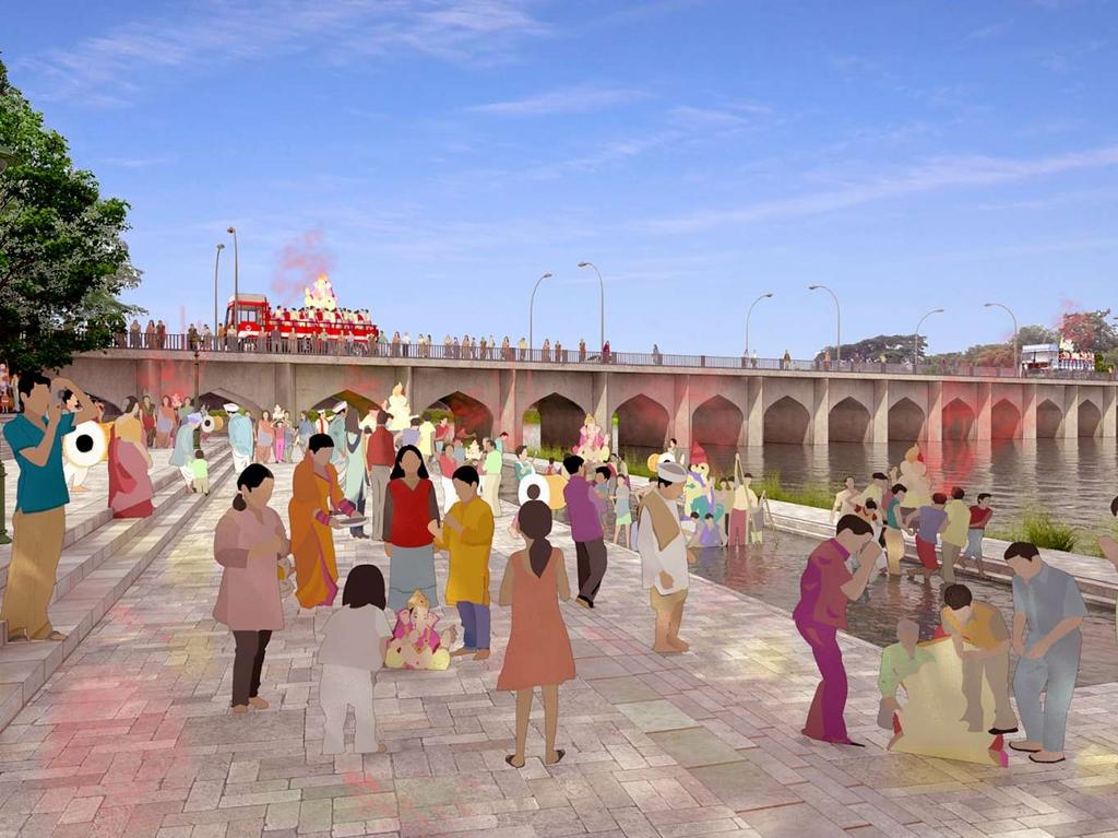
132
133 Pune River Rejuvenation Project Activating the Riverfront and Placemaking Proposed location for visarjan tanks Proposed visarjan tanks Figure 4.98: Map showing proposed visarjan tanks KM

134 Pune River Rejuvenation Project Activating the Riverfront and Placemaking Existing religious places along the river There are significant number of temples and dargahs along the river. Majority of the temples are along the Mutha River. They are not well accessed and the premises is not well designed. The proposal for river rejuvenation recognizes that these temples are nodes of public activity and when planned well coupled with plazas and space for gatherings can be used as important elements that can impart a sense of place, vibrancy and legibility to the riverfront. The master plan thus, proposes to enhance and integrate the surroundings of such landmarks and make it well accessible. Figure 4.99: Existing condition of the Omkareshwar temple complex showing compound wall, exposed sewer lines, and an inaccessible water edge.

135 Pune River Rejuvenation Project Activating the Riverfront and Placemaking Integrating religious places with the Master Plan The visualization of the area around Omkareshwar temple shown here illustrates the creation of such a space, submersible during monsoon and accessible during dry season. The design intervention includes restoring and enhancing the space around the temple, creation of plaza, redesigning the ghats, adding smooth curvilinear steps interrupted by circular and octagonal platforms leading to the river. The design endeavors to create a serene picturesque environment complementing the peaceful ambience of the temple. Figure 4.100: Integration of the existing temple with the proposed riverfront - redesigning the existing ghats and creating a plaza that is submersible during the monsoons.
136 Pune River Rejuvenation Project Activating the Riverfront and Placemaking Integrating existing gardens with the Master Plan Existing Gardens KM Figure 4.101: Map showing existing gardens which are to be integrated with the proposal Bund Garden, Botanical Garden, Sambhaji Baug, Vartak Garden, Nana Nani Udhyan, etc. are a few major existing gardens along the river which have been integrated in the Draft Master Plan. The total area of existing gardens is 82.45Ha.
137 Pune River Rejuvenation Project Activating the Riverfront and Placemaking Integrating existing gardens with the Master Plan There are some existing parks and gardens along the river like Sambhaji Baug, vartak garden, bund garden etc. It is essential to ensure seamless connectivity between proposed riverfront and these existing public gardens along the project. The master plan is carefully tailored to protect and enhance such public spaces. The existing condition disregards the presence of a water edge. The Master Plan aims at creating a continuous, accessible edge that seamlessly integrates various activities along the river like public parks, important buildings, structures of cultural or historic importance, kiosks, eateries, boating facilities etc. creating a pleasant and enjoyable environment. Existing red line Existing blue line River An attempt to integrate public parks existing along the river has been shown in Figure The gentle sloping, vegetated rural riparian embankment type has been proposed to merge with the garden. Botanical garden River Land Public land Existing Proposed red line Proposed blue line River Rural riparian Promenade Botanical garden River Land Public land Proposed Figure 4.102: Sections illustrating proposed embankment type for integrating existing parks and gardens

138 Pune River Rejuvenation Project Activating the Riverfront and Placemaking Existing gardens Pune River Rejuvenation Project aims at integrating all public land, infrastructure, important landmarks, public buildings, existing ghats, major streets with the riverfront. One such important landmark is Sambhaji Baug. The Baug, located on the banks of the Mutha river, is a well known recreational space in Pune with large and mature trees and stepped garden which partially submerges during monsoon. It is essential to integrate such an important landmark, consequently, enhancing the existing public space. Figure 4.103: Existing condition of Sambhaji garden along the river

139 Pune River Rejuvenation Project Activating the Riverfront and Placemaking Integrating existing gardens with the Master Plan The visualization below shows how the design proposes to integrate the Sambhaji Baug with the lower promenade. The design of the embankment is modified to correspond to the levels of the existing terraced garden. The design carefully retains existing trees and also, proposes additional green areas, promotes activities like boating and cycling, etc. Figure 4.104: Integration of Sambhaji garden with the proposed riverfront


140 Pune River Rejuvenation Project Activating the Riverfront and Placemaking Integrating existing activities with the Master Plan At present, there are few places along the river where eateries/ food stalls can be seen such as near Z bridge, bund garden, etc. Majority of these activities are on public land and within floodable area. It is essential to reorganize these activities in the riverfront development project. In our intervention we propose to accommodate existing activities like food courts, kiosks and further add markets, organized vending areas, craft bazaars, etc. This will activate the existing underutilized river bank as shown in the visualization (Figure 4.105). An existing bridge Baba Bhide bridge, which caters to two wheelers is to be removed, as it obstructs the flow of the water as per the hydrology and hydraulics study. A new pedestrian bridge has been proposed, with the soffit level of the bridge deck above the High Flood Level (HFL). This bridge shall link either sides of the river and make it conducive for pedestrians to cross. Existing condition Proposal Figure 4.105: Integration of existing food stalls under the Z bridge near Mutha river


141 Pune River Rejuvenation Project Activating the Riverfront and Placemaking Existing heritage structures There are many structures of historic importance especially along Mutha River owing to its proximity to the Old City area. These structures have been classified into three categories by Heritage Cell, PMC - Grade I, II, and III. Shanivarwada and Pataleshwar Caves are important heritage structures and fall under ASI listed monuments. There are in total 25 heritage structures along the three rivers. Shivaji Bridge Holkar Bridge on Mula River Shanivarwada Figure 4.106: Heritage structures along Pune s rivers

142 Pune River Rejuvenation Project Activating the Riverfront and Placemaking Integrating heritage structures with the Master Plan Enhancing existing historic structures along the river, is important for exponentially enriching the experience of the riverfront. The river is lined by historic retaining wall from Shinde Bridge to Dengale Bridge. Fig shows the existing condition in these areas with underutilized and inaccessible river edge lined by historic stone retaining wall. The river remains dry and has haphazardly laid infrastructure lines and manholes. Historic wall In such areas, the master plan proposes modification in the embankment design with wider lower promenades to accommodate the existing ghats and temples. Additionally, ghats, stretches of green, parks, cycle tracks, walkways and other public amenities are also provided as shown in Fig The materials of the embankment in this particular stretch will resonate with the existing historic walls and structures. Manholes Neglected bank Existing river Figure 4.107: Existing historic wall along Mutha river Proposed access to the riverfront Integration of existing historic wall Ghats Pitching Proposed river Figure 4.108: Proposal for integration of historic wall

143 Pune River Rejuvenation Project Activating the Riverfront and Placemaking Integrating heritage structures with the Master Plan The stretch illustrated on the right lies on the Mutha river, between the Dengale bridge and Shinde bridge. Historic character of the city is most evident in this stretch with its tall stone retaining walls on either side of the river, ghats, religious temples and samadhis. Being adjacent to the old city, this area also has cultural importance. This stretch is intensely active throughout the year owing to the same. Figure shows the channelized river with embankments designed as per the minimum width proposed by the hydrology studies and land availability respectively. The site analysis and review of the existing scenario demands a more context specific approach to designing this stretch- a proposal that integrates the existing scenario seamlessly and elevates the functional significance of the area. In line with the same principles, a conceptual sketch for the said stretch was drawn integrating the Shiv temple, Omkareshwar temple, existing ghats and the historic wall shown in Figure Figure 4.109: River width as per hydrology Integrating Shiv Temple & existing ghats Historic Wall Propose d Ghats Urban Riparian Embankment Integrating Omkareshwar Temple and Ghats Maharaja Shinde bridge Wider Lower Promenade Figure 4.110: Conceptual sketch showing embankment integrating the heritage structures Figure 4.111: Modified embankment integrating heritage structures

144 Pune River Rejuvenation Project Activating the Riverfront and Placemaking Integrating heritage structures with the Master Plan The riverfront development from Dengle Bridge to Shivaji Bridge has been modified considering all the existing structures, temples, activities and amenities like parks shown in Figure The riverfront promenades have been designed (made wider at many places to offer conducive space for congregation and performing arts) connecting all such locations of thriving activities and additionally new facilities have also been introduced. The design of elements like ghats, visarjan tanks, materials used for finishing, lighting scheme has been done bearing in mind all the religious and leisure activities linked to the river and their significance on festivals such as Ganesh Chaturthi and Anant Chaturdashi. On normal days this stretch would provide a peaceful and serene environment close to the water for people to sit, relax and connect with nature. Existing Heritage wall Huge manholes Narrow polluted water channel Underutilized banks Existing Ramp Figure 4.112: Existing condition of Mutha river, showing the existing historic wall, channelized river and manholes and open sewer lines flanking the river banks.

145 Pune River Rejuvenation Project Activating the Riverfront and Placemaking Integrating heritage structures with the Master Plan The river access and main ghats would also have provisions for tourist facilities, food stalls and public toilets. The design of the entire project took into consideration local architectural styles and language in order to preserve the character of the place. Ramps have been provided at regular intervals to ensure that the riverfront is universally accessible by all. Green areas Cycle track Ghats Clean retained water Boating facilities Pitching Lower level Promenade Access steps Integration of Historic wall Figure : Integration of the existing historic wall and design of a wider lower promenade, with recreational greens, cycle tracks, walkways and ghats merging seamlessly with the lower level pitching
146 Pune River Rejuvenation Project Activating the Riverfront and Placemaking Integrating heritage structures with the Master Plan The series of illustrations show the stretch between Shivaji bridge and Corporation bridge. The stretch is strategically located at the heart of the city, with a stone retaining wall along its length that protects the old city from floods. Adapting a context specific approach, the lower promenade has been widened in this stretch, with a series of ghats and plazas that step up to meet the historic wall. The promenade has been designed to accommodate elements that promote multifarious functions and activities, ranging from visarjan ghats and steps, platforms that puncture the steps at regular intervals for seating and ritual purposes, walkways, and green recreational stretches. Textures, steps, platforms, vegetation, etc. elements are repeated in regular intervals for aesthetic appeal. Moreover, a design palette of materials and textures have been adopted that responds to the existing retaining wall. Extensive articulated ghats Corporation bridge Existing retaining wall Underutilized banks Existing river Various alternatives have been worked out in relation to the mentioned principles, as illustrated below. Shivaji Bridge Figure 4.101: The illustration above shows the existing condition of the mentioned stretch wherein the banks lie barren and underutilized. Corporation bridge Existing retaining wall Extensive articulated ghats Retained water Corporation bridge Existing retaining wall Visarjan tank Ghats Retained water Shivaji Bridge Shivaji Bridge In this design option, extensive articulated ghats have been sought throughout, reflecting the character of Pune s Ganesh Visarjan ghats. In this design option, visarjan tanks have been accommodated into the lower embankment, merging with the ghats on either side. Figure 4.114: The illustrations shows the alternative design proposals for activating the river edge

147 Pune River Rejuvenation Project 147 Corporation bridge Corporation bridge Existing retaining wall Wider promenade Ghats Existing retaining wall Walkway with greens Ghats Retained water Retained water Shivaji Bridge Shivaji Bridge In this design option, the lower promenade has been leveled out to provide an unobstructed and continuous public space that can accommodate various events and activities. In this design option, to reduce the amount of hardscape and introduce more greenery while maintaining a continuous flow of space, the lower promenade has been designed introducing green stretches and parks at regular intervals. Ghats are provided along the pitching into the river to accommodate the functions of visarjan etc, along with other recreational activities.

148 Pune River Rejuvenation Project Activating the Riverfront and Placemaking Existing heritage structures The photograph shows the area near Shivaji Bridge. Number of structures like Shivaji Bridge, an old retaining wall and Ghorpade Ghat characterize this place as area of great historic and cultural significance. Even though the river is accessible by ramps and ghats, this stretch remains in a state of dismay and disrepair. Haphazardly built manholes and infrastructural lines can be seen. The riverbank remains underutilized and poorly maintained. Figure 4.115: Existing condition near Shivaji bridge

149 Pune River Rejuvenation Project Activating the Riverfront and Placemaking Integrating existing heritage structures with the Master Plan The visualization of the area near Shivaji bridge illustrates the Master Plan strategy to integrate structures of cultural and historic importance. The Master Plan captures the essence of the place and cherishes these structures. To accommodate the existing trees and the structures, the embankment design is modified as per requirement on site. To make the river more accessible to public, ramps, ghats and access steps have been proposed. The lower promenade here is wider and accommodates jogging and cycling tracks, walking paths, green areas, and well articulated ghats. The lower level pitching adds to the green cover. The design enhances the overall environment and captures the spirit of the city. Figure 4.116: Proposal integrating heritage wall near, and creating activity areas as per context


150 Pune River Rejuvenation Project Activating the Riverfront and Placemaking Recreational facilities - Boating Barrages proposed will also ensure that the water level is sufficiently deep, most times of the year. This would enable us to introduce boating as a leisure activity. Also, more activities like vendor spaces and eateries, immersion tanks for Visarjan and religious activities, well developed ghats, etc. have been proposed thus, making the riverfront more vibrant. Effective use of public land Public green spaces Continuous pedestrian & cycle tracks Figure 4.118: Continuous public realm with boating and other recreational facilities Parking signage, light pole facilities Access up to water Integrating and improving existing ghat locations Water-based activities Clean retained water Figure 4.117: Proposed boating routes Figure 4.119: Proposed boating facilities along Pune s rivers
151 Pune River Rejuvenation Project Activating the Riverfront and Placemaking Proposed boating facilities Proposed Jetty Figure 4.120: Map showing proposed boating facilities KM


152 Pune River Rejuvenation Project Land Management Strategy The master plan proposals for the river rejuvenation project have been formulated for the river land as demarcated by the land records department. However, at some locations some residual spaces are formed whose ownership needs to be known or their use should be defined so that this surrounding land complements and corresponds to the development on the riverfront in these areas. One such area along the Mula-Mutha river has been shown in Figure The river land as per land records has been shown in black line. In this case a road has been constructed along the river land boundary as shown. A thin sliver of land is left between the road and the river land boundary. Such spaces should not be left unattended- some use or function need be recommended for these parcels, such that they complement the riverfront activities ensuring better integration of the surrounding context with the river. Adjacent plot boundaries and demarcated river land boundary as per approved maps from Land Records Department, Pune Plot boundaries and total station survey Plots and river land boundary superimposed on satellite image show the thin sliver of land between the river land boundary and existing road, Some use or function should be recommended for such residual spaces that complement and correspond to the river rejuvenation project. Master Plan Figure 4.121: Strategy for residual land along the riverfront development


153 Pune River Rejuvenation Project Land Management Strategy It is essential to integrate the available public land parcels adjacent to the river with the riverfront development. This public land can be used to create amenities and recreational facilities for the people. Also, it can be used as potential source of revenue generation. One such example of public land is the Botanical garden situated on the banks of Mula River has been shown in Figure The Botanical garden is a well developed park and has been integrated with the riverfront project. The riverfront aims to seamlessly integrate such existing gardens, public parks, amenities, thus, making the riverfront viable, vibrant and dynamic public space. Adjacent plot boundaries and demarcated river land boundary as per approved maps from Land Records Department, Pune Plot boundaries and total station survey Plots and river land boundary superimposed on satellite image Integration of the existing Botanical garden with the proposed master plan Figure 4.122: Strategy for integrating available public land parcels with the riverfront development

154 Pune River Rejuvenation Project 154

. Here, the river land boundary (black line) suggests otherwise.")


155 Pune River Rejuvenation Project Land Management Strategy At some locations even though the land records show a certain river land boundary, but, the same need to correspond to the existing situation on the ground to formulate context specific, more functional design solutions. For example- The river stretch near the railway bridge shown in Figure is lined by an existing retaining wall (shown in brown). Here, the river land boundary (black line) suggests otherwise. In such cases, the master plan deliberately chooses to integrate the land up to the retaining wall in its proposal as on ground the retaining wall acts as the demarcation between river land and adjacent private properties. Adjacent plot boundaries and demarcated river land boundary as per approved maps from Land Records Department, Pune Plot boundaries and total station survey, highlighting the retaining wall on the left bank of the river Plots and river land boundary superimposed on satellite image As on ground the retaining wall marks the boundary of the river and is an accepted fact for years, the same has been considered as the project boundary for the master plan proposals Figure 4.123: Defining project boundary based on existing retaining walls that at present demarcates river land on site


 is public land.")
156 Pune River Rejuvenation Project Land Management Strategy Naik bet is a densely vegetated riverine island situated on the Mula Mutha river. As per the master Plan, flood protection embankments have been proposed for the island as well. As per the information received from land records department, this island is not public land. However, due to its strategic location owing to the proximity to Bund Garden barrage, which will keep the water retained in the river and bridges proposed in development plan that will ensure connectivity to the island, it has great potential of elevated into a city level recreational space and eco-sensitive area. Naik Bet Naik Bet Adjacent plot boundaries, demarcated river land boundary as per approved maps from Land Records Department, Pune and Naik Bet Plots and river land boundary superimposed on satellite image Alternative 1:. The land reclaimed between the two riverine islands (once flood mitigation protection embankments are built) is public land. To utilize this land effectively, the reconstitution of Naik Bet can be done as shown in the illustration here such that the public land is at one end of the island this area can then be easily converted to a meaningful public and recreational space connected by bridges to the bank of the river. Alternative 2: Another alternative way of reorganizing/ reconstituting the island has been shown here. In lieu of the flood protection works being carried out for the island some more land can be taken. This along with the public land reclaimed between the two riverine islands can then be distributed all along the edge of the island, thus forming a continuous public realm along the proposed flood protection embankments and private property inside. Alternative 3: As Naik Bet is a densely vegetated riverine island, another alternative strategy to ensure the protection of this eco sensitive area is to covert the entire island to a protected public land with public access in future. Figure 4.124: Strategy for integrating the Naik bet partially or wholly in the master plan proposal in order to elevate its ecological importance

157 Pune River Rejuvenation Project Land Management Strategy Land Appropriation After constructing the proposed embankment the remaining public land up to the private property can be developed for public purpose. However, this remaining land is irregular in shape as per site condition of adjacent property line. This has to be appropriated to facilitate optimal utilization of the land parcels for developing various amenities, utilities and facilities, etc. essential to the riverfront project. No. Plot No. Give (sqm) Take (sqm) 1 Plot No Plot No Plot No TOTAL: Table 4.5: Amount of land acquired and compensated in the process of Land Appropriation Figure 4.125: Remaining land along the river Usable parcels of land Land given Land acquired Figure 4.126: Appropriation and straightening of Remaining land along the river
158 Pune River Rejuvenation Project Design Programme The Design Programme for Pune River Rejuvenation project has been carefully crafted to achieve the aforesaid objectives of the project. Primarily the project aims at providing the following- Vision Safe Clean Objectives 1. Reduce risk of Flooding 2. Clean the river and make it pollution free Design Programme Removal of obstacles Flood protection embankments Sewerage network Sewage treatment plant Tertiary treatment facility Storm water network Solid waster disposal
159 Pune River Rejuvenation Project 159 Rejuvenate Integrate 3. Retain and Replenish water 4. Create a continuous public realm 5. Conserve and enhance heritage structures 6. Integrate existing parks, gardens and amenities Water retention structures Riverfront Parks and Gardens Open Ground Urban Forest Event Spaces Market Spaces Craft Bazaar Public plazas Promenade Walking Trails Biking Trails Proposed bridges Pedestrian bridges Access steps and ramps Food Court Parking Dhobi Ghat Ghats Visarjan Tanks Integration of existing temples Toilets Electrical sub-station
160 160 This page is intentionally left blank
161 Pune River Rejuvenation Project 05 Master Plan This section briefly illustrates the key factors and major objectives taken into consideration while envisioning the project. 5.1 Project Area 5.2 Embankment 5.3 Land use 5.4 Bridges 5.5 Traffic Management 5.6 Landscape Strategy 5.7 Urban Elements 5.8 Lighting and Electrification 5.9 Material Palette

162 Pune River Rejuvenation Project Project Area This chapter elaborates on the final master plan and its components in detail. The design program and concepts formulated prior has been materialized into the finalization of the master plan as elaborated further. It is required to design the waterfront project so as to ensure that the land is used for purposes of development of planned green and open space for recreational uses by the citizens. Also, the riverfront has been designed considering the provisions for components such as flood protection and bank erosion prevention measures, curbing outfalls, capture waste water and re-use after bio-filtration of drains, Ganesh festival celebration points, bicycle track, jogging track, kids playing areas, amphitheatres, forestation on large scale, organized vending spaces, parking, infrastructure for safety and monitoring of the premises, urban design elements and integration with road network to ensure access from preferred locations, etc. The following section shows the demarcated river land boundary as per land records and the proposed river section as per hydrology. Subsequently, the Master Pan has been illustrated highlighting the different types of embankment conceptualized, and the land use proposed, post a final assessment of the remaining land after design on embankments and further acquisition required. The approved maps from various Land Records departments were combined and the final river land boundary was derived. The same has been shown on the adjoining page. The total river land area as per this boundary is 687 ha.
163 Pune River Rejuvenation Project Project Area River land 687 ha Figure 5.1: Map showing River land KM
, a center line is established and minimum width of the rivers as per Hydrology and Hydraulics is defined.")
164 Pune River Rejuvenation Project Project Area River section As already explained in the previous chapter (4.1 Flood Protection Measures), a center line is established and minimum width of the rivers as per Hydrology and Hydraulics is defined. The map on the adjoining page shows the alignment and width of Mula, Mutha and Mutha River in consonance with the Hydrology and Hydraulic Studies. Also in some stretches, the river has been widened where land was available or to suit on site conditions for example- the area near bund garden has existing pitching on site (river stabilization works conducted earlier). As the land is also available, hence the existing pitching can be utilized as part of the proposed rural riparian embankments and the river width can be increased in this stretch as shown in figure 5.3. Figure 5.2: River Channel as per Minimum Width suggested by Hydraulic Studies - Mula River Figure 5.3: River Widening- Mula-Mutha River
165 Pune River Rejuvenation Project Project Area River section 526 Ha Figure 5.4: Map showing channelized river boundary KM
, as has been discussed in the previous sections. The map on the adjoining page (Figure 5.")


166 Pune River Rejuvenation Project Embankment Embankment type The master plan details out five types of embankments (Figure 5.5, 5.6, 5.7, 5.8, 5.9), as has been discussed in the previous sections. The map on the adjoining page (Figure 5.10) shows the various type of embankments along the 88km of river length. The embankment types have been proposed considering the land availability and the surrounding context. Also, a conscious effort has been made to make provision for more greener embankments (Rural and Urban Riparian Embankment design) vis a vis Engineered Section. Consequently, approximately 79% of the river length has rural and urban riparian embankments. These embankment types will add to the green cover of the city, thus, improving its environmental health. The engineered section has been used only where land availability is scarce. Upper Level Promenade HFL Figure 5.5 : Rural Riparian Embankment with slope 1:3 Figure 5.6: Urban riparian I - Embankment with slope 1:2 PWL Upper Level Promenade HFL Lower Level Promenade PWL Rural Riparian Urban Riparian Engineered Section 37% 42% 21% Total length of embankments: 92 km Upper Level Promenade HFL Lower Level Promenade PWL Upper Level Promenade HFL Lower Level Promenade PWL Figure 5.7: Urban Riparian II - Sloped Embankment with lower level retaining wall Figure 5.8: Urban Riparian III - Sloped Embankment with upper level retaining wall Upper Level Promenade HFL Lower Level Promenade PWL Figure 5.9: Engineered Embankment with rectangular cross-section
167 Pune River Rejuvenation Project Embankment Embankments 180 Ha Figure 5.10: Map showing embankment types Rural riparian Urban riparian I Urban riparian II Urban riparian III Engineer section KM

168 Pune River Rejuvenation Project Embankment Area Acquired for embankment continuity In some stretches, the river land available is inadequate for ensuring the minimum width of the river water as per the hydrology and hydraulics study and building embankments. In such cases, owing to the need of flood protection, some land will be acquired so as to construct continuous embankments along the river, as illustrated in Figure The minimum land that is to be acquired to ensure continuous embankments has been shown in red in Figure Approximately 81 Ha of land will acquired for the same. Baltangwadi Holakar Bridge Land to be acquired Figure 5.11: Image showing the land to be acquired for building of embankments
169 Pune River Rejuvenation Project Embankment Area Acquired for embankment continuity 81 Ha Land to be acquired Figure 5.12: Map showing land acquisition KM

170 Pune River Rejuvenation Project Land use Balance land for Public Amenities The Public land available, as shown in figure 5.13 and 5.14, after building flood protection embankments, can be utilized for suitable public recreational activities. The land is above the HFL, therefore they are protected areas from the floods. However looking at the context and availability of land these parcels are broadly identified as public greens. Nilanjali Society Koregaon Park Remaining land Figure 5.13: Image showing public amenities
171 Pune River Rejuvenation Project Land use Balance land for Public Amenities 62Ha Figure 5.14: Map showing remaining land in the project boundary Remaining land KM

172 Pune River Rejuvenation Project Land use Proposed Land use The majority of river land i.e. 64% public land is under proposed river width and 19% under proposed types of flood protection embankments. However, the 17% remaining s divided into various activities as shown in Figure The total remaining public land is identified for various uses as shown in Figure 5.15 and Primarily the remaining land has been distributed into three main categories Nilanjali Society Public greens This will include parks and gardens, open grounds and urban forests. It will contribute and add to the existing green cover of the city. Public amenities and Utilities This will include amenities such as temple ghats, visarjan facilities, parking areas, dhobi ghat, public plazas and food courts. Public amenities will ensure that the proposed riverfront is active, vibrant, viable and dynamic. Also, utilities like electric substations, pumping stations, toilets, drinking water facility etc. is also proposed along the riverfront. Of the land remaining, 74% is under public greens and 26% caters to public utilities and amenities. Koregaon Park Figure 5.15: Image showing proposed land use along the river 26% 19% 17% 64% 74% Gardens/Urban Forest/Open grounds Amenities Garden Urban forest Open ground Temple ghat Ganesh visarjan Parking Dhobi ghat Plaza Food court Crematorium Channelised River Remaining Land Embankment Figure 5.16 : Pie chart showing the division of land used for various requirements
173 Pune River Rejuvenation Project Land use Proposed Land use Figure 5.17: Map showing public amenities Garden Urban forest Open ground Temple ghat Ganesh visarjan Parking Dhobi ghat Plaza Food court Crematorium KM


174 Pune River Rejuvenation Project Land use Proposed Land use green cover The Master Plan consists of a green network of parks, open spaces, urban forests and public promenades that will preserve the natural environment and create important asset for the city. Different kind of green public spaces have been proposed along the entire stretch of the waterfront so that there is wider public accessibility and spread of benefits and will add to the versatility of the public place. The proposed green network shall support and enhance the existing natural environment of the River. Based on the land availability and contextual significance green spaces are divided into following categories: Urban forests Parks and gardens Open grounds Pathway Figure 5.18: Strategy for Urban forests Tree cover Urban Forest Figure 5.19: Example of urban forest in Portland, Oregon Parking Recreational green Landscaped area Plaza Pathway Figure 5.20 : Strategy for parks and gardens Figure 5.21: Example of riverfront park: Hornsbergs Strandpark, Stockholm, Sweden Pathway Parking Buffer green Play area Green Figure 5.22: Strategy for open spaces Figure 5.23: Example of open grounds: Corregidor Island, Philippines
175 Pune River Rejuvenation Project Land use Proposed Land use - Gardens, Urban Forest and Open ground Figure 5.24: Map showing proposed land use with green cover Garden Urban forest Open ground KM


176 Pune River Rejuvenation Project Land use Public Amenities Many public amenities like food courts, kiosks, public plazas, organized outdoor vending areas, craft bazaars, open grounds for events etc., are proposed all along the length of the project. Ghats and jetties have been proposed for recreational purpose. Adequate parking provisions have been made in the master plan to support these activities on the riverfront. The master plan proposes to develop a walkable waterfront with such public amenities, making the riverfront a viable, vibrant and dynamic public space. Figure 5.25: View from the upper promenade Figure 5.26: View from the lower promenade
177 Pune River Rejuvenation Project Land use Balance land for Public Amenities 62Ha Figure 5.27: Map showing proposed land use with public amenities Temple ghat Ganesh visarjan Parking Dhobi ghat Plaza Food court Crematorium KM


178 Pune River Rejuvenation Project Bridges Existing bridges In total there are 34 bridges across the river length. Maximum bridges are seen across the Mutha River. There are fewer number of bridges across Mula and Mula-Mutha River. There are some places where adjacent bridges are very far from each other, resulting in longer trip length and time delay. Therefore, it is essential to add some new bridges to facilitate travel across the river and reduce the longer trips and time delay. Maharshi Shinde Bridge- Mutha River Shivaji Bridge- Mutha River Kakasaheb Gadgil Bridge (Z Bridge)- Mutha River New Yerwada Bridge- Mula-Mutha River Figure 5.28: Existing bridges of Pune
179 Pune River Rejuvenation Project Bridges Existing bridges Vehicular Bridge Railway Bridge Pedestrian Bridge 2-Wheeler Bridge Figure 5.29: Map showing exiting bridges In total there are 34bridges across the river length. Maximum bridges are seen across the Mutha River. There are fewer number of bridges across Mula and Mula-Mutha River. There are some places where adjacent bridges are very far from each other, resulting in longer trip length and time delay KM
180 Pune River Rejuvenation Project Bridges Bridges Proposed There are few very low lying Bridges, Causeway with restricted opening that pose obstruction to the water flow, and gets submerged during the flood, create afflux or rise in water level in the upstream of the river. In some cases the high flood level is above the soffit of the bridge and sometimes also overtops the deck slab of the bridge. The master plan proposes the lifting of such bridges as per hydraulics, in addition to proposing new bridges. The parameters for the same have been elaborated below: Bulky bridge columns Sleek and slender bridge columns Location of the bridges The location of the bridges have been decided based on the existing road network. This ensures seamless and smooth integration with the existing road network. These bridges have also been proposed so that there are not long stretches along the river which lack connectivity i.e. ensure accessibility all along the riverfront. Parameters for Bridge Design To enhance and strengthen the connectivity across the river, few bridges have been proposed within the Pune River Rejuvenation Project apart from proposed bridge in Development Plan. Design of the Pier An important consideration in the design of bridges is to ensure that the structure of the pier does not obstruct the smooth flow of water. Thus sleeker piers are sought as opposed to bulky columns in the proposal, as illustrated in Figure Moreover, it is viable to design the piers in a manner such that its placement does not hinder the continuity of the promenades (Figure 5.30). The piers hinder the continuity of the promenades The placement of the piers is such that it does not hinder the continuity of the promenades Soffit Level of the bridge deck above the upper walkway Soffit level of the bridge above the river is defined with respect to 100 year HFL. As per IS Code soffit of deck slab should be minimum 1.5m above HFL (Figure 5.31). Figure 5.30: Designs of piers Soffit level of the bridge A traffic management scenario has to be taken into consideration during the revision in existing bridges, or wherever required. HFL 1.5 M min Bridge piers Figure 5.31: Image showing the soffit level of the bridge
181 Pune River Rejuvenation Project Bridges Bridges Proposed Mula Existing Bridges DP Proposed Bridge Up gradation of Bridges Lifting of Bridges as per hydraulic study Proposed pedestrian bridges Proposed Bridge KM Figure 5.32: Map showing proposed bridges In order to ensure connectivity across the river, Development Plan has proposed 7 bridges as shown in the map. However, some of the existing bridges need to be improved / upgraded as shown in green, whereas Draft Master Plan also proposes 3 bridges to ease the across connectivity. The proposed bridges shall consider the proposed HFL while designing the bridge height.


 Low-lying road")
182 Pune River Rejuvenation Project Traffic Management Roads to be Removed & Strengthened To construct the flood protection embankment, existing low-lying streets, as shown in Figure 5.33, need to be removed. In order to ensure the connectivity, the alternate parallel streets shall be strengthened. Traffic management on the existing roads will have to be done for them to be strengthened. Low-lying River side road along Mutha River Low-lying Road along Mutha River (August, 2016) Low-lying road getting submerged during monsoon along Mutha River near Omkareshwar Temple (August, 2016) Figure 5.33: Existing low lying roads abutting Pune s rivers

183 Pune River Rejuvenation Project Traffic Management Roads to be Removed & Strengthened Figure 5.34: Map showing existing roads to be removed To construct the flood protection embankment, existing low-lying streets need to be removed. In order to ensure the connectivity, the alternate parallel streets shall be strengthened Roads to be Removed Roads to be Strengthened Existing Road network Roads outside Project Boundary KM
184 Pune River Rejuvenation Project Landscape Strategy Planting Palette Urban and Rural Riparian Embankment Landscape Context In case of sparsely developed areas and ample availability of public land, the river flood protection work can be done through minimal intervention, enhancing existing riparian edges (that also allows vegetation to grow over the surface), termed as Rural Riparian Embankment. There are 5 key planting components that have to work in alignment to preserve the integrity of the embankment, as illustrated in Figure 5.35: They are: 1. Tall grass near the river bed 2. Grass on the pitching (slope- 1:3) 3. Shrubs at the junction of promenade and pitching 4. Trees on the pitching (slope- 1:3) preferably along trails 5. Tree line along the upper promenade and lower promenade Landscape Objective The landscape in this section faces the following challenges: 1. The edge along the riverbed is critical to the stability of the embankment. It will have conditions ranging from no water to high velocity flood water. A strong rhizome root system and a plant type capable of surviving extreme water regimes is required 2. The ground cover on the sloped embankment should have species that can withstand high flood levels and the erosive power of the water. 3. The tree species on the sloped embankment should have penetrative root system that anchors the sloped soil at deeper levels. The trees should be vigorous enough to compete well with the ground cover on the slope.. 4. The shrubs along the junction of the promenade and sloped pitching should be hardy, requiring very little maintenance and aesthetically appealing. 5. The trees along the promenade should be hardy, mostly evergreen, with some flowering species. River basin Pitching Upper Promenade 1. Tall grass near the river bed 2. Grass on the pitching (slope- 1:3) 3. Shrubs at the junction of promenade and pitching 4. Trees on the pitching (slope- 1:3) preferably along trails 5. Tree line along the upper promenade and lower promenade Figure 5.35: Schematic cross section showing planting strategy in Rural riparian embankment

.")

185 Pune River Rejuvenation Project Landscape Strategy Planting Palette Urban and Rural Riparian Embankment 1. Tall grass near the river bed: The interface between the sloped edge and the flat riverbed is where scouring can occur if proper protection is not given to the soil. This scouring can cut below the sloped embankment an create structural instability. The moisture regimes in this interface can vary between extremes. It can be bone dry in summer and have water flowing at high velocity in the monsoon season. There are a few native species that are eminently suitable for planting in this interface (Figure 5.36). The following species are presented as representative palette. a. Saccharum spontaneum This is a very hardy, and abundant native grass that is easily available and need little care once it is established. It have a very robust rhizomatous root system that will survive extreme drought. Its fibrous root system imparts tremendous structural stability to this critical interface. It will grow between boulders and, once established, will hold the boulders in place during floods. This species is very easy to source, establish and has the added advantage that it seeds profusely and multiplies itself naturally. It is a preferred habitat for nesting among many bird species. b. Persicaria glabra This is a very hardy, and abundant native herb that is easily available and need little care once it is established.it is widely found in the Pune area. It has a vigorous root system that anchors the soil. It provides an excellent habitat for fish and turtles. Its flowers attract lot of pollinator insects. Saccharum Spontaneum c. Crinium viviparum This attractive lily is a wild species found along water edges throughout the Deccan plateau. It has a large underground bulb that stores abundant food to tide over harsh weather conditions. In fact, this is one plant that will not die even when faced with five continuous years of drought. It provides a robust root system that anchors the soil. It will not be eaten by sheep and cows. It provides excellent habitat for larger fish and animals in the littoral zone. It has attractive white flowers that attract pollinators. Persicaria Glabra Crinium Viviparum Figure 5.36: Species of tall grasses that can be used in the Rural Riparian embankment
 The sloped embankment will be freshly constructed in the project and stabilizing the slope will the key to")


. Vetiver has one of the best rooting system in the entire plant kingdom. It is easy to establish and need very little care or maintenance.")
186 Pune River Rejuvenation Project Landscape Strategy Planting Palette - Urban and Rural Riparian Embankment 2. Grass on the pitching (slope- 1:3 and 1:2) The sloped embankment will be freshly constructed in the project and stabilizing the slope will the key to the success of the project. One species of grass that has had extensive success in stabilizing slopes for river banks is Vetiveria Zizanioides, commonly know as Vetiver Grass (Figure 5.37). It has succes worldwide and now regularly specified in World Bank projects. Vetiveria Zizanioides is the only grass that fits all the plantation requirements for the riparian edges. The World Bank had been actively promoting vetiver as a grass that would help conserve soil (erosion control) and water (runoff retention/more infiltration). Vetiver has one of the best rooting system in the entire plant kingdom. It is easy to establish and need very little care or maintenance. At the end of the flowering period, the spikes are harvested by the locals to make thatch and brooms. Vetiver Grass in just 90 days after planting Vetiver Fibrous Root Mesh Vetiver root length Figure 5.37: Species of grasses that can be used in the Rural and Urban Riparian embankments


187 Pune River Rejuvenation Project Landscape Strategy Planting Palette - Rural Riparian Embankment 3. Tall trees on the pitching : Apart from the Vetiver grass on the pitching slope, it requires carefully selected larger trees to be planted for the anchoring of the soil at deeper levels. It is the landscape intent for this project that local indigenous tree species be used also that have economic or medicinal value. This will encourage the local to look after these trees so that their produce can be used by themselves. This will allow for the participation, and therefore a sense of ownership among the locals, which will greatly add to their maintenance and survival. There are a few native species that are eminently suitable for planting on this sloped embankment (Figure 5.38). The following species are presented as representative palette. a. Stereospermum colais This is a very hardy, native tree ( padal in marathi) that is easily available and needs little care once it is established. It have a very robust root system that will survive extreme drought as well as water logging. It grows to the height of mts and sports beautiful yellow flowers in spring. Root bark is one of the constituents of Dashmula preparation used as tonic, diuretic. Root is antiinflammatory, anti-asthmatic, antiemetic and febrifuge. It is biliary, stimulant, of cardio-tonic, diuretic and used in piles and nervous disorders. b. Semecarpus anacardium Another native tree that is easily available in the forests and is widely found in the Pune area. Known as Bibba in marathi, the dye from its nuts are traditionally used by washer men to mark clothes because its ink is not water soluble. It has a vigorous root system that hold the soil well. It grows to the height of mts.it has high priority and applicability in indigenous system of medicine, and is well-known for its medicinal value in Ayurvedic and Siddha system of medicine. Syzygium Caryophyllatum b. Syzygium caryophyllatum This is the wild Jamoon tree that is native to the Pune region. It grows to the height of mts and is efficient in controlling soil erosion due to its robust root system. The tree is found on river banks in the wild. It is evergreen and produces black berries that have many medicinal properties for treating indigestion. It seeds are effective in regulating diabetes. Its leaves help in absorption of Vitamin E and reduces gum inflammation. Its bark is used controlling diarrhea. Semecarpus Anacardium Stereospermum Colais Figure 5.38: Species of tall trees that can be planted on the Rural Riparian slope


188 Pune River Rejuvenation Project Landscape Strategy Planting Palette - Rural Riparian Embankment 4. Shrubs at the junction of promenade and pitching: The upper edge of the interface of the promenade with the sloped pitching will always be above the high flood level, and erosion by the river is not in play here. Therefore, apart form the selection criteria for a good root system, some leeway can be given to introduce color in the palette. One such shrub that is very low maintenance but extremely colorful in summer is the Bougainvillea species. It has a vigorous root system and can be trimmed to heights ranging from 0.5 to 2.0 mts. It is very drought tolerant, and in summer, the less water it gets, the more the flowers it will produce. The following species of Bougainvillea (Figure 5.39) are presented as representative palette. a. Bougainvillea Purple This is a very hardy, is easily available and needs little care once it is established. It have a very robust root system that will survive extreme drought. It can be trimmed to the height of 0.5 to 2.0 mts and sports beautiful purple flowers in spring. b. Bougainvillea Orange King This is a very hardy, is easily available and need little care once it is established. It have a very robust root system that will survive extreme drought. It can be trimmed to the height of 0.5 to 2.0 mts and sports beautiful orange flowers in spring. c. Bougainvillea Yellow California Gold This is a very hardy, is easily available and need little care once it is established. It have a very robust root system that will survive extreme drought. It can be trimmed to the height of 0.5 to 2.0 mts and sports beautiful yellow flowers in spring. Bougainvillea Purple Bougainvillea Orange King d. Bougainvillea Pink Barbara Karst This is a very hardy, is easily available and need little care once it is established. It have a very robust root system that will survive extreme drought. It can be trimmed to the height of 0.5 to 2.0 mts and sports beautiful pink flowers in spring. Bougainvillea Yellow California Gold Bougainvillea Pink Barbara Karst Figure 5.39: Species of shrubs that can be planted at the junction of promenade and pitching


.")

189 Pune River Rejuvenation Project Landscape Strategy Planting Palette All embankments types 5. Lower Promenade Trees Landscape Context The Lower Promenade allows the user to experience the riverfront from the closest quarter. The hardscape in the paving can result in creating heat islands making the experience uncomfortable. Therefore, the creation of shaded spaces assumes priority. Street furniture, including benches for users to sit and view the riverfront, are incorporated for enhanced user experience. Landscape Objective The trees must provide shade suitable for walking and seating. The tree canopies should be of a spreading habit, and the canopy height and volume must not overwhelm the river embankment. The intention is to create a green canopy that has a similar volume and growth rate throughout the avenue. Planting Palette Pune city already boasts of a wide range of indigenous plant species (390 species all around the city). The plant species to be used on the lower promenade will thus be selected from these native species. The species will medium trees that will grow to a maximum height of 6 to 8 m, having a spreading canopy of 3 to 4 m. The species are mostly evergreen throughout the year. The leaf fall is generally occurring in the peak winter months when filtered sunshine is welcome to the user. A representative planting is show here alongside (Figure 5.40) as reference. Chrysophyllum Cainito Tree Canopy height 6-8 mts Canopy dia. 4-5mts Cochlospermum Religiosum Tree Canopy height 6-8 mts Canopy dia. 4-5mts Planting Plan for Lower Promenade The positioning and spacing of the trees is determined by type of embankment. The lower promenade is typically 6m wide. The trees will be placed eccentrically maintaining a distance of 2m (incase of retaining wall connecting upper and lower promenade) and 1m (incase of sloped embankment connecting upper and lower promenade) between the tree trunk and edge of embankment. Spacing for trees in the Lower walkway is 4 to 6m c/c.there will be 3 trees between light poles that are 12m c/c. Azadirachta IndicaTree Canopy height 6-8 mts Canopy dia. 4-5mts Cananga OdorataTree Canopy height 6-8 mts Canopy dia. 4-5mts 1 m 5 6 m 1 m 5 6 m Upper Promenade Lower Promenade Upper Promenade Sloped Embankment Lower Promenade Engineered Section Urban Riparian embankment Figure: Diagrams showing placement of trees Cananga odorata Tree Canopy height 6-8 mts Canopy dia. 4-5mts Figure 5.40: Species of tall trees that can be planted on the Lower promenade Plumeria rubratree Canopy height 6-8 mts Canopy dia. 4-5mts


190 Pune River Rejuvenation Project Landscape Strategy Planting Palette - All embankments types 5.Upper Promenade Treea Landscape Context The Upper Promenade provides scenic vistas all along the waterfront for the users. It provides entry to the river ghats that access the lower promenade. Tree plantation is required all along the promenade to continue the character of the existing river edge lined with dense vegetation. There will be seating benches, dustbins, lights to further enrich the user experience. Landscape Objective The tree plantation should be iconic as the Upper Promenade has high visibility from either riverbank. The tree plantation should be such that the access points to the lower promenade should get defined clearly. The intention is to create a green canopy that has a similar volume and growth rate throughout the avenue. Planting Palette The tree species will be chosen from the existing list of exhaustive trees native to Pune city. The upper walk will have large trees that will grow to a maximum height of 10 to 15 m, having a spreading canopy of 6 to 12 m. The tree palette has been selected such that, combination of pairs of tree canopies are similar, and having similar growth rates. A representative planting is show here alongside (Figure 5.41) as reference. Mangifera IndicaTree Canopy height mts Canopy dia. 6-8mts Pongamia pinnata Tree Canopy height mts Canopy dia. 6-8mts Planting Plan for Upper Promenade The positioning and spacing of the trees is determined by the positions of the various points at which the upper promenade is accessed. The upper promenade is typically 6m wide. The trees will be placed eccentrically maintaining a distance of 1m between the tree trunk and the outer edge of the promenade. Spacing for trees in the Upper promenade is 6m c/c. There will be 2 trees between successive light poles spaced 12m c/c. Peltophorum Pterocarpum Tree Canopy height mts Canopy dia. 6-8mts Samanea saman Tree Canopy height mts Canopy dia. 6-8mts 1 m 5 6 m 1 m 5 6 m Upper Promenade Lower Promenade Upper Promenade Sloped Embankment Lower Promenade Engineered Section Figure: Diagrams showing placement of trees Urban Riparian and Rural Riparian embankment Dolichandrone Spathacea Tree Canopy height mts Canopy dia. 6-8mts Figure 5.41: Species of tall trees that can be planted on the Upper promenade Ficus religiosatree Canopy height mts Canopy dia. 6-8mts


191 Pune River Rejuvenation Project Landscape Strategy Urban Forests Landscape Context During the process of river training in the urban context, certain pockets of reclaimed land emerge between the walkway and the existing urban edge. These are envisioned as urban forests, providing the city with the much needed lung spaces. The feel of green spaces would be to invoke the feeling of wilderness alongside the waterfront. These areas will serve to attract birds and other fauna. Pathway Tree cover Urban Forest Landscape Objective The landscape in this section attempts to recreate the Forest Wilderness: 1. To populate the area in a informal planting layout with trees. 2. To use extensively local indigenous trees. 3. To carefully design the layout so as to create multiple layers of tree canopy that seamlessly create super canopies. 4. To select the tree species in such a manner that the at least a few trees in the supper canopies will have greenery at all times of the year. 5. To create a favorable micro-climate. 6. To introduce trees that attract birds and bats. Example -Stanley Park, Vancouver, Canada. Example - Lowland Forest, Sri Lanka Example - Forest Par, Portland, Oregon Figure 5.42: Examples showing Urban forests


192 Pune River Rejuvenation Project Landscape Strategy Planting Palette Urban Forests Landscape Palette For the purpose of simplicity, the landscape palette is divided into three canopy layers. The tall canopy will comprise with trees attaining mature height of 20-30m; the mid-canopy tree having a height of mts; and the low canopy trees having the 5-10 mts height at maturity. The clustering of the trees with varying canopies will follow the principle of having the tallest trees in the center, the mid-canopy in the around it, and the low canopy tree forming the outer periphery of the super canopy. The design of the planting layout will group trees with similar habits; trees with upright or erect canopies forming a sub-cluster and the trees with spreading canopies forming a differ sub-cluster. Care should be taken not to mix the trees with dissimilar habits while creating a super canopy. Tall erect canopy trees Medium erect canopy trees Small erect canopy trees A representative planting palette for the erect super canopy is listed alongside (Figure 5.43). Anthocephalus cadamba Santalum album Tall height erect tree Medium height erect tree Small height erect tree Adenanthera pavonina Pterocarpus marsupium Michelia champaca Super-canopy of trees with erect habit Pterocarpus marsupium Strychnos potatorum Artabotrys hexapetala Figure 5.43: Planting palette for urban forests


193 Pune River Rejuvenation Project Landscape Strategy Planting Palette Urban Forests Landscape Palette A representative planting palette for the Super canopy for trees with spreading habit is listed alongside (Figure 5.44). Tall erect canopy trees Medium erect canopy trees Small erect canopy trees Tall height spreading tree Medium height spreading tree Small height spreading tree Syzygium Cumini Bauhinia Racemosa Pterospermum Xylocarpum Super-canopy of trees with spreading habit Semicarpus Anacardium Limonia Acidissima Tree Murraya Koenigii Chorisia speciosa Chloroxylon Swietenia Pterospermum Semi Sagittatum Figure 5.44: Planting palette for urban forests


194 Pune River Rejuvenation Project Landscape Strategy Planting Palette Parks and gardens Landscape Context Reclaimed land resulting from the river training allow for leisure and recreational spaces that are so important to the quality of life in Pune city. Waterfront Parks and gardens will create welcome lungs pace for the city and allow the residents to adopt an active outdoor lifestyle. Parking Recreational green Landscaped area Plaza Pathway Landscape Objective The landscape in this section attempts to recreate the Parks and gardens within the city lining the waterfront: Example - Georgetown Waterfront Park Washington DC, United States 1. To populate the area in a informal planting layout for parks and semiformal layouts for gardens. 2. To use a mix local indigenous as well as ornamental trees. 3. To carefully design the layout so as to balance the evergreen and deciduous species such that favorable microclimates are created. 4. To select the tree species in such a manner that the at least a few trees in the canopies will have greenery at all times of the year. 5. To introduce trees that attract birds and bats. 6. To create aesthetically pleasing environment that is enriching and inviting. 7. To create buffer tree plantation between the urban limit and the landscaped areas. Example - Sabarmati Riverfront Park,Ahmedabad Example - Georgetown Waterfront Park Washington DC, United States Figure 5.45: Examples showing riverfront parks and gardens


195 Pune River Rejuvenation Project Landscape Strategy Planting Palette Parks and gardens Landscape palette A representative planting palette for Parks and Gardens listed here Dolichandrone Spathacea Canopy height mts Canopy dia. 6-15mts Azadirachta indica Tree Canopy height 6-8 mts Canopy dia. 4-5mts Plumeria rubra Tree Canopy height 4-6 mts Canopy dia. 3-5mts Couroupita guianensis Tree and flower Canopy height mts Canopy dia. 6-15mts Embilica officionalis Tree Canopy height 4-6 mts Canopy dia. 3-5mts Crataeva religiosa Flower and Tree Canopy height 6-8 mts Canopy dia. 4-5mts Cassia fistula Tree Canopy height mts Canopy dia. 6-8mts Canarium strictum tree Canopy height 15-25mts Canopy dia. 8-10mts Ficus rumphii Tree Canopy height mts Canopy dia mts


196 Pune River Rejuvenation Project Landscape Strategy Planting Palette Open spaces Landscape Context Certain portions of the reclaimed land will be retained as open spaces that can serve as open areas for play, outdoor kiosks, cultural fairs, crafts etc. The treatment for these spaces is taken at two levels: 1. Creating minimal buffer plantation between the city edge and the open spaces. 2. Allowing for minimum native grass cover to control rain erosion and dust pollution. Pathway Parking Buffer green Play area Green Open grounds for cricket Landscape Objective The landscape in this section attempts to create open grounds on the riverfront: 1. To create buffer plantation with hardy evergreen species. 2. To plant trees that will require minimal care and maintenance.. 3. To select species that are not eaten by domestic animals. 4. To select native grass species that can be easily established in the monsoon season. Open grounds for football Example- Delhi Haat,New Delhi Figure 5.47: Examples showing open spaces


197 Pune River Rejuvenation Project Landscape Strategy Planting Palette Open spaces Landscape palette A representative planting palette for Buffer Zones and native grass is listed here Thespesia populnea Tree Canopy height 6-8 mts Canopy dia. 4-5mts Azadirachta indica. Tree Canopy height 10-15mts Canopy dia. 5-8mts Alstonia scholaris Tree Canopy height 8-12 mts Canopy dia. 5-8mts Figure 5.48: Planting palette for open spaces Paspalum scrobiculatum Wild grass drought tolerant


198 Pune River Rejuvenation Project Urban Elements Benches The riverfront development should enable the users to sit, enjoy and relax at the river edge. Provision of simple, designed benches thus becomes very important. The design and material of the benches will be determined as per their location and surroundings and can vary as per the context in which they are placed. Design Considerations : 1. As an element, bench should be comfortable to use, made of durable and long lasting material, cost effective, strong & accessible, easy to maintain and suitable to all age groups. 2. Bench should be located as per standards and should face audience/ plaza/ river. 3. Should be light and not bulky to avoid visual heaviness. 4. Naturally and locally available materials to be used. 5. Should not hinder pedestrian or vehicular circulation. 6. Material and fixing of the benches to be decided keeping in mind vandalism. 7. Other elements like dustbins, light posts etc should be located nearby. 8. Design should be based on average human height and weight 9. Depending on location back rests may or may not be provided. Concrete Bench Design consideration: Material, ease of availability and implementation. Location consideration: Flexible can be unscrewed and moved to convenient location Type of Materials : It should be easy and fast to durable. 1. RCC 2. Stone 3. Polymer 4. Wood 5. Wrought Iron manufacture, robust and should be Stone seating Design consideration: Minimalistic modern design which is also easy to implement. Location consideration: Lower promenade for the urban riparian embankment Seat detail 01 Seat detail 02 Wrought Iron Bench for context specific areas like the Heritage areas Design consideration: Sturdy, robust materials used as per context. Location consideration: Placed in areas around the Heritage wall and ghats Figure 5.49: Examples of benches to be used on the promenades Wooden Bench Design consideration: Simple, modular benches can enhance aesthetics and functionality. Location consideration: Flexible can be unscrewed and moved to convenient location
, which keeps exponentially increasing.")


199 Pune River Rejuvenation Project Urban Elements Tree Pit Covers Pune city boasts of a great wealth of trees (around 390 species spread all over the city), which keeps exponentially increasing. The existing Pune river edge already consists of a large number of trees, which will be integrated with the proposed riverfront development. These existing as well as the new proposed vegetation will be incorporated into the embankment design. The use of tree pits thus becomes important. Tree pits are essential when a tree is planted near a hard paved surface. These will protect the open area around the tree roots from harm, waste and prevent erosion of nearby soil. If continuous tree pits are designed, they can also be used for storm water retention. Design Considerations : 1. Partial or full Cover for a tree pit. 2. Tree pits could be designed in such a manner as to amalgamate other functions like seating. 3. Tree pits break the monotony of the pathway. 4. The tree pits should be adequately sized to accommodate the tree and its root system. 5. Should allow the seepage of water, filtration of solid waste, and movement of air. 6. The top soil can also be covered with species that grow to a smaller height to prevent erosion. Materials used : 1. Steel covers 2. stone covers. 3. Concrete covers Design consideration: Paving design consideration around a tree pit Design consideration: Amalgamation of tree pit, its cover & tree guard Design consideration: Amalgamation of tree pit, its cover and tree guard Location consideration: Significant areas with higher footfall Design consideration: Stormwater drainage can be led into the tree pits (Bio-retention) Design consideration Top soil can also be covered with species that grow to a smaller height to prevent erosion Figure 5.50: Examples of tree pit covers


200 Pune River Rejuvenation Project Urban Elements Tree Guards There are already a large number of trees along the river edge in Pune. It is very important to retain and enrich the green heritage of the city. To protect these existing as well the proposed trees in the riverfront development, tree guards will thus be used. These will support and protect the tree trunk from external factors during the first few years. Design Considerations : 1. Should not be solid, barred design is a good option. 2. Should have ability to fix on the ground and stay firm. 3. Diameter should allow enough space for the tree trunk. 4. Fixed or bolted firmly on the ground to withstand attacks from stray animals (dogs, cows, donkeys) Materials used : 1. Mild steel 2. Wrought iron 3. Wood Design consideration: Integrated design with tree pits and sidewalk pavers. Design consideration: Robust tree guards using durable and sturdy materials; integrated design with tree pits and sidewalk pavers Figure 5.51: Examples of tree guards Design consideration: Robust tree guards using durable and sturdy materials; integrated design with tree pits and sidewalk pavers. Location consideration: Designed along actively used sidewalk with tree pits


201 Pune River Rejuvenation Project Urban Elements Drinking Booths To enhance the user experience of the riverfront development, facilities like drinking water booths will be provided. These will enable the users to spend more time along the riverfront and add versatility to the development as a public space. The design and material of the drinking booths will be as per the location and context in which they are placed. Design Considerations : 1. Should have a properly paved surrounding with easy and fast draining facility of spill over water. 2. Automatic taps should be used to avoid wastage. 3. Collecting vessels should be placed at proper heights. 4. Many taps at one drinking booth is possible along with height variation to allow users from various age groups. Materials used : 1. Long lasting and strong materials should be used. 2. Stone 3. RCC 4. Steel 5. plastic Design consideration: Advertisement possible on water booths, helps in generating revenue for maintenance, Easy to maintain material Location consideration: Easy to access and service; Its height and colour makes it easily visible Design consideration: Strong robust material with designated area around; addresses multiple users of different heights & ages. Location consideration: Clear, demarcated area enables easy access for users and servicing alike. Figure 5.52: Examples of drinking booths Design consideration: Provision of drain, to collect spilt water.


202 Pune River Rejuvenation Project Urban Elements Utility Boxes The riverfront development will accommodate a lot of services, which need to be covered and protected from external factors like rain, theft etc. A nicely designed utility box would enhance the beauty of the public space. The utility boxes will have to be properly aligned and placed along the edge of the promenade or plaza space, such that they do not become a hindrance to walking. Design Considerations : 1. Should be allotted a definite space. 2. Should not be placed at corners to avoid accidents. 3. Should have peripheral space thus keeping the surroundings clean 4. Should be placed and aligned with the edge of the pavement, so as to keep the walking area clean. Materials used : 1. Steel Location consideration: Fixed along one side of the footpath to not hinder the circulation ; Enabling easy access for servicing Design consideration: Firmly locked, sturdily fixed with utility lines under the ground, accessible via manholes nearby; Location consideration: Clear, demarcated area enabling easy access for servicing Figure 5.53: Examples of utility boxes


203 Pune River Rejuvenation Project Urban Elements Utility Lines The riverfront development has a number of underground services, which have utility openings. These openings on the plaza or the promenade will need to be covered. The covers will have to be matched flushed with the paving pattern, such that the hardscape in the entire riverfront development is integrated. Design Considerations : 1. Telecommunications, fresh water and electricity lines generally can be accommodated within 1.5m-2m wide area at the edge of the right of way. 2. Sewage and storm water lines are usually placed closer to the centre of the cross section. 3. Concealed utility openings in plaza areas. 4. Architecturally designed utility buildings will require servicing and will house utility lines like pumping station, fire station, substations etc. 5. The rate of water supply is considered as 45 LPCD for plazas and 15 LPCD for floating population. The waste water generation is 85% of the rate of the supply. The sewage generated will be collected and transferred to the interceptor sewage proposed on the upper promenade within the development. The other important facility which needs to be developed is power supply. Materials used : Robust and long lasting materials like concrete Design consideration: Coordinated utilities integrated with street design enabling easy operation and maintenance Location consideration: Located under one side of the pavement allowing easy operation & maintenance Design consideration: Manhole covering in line with pavement pattern and in level with pathway Location consideration: Utility lines along one side of the pavement. Figure 5.54: Examples and considerations for utility lines and network


204 Pune River Rejuvenation Project Urban Elements Kiosks and shacks The riverfront development should be inviting for the people of the city. Hence there will be provision of amenities like food kiosks. Simple, well designed kiosks with adequate seating and lighting will enable the users to spend more time along the river edge and enjoy the public space. Design Considerations : 1. Should have similar language as the surrounding context. 2. Could be clubbed with small seating facility around. 3. All sides should be open and publicly accessible, with no gates or compound walls. 4. Modular and Lockable structures. 5. Approachable areas with roof cover. 6. Simple and modular design which could be repeated. 7. Properly paved area around, along with integration of other elements like seating benches, lights, dustbins etc. 8. Should be provided with infrastructure like drainage, electricity, gas pipeline, etc. 9. Locations should be strategically selected, keeping in mind parking locations and accessibility of service vehicles. 10. More than one kiosks can be clustered together for ease in provision of infrastructure. Materials used : 1. Structural steel with matte finish SS Cladding 2. Tensile fabric Design consideration: Simple modular design that can be repeated, that matches the context Location consideration: Context specific & context sensitive design Design consideration: Provision of some outdoor space with kiosk for seating, placed in the parks & beaches. Permanent structure prevents damage from vandals Location consideration: Context specific & context sensitive design, Figure 5.55: Examples of kiosks and shacks


205 Pune River Rejuvenation Project Urban Elements Cycle Parking Pune city already consists of a Bicycle Plan, emphasizing on the use of cycle in day to day life. A 300km long cycle track network is on its way. The proposed riverfront development further encourages the use of cycle as a widely used mode of transport. The project proposes 88km of continuous promenade, which can be cycle friendly, walkable, with strategically placed cycle renting booths and parking. Users can bring their own cycles or rent from cycle renting booths. The facilities can be managed by implementing a PPP model. Design Considerations : 1. Cycle parking facilities must be located in a safe, convenient location, usually within the development zones 2. Should be located where there is natural level of surveillance 3. Generally, they should be provided as close to the entrances or access points to the riverfront, as possible. 4. Located with adequate clearance from walls. 5. The infrastructure should ensure locking of the cycles, automatic or manual. Materials used : 1. Stainless Steel 2. Aluminum 3. Plastic 4. Concrete Design consideration: Modular unit; Securely fixed to the ground; Easy to unscrew and move with right tools; bright colours improve visibility Location consideration: Clearly demarcated bicycle parking area along the road Design consideration: Cycle station for renting out cycles; Secured locking system; Branding used to support the company sponsoring the facility Figure 5.56: Examples showing cycle parking


206 Pune River Rejuvenation Project Urban Elements Comprehensive Signage System Navigation is an important aspect for the riverfront development. Signages are thus provided to allow easy communication of facilities and amenities along the development. An overall strategy for signages will be developed. People can connect themselves with colour as well as get information from them. The main purpose of these signages is to communicate, to convey information such that the receiver may make cognitive decisions based on the information provided. An overall strategy for signages will be developed. Design Considerations : 1. Signages should provide clear way finding information in places such as streets or on the inside and outside of buildings. 2. Adding colour to signages is more important which people can associate to, such as wine red colour for special functions, green for utilities and blue for different vehicular needs. Other IRC standard specified colour should also be used. 3. Signages need to be easily readable and at the same time contain some graphical content which is visually striking and aesthetic. Such signages are the means for people to navigate around the space freely. 4. Signages for pedestrians and vehicles based on speed limits will be put. 5. Signages indicating the universal accessibility of the riverfront development will be used for easy navigation around the public space for all people. 6. Digital Signages will also be developed. Materials used : 1. Aluminium composite panel (ACP) 2. Aluminium composite material (ACM) Warning and Information Signages Access and Information Signages Map Signages Example from Sabarmati Riverfront Development Figure 5.57:, Examples of comprehensive signage system


 2. PVC 3. Mild Steel 4.")
207 Pune River Rejuvenation Project Urban Elements Litter and Garbage Bins The riverfront development being a public space will have to be kept clean and litter free. The provision of garbage bins and litter bins is thus crucial to the cleanliness of the entire development. These will allow the users to be conscious of the waste on the riverfront. A Solid waste management plan will have to prepared to ensure regular maintenance and clearing of the waste from the garbage bins and litter bins. A PPP model can be implemented for the waste management plan and maintenance of the bins. Design Considerations : 1. Litterbins should be fixed firmly and securely to the ground. 2. Providing cover for Garbage collection bins. 3. Should have well designed color coding and labeling to enable separation of different types of waste for ease of disposal, recycling and composting. 4. Should be accessible easily without hindering circulation. 5. Maintenance should be easy, fast and regular. 6. According to context and use, litterbins can be designed specifically. 7. Must be light in weight. 8. Modern and contemporary design. 9. Easily reachable human height, light enough to move and clean. Type of Materials : Material should be durable and non rusting, long lasting,easy to clean, tamper-proof & leak-proof 1. Stainless steel (matte finish) 2. PVC 3. Mild Steel 4. Galvanized Steel Design consideration: Robust, modular Garbage and litter bins can enhance aesthetics and functionality Location consideration: Flexible can be unscrewed and moved to convenient location Design consideration: Contemporary design, narrow mouth preventing animals and birds from entering inside; easy to clean & maintain Location consideration: Placed along the side of the pathway preventing pedestrian obstruction and allowing easy service Figure 5.58: Examples of litter and garbage bins


208 Pune River Rejuvenation Project Urban Elements Pedestrian Bridges The riverfront development will integrate the various existing public spaces along the river edges. To strengthen this integration of piecemeal developments further, pedestrian bridges across the river will be proposed at different points to connect the public spaces on both banks of the river. The locations for these bridges will be strategically selected based on the location of the public gardens and parks that need to be connected. The pedestrian bridges can be highlighted as significant features or can be simple designs, while being a part of the entire riverfront Design Considerations : 1. Should be open and have visual contact with the surroundings. 2. Have proper and uninterrupted handrails. 3. Spaces for users to pause and see the sights should be provided Materials used : 1. Structural Steel Design consideration: Light, contemporary design using only necessary structural elements. Ample space left under columns to enable free circulation for pedestrians. Design consideration: Contemporary design, structural requirement integrated with architectural design; Lighting integrated in design. Figure 5.59: Examples of pedestrian bridges

.")
209 Pune River Rejuvenation Project Lighting and electrification strategy Lighting High quality lighting is important for all public places. This will ensure that public places that are attractive in the day will remain safe, comfortable and engaging after dark. Pune has many prominent buildings, structures of cultural significance along the river that can be further enhanced by feature lighting and add to the aesthetic appeal and legibility of the riverfront. Subtle illumination and produce interesting, attractive, aesthetically pleasing patterns and effects (creating a memorable identity/ image of the city). It can be used to emphasize on structures, elements, textures and features especially in areas of historic significance to highlight wall textures, historic structures, temples, historic ghats, samadhis, etc. Lighting of Ghats- The lighting system has been designed to evenly spread light along the ghats, creating a safer space that is easily accessible. The lighting proposal includes bollard lighting for trails, step lighting so that people can see their way down to the rivers, spot lighting for buildings and signages. The lighting scheme shall be designed such that ghats, plazas and other amenities are hotspots brightly lit and the rest of the riverfront remains subdued with adequate lighting to ensure safety. LED based efficient lighting, can be used for illumination of the Ghats and reduce energy consumption. The power supply for the lighting along the upper & lower promenade will be tapped from the nearby LT supply. In some of the cases, the LT supply may not be available or for some of the high end consumers, in such case 11 x 615 transformers are proposed along with the DG Set back up for the Plazas and the food court. The LT supply will be provided from these transformers. All the electrical design will be carried out as MSEDCL, PMC guidelines and approval from the Electrical division, PWD M.S. Figure 5.60: Map showing activity areas along Pune s river. The lighting strategy in the master plan has to take into consideration these areas accordingly. Figure 5.61: Examples of lighting strategy in activity areas


210 Pune River Rejuvenation Project Lighting and electrification strategy Lighting One of the aspects of the riverfront development is to make the public space usable by the people round the clock. Lighting the public space adequately, is therefore an extremely important part of the development to ensure safety in the public space. Plazas and promenades should be well illuminated to allow users to walk, sit and enjoy the riverfront during evening also. There should be enough lighting near the public amenities like the benches, dustbins, toilets, etc. Design Considerations : 1. Contemporary and efficiently designed lamp posts. 2. Should cover the light source from rain, sunlight and all the other external factors. 3. Should follow the similar design style throughout the city to maintain continuity. 4. Heights of the lamp posts should be decided based on their positions and function. Design consideration: Flexible lamp posts to give light from variable heights for varying purpose Location consideration: Closely spaced lamp posts allows ample brightness in parks & gardens ensuring safety at night. Materials used : 1. Mild Steel 2. Glass Reinforced Plastic Design consideration: Lights as per context to illuminate heritage structures and walkways Design consideration: Easy maintenance, modern light fixtures used to ensure energy efficiency and less power consumption Location consideration: Stand alone posts easy to service & maintain Figure 5.62: Examples of design consideration for various types of lighting


211 Pune River Rejuvenation Project Lighting and electrification strategy Lighting Lighting can also be used to articulate the proposed design of the riverfront development. All parts of the riverfront development should be adequately lit. Lighting will be provided along the pedestrian trails in the riparian edges to allow the users to experience the river even after dark. Heritage structures, bridges and other elements along the rivers will be illuminated to highlight and beautify them and add to the aesthetics of the riverfront development. Proper illumination of the project will define the public spaces, highlight the important features and eventually help in creating an image of the city. Design Considerations : 1. Contemporary and efficiently designed light fixtures. 2. Should cover the light source from rain, sunlight and all the other external factors. 3. Should follow the similar design style throughout the city to maintain continuity. 4. Dimensions of the light fixtures should be decided based on their positions and function. Design consideration: Light fixtures designed specific to their function for pedestrians and for vehicles; Contemporary design language used. Location consideration: Walkways and pedestrian pathways Materials used : 1. Mild Steel 2. Glass Reinforced Plastic Design consideration: Light to illuminate the wall surface on the embankments Location consideration: Closely spaced lamp posts allows ample brightness in parks & gardens ensuring safety at night. Figure 5.63: Examples of design consideration for various types of lighting Design consideration: Light to illuminate the various bridges on the Rivers Location consideration: Bridges


212 Pune River Rejuvenation Project Lighting and electrification strategy Lighting To augment the illumination of the riverfront development, the lighting fixtures to be used will be according to their location, context and specific function. For example: 1. Post top Lamps are mostly used on promenades along the beach, lakefronts, parks & gardens, public plazas, etc. 2. Light bollards play an important roll in making walkways and parks accessible and safe after dark. 3. Light fixtures should be such that they are dust-proof, water-proof, shockproof and can not be vandalized. 4. Colour selection of the illuminants is equally important to create the required ambience. 5. LED and other energy efficient light fixtures should be used. 6. Lighting fixtures selected for urban public spaces should have I.P. rating above Lighting fixtures selected for urban public spaces should have I.K. rating above 10 Floor lights / uplighters Floor lights / uplighters Illumination bollards Figure 5.64: Examples of design consideration for various types of lighting

. Access to these riparian edges will be in the form of pedestrian trails. These will allow the users to experience the natural edge to the river.")
213 Pune River Rejuvenation Project Material Palette Pedestrian Trails Objective : The Pune Riverfront Development has well-designed embankments, of which one of the types is the Rural Riparian Embankment. In case of sparsely developed areas and ample availability of public land the river edge protection can be done through minimal intervention, enhancing the existing riparian edges at a slope of 1:3 (allowing the vegetation to grow over the surface). Access to these riparian edges will be in the form of pedestrian trails. These will allow the users to experience the natural edge to the river. The material used for these trails will thus be partial hardscape, allowing the vegetation to grow. The pedestrian trails (should not be less than 2m wide) can also have a organic, meandering profile to make the user experience as close to nature. Design Considerations : 1. Natural Materials to be used. 2. Should allow easy walkability. 3. Cobblestone or Compacted Soil should be well laid and in level. 4. Should have surface water draining facility. 5. Simple and big paver stones make the pathway look cleaner. 6. Should have side curb pavers to define the pathway Materials Palette: Cobblestone with grass pathway Figure 5.65: Examples of material variation in pedestrian trails Compacted Soil Pathway 1. Cobblestone with grass 2. Compacted Soil 3. Flagstone


214 Pune River Rejuvenation Project Material Palette Plazas Objective : The riverfront development will have several plazas to accommodate the congregation or spillover of people. These plazas are designed spaces as per the availability of land. The designed spaces will be further accentuated with the presence of trees and vegetation to ensure permeability of the surface. The existing plazas and ghats such as the Dhyaneshwat Ghat can retain their character In terms of material, hardscape will thus be used to enable easy maintenance and durability. The material selected thus will also have to accommodate the various elements on the plazas like the seating, planters, amphitheatres, etc. Design Considerations : 1. Natural Materials to be used. 2. Should allow easy walkability. 3. Paver blocks should be well laid and in level. 4. Should facilitate proper slope to drain off the surface water. 5. Should have a flooring pattern as per the material used. 6. Simple and big paver blocks make the plazas look cleaner. 7. Should be skid proof, durable and easy to clean. Materials Palette: 1. Basalt Stone Paver Blocks 2. Kota Stone Paver Blocks 3. Planter beds with adequate vegetation Kota Stone paving at Kankaria Lakefront Development Basalt Stone Broom Finish Concrete Figure 5.66: Options for materials for plazas


. Materials Palette: 1. Basalt Stone Paver Blocks 2.")
215 Pune River Rejuvenation Project Material Palette Promenade Objective : The riverfront development will have continuous upper and lower promenades. These will be used by the people to walk, sit, enjoy the river. Hardscape will be used on the promenade for well defined and clean edges. The material will also have to be easy to clean and skid proof to enable hassle free walking. In case of areas around the heritage structures or the natural pitching, the material of hardscape will vary as per the context. Design Considerations : 1. Natural Materials to be used. 2. Should allow easy walkability and cycling. 3. Paver blocks should be well laid and in level. 4. Should facilitate proper slope to drain off the surface water. 5. Should have a flooring pattern as per selected material. 6. Simple and big paver blocks make the pathway look cleaner. 7. Should be skid proof, durable and easy to clean. 8. Should have side curb pavers to define the walkway (clear 4m walkway to be provided). Materials Palette: 1. Basalt Stone Paver Blocks 2. Broom Finish Concrete 3. Kota Stone Paver Blocks 4. Cobble stone with grass Broom Finish Concrete Kota Stone Flooring Basalt Stone Cobblestone with grass Figure 5.67: Options for materials for promenades
216 216 This page is intentionally left blank


217 Pune River Rejuvenation Project Material Palette Stairs and Ramps Objective : The riverfront development will be provided with stairs and ramps at various points to make the riverfront development universally accessible and inclusive. These will allow easy navigation between various levels. Hardscape will thus be used on the stairs and ramps to get well defined edges and easy maintenance. The material will also be skid proof to enable easy navigation. The material on the stairs and ramps will also vary as per the context and location, such as the heritage areas. Design Considerations : 1. Natural Materials to be used. 2. Should allow easy walkability. 3. Paver blocks should be well laid and in level. 4. Should facilitate proper slope to drain off the surface water. 5. Should have a flooring pattern as per selected material. 6. Simple and big paver blocks make the stairs look cleaner. Materials Palette: 1. Basalt Stone Paver Blocks 2. Broom Finish Concrete 3. Kota Stone Paver Blocks Broom Finish Concrete Kota Stone Basalt Stone Kota Stone Figure 5.68: Options for materials for stairs and ramps
218 218 This page is intentionally left blank
219 Pune River Rejuvenation Project 06 Project Implementation and Phasing Strategy This section enlists the identified projects and demonstrates the various stages of project implementation, its phasing essential for better implementation of the project and the sequence of work to be undertaken. 6.1 Project identification and Phasing 6.2 Priority Stretches 6.3 Project Financing 6.4 SPV Formation
220 Pune River Rejuvenation Project Project Identification & Phasing A work plan for construction of various components as per the Master Plan is as shown in this Section. Based on Block level engineering, Hydrology and Hydraulic Studies and Architectural drawings components have been defined. The components are further sub divided into various elements and based on their sequence of construction, project phasing is done. Phase 1 River Edge Protection and Interceptor Sewage Network 1. Removal of Obstructions like Check dams, Wiers, low lying bridges and Visarjan Tanks acting as obstructions to the flow of water. 2. Construction of Flood protection embankments Lower Level Toe wall Lower Level Retaining wall Anchor Slab Middle Level Pitching and Guide Wall Upper Level Retaining wall and Pitching 3. Integrate existing trunk lines with riverfront project 4. Integrate lines proposed under JICA with the riverfront project 5. Construction of new interceptor lines to curb and divert the Existing Storm water Outlets and Drains Phase 2 Water Replenishment 6. Construction of lines for replenishing water from STP 7. Construction of new barrages Phase 3 Public Accessibility 8. Finishing of Lower Promenade 9. Construction of Upper Promenade 10. Construction of Ghats and Accesses 11. Construction of Common Urban Infrastructure Phase 4 Public Amenities 12. Construction of Toilet Blocks, Food Courts, Ganesh Kunds, etc. 13. Construction of Gardens, urban forests, etc. Phase 5 Road & Bridge Works 14. Construction of additional bridges. 15. Master Plan Integration 16. Development of Boating Facilities
221 Pune River Rejuvenation Project Priority Project Stretches This map shows the 4 stretches named Priority Project Stretches which will be taken for construction immediately after completion of Detailed Project Report. The Map shows the types of embankments, length of the stretch and Block Construction Cost for these stretches. Project Stretch 1 Aundh Baner Smart City Area km Cost- 153 Cr. Project Stretch 4 Bund Garden Area 6.54 km Cost- 119 Cr. Project Stretch 2 Kharadi Area 7.2 Km Cost- 290 Cr Project Stretch 3 Sangam to Lakadi Pul Area 5.3 km Cost-80 Cr KM Figure 6.2:Project priority stretches and its area
222 222 This page is intentionally left blank


223 PART 2 PART 1 FEASIBILITY STUDY Pune River Rejuvenation Project Project Financing Introduction Project finance is the financing of long-term infrastructure projects based upon a non-recourse or limited recourse financial structure, in which project debt and equity used to finance the project are paid back from the cash flow generated by the project. Various alternatives means for raising funds are identified for implementation of projects. Kick off meeting Task Review+ Project Scheduling This chapter briefly mentions the various possibilities of raising the funds for the implementation of projects. Topographical Survey Draft Master Plan Draft EIA Statutory Approvals Introduction Alternative ways for revenue generation Revenue Estimates Geotechnical Investigation Hydrology & Hydraulics Base Map Draft DPR SPV Formation Scope and Limitations Next steps Various feasible sources to make the funds available for a project need to be identified in order to realize the project on site. There are several finance mechanisms that have been used for large-scale infrastructure projects depending on the type of the project. The existing finance mechanism are varied such as Public Private Partnership (PPP), Credit Assistance, Municipal Bonds etc. and these have been used for many infrastructure projects across India. Area Assessment Environmental Monitoring Vision & Objectives Identification Public Consultation-2 (Expert s Discussion & Workshop) Concept Master Plan Final EIA Final DPR Financing mechanisms should be contextual and financially sustainable. For Pune River Rejuvenation Project, as per the context of the rivers there is no land available for commercial sale which can take care of the project cost. Apart from getting access to the significant capital available or allocated grants by the local, state, and central governments, major finance need to thought and organized through alternative mechanisms. Public Consultation-1 (Opinion Survey) Existing Condition Analysis Master Plan DPR DETAILED DESIGN AND IMPLEMENTATION OF PROJECT Statutory Approvals Land is an important asset and a resource to generate revenues to be used for Value Capture. This mechanism to be applied where a increase in land and property value is seen as an impact of the Pune River Rejuvenation project. An impact fee, betterment charges, development charges etc to be levied for the land and properties directly benefitting from the project. Figure 6.2: Project priority stretches and its area In the later part of the project, a study is carried out in relation to the adjacent land available along the riverfront. This study is carried out after detailed discussions and in coordination with all the officials from various department of PMC. Through various timely discussions and meetings the valuable feedback from the officials is taken into consideration and incorporated in the process. Data required for the study is either collected or derived from the primary data received from the Property Tax, Building Permission and Planning department of PMC. At the draft DPR stage, the analysis focuses on financing the whole project and Revenue assumptions are based on preliminary land record map. For the Final DPR, requisite exercises for finer refinement of study are necessary. Figure 6.3: Meetings to discuss the alternative ways for revenue generation Figure 6.4: Meetings to discuss the alternative ways for revenue generation
224 Pune River Rejuvenation Project Project Financing Alternatives for Revenue Generation Four alternative mechanisms are identified to evaluate the feasibility of financing the entire project. These alternatives are briefly discussed below: 1. Availability of land within the flood lines 2. Availability of Government owned land for revenue generation 3. Allow changes in restrictive zones in the Development Plan 4. Land Value capture within the Influence zone area 1. Availability of land within the flood lines A mapping exercise is carried out, to calculate the land within the river based on the Preliminary Base map, a map prepared based on superimposition of the revenue maps on the topographical survey. For study purpose, the map incorporated the flood lines drawings approved by the Irrigation Department. Based on the drawings, a comprehensive summary is prepared which quantifies the areas within the flood lines and its existing status. Based on the observations and information, it is seen that the areas along the river are vulnerable to flooding, one of the reason being absence of flood protection embankment. From the mapping exercise, it is noted that considerable development has already happened within the flood lines in spite of regulatory restrictions and flood vulnerability. The primary objective of the project is to protect the areas along the river from flooding by a flood protection embankment. The study states that approximately 975 Ha of land is within the flood lines which is presently under flood threat and regulatory restriction. Out of total 975 Ha land approximately 350 Ha is developed and 625 Ha is vacant.. Through the flood protection embankment, the entire land will be safe from the threat of floods and benefited. In the future, this land can be made available. With the advantage of the proposed riverfront project, the land price is estimated to increase and the local authority can levy betterment charges and look as a revenue source for the project. Total River Land Ha Figure 6.5: Land under the river as per the Department of Land Records

225 Pune River Rejuvenation Project Project Financing Alternatives for Revenue Generation Blue and Red line approved by the Irrigation Department 25yr HFL (Blue Line) Figure 6.6: Map showing Red and Blue line 100 yr HFL (Red Line)a
226 Pune River Rejuvenation Project Project Financing Alternatives for Revenue Generation Inundation area within the blue and red line (excluding the river land) Figure 6.7: Map showing inundated area Area within blue line (excluding river land) Area between red & blue line Ha Ha
227 Pune River Rejuvenation Project Project Financing Alternatives for Revenue Generation Developed and undeveloped land within the blue and red line (excluding the river land) Figure 6.8: Map showing developed and undeveloped land within blue and red line Developed land Undeveloped land Ha Ha

228 Pune River Rejuvenation Project Project Financing Alternative ways for Revenue generation 2. Availability of Government owned land for revenue generation Another source of revenue suggested is from the identified land owned by the government along the river consider the possibility to give development rights and generate revenue. For the study an inventory of each plot along the river is prepared, giving the details of the Survey / CTS / FP number, its area, ownership, present status (built / vacant) etc. collected from the government website. From the open data source of 7x12 uttaras and property cards a boarder classification of land ownership i.e. Government / Private is further categorized which notes the ownership with the various authorities - Pune Municipal Corporation (PMC), Pimpri Chinchwad Municipal Corporation (PCMC), Temple, Samshan, Defence etc. Based on the tabulated information, a land ownership is mapped on the Preliminary Base map. As per the study, approximately 73 Ha of land is under the ownership of various government authorities. A possibility to lease out or sale or give development rights of the government owned land needs to be explored as a source of revenue generation. Figure 6.9: Details of Land ownership collected from the 7 x 12 uttars and property cards


229 Pune River Rejuvenation Project Project Financing Alternative ways for Revenue generation - Land under Government ownership along the river Figure 6.10: Map showing land under government ownership along the river Ownership Area (Ha) % PMC Land % Government Land % PCMC Land % Temple/ Masjid Land % Samsan/ Kabrastan/ Samadhi % Total 73.1 PMC Land Government Land PCMC Land Temple/ Masjid Land Samsan/ Kabristan/ SamadhiLand

230 Pune River Rejuvenation Project Project Financing Alternative ways for Revenue generation 3.Allow changes in restrictive zones in the Development Plan As per the Development Plan , several types of zones are proposed along the river. Amongst the proposed zones, few zones are proposed are restrictive for use. The proposed restrictive zones along the river are listed as Services, Public Semi-Public Zone, Green Belt, Recreational, Traffic & Transportation, Agriculture. For the study purpose, the restrictive zones from the Development Plan are mapped on the Preliminary base map and then areas under each zone is quantified. From the maps, it is derived that approximately 369 Ha of land is under the restrictive zones and is restricted use. The land under the restrictive zones is under the threat of flooding during heavy rains, limiting it from any use. As per the proposed flood protection embankment the restrictive zone area will be protected from floods. A possibility to permit use or change zone within the restrictive zones can be explored and change of use / zone fees can be levied by the local authority. Figure 6.11: Development Plan


231 Pune River Rejuvenation Project Project Financing Alternative ways for Revenue generation - Proposed land use as per the Development Plan (Restrictive zones along the river) Z- Services Z- Public zone Z- Agriculture Z- Green Belt Z- Recreational Z- Traffic and Transportation Figure 6.12: Map showing proposed land use as per Development Plan (Restrictive zones along the river) LU- Services
232 Pune River Rejuvenation Project Project Financing Alternative ways for Revenue generation 4. Land Value capture within the Influence zone area The Influence zone is perceived as the area surrounding the river which is directly or indirectly impacted by the project. This primarily includes the inundated areas or areas under threat of floods, which will be protected by riverfront project. As the project is beneficial project for the entire city, the areas immediately surrounding the project will be benefited maximum. The land and property values in the neighboring areas of the project are expected to increase due to the proposed amenities, green spaces, active water edge. The rationales for demarcation of influence zone boundary are stated below- The river boundary is marked based on the Preliminary Base map and other side buffer line of the influence zone is drawn based on the existing physical or natural features. Width of 500m on either side for the Influence zone is considered since the restrictive zones, the majority red and blue line areas get included within this recommended width. Also 500 m is a walkable distance and suggested in the existing DCR for other infrastructure projects. For defining the edge of the influence zone any railway lines, roads or natural or any physical boundary within 50m margin from influence zone line is considered. In case a major arterial road forms the boundary of the influence zone, then the first plot on either side of the arterial road is considered within the influence zone. Area within 500m buffer Ha Figure 6.13: Demarcation of influence zone within 500m buffer Principles will be required to be defined for inclusion of plots falling partially or completely within the influence zone In case any increase in FSI is proposed within the influence zone, the above parameters will help to rationalize the urban form.

, existing land use,")

233 Pune River Rejuvenation Project Project Financing Alternative ways for Revenue generation 4. Land Value capture within the Influence zone area The influence zone boundary is demarcated on the base map, and plots lying within the zone are listed. A sample template is prepared for collection of various data from the respective departments of PMC. An inventory of each plot lying within this zone is prepared which gives the details of the Survey / CTS / FP number, hissa, its area, ownership, present status (built / vacant), existing land use, proposed land use, property tax details etc. and the information is used for further analysis. For the study, details such as prevailing property tax details, areas of developed/ undeveloped, land values is collected and tabulated. The information such as the density, the land use, land developed and undeveloped is derived from the ancillary studies conducted during the process. As the value of land is determined based on its proximity to the services or amenities such as nearest metro station, park etc., therefore the land price of the plots in the proximity of the project will have higher values. Figure 6.15: Plots within the Influence zone area boundary with the satellite image It is suggested to frame separate regulations for the Influence zone area, so that the area gets additional benefits and helps for maximizing of revenues. Permission for use of premium FSI, additional development rights, levy of other taxes can be considered. Therefore with the higher land values and increased development within the influence zone a revenue will be generated. S. No. CTS No. FP no. Village Name Area of plot (sqm) 112 Narayan Peth Figure 6.16: Details of plots tabulated from maps and land records S. CTS FP No. No. no. Village Area (sqm) Dev. (D) / Vacant (V) Bld Footprin t (sqm) No. of Floors (Nos.) ELU PLU Property tax (Rs/yr) Age of Bld (Yrs) Total BUP area (sqm) Ownership details 112 Narayan Peth D Recreational Private Figure 6.14: Plots within the Influence zone area boundary Figure 6.17: Building footprints on each plot mapped and areas tabulated
234 Pune River Rejuvenation Project Project Financing Alternative ways for Revenue generation - Influence Area within 500m excluding River Land will be benefited by the project Area within 500m excluding River Land Influence Area will be benefited by the project which will be further detailed out based on the principles discussed in the chapter Area within 500m buffer Ha Figure 6.18: Demarcation of influence zone within 500m buffer
235 Within blue line Within blue and red lines Influence zone Restrictive Zone Developed land Undevelope d land PMC Land PCMC land Cantonment Pune River Rejuvenation Project Project Financing Revenue estimates Overall approach At this stage of draft DPR, financial assessment evaluates the feasibility of financing of the entire project. By statutory classification By Status of development By ownership The sources of revenue, as explained before, are a combination of fees on development or properties; and sale of land. The operations expenditure of the project is two fold, a) maintenance of infrastructure and b) operations cost such as cleanliness, security, utilities etc. The financial analysis considers the capital expenditure and the maintenance costs. The operations cost is assumed to be covered by licenses for facilities, shops and other minor user charges like entry fee for parks etc. The revenues for the project will be realized over a period of time since infrastructure investment will precede land development by landowners. Therefore it is necessary for PMC and PCMC to support the project initially. The financial analysis focused on identifying the minimum support needed to implement the project. Revenue Estimates Six revenue sources were considered and five have been chosen. Impact fee was not chosen at this point of time since there is no wide experience with the fee to make it an underlying assumption for financing. However, it is available as a source of revenue and any proceeds can be used to prepay loan or reduce PMC/ PCMC support. Table 6.1 summarizes the revenue sources and the properties on which they are levied. No fee is proposed on properties outside the influence zone. No levy is proposed on cantonment land. In the calculations, some revenue sources from PCMC have not been considered due to lack of data. However, both PMC and PCMC land will have treatment.. The levy of fees in several ways has multiple advantages, the most Important is that the cost for the infrastructure finance is obtained from the properties that directly receive the benefit and not from the entire city. The revenue assumptions are moderated to provide a conservative estimate (Table 6.2) Project Phasing The eleven stretches that have been identified will be implemented in three phases, starting from the 2019, 2023 and The first two phases will be three years each and the last phase will be of four years. The 10% of the capital cost is incurred in each year of the capital expenditure and 1% per year is incurred on maintenance expenditure. Annual escalation of 4% on the cost of capital expenditure and O & M expenditure is considered. Property Tax1 Impact Fee2 Planning Fee3 FSI/ TDR Import4 Change of restriction5 Land Sale 73 Ha that is available has been taken even though about 50% of it is Government land 1. Property Tax: Assumed that only PMC data is available (75 odd Crores) 2. Impact Fee: Not considered since it is difficult to levy if there is no other transaction in the land 3. Planning Fee: Considered only on vacant land (50% assumed to be developed). Vacant land in Cantonment not considered. Influence zone is not considered. Applicable in restrictive zone only to the extent they fall within the red line 4. FSI/ TDR import: Considered only in the vacant land within the red line. 5. Change of restriction: Applied only on undeveloped land. Table 6.1: Revenue Sources Rate Unit Moderation Property Tax1 18% Increase over current collection Impact Fee2 NA NA NA Planning Fee3 80 Per sq ft blended rate for commercial and residential FSI/ TDR Import4 600 Per sq ft blended rate for commercial and residential Change of restriction5 30% area covered in year 4, 40% in year 6. Increase by 10% every year after that in line with capex phasing Only 50% of undeveloped land assumed to be developed within 15 years. In Year 4, 3.5% of 50% assumed to be developed. Annual increase of 15% in area coming up for development after that. 30% more FSI assumed to be used in undeveloped land within red line. 200 Per sq ft Approximately 58% of the undeveloped land coming up for development may fall in the restrictive zone Land Sale Per sq mt. Based on average Jantri rate in areas with saleable land Starting year 4, the following yearly realization has been assumed out of the overall land parcel, 7.5%, 15%, 20%, 20%, 15%, 15%, 7.5% Table 6.2: Revenue Assumptions

236 Rs Crores Pune River Rejuvenation Project Project Financing Revenue estimates Financing The first phase of the project will be financed through a mix of equity contribution from PCMC and PMC. The Khadki Cantonment Board is also a stakeholder and should also contribute to the project, but at this stage this has not been assumed. This will increase the confidence of potential lenders, contractors and landowners; and thus make borrowing, contracting and revenue generation practical. It would also increase the value of PMC/PCMC land. The equity contribution should be in proportion to their respective riverfront lengths. The total equity contribution would be equivalent to the cost of infrastructure that has citywide utility, i.e bridges, urban infrastructure and access/ ghats. This is approximately 16% of the cost or Rs Cr in Phase I. The remaining financing requirement would be met through borrowing (assumed at an interest rate of 10%). Normally a debt equity ratio of 16:84 would not be considered prudent. In this project, the borrowing is expected to be mobilized by the respective corporations on behalf of the project (or guaranteed by them) and therefore this may be possible. FY 2019 FY 2020 FY 2021 FY 2022 FY 2023 FY 2024 Investment Equity Debt Land Sale proceeds FY 2025 FY 2026 FY 2027 FY 2028 FY 2029 FY 2030 FY 2031 FY Grant Revenue Expenditure Net cash surplus at end of the year Table 6.3: Financing FY Land sale proceeds and revenue from tax and fees are targeted from Year 4 onwards. Land sale will finance the second phase which will start from the year PMC, PCMC and Government land along the riverfront is expected to be made available to the project (approximately 73 Ha). 4,000 3,500 Cumulative capital expenditure In the initial years, revenue from taxes and fees will be sufficient to meet O & M expenditure, but will not be adequate for full debt servicing. As a cautionary measure to assure debt servicing, PMC/PCMC will provide a grant of Rs 100 crores each year from 2022 till This grant may be reduced if proceeds from land sale or revenue exceed assumptions. 3,000 2,500 Cumulative land sale proceeds Investments in the last year (2029) will be met through fresh borrowing. Since the project would have been established by then, the project company itself will be in a position to borrow and repay the loan from future revenue. 2,000 1,500 1,000 Cumulative PMC + PCMC contribution The revenue growth and cash surplus will increase rapidly from the year 2030 onwards. In summary the PMC/ PCMC support will in the form of 1. Upfront equity contribution of Rs crores over three years 2. Mobilizing borrowing 3. Annual grant of Rs 100 crores for eight years during operations 4. Approving taxes and fees as proposed FY 2019 FY 2020 FY 2021 FY 2022 FY 2023 Figure 6.19: Chart showing revenue growth over time FY 2024 FY 2025 FY 2026 Year FY 2027 Cumulative cash surplus FY 2028 FY 2029 FY 2030 FY 2031 FY 2032 FY Providing land for sale
Pune River Rejuvenation Project
 Pune River Rejuvenation Project Detailed Project Report Draft Pune Municipal Corporation, Pune HCP Design, Planning & Management Pvt. Ltd., Ahmedabad Contents 1. Project and Study Area 2. State of Pune
Sabarmati Riverfront Development Integrated Environmental Improvement and Urban Revitalization
 Sabarmati Riverfront Development Integrated Environmental Improvement and Urban Revitalization Ahmedabad and the Sabarmati Ahmedabad was established on Sabarmati in 1411 Painting: Amit Ambalal Ahmedabad
1.0 Purpose of a Secondary Plan for the Masonville Transit Village
 Report to Planning and Environment Committee To: Chair and Members Planning & Environment Committee From: John M. Fleming Managing Director, Planning and City Planner Subject: Masonville Transit Village
Scope of Services. River Oaks Boulevard (SH 183) Corridor Master Plan
 Corridor Master Plan") Scope of Services River Oaks Boulevard (SH 183) Corridor Master Plan PROJECT AREA The project area consists of the River Oaks Boulevard (SH 183) corridor bounded by SH 199 at the northern end and the Trinity
Scope of Services River Oaks Boulevard (SH 183) Corridor Master Plan PROJECT AREA The project area consists of the River Oaks Boulevard (SH 183) corridor bounded by SH 199 at the northern end and the Trinity
Land Use Amendment in Southwood (Ward 11) at and Elbow Drive SW, LOC
 at and Elbow Drive SW, LOC") 2018 November 15 Page 1 of 10 EXECUTIVE SUMMARY This land use amendment application was submitted by Rick Balbi Architect on 2017 August 31 on behalf of Sable Developments Ltd, and with authorization from
2018 November 15 Page 1 of 10 EXECUTIVE SUMMARY This land use amendment application was submitted by Rick Balbi Architect on 2017 August 31 on behalf of Sable Developments Ltd, and with authorization from
Arkansas River Corridor
 Planning for Access Welcome to the Access Project. This project is a recreational planning effort in response to an interest by regional communities along the Arkansas River corridor. The project plan
Lower Don River West Remedial Flood Protection Project TABLE OF CONTENTS. Page. Executive Summary
 TABLE OF CONTENTS Page Executive Summary 1.0 INTRODUCTION...1-1 1.1 Purpose of the Undertaking...1-1 1.2 Study Area Description...1-1 1.3 Description of the Undertaking...1-1 1.4 Rationale for the Undertaking...1-2
edmonton.ca/ribbonofgreen #ribbonofgreen
 WHAT IS THE RIBBON OF GREEN? The Ribbon of Green is Edmonton s entire river valley and ravine system. The Ribbon of Green (2018) Project will provide strategic guidance for the southwest and northeast
Sub-committee on Harbour Plan Review of Harbour-front Enhancement Committee. Ninth Meeting
 Sub-committee on Harbour Plan Review of Harbour-front Enhancement Committee Ninth Meeting Date: 5 October 2005 Time: 3:30pm Venue: Conference Room 15/F, North Point Government Offices, 333 Java Road, North
CITY OF CHARLOTTESVILLE, VIRGINIA CITY COUNCIL AGENDA
 CITY OF CHARLOTTESVILLE, VIRGINIA CITY COUNCIL AGENDA Agenda Date: December 16, 2013 Action Required: Adoption of Resolution Presenter: Staff Contacts: Title: James E. Tolbert, AICP, Director of NDS James
Case Study Presentation of the Downtown Brampton Flood Protection Class EA
 Case Study Presentation of the Downtown Brampton Flood Protection Class EA Presented by: Kenneth M. Dion, Project Director Port Lands Integration, Waterfront Toronto (formerly Senior Manager, TRCA) At:
Section 4 BUILDING THE MASTER PLAN
 The Master Plan 33 Section 4 BUILDING THE MASTER PLAN Figure 4:1. A collaborative effort characterized the two design workshops sponsored by DISC to create hypothetical Master Plans for the Towers Property
2035 General Plan Update and Belmont Village Specific Plan. Joint Study Session with the City Council and Planning Commission April 12, 2016
 2035 General Plan Update and Belmont Village Specific Plan Joint Study with the City Council and Planning Commission April 12, 2016 Agenda 1. Welcome and Introductions 2. General Plan Update Status of
13 THORNHILL YONGE STREET STUDY IMPLEMENTATION CITY OF VAUGHAN OPA 669 AND TOWN OF MARKHAM OPA 154
 13 THORNHILL YONGE STREET STUDY IMPLEMENTATION CITY OF VAUGHAN OPA 669 AND TOWN OF MARKHAM OPA 154 The Planning and Economic Development Committee recommends the adoption of the recommendations contained
Waverley West B Secondary Planning Process. Open House South Pointe School April 25, 2018
 averley est B Secondary Planning Process South Pointe School April 25, 2018 averley est B Secondary planning process open house Please review the boards and provide your feedback. 1 The Role of a Secondary
Official Plan Review: Draft Built Form Policies
 PG.30.1 REPORT FOR ACTION Official Plan Review: Draft Built Form Policies Date: May 15, 2018 To: Planning and Growth Management Committee From: Chief Planner and Executive Director, City Planning Division
Welcome. Community Consultation Meeting November 28, Review and discuss the Bathurst Quay Neighbourhood Plan Framework
 Welcome Community Consultation Meeting November 28, 2016 Why Are We Here Today? Review and discuss the Bathurst Quay Neighbourhood Plan Framework Review and discuss an Action Plan for Implementation Next
planning toronto s downtown Parks and Public Realm Plan Request for Proposals Information Meeting Andrew Farncombe, Project Manager August 19, 2015
 planning toronto s downtown Parks and Public Realm Plan Request for Proposals Information Meeting Andrew Farncombe, Project Manager August 19, 2015 BATHURST ST Keeping Downtown a great place to live, work,
Town Center (part of the Comprehensive Plan)
") Town Center (part of the Comprehensive Plan) Mercer Island Town Center Looking North (2014) In 1994, a year-long process culminated in a set of design guidelines and code requirements for the Town Center
Town Center (part of the Comprehensive Plan) Mercer Island Town Center Looking North (2014) In 1994, a year-long process culminated in a set of design guidelines and code requirements for the Town Center
Streets for People, Place-Making and Prosperity. #TOcompletestreets
 COMPLETE STREETS FOR TORONTO Streets for People, Place-Making and Prosperity COMPLETE STREETS: A NEW APPROACH A Complete Streets design approach considers the needs of all users people who walk, bicycle,
Appendix E Preliminary Location Hydraulic Study
 Appendix E Prepared for: State of Alaska Department of Transportation and Public Facilities Prepared by: HDR Alaska, Inc. 2525 C Street, Suite 305 Anchorage, Alaska 99503 February 2014 This page intentionally
A BLUEPRINT FOR BROCKTON A CITY-WIDE COMPREHENSIVE PLAN
 A BLUEPRINT FOR BROCKTON A CITY-WIDE COMPREHENSIVE PLAN Public Meeting October 2016 1 Plan Summary and Discussion Public Meeting May 4 2017 City of Brockton Bill Carpenter, Mayor Department of Planning
City of Plattsburgh DRI: Downtown Streetscapes & Riverfront Access. Downtown Streetscape and Riverfront Access Design
 City of Plattsburgh DRI: Downtown Streetscapes & Riverfront Access Welcome Thank you for coming this evening. Agenda PART I - Project Context The Downtown Revitalization Program Our DRI Projects Other
Laberge Group. Town of Coeymans. Draft Comprehensive Plan. Overview of Planning Process
 Draft : Presentation of Goals & Strategies Laberge Group Benjamin H. Syden, A.I.C.P., E.D.P Director in Charge Nicole Allen, A.I.C.P. Senior Planner Anjali Malhotra Planner Presentation Outline Introductions
CITY COUNCIL AGENDA REPORT
 CITY COUNCIL AGENDA REPORT Subject: DESIGNATED FLOOD LINE CARROT CREEK Recommendation(s) That Administration bring forward a Land Use Bylaw amendment in October 2014 establishing the Designated Flood Line
Final Master Plan and Development Control Regulations
 1. INTRODUCTION CHECK LIST a. Introduction b. Table of contents c. Definitions. d. scope of works. 2. FINAL OVERALL MASTER PLAN a. SITE ANALYSIS and OVERVIEW: i. Existing and Proposed Site Plan Levels.
Parks, Open Space and Trails
 Introduction Parks have often been referred as the lungs of our cities, cleansing the air of pollutants and particulate matter. Parks are also gathering places for families and community. They offer spaces
Vietnam Scaling up Urban Upgrading Project (SUUP)
") 1. Introduction Vietnam Scaling up Urban Upgrading Project (SUUP) Terms of Reference (TOR) Technical Advisory Services on Universally Accessible Infrastructure Design September 2018 The project is part
1. Introduction Vietnam Scaling up Urban Upgrading Project (SUUP) Terms of Reference (TOR) Technical Advisory Services on Universally Accessible Infrastructure Design September 2018 The project is part
Parks Master Plan Implementation: Phase I Waterfront Use and Design REPORT #: September 7, 2016 File #
 0 'O DI Lan-171-14 1 - THE CORPORATION OF THE TOWN OF COBOURG..,. STAFF REPORT TO: FROM: Mayor and Members of Council Dean A. Hustwick, Director of Recreation and Culture DATE OF MEETING: Committee of
Highlands Region Stormwater Management Program Guidance
 DRAFT Highlands Region Stormwater Management Program Guidance Release Date: January 2016 Abstract This guidance document provides an overview of the Highlands Stormwater Management Program. It is intended
Anatomy of A Vibrant Downtown. Anatomy of a Vibrant Downtown
 Anatomy of A Vibrant Downtown The goal of MAIN ST. REVITALIZATION PLANNING is to provide a framework that will help transform your downtown into a VIBRANT DOWNTOWN a place where people love to LIVE, WORK,
John M. Fleming Managing Director, Planning and City Planner. Old East Village Dundas Street Corridor Secondary Plan Draft Terms of Reference
 Report to Planning and Environment Committee To: From: Subject: Chair and Members Planning & Environment Committee John M. Fleming Managing Director, Planning and City Planner Old East Village Dundas Street
PLAN ELEMENTS WORKSHOP. April 5, 2016
 PLAN ELEMENTS WORKSHOP April 5, 2016 needs more housing. But there is no one-size fits-all solution. Every neighborhood has its own character. In some places, density is not only appropriate it is badly
ARISE: The Rock Renaissance Area Redevelopment & Implementation Strategy
 2014 Professional Awards 1 ARISE: The Rock Renaissance Area Redevelopment & Implementation Strategy Janesville, WI Completed December 2014 Analysis & Planning Purpose of Project 2 The purpose of the Rock
Poisoned Park? How Exide s Lead Contamination Risks Frisco s Grand Park
 Frisco City Hall has big plans to transform Stewart Creek into a Grand Park with lots of water features for kids to play in. Poisoned Park? How Exide s Lead Contamination Risks Frisco s Grand Park But
SCARBOROUGH SUBWAY EXTENSION. Scarborough Subway Extension. Final Terms of Reference
 Scarborough Subway Extension Final Terms of Reference 1 1.0 Introduction and Background 1.1 Introduction Toronto City Council recently confirmed support for an extension of the Bloor-Danforth Subway from
University of Saskatchewan CAMPUS MASTER PLAN. Senate Meeting Preliminary Presentation. April 21, 2018 DIALOG ECS DA WATT
 University of Saskatchewan CAMPUS MASTER PLAN Senate Meeting Preliminary Presentation April 21, 2018 DIALOG ECS DA WATT project process presentation agenda Stakeholder Engagement Project Control phase1
The West Vaughan Employment Area Secondary Plan Policies
 Part 2: The West Vaughan Employment Area Secondary Plan Policies 2.1 General Policies It is the policy of Council: 2.1.1. That the West Vaughan Employment Area (the WVEA), identified on Schedule 1, will
CHAPTER 1 Introduction
 CHAPTER 1 Introduction From sea to summit, Lane County covers almost 4,800 square miles of diverse Oregon landscape. Stretching from the Pacific Ocean through the Coastal Range, the Willamette Valley to
10.0 Open Space and Public Realm
 10.0 Open Space and Public Realm 10.0 Open Space and Public Realm The Public Open Space System is comprised of: outdoor spaces available for public use that are either publicly owned (e.g., parks and
Workshop 3. City of Burlington Waterfront Hotel Planning Study. September 14, The Planning Partnership
 Workshop 3 City of Burlington Waterfront Hotel Planning Study September 14, 2017 The Planning Partnership The Waterfront Hotel Planning Study 01 The Brant & Lakeshore Planning Study will establish a Strategic
EXECUTIVE SUMMARY DRAFT CHAPTER 1 INTRODUCTION EXECUTIVE SUMMARY
 CHAPTER 1 EXECUTIVE SUMMARY INTRODUCTION Through the joint efforts of the City of Tulsa planning staff and the Land Services division of Indian Nations Council of Governments (INCOG), the Berryhill Land
South of Eastern Strategic Direction Status Update
 STAFF REPORT ACTION REQUIRED South of Eastern Strategic Direction Status Update Date: July 10, 2014 To: From: Planning and Growth Management Committee Chief Planner and Executive Director, City Planning
Draft Rhode Island Stormwater Design and Installation Standards Manual
 Draft Rhode Island Stormwater Design and Installation Standards Manual Summary The May 2009 Public Review Draft version of the RI Stormwater Design and Installation Standards Manual consists of approximately
A Canadian Initiative to advance Conservation, Connections, Collaboration and Leadership for Parks and Protected Areas
 Canadian Committee for the IUCN: January 19, 2017 A Canadian Initiative to advance Conservation, Connections, Collaboration and Leadership for Parks and Protected Areas BACKGROUND Canadian Parks Council
Town of Cobourg Heritage Master Plan. Statutory Public Meeting
 Town of Cobourg Heritage Master Plan Statutory Public Meeting April 25 th 2016 Presentation Overview 1. Introduction 2. Project background and schedule overview 3. Review of strategic direction content
NORTHEAST RIVER CROSSING FUNCTIONAL PLANNING STUDY
 WELCOME Northeast River Crossing Functional Planning Study Phase 2 Public Meeting 4 to 8 PM Informal drop-in format and discussion tables Meeting Purpose Introduce the Northeast River Crossing Functional
7Page 1 CLEMMONS COMMUNITY COMPASS 1 PLAN OVERVIEW
 1 Plan Overview WHAT IS I THE CLEMMONS COMMUNITY COMPASS? The Clemmons Community Compass is our community s comprehensive plan. It serves as our blueprint and provides direction for the future of the Village
systems is available on the Colorado Wetland Information Center (CWIC) website.
 website.") Colorado Natural Heritage Program Wetland Program Plan -- Dec 2015 Status Update and Addendum -- The Colorado Natural Heritage Program (CNHP) developed a Wetland Program Plan (WPP) in 2010 for the planning
Colorado Natural Heritage Program Wetland Program Plan -- Dec 2015 Status Update and Addendum -- The Colorado Natural Heritage Program (CNHP) developed a Wetland Program Plan (WPP) in 2010 for the planning
HAZARD MITIGATION GOALS AND OBJECTIVES
 SEWRPC Community Assistance Planning Report No. 282, 2nd Edition CITY OF MILWAUKEE ALL HAZARDS MITIGATION PLAN UPDATE Chapter IV HAZARD MITIGATION GOALS AND OBJECTIVES [NOTE: Throughout this plan update
Infrastructure, Development and Enterprise Services. Natural Heritage Action Plan (NHAP) Project Initiation
 Project Initiation") Staff Report To Service Area Committee of the Whole Infrastructure, Development and Enterprise Services Date Monday, March 6, 2017 Subject Natural Heritage Action Plan (NHAP) Project Initiation Report
Staff Report To Service Area Committee of the Whole Infrastructure, Development and Enterprise Services Date Monday, March 6, 2017 Subject Natural Heritage Action Plan (NHAP) Project Initiation Report
PDS June 1, 2016 Page 1. Planning and Development Committee. MEETING DATE: Wednesday, June 01, 2016
 Page 1 REPORT TO: Planning and Development Committee MEETING DATE: Wednesday, June 01, 2016 SUBJECT: ROPA 12: Project Initiation Report Regional Official Plan Amendment (ROPA # 12) Watercourse Policies
PLANNING ADVISORY BOARD AGENDA OCTOBER
 ! City of Langley PLANNING ADVISORY BOARD AGENDA OCTOBER 1, 2014 3-5pm LANGLEY CITY HALL - 112 2 nd Street, Langley WA 1) Call to Order and Roll Call 2) Approval of the Minutes September 10, 2014 3) Public
Master Environmental Servicing Plan & Secondary Plan
 East Side Lands Stage 2 1 Master Environmental Servicing Plan & Secondary Plan Public Information Centre #1 June 16, 2016 Welcome! Today s Agenda Please sign in at the front desk. 5:30 pm 6:30 pm: Open
IDENTIFICATION TO IMPLEMENTATION THE JOURNEY OF CITY RESILIENCE
 IDENTIFICATION TO IMPLEMENTATION THE JOURNEY OF CITY RESILIENCE Cities are dynamic, living and growing entities. They are centers of art, heritage and cultural pride and their vibrancy attracts visitors,
CITY OF VAUGHAN EXTRACT FROM COUNCIL MEETING MINUTES OF NOVEMBER 15, 2016
 Item 11, Report No. 38, of the Committee of the Whole, which was adopted without amendment by the Council of the City of Vaughan on November 15, 2016. Regional Councillor Di Biase declared an interest
Dyersville Downtown Plan. Open House October 24, 2017
 Dyersville Downtown Plan Open House October 24, 2017 What is a Comprehensive Plan? - Vision - Guidance for decisions - Basis for regulations What is a Downtown Plan? - Understand priorities - Identify
Request for Statement of Interest in Implementation of the Roosevelt Road Redevelopment Plan
 425 Hillside Avenue Request for Statement of Interest in Implementation of the Roosevelt Road Redevelopment Plan I. INTRODUCTION The is seeking the services of a qualified consulting firm to prepare plans
SUBJECT: Waterfront Hotel Planning Study Update TO: Planning and Development Committee FROM: Department of City Building. Recommendation: Purpose:
 Page 1 of Report PB-23-18 SUBJECT: Waterfront Hotel Planning Study Update TO: Planning and Development Committee FROM: Department of City Building Report Number: PB-23-18 Wards Affected: 2 File Numbers:
RECREATION AND OPEN SPACE ELEMENT GOALS, OBJECTIVES, AND POLICIES
 RECREATION AND OPEN SPACE ELEMENT GOALS, OBJECTIVES, AND POLICIES Goal 7 To provide park facilities, recreation programs, and open space resources that are safe, adequate, and accessible to all City residents,
Perth and Kinross Council Development Management Committee 8 June Pre-Application Report by Development Quality Manager
 Perth and Kinross Council Development Management Committee 8 June 2016 5(3)(i) 16/259 Pre-Application Report by Development Quality Manager Residential development at St Martins Road, Land 120 metres West
Town of Peru Comprehensive Plan Executive Summary
 Town of Peru Comprehensive Plan Executive Communities that plan grow by choice, not by chance. A plan makes growth thoughtful, understandable, and predictable. A plan shows that a community is managing
The Village of Sugar Grove, in partnership with Kane County, the Illinois Department of Transportation, and the Illinois Tollway welcomes you to the
 The Village of Sugar Grove, in partnership with Kane County, the Illinois Department of Transportation, and the Illinois Tollway welcomes you to the first Public Meeting for the proposed interchange improvement
CHAPTER 8 ISSUES, CONCERNS, CONSTRAINTS AND OPPORTUNITIES
 CHAPTER 8 ISSUES, CONCERNS, CONSTRAINTS AND OPPORTUNITIES Introduction This River Conservation Plan was developed during a time of tremendous activity and effort in planning the transformation of the Delaware
Town of Oakville Streetscape Strategy
 Town of Oakville Streetscape Strategy Endorsed by PDC on February 10, 2014 (PD-011-14) Town of Oakville Streetscape Strategy [endorsed by PDC February 10, 2014] 0 Town of Oakville Streetscape Strategy
{Best Practices. Summary of Tools, Strategies and Best Practices from 11 Michigan Case Study Communities
 Case Studies Michigan Coastal Community Working Waterfronts { Summary of Tools, Strategies and from 11 Michigan Case Study Communities Table of Contents Zoning...2 Community and Stakeholder Collaboration
Perth and Kinross Council Development Management Committee 20 February 2013 Report of Handling by Development Quality Manager
 Perth and Kinross Council Development Management Committee 20 February 2013 Report of Handling by Development Quality Manager 4(4)(iii) 13/81 Erection of sports hall, associated changing facilities, offices
Welcome to the Oakridge Centre Open House
 Welcome to the Oakridge Centre Open House Why is the City hosting this event? This open house is to inform you of a rezoning application submitted to the City of Vancouver to amend the existing CD-1 (Comprehensive
Enclosures Appendix 1: Draft Golders Green Station Planning Brief. Summary
 Policy and Resources Committee 23 February 2017 Title Report of Wards Status Urgent Key Golders Green Station Draft Planning Brief Cath Shaw Commissioning Director - Growth & Development Interim Deputy
Request for Proposals
 Request for Proposals Charlestown Navy Yard Infrastructure Assessment Engineering Services The Boston Redevelopment Authority ( BRA )/Economic Development Industrial Corporation ( EDIC ) is issuing a Request
26/Old Dominion Task Force
 26/Old Dominion Task Force Meeting #9: March 21, 2019 Study Area Overview Staff Name, Department (DEPT ACRONYM) Preferred Scenarios Outline 1. Task Force Feedback from 3/7 2. Refined Concepts 3. Implementation
Chapter 2: OUTLINE PLANNING APPLICATION PROPOSALS. A New Garden Neighbourhood Matford Barton 17
 Chapter 2: OUTLINE PLANNING APPLICATION PROPOSALS A New Garden Neighbourhood Matford Barton 17 2.1. SUMMARY AND STATUS OF THE PROPOSALS 2.1.1. The parameter plans and associated wording in this chapter
FAQ S about Restoration Planning FROM THE Department of Ecology WEBSITE:
 FAQ S about Restoration Planning FROM THE Department of Ecology WEBSITE: http://www.ecy.wa.gov/programs/sea/sma/st_guide/smp/restoration/qanda.html Notations in parentheses are staff notes directing you
PROJECT BACKGROUND. Preliminary Design Scope and Tasks
 PROJECT BACKGROUND Preliminary Design Scope and Tasks The purpose of this Study is the development of preliminary designs for intersection improvements for Trunk Highway (TH) 36 at the intersections of
Appendix 1 Structure plan guidelines
 Appendix 1 Structure plan guidelines This appendix forms part of the regional policy statement [rps]. 1.1. Introduction Structure plans are an important method for establishing the pattern of land use
India Basin/Hunters Point Shoreline Community Workshop May 21, 2008
 India Basin/Hunters Point Shoreline Community Workshop May 21, 2008 Workshop Agenda Welcome Process Overview Context & Existing Conditions Presentation of Draft Concepts Land Use and Open Space Priorities
3.10 LAND USE SETTING PROJECT SITE EXISTING LAND USE DESIGNATIONS AND ZONING. General Plan Land Use Designations.
 This section of the Draft EIR addresses the existing land uses on and adjacent to the project site and discusses the potential impacts of the proposed project on existing land uses. Key issues addressed
A New Plan For The Calgary Region June calgary.ca call 3-1-1
 A New Plan For The Calgary Region June 2009 calgary.ca call 3-1-1 Introduction Since January 2006, The City of Calgary has been actively participating with the member municipalities of the Calgary Regional
AMENDMENT NO. 30 TO THE OFFICIAL PLAN OF THE TOWN OF MILTON
 AMENDMENT NO. 30 TO THE OFFICIAL PLAN OF THE TOWN OF MILTON Subject: Boyne Survey Secondary Plan and Related Official Plan Amendments The following text and schedules constitute Amendment No. 30 to the
Downtown Streetscape Manual & Built Form Standards
 City of Guelph Downtown Streetscape Manual & Built Form Standards July 2014 Prepared by Brook McIlroy Inc. in association with Unterman McPhail Associates and McCormick Rankin Inc. City of Guelph Downtown
DRAFT Subject to Modifications
 TREASURE COAST REGIONAL PLANNING COUNCIL M E M O R A N D U M To: Council Members AGENDA ITEM 8 From: Date: Subject: Staff May 19, 2017 Council Meeting Florida Department of Transportation Complete Streets
Appendix A. Planning Processes. Introduction
 1 Planning Processes Introduction This appendix outlines a number of planning processes which are used in the Auckland Region to support the effective management of development in the region s rural and
EIA process in Malaysia. Approaches and Strategies. Way Forward
 PUBLIC PARTICIPATION APPROACHES AND STRATEGIES UNDER THE EIA PROCESS IN MALAYSIA By Norhayati Mohamad Yusof Principal Assistant Director Department of Environment Malaysia AECEN REGIONAL WORKSHOP Strengthening
1. POPLAR LANDING + MUNI EVERS PARK
 . POPLAR LANDING + MUNI EVERS PARK WHAT S HAPPENING? PROJECT DESCRIPTION PROJECT TIMELINE Poplar Landing and the future Muni Evers Park site (located at 00 Quayside Drive) is jointly owned by the City
WASHINGTON COUNTY OREGON
 WASHINGTON COUNTY OREGON LONG RANGE PLANNING DIVISION North Bethany Subarea Stream Corridors: Existing Regulations In Oregon, there is a distinct difference between the land use rules that apply in rural
A study on the regional landscape planning framework on the relationships between urban and rural areas: case study of Tokachi region, Hokkaido, Japan
 A study on the regional landscape planning framework on the relationships between urban and rural areas: case study of Tokachi region, Hokkaido, Japan K. Yamagishi & H. Kobayashi Laboratory of Urban Planning
LAND USE AMENDMENT DOWNTOWN COMMERCIAL CORE (WARD 7) MACLEOD TRAIL SE AND 5 AVENUE SE BYLAW 254D2017
 MACLEOD TRAIL SE AND 5 AVENUE SE BYLAW 254D2017") Page 1 of 10 EXECUTIVE SUMMARY This Land Use Amendment application seeks to redesignate a full downtown block (currently the YWCA site) from a Direct Control based on the CM-2 District (Land Use Bylaw
Page 1 of 10 EXECUTIVE SUMMARY This Land Use Amendment application seeks to redesignate a full downtown block (currently the YWCA site) from a Direct Control based on the CM-2 District (Land Use Bylaw
The transportation system in a community is an
 7 TRANSPORTATION The transportation system in a community is an important factor contributing to the quality of life of the residents. Without a sound transportation system to bring both goods and patrons
Chapter 4 - Preparation of Stormwater Site Plans
 Chapter 4 - Preparation of Stormwater Site Plans The Stormwater Site Plan is the comprehensive report containing all of the technical information and analysis necessary for the City to evaluate a proposed
ADOPTION OF THE REVISED OPEN SPACE AND CONSERVATION ELEMENT OF THE GENERAL PLAN
 TO: FROM: SUBJECT: Honorable Mayor and City Council Planning Department ADOPTION OF THE REVISED OPEN SPACE AND CONSERVATION ELEMENT OF THE GENERAL PLAN RECOMMENDATION: It is recommended that the City Council:
The Vision. Photo provided by The Minervini Group. 46 Vision, Objectives & Strategies
 Vision, Objectives & Strategies The is the public framework and guide for future development of the Grand Traverse Commons. The establishes public polices for infrastructure, the preservation of natural
SBPO BOARD MEETING MARCH 20, 2018
 SBPO BOARD MEETING MARCH 20, 2018 TODAY'S AGENDA > Booker Middle School Outreach > Property Information > Schedule > Guiding Principles > Three Concepts Booker Middle School Outreach Property Information
VILLAGE OF BOLTON HERITAGE CONSERVATION DISTRICT PLAN
 Page 1 1. INTRODUCTION AND BACKGROUND 1.1 THE PROJECT VILLAGE OF BOLTON HERITAGE CONSERVATION DISTRICT PLAN TERMS OF REFERENCE The Town of Caledon (Town) is a large, predominantly rural municipality with
Western Pennsylvania Conservancy Clairton & Harrison Community Greening Assessment Projects Request for Proposals July 2018
 Western Pennsylvania Conservancy Clairton & Harrison Community Greening Assessment Projects Request for Proposals July 2018 Proposal Information The Western Pennsylvania Conservancy (WPC) is seeking proposals
Annexure 1. STRATEGY for better Urban Form
 Annexure 1 STRATEGY for better Urban Form Demarcate the planning localities Mapping of the city should be carried out to identify the various localities. These localities can be mapped based on similarities
Toronto Complete Streets Guidelines
 Toronto Complete Streets Guidelines 108 110 7.1 Green Infrastructure Design Principles 112 7.2 Context-Sensitive Green Streets 114 7.3 Key Green Street Elements Green infrastructure refers to natural and
Chair and Members of the Planning, Public Works and Transportation Committee. Tara Buonpensiero, Senior Planner Policy, MCIP, RPP
 REPORT TO: REPORT FROM: Chair and Members of the Planning, Public Works and Transportation Committee Tara Buonpensiero, Senior Planner Policy, MCIP, RPP DATE: April 9, 2018 REPORT NO.: RE: PLS-2018-0027
Western Sydney Parklands Australia s Largest Urban Park
 Western Sydney Parklands Australia s Largest Urban Park 37 WLA 1 MAGAZINE 21 38 WESTERN SYDNEY PARKLANDS AUSTRALIA S LARGEST URBAN PARK Large urban parks have dual roles to play in meeting the demands
SUBJECT: GO Station Mobility Hubs Preferred Concepts: Aldershot GO, Burlington GO and Appleby GO. Planning and Development Committee - Public Meeting
 Page 1 of Report PB-76-17 SUBJECT: GO Station Mobility Hubs Preferred Concepts: Aldershot GO, Burlington GO and Appleby GO TO: FROM: Planning and Development Committee - Public Meeting Planning and Building
S C O P E O F W O R K A P R I L
 white flint 2 sector plan S C O P E O F W O R K A P R I L 2 0 1 2 MONTGOMERY COUNTY PLANNING DEPARTMENT M-NCPPC MontgomeryPlanning.org 1 white flint 2 sector plan Scope of Work abstract This scope of work