DESIGN STRATEGIES LESTER RIVER NEIGHBORHOOD: AREA CHARACTER DESCRIPTION OF PHOTOGRAPHS: LESTER RIVER NEIGHBORHOOD: OBLIQUE VIEWS
|
|
|
- Steven Boyd
- 5 years ago
- Views:
Transcription


1 DESIGN STRATEGIES LESTER RIVER NEIGHBORHOOD: AREA CHARACTER Visual analysis of the Lester River Neighborhood reveals the valuable resources throughout the area. In many ways it is here at the Lester River that the Duluth landscape first embodies the experience of the North Shore. This environment became the inspiration for the over riding design concept. The integration of land, water and people has created a relationship, and thus, and experience truly unique to Minnesota s North Shore of Lake Superior. This interconnected system. DESCRIPTION OF PHOTOGRAPHS: A. View looking upstream to the tressel crossing B. Lester Park historic pedestrian bridge C. Lester River Business District D. Fishing on the river E. London Rd. approach to the Lester River Crossing F. Limnology Station G. Historic Lester River Bridge H. Eastbound view from the Lester River bridge I. Westbound view from the Lester River bridge J. Arrival to Brighton Beach and park drive K. Winter experience L. Southbound View to proposed Brighton Beach Gateway site LESTER RIVER NEIGHBORHOOD: OBLIQUE VIEWS 16


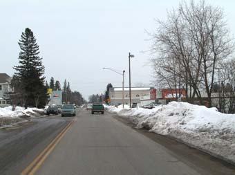
2 A. L. K. B. J. C. I. D. H. E. F. G
3 DESIGN STRATEGIES LESTER RIVER NEIGHBORHOOD: PLAN FOR LINKING GATEWAY RESOURCES The existing site resources embody the elements of the North Shore experience. A picturesque lake front, historic structures and landscapes, river gorge, geological out crops, mixedwood forests and community create the foundation for design. By using the movement of water as inspiration and the establishment of new North Shore Meadow plantings, the integration of Land, Water & People have be composed into the North Shore experience. This Gateway to the North Shore beautifully transitions from urban environment to the natural wilderness of the Superior Highlands. LONDON ROAD Problems of pedestrian access and traffic are addressed by reconfiguring the existing road, adding a planted median and turn lanes, new Lester River Bridge, placement of a traffic light at the 60th St. intersection, restricting parking during rush hours to permit four lanes of traffic, and new sidewalks. The changes occur within the current alignment so that no changes to property occur. The historic Lester River Bridge is preserved for bicycle and pedestrians. A crosswalk and an underpass provide access between Gateway Park and the trail along the Lester River. LESTER RIVER BUSINESS DISTRICT Widened sidewalks, new paving at intersections, street trees, and renovations of building facades create a welcoming experience to the neighborhood business district. New pedestrian connections to the Lester River and Lake Superior make movement between the local businesses and these amenities easier and more enjoyable. The widened sidewalk and new street trees along 60 th create a new connection for the Lake Walk to Run from the Railroad easement to the Lake with a new controlled intersection at 60th and London Road making access to the public park along Lake Superior easier and safer for neighborhood residents and visitors. LESTER PARK A new Lester Park addition follows the River Gorge on the East bank. The removal of S 61st Ave E. allows for new forest plantings, trail, and rain garden swales to create a new naturalized landscape that connects the existing Lester Park to Lake Superior and trail system. The park incorporates interpretive design at rain garden locations and historic quarried ponds. A new access Road maintains the E.P.A. access while providing new parking. The extension of Lester park to the lake connects Lester Park and Brighton Beach creating an ecologically sustainable landscape with new recreational opportunities. 18
 Controlled intersection with stop lights at 60th st.")
4 NSSD HWY.61 Boulevard Plantings improve connection to Superior St. Potential connection to lake walk Sidewalk widened to 6 ft. New entrance to gateway park Parking (30 cars) Controlled intersection with stop lights at 60th st. Views to historic lester river bridge and lake superior Rain Gardens Interpretive rain garden New lester river bridge Promontory Cairn sculpture experiential gateway Crosswalk marked w lighting Plantings frame views Upper trail Paths Park trail replaces road Spur trail Historic weir Foot bridge Lake superior vista Underpass trail Rain water garden with rock plinths used to mark water levels Fence line Lower trail along infiltration pond Parking (20 cars) North shore meadow Plantings buffer the lake shore Sinuous paths Canoe & sea kayak access at roadside parking Parking with potential expansion (20-50 cars) Retain existing gazebo New limnology building 19 19
5 DESIGN STRATEGIES LESTER RIVER NEIGHBORHOOD: PLAN FOR LINKING GATEWAY RESOURCES GATEWAY TRAILS Interpretive rain gardens layer cultural, historic, geologic and ecological resources in an ecologically sustainable design. The trail meanders through coastal meadows and a mixed wood forest to locations with splendid views of Lake Superior. The new alignment allows for the continuation of the Lake Walk through Brighton Beach. UNIVERSITY OF MINNESOTA LIMNOLOGY STATION The redesigned London Road increases the size of the campus, providing room for rainwater gardens and an additional building. The redesigned London Road / 60th Street intersection provides an attractive, safer entrance to the station s campus for arrival by foot, bicycle, or car. A 30 car parking lot is provided for visitors and staff. The rainwater gardens and a naturalized lakeshore provide interpretive/educational opportunities for a new Lake Superior Observatory and Interpretive Center. ENVIRONMENTAL PROTECTION AGENCY CAMPUS Access to the Environmental Agency is provided off Superior Street and London Road. Sustainable meadow, turf, and infiltration ponds characterize the campus. Footpaths wind around the historic quarried landscapes and wier structures as interpretive resources. 20

6 EXISTING EASTBOUND PASSAGE: CAIRN GATES & SIGNAGE 21 21
7 DESIGN STRATEGIES LESTER RIVER NEIGHBORHOOD: ILLUSTRATIVE VIEWS SUPERIOR STREET AND 60 TH STREET INTERSECTION Benches, crosswalks, streetlights, and renovated store facades define this neighborhood commercial area as a place that has a relationship to both the Lester River and Lake Superior. Boulevard trees connect Lester River Business District to Lake Superior ENTRANCE TO LIMNOLOGY CAMPUS AT LONDON ROAD AND 60TH New green space in front of the historic limnology building is created by a the alignment of London Road. Sightlines to Lake Superior, limnology building, and cairn gates mark the historic Highway 61 bridge create and experiential gateway. New Lighting, paving pattern and vegetation create an inviting entrance with the use of North Shore Meadow plantings to create separation of public and private space. LESTER RIVER BRIDGES The historic Lester River Bridge is converted to pedestrian use. A riverine path meanders over the bridge connecting the green spaces on each bank. The new Lester River Bridge reflects the character of the historic bridge and accommodates four lanes of traffic at times of peak traffic. The London Road underpass accommodates both pedestrians and storm water that has been retained and cleaned before flowing into the lake. 22


8 SUPERIOR STREET & 60TH STREET INTERSECTION Boulevard plantings create an extension of Gateway park to the community node at Superior St. and 60th. Other improvements include benches, crosswalks, street lights and revitalized building facades. LIMNOLOGY CAMPUS ENTRANCE AT LONDON RD & 60TH The new London Rd. alignment creates more green space in front of the Limnology station. The space is used to create an experiential park gateway that highlights the historic lester river bridge and original Hwy. 61 alignment. The paving pattern in the foreground, acts as an entrance to the naturalized shoreline and shows the entire north shore, a preview to the north shore scenic drive. LESTER RIVER BRIDGES The historic lester river bridge has been preserved and converted to a pedestrian bridge with new paving and turf along its course. The riverine path meanders over the bridge connecting both sides of the lester river as public green space. The new lester river bridge reflects the historic aesthetic of the original and accommodates 4 lanes of traffic that solve peak flow and safety issues. 23


9 DESIGN STRATEGIES BRIGHTON BEACH/GITCHI GAMI PARK: NSSD GATEWAY The design serves as both an experiential and literal gateway to the north shore. It uses the experience of passage over the Lester River and relationship with Lake Superior to enhance the experience of heading east on the NSSD. The concept uses the understanding of water; its natural, contrived and social aspects to tell the story of the landscape and lake. By creating a place that provides the experience and interpretation of the North Shore Waters those who experience the site leave with greater understanding, meaning, and sense of place. LAND, WATER & PEOPLE... concept expresses the interconnections between land and water by source, movement and destination. This connection is intrinsically tied to the social landscape through habit and use. It is through the understanding of this relational triad the story of Land, Water & People can be interpreted and understood as a North Shore Experience. OBLIQUE VIEWS OF BRIGHTON BEACH 24

10 CONCEPT DEVELOPMENT 25
11 DESIGN STRATEGIES BRIGHTON BEACH: GATEWAY PLAN VISITORS CENTER In this plan the visitors center provides information on shore wide resources as well as having a small store. Restroom facilities allow the center to function for park use as well as a gateway facility. Preliminary design work, shown in the appendices, describes a variety of architectural expressions. The location of the structure is precisely located to allow for maximum visibility from both road directions while maintaining a secluded lake side. CAIRN SIGN The cairn sign addresses the NSSD as a trail through the natural northwoods landscape. It constructed of boulder, stainless metal hardware and timber. The timber frame allows for highway signage to be attached to the rock cairn and becomes the highway design standard for NSSD resource locations. PARK ENTRANCE AND PARKING LOTS Realigning the Brighton Beach Park entrance and the park drive eliminates erosion problems and creates a naturalized lake front with new recreational trail. The parking lot is placed away from the shore and screened from the highway by trees. Stormwater runoff from the parking lot is filtered by rainwater gardens before it enters the lake. A small parking lot is provided off Highway 61 for the existing gazebo. TRAIL The park s trail sinuously moves through a signature north shore coastal landscape of meadow, forest, rocks, and water. The 12 multiuse trail runs through Brighton beach an connects to the adjacent rest stop interpretive trail. 26
 Visitor s center Spruce, birch, dogwood & wildflower plantings Rain garden 3 stem clump river")

12 NSSD GATEWAY SIGN AT BRIGHTON BEACH New intersection & NSSD timber signage Possible trail alignment Potential road alignments Rain swale Turf area Parking (55 stalls) Visitor s center Spruce, birch, dogwood & wildflower plantings Rain garden 3 stem clump river birch Existing trees Pine plantings NSSD cairn sign The 4 interpretations Visitor s center Rain swale North shore meadow Perspective view A NSSD kiosk The 4 interpretations North shore meadow restoration Floating turf deck Wood & steel deck: elevated 12 Rain garden 27 27
13 DESIGN STRATEGIES BRIGHTON BEACH: PHASING STRATEGY PHASE I Site grading for cairn. North Shore Scenic Drive cairn Land forms, vegetation, and signs mark this intersection as a gateway. Pine plantings PHASE II Parking lot Site grading Rain swale and rain garden North Shore Scenic Drive kiosk Deck Four interpretations Additional plantings Road removal New entrance and driveway PHASE III Visitors Center Deck extensions New entrance and driveway Turn around Trail construction New parking at existing gazebo Additional north shore plantings Lakeside turf areas Additional trees 28

14 PHASE I PHASE II PHASE III 29 29
15 BRIGHTON BEACH: CONCEPT DETAILS The Land, Water, & People concept is an expression of the North Shore experience, that being an experience of water. The North Shore Waters is truly understood as a relationship or more appropriately, as a series of relationships. These consist of interactions taking place in costal environments, native undisturbed landscapes, industrial mining or forested areas, in places of varying soils or glacial histories, and in areas of differing social history. Details are used in the design to visualize these varying interactions, provide interpretive or education opportunities, and creates a sustainable place. The experience of water movement, natural environments, and the hardscapes of built environments are interwoven as a series of complementary and contrasting spaces to convey the northshore story. Through the use of sinuous form and meandering circulation that contrasts with geometric social spaces, this relationship provides a unique and memorable Gateway indicative the place we are gaining passage. THE FOUR INTERPRETATIONS A raised turf deck floats above the naturalized landscape, allowing the rain swale to pass under the deck. The swale is revealed in a open central circle that allows visitors to interact with materials, vegetation and water. The seating wall that supports the deck has four inscribed granite plinths that tell the story of land, water, people, and orientated on a vista axis from the structure, Lake Superior. RAIN SWALE The collects, moves and infiltrates storm water flows. The boulder channel is planted with native wildflower and grass species. The system of channel boulders, rocks, and weirs collect, store and move water facilitating the absorption and filtration of water nutrients by plants, soil and rocks. Rain swales serve as interpretive opportunities visualizing the complex relationship of hydrological systems interacting with natural landscapes and built environments. FOOTBRIDGE The footbridge is used to provide pedestrian circulation at difficult grade changes and over water. Bridges are used at specific locations to enhance experience, provide vistas and interpretation. It is made of the North Shore Scenic Drive s signature vocabulary of steel and timber. 30

16 The 4 Interpretations A raised turf deck floats over the landscape allowing a continuous course for the rain swale. The deck support a seating wall with 4 interpretive granite plinths telling the story of land, hydrology, social history and Lake Superior. The Footbridge The footbridge is a crucial element in acknowledging the movement of water through experience. The steel and timber materials follow the NSSD design vocabulary Rain Swale This swale collects, moves and infiltrates storm water flows. The swale is constructed of a boulder channel with native wildflower and grass species planted in the channel course and banks Rain Swale Sections These sections describe how a system of channels, boulders, rock, and weirs collect and move water while allowing for infiltration and nutrient uptake by native plant species 31 31


17 DESIGN STRATEGIES SCENIC DRIVE INTERCHANGE: STRATEGIES FOR NSSD, HWY. 61 EXPRESSWAY, SUPE- RIOR ST., RAILROAD, AND RECREATION. The existing area of the NSSD interchange consists od automobile, train, and pedestrian circulation. Steep slopes, grade separated lanes and a series of turn off lanes has created a dangerous intersection with few visual que s marking the change from expressway to residential neighborhood. The following represents a concept for dealing with grade issues, traffic speed mitigation, NSSD signage, locomotive and pedestrian circulation. THE CONCEPTS Superior St., the North Shore expressway, the scenic railroad, and the beginning of the North Shore Scenic bypass all meet in a new controlled intersection. Traffic is encouraged to the Lester River Business District via. Southbound exit lane. Land forms, vegetation, cairns, and signs mark this intersection as a gateway. Traffic signals, crosswalks, drop arms, and signs mark change and mitigate traffic speeds. Traffic signs and the lack of a highway divide will slow expressway traffic coming down the hill towards Duluth. New crosswalks provide potential pedestrian connections to the Lakewalk. A southbound turning lane to Superior Street bypasses the intersection; rock is exposed along this new turning lane. The new expressway alignment brings traffic together at the crest of the hill in order to create an experiential que of leaving the high speed expressway. Travel is encouraged on the NSSD by rock cairn sign. A potential northbound exit lane to the NSSD would further encourage traffic but, would create more pedestrian crossing for a trail that connects lake walk and Brighton Beach. A new road replaces the existing Brighton Beach road. The alignment maintains the lake edge driving experience by meandering inland and back to the shore creating a series of new enlarged park spaces and a ecologically sustainable shoreline. OBLIQUE VIEWS OF INTERCHANGE & BRIGHTON BEACH 32


18 SECTION AT NSSD & EXPRESSWAY INTERSECTION (NORTHBOUND) Exposed rock face creates a stage for the NSSD cairn sign and creates a gateway Expressway to two harbors MEDIAN OPTIONS 50ft. median merges to 4 lanes non-divided 4 lanes of traffic with turning lane NSSD logo on exposed rock face Gateway hill Superior St. Exposed bedrock face & cairn sign Gateway hill Gateway hill Train Line Exposed bedrock face & cairn sign Gateway hill NSSD 61 scenic drive New access trail to lake front New parking (20 cars) Open meadow Existing shelter Top of hill Vista to Duluth 50ft. median merges to a 10ft. median Top of hill Roadside trail Vista to Duluth HWY. 61 Vistas to lake superior & shoreline Raod & trail meander through forest to open up views of lake superior Shoreline reforestation Views of lake superior SOUTH BOUND ILLUSTRATIVE 33 33


19 DESIGN STRATEGIES BYWAY REST STOP / INTERPRETIVE TRAIL PLACEMAKING ALONG THE NSSD This is a prototypical environmentally sensitive design for rest stops along the North Shore Scenic Byway. It provides conceptual strategies on using the existing environment to create places along the NSSD where users are encouraged to leave their automobiles and experience the North Shore Landscape. THE CONCEPTS Signature North Shore Scenic Drive design elements are used: signage, kiosk, bridge and native vegetation. The site is conceived as a rest area with interpretive trail. A variety of unique environments create multiple trail resting locations with interpretation. A facility provides restroom, information, water, and bike parking. Unique microclimates and planted with native North Shore meadow environments. Access to the lake in provided by walking trail in various locations. The parking lot is placed away from the shoreline to minimize runoff pollution with large naturalized landscapes encouraging infiltration.. Rock is exposed where appropriate. Interpretation of geology, soils, woodlands, erosion, stream gorge and Lake Superior are interwoven into a story of this place along the North Shore Scenic Drive. OBLIQUE VIEWS OF REST STOP 34
 Parking expansion & egress Drainage gorge interpretation Trailhead")

20 NSSD KIOSK Metal roof 2x8 rough cut 4x4 posts Lake superior interpretive stop North shore meadow microclimate Stainless square bar TIMBER SIGNAGE Interpretive panel Bench seat Concrete base Stainless metal bar BRIDGE WITH INTERPRETIVE PANEL Proposed pine reforestation Geology, soils, & erosion interpretive stop Parking (25 stalls) Parking expansion & egress Drainage gorge interpretation Trailhead facility Service drive: class 5 Restroom facility Steel rail, bar, & I-beam Eroded shoreline Beach environment interpretive stop Rock & pebble beach Trail connects to future brighton beach trail Exposed bed rock shoreline Woodland environment interpretive stop Unmarked beach trail Existing forest NSSD kiosk Pine plantings Bike racks Vistas to lake over meadow environment TRAILHEAD FACILITY 35 35
21 DESIGN STRATEGIES GATEWAY FRAMEWORK: FOUR STRATEGIES The following plan shows an integrated view of the four strategy areas developed in this project. The major moves consisted of: Improved integration of the Lester River Neighborhood to Lake Superior and Brighton Beach A Plan that promotes the Superior St. Business District. Provides new connections and extension of the Lake Walk. Uses the Historic Limnology Lab as an interpretive resource and new major center for education, information and other services relating to the Lake Superior region. Proposes new London Rd. design to handle peak traffic flows by closing parking during peak hours. The proposal creates a controlled intersection at 60th and London Rd. to improve pedestrian circulation to the lake. The historic Lester River Bridge is preserved as a pedestrian crossing. Road alignment changes create larger lake front space. Lester Park is extended to the lake connect the Lester Park, Lake Superior, and Brighton Beach. Native plantings and larger shorelines creates an ecologically sustainable lakefront. Parking is provided to maintain beach and river access for fishing, surfing and other recreation. Dangerous pullouts are removed and a new enlarged safe pullout is created at the existing gazebo. Brighton Beach/Gitchi Gami Park provide a land base for the new NSSD Gateway facility. Brighton Beach Rd. is realigned to provide more space along the shoreline for sustainable plantings and recreational use. Trails connect rest stop and lakefront environments. A new NSSD interchange resolves existing dangerous intersections and provides for signage and pedestrian use. The design works as a connected whole to create a Gateway to the North Shore experience. 36

22 BYWAY REST STOP LESTER RIVER NEIGHBOR- HOOD SCENIC DRIVE INTERCHANGE BRIGHTON BEACH 37 37
ALTERNATIVE STATION AREA -
 ALTERNATIVE STATION AREA - THE 10 TH STREET GARDEN STATION Two alternative land use scenarios and designs are illustrated here: Scheme A - Transit-Oriented Development High to Mid-Density Residential /Office
RLRC COMMUNITIES THIEF RIVER FALLS AREA CHARACTER COMMUNITY TRAIL OPTIONS OAKLAND PARK EXISTING CONDITIONS OAKLAND PARK DESIGN DESIGN DETAILS
 THIEF RIVER FALLS AREA CHARACTER COMMUNITY TRAIL OPTIONS OAKLAND PARK EXISTING CONDITIONS OAKLAND PARK DESIGN DESIGN DETAILS 61 THIEF RIVER FALLS AREA CHARACTER Thief River Falls has a number of existing
Seneca Meadows. Block 4 Locate office, technology, and medical development adjacent to I Screen views of garage structures from I-270.
 Seneca Meadows Seneca Meadows has an industrial park in its southern end and a mixed-use employment area planned for the north end. The district benefits from extensive I-270 visibility, stream valley
VEHICULAR AND PEDESTRIAN CIRCULATION
 This perspective sketch communicates the intended character and quality of a proposed streetscape design. Locate benches near a major intersection where people tend to gather. Seating and lighting provide
GATEWAY DESIGNS FOR THE NORTH SHORE SCENIC DRIVE
 GATEWAY DESIGNS FOR THE NORTH SHORE SCENIC DRIVE Lester River, Duluth Minnesota THE CENTER FOR CHANGING LANDSCAPES UNIVERSITY OF MINNESOTA ACKNOWLEDGEMENTS This project was produced and completed by The
Potential Green Infrastructure Strategies May 6, 2015 Workshop
 Potential Green Infrastructure Strategies May 6, 2015 Workshop Background The City of Cortland is developing the Tioughnioga Urban Headwaters Green Infrastructure Action Plan with funding from the National
The open space system should provide connective elements, relate to natural resources, and enhance the suburban character of the landscape..
 The open space system should provide connective elements, relate to natural resources, and enhance the suburban character of the landscape.. Mixed-use and infill development should maintain or enhance
Glenn Highway MP DSR. Landscape Narrative
 Glenn Highway MP 34-42 DSR Landscape Narrative Project Landscape Goals The Glenn Highway MP 34-42 Project extends through a variety of landscape types typical to the Matanuska-Susitna Valley. In general,
Reconnecting to a Forgotten River St. Cloud MN. Aaron Hanson Design Design Thesis LA 572, Thesis, Spring 2012
 Reconnecting to a Forgotten River St. Cloud MN Aaron Hanson Design Design Thesis LA 572, Thesis, Spring 2012 site context 2.5 Miles Sartell St. Cloud to Fargo 170 Miles (2 hrs 45 mins) Hwy 10 infrastructure
Route 347. New York State Department of Transportation Region 10, Long Island. THE GREENING of ROUTE 347
 The GREENING of Route 347 The Greening of Route 347 The Greening of Route 347: History 3 The Greening of Route 347 4 The Greening of Route 347 5 The Greening of Route 347 Smith Haven Mall 6 The Greening
PHASE 3-4 PARKS SOUTH PARK AND CHANNEL PARK
 PHASE 3-4 PARKS SOUTH PARK AND CHANNEL PARK Sheet List L1.0 L2.0 L3.0 L4.0 L5.0 L6.0 L7.0 L8.0 L9.0 L10.0 L11.0 L12.0 L13.0 L14.0 L15.0 L16.0 L17.0 L18.0 L19.0 L20.0 L21.0 L22.0 Cover Open Space Context
Figure 3-1: Public Realm Plan
 3 Public Realm Figure 3-1: Public Realm Plan 3.1 Public Realm Concept The public realm concept for the Little Mountain site integrates a clear and accessible movement network with public spaces for social
BEMIDJI CITY COUNCIL Work Session Agenda Monday July 9, 2012
 BEMIDJI CITY COUNCIL Work Session Agenda Monday July 9, 2012 City Hall Conference Room 5:30 p.m. 1. CALL TO ORDER / ROLL CALL 2. REVIEW PARK PLANS FOR PAUL BUNYAN PARK, LIBRARY PARK AND SOUTH SHORE BAUER
OPPORTUNITIES AND CONSTRAINTS - OXBOW PARK ENTRANCE AND PUT-IN
 OPPORTUNITIES AT OXBOW EXISTING WETLANDS Site is undeveloped and we can design a park that works well from the start. SAND BEACH Potential to eliminate invasive species. DEBRIS (CONCRETE, OLD CARS) VEGETATION
V. Gateways GATEWAYS / V-1
 V. GATEWAYS / V-1 Many of Chesapeake s gateways are located on highways and call for bold and attractive designs that motorists can understand, appreciate, and enjoy. can also take the form of natural
Toronto Complete Streets Guidelines
 Toronto Complete Streets Guidelines 108 110 7.1 Green Infrastructure Design Principles 112 7.2 Context-Sensitive Green Streets 114 7.3 Key Green Street Elements Green infrastructure refers to natural and
COMMUNITY DESIGN. GOAL: Create livable and attractive communities. Intent
 COMMUNITY DESIGN Intent An attractive, well-designed County will attract quality development, instill civic pride, improve the visual character of the community, and create a strong, positive image for
Town Center. Block 5 Existing multifamily residential units are expected to remain.
 Area Guidelines Germantown s districts should be developed as distinct communities with unique features that are supported through the guidelines. The guidelines not only help distinguish these districts
Daniels Park Master Plan
 Daniels Park Master Plan Prepared for: Douglas County & The City and County of Denver October, 2007 EXHIBIT A Contents Daniels Park Overview 2 Project History & Goals 2-3 Regional Context Map 4 Park Zone
Table of Contents. Elm Avenue Improvement Plan City of Waco, Texas. Introduction 1. Existing Context 1 Figure 1 2.
 Table of Contents Introduction 1 Existing Context 1 Figure 1 2 Plan Guidelines 3 Future Urban Form 4 The West-End 4 Main Street 6 The East-End 7 Figure 2 9 Public Improvement Recommendations 7 General
Section4 Design Vision & Implementation Plan
 Section4 Design Vision & Implementation Plan W Woodschurch Rd 4.1 Design Focus Areas The Framework Plan is simply the starting point for directing the design and implementation of a wide range of transportation
Stakeholders Advisory Working Groups (SAWGs) Smart Growth and TOD Land Use (#11) SAWG Meeting
 Smart Growth and TOD Land Use (#11) SAWG Meeting") Presentation - Part II Tappan Zee Bridge/I-287 Corridor Project July 21, 2010 Slide 1. David Kooris (Regional Plan Association) welcomed members of the Land Use Stakeholders Advisory Working Groups (SAWGs)
Presentation - Part II Tappan Zee Bridge/I-287 Corridor Project July 21, 2010 Slide 1. David Kooris (Regional Plan Association) welcomed members of the Land Use Stakeholders Advisory Working Groups (SAWGs)
COMPLETE GREEN STREET CHECKLIST
 COMPLETE GREEN STREET CHECKLIST This document was developed to dissect the structure of an urban street and explore opportunities to make our streets more complete while also integrating green street strategies.
MOUNT ROSE AND WASHOE VALLEY SCENIC BYWAY CORRIDOR MANAGEMENT PLANS
 MOUNT ROSE AND WASHOE VALLEY SCENIC BYWAY CORRIDOR MANAGEMENT PLANS PARK COMMISSION JANUARY 5, 2016 PREPARED BY Aspen Asheville Austin Chicago Denver Dubai Houston Lake Tahoe Los Angeles CORRIDOR MANAGEMENT
Chapter 5: Mixed Use Neighborhood Character District
 5: Mixed Use Neighborhood Character District 5.1 Introduction The Mixed Use Neighborhood character district acts as a transition or bridge between the State Route 89A District s commercial area to the
ARTICLE IV: DEVELOPMENT STANDARDS 404 MASTER PLANNING
 IV 13 404 MASTER PLANNING Master Planning through the Site Analysis (Master Planning Site Analysis) or Planned Development (Master Planning Planned Development) is provided to encourage development which
AGENDA ACTION ITEMS INFORMATION ITEMS
 NOACA Bicycle and Pedestrian Advisory Council Meeting Friday, March 21 st, 2014 10:30 a.m. NOACA Office 1299 Superior Avenue Cleveland, Ohio 44114 Phone: (216) 241-2414; website: www.noaca.org AGENDA ACTION
Kittson Parkway / Watershed Park Parking Lot
 Kittson Parkway / Watershed Park Parking Lot Date Constructed: Summer 2005 Site Location / Description: Kittson Parkway, North Delta, British Columbia. Permeable parking lot adjacent to Watershed Park;
Commercial Node Plan Devine Street/Jackson Blvd. COLUMBIA, SC
 Commercial Node Plan Devine Street/Jackson Blvd. COLUMBIA, SC 9.17.13 AGENDA 1 Introductions 2 Project Update 3 Concepts 4 Recommendations 5 Next Steps Introductions Project Update Process 5-Phase Process
ADOPTED CAPITAL IMPROVEMENT PROGRAM BUDGET ARROYO PROJECTS
 ADOPTED CAPITAL IMPROVEMENT PROGRAM BUDGET ARROYO PROJECTS HAHAMONGNA FY 212-216 Capital Improvement Program Priority Description Total Estimated Costs Appropriated Through FY 211 Adopted FY 212 FY 213
Neighborhood Districts
 NEIGHBORHOOD DISTRICTS SEVEN MAIN DISTRICTS Neighborhood Districts While the Development Plan provides a broad-scale overview of the neighborhood, this section focuses on uses and relationships at the
7.0 SOCIAL, ECONOMIC, AND ENVIRONMENTAL ISSUES
 7.0 SOCIAL, ECONOMIC, AND ENVIRONMENTAL ISSUES The following list of social, economic, and environmental issues have been identified based on a preliminary inventory of resources in the project area, an
Mendota Heights 2040 Comprehensive Plan Draft Vers
 4 Parks and Trails The City of Mendota Heights boasts a variety of recreational and open space opportunities. Few cities can claim access to regional trails, riverside and lakeside parks, scenic bluffs
URBAN DESIGN BRIEF 305, 309, & 315 SOUTHDALE ROAD WEST LONDON ONTARIO
 URBAN DESIGN BRIEF 305, 309, & 315 SOUTHDALE ROAD WEST LONDON ONTARIO CARVEST PROPERTIES LTD. December 2013 Section 1 - Land Use Planning Context 1.1 Subject Lands The subject lands are located immediately
Public input has been an important part of the plan development process.
 Lakewood s Comprehensive Plan recognizes that transportation helps shape the community, and that the way the community provides for the safe and efficient movement of people affects the character of the
Community Design Guidelines. Port Wallace DRAFT
 Community Design Guidelines Port Wallace DRAFT Energy 1 2 3 Nature Movement Connections Built Form DRAFT Layout Energy 1 Nature Community Design Guidelines GREAT COMMUNITIES PROTECT, CELEBRATE, AND CONSERVE
LANDSCAPING. Design. Development of the site shall not unreasonably impair the ability of adjoining properties to utilize solar energy.
 Landscape design is an integral component of Site Planning and Building. The current pattern of walkways, driveways and landscape elements such as fences, hedges, and retaining walls in the neighborhood
The following principles guide the development of goals and strategies to protect and promote these amenities:
 OPEN SPACE/PARKS/TRAILS/RECREATION GOALS/STRATEGIES Cherry Hills Village is a living environment that offers low density development, open areas, public scenic vistas, public trails and public parks. This
Hidden Pointe Landscape Master Plan. June, archi terra
 Hidden Pointe Landscape Master Plan June, 2006 t h e archi terra g r o u p 1 Table of Contents Background Purpose and Goals of the Master Plan Master Plan Process Existing Conditions Entrance Hidden Pointe
4.1 AESTHETICS AND VISUAL QUALITY
 SCOPE AND METHODOLOGY 4.1 AESTHETICS AND VISUAL QUALITY This section evaluates the potential impacts to aesthetics and visual quality. Aesthetics refers to visual resources and the quality of what can
Fifth and Detroit Street Design May 2017 Capital Improvements Committee. DOWNTOWN Street Design
 1 Fifth and Detroit Street Design May 2017 Capital Improvements Committee Agenda 2 Review Street Configuration Prior Meeting Review Outreach Synopsis Functional Street Design Refinements Curb Edge, Turning
ACADEMY AREA CONCEPT PLAN
 ACADEMY AREA Strip ling C hape l Roa d CONCEPT PLAN 7 S2 U Stripling 52 ROADWAYS AND PARKING: ADVENTURE PLAYGROUND AND SPRAYGROUND: Current roadways follow existing drives. It is recommended that the Folds
Throughout. square. (Crystal City Vision Plan 2050)
") 1: Terms related to the PSMP document 1 public space (see also public realm, civic space) An open space designated on the regulating plan, accessible to all, including Plazas, Mini Parks, and Neighborhoods
1: Terms related to the PSMP document 1 public space (see also public realm, civic space) An open space designated on the regulating plan, accessible to all, including Plazas, Mini Parks, and Neighborhoods
ARROYO PROJECTS ADOPTED CAPITAL IMPROVEMENT PROGRAM BUDGET
 A RROYO P ROJECTS ADOPTED CAPITAL IMPROVEMENT PROGRAM BUDGET FISCAL YEARS 214-218 HAHAMONGNA Priority Description 1 Hahamongna Watershed Park - Implement Master Plan 211,6 211,6 (77565) 2 Hahamongna -
Classroom Science Building
 Classroom Science Building Public Realm Presented by: Gary Branville, Joe Moore, Justin Rechtzigel, Tom Roth & Hailey Wall Proposal Objective: To create a node on the Grand Rounds Parkway Connect the public
Site Design (Table 2) Fact Sheet & Focus Questions:
 Fact Sheet & Focus Questions:") Site Design (Table 2) Fact Sheet & Focus Questions: BACKGROUND WHAT IS SITE DESIGN? Site design refers to the arrangement of buildings and open spaces on adjacent sites to maximize the shared benefits
Site Design (Table 2) Fact Sheet & Focus Questions: BACKGROUND WHAT IS SITE DESIGN? Site design refers to the arrangement of buildings and open spaces on adjacent sites to maximize the shared benefits
SQUAMISH 2010 AND BEYOND COMMUNITY VISION
 Our plan has been imagined and created to be both pragmatic and visionary. At the core of the strategy is a consideration of the highway s role and its impact on the community. First and foremost in creating
ATTACHMENT A. SILVERDALE DESIGN STANDARDS Amendments to the Waaga Way Town Center Chapter
 ATTACHMENT A SILVERDALE DESIGN STANDARDS Amendments to the Waaga Way Town Center Chapter Chapter 10. Waaga Way Town Center 10.1 Physical Identity Elements & Opportunities The Waaga Way Town Center includes
DRAFT ROOSEVELT ROAD. District Recommendations. Figure 5.23 The Roosevelt Road Corridor
 CHAPTER 5 Figure 5.23 The Road Corridor Road will develop as a mixed-use corridor, emphasizing regional retail, west of the river and mixed-use development east of the river. KEY RECOMMENDATIONS 1. High
Dogpatch/22nd Street Greening
 TEAM MEMBERS Prepared for: GreenTrustSF Central Waterfront www.gtsfcw.org Prepared by: Fletcher Studio San Francisco, CA www.fletcherstudio.com Landscape Architecture Urban Design Environmental Planning
Transportation. Strategies for Action
 Transportation A major priority for the Overlake Neighborhood is to develop a multimodal transportation system. To achieve this system, a balance has to be found among travel, circulation and access needs;
APPENDIX D: Visual and Aesthetic Conditions for NCCU Station Refinement. Durham-Orange Light Rail Transit Project
 APPENDIX D: Visual and Aesthetic Conditions for NCCU Station Refinement Durham-Orange Light Rail Transit Project October 2016 1. Introduction The Combined FEIS/ROD summarizes the effects of the D-O LRT
Applicant Name Phone / Fax / Address City State Zip Code . Property Owner Phone / Fax / Address City State Zip Code
 Master Development Plan Application Community Development Department City of Redmond 411 SW 9 th Street Redmond, Oregon 97756 541-923-7721 541-548-0706 FAX Master Development Plan Fee $38,862.52 File Number
Better Cycling. The City will update the cycling master plan (London ON Bikes) based on the approved BRT network.
 based on the approved BRT network.") Better Cycling Dedicated bike facilities will be constructed along BRT corridors where space is available. Nearby bike routes will also be upgraded to ensure a complete network is available for cyclists.
Better Cycling Dedicated bike facilities will be constructed along BRT corridors where space is available. Nearby bike routes will also be upgraded to ensure a complete network is available for cyclists.
Port of Camas-Washougal Waterfront Trail Master Plan
 Port of Camas-Washougal Waterfront Trail Master Plan The Port s facilities are the products of its mission: To make strategic investments that enhance the community s quality of life by bringing jobs,
Storm Water Quality and Shoreline Restoration Improvements - Grant Funding Request City of Mound Carlson Park Bolton & Menk Project No.
 September 15, 2016 Brett Eidem Cost Share Grant Administrator Minnehaha Creek Watershed District 15320 Minnetonka Boulevard Minnetonka, MN 55345 RE: Storm Water Quality and Shoreline Restoration Improvements
SFMTA PHELAN LOOP AND PUBLIC PLAZA PHELAN OCEAN AVENUE
 SFMTA Municipal Transportation Agency Image: a bus in front of the Palace of the Legion of honor SFMTA PHELAN LOOP AND PUBLIC PLAZA PHELAN AVENUE @ OCEAN AVENUE Community Meeting May 23, 2012 San Francisco,
319 Grant: Baker Creek & Centenary Creek Restoration Initiative
 319 Grant: Baker Creek & Centenary Creek Restoration Initiative Objectives: Overview of Watershed Characteristics: Discussion of Project Tasks: Discussion of Watershed Management Plan: Presented by: Erich
include playgrounds, sports fields, community gardens and picnic areas.
 DEVELOPMENT PLAN OPEN SPACE SYSTEM OPEN SPACE SYSTEM The neighborhood provides for a range of open space types. The Village Square is an important open space in the neighborhood. It serves as a gathering
SOUTH UNIVERSITY Street Design Setting a Direction for Schematic Design
 1 SOUTH UNIVERSITY Street Design Setting a Direction for Schematic Design Meeting Agenda 2 1. Project Scope 2. Design Direction 3. Design Details 4. Schedule and Construction Logistics 3 SOUTH UNIVERSITY
Mississippi Drive Corridor Revitalization. A DestinationTransportation Project...
 Mississippi Drive Corridor Revitalization A DestinationTransportation Project... Mississippi Drive Corridor Revitalization Welcome! Tonight s Agenda: Further define the Scope of the Project Discuss the
Chapter 4: Jordan Road Character District
 4: Jordan Road Character District 4.1 Introduction The Jordan Road character district encompasses much of the former Jordan orchard and farmstead, which was a significant part of Sedona s history. The
6-GATEWAYS, WAYFINDING & PUBLIC SIGNS
 6-GATEWAYS, Wayfinding & ublic Signs 6-GATEWAYS, WAYFINDING & UBLIC SIGNS Downtown Georgetown has a strong base of local users as well as seasonal tourists and visitors. Many first-time visitors, and those
ROME WATERFRONT VILLAGE PROJECT NARRATIVE January 25, 2018
 January 25, 2018 The Rome Waterfront Village project is intended to foster the revitalization of the area between South James Street and Erie Boulevard north of the Erie Canal as well as improve public
PRELIMINARY DESIGN + DEVELOPMENT PLAN
 WELCOME! To The Public Open House May 30 th, 2017 HARBOUR WEST PARKS Vision Project Overview The City s vision for Port Credit Harbour West Parks is to develop a vibrant waterfront destination that integrates
4 CIRCULATION AND TRANSPORTATION
 4 CIRCULATION AND TRANSPORTATION 4.1 INTRODUCTION One of the central concepts of the Hecker Pass Specific Plan is to maintain the rural character and scenic qualities of the area. The transportation and
3. STRATEGY FOR NEIGHBORHOOD SUSTAINABILITY
 3. STRATEGY FOR NEIGHBORHOOD SUSTAINABILITY This neighborhood plan focuses on assuring that Government Hill retains a high degree of sustainability, in that it conserves built resources that are part of
A. Background Summary of Existing Challenges and Potential Possibilities. 1. Summary of Existing Assets and Potential Opportunities
 A. Background 1 A Main Street Master Plan Study was performed and completed in October of 2007. The study was initiated to review current land uses and development patterns along Main Street, from Parrish
II. SINGLE FAMILY RESIDENTIAL
 II. SINGLE FAMILY RESIDENTIAL Castle Rock is made up of numerous individually built houses and subdivision tracts that have been developed during the past century. Some of the tracts are diverse in architectural
5. Father Hennepin Blufs Park and Hennepin Island Father Hennepin Bluffs Park Supporting Initiatives (see Figure 36): 7-22
: 7-22") 5. Father Hennepin Blufs Park and Hennepin Island As described in existing conditions portion of Chapter 2, Father Hennepin Blufs Park lies on the upland portion of the park and Hennepin Island spans the
5. Father Hennepin Blufs Park and Hennepin Island As described in existing conditions portion of Chapter 2, Father Hennepin Blufs Park lies on the upland portion of the park and Hennepin Island spans the
The Vision. Photo provided by The Minervini Group. 46 Vision, Objectives & Strategies
 Vision, Objectives & Strategies The is the public framework and guide for future development of the Grand Traverse Commons. The establishes public polices for infrastructure, the preservation of natural
Girdwood Cemetery Girdwood, Alaska
 Miners Pond Shelter Council Circle Woodl Trails Overlooks Committal Shelter Courts Woodl Burial Bridge to Beaver Pond Trail Protected Stream Valleys Columbarium Court Shelter Woodl Trails Woodl Cremation
Clair-Maltby Community visioning
 Clair-Maltby Community visioning workshop #1 Summary April 27th, 2017 Table of Contents INTRODUCTIon 1 PURPOSE 1 CONSULTATION STRUCTURE 2 PARTICIPANT FEEDBACK 3 VISIONING EXERCISE 8 ONLINE SURVEY RESULTS
Project Status. Construction is underway for Phase 3. Overall Project Area and Schedule. Schedule of Current Construction Phases.
 I-95 Avenue Interchange Project Status Construction is underway for Phase 3. Overall Project Area and Schedule Phase 0: Completed 2010 Section GR0: Completed in Fallin 2010 Phase 2: Completed Section GR2:
Century Park to Ellerslie Road Preliminary Engineering
 Century Park to Ellerslie Road Preliminary Engineering South LRT Extension Stakeholder Information Panel Brochure March 2010 www.edmonton.ca/lrtprojects LRT Station (left) and Transit Centre Architectural
3.1 community vision. 3.3 required plan elements
 Chapter 3 Community Form 3.1 community vision 3.2 Parks & landscaping concepts 3.3 required plan elements D R A F T 20 Community Form Chapter 3 3.0 Community form 3.1 community vision The Specific Plan
BUSINESS DISTRICT DESIGN GUIDELINES
 Des Plaines, Illinois Prepared for the City of Des Plaines by: The Lakota Group Laurie Marston, AICP March 2005 Section 5: Streetscape Elements Business District Design Guidelines STREETSCAPE ELEMENTS
Landscape and Streetscape Design 2.5
 Landscape and Streetscape Design 2.5 2.5.1 Goals 2.5.2 Planting 2.5.3 Sidewalks and Pavement 2.5.4 Furnishings 2.5.5 Walls 2.5.6 Lighting 2.5.7 Stormwater 2.5.8 Street Cross Sections 2.5 LANDSCAPE AND
Principles for Ecological Landscape Design in Brownfield Business Parks
 Principles for Ecological Landscape Design in Brownfield Business Parks Part of USDA Forest Service research project # 00-JV-11231300-033: Aligning Social and Ecological Drivers of Urban Landscape Change
Willamette Falls Downtown District Policies and Design Guidelines
 Willamette Falls Downtown District Policies and Design Guidelines The District Policies and Design Guidelines are mandatory for future development within the Willamette Falls Downtown District, and will
INTRODUCING THE BALTIMORE CITY GREEN NETWORK VISION PLAN
 INTRODUCING THE BALTIMORE CITY GREEN NETWORK VISION PLAN GOALS OF THE GREEN NETWORK PLAN Protect and enhance the unique ecological resources of our city Support economic growth and sustainable redevelopment
Establish a network of streetscaped vehicle and pedestrian routes that connect within and outside the Plan area.
 This Plan s urban design goals are to create an urban scale, walkable community with connections to transit, parks, and services and with amenities and facilities for residents and employees. The 1992
Open House RIVER DES PERES GREENWAY: LANSDOWNE SHREWSBURY METROLINK TO FRANCIS R. SLAY PARK
 Open House 10.12.16 RIVER DES PERES GREENWAY: LANSDOWNE SHREWSBURY METROLINK TO FRANCIS R. SLAY PARK MEETING AGENDA Great Rivers Greenway and Project Partners River des Peres Greenway Overview Project
Public Meeting #3 May 9, 2009 MVVA Team
 Public Meeting #3 May 9, 2009 MVVA Team Welcome to the third Public Meeting for the Lower Don Lands Municipal Class Environmental Assessment (EA) Infrastructure Master Plan and Keating Channel Precinct
Purpose of Open House #3
 Public Meeting #3 May 9, 2009 MVVA Team Purpose of Open House #3 The main purpose of this Open House is to present and seek input on the: Evaluation of transportation and infrastructure design alternatives
Access Management: An Overview
 Figures 1-5 Below Evolution of development along a highway. In the early stages, land along the road is used for farming with little traffic generated. As time passes, the highway corridor becomes a de
APPENDIX A. Consistency of the Mountain Park Specific Plan with the Goals and Policies of the Anaheim General Plan
 APPENDIX A Consistency of the with the Goals and Policies of the Anaheim General Plan I. Consistency of the Proposed Project with Land Use-Related Goals and Policies II. III. IV. Consistency of the Proposed
RECONNECTING A COMMUNITY TO THE CREEK
 RECONNECTING A COMMUNITY TO THE CREEK 0 The J.J. Seabrook Stream Restoration, Rain Garden, and Urban Trail Project Kristin K. Pipkin, P.E. Michelle Adlong, EI.T. TXSER/TRA Joint Conference November 2,
FLORIN ROAD CORRIDOR Site Plan and Design Review Guidelines Checklist
 FLORIN ROAD CORRIDOR Site Plan and Design Review Guidelines Checklist Applicant s Name: Project Address: Phone: Email: Applicant shall fill out the design guidelines checklist for all guidelines applicable
PRELIMINARY PLAT DESIGN REQUIREMENTS Updated 4/8/2016
 PRELIMINARY PLAT DESIGN REQUIREMENTS Updated 4/8/2016 The following items are required for the preliminary plat. Numbers correspond with those on the example preliminary plat. RENO COUNTY SUBDIVISION REQUIREMENTS
section five BEAUTIFICATION PLAN
 section five BEAUTIFICATION PLAN BEAUTIFICATION PLAN Section Five Beautification Plan The goal of the Beautification Plan is to improve the Route 8-Sunnyland Corridor in terms of aesthetics and to create
A Vibrant Downtown. Chapter 5 Cary Public Art Opportunities 31
 A Vibrant Downtown Cary s vision for Downtown is a unique, vibrant, dynamic, pedestrian friendly location; a regional destination and a place to live, work, and recreate, according to the 2001 Town Center
Community Design Plan
 Gardena General Plan 2006 Authority While the is not a required element of a General Plan, it is included because improving the community appearance and image is paramount to the overall quality of life
LOUISIANA STATE UNIVERSITY COMPREHENSIVE & STRATEGIC CAMPUS MASTER PLAN. APPENDIX G - Stormwater Study Findings & Stormwater Solutions
 LOUISIANA STATE UNIVERSITY COMPREHENSIVE & STRATEGIC CAMPUS MASTER PLAN APPENDIX G - Stormwater Study Findings & Stormwater Solutions LSU: MP Narrative July 2017 3.5 Open Space Existing Conditions The
3.0 master plan concept
 3.0 master plan concept 3.1 introduction The purpose of the Huron Church Road Master Plan Concept is to provide an overview of the Master Plan design process, identify preliminary streetscape installations
Reinventing Miner Avenue as a
 Reinventing Miner Avenue as a Complete Street Reinventing Miner Avenue as a Complete Street Agenda Project Overview / Introductions Previous Meeting Recap Economic Considerations Opportunities & Constraints
Lansing s Moores River Drive Regional Network Trail project extended the Lansing River Trail system to Waverly Road, and also included bike lane
 Lansing s Moores River Drive Regional Network Trail project extended the Lansing River Trail system to Waverly Road, and also included bike lane striping on W. Mount Hope Avenue. The boulevard on Moores
GUIDELINES EXHIBITION PLACE LOCATION: OBJECTIVES. Structure Plan URBAN DESIGN GUIDELINES
 Development in the Exhibition Place lands will be consistent with the following urban design guidelines. They provide a framework for new development of the lands and are to be read in conjunction with
BURTON STATION STRATEGIC GROWTH AREA PLAN UPDATE PUBLIC MEETING 3/26/18
 BURTON STATION STRATEGIC GROWTH AREA PLAN UPDATE PUBLIC MEETING 3/26/18 1 WHERE WE ARE? 2 PRIMARY OBJECTIVES OF THE PLAN UPDATE 1. Update the land use designation for Burton Station Village to reflect
More than 30 adults and 19 children were involved in these community workshops.
 Linwood Workshops held at Household of Faith Deliverance Church 3.29.08 and 4.05.08 What is a Design Workshop? We use the term workshop (often called charrette among design professionals) to describe a