City and County of Honolulu. Kalihi. Neighborhood Transit-Oriented Development Plan. Executive Summary
|
|
|
- Amelia Pearson
- 5 years ago
- Views:
Transcription


1 City and County of Honolulu Kalihi Neighborhood Transit-Oriented Development Plan Executive Summary June 2014
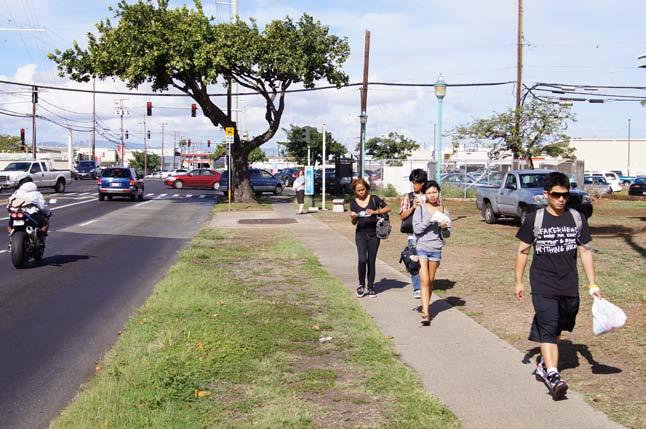
2 Planning for Rail Transit What is Honolulu Rail Transit? The Honolulu High-Capacity Transit Corridor Project is currently being undertaken by the U.S. Department of Transportation Federal Transit Administration and the City and County of Honolulu. The rail system is projected for completion in 2019 and will extend approximately 20 miles across Oahu. It will run on a fixed guideway system in an exclusive elevated right-of-way, serving 21 stations between East Kapolei and the Ala Moana Center. The rail project is expected to help reduce the growth of traffic congestion by taking cars off the road; improve travel reliability; shorten travel times for most riders between home and work; and increase transportation options by transit, bicycle, and on foot. Leeward Community WAIPAHU College Waipahu Transit Center Pearl Highlands Pearl Ridge 'AIEA West Loch MAKAKILO Ho'opili PEARL HARBOR Aloha Stadium UH West Oahu SALT LAKE Pearl Harbor East Kapolei Honolulu Airport Lagoon Drive Middle Street Transit Center Kalihi KALIHI KAPOLEI 'EWA BEACH Honolulu International Airport Kapalama Iwilei Chinatown Downtown DOWNTOWN PACIFIC OCEAN Civic Center Kaka'ako Ala Moana How Can We Prepare for It? The Department of Planning and Permitting is currently preparing Neighborhood TOD Plans to help integrate land use and transportation planning around the rail stations in anticipation of the rail project. The plans are intended to address opportunities for new development and holistically plan for orderly growth and improved accessibility around the stations. The Kalihi corridor includes the Kapalama, Kalihi, and Middle Street station areas. It hosts a range of small commercial and industrial businesses and is home to long-time Integrating neighborhood planning with rail planning is essential to realizing the full potential of this major transit investment. residents and new immigrants. The planning process for the Kalihi corridor has involved public workshops, advisory committee meetings, and a community needs survey. Throughout the process, the community has acknowledged the corridor s opportunity to become a well-connected, compact, and mixed-use part of the city.
 Plan articulates a vision for the future of the Kalihi corridor and will guide its development over the next era of the city s growth.")
3 The Kalihi Neighborhood TOD Plan What are the Objectives of the Plan? The Kalihi Neighborhood Transit-Oriented Development (TOD) Plan articulates a vision for the future of the Kalihi corridor and will guide its development over the next era of the city s growth. It will enhance transit access and walkability by enabling more people to live and work within walking distance of a rail station. The Plan envisions more diverse housing and employment opportunities, reinvigorated educational centers, and a new mixed-use neighborhood in Kapalama. New open spaces and a new promenade along Kapalama Canal will enhance livability. An enhanced circulation network in the Kapalama station area, as well as improved accessibility within the Middle Street station area, will better connect residents, workers, and tourists to key destinations, homes, and jobs. What is TOD? Transit-oriented development (TOD) typically refers to development within easy walking distance of a major transit stop that both capitalizes on and supports transit ridership. TOD may be redevelopment of existing facilities or new development. Transit stops may be rail stations, major bus stops, or other well-used transit hubs. The areas where TOD typically occurs is the ¼- or ½-mile radius around the station/stop (a five or ten-minute walk). TOD should be designed at the pedestrian scale, since all transit trips begin and end as walking trips. TOD is typically moderate to higher density development, with a mix of residences, employment, and shopping. Higher densities are an important part of TOD in order to encourage use of transit, reduce the area devoted to parking, and support shopping, open space, and pedestrian facilities. Higher densities also create more housing choices and affordable housing, and reduce household transportation costs. How Will the Plan Affect Me? Improved transit access and new shopping and services adjacent to the rail will be beneficial for residents and employees in Kalihi, where parking is limited. It will enable community members to enjoy new uses throughout Kalihi, such as restaurants and convenience retail, as well as rail access to other parts of the city. Streetscape and circulation improvements throughout the Kalihi corridor will make the neighborhood more walkable and bikable, and Kapalama Canal and Keehi Lagoon Park will both become more accessible and better integrated into the area. A new high intensity mixed-use district in Kapalama would provide housing in close proximity to Downtown and the rail system and a full complement of neighborhood amenities, including stores, public facilities, social services, and parks. Kapalama could become a new and attractive neighborhood for a variety of population segments professionals working in Downtown or Kalihi, young people just starting out their careers, students attending Honolulu Community College, as well as seniors who want convenient access to services without having to drive.


4 COMMUNITY VISION: Kalihi will be a livable urban quality transit access and reflect the area s central location and rich cultural heritage. shop for basic goods near their homes, and community members enjoy access to good Revitalized districts in strategic locations, particularly around Kapalama Station, will and its natural resources. The community s ethnic, income, age, and small business diversity opportunities. The corridor s assemblage of varied districts Kapalama, Kalihi, and Guiding Principles for Kalihi Neighborhood 1. Revitalize Kalihi into a More Livable Community Promote redevelopment/re-use depending on the unique conditions around each station. Invest in the community by enhancing existing facilities and encouraging new development that supports the community vision and capitalizes on transit access. 2. Maintain and Enhance Diversity Enhance the unique character of Kalihi including its multiple ethnicities, multi-generational households, small mom and pop businesses, mix of uses, and housing affordability. Address concerns about maintaining the affordability of housing, small businesses, and industrial/warehouse uses. 3. Improve the Quality of Public Spaces Integrate the rail stations into their surroundings; improve overall streetscapes, including sidewalk improvements/provision, trees and landscaping, new streets to provide better walking connections (particularly mauka-makai connections), and undergrounding of utilities; provide safe and accessible parks and open spaces.


5 community with a balance of employment, residential, and recreational uses that enjoy high- Neighborhoods will be pedestrian- and transit-friendly, where children walk to school, parents jobs, good food, safe streets, and quality open spaces, housing, and services. capitalize on the presence of Honolulu Community College, the area s proximity to Downtown, is maintained and enhanced through a variety of housing, commercial, education, and economic Middle Street will retain unique identities as they develop and evolve. 4. Improve Connections to the Waterfront Improve access to Sand Island recreational areas and Keehi Lagoon Park from the Middle Street Transit Center and enable safe and comfortable pedestrian crossing of Nimitz Highway. Enable pedestrian and bicycle access and views of the waterfront, where feasible. 5. Create a Convenient and Accessible Transportation Network Create a convenient transportation system that integrates bus and rail transit, bicycle facilities, pedestrian connections, and adequate off-street parking. Provide a consistent set of amenities in and around each rail station (e.g. adequate lighting, bicycle parking) to ensure safety and meet basic service needs. 6. Increase Public Safety Add lighting, find solutions for the homeless population, abate graffiti, encourage new residential and active uses that provide eyes on the street, and offer programs for youth to ensure that community members feel safe and that streets are clean and attractive.

6 Community Character H1 KILIHAU ST Moanalua Stream Fort Shafter The TOD Plan Concept Map illustrates the vision and guiding principles for the Plan, including generalized land uses, conceptual park locations, key destinations, neighborhood structure, and connections. The future land uses, which are described in detail in the Plan, provide the foundation for development around the three Kalihi corridor stations. Keehi Lagoon Park 1/4 MILE RADIU Multi-mo Transit Ce Middle Street Station Area The Middle Street area becomes a major multi-modal hub where residents can transfer from bus to rail to get Downtown, to the airport, and to other destinations along the rail line. Vital commercial and industrial uses are preserved makai of Nimitz Highway, while streetscape enhancements and improved connections to Keehi Lagoon Park will make the area more walkable and accessible. In the long term, the Plan envisions a revitalized medium-intensity mixed-use district Diamond Head of the station near a transformed Oahu Community Correctional Center. Ke ehi Lagoon PAHOUNUI DR SAND ISLAND ACCESS RD HOONEE PL ALAHAO PL Puuhale Elementary KAMEHAMEHA HWY KALIHI Mixed-use designations accommodate a range of uses, including residential, shopping, employment, and community services, that support neighborhood vibrancy at various times of the day and week. PUUHALE RD MOKAUEA ST HOME RULE ST N. NIMITZ HWY KALANI ST Kalihi Station Area While the scale and character of the Kalihi area will be maintained, a greater mix of uses will be permitted along Dillingham Boulevard and active frontages will be required along many blocks in order to provide transit riders with an array of shopping and services. New higher-density housing and rehabilitation of units in disrepair will be encouraged in the residential areas, and new uses and public services will accommodate the needs of seniors, children, and families. LIBBY ST M Kapalama Station Area The Kapalama station area will see the greatest transformation as the Plan approaches buildout. A new high-intensity mixed-use district will add residences, public facilities, and neighborhood shopping, with the tallest heights and highest building intensities surrounding the station. New streets and pathways will break up the large blocks to provide better access to the station, to Iwilei and Downtown, and to a new linear park/ promenade along Kapalama Canal that will serve as a major open space in the area. Existing neighborhoods are a major focus of the Kalihi Neighborhood TOD Plan. The Plan preserves the neighborhoods existing assets while targeting sites for revitalization to ensure safety and capitalize on rail access.
 Mixed Use (High Intensity) Industrial Industrial Mixed Use Public/Quasi-Public Public Park dal nter UMI")


7 1/2 MILE RADIUS H201 Kalihi Corridor TOD Fig. PLAN TOD CONCEPT Plan Concept Generalized Land Use S Residential Mixed Use (Medium Intensity) Mixed Use (High Intensity) Industrial Industrial Mixed Use Public/Quasi-Public Public Park dal nter UMI ST Overlook Point Activity Node Proposed Promenade Proposed Street Freeway Major Street Road Bridge Proposed Rail Line/Station In the Middle Street station area, aesthetic and circulation improvements are essential in creating a public realm that is conducive to walking and biking, and that supports transit ridership. Improved pedestrian accessibility to Keehi Lagoon Park (above) is a central part of the Plan. K a l i h i S t r e a m ,000 2,000 Redevelopment of Oahu Community Correctional Center GULICK AVE FEET KAILI ST KAHANU ST ELUWENE ST N. KING ST Kalakaua Middle School Farrington High School H1 CNEILL ST COLBURN ST Kalihi-Kai Elementary KAUMUALII ST WINANT ST In the Kalihi station area, improved streetscapes and crosswalks combined with mixed-use development enhance the area as a busy, walkable district, with a mix of business and employment opportunities, residences, and neighborhood-serving commercial. A conceptual illustration of Puuhale Road is shown above. WAIAKAMILO RD MOOWAA ST MOOKAULA ST KAPALAMA ALAKAWA ST DILLINGHAM BLVD KOHOU ST K a p a l a m a C a n a l KOKEA ST Honolulu Community College New District Kaiulani Elementary N. VINEYARD BLVD PUA LN IWILEI RD Dole Cannery LILIHA ST A conceptual 3-D computer model shows a range of land uses in a potential buildout of the Kapalama station area. The tallest heights and highest intensities are closest to the station, establishing a new walkable mixed-use district.

 corridor s sites with development or redevelopment (Existing potential, Streets) and 2,000 Ft. (7-minute) the area where special district regulations Walking will Access apply.")

8 MOOKAULA ST DLE ST ALAHAO PL HOME RULE ST alihi Corridor O PL (( ST LIBBY ST LE ST 2,000 ( 1/2 MILE RADIUS EL HO ( N N. NIMITZ HWY Streets & Transportation The Kalihi Neighborhood TOD Plan recommends creating an integrated and convenient multi-modal circulation Kalihi Corridor network that emphasizes transit and pedestrian movement. Fig. X Walkability Improvements are located primarily within the TOD Zone an area that encompasses most 2,000 of Ft. the (7-minute) corridor s sites with development or redevelopment (Existing potential, Streets) and 2,000 Ft. (7-minute) the area where special district regulations Walking will Access apply. The (Proposed New Streets) foundation of this network is local streets, which will be New Streets/Pedestrian Paths designed and maintained to accommodate all users, consistent with the City s Complete Streets policy. The TOD Proposed Rail Line/Station Plan identifies potential locations for new local streets that provide the neighborhood s basic transportation and open space framework and improve access to stations and existing and future development. Proposed streets are primarily located in the Kapalama station area to provide access to and within the proposed mixed-use district. KAMEHAMEHA HWY In addition to local streets, the TOD Plan identifies a range of improvements to pedestrian and bicycle facilities within the station areas. These elements enhance neighborhood Kalihi Corridor accessibility, attractiveness, and safety while also expanding mobility options and reducing reliance Fig. X Walkability on vehicles for Kalihi Corridor all trips. In the Kalihi station area, many 2,000 of the Ft. (7-minute) streets are Fig. X Walkability H201 1/4 MILE RADIUS KALIHI KALANI ST ig. X Walkability 1/4 MILE RADIUS 2,000 Ft. (7-minute) (Existing Streets) 2,000 Ft. (7-minute) (Proposed New Streets) KAMEHAMEHA HWY KALIHI KALAN ( COLBURN ST MCNEILL ST New Streets/Pedestrian Paths Proposed Rail Line/Station KAHAN UMI ST ( 1/2 MILE RADIUS ELUWENE ST GULICK AVE 1/2 MILE RADIUS H201 KAUMUALII ST ( KAPALAMA IWILEI RD KAILI ST ELUWENE ST UMI ST KAHANU ST H201 WAIAKAMILO RD UMI ST ALAKAWA ST KAHANU ST MOOWAA ST DILLINGHAM BLVD GULICK AVE KAILI ST KOHOU ST KOKEA ST GULICK AVE ( N. KING ST 2,000 Ft. (7-minute) (Existing Streets) 2,000 Ft. (7-minute) (Proposed New Streets) New Streets/Pedestrian Paths WINANT ST Proposed Rail Line/Station KAILI ST PUA LN H1 LILIHA ST (Existing Streets) 2,000 Ft. (7-minute) (Proposed New Streets) New Streets/Pedestrian Paths Proposed Rail Line/Station ,000 2,000 FEET H1 2,000 FT. RADIUS N. VINEYARD BLVD identified to be designed as living streets, in which they balance the needs of parking, vehicle access, and pedestrian and bicycle safety through traffic-calming techniques rather than through standard sidewalk and curb construction. Waterfront Promenade A promenade is proposed along both banks of the Kapalama Canal and along Keehi Lagoon, Ewa of the Middle Street station. With consistent landscaping and improved pedestrian access, the promenades would provide a recreational area that is attractive, peaceful, and directly accessible from the rail stations. The promenades would also enhance nonvehicular access to two major community facilities the Community College and Keehi Lagoon Park. 2,000 FT. RADIUS Walkable and bikable communities not only enhance livability, but also support increased transit ridership. Bicycle Facilities The Plan s recommended bicycle routes (Class III), lanes (Class II), and paths (Class I) efficiently and safely connect bicyclists to the rail stations, to destinations within the Kalihi and Downtown corridors, and to the regional bike network. Based on the Draft Oahu Bike Plan, this plan designates a number of new bicycle facilities within the corridor as well as new bicycle routes and lanes on proposed streets and on the waterfront promenades. 2,000 FT. RADIUS Sidewalk and Crossing Improvements The Plan recommends a number of specific sidewalk and crossing improvements. These include installing or widening sidewalks or striping where appropriate, particularly along Dillingham Boulevard and Mokauea Street; adding lighting, shade trees, street furniture, directional signage, and other pedestrian amenities; installing new pedestrian bridges across Kapalama Canal; and improving crosswalks, particularly across Kalihi and Middle streets. 2,000 FT. RADIUS
9 N. NIMITZ HWY H1 Keehi Lagoon Park KILIHAU ST Moanalua Stream Fort Shafter 1/4 MILE RADIUS 1/2 MILE RADIUS H201 Kalihi Corridor CIRCULATION Fig. 18 Circulation Street Network Freeway Existing Street Proposed Street Road Bridge Pacific War Memorial Site Ke ehi Lagoon Multi-modal Transit Center K a l i h i S t r e a m KAMEHAMEHA HWY Pedestrian and Bicycle Network Existing Bike Lane/Route (Class II or III) Proposed Bike Lane/Route (Class II or III) Proposed Promenade Existing Pedestrian/Bike Path (Class I) Proposed Pedestrian/Bike Path (Class I) Sidewalk Improvements Proposed Pedestrian/Bike Bridge Living Street Zone UMI ST N. KING ST Proposed Crossing Improvements Proposed Rail Line/Station TOD Zone HOONEE PL ALAHAO PL GULICK AVE PAHOUNUI DR SAND ISLAND ACCESS RD PUUHALE RD Puuhale Elementary OCCC KALIHI Mokauea Street Mini Park KAHANU ST KAILI ST MOKAUEA ST HOME RULE ST KALANI ST MCNEILL ST ELUWENE ST Kalihi-Kai Elementary Kalakaua District Park Kalakaua Middle School N. KING ST WINANT ST Farrington High School H1 LIBBY ST KAUMUALII ST COLBURN ST WAIAKAMILO RD KAPALAMA MOOWAA ST DILLINGHAM BLVD KOHOU ST K a p a l a m a C a n a l KOKEA ST Honolulu Community College MOOKAULA ST ALAKAWA ST Kaiulani Elementary N. VINEYARD BLVD PUA LN ,000 2,000 FEET IWILEI RD Dole Cannery LILIHA ST


10 Urban Design Urban design determines the character, feel, and livability of an area. The Kalihi Neighborhood TOD Plan addresses physical urban design elements such as buildings, blocks, and streets, as well as the location, orientation and design of open space, the pedestrian realm, and landscaping elements. The basic elements of urban design that the Plan regulates are the public realm and open space, such as parks and plazas. A well-defined and well-designed sidewalk creates a pedestrian-scaled experience, which in turn supports active uses like retail and community services. Public Realm Defined as the space between the built environment and the street edge, the public realm is integral to users experience in an urban area. The Plan provides policies to inform the design of, among other elements, sidewalk and streetscapes, building façades and massing, and parking. Its goal is to create memorable and livable streets and streetscapes that promote identity and enhance pedestrian comfort and safety. Open Space The Plan proposes several new parks and open spaces, and green connections between them. These spaces, which will help to balance the density of development, include: Community Parks that offer a range of recreation opportunities and amenities. Small urban parks and plazas, including public/ private spaces developed as part of new developments, that provide space for rest and shade. Green Streets that connect existing and planned open spaces to create an open space network and highlight views. Green Streets are characterized by a regular spacing of large shade-providing street trees on both sides of the street. Promenades along Kapalama Canal and Keehi Lagoon, which provide opportunities to walk, bike, and sit along the waterfront, as well as a pleasant way to access transit stations and other major community facilities. Below: Conceptual illustration of an improved Kapalama Canal, serving as a gathering place for nearby workers, residents, and college students.
11 H1 Keehi Lagoon Park Pacific War Memorial Site Ke ehi Lagoon KILIHAU ST Moanalua Stream Fort Shafter 1/4 MILE RADIUS ( Multi-modal Transit Center K a l i h i S t r e a m KAMEHAMEHA HWY 1/2 MILE RADIUS H201 UMI ST N. KING ST Kalihi Corridor OPEN Fig. SPACE Open AND Space and PUBLIC Public REALM Realm Open Space Public Park/Open Space Potential Future Park Location (Conceptual) Public Realm Proposed Promenade Sidewalk Improvements Green Streets Facade Improvements Overlook Point Existing Pedestrian/Bike Path Proposed Pedestrian/Bike Path Proposed Streets Proposed Pedestrian/Bike Bridge Road Bridge Proposed Rail Line/Station TOD Zone HOONEE PL ALAHAO PL GULICK AVE PAHOUNUI DR SAND ISLAND ACCESS RD KALIHI ( MOKAUEA ST Mokauea Street Mini Park KAILI ST PUUHALE RD ELUWENE ST HOME RULE ST N. NIMITZ HWY KALANI ST KAHANU ST Kalakaua District Park N. KING ST H1 MCNEILL ST COLBURN ST KAUMUALII ST WINANT ST LIBBY ST WAIAKAMILO RD KAPALAMA ( MOOWAA ST KOHOU ST K a p a l a m a C a n a l KOKEA ST MOOKAULA ST DILLINGHAM BLVD ALAKAWA ST N. VINEYARD BLVD PUA LN IWILEI RD ,000 2,000 FEET Dole Cannery ( LILIHA ST
12 How and When Will the Plan be Implemented? The Plan works together with the City s other regulatory documents, including the Land Use Ordinance, to outline the vision, policies, and specific regulations for new development, while providing enough flexibility to allow land owners and applicants to make decisions based on market demands and economic conditions. It is anticipated that most new development and support infrastructure will be privately funded. Some development may take place in the short-term in advance of or soon after the rail is fully operational in 2019; other development projects and improvements may take as many as 20 or 30 years to come to fruition. The City is preparing zoning regulations that will create a TOD Special District to explicitly promote TOD and help implement the Plan s vision. In addition, the Plan suggests funding mechanisms and priorities for regional support infrastructure. Planning Process The Kalihi Neighborhood TOD Plan has been developed through a four-phase process that began in December Community involvement has been integral to shaping the Plan it is the users, such as local residents and workers, who can best determine how to create a balanced and livable urban environment with the introduction of rail. The process has involved neighborhood board meetings, public workshops, interviews, a community survey, a project website, and the release of a Public Review Draft in September The Final Kalihi Neighborhood TOD Plan was published in June Full Plan Available at: Contact Renee Espiau City & County of Honolulu Department of Planning and Permitting 650 South King Street, 7th Floor, Honolulu, HI (808) respiau@honolulu.gov
DALY CITY VISIONING PROCESS COMMUNITY WORKSHOP 3 MAY 8, 2008
 DALY CITY VISIONING PROCESS COMMUNITY WORKSHOP 3 MAY 8, 2008 PROCESS General Plan - a statement of the community s values, vision and aspirations for now and into the future... Timeframe LONG TERM - 2030
EXISTING COMPREHENSIVE PLAN
 EXISTING COMPREHENSIVE PLAN Town Center Land Use Element: V. LAND USE POLICIES Town Center Mercer Island's business district vision as described in "Your Mercer Island Citizen-Designed Downtown" was an
The University District envisions, in its neighborhood
 Envisioning the University District Link Light Rail in Seattle s neighborhoods CIY OF SEALE CONCEP-LEVEL SAION AREA PLANNING RECOMMENDAION RESOLUION # 30165 EXHIBI L Vision 08.2000 he University District
Corridor Vision. 1Pursue Minnehaha-Hiawatha Community Works Project. Mission of Hennepin County Community Works Program
 1Pursue Minnehaha-Hiawatha Community Works Project Minnehaha-Hiawatha Community Works is a project within the Hennepin Community Works (HCW) program. The mission of the HCW program is to enhance how the
Chapter 1: Introduction
 Chapter 1: Introduction The Penn Avenue Community Works Corridor Vision and Implementation Framework presents an integrated communitybased vision and a coordinated, long-term implementation framework for
St. Louis Park Wooddale LRT Station Site development guidelines
 St. Louis Park Wooddale LRT Station Site development guidelines November 2013 OVERVIEW St. Louis Park s convenient location as a neighbor to Minneapolis means you re only minutes away from some of the
Lehigh Acres Land Development Regulations Community Planning Project
 Lehigh Acres Land Development Regulations Planning Effort Summary In July, 2010 Commissioner Frank Mann invited the Lehigh Acres community to start discussing how to achieve their recently adopted community
Urban Design Manual PLANNING AROUND RAPID TRANSIT STATIONS (PARTS) Introduction. Station Study Areas
 Introduction. Station Study Areas") 111111 PLANNING AROUND RAPID TRANSIT STATIONS (PARTS) Introduction The ION rapid transit system will link Waterloo, Kitchener and Cambridge through a central transit corridor (CTC). There are a number
111111 PLANNING AROUND RAPID TRANSIT STATIONS (PARTS) Introduction The ION rapid transit system will link Waterloo, Kitchener and Cambridge through a central transit corridor (CTC). There are a number
CHAPTER 3 VISION, GOALS, & PLANNING PRINCIPLES. City of Greensburg Comprehensive Plan. Introduction. Vision Statement. Growth Management Goals.
 CHAPTER 3 VISION, GOALS, & PLANNING PRINCIPLES Introduction The Greensburg Comprehensive Plan is intended as a working community document. A combination of long and short-term goals, this document is intended
1.0 VISION STATEMENT. December 6, PRINCIPLES
 Vision Statement Lincoln Regional Airport 1.0 VISION STATEMENT 1.1 City LOCATION of AND OVERVIEW The Easton Lincoln Place Land Use Master Plan identifies the principles, goals, policies, and standards
Town Center (part of the Comprehensive Plan)
") Town Center (part of the Comprehensive Plan) Mercer Island Town Center Looking North (2014) In 1994, a year-long process culminated in a set of design guidelines and code requirements for the Town Center
Town Center (part of the Comprehensive Plan) Mercer Island Town Center Looking North (2014) In 1994, a year-long process culminated in a set of design guidelines and code requirements for the Town Center
PLAN ELEMENTS WORKSHOP. April 5, 2016
 PLAN ELEMENTS WORKSHOP April 5, 2016 needs more housing. But there is no one-size fits-all solution. Every neighborhood has its own character. In some places, density is not only appropriate it is badly
THEMES, VISION, + PRINCIPLES
 CHAPTER 2: THEMES, VISION, + PRINCIPLES This page intentionally left blank. 20 VISION DRAFT AUGUST 2018 2 2 THEMES, VISION, + GUIDING PRINCIPLES The Key Themes, Vision, and Guiding Principles presented
Silverdale Regional Center
 Silverdale Regional Center Vision for Silverdale Regional Center The Silverdale Regional Center Plan (Plan) will guide the evolution of the Silverdale Regional Center from a collection of strip malls and
Seneca Meadows. Block 4 Locate office, technology, and medical development adjacent to I Screen views of garage structures from I-270.
 Seneca Meadows Seneca Meadows has an industrial park in its southern end and a mixed-use employment area planned for the north end. The district benefits from extensive I-270 visibility, stream valley
Comprehensive Plan Advisory Panel Meeting #3
 Comprehensive Plan Advisory Panel Meeting #3 November 7, 2016 Agenda 1. September 19 th Meeting Notes 2. Summary of Focus Areas Charrette 3. Heart of the City Focus Area a. HOC2/Station Areas Concept &
The Five Components of the McLoughlin Area Plan
 The Five Components of the McLoughlin Area Plan This documents contains the complete language of the five components of the McLoughlin Area Plan: The Vision Statement The Values The Guiding Principles
ROBBINSDALE LRT STATION CDI DEVELOPMENT GUIDELINES
 August 2018 OVERVIEW The City of Robbinsdale has a prime-opportunity site in the middle of the 13 mile stretch of the Bottineau LRT corridor / Blue Line extension. Robbinsdale offers a prominent, vital,
Policies and Code Intent Sections Related to Town Center
 Policies and Code Intent Sections Related to Town Center The Town Center Vision is scattered throughout the Comprehensive Plan, development code and the 1994 Town Center Plan. What follows are sections
Chapter 4. Linking Land Use with Transportation. Chapter 4
 Chapter 4 Linking Land Use with Transportation Chapter 4 59 Chapter 4 Linking Land Use with Transportation Community Design and Transportation Program Introduction Since the 1950s, the predominant development
CHAPTER 1. Ms. Guajardo s Class - Central Elementary CH 1 1
 INTRODUCTION CHAPTER 1 Ms. Guajardo s Class - Central Elementary CH 1 1 1.1 SETTING South Centre City is a linear corridor south of Downtown Escondido paralleling Centre City Parkway and South Escondido
CHAPTER 7: Transportation, Mobility and Circulation
 AGLE AREA COMMUNITY Plan CHAPTER 7 CHAPTER 7: Transportation, Mobility and Circulation Transportation, Mobility and Circulation The purpose of the Transportation, Mobility and Circulation Chapter is to
WELCOME and introduction
 1 WELCOME and introduction Mobility Hub Locations within Burlington STUDY OVERVIEW STUDY OBJECTIVES The City of Burlington is developing four Area Specific Plans, one for each of Burlington s Mobility
TRANSIT NEIGHBORHOOD PLANS PROGRAM OVERVIEW
 TRANSIT NEIGHBORHOOD PLANS PROGRAM OVERVIEW OCTOBER 2017 Los Angeles Department of City Planning @LATNP and @Planning4LA Outline Introduction Policy Framework The Transit Neighborhood Plans Program Overview:
FUTURE LAND USE ELEMENT
 FUTURE LAND USE ELEMENT GOAL I: To create and sustain a great place to live, play, and prosper Objective 1: The City of Ocala shall incorporate the principles and strategies of the Ocala 2035 Vision into
Sheridan Boulevard S TAT I O N A R E A P L A N S H E R I D A N B O U L E VA R D S TAT I O N A R E A P L A N
 Sheridan Boulevard S TAT I O N A R E A P L A N 1 City of Lakewood Adopted November, 2006 S H E R I D A N B O U L E VA R D S TAT I O N A R E A P L A N The Vision The City of Lakewood s overall vision is
Complete Neighbourhood Guidelines Review Tool
 Complete Neighbourhood Guidelines Review Tool Prepared By: City of Regina Planning Department October 2014 Page 1 of 14 Community Development Review Checklist for Secondary Plans and Concept Plans The
ELMVALE ACRES SHOPPING CENTRE MASTER PLAN
 ELMVALE ACRES SHOPPING CENTRE MASTER PLAN Contents 1.0 INTRODUCTION... 2 2.0 LOCATION... 2 3.0 EXISTING CONTEXT... 2 4.0 VISION & GUIDING PRINCIPLES... 2 5.0 LAND USE AND BUILT FORM... 4 5.1 St. Laurent
City of Fort Lauderdale UPTOWN URBAN VILLAGE. Public Workshop December 7, 2016
 Public Workshop December 7, 2016 Workshop Agenda Introductions Project Presentation o o o History Project Scope/Timeline Character of Study Area o o o o Land Use Public Realm/Pedestrian Mobility Multimodal
TRANSIT ORIENTED DEVELOPMENT PINELLAS COUNTY MPO LIVABLE COMMUNITIES INITIATIVE PINELLAS COUNTY COMPREHENSIVE PLAN AMENDMENTS
 PINELLAS COUNTY MPO LIVABLE COMMUNITIES INITIATIVE MODEL LAND DEVELOPMENT CODE TRANSIT ORIENTED DEVELOPMENT PINELLAS COUNTY COMPREHENSIVE PLAN AMENDMENTS MPO Livable Communities Initiative Goal: Improve
BROOKLYN PARK / 85TH AVE LRT STATION CDI DEVELOPMENT GUIDELINES DRAFT
 August 2018 Page intentionally left blank The Brooklyn Park Library adjacent to the 85th Ave LRT Station Area. OVERVIEW The Blue Line LRT Extension / Bottineau corridor offers a unique opportunity to leverage
City of Farmington. Downtown Plan. Amendment to the 1998 Master Plan Adopted October 11, 2004
 City of Farmington Amendment to the 1998 Master Plan Adopted October 11, 2004 Introduction Planning Background 1 Scope and Components of the Plan Amendment 2 Concept Introduction 3 Plan Concepts 3 Conceptual
City of Long Beach. creating vibrant and exciting places
 City of Long Beach creating vibrant and exciting places Land Use Element Urban Design Element Overview of the two draft General Plan elements Discuss areas of change Economic goals of the plans Case study
ARLINGTON COUNTY, VIRGINIA
 ARLINGTON COUNTY, VIRGINIA County Board Agenda Item Meeting October 15, 2005 DATE: September 28, 2005 SUBJECT: Request to Advertise the adoption of the 2005 Clarendon Sector Plan C. M. RECOMMENDATION:
Route 1 Corridor Study
 Route 1 Corridor Study Westbrook, Connecticut A Vision for the Connecticut Shoreline Public Informational Meeting July 28, 2015 Lower Connecticut River Valley Council of Governments Fitzgerald & Halliday,
Living in Albemarle County s Urban Places
 Living in Albemarle County s Urban Places ALBEMARLE COUNTY, VIRGINIA A Closer Look at Albemarle s Approach to Managing Growth and Creating Quality Urban Environments www.albemarle.org Page 2 Living in
1 Adapted from the Statewide Transit-Oriented Development Study by CalTrans, 2006
 APPENDIX C: LAND USE PLANNING FOR ENHANCED RAIL SERVICE 72 BACKGROUND One of the consistent themes heard from localities in the Route 29 corridor Planning Forums was the need for expanding rail service
Subregion 4 Central Avenue-Metro Blue Line Corridor Transit-Oriented Development (TOD) Implementation Project. Community Meeting April 27, 2011
 Implementation Project. Community Meeting April 27, 2011") Subregion 4 Central Avenue-Metro Blue Line Corridor Transit-Oriented Development (TOD) Implementation Project Community Meeting April 27, 2011 Overview Introduction to Subregion 4 TOD Implementation Program
Subregion 4 Central Avenue-Metro Blue Line Corridor Transit-Oriented Development (TOD) Implementation Project Community Meeting April 27, 2011 Overview Introduction to Subregion 4 TOD Implementation Program
Status Update (2006 vs. Now) Citizen s Advisory Committee February Plan for Prosperity
 Citizen s Advisory Committee February Plan for Prosperity") Status Update (2006 vs. Now) Citizen s Advisory Committee February 2018 Plan for Prosperity 2000 2017 2000 2017 Gardnerville Population 6,000 5,760 5746 5,500 5,000 5,067 5,550 5,165 5,394 5,412 5,250
Status Update (2006 vs. Now) Citizen s Advisory Committee February 2018 Plan for Prosperity 2000 2017 2000 2017 Gardnerville Population 6,000 5,760 5746 5,500 5,000 5,067 5,550 5,165 5,394 5,412 5,250
DRAFT City of Titusville 2040 Comprehensive Plan Future Land Use, Housing, and Transportation Elements April 16, 2018
 DRAFT City of Titusville 2040 Comprehensive Plan Future Land Use, Housing, and Transportation Elements April 16, 2018 Prepared by Canin Associates for the City of Titusville About the Comprehensive Plan:
6. DOWNTOWN. The Downtown Element focuses on supporting and expanding the vitality and enhancement of Downtown Chico as the City s central core.
 VISION In 2030, Downtown Chico is the heart of the community and the center of cultural activity. Engaging and active at the street level, it is a multi-story, mixed-use hub, with specialty retail, restaurants,
FRUITVALE TRANSIT VILLAGE (Phase 2) Residential Project
 Residential Project") FRUITVALE TRANSIT VILLAGE (Phase 2) Residential Project DEVELOPER: SIGNATURE PROPERTIES ARCHITECT: HKIT ARCHITECTS April 23, 2010 TABLE OF CONTENTS 3 Vision 4 Description of Site 5 Guiding Concepts 6
FRUITVALE TRANSIT VILLAGE (Phase 2) Residential Project DEVELOPER: SIGNATURE PROPERTIES ARCHITECT: HKIT ARCHITECTS April 23, 2010 TABLE OF CONTENTS 3 Vision 4 Description of Site 5 Guiding Concepts 6
DRAFT ROOSEVELT ROAD. District Recommendations. Figure 5.23 The Roosevelt Road Corridor
 CHAPTER 5 Figure 5.23 The Road Corridor Road will develop as a mixed-use corridor, emphasizing regional retail, west of the river and mixed-use development east of the river. KEY RECOMMENDATIONS 1. High
Plano Tomorrow Vision and Policies
 Plano Tomorrow Vision and Policies PLANO TOMORROW PILLARS The Built Environment The Social Environment The Natural Environment The Economic Environment Land Use and Urban Design Transportation Housing
Introduction. Chapter 1. Purpose of the Comprehensive Plan Plan Organization Planning Process & Community Input 1-1
 Chapter 1 Introduction Lakewood 2025: Moving Forward Together Purpose of the Comprehensive Plan Plan Organization Planning Process & Community Input 1-1 Purpose of the Comprehensive Plan The Comprehensive
Unique. Livable. Connected. Sustainable. Anticipate and Manage Change. Variety of Housing Choices. Enhanced Arterial Corridors
 Neighborhood Vision The Old Town Neighborhoods are Unique, Livable, Connected, and Sustainable. As mature, established neighborhoods, many of the ideas and opportunities expressed by stakeholders in support
Robbinsdale LRT Station. CDI Development Guidelines. August Overview
 Robbinsdale LRT Station August 2018 Overview The City of Robbinsdale may have the coolest opportunity site along the 13 mile stretch of the Bottineau LRT corridor / Blue Line extension. Located a block
THE 355/270 CORRIDOR:
 THE 355/270 CORRIDOR: Strategic Ideas for Sustaining a Livable Work Place Project Summary ACCESS LIFE DESIGN HEALTH WORK Montgomery County Planning Department The Maryland-National Capital Park and Planning
Welcome. Community Consultation Meeting November 28, Review and discuss the Bathurst Quay Neighbourhood Plan Framework
 Welcome Community Consultation Meeting November 28, 2016 Why Are We Here Today? Review and discuss the Bathurst Quay Neighbourhood Plan Framework Review and discuss an Action Plan for Implementation Next
Gold Line Bus Rapid Transit Transit Oriented Development (BRTOD) Helmo Station Area Plan
 Helmo Station Area Plan") Appendix F Gold Line Bus Rapid Transit Transit Oriented Development (BRTOD) Helmo Station Area Plan Introduction and Purpose of the Plan The Gold Line Bus Rapid Transit facility is an eleven-mile dedicated
Appendix F Gold Line Bus Rapid Transit Transit Oriented Development (BRTOD) Helmo Station Area Plan Introduction and Purpose of the Plan The Gold Line Bus Rapid Transit facility is an eleven-mile dedicated
A larger version of this map is located on the last page of this PDF.
 MAP Committee Input McLoughlin Area Draft Vision Map A larger version of this map is located on the last page of this PDF. 1. The map above is intended to portray a vision for the McLoughlin area. It highlights
burlington mobility hubs study Downtown Burlington Mobility Hub
 burlington mobility hubs study Downtown Burlington Mobility Hub Draft Precinct Plan Workbook PIC #3, September 7, 2017 downtown mobility hub objectives City staff and their consultants are proposing an
12/9/2013. HOLLYWOOD/PINES CORRIDOR PROJECT AMPO 2013 Annual Conference October 24, Our Perspective. Broward.
 HOLLYWOOD/PINES CORRIDOR PROJECT AMPO 2013 Annual Conference October 24, 2013 Our Perspective Broward Fort Lauderdale 1 Broward Metropolitan Planning Organization Fort Lauderdale Fort Lauderdale Skyline
Planning Board Briefing
 Planning Board Briefing Why Now? The Sector Plan Implementation Chapter States: Before Stage 1 begins, the following must occur: Approval of the Sectional Map Amendment. Approval of the Greater Lyttonsville
THE NEIGHBORHOOD TODAY
 THE NEIGHBORHOOD TODAY CORE AREA VISION How are we Good Urbanism A Site s DNA thinking about Elements of great Unique elements urban communities embedded in a place the site and design? ELEMENTS LIKE:
Town Center. Block 5 Existing multifamily residential units are expected to remain.
 Area Guidelines Germantown s districts should be developed as distinct communities with unique features that are supported through the guidelines. The guidelines not only help distinguish these districts
Pedestrian and Bike Bridge LOGO
 6.2.2 Pedestrian and Bike Bridge The proposed pedestrian and bike crossing re-envisions the existing bridge at Pismo Creek on Cypress Street. The bridge is currently underutilized by vehicular through
Draft Bergamot Area Plan
 ATTACHMENT 1 Draft Bergamot Area Plan Taskforce on the Environment April 15, 2013 www.bergamotplan.net 1 Overview WHAT IS THE BERGAMOT AREA PLAN? A Community-Based Planning Document Guiding the Future
Hopkins. Development Guidelines May Overview. Sponsored by: Blake Road Corridor Collaborative City of Hopkins
 Hopkins Blake Road LRT Station Area Development Guidelines May 2015 Sponsored by: Blake Road Corridor Collaborative City of Hopkins Overview Hopkins is a dynamic community of over 17,000 residents located
Wadsworth Boulevard S TAT I O N A R E A P L A N
 Wadsworth Boulevard S TAT I O N A R E A P L A N City of Lakewood Adopted November, 2006 The Vision The City of Lakewood s overall vision is to transform the area around the light rail station into a mixed-use
Glenborough at Easton Land Use Master Plan
 Vision Statement Sunrise Blvd. Hazel Ave. Prairie City Rd. Gencorp Property Lincoln Regional Airport 1.0 VISION STATEMENT The identifies City of the principles, goals, policies, and standards Lincoln that
Public input has been an important part of the plan development process.
 Lakewood s Comprehensive Plan recognizes that transportation helps shape the community, and that the way the community provides for the safe and efficient movement of people affects the character of the
V. Vision and Guiding Principles
 V. Vision and Guiding Principles The Master Plan for the Powers Ferry Corridor seeks a foundation in the desires of the community. At times, various elements of the community offered opposing viewpoints,
Midtown Greenway Land Use and Development Plan Executive Summary
 Midtown Greenway Land Use and Development Plan Executive Summary Introduction The Midtown Greenway Land Use and Development Plan sets policy direction for land use and development in the Midtown Greenway
Moody Centre Station TOD Area Today
 Moody Centre Station TOD Area Today WHAT IS a transit-oriented Murray Street development area? A Transit-Oriented Development (TOD) Area is a dense, walkable residential and commercial area built to support
ITEM #8. Regional Smart Growth Program. Regional Smart Growth Program. Presentation Overview. Coast Highway Vision and Stategic Plan.
 Regional Smart Growth Program Economic Development Commission What is Smart Growth? Adopted as part of the Regional Comprehensive Plan (RCP) RCP provides vision for region based on Smart Growth and sustainability
GO Station Mobility Hubs: Draft Precinct Plans. Committee of the Whole July 12, 2018
 GO Station Mobility Hubs: Draft Precinct Plans Committee of the Whole July 12, 2018 Purpose of this Workshop Present Draft Precinct Plans for the 3 GO Station Mobility Hubs Continue the conversations that
SPRINGHILL LAKE TRANSIT VILLAGE
 Greenbelt Metro Area Sector Plan - Subarea Design Policies and Guidelines - Springhill Lake Transit Village 113 SPRINGHILL LAKE TRANSIT VILLAGE Residential Neighborhood and Village Center CONCEPT Springhill
Transportation. Strategies for Action
 Transportation A major priority for the Overlake Neighborhood is to develop a multimodal transportation system. To achieve this system, a balance has to be found among travel, circulation and access needs;
East Central Area Plan
 East Central Area Plan Steering Committee Meeting March 8 th, 2018 CHUN Tears McFarlane House Vision Statement Development Opportunities Analysis Vision Elements 1. Equitable, Affordable and Inclusive
Status Report: MD 355 Project
 Status Report: MD 355 Project OCTOBER 2006 M-NCPPC MONTGOMERY COUNTY PLANNING DEPARTMENT Summary of Community Comments, and break to the Results of the MD 355 Participation Session Brookside Gardens -
VISION AND GUIDING DESIGN PRINCIPLES
 pleasure point commercial corridor VISION AND GUIDING DESIGN PRINCIPLES Public Draft November 26, 2018 County of Santa Cruz with assistance from MIG CONTENTS PART I: INTRODUCTION AND VISION... 3 Community
Executive Summary. NY 7 / NY 2 Corridor
 Executive Summary NY 7 / NY 2 Corridor Transportation and Land Use Study December 2005 Prepared for: Town of Colonie Capital District Transportation Committee Prepared by: Introduction: Land use decisions
A BLUEPRINT FOR BROCKTON A CITY-WIDE COMPREHENSIVE PLAN
 A BLUEPRINT FOR BROCKTON A CITY-WIDE COMPREHENSIVE PLAN Public Meeting October 2016 1 Plan Summary and Discussion Public Meeting May 4 2017 City of Brockton Bill Carpenter, Mayor Department of Planning
John M. Fleming Managing Director, Planning and City Planner. Old East Village Dundas Street Corridor Secondary Plan Draft Terms of Reference
 Report to Planning and Environment Committee To: From: Subject: Chair and Members Planning & Environment Committee John M. Fleming Managing Director, Planning and City Planner Old East Village Dundas Street
TOWN COUNCIL / PLANNING COMMISSION
 Workshop #3 TOWN COUNCIL / PLANNING COMMISSION January 20, 2011 Consultant Team In Attendance Tonight BMS Design Group Nevada City and San Francisco Michael Smiley, AICP, ASLA Partner-in-Charge Nancy L.
Equitable Growth Through TOD Planning
 Equitable Growth Through TOD Planning Community Meeting # 2 November 2017 Goals Objectives Extend investment from downtown Connect neighborhoods physically and economically Enhance places based on local
Northwest Rail Corridor and US 36 BRT Development Oriented Transit Analysis 4.4 STATION AREA FINDINGS
 4.4 STATION AREA FINDINGS Each station is different, and each one requires a separate set of recommendations based on the vision for the site. This section outlines an initial TOD strategy and recommendations
North Fair Oaks Community Plan Summary and Information
 North Fair Oaks Community Plan Summary and Information WHAT IS THE NORTH FAIR OAKS COMMUNITY PLAN? The North Fair Oaks Community Plan is part of the San Mateo County General Plan, and establishes policies
Small Area Plan. South Gateway
 Small Area Plan Adopted May 12, 2008 South Gateway Purpose. The South Gateway Small Area Plan defines the City s expectations for the future of the southern entrance to the City at Interstate 85 and Highway
Welcome. Walk Around. Talk to Us. Write Down Your Comments
 Welcome This is an information meeting introducing the applications for proposed redevelopment of the Yorkdale Shopping Centre site at 3401 Dufferin Street and 1 Yorkdale Road over the next 20+ years,
Windsor Locks Transit-Oriented Development Planning Grant Request. Project Background
 Windsor Locks Transit-Oriented Development Planning Grant Request Project Background Downtown Windsor Locks runs along Main Street in the vicinity of the intersection of Routes 159 and 140. The current
Northwest commuter rail station US 36 BRT. Westminster Station
 Northwest commuter rail station Westminster Station US 36 BRT Westminster Center US 36 & Church Ranch Broomfield Flatiron/96 th St. US 36 & McCaslin Table Mesa Boulder Junction 13-month effort that will
TOD 101 CREATING LIVABLE COMMUNITIES WITH TRANSIT
 1 CREATING LIVABLE COMMUNITIES WITH TRANSIT What are transit Centered Communities? Benefits of Partnerships to Support and Implement What You Will Learn Portland s Pearl District Your Trainers Today Catherine
appendix and street interface guidelines
 appendix five: building and street interface guidelines appendix 5 building and street interface guidelines BOULEVARDS Boulevards are generally characterized by higher levels of traffic movement at higher
WEST OAKLAND SPECIFIC PLAN Final Plan. 2. Vision & Goals. 2.1 Community-Based Goals and Objectives
 WEST OAKLAND SPECIFIC PLAN Final Plan 2. Vision & Goals 2.1 Community-Based Goals and Objectives June 2014 2: Vision & Goals The vision of the West Oakland Specific Plan is to see this remarkable community
Sahuarita District & Phase 1 Master Plan. Town Council December 11, 2017
 Sahuarita District & Phase 1 Master Plan Town Council December 11, 2017 Visioning Study Visioning Process Advisory Group Meetings Community Questionnaire Town Center Case Studies Community Analysis The
Atlanta BeltLine. Subareas 9 & 10. Master Plan Updates. March 26, Washington Park Jamboree 1
 Atlanta BeltLine Subareas 9 & 10 Master Plan Updates March 26, 2018 Washington Park Jamboree 1 22 miles, connecting 45 neighborhoods 22 MILES of transit 46 MILES of streetscapes and complete streets 33
Concord Community Reuse Project Goals and Guiding Principles. Overarching Goals (OG)
") Concord Community Reuse Project Goals and Guiding Principles Overarching Goals (OG) No priority is implied by the order of presentation of the goals and guiding principles. Overarching goals for the Concord
Concord Community Reuse Project Goals and Guiding Principles Overarching Goals (OG) No priority is implied by the order of presentation of the goals and guiding principles. Overarching goals for the Concord
DRAFT Land Use Chapter
 Stevens Creek Urban Village DRAFT 1 18 17 Land Use Chapter INTRODUCTION This Land Use Chapter describes how the Stevens Creek Urban Village will accommodate the growth that is planned for it in the Envision
Isabel Neighborhood Plan: Alternatives
 Isabel Neighborhood Plan: Alternatives Presented by: Lori Parks, Associate Planner February 2, 2015 Agenda 1. Background on BART to Livermore 2. Isabel Neighborhood Plan 3. Alternative Scenarios 4. General
BROOKHILL NEIGHBORHOOD MODEL ZONING MAP AMENDMENT PREFACE TO APPLICATION
 BROOKHILL NEIGHBORHOOD MODEL ZONING MAP AMENDMENT PREFACE TO APPLICATION June 15, 2015 Revised: August 1, 2016 I. VISION Brookhill is a proposed community based upon the principles of Albemarle County
DRAFT Civic Center Station Area Plan. Executive Summary
 DRAFT Civic Center Station Area Plan Executive Summary This project is funded in part through the Metropolitan Transportation Commission s Station Area Planning Program. The preparation of this report
Transit-Oriented Development
 Transit-Oriented Development Path to Sustainability West Windsor February 22, 2007 George S. Hawkins Context for Presentation NJ Future is a non-partisan, 501(c)3 non-profit organization. Offer perspective,
TRANSIT-ORIENTED DEVELOPMENT POLICY DRAFT. City Planning and Development Department Kansas City, Missouri
 TRANSIT-ORIENTED DEVELOPMENT POLICY DRAFT City Planning and Development Department Kansas City, Missouri What is Transit Oriented Development (TOD)? Development that focuses land uses around a transit
City of Hermosa Beach Administrative Policy #
 City of Hermosa Beach Administrative Policy # SUBJECT: Living Streets Policy Date: Approved by: City Council Authority: Public Works Department & Community Development Department Mayor, PURPOSE The City
Port Lavaca Future Land Use
 Port Lavaca Future Land Use Introduction The City of Port Lavaca is beginning to see sustained growth, after many years of relative stable population. New single family homes, apartments, and businesses
Taming Tysons Corner Transforming the Quintessential Edge City
 Taming Tysons Corner Transforming the Quintessential Edge City Transit is the greatest catalyst for change at Tysons, but how do we take advantage of this billion-dollar investment? If transit is built
EXPO LINE COMMUNITY WORKSHOPS NOVEMBER 27 TH & DECEMBER 3 RD Los Angeles Department of City Planning
 EXPO LINE COMMUNITY WORKSHOPS NOVEMBER 27 TH & DECEMBER 3 RD 2012 Los Angeles Department of City Planning Agenda for Tonight Open House 6:00 to 6:15pm Presentation and Questions 6:15 to 6:50 Small Group
Plan Framework Report. Attachment A
 Plan Framework Report Attachment A Uptown-Douglas Corridor Plan - Plan Framework Report Contents Introduction... 1 Planning Process... 3 Project Objectives... 4 Vision... 5 Community Values... 6 Structural