Rural Partnership Event: Rabble Place design studio
|
|
|
- Oscar Hoover
- 5 years ago
- Views:
Transcription

1 Rural Partnership Event: Rabble Place design studio

2 Rural Partnership Event: Community Design Lewes Lewes Phoenix Rising

3 Rural Partnership Event: Community Design Lewes Phoenix Homes
4 Rural Partnership Event: Question Time Lewes Community Design Meeting Lewes
5 Rural Partnership Event: Village Design

6 Rural Partnership Event: Contemporary Rural Design Ash Sakula Architects Southwold

7 Rural Partnership Event: Contemporary Rural Design Jonathan Hendry Architects Lincolnshire
8 Architecture and design that meets local needs and enhances the environment
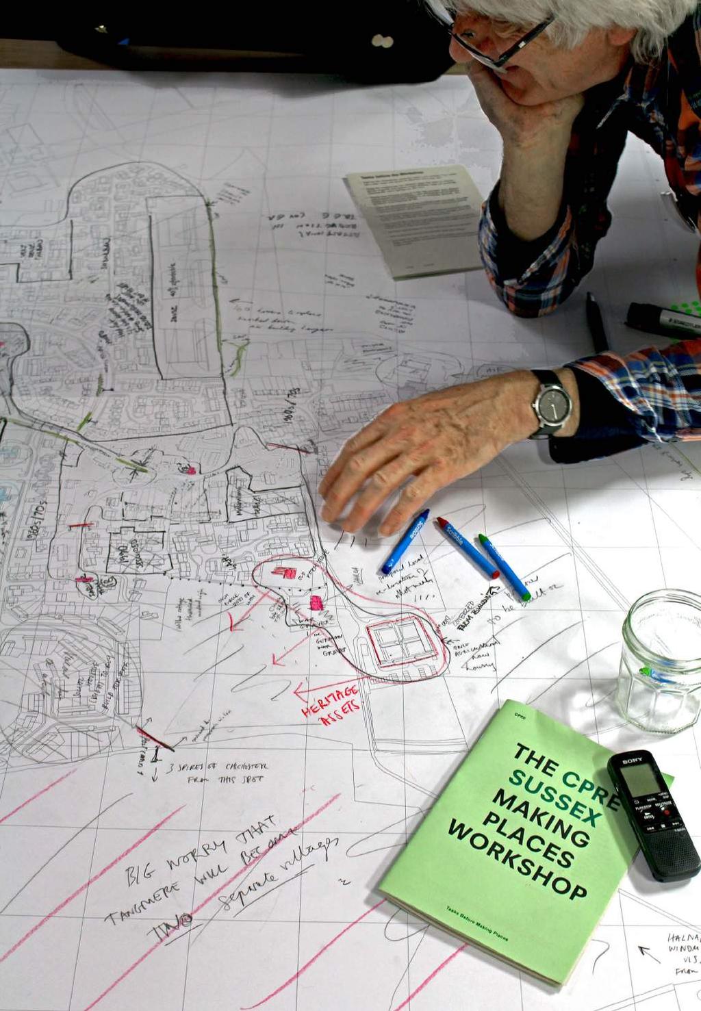
9 CPRE Issue 01 THE CPRE SUSSEX MAKING PLACES WORKSHOP Tasks Before Making Places
10 Making Places Tasks and Ideas to Consider before the Workshop All the information that will go into the Making Places Charter should try to answer the following two questions: What is the distinctive character of the settlement and its buildings in terms of size, shape, proportion, scale and materials? How should these objective and subjective characteristics inform the design decisions of architects, developers, planners, householders and highways authorities? To organise the responce we will consider what makes a place using the following three categories: 1 Settlement Context and Character 2 Settlement Pattern 3 Settlement Buildings 2 These three headings will form the basis of the workshop exercises. It is hoped this notebook will act as guide for these group conversations.
11 Sussex Village
12 Character Assessment 1 Settlement Context and Character What is the character of the surrounding countryside? Are there a number of different landscapes defined by varying qualities? Is there a particular view between the landscape and village that should be preserved? Does the village have a distinctive silhouette when seen from the landscape? How visible is the village from the landscape? It could be a particular characteristic that the village is largely hidden, or quite the reverse in other areas. What are the edges of the village like and how does the edge vary around its perimeter? Consider how common areas, wildlife habitats, ponds, trees and hedgerows are characteristically integrated into the settlement. Consider also how tree lines, green spaces or hedges pass from the landscape into the village. Does your village have associations with historic activities or events? Could these influence future changes to the built environment? Is your village strongly associated with current activities that are important to its character?
13 Landscape
14 Character Assessment 2 Settlement Pattern Examine the characteristic settlement pattern and consider if the village has a clear shape that should be respected and preserved? Divide the village/parish into character areas that relate to different periods of growth and consider which character areas are positively characteristic, which are less so, and why? Please mark character areas on to the map provided. Each different area of growth could be shaded in with coloured pencils or hatches. Please don t worry if your analysis is not completely accurate. Your perception is as important as fact. Define the characteristic qualities of valued roads and lanes. Consider noting and photographing the presence of kerbs, pavements, paving materials and details, street trees. Note and photograph any important edges between character areas or along roads: verges, ditches, banks, boundary hedges, walls and fences. Are these features managed appropriately? How have modern highway engineering and traffic control measures changed the nature of the road network? Identify these and say how a sense of place might be restored. Are there opportunities for locally distinctive paving materials? How is parking currently incorporated within the village? How does the road network link with footpaths and bridleways? Are these characteristic connections or are footpaths and bridleways fragmented?
15 Pattern
16 Situations

17 Character Assessment 3 Settlement Buildings First identify the range of building types that contribute to the characteristic appearance of the village. You may do this by taking photos of all characteristic buildings and then sorting them into groups of similar buildings, scoring each for its local distinctiveness out of 10. Include as many people as possible in this exercise. For each group consider the following: Within which village component can this building type be found and roughly in what numbers/proportions? Does the building tend to be positioned in a certain part of the component or is its location quite random? Whether the building type is typically built right up against the street, at the back of the pavement or set back with front gardens? What are the materials used for the construction of the front elevations of this building type? If there is a mix of materials on an individual building, how is this done? How do the materials used for front elevations differ from those used on publicly visible side and rear elevations? Can you identify a hierarchy of materials? Do chimneys have characteristic positions or details? How are door and window openings typically arranged over the front elevation? Do the building types have characteristic boundary treatments (hedges, walls, fences & railings)?
18 Situations with Buildings

19 Layers

20 97 Will Anderosn running Settlement Buildings at Barnham Community Hall - Jan 2016

21 61

22 Tom Warder and Mara Weiss running Settlement Components at Barnham Community Hall - Jan
23 26

24 13 Boxgrove. Church Lane. A characterful edge and link.

25 15 Boxgrove. The Street. An adapted / adopted green.

26 27 Tangmere. St. Andrews Tangmere. A historic-green-belt.

27 Church 36. Aldingbourne. Giulio Church Paolini Road. Et. Exposure Quid. amab. to the landscape. nisi, qoud 1986 Will Anderson London 39 21

28 Ivy Ln St Richards Rd Westergate. St Richards Road. Relationship with the landscape. 43

29 75 Seaford. Hindover Road. Residential Alleys.
30 Transcript Newhaven LOCATION Hillcrest Community Centre PARTICIPANTS Newhaven Town Council SETTLEMENT CONTEXT CPRE: So, shall we talk about views into and from the town? Newhaven: That will be the incinerator then! What you need to understand is that the new development areas in Newhaven have some of the best views in the country. This land is very visible and a view is a two way responsibility. All the proposals coming forward are just more cheap bad housing on land that is used by Newhaven s residents to break out onto the cliff tops and the downs. For example if you go to the Norman Church you can see Lewes Castle. Newhaven is the Ouse Valley and its edges are exposed to a very special landscape. This is being totally ignored by district council and developers. CPRE: Do people have direct contact with the sea and shoreline? Newhaven: Not really any more. More the river. Most people move to Newhaven now because they can get more house for their pound. There used to be the sandy beach but not any more. There is the Tidemills over to the east but that is a shingle beach maintained by the Environment Agency to mitigate long shore drift locally. This is a place formed by light industry and fishing and infrastructure. Our problem now is one of narrative. The story is always negative, a negative place and a negative reaction to negative development. Saying this is what we are about and these are the steps to achieve it is very difficult. How can a Bilbao effect work here when there is no masterplan or any governmental body taking responsibly? Adding poor quality housing to the edges of a dysfunctional town centre will not build a community. It can t. The organisations involved are so fragmented and off-hand with us that a resident-led plan looks irrelevant if not impossible. We need a narrative and then we need a vehicle capable of pulling everyone s interests together so this town stops being a site of contest between so many different agencies operating in a total policy vacuum - caused by the district council. But Newhaven does have so much to offer, it used to have facilities like the famous London and Paris Hotel, so it can have a national presence if only an economic plan could be put together, and this plan would need to pull together our dispersed community that don t really have anything to do with the town anymore. SETTLEMENT PATTERN Well one thing about Newhaven is that it is hard to move around due to the garotte: the bridge and one -way system. But you can walk out of Newhaven quite quickly so it feels very joined to the countryside. You have the very important green space to the west of The Academy, and the Ouse Valley Nature Reserve, which is hard to walk in, and then the Ouse to the north up to Piddinghoe which is delightful. That area is the first part of the Egrets Way. The problem is with increased development on the west side of the river that will make it harder and harder to access the countryside. Bus access to the east side of the river and the Ouse Valley is v poor so people could be trapped. The Port Authority have also locked off our beach, a beautiful sandy beach, which we can t get to any more. The best example of how we might want all those new houses to be arranged can be seen next to the little recreation ground at Norton Road. These are very sweet. The retail centre we have is really Sainsbury s which is basically out of town. You have to remember that the garotte may look like a town centre but it is not. We used to have all wonderful little shops but it is now dead. You have to also remember that Newhaven doesn t have discretionary spenders. We have 5 pelican crossings and an underpass to the centre but it still doesn t work. What if we say this: why not actually raze the whole centre? Knock it down and allocate it for residential. What would you lose? Nothing. The traffic plan wont change so we need to change what is within the road system. We re going to phone up Kim Jong-un! 59
31 Notes. Context 01 SPECIAL VIEWS Newhaven is located at the mouth of the Ouse Valley where the South Downs rise above the river on both banks. Above the port - residential streets contour across the slopes with views across the river valley and north to Lewes Castle. These views were described by the town council as some of the best views in the country. Views are a two-way responsibility and development must respect this. 02 BREAK OUT Housing developments are proposed for downland that is used by Newhaven s residents to walk out onto the cliff tops and the downs. This downland boundary is a special landscape and very characteristic to the town. The ability to break out and quality of the access routes are both key design principles under threat. 03 BLOCKED BEACH Newhaven has 2 beaches. The West Beach and the Tidemills. The West Beach was closed in 2008 by the owners of Newhaven Port and Properties. The beach has been closed for public safety. The town council have campaigned for a public right of way down to the beach and village green status. This campaign was only partially successful and the beach is still closed. The Tidemills beach is difficult to access from the town and separated from any facilities. The legal definition of a village green is an area of land where local people indulge in lawful sports and pastimes. 04 PROTECTED PARKS There are two important green spaces along the Ouse at Newhaven: the Riverside Country Park and the Ouse Valley Nature Reserve. The Country Park is a unique largely brownfield site connected to the wetlands of the lower Ouse Estuary. At the centre of the park is a football pitch and playground and there is walking and cycling access along the Ouse. The nature reserve has very limited walking and is difficult to reach on foot. 05 NO NARRATIVE Newhaven is a town formed by light industry, fishing and infrastructure links. The town s history and geography is vivid but its present character limited by reputation. The town council believe this due to a lack of positive narrative: the story is always negative, a negative place and a negative reaction to negative development. 64

32 Rural Partnership Event: Launch at the RIBA
WELCOME. Land North of STEVENAGE. We would like to thank you for attending our public exhibition today.
 WELCOME We would like to thank you for attending our public exhibition today. The purpose of this event is to share our proposals and hear your thoughts on our ideas. Members of the project team are on
~~ ~~ ~~ In this lesson, students explore their route to school, observing building types, street layouts and public spaces along the way.
 ~~ ~~ ~~ NEIGHBOURHOOD, VILLAGE, TOWN, CITY..,. p~-~~ Lesson 2: Buildings, Streets and Public Spaces In this lesson, students explore their route to school, observing building types, street layouts and
Welford-on-Avon Neighbourhood Plan Consultation Event Sunday, 6 April Your name Your address
 Welford-on-Avon Neighbourhood Plan Consultation Event Sunday, 6 April 2014 Your name Your email address Please either: - complete this feedback form and put it in the box before leaving the Memorial Hall
To secure a Green Belt around Cambridge whose boundaries are clearly defined and which will endure for the plan period and beyond.
 4. GREEN BELT OBJECTIVES GB/a GB/b GB/c GB/d To secure a Green Belt around Cambridge whose boundaries are clearly defined and which will endure for the plan period and beyond. To maintain the purposes
Kibworth Harcourt. Introduction. Introduction
 Introduction Introduction Welcome to this public exhibition on the proposals for the delivery of new homes on land at The Kibworths. The purpose of today s exhibition is to give you the opportunity to
Hampton Park North Littlehampton West Sussex
 North Littlehampton West Sussex SUMMARY Summary An opportunity to create a new community in West Sussex on the northern outskirts of Littlehampton with outstanding views across open countryside towards
LONGDEN VILLAGE DEVELOPMENT STATEMENT
 LONGDEN VILLAGE DEVELOPMENT STATEMENT 2017-2027 1 Longden Development Statement 2017-2027 15/01/18 1. Background 1.1 Longden Village Longden village is a very rural and traditional community first mentioned
SITE ASSESSMENT CHECKLIST
 1. Site Details a. What is the site s name/reference? SITE ASSESSMENT CHECKLIST CR3NPWHY 3007 Gasometer Site Godstone Road CR3 0EG b. Where is the site located? Wyhteleafe; Godstone Road. Urban category1
SETTLEMENT ASSESSMENT PROFORMA
 SETTLEMENT ASSESSMENT PROFORMA Surveyors(s):Clare Sheridan Character Area: Park Estate = Midland Rd, Severn Rd, Festival Rd, Park Rd, Willow Rd, Rylands Rd. Date: Feb Weather: cloudy Look through all the
Local Green Space. Site: Land surrounding All Saints Church and the recreation grounds, Earls Barton Site Appraisal: 02/12/13 Site Code: LGS1
 Local Green Space Site: Land surrounding All Saints Church and the recreation grounds, Earls Barton Site Appraisal: 02/12/13 Site Code: LGS1 Original Source es o Existing Local Plan Designation Suggested
What do you like about South Marston?
 What do you like about South Marston? What you have said so far: Strong and separate identity, distinct from Swindon Village character (Church, School, Green and Hall) Surrounding working countryside and
Streets for All East of England
 Streets for All East of England Summary In 2017 Historic England published an updated national edition of Streets for All, a practical guide for anyone involved in planning and implementing highways and
Public Consultation. Land at Monks Farm, North Grove. Welcome
 Welcome Welcome to our public exhibition for development on Land at Monks Farm, orth Grove. Gallagher Estates and Gleeson Strategic Land are preparing an outline planning application for new homes, open
8.0 Design and Form of Development 43/
 42/ 8.0 Design and Form of Development 43/ Rothwells Farm, Golborne/ Development Statement Figure 7. Site Constraints Key 44/ Site Boundary 360 Bus Route/Stops Existing Trees Underground Water Pipe Sensitive
PDP DESIGN & ACCESS STATEMENT
 PDP The Planning & Design Partnership Planning.. Architecture.. Interiors.. Landscape The Chicory Barn Studio, The Old Brickyards, Moor Lane, Stamford Bridge York, The East Riding Of Yorkshire, YO41 1HU.
Statement of Community Involvement LAND OFF SOUTHDOWN ROAD HORNDEAN, HAMPSHIRE
 LAND OFF SOUTHDOWN ROAD HORNDEAN, HAMPSHIRE CONTENTS Page 1. Introduction 3 2. Pre-application Discussions 4 3. The Consultation Process 5 4. Consultation Feedback 7 5. Responses to Consultation Feedback
1.0 INTRODUCTION. Brantham Industrial Area Regeneration - Factory Lane - Brantham
 1.0 INTRODUCTION Welcome to this exhibition of our proposals for the regeneration of the Brantham Industrial Area located off Factory Lane in Brantham. This presentation will give you an opportunity to
Tāhuhu whakaruruhau ā-taone The sheltering ridge pole
 B2. Tāhuhu whakaruruhau ā-taone - Urban growth and form B2.1. Issues Tāhuhu whakaruruhau ā-taone The sheltering ridge pole Auckland s growing population increases demand for housing, employment, business,
Ashtead Neighbourhood Forum Site Assessment AS07 Old Chalk Pit, Pleasure Pit Road. Site ref: AS07 Site address: Old Chalk Pit, Pleasure Pit Road
 Site ref: AS07 Site address: Old Chalk Pit, Pleasure Pit Road Proposed Land Use: Total Site Area (Ha): Housing 0.7ha Description: The site was formally an old chalk pit that has been partially filled and
The Gwennap Parish Vision Statement
 QUICK GUIDE What is a Neighbourhood Development Plan? Ultimately it is a document used by developers or anyone wishing to submit a planning application that describes the vision, strategy, plans, regeneration,
9 Pershore. Introduction. Pershore Abbey
 118 Introduction 9.1 The historic town of Pershore lies on the River Avon and has a population of 7,000 (2009 Mid-Term Population Estimates). The main areas of the town are centred on the Abbey, the bustling
PONTELAND NEIGHBOURHOOD PLAN LANDSCAPE QUALITY ASSESSMENT
 PONTELAND NEIGHBOURHOOD PLAN LANDSCAPE QUALITY ASSESSMENT UPDATED CONSULTATION ISSUE NOVEMBER 2016 CONTENTS 2 Introduction 2 Methodology 4 Landscape Quality Areas Plan 5 Landscape Quality Area 1 SMALLBURN
Draft Submission of Chilcompton Parish Council to Mendip Local Plan
 Draft Submission of Chilcompton Parish Council to Mendip Local Plan Note: This is a draft for consultation. The Parish Council urges all villagers and other stakeholders to send comments to: parishclerk@chilcompton.org.
Your web browser (Safari 7) is out of date. For more security, comfort and the best experience on this site: Update your browser Ignore
 is out of date. For more security, comfort and the best experience on this site: Update your browser Ignore") Your web browser (Safari 7) is out of date. For more security, comfort and the best experience on this site: Update your browser Ignore HEDGES O F BIO DIVERSITY Historic English hedgerows foster biodiversity
Your web browser (Safari 7) is out of date. For more security, comfort and the best experience on this site: Update your browser Ignore HEDGES O F BIO DIVERSITY Historic English hedgerows foster biodiversity
3. Neighbourhood Plans and Strategic Environmental Assessment
 1. Introduction This report sets out a draft Screening Determination for the Preston Parish Council s Neighbourhood Plan and has been prepared by rth Hertfordshire District Council. The purpose of the
Ashtead Neighbourhood Forum Site Assessment AS14 Land at The Pines, Farm Lane. Site ref: AS14 Site address: Land at The Pines, Farm Lane
 Site ref: AS14 Site address: Land at The Pines, Farm Lane Proposed Land Use: Total Site Area (Ha): Housing 2.1ha Description: The site is located to the east of Ashtead off Farm Lane and is currently grassed.
A VISION FOR BLAIRGOWRIE
 Welcome to the Westpark Partnership and Lidl UK GmbH Community Presentation. The purpose of this presentation is for you to view and comment upon the revised and updated proposals for the allocated development
North Littlehampton Community Newsletter 3 February 2011
 North Littlehampton Community Newsletter 3 February 2011 New Prospects for North Littlehampton Planning Application submitted It is now just over two and a half years since members of the community participated
Neighbourhood Planning Site Assessment Pro-forma and Guide Version 2
 Neighbourhood Planning Site Assessment Pro-forma and Guide Version 2 September 2014 Site HNP 006 Land East of Stanbridge Road and North of Lower Road 1. Background information Site location and use Site
Neighbourhood Plan Representation
 Date: 10 th November 2017 Neighbourhood Plan Representation Land to the east of Callow Hill Road, Alvechurch Introduction This representation has been prepared by RPS Planning and Development on behalf
INTRODUCTION NORTH HEYBRIDGE GARDEN SUBURB
 INTRODUCTION This event is being hosted by the promoters of the proposed North Heybridge Garden Suburb who are working with Maldon District Council and other key stakeholders on the preparation of a comprehensive
Plan Modification to Chapter B2 of the Auckland Unitary Plan(AUP) Operative in part (15 November 2016)
 Operative in part (15 November 2016)") UNITARY PLAN UPDATE REQUEST MEMORANDUM TO FROM Phill Reid Linley Wilkinson DATE 25 September 2018 SUBJECT Plan Modification to Chapter B2 of the Auckland Unitary Plan(AUP) Operative in part (15 November
UNITARY PLAN UPDATE REQUEST MEMORANDUM TO FROM Phill Reid Linley Wilkinson DATE 25 September 2018 SUBJECT Plan Modification to Chapter B2 of the Auckland Unitary Plan(AUP) Operative in part (15 November
Welcome. Welcome to our first Open Day event
 Welcome We are here Welcome to our first Open Day event About us This is the first of many opportunities to have your say on the development of the. Urban&Civic was founded specifically to enable and deliver
Planning and Sustainability Statement
 Land adjacent to Manor Farm, Catterick Village Pallett Hill Sand and Gravel Co Ltd Proposed 10 new dwellings, (6 No market dwellings and 4 No affordable dwellings) with access, associated car parking and
Bayswater Town Centre Structure Plan. Visioning Workshop. October 2016
 Bayswater Town Centre Structure Plan Visioning Workshop October 2016 Bayswater Town Centre Structure Plan Visioning Workshop The Project Process 1 2 3 4 5 6 7 Background Research & Analysis Establish Community
Neighbourhood Planning Guidance Local Green Spaces
 Neighbourhood Planning Guidance Local Green Spaces Introduction This guidance note has been produced for communities preparing neighbourhood plans in North Dorset to help them to identify, assess and designate
Regional Context Statement
 Regional Context Statement REGIONAL CONTEXT STATEMENT 3. REGIONAL CONTEXT STATEMENT In 1995, the Provincial Government passed into law the Growth Strategies Act. The purpose of this provincial initiative
Land at Fiddington Hill Nursery, Market Lavington
 Land at Fiddington Hill Nursery, Market Lavington Briefing Report for Market Lavington Parish Council Persimmon Homes (Wessex) April 2016 Background This brief report has been prepared following the Market
Newcourt Masterplan. November Exeter Local Development Framework
 Newcourt Masterplan November 2010 Exeter Local Development Framework Background The Exeter Core Strategy Proposed Submission sets out the vision, objectives and strategy for the development of Exeter up
March General enquiries: Web site:
 REDEVELOPMENT OF WILSON HOSPITAL FOR MITCHAM LOCAL CARE CENTRE Community Planning & Design Brief for Merton Clinical Commissioning Group and London Borough of Merton March 2016 1. Mitcham Cricket Green
Stratford Neighbourhood Plan Questionnaire
 Stratford Neighbourhood Plan Questionnaire Please tick the appropriate box or answer in the space provided. If you require further copies of the questionnaire, as more than one person in the household
White Cottage Cardinal s Green Horseheath Cambridge CB21 4QY
 White Cottage Cardinal s Green Horseheath Cambridge CB21 4QY Step inside White Cottage An attractive detached cottage delightfully situated in secluded gardens of about 1/3 acre with views at the rear
Longhorsley Neighbourhood Plan
 Site Assessment 1. The availability of the site 1.1 Is the land owner willing for their site to be made available for development? 1.2 If yes, do you have any written evidence to back this up? Planning
Billington Parish Green Infrastructure Plan
 Billington Billington Parish Green Infrastructure Plan Methodology Following a presentation to the Annual Parish Meeting, The Greensand Trust was invited to attend the next Parish Council Meeting. The
Neighbourhood Planning Local Green Spaces
 Neighbourhood Planning Local Green Spaces Introduction... 2 1. Why green space is important... 4 2. Neighbourhood plans and green space... 6 3. Evidence... 8 Statutory designations... 9 Green space audit...
ARLESEY CONSULTATION QUESTIONNAIRE
 ARLESEY CONSULTATION QUESTIONNAIRE Arlesey Welcome to the first public exhibition in relation to the outline masterplan proposals for development at land at Chase Farm and land west and north-east of High
1. Local Plan Context
 1. Local Plan Context WHY ARE YOU HERE? ABOUT US PLANNING APPLICATION CONSULTATION Stewart Milne Homes are in the process of preparing a detailed planning application for a development of approximately
By to: 30 March Thank you for the opportunity to respond to this important consultation.
 70 Cowcross Street London EC1M 6EJ Tel: 0207 253 0300 Fax: 0207 490 3001 office@cprelondon.org.uk www.cprelondon.org.uk Environment, Housing & Regeneration London Borough of Sutton 24 Denmark Road Carshalton
Our City Centre is a vibrant, creative and welcoming destination, with a modern business, cultural, shopping, leisure and residential offer
 3. Sheffield in 2034 Our City sits at the heart of a strong, distinctive and internationally successful City Region economy which supports innovation and enterprise Our City Centre is a vibrant, creative
Site Assessment Technical Document Appendix A: Glossary
 Central Bedfordshire Council www.centralbedfordshire.gov.uk Site Assessment Technical Document Appendix A: Glossary July 2017 1.1.11-1 - ii Appendix A: Glossary Term Agricultural Land Classification AONB
CLEVE PARK, THORNBURY
 CLEVE PARK, THORNBURY Community Planning Day Report Back Broadsheet February 206 A VISION FOR CLEVE PARK Over 0 local people attended the Cleve Park Community Planning Day at Armstrong Hall on Saturday
SOUTH EAST LINCOLNSHIRE LOCAL PLAN: HOUSING PAPER DONINGTON (JUNE 2016)
") SOUTH EAST LINCOLNSHIRE LOCAL PLAN: HOUSING PAPER DONINGTON (JUNE 2016) 1 DONINGTON S PLACE IN THE SPATIAL STRATEGY 1.1 Policy 2 of the South East Lincolnshire Local Plan 2011-2036 Draft for Public Consultation
SOUTH EAST LINCOLNSHIRE LOCAL PLAN: HOUSING PAPER DONINGTON (JUNE 2016) 1 DONINGTON S PLACE IN THE SPATIAL STRATEGY 1.1 Policy 2 of the South East Lincolnshire Local Plan 2011-2036 Draft for Public Consultation
Rochford District Council Allocations Development Plan Document: Discussion and Consultation Document Sustainability Appraisal
 Option SWH1 Balanced Communities Option SWH1 1 To ensure the delivery of high quality sustainable communities where people want to live and work Will it ensure the phasing of infrastructure, including
Creating Complete Roadway Corridors:
 Creating Complete Roadway Corridors: The AASHTO Guide to Transportation Landscape Architecture and Environmental Design NCHRP Project 15-33 Status Report AASHTO Standing Committee on Design Technical Committee
A BEAUTIFUL PLACE FOR LIVING
 A BEAUTIFUL PLACE FOR LIVING BEAULIEU: A PLACE FOR LIFE Beaulieu is a vibrant new district taking shape in Chelmsford, Essex; offering residents inspirational architecture and landscape. Developers Countryside
DEVELOPMENT MANAGEMENT REPORT
 ITEM A08-1 DEVELOPMENT MANAGEMENT REPORT TO: BY: DATE: DEVELOPMENT: SITE: WARD: APPLICATION: APPLICANT: Development Management Committee Development Manager Proposed live/work unit in connection with existing
EXTRACT FROM THE CUDDINGTON NEIGHBOURHOOD PLAN The Policies
 EXTRACT FROM THE CUDDINGTON NEIGHBOURHOOD PLAN The Policies Environment and Landscape Policy 1 - Landscape Setting Development should respect and wherever possible enhance the landscape setting of Cuddington
Rural Land Use Designations Kittitas County December 6, 2007 Draft
 KITTITAS COUNTY COMMUNITY DEVELOPMENT SERVICES 411 N. Ruby St., Suite 2, Ellensburg, WA 98926 CDS@CO.KITTITAS.WA.US Office (509) 962-7506 Fax (509) 962-7682 Rural Land Use Designations Kittitas County
6 PORT SYDNEY SETTLEMENT AREA
 Section 6 Port Sydney Page 61 6 PORT SYDNEY SETTLEMENT AREA 6.1 Basis and Principles Village of Port Sydney Waterfront Community Existing Services 6.1.1 Port Sydney is an historic settlement that has developed
Creating places people love tegic Land Stra
 Strategic Land Creating places PEOPLE LOVE Creating Places People Love Countryside creates places of character and quality, where people aspire to live and where they feel a true sense of belonging. 1
The eight-week period for this application expires on 5 October 2006.
 06/01213/FUL CHANGE OF USE FROM AGRICULTURAL LAND TO PRIVATE CAR PARK AND NEW FENCING. AT Land To The South of Perceval Almhouses, Lower Weald, Calverton FOR Calverton Parochial Church Council INTRODUCTION
Local Plan Representation Appendices
 Local Plan Representation Appendices ID: 862, 863, 864, 865, 866, 867, 868, 968, 870 Church Commissioners for England Land Ownership at North Bersted, Bognor Regis Church Commissioners for England Land
WELCOME TO THE NEW WILTON PARK
 WELCOME TO THE NEW WILTON PARK VISION HISTORY OF WILTON PARK TOWARDS A PLANNING APPLICATION Our objective is to create a truly outstanding environment at Wilton Park. At the heart of our proposals is a
Wildlife and Planning Guidance: Neighbourhood Plans
 Wildlife and Planning Guidance: Neighbourhood Plans This Leaflet is one of a series of 4 Wildlife and Planning Guidance Leaflets and is intended to provide useful information to assist you to campaign
Olympics. Large areas of the Lower Lea Valley have now been taken for the Olympics and surrounded by tall blue fences.
 Olympics December 2007 Update. Large areas of the Lower Lea Valley have now been taken for the Olympics and surrounded by tall blue fences. White Hart Field and small pockets of open space along Waterden
Laberge Group. Town of Coeymans. Draft Comprehensive Plan. Overview of Planning Process
 Draft : Presentation of Goals & Strategies Laberge Group Benjamin H. Syden, A.I.C.P., E.D.P Director in Charge Nicole Allen, A.I.C.P. Senior Planner Anjali Malhotra Planner Presentation Outline Introductions
Ashtead Neighbourhood Forum Site Assessment AS03 Lime Tree Lodge, Farm Lane. Site address: Lime Tree Lodge, Farm Lane. Proposed Land Use:
 Site ref: AS03 Site address: Lime Tree Lodge, Farm Lane Proposed Land Use: Total Site Area (Ha): Housing 1.25ha Description The site is located off Farm Lane at the junction with Park Lane. To the north
Landscape Guidelines. Landscape type: Valley Pasture Character areas: Frome Valley Pasture Stour Valley Pasture. Landscape change
 Landscape type: Valley Pasture Character areas: Frome Valley Pasture Stour Valley Pasture The valley pasture landscape type is found along the lower reaches of the Stour and Frome, formed from alluvial
Terra Nova Rural Park Plan
 Terra Nova Rural Park Plan Part 1 Getting to know the land The Surrounding Area North Side Airport, River, Trail East Side - Residential West Side- Sturgeon Banks, West Dyke Trail South Side:Terra Nova
Healthy by Design Tasmanian Edition Ella Ashley - Project Manager, Heart Foundation Robert Giblin Project Consultant, Planner
 Healthy by Design Tasmanian Edition Ella Ashley - Project Manager, Heart Foundation Robert Giblin Project Consultant, Planner 2008 National Heart Foundation of Australia Planning and Health The way we
How important is it to use our Neighbourhood Plan to try to find ways of improving the natural environment of the Parish?
 Question 15 Landscape and nature: How important is it to use our Neighbourhood Plan to try to find ways of improving the natural environment of the Parish? If you think it s important, where in the parish
17. Coolaney-Rockfield Mini-Plan
 County Development Plan 2017-2023 Consolidated Draft + Adopted Amendments - August 2017 17. Coolaney-Rockfield Mini-Plan Village profile Coolaney is located approximately 23 km to the south-west of Sligo
Accreditations. Who are Burleys? Who are TCL Group?
 Accreditations No compromise. All of our activities are certified to a high standard within the relevant industry areas. Who are Burleys? Burleys offer grounds maintenance and estate management services
Toddington Central Bedfordshire Stage 3 Green Belt Study December 2017
 Toddington Central Bedfordshire Stage 3 Green Belt Study December 2017 Site: ALP086 - Middle Lakes, Toddington Site size (ha): 2.83 Site: ALP086 - Middle Lakes, Toddington Site size (ha): 2.83 Site description
Slough International Freight Exchange Proposals, Colnbrook+
 Welcome Welcome to this exhibition, which is being held in connection with our proposals for a new freight exchange facility on land to the north of the A4. Please take this opportunity to look at the
LANDSCAPE GUIDELINES. Countryside & Coastal Countryside Environments. Landscape, Natural Character & Amenity Values Guide
 Landscape, Natural Character & Amenity Values Guide Copyright WDC 2009 Version A2 18May09 Environmental Services Group Publication Countryside & Coastal Countryside Environments START HERE Quality Land
Glencullen Local Area Plan 2008
 www.dlrcoco.ie Glencullen Local Area Plan 2008 Economic Development & Planning Department Dún Laoghaire-Rathdown County Council March 2008 Glencullen Local Area Plan 2008 The Glencullen Local Area Plan
Full Name /title*. Address 1. Address 2 Post Code* *.. Phone* *Required fields for draw
 You can return this later to post boxes at: the Parish Council Office, Rowney Green Village Hall, The Petrol Station at Hopwood, or the Library. Closing date 14 th March: Draw on 14 th April 2014 at Alvechurch
WELCOME GYPSY LANE. Wider Site Location plan. Proposals for the development of LAND OFF FOXLYDIATE LANE WEBHEATH. Proposals for the development of
 WELCOME The developers are preparing an outline planning application for a residential led development and need the community s views in order to develop the proposals further WHAT IS PROPOSED? A high
B - Coalfield River Corridor Landscape Character Type
 B - Coalfield River Corridor Landscape Character Type Landscape Character Type - Coalfield River Corridor The Coalfield River Corridors Landscape Character Type is located in the two converging valleys
Describing Places- Adjective Word Order
 Describing Places- Adjective Word Order Work in groups of two or three. Take turns describing an imaginary natural place (each), one sentence at a time. Use as many adjectives as you can in each sentence,
A Growing Community Rural Settlement Areas
 Town of Huntsville Official Plan Review - POLICY BACKGROUND PAPER A Growing Community Rural Settlement Areas BACKGROUND: In addition to the fully municipally-serviced Urban Settlement Area and the Hidden
Moreno Valley College: Conceptual Master Planning - Site Analysis Lasselle Street, Moreno Valley, CA 92551
 Master Plan Architect School Name Moreno Valley College District Riverside Community College District Architecture and Urban Design 5898 Blackwelder Street Ground Floor Culver City, CA 90232 T: 310.559.5720
The Villages. Cliffe Cottage Port Lympne
 Cliffe Cottage Port Lympne #TheGardenOfEngland Cliffe Cottage Port Lympne Aldington Road, Lympne, Kent CT21 4LN A charming detached character farmhouse with 2 double bedrooms, 2 reception rooms and lovely
Mill Conversion Overlay District Zoning Bylaw Amendment
 Mill Conversion Overlay District Zoning Bylaw Amendment To see if the Town will vote to amend the Zoning By-Law by adding a new Section 13, Mill Conversion Overlay District, and by amending Sections 2.1,
CLIVE RAND, MASTERPLANNING PARTNER, BARTON WILLMORE ARCHITECTS:
 CLIVE RAND, MASTERPLANNING PARTNER, BARTON WILLMORE ARCHITECTS: EASTERN QUARRY: FORM AND CONTENT FOR A NEW URBAN VILLAGE Ashford Conference, 12 November 2003 Building for Life 2004 EASTERN QUARRY Clive
New Bolton Woods Cricket Club
 New Bolton Woods Cricket Club 1 1. New Bolton Woods Partnership Area What IS THIS ALL ABOUT? New Bolton Woods Ltd is a development partnership between regeneration company Urbo and Bradford Council. It
Wild about Bolnore. Welcome to Bolnore Village, situated in the beautiful West Sussex countryside. ResIDENTS INFORMATION GUIDE
 Wild about Bolnore Welcome to Bolnore Village, situated in the beautiful West Sussex countryside. Sustainability has been a key factor in the development of the village and considerable effort has been
Site ref: AS06 Site Name or Address: Murreys Court, Agates Lane
 Site ref: AS06 Site Name or Address: Murreys Court, Agates Lane Proposed Land Use: Total Site Area (Ha): Housing 1.85 Ha Description: It is understood that the owner has no plans to dispose of the site
Great Easton Neighbourhood Plan Statement of Basic Conditions
 Great Easton Neighbourhood Plan 2017-2031 Statement of Basic Conditions OCTOBER 2016 GREAT EASTON PARISH COUNCIL Contents 1.0 Introduction....Page 2 2.0 Summary of Submission Documents and Supporting Evidence..
East Harptree Landscape & Character Assessment
 East Harptree Landscape & Character Assessment Produced by East Harptree Parish Council in consultation with local residents September 2014 Contents The Parish of East Harptree: Objective Introduction
PLACE WORKSHOP REPORT. A+DS SNH sustainable placemaking programme
 PLACE briefing WORKSHOP REPORT A+DS SNH sustainable placemaking programme INTRODUCTION This report summarises the outcome of a Scottish Natural Heritage workshop on placemaking which was held on Wednesday
DESIGN AND MANAGEMENT PART 3 HA 57/92 NEW ROADS INTEGRATION WITH RURAL LANDSCAPES SUMMARY
 DESIGN MANUAL FOR ROADS AND BRIDGES VOLUME 10 SECTION 1 ENVIRONMENTAL DESIGN AND MANAGEMENT NEW ROADS PART 3 HA 57/92 NEW ROADS INTEGRATION WITH RURAL LANDSCAPES SUMMARY This Advice Note gives guidance
Sawtell Town Centre Development Control Plan
 Sawtell Town Centre Development Control Plan ABN 79 126 214 487 CONTENTS INTRODUCTION... 1 PREAMBLE... 1 HOW TO USE THIS DCP... 1 LAND TO WHICH THIS PLAN APPLIES... 1 MASTERPLAN... 2 VISION... 2 CHARACTER
Public Consultation 23 January Peel Hall, Warrington Board 1. A message from Satnam... Site history...
 Board 1 A message from Satnam... Thank you for attending today s public consultation about proposals to develop a new residential neighbourhood at. The display boards show why the development is needed
Environmental and Landscape Mapping
 Environmental and Landscape Mapping In support of the Calveley Neighbourhood Plan November 2016 Project Name and Number: Calveley Neighbourhood Plan 16-025 Document Name and Revision: Environmental and
E. RURAL COMMERCIAL/INDUSTRIAL PARK MODEL
 E. RURAL COMMERCIAL/INDUSTRIAL PARK MODEL 1. PURPOSE The purpose of the Rural Commerce/Industrial Park Model is to provide parameters within which a grouping of business buildings with parking, loading
Story Homes. Land at Thirsk Road, Kirklevington. An Introduction to Story Homes. Our Foundations. Commitment to Consultation.
 Story Homes An Introduction to Story Homes Founded by Fred Story in 1987, Story Homes has a long and successful reputation of building high quality and high specification homes. The family owned business
Schedule of Planning Applications Committee Date: 23 May Reference: 06/17/0726/F Parish: Hemsby Officer: Mr J Beck Expiry Date:
 Schedule of Planning Applications Committee Date: 23 May 2018 Reference: 06/17/0726/F Parish: Hemsby Officer: Mr J Beck Expiry Date: 22-05-2018 Applicant: Proposal: Site: Mr Gillett Change of use to the
I403 Beachlands 1 Precinct
 I403. Beachlands 1 I403.1. Precinct Description Beachlands is a rural and coastal village located on the eastern side of Auckland, adjoining the Tamaki Strait coastline. The original Beachlands village