Freeway Land Property Industrial Site Assessment
|
|
|
- Charleen Philomena Collins
- 6 years ago
- Views:
Transcription
1
2

3 Freeway Land Property Industrial Site Assessment Presented to Portland Development Commission By January 10, 2007
4
5 Table of Contents 1.0 Site Background Site Characteristics Industrial Market Overview Freeway Land Competitive Analysis...32 Appendix A...3
6
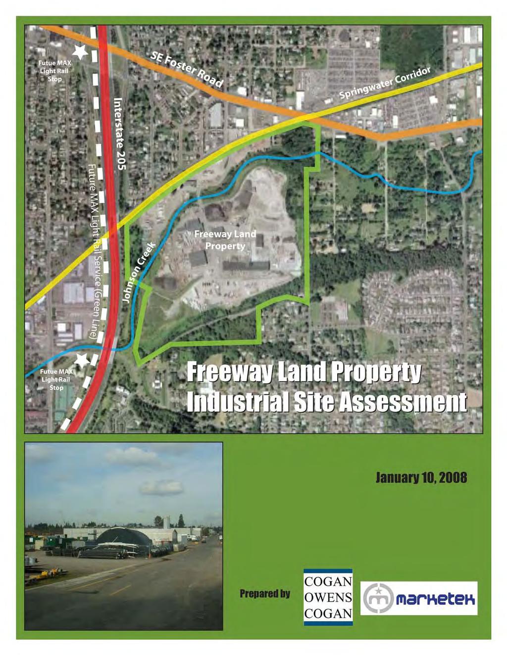
7 Freeway Land Property Industrial Site Assessment The purpose of this industrial site assessment is to describe the current status of the Freeway Land site, identify physical and market issues and opportunities, and assess the site s overall suitability for various industrial uses. The report is organized as follows: Section 1.0: Site Background. Overview and history of the Freeway Land site. Section 2.0: Site Characteristics. Description of physical characteristics, regulation and environmental issues associated with the site. Section 3.0: Industrial Market Assessment. Assessment of the Portland Metropolitan Area s suitability for industrial development. Section 4.0: Site Competitive Analysis. Analysis of competitive strength of the Freeway Land site for industrial purposes. 1.0 Site Background The Freeway Land property lies in Outer Southeast Portland in the Lents neighborhood. It currently includes a mixture of vacant areas, natural resources and light industrial uses. Over time, it has been converted to multi-tenant industrial use. Current property owners purchased the site in The property had been for sale during much of the previous 15 years and the City of Portland had considered but not acted on opportunities to buy the property in the early 1990s and in While the property was on the market, it reportedly received significant interest from real estate brokers throughout the West Coast. Significant planning work has been completed in the Lents area since the early 1990s, including creating and implementing the current urban renewal district. Much of that planning has been focused on areas west of Interstate 205 within the Lents Town Center area. Recent plans more directly related to the Freeway Land site include efforts to address flooding associated with Johnson Creek in this area. Those efforts have resulted in floodway mitigation initiatives that directly affect this property and surrounding parcels and commit a certain portion of the property to wetland and flooding mitigation activities. The current property owners see themselves as caretakers of the property with the objective of creating employment opportunities in this area for surrounding residents and others in the region. They have no specific plans to change the use of the property or split it into smaller parcels. They hope to work with the City of Portland, with the City in the lead to plan for appropriate future employment uses as part of a larger strategy for Outer Southeast Portland. Map 1.1 provides overview of the Freeway Land site within the Lents neighborhood: Freeway Land Site Analysis Cogan Owens Cogan, LLC./Marketek, Inc. 01/10/2008 1

8 Map 1.1 Aerial of Freeway Land Property and Vicinity Source: Cogan Owens Cogan, LLC and Google Maps Freeway Land Site Analysis Cogan Owens Cogan, LLC./Marketek, Inc. 01/10/2008 2
9 Policy Goals One of the City s overarching goals for urban renewal efforts in Lents is to increase quality employment opportunities for residents of the neighborhood. The following policy goals embodied in various planning documents for the Lents area focus on increasing employment opportunities in Lents and specifically at the Freeway Land site: Outer Southeast Business Plan (part of Portland Comprehensive Plan) Outer SE Community-Wide Actions: ED4 Assist in the redevelopment of the Freeway Land Development Corporation site for high density employment opportunities Lents Town Center Urban Renewal Plan Goal 5: Employment: Help businesses create family-wage jobs and make jobs available to Lents residents: o Promote development and redevelopment of industrial lands. o Initiate commercial/industrial site marketing efforts. o Support the creation of new businesses by area residents 2001 Lents Town Center Economic Development Strategy Conclusions and Recommendations: Workforce development efforts should focus on four issues: 1. Raising the awareness among Lents residents about the types of family-wage jobs available in the I-205 corridor and the skills required to obtain these jobs. 2. Developing strong working relationships with I-205 business in targeted industry clusters. 3. Developing integrated training programs that offer immediate employment opportunities linked to ongoing training for career advancement. 4. Developing mechanisms that allow people to upgrade skills or education with minimum impact to existing job security. o The greatest potential for primary job creation will be with industrial sites east of the freeway, possibly accompanied by supporting retail/services. Additional potential for job creation exists in commercial areas of downtown Lents. o The area east of I-205 should focus on the creation of primary, family wage jobs. Freeway Land Site Analysis Cogan Owens Cogan, LLC./Marketek, Inc. 01/10/2008 3
10 2.0 Site Characteristics Location The property is located in outer southeast Portland in the Lents neighborhood, directly east of Interstate 205, and south of SE Foster Rd. The official site address is 6400 SE 101 st Avenue, Portland, OR Ownership The site was sold in 2006 to Jameson Partners, LLC for $11.4 million. Owner Address: Jameson Partners, LLC 2495 NW Nicolai St Portland, OR Size Several reports include differing measurements of the acreage of the property, particularly the amount of buildable or partly-buildable acres. This is due, in part, to individual source assumptions in calculating acreage, and the uncertainty of environmental constraints of the site due to Johnson Creek. A summary of estimates provide a range of usable land between 50 and 87 acres. The City of Portland s Industrial Districts Atlas states the site is approximately 114- acres, and includes an estimated 18 acres of buildable, vacant land and another 39 acres of partly buildable vacant land affected by floodplain or habitat constraints. 1 The estimates for both total acres and usable acres differ from other sources, including a 2003 property valuation by PGP Inc., which estimates the site to be total acres, with usable acres. PGP s acreage estimates are summarized in Table 2.1 below: Table 2.1 Freeway Land Site Size (2003) Description Gross (AC) Unusable (AC) Usable (AC) Primary Site Area Improved Portion - Industrial Surplus/Excess Industrial Land Excess Commercial Land (Tax Lot 4900) Residential Land (Tax Lot 400) Total Note: The Primary industrial site area totals acres, of which 81.28acres is usable Source: PGP Valuation, Inc., City of Portland Industrial Districts Atlas Freeway Land Site Analysis Cogan Owens Cogan, LLC./Marketek, Inc. 01/10/2008 4
11 SERA Architects estimated usable acres between 56 and 62 acres in alternative diagrams for Portland Development Commission s (PDC) 2003 Lents Town Center Revitalization Study. 2 The industrial broker for the site states that approximately 68 acres are usable. Johnson Gardener estimated between 50 and 60 developable acres depending on resolution of stormwater retention efforts. 3 Current Use The site is occupied by over 20 different industrial uses including asphalt production and shingles recycling, concrete use, truck repair, and a palette recycler. Approximately 159 employees work at the site. Table 2.2 provides a list of tenants at the site. Table 2.2 Freeway Land Tenants and Number of Employees Company Address SKYLINE ENTERPRISES LLC 6400 SE 101ST AVE STE 2 CASCADE DRILLING INC OREGON 6400 SE 101ST AVE STE 2D APPLY-A-LINE INC 6400 SE 101ST AVE BLDG 41 HAWKES POWER & CONTROLS COMPANY 6400 SE 101ST AVE BLDG 1H LDN EXCAVATION INC 6400 SE 101ST AVE STE 7 CASCADE DRILLING INC 6400 SE 101ST AVE STE 2D RINKER MATERIALS CORPORATION 6400 SE 101ST AVE VIKING METAL GRAFICS 6400 SE 101ST AVE STE 3C MAINLINE ROCK & BALLAST INC 6400 SE 101ST AVE NEW VENTURE MFG. & SERVICE, INC 6400 SE 101ST AVE STE 4D SCHLOTH TRUCK EQUIPMENT CO 6400 SE 101ST AVE SPC B CASCADE PACIFIC TRANSPORTATION INC 6400 SE 101ST AVE STE 1 NELSON TRUCKING CO INC 6400 SE 101ST AVE FEED COMMODITIES LLC 6400 SE 101ST AVE STE 1A FREEWAY LAND COMPANY LLC 6400 SE 101ST AVE HYATT TANKS INC 6400 SE 101ST AVE HAULAWAY STORAGE CONTAINERS INC 6400 SE 101ST AVE NORTHWEST CLERICAL SERVICE 6400 SE 101ST AVE STE 5 SANDERS MOBILE TRUCK REPAIR, INC 6400 SE 101ST AVE STE 2C MACY WELDING 6400 SE 101ST AVE STE 2A A & J QUALITY CONSTRUCTION LLC 6400 SE 101ST AVE STE 8 Source: Oregon Employment Department, Cogan Owens Cogan 2 PDC/SERA Architects, 2003 Lents Town Center Revitalization 3 Baseline Market Analysis for Lents, 2003, Johnson Gardner. Freeway Land Site Analysis Cogan Owens Cogan, LLC./Marketek, Inc. 01/10/2008 5
12 Table 2.3 provides an improvement summary for the site, noting building footprints, gross built-up area (GBA), and the net rentable are (NRA). Table 2.3 Improvements, Freeway Land Industrial Park (2003) Identification Footprint (SF) GBA (SF) NRA (SF) *Office Building 5,166 9,840 7,496 Bldg. 1 35,872 37,672 34,640 Bldg. 2 36,000 36,000 35,841 Bldg. 3 31,870 31,870 25,420 Bldg , , ,350 Total 297, , ,747 *Does not include the basement area Source: PGP Valuation, Inc., 2003 Environmental Status The site has no major documented environmental issues. Records indicated only one small scale incident involving an oil spill of undisclosed size. The site has a small clean-up issue where the previous owner did an illegal fill in the adjacent wetlands near Johnson Creek. This issue is 90% resolved with Corp of Engineers. Final work cannot be done until next summer, after which mediation will be complete and permits can be issued by Corp of Engineers. While it is not documented as an environmental issue, the site is currently being used for asphalt production and storage of asphalt debris. Infrastructure Water Utilities: City water service point and hydrant present. Sewer: City and natural storm water assets present. Local and Regional Access Roads Freeway: Adjacent to Interstate 205 Major Streets: SE Foster Rd Local Access Roads: SE Knapp, SE 101 st Ave., and unnamed streets Note: Interviewees expressed concern that local access from Foster Road might be a challenge in particular, large vehicles turning in and out of the site. Transit Bus: Served by Tri-Met routes 14 and 71 Freeway Land Site Analysis Cogan Owens Cogan, LLC./Marketek, Inc. 01/10/2008 6
13 Light Rail: The future Green Line extension of the Max Light Rail will serve the site with stops along Interstate 205. Stops are proposed to be located at Foster Road and Flavel St., approximately.5 and.85 miles from the nearest points of access to the site, respectively. Both stops will be located on the other (west) side of I-205 relative to the Freeway Lands site. Heavy Rail: The existing heavy rail was removed and the right-of-way has been converted to the Springwater Corridor bicycle/pedestrian trail. Visibility The site has wide visibility from, and exposure to, Interstate 205 to the east. The western frontage has limited exposure to SE Foster Rd. Abutting Properties North: Industrial Development South: Residential Development East: Residential Development West: Interstate 205 Character and Quality of Surrounding Land Uses Residential: Surrounding residential uses are of quality housing stock in a traditional neighborhood setting. Many pre-existing residential uses directly to the east of the site have been purchased and demolished as part of flood mitigation efforts. Only a few residences in this area remain in close proximity to the site (less than.10 mile). Other nearby residential uses are separated from the site by Foster and Knapp Roads. Commercial: Surrounding active commercial uses include an auto parts salvage yards and other automotive-related businesses, construction rentals. These are located on or adjacent to Foster Avenue, about.3 from the site. Industrial: Several active and prominent industrial uses surround the site, industrial including PCC Structurals, Pacific Hoe Saw and Knife, and East Side Plating Works. Proximity to Supportive Uses Park and Recreation The following park and recreation resources were found in vicinity of the site: Lents Park (Community Park) (.63 mi) Ed Benedict Park (Neighborhood Park) (1.5 mi) Earl Boyles Park (Neighborhood Park) (1.5 mi) Bloomington Park (Neighborhood Park) (.9 mi) Freeway Land Site Analysis Cogan Owens Cogan, LLC./Marketek, Inc. 01/10/2008 7
14 Raymond Park (Neighborhood Park) (1.25 mi) Beggars Tick Wildlife Park (Natural Area) (.6 mi) Zenger Farm (Urban Agriculture) (1.0 mi) Glenwood Park (Neighborhood Park) (.63 mi) Industrial The following list contains supporting uses found within the Outer Southeast Industrial District (OSID), each within approximately.25 miles from the site: PCC Structural Corp. Nonferrous Die-castings Except Aluminum Promotion Products Inc. Wood Partitions And Fixtures Pacific Hoe Saw & Knife Machine Tool Accessories East Side Plating Works Electroplating Plating Polishing Automotive Indus. Mktg. Service Establishment Equipment Spencer Environmental Scrap And Waste Materials Centerpoint Graphics Inc. Commercial Printing Helping Hands Program Home Health Care Services AIMCO Corporation Hardware Eagle Industries of Amer. Industrial Machinery And Equipment Source: 2004 City of Portland Industrial Districts Atlas Map 2.1 illustrates the boundary for the OSID: Freeway Land Site Analysis Cogan Owens Cogan, LLC./Marketek, Inc. 01/10/2008 8
 Source: 2004 City of Portland Industrial")
15 Map 2.1 Outer Southeast Industrial District (OSID) Source: 2004 City of Portland Industrial Districts Atlas Freeway Land Site Analysis Cogan Owens Cogan, LLC./Marketek, Inc. 01/10/2008 9
16 Regulation Zoning: The site is zoned EG2 (General Employment) on the parcels north of Johnson Creek. The majority of the site south of Johnson Creek is zoned IH (Heavy Industrial). A small parcel in the north is distinguished as OS (Open Space). General Employment zones (EG2). The General Employment zones implement the Mixed Employment map designation of the Comprehensive Plan. The zones allow a wide range of employment opportunities without potential conflicts from interspersed residential uses. The emphasis of the zones is on industrial and industrially-related uses. Other commercial uses are also allowed to support a wide range of services and employment opportunities. The development standards for each zone are intended to allow new development, which is similar in character to existing development. The intent is to promote viable and attractive industrial/commercial areas. Heavy Industrial zone (IH). This zone is one of the three zones that implement the Industrial Sanctuary map designation of the Comprehensive Plan. The zone provides areas where all kinds of industries may locate including those not desirable in other zones due to their objectionable impacts or appearance. The development standards are the minimum necessary to assure safe, functional, efficient, and environmentally sound development. The Open Space zone (OS). This zone is intended to preserve and enhance public and private open, natural, and improved park and recreational areas identified in the Comprehensive Plan. These areas serve many functions including: o Providing opportunities for outdoor recreation; o Providing contrasts to the built environment; o Preserving scenic qualities; o Protecting sensitive or fragile environmental areas; o Preserving the capacity and water quality of the stormwater drainage system; and o Providing pedestrian and bicycle transportation connections. Freeway Land Site Analysis Cogan Owens Cogan, LLC./Marketek, Inc. 01/10/

17 Table 2.4 provides a list of permitted uses under each zone: Table 2.4 Uses Permitted by Freeway Land Zoning Source: City of Portland Freeway Land Site Analysis Cogan Owens Cogan, LLC./Marketek, Inc. 01/10/
18 The parcel south of SE Knapp is zoned R2 (Residential 2,000) and another small parcel in the southeast corner of the site is zoned R10 (Residential 10,000). Refinement plans Lents Town Center: The site lies within Lents Town Center Urban Renewal Area. Johnson Creek: The site lies within the Johnson Creek Basin Planning District, distinguishing areas of FEMA flood risk (100 year flood plain). Details of this planning district are outlined in Chapter of the City of Portland s Planning and Zoning code. Overlays Buffer (b): This overlay requires additional buffering above the base zone between nonresidential and residential uses. Conservation Zone (p): This overlay conserves important natural resources and environmental areas, while allowing environmentally-sensitive urban development. Protection Zone (c): This overlay protects important natural resources by limiting development in this zone. Map 2.4 provides a comprehensive plan map for the site. Maps c illustrate current zoning for the site and immediate vicinity, while Map 2.7 delineates the environmental constraints described in the overlays:. Freeway Land Site Analysis Cogan Owens Cogan, LLC./Marketek, Inc. 01/10/


19 Map 2.4 Freeway Land Property and Vicinity by Land Use Designation Source: City of Portland Freeway Land Site Analysis Cogan Owens Cogan, LLC./Marketek, Inc. 01/10/

20 Map 2.5 Freeway Land Zoning Source: Portland Development Commission Freeway Land Site Analysis Cogan Owens Cogan, LLC./Marketek, Inc. 01/10/

21 Map 2.6a Parcel Zoning Map Source: City of Portland Freeway Land Site Analysis Cogan Owens Cogan, LLC./Marketek, Inc. 01/10/

22 Map 2.6b Parcel Zoning Map Source: City of Portland Freeway Land Site Analysis Cogan Owens Cogan, LLC./Marketek, Inc. 01/10/

23 Map 2.6c Parcel Zoning Map Source: City of Portland Freeway Land Site Analysis Cogan Owens Cogan, LLC./Marketek, Inc. 01/10/

24 Map 2.7 Freeway Land Environmental Constraints Source: Portland Development Commission Freeway Land Site Analysis Cogan Owens Cogan, LLC./Marketek, Inc. 1/10/
25 Flood Plain A fairly significant portion of the site lies within the 100-year floodplain (about acres). The affected areas are primarily located around lower level topography adjacent to Johnson Creek. Nuisance Flooding Mitigation Efforts: The Bureau of Environmental Services (BES) has produced two studies analyzing flood management/mitigation along Johnson Creek. o 2002 Analysis of Flood Management Alternatives in Lents. This study examines several flood management approaches to produce four design alternatives for managing flooding along Johnson Creek. The four alternatives were ultimately reduced to a recommended (feasible) alternative. The recommended alternative would create a wider, twostage channel within Johnson Creek, including off-channel storage areas and relief channels. This effort would essentially re-route nuisance floodwater around the Freeway Land site and under I-205. However, in 2003, upon consultation with PDC and the property owners, a preferred alternative was agreed upon that excludes the channeling of floodwater on southern portion of the Freeway Lands site. BES has recently solicited services to implement this alternative. Both alternatives are illustrated in Map 2.8a-b. o 2005 Johnson Creek Restoration and Nuisance Flood Mitigation: Freeway Land Company Flood Management Analysis. Similar to the Lents study, this study examines nuisance flooding mitigation alternatives that are specific to the Freeway Land sub-area. Key to this examination is identifying alternatives that meet the City s goals of reducing natural hazards and protecting habitat. The convergence of these objectives creates an overlay of constraints that determine the amount of land available for job creation, or its footprint. BES states that limited progress has been made in implementing the flood management system. BES wants to ensure that any implementation plan is feasible to implement from a landowner perspective. Given the recent changes in ownership, more communication and planning is needed to generate that confidence. To that end, the City of Portland is in early stages of a multi-bureau effort looking at potential redevelopment of the site. Adjacent Properties: BES is currently implementing mitigation plans for adjacent residential properties east of the Freeway Lands site. BES has received $3 million in grant funds from the Environmental Protection Agency (EPA) for land acquisition and other implementation activities (out of a total estimated $4 million project cost). BES has purchased 95% of land, with implementation and construction of mitigation projects expected to begin in Freeway Land Site Analysis Cogan Owens Cogan, LLC./Marketek, Inc. 1/10/
* *Based on 2002 BES analysis Source: Bureau of")
26 Map 2.8a Recommended Flood Management Footprint (Alternative #1)* *Based on 2002 BES analysis Source: Bureau of Environmental Services (BES), 2002 Freeway Land Site Analysis Cogan Owens Cogan, LLC./Marketek, Inc. 1/10/
* Source: Bureau of Environmental")
27 Map 2.8b Preferred Flood Management Footprint (Alternative #2)* Source: Bureau of Environmental Services (BES), 2003 Freeway Land Site Analysis Cogan Owens Cogan, LLC./Marketek, Inc. 1/10/
28 3.0 Industrial Market Overview Metropolitan Portland Overview As of the third quarter of 2007, metropolitan Portland contained just under 58 million square feet of industrial/flex space. According to the City of Portland s Industrial District Atlas, distribution facilities (including freight terminals and warehouses) made up 47% of developed, occupied industrial land as of Multi-tenant facilities, including flex space, made up 18% and general facilities (manufacturing, construction and utilities) made up 17%. Forty-one percent (41%) of industrial land was classified as heavy industrial, which is defined as sites with structure coverage of at least 100,000 square feet or outdoor impervious area of at least 10 acres. Chart 3.1 summarizes Portland s industrial market by use: Chart Developed & Occupied Industrial Land by Percent of Land Use, Metropolitan Portland (2004) 11% 7% 17% 47% 18% Distribution Multi-Tenant General Industrial Industrial Service Non-Industrial Source: City of Portland Industrial Districts Atlas The Industrial District Atlas identifies the metals and the transportation equipment manufacturing industries and the Port of Portland as major anchors in metro Portland. Local suppliers for these manufacturers and uses associated with the Port create a hub and spoke structure in the region. Other local specialties include semiconductor and wood products manufacturing. Freeway Land Site Analysis Cogan Owens Cogan, LLC./Marketek, Inc. 1/10/
29 As of 2002, Portland s industrial districts employed 101,000 workers, split approximately evenly between the production, transportation and industrial services sectors. These jobs tend to be high-wage positions. In 2002, the average wage paid by manufacturing firms was 130% of the average paid by firms throughout the region and the average wage paid by distribution firms was 121% of the regional average. In the Lents zip code, the average salary for all industries was $23,345 in 2005, (Oregon Employment Department). Five industries had average salaries greater than $30,000, including wholesale trade, the second highest at $39,366, and manufacturing at $32,168. Wages in the Portland PMSA in 2005 were almost twice as high as in Lents averaging $41,626. According to a 2007 CB Richard Ellis industrial market profile, metro Portland continues to show signs of a strong industrial market despite a slight slowdown in activity. Triple net monthly shell leasing rates averaged $0.37/SF as of third quarter, 2007, up from $0.32/SF in Asking rates for new construction have been as high as $0.42/SF NNN for the shell and $0.85/SF to $1.05/SF NNN for flex space. Norris, Beggs and Simpson cite a vacancy rate of 9.1% for industrial space and 15.2% for flex space in metro Portland as of the third quarter of As illustrated in Chart 3.2, the vacancy rates for both industrial and flex space have dropped since the first quarter of 2003, when they were at 15.0% and 27.7%, respectively. Declining vacancy rates indicate a tightening of the industrial market as available industrial land in the metro area declines. Chart 3.2 Vacancy Rate for Industrial and Flex Space, Metropolitan Portland ( ) 35.0% 30.0% 25.0% 20.0% 15.0% 10.0% 5.0% 0.0% 1Q, '03 3Q, '03 1Q, '04 3Q, '04 1Q, '05 3Q, '05 1Q, '06 3Q, '06 1Q, '07 3Q, '07 Industrial Space Flex Space Freeway Land Site Analysis Cogan Owens Cogan, LLC./Marketek, Inc. 1/10/
30 Source: Norris, Beggs and Simpson In third quarter, 2007, nearly 2.8 million square feet of industrial space in metro Portland was under construction, according to Norris, Beggs & Simpson. For the quarter, the firm reports a net absorption of -18,595 square feet of industrial space and -127,351 square feet of flex space. As illustrated in Chart 3.3, this quarter is the first in which both the industrial and flex space markets have seen negative absorption since first quarter, Chart Absorption for Industrial and Flex Space, Metropolitan Portland ( ) 1,400,000 1,200,000 1,000, , ,000 Square Feet 400, , , , , ,000 1Q, '03 3Q, '03 1Q, '04 3Q, '04 1Q, '05 3Q, '05 1Q, '06 3Q, '06 1Q, '07 3Q, '07 Source: Norris, Beggs & Simpson Industrial Space Metro Portland Industrial Land Supply Quarter Flex Space In 2007, Otak conducted a study to update the 2005 Metro Industrial Land Supply Inventory with estimates of buildable industrial-designated land within metro Portland s Urban Growth Boundary (UGB). Since 2005, 367 tax lots were removed from the industrial land inventory, most because of recent construction (300+ acres per year since 2004) and rezoning or redesignation to residential, institutional and mixed-employment designations ( acres per year since 2004). Additions to metro Portland s industrial land supply have come in the form of expansions of the UGB in 2002, 2004 and While these expansions added approximately 4,345 acres of land designated as industrial, most is in rural areas where significant market demand has yet to emerge, according to Metro s Chief Freeway Land Site Analysis Cogan Owens Cogan, LLC./Marketek, Inc. 1/10/
31 Regional Economist Dennis Yee. The majority of additional land is currently under concept planning and has yet to be zoned as industrial. Table 3.1 provides a summary of the vacant, buildable industrial land supply in metro Portland by tier. Tier A, land that is completely vacant and ready for development, makes up only 604 acres (6.4%) of industrial land in the metro area. Most industrial land (70.3%) falls in Tier D, meaning it is partially vacant or redevelopable but has some owner or zoning restraints. The increase in Tier D land since 2000 suggests that a large portion of industrial land added through UGB expansions falls in this category. Table Industrial Land Supply by Tier, Metropolitan Portland (2000 and 2007) Tier Tier Definition Tax Lots Acreage Tax Lots Acreage A Vacant & unconstrained; ready for development , B Vacant with environmental and/or public facility constraints , ,620 C & E Small size lots or lots with assessed values above rate for industrial acreage. 1, , D Partially vacant or redevelopable with owner/zoning restraints ,072 6,639 Total 2,571 6,517 2,776 9,437 Source: Metro, OTAK According to Metro s Urban Growth Report, there will be demand for 9,366 acres of industrial land in metro Portland over the next 20 years. While the current supply of 9,437 acres appears capable of meeting this demand, most acreage is restricted in some way, indicating that if Portland is to meet anticipated demand it will require highly creative strategies to overcome environmental and other restraints. Portland industrial land trends can be summarized as follows: Limited supply of industrial land. To meet growing demand for industrial space, Metro expanded the urban growth boundary in 2002 and 2004 to add about 4,000 acres and again in 2005 to add 345 acres of industrial land. Further, in June 2007, the Oregon Legislature passed a measure enabling Metro and local governments to target additional areas outside the UGB for future expansion over the next 50 years. Need for large space. With limited industrial land available for development, users looking for large facilities (65,000 square feet or more) are having difficulty finding space. According to the Portland Business Journal, demand for large space is being bolstered as national retailers increase their number of distribution centers in an effort to reduce transportation expenses in light of rising fuel costs. Further, Norris, Beggs & Simpson explain that the typical size Freeway Land Site Analysis Cogan Owens Cogan, LLC./Marketek, Inc. 1/10/
32 of warehouse space is on the rise. In 2002, the average size for warehouse space being constructed was 120,000 square feet; as of 2006, the average reached 216,000 square feet. Coupled with a preference for higher ceilings, this desire for large space makes it difficult for new users to move into existing industrial buildings. Preference for owner-occupied space. The decreasing availability of industrial land within the UGB and recent low interest rates have fueled a push to own rather than lease industrial space, especially among large users. While some users are paying premiums for close-in land, others are buying in less desirable locations, according to an industrial associate at Grubb & Ellis. Existing properties are also becoming popular in an effort to avoid the increasing costs of new construction. Portland s Industrial Submarkets Tables 3.2 provides market statistics by submarket for industrial and flex space in metropolitan Portland. The North/Northeast submarket provides 32% of total industrial/flex space in metro Portland and saw the greatest absorption of new product in third quarter, 2007, with 419,284 square feet absorbed. Table Industrial Market Statistics, Metropolitan Portland (Q3, 2007) Submarket Rentable Area (SF) Available Space (SF) Vacancy Rate (%) Net Absorption (SF) Under Construction (SF) North/Northeast 18,513,940 2,065, % 419,284 2,321,833 Northwest 1,497,438 56, % 26,900 0 Southeast 6,578, , % -439, ,884 Southwest 217 5,545, , % -37,632 0 Southwest I-5 9,547, , % -91,195 62,025 Sunset Corridor 7,461,211 1,047, % -50, ,406 Vancouver 8,846, , % 27, ,460 Total 57,990,479 5,930, % -145,946 2,783,608 Note: This comparison includes industrial space and flex space. Source: Norris, Beggs & Simpson The Southeast submarket, where the Lents Town Center is located, has 6.6 million square feet of industrial/flex space and makes up 11.3% of the metro market. With a third quarter, 2007 net absorption of -439,761 square feet the vacancy rate in the Southeast is the highest of all submarkets at 14.4%. The percentage of flex space in the Southeast is second lowest when compared to percentages in other submarkets, which range from 2.7% to 64.8%. Map 3.1 on the following page illustrates boundaries for Portland s industrial submarkets. Freeway Land Site Analysis Cogan Owens Cogan, LLC./Marketek, Inc. 1/10/

33 Map 3.1 Portland Industrial Submarket Boundaries, 2007 Source: Norris, Beggs & Simpson Freeway Land Site Analysis Cogan Owens Cogan, LLC./Marketek, Inc. 1/10/
34 The Outer Southeast District To augment the analysis of existing industrial space by submarket, the City of Portland s inventory of industrial land was also reviewed. The City s Industrial Atlas identifies eight industrial districts (Northwest, Swan Island/Lower Albina, Rivergate, Airport, Inner Eastside, Columbia Corridor East, Banfield and Outer Southeast). The Outer Southeast district is home to the Lents Town Center and the Freeway Land site and makes up 3% (472 acres) of industrial land in all districts. It is composed of dispersed groupings of small industrial and employment areas along I-205 and Johnson Creek and has a high concentration of land in multi-tenant (flex space) facilities, few distribution centers and minimal heavy industrial use. As of 2004, the Outer Southeast district provided 3,700 jobs with 45% in the manufacturing sector. Local industries included primary metals manufacturing, durable goods wholesalers, fabricated metal products manufacturing and furniture manufacturing. The largest industrial employer in the district is PCC Structural Corporation (metals manufacturing), which employs over 500 people. Within the Outer Southeast district, industrial sites tend to be smaller than those throughout all districts as their respective averages of 1.7 acres and 4.3 acres indicate. Average industrial land value in the Outer Southeast was $4.13 in 2004, slightly below the average for all districts of $4.67. Map 3.2 provides a map of Portland s industrial districts: Freeway Land Site Analysis Cogan Owens Cogan, LLC./Marketek, Inc. 1/10/

35 Map 3.2 Portland Industrial Districts Source: City of Portland Bureau of Planning Freeway Land Site Analysis Cogan Owens Cogan, LLC./Marketek, Inc. 1/10/
36 Similar to Metro s tiered land classification, the City of Portland s 2004 Industrial Districts Atlas classifies vacant land ranging from Tier A Unconstrained to Tier F Partly Buildable. Table 3.3 summarizes the number of vacant acres for each tier in the Outer Southeast Industrial District. Table 3.3 Vacant Acres Outer Southeast Industrial District (OSID) Tiers Vacant Land Acres Tier A.3 Tier B-E 19.1 Tier F 39.4 Source: 2004 City of Portland Industrial Districts Atlas (based on 2002 for realty data). The OSID has approximately.3 acres of Tier A, 19.1 acres of Tiers B-E, and 39.4 acres of Tier F vacant land available for industrial development. Of this, the Freeway Land property comprises approximately 18 acres of the available Tiers B-E vacant land, and approximately 39 acres of the Tier F land. The Freeway Land property represents the only buildable and the largest contiguous industrial site in the OSID. Vacant or Partially-Vacant Sites The following is a list of notable vacant or partially-vacant industrial sites identified in the Industrial Atlas within the OSID: acre industrial site (Tiers C-F) at 3407 SE Powell Blvd (privately-owned) (1.66 mi) 3.34-acre industrial site (Tier D/F) on the 8300 block of SE Harney (owned by the Bureau of Environmental Services (BES)) (.6 mi) Sites for Potential Redevelopment These sites represent potential redevelopment opportunities as higher quality industrial or employment sites: Approximately 17 acres at SE Foster Rd. (Foster Auto Parts) (.25 mi) Approximately 3.6 acres at 6421 SE 111 th Ave. (U-Pull-It) According to the Industrial Atlas, there are approximately 34 acres of industrial land in residential use, occupying 83 individual sites, with an average size of less than onehalf acre. This comparison of other potentially vacant, partially vacant or redevelopable industrial land in the study area highlights the significance of the Freeway Land site in terms of its large size under a single ownership and its potential for future employment uses. Map 3.3 illustrates vacant sites by tier in the Outer Southeast district. Freeway Land Site Analysis Cogan Owens Cogan, LLC./Marketek, Inc. 1/10/

37 Map 3.3 Vacant and Underutilized Land Outer Southeast Industrial District Source: 2004 City of Portland Industrial Districts Atlas Freeway Land Site Analysis Cogan Owens Cogan, LLC./Marketek, Inc. 1/10/
38 4.0 Freeway Land Competitive Analysis Marketek interviewed eleven industrial/economic development professionals and/or real estate brokers to gain their on the ground insights to the eastside industrial market and the Lents Freeway Land site. (See Appendix A.) This synopsis is followed by a competitive assessment of the site incorporating comments from the economic development community. Portland Market Perspective Portland s prominence as a transportation hub is increasing in part because the City s Port operations continue to have capacity unlike other West Coast facilities. Based upon market trends and prospect inquiries, the greatest demand is for transportation-related operations distribution and warehousing. The majority of calls are for 25,000 35,000 square feet. As the scale and/or number of manufacturing operations declines in the market so too does pressure for traditional manufacturing users. A significant industrial land shortage exists in metro Portland. The supply was noted as critically low, as low as it s been in 26 years, and desperately short by interviewees. As industrial land supply shrinks, prices increase, putting Portland at an economic disadvantage. Brokers cited lower cost markets in the South and Midwest attracting a variety of distribution operations not tied to a local or regional market. Economic expansion is fairly balanced between existing companies and businesses seeking to locate in the Portland region. Eastside/Lents Perspective Interest in the Eastside Sub-market as a location for business park-type tenants was proven with the Foster/205 Commerce Center located off of Interstate 205. The center consists of two concrete tilt, industrial buildings: a 157,904 sq. ft. single occupancy building and a 101,510 sq. ft. multi-tenant building. The industrial market in the greater Lents area has been very quiet or stagnant as developable land is scarce. Increased density and industrial critical mass would help it become a destination. An economic gardening business retention and expansion approach could be an effective growth strategy for the small businesses in the area. Freeway Land Site Analysis Cogan Owens Cogan, LLC./Marketek, Inc. 1/10/
39 Many brokers were unaware of light rail development underway in the Lents area and commented that this will draw attention to the Foster/I-205 interchange and could push activity there. When asked if there were negative perceptions of Lents that might impact business location in the area, the response was generally no. A quality site or building in the right location is most important. Some white collar, business park type tenants, however, would be put off by Foster Road s poor appearance east of I-205, including the U-Pull-It facility. However, streetscape improvements and green buffers could go a long way to enhance the area. Freeway Land Site Evaluation Those interviewed were in complete agreement that the Freeway Land site should remain industrial. There was general concurrence that if the site were improved, distribution users would most readily locate there. Specialty or metals manufacturers would be highly desirable. Ideally a large manufacturing operation would locate there, but this is not what the market is seeking. Considerations for site redevelopment to higher and better industrial uses need to be balanced with the fact that demand exists for all current users, dirty though they are; the existing buildings stay full. Industrial gentrification was raised as a potential concern. Although industrial land is scarce, should the Freeway Land site redevelop to attract higher end tenants, it will compete with many desirable industrial centers on the eastside including Airport Way, Rivergate, Fairview (Townsend Industrial Park), Clackamas Industrial Area (Highways 212 and 224) and secondarily, Canby Pioneer Industrial Park. Figure 4.1 provides a synopsis of key interview findings: Figure 4.1 Key interview Findings for Freeway Land Site Freeway Land Competitive Analysis Assets Size and freeway access: 68+ buildable acres adjacent to I-205 within Portland make the Freeway Land site one of the largest industrial properties and one of the very few remaining I-205 manufacturing sites; access to the airport is also valued. Existing users generate several hundred fair-to-good paying jobs presently that are well matched to the immigrant blue collar component of the neighborhood Light rail will enhance workforce accessibility, mitigate congestion and possible widen the labor shed Ideal site for manufacturing operations with limited conflicting neighboring uses and potentially minor impacts on traffic Freeway Land Site Analysis Cogan Owens Cogan, LLC./Marketek, Inc. 1/10/
40 Challenges/Constraints Resolution of Johnson Creek flooding is imperative for long term site redevelopment. Only time will tell if recent and ongoing mitigation measures are effective. This objection was raised as a concern of many Left turn access from the site to Foster poses challenges; Foster is the only access Environmental clean-up from a wetlands fill will not be completed until summer 2008 putting the property at a disadvantage for redevelopment in the immediate future Existing buildings are 40+ years old and in need of retrofitting Majority of industrial prospects are seeking existing buildings or at the least, bare ground with up-to-date infrastructure. Image and attractiveness of Foster Road corridor east of I-205 are viewed as potential issues for white collar business users; auto wrecking not a positive neighbor; however these issues are not as significant as positive attributes related to size, location and access Lack of rail access may be an impediment to some users Opportunities The site is Lents best bet for increasing the number of neighborhood family wage jobs; potential to be a destination for a good mix of industrial users Distribution facility and/or warehouse space was repeatedly identified as the best and most likely opportunities to be captured, followed by specialty manufacturing Multiple users/tenants over a single user was noted as the preferred redevelopment option to meet market demand and provide long term flexibility and stability Estimated to support 1 to 1.5 million square feet of industrial space The property is strategically located and demands a big vision for change to occur Freeway Land Site Proposed Uses A general evaluation was conducted of the most commonly identified uses for the Freeway Land site with consideration for the factors influencing their location. These are warehousing/distribution, manufacturing, and office. Development density was considered for these or similar uses and industry trend information was supplied by the Oregon Employment Department and PDC s 2007 Target Industry Plan. National studies have attempted to quantify average square foot gross floor area per gross acre ratio (FAR) to characterize potential land redevelopment for industrial use. Table 4.1 below identifies generalized standards for employee density and development density for various uses/development types. These figures are quite variable depending on employment and building types. They provide good background information for further consideration. In terms of building requirements per acre, the range among uses is fairly narrow. Warehousing has the greatest space per acre requirement (11,230 SF/acre) and manufacturing the least (9,940 SF/acre). Using these standards and assuming 60 Freeway Land Site Analysis Cogan Owens Cogan, LLC./Marketek, Inc. 1/10/
41 acres of buildable land for the Freeway Land site, Marketek calculated potential employment on the site. Using these standards, employee densities are highest for business park/flex space and lowest for warehousing uses. These figures represent estimates and could be higher with multi-story structures. Table National Employee Densities, Average Square Foot, Average Acreage Requirements Category Warehousing Manufacturing Business/Flex- Space Park Industrial Park Description Storage of materials; may include office & maintenance Conversion of raw materials or parts to finished products Group of fix-type or incubator 1-2 story buildings with common road system; office and light industrial Multiple industrial or related facilities Employees/ 1,000 SF 1,000 SF/Acre Site Requirements (acre minimum) Potential Employment at Lents Site (60 ac) acre Source: Source: Institute of Transportation Engineers, Marketek, Inc. 5-acre (varies widely) 1, acre 2, acre 1,327 Light Manufacturing and Assembly (Metals and Transportation Equipment) Industry Description & Trends Businesses which produce, shape or make metal into parts or machinery; companies that manufacture equipment for transportation purposes Approximately 30,725 metals/transportation equipment jobs in metro Portland as of 2005 In metro Portland, most jobs are in the fabricated metal manufacturing subsector, followed by the transportation equipment manufacturing sub-sector Metro Portland lost employment in the metals and transportation equipment industry between 2001 and 2005, but at a lower rate than the West Coast and the US (-8% versus -15% and -11%, respectively) Average annual wage in metro Portland was $50,817 in 2005, with highest wages in the primary metal manufacturing sub-sector Lack of available industrial land is key issue Freeway Land Site Analysis Cogan Owens Cogan, LLC./Marketek, Inc. 1/10/
42 Site Issues & Opportunities Access: Freeway access important; lack of rail access could be impediment; light rail could favor employee attraction Compatibility w/ nearby uses: Nearby residential may be concerned about noise & other pollution Highest and best use (broker rating): 8.5 of 10 (with 10 being highest use); moderate concern regarding a single, dominant user for site Professional and Business Services (Office) Industry Description & Trends Professional and business services consists of businesses providing direct services to clients such as non-profit organizations, trade associations and universities Professional service jobs employed 26,000 metro Portland workers and provided an annual wage of $54,147 in 2005 Professional jobs in metro Portland declined by 4% from 2001 to 2005, while these jobs increased by 1% throughout the West Coast. However, from 2004 to 2005 professional jobs in the Portland area increased by 3% and an additional 50,000 jobs in this sector are expected through 2014 Professional services are expected to be one of the three industries to lead job growth statewide and Portland s location gives this sector tremendous opportunities to expand its services domestically and internationally Professional and business service needs include: accountants and auditors, business operations specialists, cost estimators, project managers, lawyers and training and development specialists Site Issues & Opportunities Access: freeway and transit access are significant advantages Compatibility w/ nearby uses: corporate image may be impacted by lowerend commercial/industrial uses; wetlands on the site could result in significant and attractive greenways contributing to a quality business park setting Highest and best use (broker rating): 4 of 10 (with 10 being highest use); Lents not viewed as business and service center; competing office locations will be a challenge Freeway Land Site Analysis Cogan Owens Cogan, LLC./Marketek, Inc. 1/10/
43 Distribution and Warehouse Industry Description & Trends Transportation, warehousing and storage of commodities; logistics involved in the movement and distribution of goods Distribution and warehouse businesses are more highly concentrated in the Portland region than throughout the West Coast In 2005, metro Portland had 8,535 warehouse jobs and 17,675 transportation/distribution jobs. The metro area saw employment declines in both subsectors since 2001, as did the West Coast region (-2% and -4% versus -1% and -6%, respectively) Average annual wages in 2005 were $34,419 for warehousing and $40,662 for transportation; both are below average 2005 wages for these subsectors throughout the West Coast Air transportation saw a significant decline in employment due to larger economic trends including higher fuel costs and industry realignment Congestion at Los Angeles, Long Beach and Puget Sound ports gives Portland an increased opportunity to expand services and attract new businesses to its port and the region Warehouse and storage expected to be the second fastest growing industry in the state through 2014 Occupational needs include low-skilled and professional positions, with truck drivers, warehouse positions, IT professionals and bookkeeping/accountants/auditing clerks being the hardest positions to fill Freight mobility negatively impacted by rail and road congestion Low supply and high cost of land for large-scale warehouse development Site Issues & Opportunities Access: easy freeway access is significant advantage; site ingress-egress need improvement Compatibility w/ nearby uses: favorable; non-disruptive Highest and best use (broker rating): 10 of 10 (with 10 being highest use), most significant demand Summary The long standing desire of the Lents community to increase the local job base and the number of family-wage jobs remains a critical vision. The Freeway Land site continues to offer the best promise for significant job creation with the possibility of Freeway Land Site Analysis Cogan Owens Cogan, LLC./Marketek, Inc. 1/10/
44 nearby industrially-zoned land redeveloping as the Town Center enhances the overall area s vitality. With numerous catalytic development projects planned and underway in the Lents Town Center and the opening of the light rail green line in 2009 with four stations in the Lents neighborhood, Lents is poised for new quality higher density development. The Town Center is well-positioned to be the focal point for pedestrian-oriented residential and commercial development. These factors together with industrial land supply pressures will keep attention focused on the Freeway Land site as an excellent industrial location in the metro area and an opportunity site for creating a large concentration of jobs. The site should redevelop either for a single large employer or as a multi-use industrial/business park. Manufacturing, distribution and warehousing are the priority uses for the site based upon industrial demand, I-205 exposure, regional accessibility and the ability to create quality, well-paying jobs. A mix of these uses is considered feasible on the site together with a modest amount of supporting office space. Discussions with brokers noted that to raise the standard for future industrial expansion on the site, a single developer would most likely redevelop it into a quality industrial park. Assuming an estimated 60 acres of developable land and successful implementation of a Johnson Creek flood mitigation program, the site should be promoted as one of the prime industrial properties in the City of Portland. Getting to the next level of development will likely necessitate a deliberate and imaginative visioning process and a creative public-private partnership. Freeway Land Site Analysis Cogan Owens Cogan, LLC./Marketek, Inc. 1/10/
Gold Line Bus Rapid Transit Transit Oriented Development (BRTOD) Helmo Station Area Plan
 Helmo Station Area Plan") Appendix F Gold Line Bus Rapid Transit Transit Oriented Development (BRTOD) Helmo Station Area Plan Introduction and Purpose of the Plan The Gold Line Bus Rapid Transit facility is an eleven-mile dedicated
Appendix F Gold Line Bus Rapid Transit Transit Oriented Development (BRTOD) Helmo Station Area Plan Introduction and Purpose of the Plan The Gold Line Bus Rapid Transit facility is an eleven-mile dedicated
COLVER ROAD INDUSTRIAL CONCEPT PLAN
 COLVER ROAD INDUSTRIAL CONCEPT PLAN A CONCEPTUAL LAND USE AND TRANSPORTATION PLAN FOR TA-4 AN URBAN RESERVE AREA OF THE CITY TALENT City of Talent Adopted by City Council Resolution No., June, 2015 PART
SUNSET CORRIDOR LAND. The property is now available and ready for corporate utilization, development or investment.
 SUNSET CORRIDOR LAND The property is now available and ready for corporate utilization, development or investment. This 275-acre site is now available and ready to develop. Just off US 26, this west Sunset
CHAPTER 7: Transportation, Mobility and Circulation
 AGLE AREA COMMUNITY Plan CHAPTER 7 CHAPTER 7: Transportation, Mobility and Circulation Transportation, Mobility and Circulation The purpose of the Transportation, Mobility and Circulation Chapter is to
CITY OF COLWICH COMPREHENSIVE PLAN LAND USE LAND USE 1
 LAND USE LAND USE 1 WHAT YOU WILL FIND IN THIS CHAPTER: Discussion of today s conditions and tomorrow s projections Discussion of challenges and opportunities Discussion of the environmental quality goals,
Planning Districts INTRODUCTION
 INTRODUCTION To facilitate detailed examination of development prospects for all areas of the community, Delano has been divided into 14 planning districts. The location of these planning districts is
RETAIL MARKET ANALYSIS
 8 RETAIL MARKET ANALYSIS Kyle Smith Portland State University Retail vacancy rates remained unchanged during the second quarter at 8.0 percent, but there was negative absorption of 20,547 square feet according
C. Westerly Creek Village & The Montview Corridor
 C. Westerly Creek Village & The VISION Community Vision When the goals of the city are achieved Westerly Creek Village, a distinctive community defined by Montview Boulevard and Westerly Creek, is a strong
LAND USE OVERVIEW WHAT YOU WILL FIND IN THIS CHAPTER
 LAND USE WHAT YOU WILL FIND IN THIS CHAPTER Information about the City s expected population and employment growth. Description and capacity of existing and future land use designations. Policies that
Kenilworth Avenue and Town of Cheverly Industrial Study Briefing
 Kenilworth Avenue and Town of Cheverly Industrial Study Briefing The Maryland-National Capital Park and Planning Commission Prince George s County Planning Department www.pgplanning.org Vanasse Hangen
Windsor Locks Transit-Oriented Development Planning Grant Request. Project Background
 Windsor Locks Transit-Oriented Development Planning Grant Request Project Background Downtown Windsor Locks runs along Main Street in the vicinity of the intersection of Routes 159 and 140. The current
EXECUTIVE SUMMARY DRAFT CHAPTER 1 INTRODUCTION EXECUTIVE SUMMARY
 CHAPTER 1 EXECUTIVE SUMMARY INTRODUCTION Through the joint efforts of the City of Tulsa planning staff and the Land Services division of Indian Nations Council of Governments (INCOG), the Berryhill Land
The transportation system in a community is an
 7 TRANSPORTATION The transportation system in a community is an important factor contributing to the quality of life of the residents. Without a sound transportation system to bring both goods and patrons
RETAIL MARKET ANALYSIS
 RETAIL MARKET ANALYSIS KYLE BROWN RMLS Fellow, Master of Real Estate Development Candidate The retail market continues to show slow but steady improvement, but remained mostly flat during the fourth quarter.
STUDY AREA LOCATION & CONTEXT:
 UNLOCKING THE POTENTIAL OF THE KEATING CROSS ROAD BUSINESS CORRIDOR A PLAN TO CREATE + RETAIN JOB-GENERATING BUSINESSES AND TO GUIDE INFRASTRUCTURE INVESTMENT The Keating Cross Road Corridor (the Keating
CHAPTER 7: VISION AND ACTION STATEMENTS. Noble 2025 Vision Statement
 CHAPTER 7: VISION AND ACTION STATEMENTS This chapter presents the vision, policy and action statements that transform the comprehensive planning study, an analysis of Noble s past, future trends and community
Comprehensive Plan. Faribault, Minnesota. Hoisington Koegler Group Inc. Claybaugh Preservation Architecture Inc. Howard R. Green Company Bonz/REA
 Comprehensive Plan Faribault, Minnesota Adopted by the Faribault City Council July 8, 2003 prepared for: prepared by: Hoisington Koegler Group Inc. Claybaugh Preservation Architecture Inc. Howard R. Green
Joint Meeting City Council and the Plan Commission. September 1st, 2015
 Joint Meeting City Council and the Plan Commission September 1st, 2015 1 The City Plan Commission shall recommend a City Plan for the physical development of the City Article IX Section 2 of the City of
3.0 PROJECT DESCRIPTION
 3.0 PROJECT DESCRIPTION 3.1 BACKGROUND Under California law (Government Code Section 65300 et seq.), every city and county is required to have a general plan. The general plan is to be comprehensive and
Policies and Code Intent Sections Related to Town Center
 Policies and Code Intent Sections Related to Town Center The Town Center Vision is scattered throughout the Comprehensive Plan, development code and the 1994 Town Center Plan. What follows are sections
CHAPTER 8 ISSUES, CONCERNS, CONSTRAINTS AND OPPORTUNITIES
 CHAPTER 8 ISSUES, CONCERNS, CONSTRAINTS AND OPPORTUNITIES Introduction This River Conservation Plan was developed during a time of tremendous activity and effort in planning the transformation of the Delaware
6 PORT SYDNEY SETTLEMENT AREA
 Section 6 Port Sydney Page 61 6 PORT SYDNEY SETTLEMENT AREA 6.1 Basis and Principles Village of Port Sydney Waterfront Community Existing Services 6.1.1 Port Sydney is an historic settlement that has developed
Comprehensive Development Guide
 INDUSTRIAL ELEMENT Comprehensive Development Guide 1 Industrial Element 7.1 Hardin County Industrial Overview BG PKWY Fort Knox Industrial Corridor Comprised of 11 parcels totaling 720 acres of land 68
CITY OF TIGARD EXPECTED SERVICE AREA
 CITY OF TIGARD EXPECTED SERVICE AREA City overview / Background Incorporated in 1961, the has experienced rapid growth over the years. This growth can be attributed to many factors, primarily the close
Regional Context Statement
 Regional Context Statement REGIONAL CONTEXT STATEMENT 3. REGIONAL CONTEXT STATEMENT In 1995, the Provincial Government passed into law the Growth Strategies Act. The purpose of this provincial initiative
CHAPTER 3 VISION, GOALS, & PLANNING PRINCIPLES. City of Greensburg Comprehensive Plan. Introduction. Vision Statement. Growth Management Goals.
 CHAPTER 3 VISION, GOALS, & PLANNING PRINCIPLES Introduction The Greensburg Comprehensive Plan is intended as a working community document. A combination of long and short-term goals, this document is intended
The Five Components of the McLoughlin Area Plan
 The Five Components of the McLoughlin Area Plan This documents contains the complete language of the five components of the McLoughlin Area Plan: The Vision Statement The Values The Guiding Principles
Yadkin River Greenway Feasibility Study Fact Sheet Village of Clemmons, Town of Lewisville, Town of Bermuda Run
 Fact Sheet Village of Clemmons, Town of Lewisville, Town of Bermuda Run Project Background The Yadkin River Greenway Feasibility Study is a joint project with the Village of Clemmons, the Town of Bermuda
COMMUNITY DESIGN. GOAL: Create livable and attractive communities. Intent
 COMMUNITY DESIGN Intent An attractive, well-designed County will attract quality development, instill civic pride, improve the visual character of the community, and create a strong, positive image for
Woodburn Comprehensive Plan Growth Management Goals and Policies
 Goal Woodburn Comprehensive Plan Growth Management Goals and Policies G-1. The City's goal is to manage growth in a balanced, orderly and efficient manner, consistent with the City s coordinated population
Staff Report and Recommendation
 Community Planning and Development Planning Services 201 W. Colfax Ave., Dept. 205 Denver, CO 80202 p: 720.865.2915 f: 720.865.3052 www.denvergov.org/cpd TO: City Council Neighborhoods and Planning Committee
QUEEN-RIVER SECONDARY PLAN
 34 QUEEN-RIVER SECONDARY PLAN 34. QUEEN RIVER SECONDARY PLAN 1. INTRODUCTION The Queen-River area is approximately 6.4 hectares and is located at the eastern edge of the Downtown as shown on Map 34-1.
LAND USE MODEL UPDATE. Planning and Land Use Advisory Committee Meeting #2 September 4, 2014
 1 LAND USE MODEL UPDATE Planning and Land Use Advisory Committee Meeting #2 September 4, 2014 2 Presentation Outline Introduction and Recap Model Process Study Design Place Types Suitability Factors 3
PUBLIC OPEN HOUSE SEPTEMBER 8 TH, 2010 CITY OF LETHBRIDGE DEVELOPMENT SERVICES
 PUBLIC OPEN HOUSE SEPTEMBER 8 TH, 2010 CITY OF LETHBRIDGE DEVELOPMENT SERVICES INTRODUCTION Why is the City creating the West Lethbridge Employment Centre Area Structure Plan? West Lethbridge Urbanization
M E M O R A N D U M July 27, 2018
 M E M O R A N D U M July 27, 2018 To: Southlake 2035 Corridor Planning Committee From: Kenneth Baker, Sr. Director of Planning and Development Services Subject: Item #6 First National Bank Purpose Review,
SUMMERSIDE / MT. CARMEL REINVESTMENT CORRIDOR COMMUNITY DEVELOPMENT STRATEGY
 SUMMERSIDE / MT. CARMEL REINVESTMENT CORRIDOR COMMUNITY DEVELOPMENT STRATEGY FEBRUARY 2013 I. Location of the Summerside/Mt. Carmel Reinvestment Corridor The Summerside/Mt. Carmel Reinvestment Corridor
IMPLEMENTING SOMERSET COUNTY S INVESTMENT FRAMEWORK
 IMPLEMENTING SOMERSET COUNTY S INVESTMENT FRAMEWORK SMART CONSERVATION THROUGH SMART GROWTH NJ LAND CONSERVATION RALLY March 22, 2014 Laurette Kratina, PP, AICP, Supervising Planner Somerset County Planning
INDEPENDENCE BOULEVARD AREA PLAN
 INDEPENDENCE BOULEVARD AREA PLAN Public Meeting October 28, 2008 Tonight s Agenda Introduction 4:00 4:05 Tom Warshauer Presentation 4:05 5:00 Blake Drury Group Exercises 5:00 5:50 All Wrap Up & Next Steps
RE-Imagining the Downtown Colorado Springs Master Plan
 RE-Imagining the Downtown Colorado Springs Master Plan 2016 APA Colorado State Conference October 25, 2016 Overview 8:00 Welcome, Introductions, and Overview 8:15 Downtown s Planning History 8:30 A Market
Clackamas County Comprehensive Plan. Chapter 4: LAND USE
 Chapter 4: LAND USE When the pioneers settled Clackamas County, the land resource appeared infinite. They cleared forest, carved towns from the wilderness, and used waterways as the arterials of commerce.
Concord Community Reuse Project Goals and Guiding Principles. Overarching Goals (OG)
") Concord Community Reuse Project Goals and Guiding Principles Overarching Goals (OG) No priority is implied by the order of presentation of the goals and guiding principles. Overarching goals for the Concord
Concord Community Reuse Project Goals and Guiding Principles Overarching Goals (OG) No priority is implied by the order of presentation of the goals and guiding principles. Overarching goals for the Concord
PLAN ELEMENTS WORKSHOP. April 5, 2016
 PLAN ELEMENTS WORKSHOP April 5, 2016 needs more housing. But there is no one-size fits-all solution. Every neighborhood has its own character. In some places, density is not only appropriate it is badly
A Growing Community Rural Settlement Areas
 Town of Huntsville Official Plan Review - POLICY BACKGROUND PAPER A Growing Community Rural Settlement Areas BACKGROUND: In addition to the fully municipally-serviced Urban Settlement Area and the Hidden
Definitions. Average Daily Traffic Demand (ADT): The actual number or projected number of cars that pass a point in a 24-hour period.
: The actual number or projected number of cars that pass a point in a 24-hour period.") Definitions Access Management: A combination of physical techniques and transportation policies used to control the flow of traffic between roads and the surrounding lands. Alternative City Form Scenarios:
Definitions Access Management: A combination of physical techniques and transportation policies used to control the flow of traffic between roads and the surrounding lands. Alternative City Form Scenarios:
3. VISION AND GOALS. Vision Statement. Goals, Objectives and Policies
 Vision Statement Queen Creek s interconnected network of parks, trails, open spaces and recreation opportunities provide safe and diverse activities and programs that sustain its unique, small town, equestrian
495/MetroWest Development Compact Plan Citizen Planner Training Collaborative Conference. March 17, 2012
 495/MetroWest Development Compact Plan Citizen Planner Training Collaborative Conference March 17, 2012 Project Process Local and Regional Priority Areas Growth Scenarios Transportation Investment Categories
REGIONAL ACTIVITY CENTER
 DRAFT REGIONAL ACTIVITY CENTER 70 EAST BENCH MASTER PLAN DRAFT 06 Introduction The East Bench Regional Activity center is comprised of large educational, research, medical, and employment centers. These
The West Vaughan Employment Area Secondary Plan Policies
 Part 2: The West Vaughan Employment Area Secondary Plan Policies 2.1 General Policies It is the policy of Council: 2.1.1. That the West Vaughan Employment Area (the WVEA), identified on Schedule 1, will
This Review Is Divided Into Two Phases:
 Semiahmoo Town Centre Review The purpose of this review: To review the Semiahmoo Town Centre Concept Plan, originally approved in 1993, to ensure that this centre will continue to serve the needs of South
Additional information about land use types is given in Chapter 5. Design guidelines for Centers and Neighborhoods are given in Chapter 7.
 4. Place Types Introduction In Albemarle County s Development Areas, the Neighborhood is the fundamental unit of community planning. The County s Neighborhood Model, an adopted part of the Comprehensive
Secrest Short Cut and Monroe Expressway Small Area Plan AUGUST 29, 2018
 Secrest Short Cut and Monroe Expressway Small Area Plan AUGUST 29, 2018 Background and Process Monroe Expressway will be open by the end of 2018 Union County and Indian Trail identified a need to revisit
EXHIBIT A. Tax Increment Reinvestment Zone No. 1 (Town Center) First Amended Project Plan 1
 First Amended Project Plan 1") EXHIBIT A Tax Increment Reinvestment Zone No. 1 (Town Center) First Amended Project Plan 1 1 As amended by Resolution No. 2008-02-001(TR1R) of the Tax Increment Reinvestment Zone No.1, and approved to
EXHIBIT A Tax Increment Reinvestment Zone No. 1 (Town Center) First Amended Project Plan 1 1 As amended by Resolution No. 2008-02-001(TR1R) of the Tax Increment Reinvestment Zone No.1, and approved to
Developer s Program. The Station at East 54
 Developer s Program The Station at East 54 Existing Conditions The Station at East 54 is proposed for a 1.12 acre site at the northeast corner of Hamilton Road and Prestwick Road, tucked between the East
A BLUEPRINT FOR BROCKTON A CITY-WIDE COMPREHENSIVE PLAN
 A BLUEPRINT FOR BROCKTON A CITY-WIDE COMPREHENSIVE PLAN Public Meeting October 2016 1 Plan Summary and Discussion Public Meeting May 4 2017 City of Brockton Bill Carpenter, Mayor Department of Planning
124 Subarea Visions. Vision Plan. A. Nelessen Associates, INC I Visioning I Planning I Urban Design
 Subareas 124 Subarea Visions The next seven sections describe specific recommendations tailored to each subarea. Each subarea is discussed separately except for certain aspects of 95th Street and Antioch
A. WHAT IS A GENERAL PLAN?
 I. Introduction A. WHAT IS A GENERAL PLAN? A general plan is the planning guideline for the future of a city. It contains goals and policies which regulate urban development, the protection of the natural
Richton Park Western Development Corridor Green Infrastructure Development Plan August 18, 2017
 Richton Park Western Development Corridor Green Infrastructure Development Plan August 18, 2017 Conservation Design Forum Geosyntec Consultants 403 W. St. Charles Road 1420 Kensington Road, Suite 103 Lombard,
Issues Requiring Future Study
 Issues Requiring Future Study Transportation planning is an ongoing process that tends to identify new issues as it finds solutions for others. Some issues are so complex that a solution to one problem
EXECUTIVE SUMMARY EXECUTIVE SUMMARY
 1 EXECUTIVE SUMMARY EXECUTIVE SUMMARY Penn s Landing is envisioned as a welcoming riverfront green space adjacent to a refurbished civic marina becoming the centerpiece for adjacent development. With a
URBAN DESIGN BRIEF NORTHVIEW FUNERAL HOME HIGHBURY AVE N, LONDON, ON
 URBAN DESIGN BRIEF NORTHVIEW FUNERAL HOME - 1490 HIGHBURY AVE N, LONDON, ON 1.1Purpose The intent of the following report is to identify an opportunity for redevelopment of two residential properties within
Bloor St. W. Rezoning - Preliminary Report
 STAFF REPORT ACTION REQUIRED 1638-1644 Bloor St. W. Rezoning - Preliminary Report Date: April 1, 2008 To: From: Wards: Reference Number: Toronto and East York Community Council Acting Director, Community
GENERAL LAND USE PLAN ELEMENT
 CITY OF Prepared by City of Medford Planning Department 200 South Ivy Street Medford, Oregon 97501 plnmed@ci.medford.or.us James E. Huber, AICP, Planning Director COMPREHENSIVE PLANNING SECTION John Adam,
PSRC REVIEW REPORT & CERTIFICATION RECOMMENDATION
 PSRC REVIEW REPORT & CERTIFICATION RECOMMENDATION KITSAP COUNTY COUNTYWIDE PLANNING POLICIES July 2, 2012 BACKGROUND A major emphasis of the Washington State Growth Management Act (GMA) is the need to
LAND USE DESIGNATIONS AND ZONING CLASSIFICATIONS
 LAND USE DESIGNATIONS AND ZONING CLASSIFICATIONS One of the most significant issues addressed within the community plan process is land use. How land is utilized within a community directly affects the
Scope of Services. River Oaks Boulevard (SH 183) Corridor Master Plan
 Corridor Master Plan") Scope of Services River Oaks Boulevard (SH 183) Corridor Master Plan PROJECT AREA The project area consists of the River Oaks Boulevard (SH 183) corridor bounded by SH 199 at the northern end and the Trinity
Scope of Services River Oaks Boulevard (SH 183) Corridor Master Plan PROJECT AREA The project area consists of the River Oaks Boulevard (SH 183) corridor bounded by SH 199 at the northern end and the Trinity
SDOT DPD. SDOT Director s Rule DPD Director s Rule DCLU DR SED DR of 7 CITY OF SEATTLE
 SDOT SDOT Director s Rule 2-07 DPD Applicant: CITY OF SEATTLE Page 1 of 7 Supersedes: DCLU DR 11-93 SED DR 93-4 Seattle Department of Transportation (SDOT) Department of Planning and Development (DPD)
9 th Street Sub Area Plan
 9 th Street Sub Area Plan In the 1990 s, when the Township prepared the last Master Plan, the 9 th Street corridor was studied as part of a larger 9 th Street Focus Area that included the West Main Street
Elm Fork Land Use. Trinity River Corridor Project Committee May 13, 2013
 Elm Fork Land Use Trinity River Corridor Project Committee May 13, 2013 Purpose Discuss Trinity River planned Land Use and Appropriate Compatible Uses, particularly with respect to the Elm Fork Area 2
CHAPTER 4 FUTURE LAND USE AND URBAN SERVICES DISTRICTS
 CHAPTER 4 FUTURE LAND USE AND URBAN SERVICES DISTRICTS Introduction This chapter discusses how Benzie County should grow and change in the future. A community can grow and change in many different ways.
Draft Memorandum #1: Goals and Vision for Revitalization
 Keizer Revitalization Plan Draft Memorandum #1: Goals and Vision for Revitalization Submitted to: City of Keizer April 12, 2018 (revised) Prepared By: Angelo Planning Group and Otak, Inc. Project No. 17482.A
Existing Transportation System 5-1
 5-1 The Jackson County transportation system is served by several modes of transportation including streets and highways, multi-modal, non-motorized, rail, and aviation. While the focus of the transportation
Sewanee Village + Request for Builder/Developer Proposals
 Sewanee Village + Request for Builder/Developer Proposals Contact: Frank X. Gladu Special Assistant to the Vice Chancellor University of the South 735 University Ave Version 3 Sewanee TN 37383 Released:
Tyvola & Archdale Transit Station Area Plan. May 15, 2008
 Tyvola & Archdale Transit Station Area Plan First Public Meeting May 15, 2008 Presentation Outline 1. Purpose and Process 2. Station Area Overview 3. Plan Recommendations Vision Land Use Transportation
greenprint midtown SUSTAINABILITY ACTION PLAN 2012
 greenprint midtown SUSTAINABILITY ACTION PLAN 2012 MIDTOWN ALLIANCE SOUTHFACE ENERGY INSTITUTE RENAISSANCE PLANNING GROUP SUSTAINABLE ATLANTA PERKINS+WILL 2 GREENPRINT MIDTOWN 1. Introduction Sustainability
CHAPTER 12 IMPLEMENTATION
 CHAPTER 12 IMPLEMENTATION The 2010 Town of Denton Comprehensive Plan is intended to capture a vision of the future of Denton. As such, it provides a basis for a wide variety of public and private actions
MONTGOMERY COUNTY METRO STATION AREA DESIGN CHARRETTE
 MONTGOMERY COUNTY METRO STATION AREA DESIGN CHARRETTE Shady Grove Metro Station Area Charrette Closing Presentation October 25-28, 2000 MONTGOMERY COUNTY, MD M-NCPPC Design Collective, Inc. Architects
Town of Portola Valley General Plan. Nathhorst Triangle Area Plan
 Town of Portola Valley General Plan Amended December 10, 1997 Table of Contents Introduction... 1 Planning Area... 1 Objectives... 2 Principles... 2 Standards... 4 Description... 4 Community Commercial...
Silverdale Regional Center
 Silverdale Regional Center Vision for Silverdale Regional Center The Silverdale Regional Center Plan (Plan) will guide the evolution of the Silverdale Regional Center from a collection of strip malls and
LAND USE ELEMENT. Purpose. General Goals & Policies
 LAND USE ELEMENT Purpose This Land Use Element contains the goals and policies necessary to support the City s responsibility for managing land resources and guiding development through implementing regulations,
O'REILLY AUTO PARTS. Investment Property Offering $1,220,000. West Spring St. & Swanson Dr., Monroe, GA Offering Highlights
 Investment Property Offering $1,220,000 O'REILLY AUTO PARTS West Spring St. & Swanson Dr., Monroe, GA 30655 Presented By: Cindy Langman 322 Washington Street, Suite 101 Gainesville, GA 30501 (770)531-9992
Gloucester County s Comprehensive Plan. The Community Connection
 Gloucester County s Comprehensive Plan The Community Connection Current Comp Plan Adopted in 1991 with a 20 year planning horizon Updated in 1995 with Part V- Implementation Recommendations and Appendix
Strategic Growth Area #1 Northampton Boulevard Corridor Area
 Strategic Growth Area #1 Northampton Boulevard Corridor Area Description Strategic Growth Area #1 has established itself as a major employment center in Southside Hampton Roads. Opportunities exist to
PREPARED FOR: PLATTEVIEW ROAD CORRIDOR STUDY EXECUTIVE SUMMARY
 PREPARED FOR: PLATTEVIEW ROAD CORRIDOR STUDY EXECUTIVE SUMMARY SEPTEMBER 2016 Introduction The Platteview Road Corridor Study was led by the Metropolitan Area Planning Agency (MAPA) with assistance from
MEMORANDUM. I2 District Downtown Parking Overlay District 24,000 square feet /.55 acres. Industrial Employment District North Loop Small Area Plan
 Department of Community Planning & Economic Development 50 South 4th Street, Room 300 Minneapolis, MN 5545-385 MEMORANDUM To: City Planning Commission, Committee of the Whole Prepared By: Peter Crandall,
APPENDIX D: BACKGROUND AND VISION
 APPENDIX D: BACKGROUND AND VISION BACKGROUND A. Specific Plan Location Jordan Downs is located at 9800 Grape Street in Los Angeles, California, 90002. The Jordan Downs Urban Village Specific Plan area
Midtown Greenway PROJECT REPORT CARD
 Midtown Greenway PROJECT REPORT CARD Project Overview and History The Midtown Greenway is a 5.5-mile multi-use trail that connects the Mississippi River to the Minneapolis Chain of Lakes. The corridor,
THE PLANNING AREA 2.1 PLANNING AREA LOCATION
 2. The Planning Area Brisbane Baylands Specific Plan 21 2 THE PLANNING AREA 2.1 PLANNING AREA LOCATION The Baylands is located approximately midway between San Francisco s central business district and
Westbound: A One-day Exploration of Growth
 Westbound: A One-day Exploration of Growth Frog Pond Area 2018 UGB Expansion Proposal June 13, 2018 Growing Out: UGB Asks Four cities submitted proposals to expand greater Portland s urban footprint by
LAND USE MEADOWS PLANNING AREA
 LAND USE MEADOWS PLANNING AREA I. Profile of Meadows Planning Area A. Location Meadows Planning Area is delineated by I-5 on the north, the Nisqually Bluffs representing the growth boundary on the east,
CITY OF PUYALLUP. Background. Development Services
 CITY OF PUYALLUP Development Services 333 South Meridian Puyallup WA 98371 To: City Council From: Katie Baker, AICP, Planning Division Re: South Hill Neighborhood Plan Adoption Date: (Meeting date: February
TREASURE COAST REGIONAL PLANNING COUNCIL M E M O R A N D U M. To: Council Members AGENDA ITEM 5I
 TREASURE COAST REGIONAL PLANNING COUNCIL M E M O R A N D U M To: Council Members AGENDA ITEM 5I From: Date: Subject: Staff December 12, 2008 Council Meeting Local Government Comprehensive Plan Review Town
Colerain Township report to. Hamilton County Regional Planning Commission. December 2, 2010, 1:00PM. t a f f r e p o r t
 Colerain Township report to Hamilton County Regional Planning Commission December 2, 2010, 1:00PM Preliminary Plan: Case No.: ZA2001-04, Forevergreen Prepared By: Amy Bancroft, Land Use Planner t a f f
SECTION UNIFIED DEVELOPMENT ORDINANCE SECTION Part 1 Ordinance. ARTICLE 1 Zoning Districts
 SECTION 1-100 UNIFIED DEVELOPMENT ORDINANCE SECTION 1-300 Part 1 Ordinance SECTION 1-100. Introduction. ARTICLE 1 Zoning Districts Crystal Lake strives to maintain a balance of various land uses for a
Description of Preferred Alternative
 Chapter 2 Description of Preferred Alternative 2.1 Introduction This chapter of the programmatic Sammamish Town Center Sub-area Plan Final EIS provides a more detailed description of the Preferred Alternative
Integrated Urban Development. April Reflections from the NZPI Study Tour of Portland, Seattle and Vancouver
 Integrated Urban Development April 2009 Reflections from the NZPI Study Tour of Portland, Seattle and Vancouver Integrated Urban Development Urban Growth Management Transportation Transit Orientated Mixed
ARTICLE 6: Special and Planned Development Districts
 ARTICLE 6: Special and Planned Development Districts 6-10 Traditional Neighborhood Development (TND) District 6-10.10 Purpose and Intent The Traditional Neighborhood Development (TND) District provides
2.0 AREA PLANS. Lakeside Business District. Lakeside Business District Land Use Categories:
 Lakeside Business District Lakeside Business District Land Use Categories: Campus Commercial Campus Commercial means a mixture of uses which includes corporate offices, office parks, hotels, commercial,
Chapter 1.0 Introduction
 Chapter 1.0 Introduction 1.1 Background The North Metro commuter rail line is part of the RTD FasTracks regional transit system expansion program to build more than 100 miles of rail transit throughout
SECTION 1 Introduction...1. SECTION 2 Regional Context Criteria for Planning Districts Description of Planning District...
 Table of Contents SECTION 1 Introduction...1 SECTION 2 Regional Context...2 2.1 - Criteria for Planning Districts...2 2.2 - Description of Planning District...2 SECTION 3 Goals & Objectives...5 SECTION
FUTURE LAND USE ELEMENT
 FUTURE LAND USE ELEMENT GOAL I: To create and sustain a great place to live, play, and prosper Objective 1: The City of Ocala shall incorporate the principles and strategies of the Ocala 2035 Vision into