FLOOD RECOVERY TEAM PUBLIC MEETING. February
|
|
|
- Patrick Pitts
- 5 years ago
- Views:
Transcription

1 FLOOD RECOVERY TEAM PUBLIC MEETING February
2 INTRODUCTIONS Shelley Cobau Ryan Keene Sara Hartley Mark Stieber Isaac Brisk Kenneth Smith
3 COMPLETED PROJECTS
4 ITEM NO, GRANT DESCRIPTION RESPONSIBLE DEPARTMENT PROJECT MGR Antipated Completion Date Priority Date funding secured (grant contract) Contract Close Out Date Federal FUNDING SOURCE AWARD AMOUNT State FUNDING SOURCE AWARD AMOUNT Local FUNDING SOURCE AWARD AMOUNT COMS MATCH TOTAL COST ANTICIPATED 1 William's Canyon Phase I Flood Recovery SC 7/1/ Unk 7/1/2015 Multiple 2 Williams Canyon Phase II Flood Recovery SC 71/ Unk 7/1/2015 Multiple 3 City Hall Flood Wall Flood Recovery SC 8/1/ Unk 7/1/2015 FEMA $42, CDBG $9, State $9, $14, $76, $83, Manitou Springs Rec Center Flood Recovery RE 10/31/ /1/2015 1/15/2017 FEMA 4229 $25, $8, $34, $34, Williams Canyon Debris Nets Flood Recovery SH 10/31/ /28/2015 1/15/2017 FEMA 4229 $9, $3, $12, $12, Canon Ave 7x7 Flood Recovery SH 10/31/ /31/2015 FEMA 4229 $26, $8, $35, $35, Water Treatment Plant Access Road Flood Recovery FAL 10/31/ /16/2016 1/15/2017 FEMA 4229 $ $ $ $ Spring Street Temporary Bridge Flood Recovery FAL / PW 10/31/ /31/2015 FEMA 4229 $59, $42, $101, $101, Williams Canyon Sediment Flood Recovery FAL 10/31/ /17/ /31/2015 FEMA 4229 $6, $2, $8, $8, Pawnee Detention Basin Sediment Flood Recovery FAL 10/31/ /17/ /31/2015 FEMA 4229 $1, $ $2, $2, Mesa Tank Road Sediment Flood Recovery FAL 10/31/ /17/ /31/2015 FEMA 4229 $1, $ $2, $2, Pine Ridge Road Sediment Flood Recovery FAL 10/31/ /17/ /31/2015 FEMA 4229 $ $84.00 $ $ Washington By Pass and Detention 13 Facility Sediment Flood Recovery FAL 10/31/ /17/ /31/2015 FEMA 4229 $2, $ $2, $2, Plainview/Banks Sediment Flood Recovery FAL 10/31/ /17/ /31/2015 FEMA 4229 $ $ $ $ El Paso Sediment Flood Recovery FAL 10/31/ /17/ /31/2015 FEMA 4229 $ $ $1, $1, Crystal Valley Cemetary Sediment Flood Recovery FAL 10/31/ /17/ /31/2015 FEMA 4229 $1, $ $2, $2, Garden Drive Sediment Flood Recovery FAL 10/31/ /17/ /31/2015 FEMA 4229 $ $57.51 $ $ Ruxton Ave Sediment Flood Recovery FAL 10/31/ /17/ /31/2015 FEMA 4229 $ $ $ $ Burns Road Sediment Flood Recovery FAL 10/31/ /17/ /31/2015 FEMA 4229 $ $63.17 $ $ Water Resevoir Sediment Flood Recovery FAL 10/31/ /17/ /31/2015 FEMA Manitou Terrace Assessment Flood Recovery SH 12/1/ /11/2015 1/15/2017 FEMA 4229 $26, $8, $35, $35, William's Canyon Revegetation Sormwater RK CONO $ Donations $ $ $ Fencing Repairs Flood Recovery SC CIRSA $9, $9, $9, Geneva Trail / Pine Ridge Road Flood Recovery SH FEMA (4145) $10, $3, $13, $13, Hydroplant Feasibility Study 1st grant Flood Recovery SH CWRPDA $9, $9, $18, $18, FLOOD RECOVERY/STORMWATER/BRIDGE PROJECTS Flood Recovery MGR Flood Recovery SC DHSOEM $50, $10, $60, Flood Recovery Staff/Modular Flood Recovery SC DOLA $643, $643, Modular Setup Flood Recovery SC DOLA $48, $51, $99, Totals $968, $19, $9, $1,163, $367, Completed projects total of $ plus Williams Canyon phase I and II at $6.25 million: Total $6.62 Million in completed projects TOTAL COST ACTUAL
5 STORM WATER DEPARTMENT

6 WILLIAMS CANYON MAINTENANCE Debris removal. Clearing Infiltration block. Flushing perforation pipe. Clearing 7x7 culvert Purchase of mining equipment Save hiring a contractor at $90,000 per incident


7 CREEK CLEAN UP AND REVITALIZATION Narrows Neighborhood Revitalization This grant allowed the City of Manitou Springs Flood Recovery Team to purchase materials. Volunteers participated to restore vegetation.

8 REVITALIZED NEIGHBORHOOD WITH HELP FROM ALL BEFORE AFTER A JOB WELL DONE!!!
9 CAPITAL IMPROVEMENTS 2016 Storm Drainage Enterprise Capital Improvements FY2013 FY2017 Capital Requests Burns Road /Pinon Ln.upgrade $10, Crystal Hills Blvd. Replace Culvert $4,000 Cemetery head wall FEMA 600 block Ruxton 2 concrete swales $10, Block Washington Curb and Gutter south side NRCS Washington Bypass Replace culvert $25,000 Improve Seneca drainage $20,000 Pawnee Detention Structure / Streambed Restoration NRCS Bevers Pl. replace cross pan $5,000 Kreg Ln./ Crystal Hills Blvd. replace cross pan $5,000 Plainview Place curb/gutter improvements $10,000 Lafayette drainage add culvert/curb $25, /165 Clarksley Rd. add cross pan $10,000 Brook St. replace cross pan $5,000 Alpine Tr. Add 30" culvert S. side past 106 Alpine $5,000 Alpine Tr. Headwall on N. side $5,000 Oak Ridge/ Sutherland Rd. add a cross pan $5,000 $14,773 $75,000 $55,000 $0 $0

10 Great American Cleanup Pikes Peak Partners Formerly the City s Spruce up the Springs and County s Tackle the Trash events. Preregister at Creek Week September 24 through October 2, clean up our Parks Waterways. For more information go to VOLUNTEER OPPORTUNITIES
11 Brooks Street Bridge information Nashville Bridge BRIDGE REVITALIZATION


12 BROOK STREET BRIDGE Use Multi-Plate Bridgecor to repair the multiple points of Failure. Multi-Plate Arch Rehabilitation is a method for fast installation and low cost for small bridges.


13 Bridge repaired using this technique In Nashville in Bridge in use today.
14 Wildcat Gulch Mansions Park RECENT ACCOMPLISHMENTS COMMUNITY DEVELOPMENT BLOCK GRANT (CDBG)

15 Two separate projects Wildcat Gulch Culvert Wildcat Streambed Both projects finished ahead of schedule and within the set budget WILDCAT GULCH

16 MANSIONS PARK WALL Replace 25 feet of Damaged creekside retaining wall New fence for improved look
17 Williams Canyon Phase III Peakview Water Main supporting Fire Protection Raw Water Pipeline NEAR FUTURE (CDBG FUNDED)

18 WILLIAMS CANYON PHASE III Provide flood protection along Park and Canon Avenues Enhances safety Business owners Residents Tourism Improved emergency access

19 Replace 1930 s structure New 6 water pipe Add new fire hydrants PEAKVIEW WATER MAIN


20 RAW WATER PIPELINE Water line built in 1897 Updated in 1930 s Project will provide community resiliency Insuring an uninterrupted supply of water


21 Manitou Terrace FEMA Funded Project Replace 200 feet of failed roadway RFP created Currently out to bid
22 Wildcat Gulch Streambed Pawnee Detention Pond Ruxton Walls Beckers Lane Channel Washington by-pass and Street Overfall Mesa Tank Slope Stabilization Timberline Baptist Church NEAR FUTURE NATURAL RESOURCES CONSERVATION SERVICE EMERGENCY WATERSHED PROTECTION(NRCS EWP)

23 Wildcat Gulch Streambed Restoration Addresses eroding of the current channel Minimize sediment loading in Sutherland Creek Currently in Design phase Anticipate construction start April 2016
24 These Projects are under Environmental/Cultural Review Pawnee Detention pond Repair damage from recent flooding Reinforce and re-vegetation of banks Ruxton Walls Repair walls on private property Contractor to repair and protect damaged area
25 Beckers Lane Channel Stabilization Washington By-Pass slope stabilization Street Overfall Mesa Tank Slope Stabilization Timberline Baptist Church

26 STORMWATER MASTER PLAN DOLA AWARDED THE CITY A CDBG-DR RESILIENCE PLANNING GRANT IN THE AMOUNT OF $206,500 FOR PREPARATION OF A CITY-WIDE MASTER PLAN WHICH WILL INCLUDE: CONSULTANT SELECTION PROCESS WILL BEGIN IN MARCH PUBLIC OUTREACH QUANTIFICATION OF STORMWATER RUNOFF ON A VERY DETAILED LEVEL STUDY WILL ASCERTAIN THE CAPACITY OF EXISTING FACILITIES AND DETERMINE WHERE NEW FACILITIES ARE MOST NEEDED COMPLETION IN 18 MONTHS
27
28 FLOOD RECOVERY PROJECTS
29 FLOOD RECOVERY/STORMWATER/BRIDGE PROJECTS GRANT DESCRIPTION Antipated Completion Date Priority Date funding secured (grant contract) Contract Close Out Date Federal FUNDING SOURCE AWARD AMOUNT State FUNDING SOURCE AWARD AMOUNT Local AWARD FUNDING AMOUNT SOURCE COMS MATCH TOTAL COST ANTICIPATED TOTAL COST ACTUAL Date of event Mansion Park Wall 3/1/2016 Started 9/4/2015 3/15/2016 CDBG DR1 $22, $7, $30, $30, Mansion Park Fence 3/1/2016 Started 9/24/2015 3/15/2016 $12, $12, $12, Wildcat Gulch 3/1/2016 Started 9/18/2015 3/15/2016 MULTIPLE 2013 Sediment Basin 3/1/2016 Started 9/18/2015 3/15/2016 CDBG DR1 $49, $49, Culvert Crossing 3/1/2016 Started 9/18/2015 3/15/2016 CDBG DR1 $426, $426, Stream restoration 7/1/ William's Canyon Phase III 12/15/ Serpentine Drive 7/1/ El Monte Place 3/1/ day from contract signature date 2 years from funding date 2 years from funding date 2 years from funding date NRCS EWP $244, CWCB $40, $40, $325, CDBG DR2 $795, $795, CDBG DR2 $105, $105, CDBG DR2 $182, $182, & & & 2015
30 GRANT DESCRIPTION Antipated Completion Date Peakview Waterline 2/28/ Raw Water Pipeline 12/15/ Priority Date funding secured (grant contract) FLOOD RECOVERY/STORMWATER/BRIDGE PROJECTS Contract Close Out Date 2 years from funding date 2 years from funding date Federal FUNDING SOURCE AWARD AMOUNT State FUNDING SOURCE AWARD AMOUNT Local AWARD FUNDING AMOUNT SOURCE COMS MATCH TOTAL COST ANTICIPATED CDBG DR2 $487, $487, CDBG DR2 $3,370, $3,370, Hydroplant 12/15/ CWRPDA $294, $32, $322, N/A Hydroplant Feasibility Study 2nd grant 9/1/ CWRPDA $5, $5, $11, N/A Pawnee Canyon 12/31/ day from contract signature date NRCS EWP $88, CWCB $14, $14, $118, day from Ruxton Creek Corridor Walls 1/31/ contract signature date NRCS EWP $50, CWCB $8, $8, $67, Memorial Hall Subsidence 6/1/ /8/2015 7/31/2016 $12, $12, Historic Structures Assessment 3/1/2016 Started 9/29/2015 3/1/2016 $49, $49, Stormwater Master Plan 3/1/ DOLA $203, $203, N/A City Hall Needs Assessment DOLA $21, $21, Brook Street Bridge 5/15/ /1/2015 6/30/2016 $110, $110, Canon Avenue HB Replacement N/A Park Avenue HB Replacement N/A Spring Street Bridge Replacement 6/1/ /15/ Manitou Terrace 12/31/ /11/2015 1/15/2017 FEMA $300, $100, $400, TOTAL COST ACTUAL Date of event 2013 & & 2015
31 GRANT DESCRIPTION Antipated Completion Date Beckers Lane Channel Stabilization 10/1/ Washington By pass Slope Stabilization 10/1/ Washington Street Overfall 10/1/ Timberline Baptist Church 10/1/ Mesa Tank Slope and Channel Stabilization 10/1/ Priority Date funding secured (grant contract) FLOOD RECOVERY/STORMWATER/BRIDGE PROJECTS Contract Close Out Date 220 day from contract signature date 220 day from contract signature date 220 day from contract signature date 220 day from contract signature date 220 day from contract signature date Federal FUNDING SOURCE AWARD AMOUNT State FUNDING SOURCE AWARD AMOUNT Local FUNDING SOURCE AWARD AMOUNT COMS MATCH TOTAL COST ANTICIPATED TOTAL COST ACTUAL NRCS EWP $116, $38, $155, NRCS EWP $600, $200, $800, NRCS EWP $12, $4, $16, NRCS EWP $82, $27, $110, NRCS EWP $101, $33, $135, Mayfair Bridge 7/1/ /15/2016 1/15/2017 FEMA $35, $11, Spencer/Davon 7/1/ /15/2016 1/15/2017 FEMA $51, $17, Trail Repairs 6/1/ /17/2015 1/15/2017 FEMA $5, $1, Ruxton 4/15/ /16/2017 1/15/2017 FEMA $ $ Fairmont 4/15/ /16/2017 1/15/2017 FEMA $1, $ Pinon RD 4/15/ /16/2017 1/15/2017 FEMA $1, $ Oklahoma Road 4/15/ /16/2017 1/15/2017 FEMA $3, $1, Burns Road 4/15/ /16/2017 1/15/2017 FEMA $1, $ Banks Road 4/15/ /16/2017 1/15/2017 FEMA $ $ Oak Place 4/15/ /1/2015 1/15/2017 FEMA $ $ El Paso 4/15/ /1/2016 1/15/2017 COMS 2015 Villa Vallecito /Excondido 12/31/ /15/2017 FEMA??? 2015 Date of event
32 Flood Recovery Department Budget for 2016 PROJECT NAME PROJECT COST GRANT AMOUNT CDBG DR Round One other funding source? PERCENT COMPLETE Cost to COMS 2015 Cost to COMS 2016 CDBG disaster relief funding City Hall Curtain Wall (1)(2) $78, $76, N 100 $2, $0.00 forensic engineering $12, $0.00 N 20 $0.00 $12, repair to City Hall unknown n/a N 0 $0.00 unknown Mansions Park Wall (3) $52, $22, N 0 $29, Wildcat Gulch Culvert $312, $312, N 0 $0.00 Wildcat Gulch Pond $162, $162, N 0 $1, $618, $574, $33, $12, (1) Cost to repair subsidence issue is being determined through forensic engineering analysis, early options presented indicate a new foundation design, either of Helical piers, micropiles, or conventional spread footing. All options will include releveling of structure. Waiting for engineers estimate on each alternative. (2) The Grant Amount was a combination of funding from FEMA (87.5%) CDBG (12.5%), and DHSEM (12.5%) (3) Cost to City due to underestimate of design and construction cost CDBG DR Round Two PROJECT NAME PROJECT COST GRANT AMOUNT other funding source? PERCENT COMPLETE Cost to COMS 5% contingency Staff Priority (1) Council Priority Raw Water Pipeline $3,370, $3,370, n 0 $168, El Monte Culvert $182, $182, n 0 $9, Peakview waterline replacement $487, $487, n 0 $24, Williams Canyon Phase III $795, $795, n 0 $39, Serpentine Road $105, $105, n 0 $5, $4,942, $4,942, $247, (1) used only if cost of construction goes up
33 Name of Project Total Cost NRCS grant award FUNDED NRCS EWP State Match 12.5% In kind labor match Staff priority Council Priority 2016 Budget Cost Max need 2016 (w/o in kind) NATURAL RESOURCES CONSERVATION SERVICE EMERGENCY WATERSHED PROTECTION GRANTS (NRCS EWP) EWP projects can occur on private parcels Pawnee Canyon $392, $88, $14, $10, $4, $14, Ruxton Walls $67, $50, $8, $ $8, $8, Wildcat Gulch $392, $244, $40, $25, $15, $40, TOTALS: $852, $383, $63, $35, $28, $63, In kind labor match is estimated, and subject to change POTENTIAL (projects identified subsequent to 2015 event) Name of Project Total Cost NRCS grant award State Match 12.5% (TENTATIVE) In kind labor match Staff priority Council Priority 2016 Budget Cost Max need 2016 (w/o in kind) Mesa Tank Culvert Crossing $4, $3, $562.50? 1 $562.50? Mesa Tank Slope stabilization $150, $112, $18,750.00? 2 $18,750.00? Washington Bypass Slope $180, $135, $22,500.00? 3 $22,500.00? Upper Williams Canyon $4,000, $250, $31,250.00? 5 $31,250.00? Becker's Channel $350, $262, $43,750.00? 6 $43,750.00? Mesa Tank Slope $135, $101,250.00? 7 $33,750.00? Timberline Baptist Church $110, $82,500.00? 8 $27,500.00? $4,929, $947, $116, $178,062.50
34 Flood Recovery Department Budget for 2016 (continued) 2016 COST: $1,345, (W/CONTIGENCY) $1,098, (W/0 CONTINGENCY) 2016 BENEFIT: $8,119,517.00; IF ALL ARE FUNDED; $6,966, SECURED FUNDING FOR 2016 SUMMARY OF COST/REQUEST BY CATEGORY: DESCRIPTION: DOLLAR AMOUNT William's Canyon Phases I and II $0.00 $401, FEMA 2013 EVENT (DR 4145) $7, $0.00 CDBG ROUND 1 $12, $0.00 NRCS EWP 2012 EVENT $28, $0.00 NRCS EWP 2015 EVENT (2017 Budget?) $181, $0.00 CDBG ROUND 2 (cost reflects 5% contingency may not be needed) $247, $0.00 STAFFING Grant $100, $169, FEMA 2015 EVENT (DR 4229) $560, $225, CAPITAL REQUESTS $153, $113, OPERATING COSTS $44, $30, ebt service, lease purchases $9, $9, $1,345, $549, W/O CONTINGENCY: $1,098, SUMMARY OF AWARD BY CATEGORY: DESCRIPTION: DOLLAR AMOUNT Williams Canyon $0.00 $5,669, CDBG ROUND 1 $574, $76, NRCS EWP 2012 EVENT $852, $0.00 NRCS EWP 2015 EVENT (2017 Budget?) $947, $0.00 CDBG ROUND 2 $4,942, $0.00 STAFFING $413, $115, FEMA 2015 EVENT(recuperated cost for staff time, temp bridge, effluent, etc) $185, $0.00 $ $5,863, FUNDING SECURED $6,966, COST VERSUS BENEFIT COMPARISON. PLEASE NOTE THAT NRCS EWP PROJECTS FROM DR4229 ARE TENTATIVELY IDENTIFIED AND COSTED OUT.


35 RUXTON WATERSHED WILDFIRE THREAT REDUCTION PILOT PROJECT
36 17.2 SQUARE MILES, EXTENDING TO THE SUMMIT OF PIKES PEAK MULTI JURISDICTIONAL 100-YEAR FLOW AT FOUNTAIN CREEK CONFLUENCE : 5330 CUBIC FEET PER SECOND (Per FEMA Flood Insurance Study) CONTRIBUTING TRIBUTARY TO FOUNTAIN CREEK, MONUMENT CREEK THEN ON TO THE ARKANSAS RIVER. RUGGED TERRAIN, WITH FEW ROADS HOME TO NUMEROUS PLANT AND ANIMAL SPECIES THE COG RAILWAY, ONE OF OUR AREA S MOST PROMINENT TOURIST ATTRACTIONS, RUNS ALONG THE CREEK FROM MANITOU SPRINGS TO THE SUMMIT HOUSE PRIOR HISTORY OF SUSCEPTIBILITY TO FIRE (Manitou Incline Fire 2007) RUXTON WATERSHED FACTS:
37 Colorado Springs Utilities water facilities (Water supply for CS) Manitou Springs water facilities (Entire Water supply for Manitou Springs) COG Railway Manitou Incline (City of Colorado Springs and Manitou Springs) Manitou Springs, residents and businesses in the Ruxton corridor) Residents and Businesses on Fountain Creek (Manitou Springs and City of Colorado Springs) Residents in Crystal Park Subdivision (El Paso County) Tourist Economy AGENCIES AND PRIVATE INTERESTS AT RISK

38 WIDE SUPPORT FROM NUMEROUS AGENCIES AND LARGE LAND OWNERS COG RAILWAY RMFI CUSP CSU Use of COG to move personnel and equipment, full access to all parcels including easements and rights to enter Willing to provide volunteer workforce for numerous tasks CRYSTAL PARK HOA Plans are prepared, shovel ready areas for mitigation City of Colorado Springs Police and Fire City of Colorado Springs Parks and Recreation
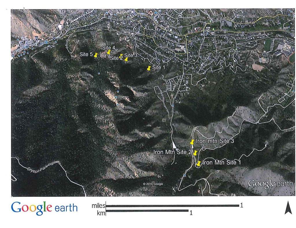
39 TRAILS


40 Inteman Trail site 1 Iron Mountain Site 3
A G E N D A Council Update Training Room September 26, :45 p.m.
 CITY OF THORNTON CITY MANAGER S OFFICE A G E N D A Council Update Training Room September 26, 2017 5:45 p.m. A. Boards and Committees Reports (Estimated 20 Minutes) 1. Rangeview Library District Meeting
Town of Lyons Parks Flood Recovery Planning Process. Photograph courtesy of Ed Bruder
 Town of Lyons Parks Flood Recovery Planning Process Photograph courtesy of Ed Bruder Lyons Parks and Recreation Flood Recovery Update 1. Meadow Park Phase II - Project PW20B1 Estimated Completion: Summer
SOUTH FOX MEADOW STORMWATER IMPROVEMENT PROJECT
 VILLAGE OF SCARSDALE WESTCHESTER COUNTY, NEW YORK COMPREHENSIVE STORM WATER MANAGEMENT SOUTH FOX MEADOW STORMWATER IMPROVEMENT PROJECT In association with WESTCHESTER COUNTY FLOOD MITIGATION PROGRAM Rob
NAI Principles In Gwinnett County
 NAI Principles In Gwinnett County By Cornelius Ani, LSIT, CFM Contributors: Adena Fullard, P.E., CPSWQ Rudresh Bihalli, P.E., CFM Ken Kagy, P.E., CPESC, CPSWQ Ligia Negru, M. Sc., CFM Maja Radovic, CPESC,
Stormwater Regulations & Considerations Morse Study Area. Pam Fortun, P.E. CFM Senior Stormwater Treatment Engineer Engineering Services Division
 Stormwater Regulations & Considerations Morse Study Area Pam Fortun, P.E. CFM Senior Stormwater Treatment Engineer Engineering Services Division Stormwater Regulations Development Considerations Floodplain
When planning stormwater management facilities, the following principles shall be applied where possible.
 2.0 Principles When planning stormwater management facilities, the following principles shall be applied where possible. 2.0.1 Drainage is a regional phenomenon that does not respect the boundaries between
San Diego River Coalition 2012 Work Plan
 San Diego River Coalition 2012 Work Plan Adopted November 18, 2011 The mission of the San Diego River Coalition is preserve and enhance the San Diego River, its watershed, and its natural, cultural and
Towards a Resilient Stormwater Future: Building Back from Hurricane Irene and Tropical Storm Lee. October 15, 2015 VUSP Symposium
 Towards a Resilient Stormwater Future: Building Back from Hurricane Irene and Tropical Storm Lee October 15, 2015 VUSP Symposium Russ Dudley, P.E., LEED AP Environmental Engineer Presentation Outline Impacts
CITY OF VALPARAISO STORMWATER MASTER PLAN
 CITY OF VALPARAISO STORMWATER MASTER PLAN APPROVED BY THE VALPARAISO CITY UTILITIES BOARD OCTOBER, 2016 Prepared by the City of Valparaiso Engineering Department PLAN SUMMARY Major flash flooding in August
Bay County RESTORE Act Direct Component Proposals The project will encompass all of Unincorporated Bay County as a whole.
 Proj # Bay PRP 2014-016 Project Name Bay County Master Plan and Capital Improvement Strategic Plan Update Project Proposer, affiliation, web site Project Description Proj. Size (acres) Economic Environmental
CHECKLIST FOR PHASE II DRAINAGE REPORT
 I. COVER SHEET CHECKLIST FOR PHASE II DRAINAGE REPORT A. Name of Project B. Address C. Owner D. Developer E. Engineer F. Submittal date and revision dates as applicable II. GENERAL LOCATION AND DESCRIPTION
6.5 Lakewood Gulch. Basin Snapshot
 6.5 Lakewood Gulch The Lakewood Gulch Map Unit is comprised of both Lakewood Gulch and Dry Gulch (4800-01 and 4801-01) from the Denver Storm Drainage Master Plan (SDMP) and has a total drainage area of
Durango Parks & Recreation Department. Strategic Plan
 Durango Parks & Recreation Department Strategic 2019-2023 Adopted April 2019 Overview The purpose of the adopted 2010 Parks, Open Space, Trails and Recreation Master is to provide a 10-year road map for
STORMWATER UTILITY FREQUENTLY ASKED QUESTIONS
 STORMWATER UTILITY FREQUENTLY ASKED QUESTIONS What is Stormwater? Stormwater is water that falls to the ground during a precipitation event. When land is undeveloped or covered with vegetative surface,
Chapter 5: Natural Resources and Environment
 NATURAL RESOURCES AND ENVIRONMENT 5-1 5 Chapter 5: Natural Resources and Environment BACKGROUND AND INTENT Urban expansion represents the greatest risk for the future degradation of existing natural areas,
Billing Code: DEPARTMENT OF HOUSING AND URBAN DEVELOPMENT [Docket No. FR-6072-N-01]
![Billing Code: DEPARTMENT OF HOUSING AND URBAN DEVELOPMENT [Docket No. FR-6072-N-01]](/thumbs/91/107309814.jpg "Billing Code: DEPARTMENT OF HOUSING AND URBAN DEVELOPMENT [Docket No. FR-6072-N-01]") This document is scheduled to be published in the Federal Register on 12/18/2017 and available online at https://federalregister.gov/d/2017-27194, and on FDsys.gov Billing Code: 4210-67 DEPARTMENT OF HOUSING
This document is scheduled to be published in the Federal Register on 12/18/2017 and available online at https://federalregister.gov/d/2017-27194, and on FDsys.gov Billing Code: 4210-67 DEPARTMENT OF HOUSING
Waukee. City of. The Key to Good Living
 Waukee City of The Key to Good Living City of Waukee FY15 - FY20 CIP Project Summary FY2015 FY2018 Parks Windfield Park Improvements Parks Centennial Park Amphitheater Parks Grant Park Improvements Parks
RESPONSES TO PUBLIC CONCERNS AND QUESTIONS
 RESPONSES TO PUBLIC CONCERNS AND QUESTIONS Stations and Summary Questions for Public Meeting #2 June 23, 2015 General Questions / Concerns: 1. Is there any way this development can raise revenue for the
Problem Understanding
 Introduction...2-1 Previous Data and Mapping...2-2 Known Problem Areas...2-3 Resident Survey.2-3 Introduction The Village of Downers Grove stormwater system includes storm sewers, streams, wetlands, roadway
Turkey Creek Streamway Corridor
 Turkey Creek Streamway Corridor Turkey Creek Corridor Overview History Watershed Corridor Inventory Coalition Corridor Plan Stages of Development Benefits Funding Turkey Creek History Kansas and Missouri
Stormwater Management at The University of New Orleans
 University of New Orleans ScholarWorks@UNO DRU Workshop 2013 Presentations Disaster Resistant University Workshop: Linking Mitigation and Resilience Conferences and Workshops 3-1-2013 Stormwater Management
Client #: Dawson /91. NRCS Tract #(s): Location: Fleming Memorial Park Field #(s): Program(s): Urban Project Name: Date:
: Location: Fleming Memorial Park Field #(s): Program(s): Urban Project Name: Date:") Natural Resource Stewardship Plan Jackson Soil and Water Conservation District 89 Alder Street Central Point, Oregon 97502 Ph. (541) 664-1070 www.jswcd.org Client Name: Elisa Dawson, City of Rogue River
Natural Resource Stewardship Plan Jackson Soil and Water Conservation District 89 Alder Street Central Point, Oregon 97502 Ph. (541) 664-1070 www.jswcd.org Client Name: Elisa Dawson, City of Rogue River
FY Capital Improvement Program Arroyo Projects
 FY 219-223 Capital Improvement Program FY 218 FY 219 FY 22 FY 221 FY 222 FY 223 1 2 3 4 5 6 7 8 9 1 Hahamongna - Implement Master Plan - Oak Grove Area Improvements (7756) Hahamongna - Implement Master
GENERAL INFORMATION What is Stormwater? What is a stormwater utility? What is an impervious surface?
 GENERAL INFORMATION What is Stormwater? Stormwater is rain or snowmelt that falls on streets, parking areas, rooftops, and other developed land and either flows directly into nearby streams or travels
Colorado Watershed Protection Fund - Project Grant Application Fountain Creek Restoration Shryver Park Reach Including Shryver Pond
 Fountain Creek - Manitou Springs, CO Shryver Park Reach and Pond Restoration Project Submitted by: The Fountain Creek Restoration Committee & The Pikes Peak Community Foundation April 28, 2008 FCRC Page
M-231 and Water Quality. Ottawa County Water Quality Forum November 21, 2016 James Fortney, MDOT
 M-231 and Water Quality Ottawa County Water Quality Forum November 21, 2016 James Fortney, MDOT M-231 Facts: 7-Miles long 2-Lane Limited Access Highway Connects I-96 and M-45 M-231 Facts: Includes Michigan
Getting the Locals to Go Along. Keys to Tulsa s Successful Floodplain Management
 Getting the Locals to Go Along Keys to Tulsa s Successful Floodplain Management Presented by: Ronald D. Flanagan, CFM Principal Planner Flanagan & Associates, LLC Land-Use & Natural Hazards Planning Consultants
ROAD PAVING VARIOUS LOCATIONS LANE KM
 ROAD PAVING VARIOUS LOCATIONS 9.317 LANE KM $1,465,200 General: $1,465,200 BASED ON CONDITION ASSESSMENTS OF THE ENTIRE ROAD NETWORK; USING ASSET MANAGEMENT PRINCIPLES, ROADS THAT ARE SUITABLE FOR REPAVING
TOWNSHIP OF HOWELL TOWNSHIP OF HOWELL ENGINEERING PROJECTS STATUS REPORT OCTOBER 19, Resurfacing of Aldrich Road West Contract # 11-06
 TOWNSHIP OF HOWELL DEPARTMENT OF COMMUNITY DEVELOPMENT & LAND USE DIVISION OF ENGINEERING 251 Preventorium Road Phone: (732) 938-4500 x2300 Post Office Box 580 Fax: (732) 919-1080 Howell, NJ 07731-0580
Citizen Information Meeting
 Prince William County Government Citizen Information Meeting Vint Hill Road Extension May 11, 2016 Benefits: Route 28 Corridor Improvement Program Estimated significant cost savings versus bidding these
East Montpelier SWMP Preliminary BMP Summary Sheet BMP ID #: 1 Site name: U-32 High School. Current site type
 East Montpelier SWMP Preliminary BMP Summary Sheet BMP ID #: 1 Site name: U-32 High School 930 Gallison Hill Rd, East Montpelier, VT Filter Berm, Sand Filter, Cistern / Rain Barrel, Gravel Wetland, Check
MEETING DATE: November 12, 2013 SUBJECT: Accept Borden Road Bridge Improvement (CIP No )
") AGENDA REPORT Meeting of the San Marcos City Council MEETING DATE: November 12, 2013 SUBJECT: Accept Borden Road Bridge Improvement (CIP No. 88165) Recommendation Staff recommends the City Council adopt
AGENDA REPORT Meeting of the San Marcos City Council MEETING DATE: November 12, 2013 SUBJECT: Accept Borden Road Bridge Improvement (CIP No. 88165) Recommendation Staff recommends the City Council adopt
Lower Meramec Multi-Jurisdictional Floodplain Management Plan Public Involvement (Results of Early Public Engagement) 27 June 2018
 27 June 2018") Lower Meramec Multi-Jurisdictional Floodplain Management Plan Public Involvement (Results of Early Public Engagement) 27 June 2018 Public Involvement Summary: The planning process includes opportunities
Lower Meramec Multi-Jurisdictional Floodplain Management Plan Public Involvement (Results of Early Public Engagement) 27 June 2018 Public Involvement Summary: The planning process includes opportunities
Update on the Bayfront Canal Bypass Project. Recommendation This an informational item only. No City Council action is required at this time.
 AGENDA ITEM H-7 continued from 4/18 Public Works STAFF REPORT City Council Meeting Date: 4/18/2017 Staff Report Number: 17-081-CC Informational Item: Update on the Bayfront Canal Bypass Project Recommendation
PLAN SUBMITTER'S CHECKLIST
 Page 1 of 8 PLAN SUBMITTER'S CHECKLIST FOR EROSION AND SEDIMENT CONTROL PLANS Please fill in all blanks and reference the plan sheets/pages where the information may be found, where appropriate, or write
Checklists. Project Name: Location: File Number: Date of Submittal: Reviewer: Date: Applicant: Contact Name: Phone Number:
 Applicant: Contact Name: Phone Number: Email: Project Name: Location: File Number: Date of Submittal: Reviewer: Date: Concept Plan Requirements: I. General Project Information 1. Address or parcel number
October 26, :00 pm
 October 26, 2016 6:00 pm 1 Increase knowledge of the Pinellas- Anclote (West) Watershed Work together to improve drainage systems in the watershed Involve residents in developing potential solutions Provide
HAZARD MITIGATION GOALS AND OBJECTIVES
 SEWRPC Community Assistance Planning Report No. 282, 2nd Edition CITY OF MILWAUKEE ALL HAZARDS MITIGATION PLAN UPDATE Chapter IV HAZARD MITIGATION GOALS AND OBJECTIVES [NOTE: Throughout this plan update
City of Meriden Harbor Brook Flood Control Project Overview
 City of Meriden Harbor Brook Flood Control Project Overview Updated August 2013 OVERVIEW The center of Meriden, including the HUB site is the low point of the town which is ringed by basalt ridges. Running
AGENDA 2015 Community Stormwater Event
 AGENDA 2015 Community Stormwater Event Sponsors: 2015 Community Stormwater Event AGENDA 2015 Community Stormwater Event Welcome 6:00 1 st prize drawing 6:15 Stormwater Video final destination Stormwater
GREEN STREETS & INFRASTRUCTURE: A COUNTY APPROACH. Mimicking Nature to Manage Stormwater in Developed Areas
 GREEN STREETS & INFRASTRUCTURE: A COUNTY APPROACH Mimicking Nature to Manage Stormwater in Developed Areas Jennifer Gonzalez, Environmental Planner Passaic County Depar tment of Planning & Economic Development
ARROYO PROJECTS ADOPTED CAPITAL IMPROVEMENT PROGRAM BUDGET
 A RROYO P ROJECTS ADOPTED CAPITAL IMPROVEMENT PROGRAM BUDGET FISCAL YEARS 214-218 HAHAMONGNA Priority Description 1 Hahamongna Watershed Park - Implement Master Plan 211,6 211,6 (77565) 2 Hahamongna -
SECTION 5: REACH RECOMMENDATIONS/MAPS
 SECTION 5: REACH RECOMMENDATIONS/MAPS This section describes areas of concern and provides specific recommendations for each project reach. Locations of stormwater drains were from GIS coverage supplied
City of Sun Prairie Wetland Buffer Reduction Request
 City of Sun Prairie Wetland Buffer Reduction Request Westside Development Area January 9, 2017 Prepared by: City of Sun Prairie 300 E. Main Street Sun Prairie, WI 53590 BACKGROUND The City of Sun Prairie
ADOPTED CAPITAL IMPROVEMENT PROGRAM BUDGET ARROYO PROJECTS
 ADOPTED CAPITAL IMPROVEMENT PROGRAM BUDGET ARROYO PROJECTS HAHAMONGNA FY 212-216 Capital Improvement Program Priority Description Total Estimated Costs Appropriated Through FY 211 Adopted FY 212 FY 213
LOUISIANA STATE UNIVERSITY COMPREHENSIVE & STRATEGIC CAMPUS MASTER PLAN. APPENDIX G - Stormwater Study Findings & Stormwater Solutions
 LOUISIANA STATE UNIVERSITY COMPREHENSIVE & STRATEGIC CAMPUS MASTER PLAN APPENDIX G - Stormwater Study Findings & Stormwater Solutions LSU: MP Narrative July 2017 3.5 Open Space Existing Conditions The
Public Meeting May 20, 2014
 Public Meeting May 20, 2014 Overview Study Purpose Study Area Overview Strategies Potential Opportunities Implementation and Discussion Skeo Solutions Raleigh Walkable Watershed Pilot 2 Purpose Develop
The following principles guide the development of goals and strategies to protect and promote these amenities:
 OPEN SPACE/PARKS/TRAILS/RECREATION GOALS/STRATEGIES Cherry Hills Village is a living environment that offers low density development, open areas, public scenic vistas, public trails and public parks. This
Project Narrative For Fruita RV Resort Conditional Use Permit
 Project Narrative For Fruita RV Resort Conditional Use Permit Date: November 18, 2016 Prepared by: Robert W. Jones, II, P.E. Vortex Engineering & Architecture, Inc. 2394 Patterson Rd., Ste. 201 Grand Junction,
City of Waco Stormwater Management Regulations
 1.0 Applicability: City of Waco Stormwater Management Regulations These regulations apply to all development within the limits of the City of Waco as well as to any subdivisions within the extra territorial
Section 11 Grading and Drainage Standards
 Section 11 Grading and Drainage Standards 11.1 INTRODUCTION The proper grading, conveyance, storage and release of storm water is critical to maintain the integrity of the Property. Drainage facilities,
Northern Branch Corridor DEIS December 2011
 16 Floodplains 161 Chapter Overview 1611 Introduction The flowing chapter identifies floodplains found within the Northern Branch Corridor in accordance with Executive Order 11988, Floodplain Management
CITYWIDE DRAINAGE ASSESSMENT REPORT
 CITYWIDE DRAINAGE ASSESSMENT REPORT Department of Community Services Engineering Division November 2012 Page 1 of 34 Table of Contents Introduction 3 Summary 4 CATEGORY I DRAINAGE LOCATIONS 1. Waldron
Urban Stormwater Retrofit Program Highlights
 Urban Stormwater Retrofit Program Highlights Delaware Estuary Environmental Summit 2007 Prepared and Presented by: Liz Feinberg Project Funding: William Penn Foundation PA Coastal Zone Management Program
STORMWATER MANAGEMENT CODES ANALYSIS RICHLAND COUNTY, SC SITE PLANNING ROUNDTABLE
 STORMWATER MANAGEMENT CODES ANALYSIS RICHLAND COUNTY, SC SITE PLANNING ROUNDTABLE Codes analyses for each subcommittee were completed to assist participants of the Richland County Site Planning Roundtable.
City of East Point Comprehensive Floodplain Management Program
 City of East Point Comprehensive Floodplain Management GAFM 2012, 7 th Annual Technical Conference Reza Aral, CFM, CPESC (City of East Point, GA) Shayne Wood, P.E. (CDM Smith) March, 28, 2012 Agenda Overview
Urban Water Management (ESRM 311 & SEFS 507) Cougar Mtn Regional Wildland Park & Lakemont Blvd, Bellevue WA
 Cougar Mtn Regional Wildland Park & Lakemont Blvd, Bellevue WA") Urban Water Management (ESRM 311 & SEFS 507) Cougar Mtn Regional Wildland Park & Lakemont Blvd, Bellevue WA Lecture Today Urban Water management terms Examples of water management in urban areas Field
Urban Water Management (ESRM 311 & SEFS 507) Cougar Mtn Regional Wildland Park & Lakemont Blvd, Bellevue WA Lecture Today Urban Water management terms Examples of water management in urban areas Field
Floodplain Technical Memorandum
 Southeast Extension Project Lincoln Station to RidgeGate Parkway Prepared for: Federal Transit Administration Prepared by: Denver Regional Transportation District May 2014 Table of Contents Page No. Chapter
Level 1 Downstream Analysis
 Level 1 Downstream Analysis Newcastle Way Apartments Newcastle, Washington King County April 14, 2014 Revised July 10, 2014 Prepared by: Dean A. Furr, P.E. Reviewed by: Donald Scarberry, P.E. Coffman Engineering,
Urban runoff in my neighborhood (Capitol Hill) is heavy with trash and other debris.
 is heavy with trash and other debris.") South Platte River Meeting Comments & s #1 I am a huge fan of river areas and would love the Platte and surrounding waterways to improve to allow habitat for wildlife and recreation opportunities for citizens.
South Platte River Meeting Comments & s #1 I am a huge fan of river areas and would love the Platte and surrounding waterways to improve to allow habitat for wildlife and recreation opportunities for citizens.
Planning for Staten. Habitat Restoration and Green Infrastructure. Island s North Shore
 Habitat Restoration and Green Infrastructure Planning for Staten Island s North Shore Community Board 1 March 1, 2018 NYC Parks Forestry, Horticulture, and Natural Resources Funded by the NYS Department
Kittson Parkway / Watershed Park Parking Lot
 Kittson Parkway / Watershed Park Parking Lot Date Constructed: Summer 2005 Site Location / Description: Kittson Parkway, North Delta, British Columbia. Permeable parking lot adjacent to Watershed Park;
Potential Green Infrastructure Strategies May 6, 2015 Workshop
 Potential Green Infrastructure Strategies May 6, 2015 Workshop Background The City of Cortland is developing the Tioughnioga Urban Headwaters Green Infrastructure Action Plan with funding from the National
Poisoned Park? How Exide s Lead Contamination Risks Frisco s Grand Park
 Frisco City Hall has big plans to transform Stewart Creek into a Grand Park with lots of water features for kids to play in. Poisoned Park? How Exide s Lead Contamination Risks Frisco s Grand Park But
THREE-YEAR CAPITAL IMPROVEMENT PLAN FY
 THREE-YEAR CAPITAL IMPROVEMENT PLAN FY2016 2018 Annual CIP Development Process Public Works & Engineering Divisions Prepare List of Capital Needs and Recommended Deferred Maintenance Public Works & Engineering
Pasco County Watershed Meeting for Flood Impacted Areas Port Richey Watershed
 Pasco County Watershed Meeting for Flood Impacted Areas March 15, 2017 Regency Park Library, 9701 Little Road, New Port Richey, Pasco County The following is a summary of the meeting held on March 15,
Enhance the High Line Canal Projects
 Enhance the High Line Canal Projects Joint Project Proposal for Arapahoe County Open Spaces Funding Partner Sponsors: South Suburban Park and Recreation District City of Centennial City of Littleton October
Example Stormwater Control Plan For a Residential Subdivision Project. Whispering Pines Lane Anytown, USA. February 21, 2018
 Example Stormwater Control Plan For a Residential Subdivision Project Whispering Pines Lane Anytown, USA February 21, 2018 XYZ Corporation Jane Jones, 925-555-1212 This example prepared by Dan Cloak Environmental
Sustainable Storm Water Management
 Incorporating Water Management into the Community Planning Process August 16, 2012 Sustainable Storm Water Management Samantha Brown Environmental Engineer SD1 SD1 s Service Area CVG Airport SD1 Service
Prado Ranch North Common Open Space Tentative Map. Washoe County Planning Commission July 3, 2018
 Prado Ranch North Common Open Space Tentative Map Washoe County Planning Commission July 3, 2018 Site Characteristics Intersection of Chickadee and Lemmon Drive ~1 mile north of Deodar/Lemmon Drive intersection
The Benefits and Challenges Associated with Green Infrastructure Practices
 The Benefits and Challenges Associated with Green Infrastructure Practices Thomas M. Evans ASLA, LEED AP Regional Green Infrastructure Design Services Director OWEA Technical Conference, June 20, 2013
Priorities. Public Communication & Transparency Website, CM Public Updates, Magic City Newsletter
 Priorities Recognition & Thanks to public servant employees Public Communication & Transparency Website, CM Public Updates, Magic City Newsletter Citizen/Customer Service Fiscal Responsibility Flood Protection
5-Year Street Reconstruction Plan ( )
") 5-Year Street Reconstruction Plan (2006-2010) City of Delano Wenck File #0564-37 Prepared for: CITY OF DELANO 234 2 nd Street West Delano, MN 55328 Prepared by: WENCK ASSOCIATES, INC. 1800 Pioneer Creek
5-Year Street Reconstruction Plan (2006-2010) City of Delano Wenck File #0564-37 Prepared for: CITY OF DELANO 234 2 nd Street West Delano, MN 55328 Prepared by: WENCK ASSOCIATES, INC. 1800 Pioneer Creek
3. VISION AND GOALS. Vision Statement. Goals, Objectives and Policies
 Vision Statement Queen Creek s interconnected network of parks, trails, open spaces and recreation opportunities provide safe and diverse activities and programs that sustain its unique, small town, equestrian
FY STATEWIDE TRANSPORTATION IMPROVEMENT PROGRAM New Jersey Department of Transportation Projects
 ROUTE/ Project ID No. TIP No. Burlington County Computerized Signal Control, IV D9911 D9911 This ITS project will be a traffic responsive signal system, consisting of 24 intersections--9 on CR 607, 4 on
Neighborhood One. Location. Existing Land Use
 Neighborhood One Location Neighborhood One is bounded by Route 29 North on the east, Hydraulic Road on the south, (and a small area to the south of Hydraulic Road), the South Fork Rivanna River reservoir
WASHINGTON COUNTY OREGON
 WASHINGTON COUNTY OREGON LONG RANGE PLANNING DIVISION North Bethany Subarea Stream Corridors: Existing Regulations In Oregon, there is a distinct difference between the land use rules that apply in rural
MASTER DEVELOPMENT DRAINAGE PLAN FOR MONUMENT HEIGHTS
 MASTER DEVELOPMENT DRAINAGE PLAN FOR MONUMENT HEIGHTS DRAINAGE REPORT STATEMENT ENGINEER'S STATEMENT: The attached drainage plan and report were prepared under my direction and supervision and are correct
Moon Brook FRP BMP Summary Sheet. Ownership of Land where BMP is Located
 Outlet Retrofit Hitzel Terrace The town owned parcel along Hitzel Terrace is a natural wetland area which currently provides some level of stormwater detention and peak-flow attenuation. The proposed project
Yadkin River Greenway Feasibility Study Fact Sheet Village of Clemmons, Town of Lewisville, Town of Bermuda Run
 Fact Sheet Village of Clemmons, Town of Lewisville, Town of Bermuda Run Project Background The Yadkin River Greenway Feasibility Study is a joint project with the Village of Clemmons, the Town of Bermuda
VALUE OF URBAN DRAINAGE PLANNING AND FLOOD HAZARD REDUCTION PROJECTS IN THE 2013 FLOOD
 VALUE OF URBAN DRAINAGE PLANNING AND FLOOD HAZARD REDUCTION PROJECTS IN THE 2013 FLOOD ANDREW EARLES, PH.D., P.E. WRIGHT WATER ENGINEERS, INC. & KEN MACKENZIE, P.E., CFM UDFCD October 11, 2013 Water Resources
RFP DRAINAGE OUTFALL DESIGN AND PERMITTING. Mandatory Meeting for Proposers August 15, 2015
 RFP 2018-02 DRAINAGE OUTFALL DESIGN AND PERMITTING Mandatory Meeting for Proposers August 15, 2015 IMPORTANT DATES August 15 th, 2:00pm August 17 th, 5:00pm August 22 nd, 5:00pm September 5 th, 2:00pm
Town of Yucca Valley Capital Improvement Projects Report July 24, 2014
 Town of Yucca Valley Capital Improvement Projects Report July 24, 2014 SR 62 Traffic and Pedestrian Improvements from Apache Trail to Palm Avenue (PLHD) The project includes construction of curbs, gutters,
River Corridor Overlay Zone (RCOZ) Article 5
 Article 5") River Corridor Overlay Zone (RCOZ) Article 5 The site is in one of two designated districts. The first is the CBD (central business district) River District, which recognizes the urban character and unique
River Corridor Overlay Zone (RCOZ) Article 5 The site is in one of two designated districts. The first is the CBD (central business district) River District, which recognizes the urban character and unique
Flooding Hearing: Long and Short Term Strategies
 Services of the San Francisco Public Utilities Commission Flooding Hearing: Long and Short Term Strategies Presentation to San Francisco Board of Supervisors Public Safety and Neighborhood Services Subcommittee
Stormwater Outfall Inventory and Mapping City and Borough of Juneau
 Stormwater Outfall Inventory and Mapping City and Borough of Juneau Date of field work: 5/08-9/08 Purpose of Project: The intent of the project was to inventory and assess existing outfalls along impaired
Project Descriptions for FY 15
 Department of Transportation and Stormwater Services Stormwater Engineering and Design Division Project Descriptions for FY 15 43 rd Street Outfall PH II Pond Regional Drainage Improvement Flooding Relief
Jill Stachura STORMWATER BMP AND STREAM RESTORATION IN A CITY PARK. October 2013 Southeast Stormwater Association Annual Conference, Charlotte, NC
 Jill Stachura STORMWATER BMP AND STREAM RESTORATION IN A CITY PARK October 2013 Southeast Stormwater Association Annual Conference, Charlotte, NC Project Location Gwinnett County, GA: Population: 825,000
Chapter 3 Site Planning and Low Impact Development
 CHAPTER 3 Site Planning and Low Impact Development Chapter 3 Site Planning and Low Impact Development 3.0 Introduction The City of Charleston requires that major residential, large commercial (>1 acre),
Anne Arundel County s Severn River Watershed Implementation Strategy. Severn River Association
 Anne Arundel County s Severn River Watershed Implementation Strategy Severn River Association Watershed Protection and Restoration Program Anne Arundel County Department of Public Works August 18, 2014
WQ-23 MOUNTAINOUS AND STEEP SLOPE SITES
 Greenville County Technical Specification for: WQ-23 MOUNTAINOUS AND STEEP SLOPE SITES 1.0 Mountainous and Steep Slope Sites 1.1 Description The geographic locations of portions of Greenville County are
Town of Corinth Road Erosion Inventory Report
 Town of Corinth Road Erosion Inventory Report Grist Mill Road. Photo taken by TRORC staff. Prepared by: 128 King Farm Road Woodstock, VT 05091 Inventory and report funded by the Vermont Agency of Transportation
12/7/2007. Christopher B. Burke Engineering West, Ltd Aux Sable Creek Watershed Plan Update 1
 The ABC s of BMP s Aux Sable Watershed Plan St. Charles, IL Why are BMP s Important Best Management Practices (BMPs) developed as a set of practices which help to achieve goals of the Clean Water Act and
MANUAL OF DESIGN, INSTALLATION, AND MAINTENANCE REQUIREMENTS FOR STORMWATER MANAGEMENT PLANS
 MANUAL OF DESIGN, INSTALLATION, AND MAINTENANCE REQUIREMENTS FOR STORMWATER MANAGEMENT PLANS May 2007 SECTION 1 Responsibility of Applicant TABLE OF CONTENTS A. Stormwater Management Plan Required Information
Downtown Denver Morrison. Located 30 minutes from downtown Denver behind the hogback
 Downtown Denver Morrison Located 30 minutes from downtown Denver behind the hogback Founded in 1874 as a passageway gold mines to the west. Morrison is the gateway to the Bear Creek Canyon. Surrounded
Lilburn, GA STORMWATER BMP AND STREAM RESTORATION IN A CITY PARK. July 2013 Jill Stachura
 Lilburn, GA STORMWATER BMP AND STREAM RESTORATION IN A CITY PARK July 2013 Jill Stachura Project Location Gwinnett County, GA: Population: 825,000 Area: 437 sq. miles 1,300 miles storm drainage system
City of Lafayette Study Session Staff Report Design Review Commission
 ++ City of Lafayette Study Session Staff Report Design Review Commission Meeting Date: January 08, 2018 Staff: Subject: Chris Juram, Planning Technician SS12-17 Miramar Homebuilders, R-20 Zoning: Request
A District Council of the Urban Land Institute
 A District Council of the Urban Land Institute A District Council of the Urban Land Institute Thank you to our sponsors! Corporate Sponsors: Supporter Sponsors: Friend Sponsor: Thank you to our Community
Town of Vershire Road Erosion Inventory Report
 Town of Vershire Road Erosion Inventory Report Taylor Valley Road. Photo taken by TRORC staff. Prepared by: 128 King Farm Road Woodstock, VT 05091 Inventory and report funded by the Vermont Agency of Transportation
Natural Resource Protection
 VISION Our Parker community will enhance the quality of life by avoiding development in environmentally hazardous areas and by safeguarding the natural environment. Natural Resource Protection Introduction