Whirlwind Beach Neighborhood Meeting No.2
|
|
|
- Scarlett Copeland
- 5 years ago
- Views:
Transcription

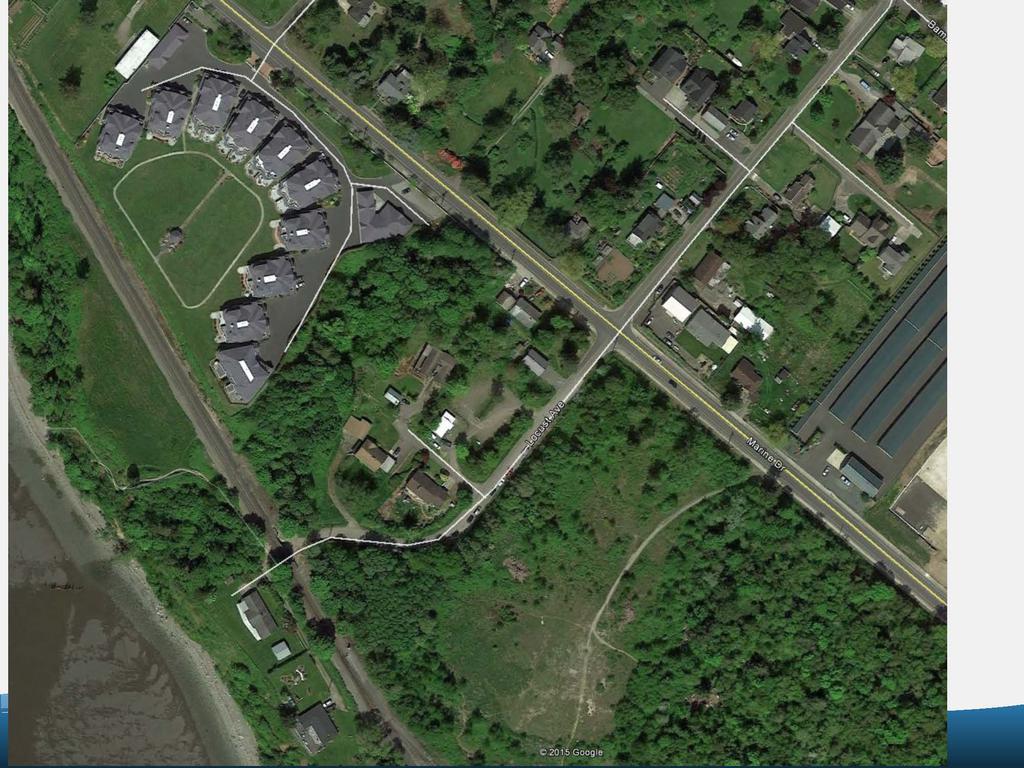
1 Whirlwind Beach Neighborhood Meeting No.2 August 20, 2015 Gina Gobo Austin, Project Engineer City of Bellingham Parks and Recreation Design and Development Division 1

2 Topics for Tonight Current status Preliminary design Schedule Next steps Park naming Open discussion 2

3 Project Status Cultural Resources Critical Areas Asbestos Permits 3

4 Preliminary Design Overview Parking Landscaping Trash/dumpster Pet waste station Interpretive Sign Park Sign Bicycle parking Motorcycle parking Security Lighting Restroom 4


5 Trailhead Design $225,000 (approx.) Looking for more funding Design this year Construct next year Site amenities: Paved parking Restroom Trash receptacles Signs Security lighting Way finding Sign Trailhead Sign Restroom Building Park Sign Trash Receptacle 5
6 6

7 cot.doml ~ IUMS IOCO,... u,.. NY.!ill'l 10L1 t1o.,.i, K10t.1t.._V.M QD'I' / I ;;_- / / APN ; ; IOCO RM Ttt.11 tw. ""1c1.1 t<n

8 :s... Wo/NC 08-' WVO< T "" N./NW 7:r."... APN a RUltO "' T 5' \\10E L ~rl DSC APE AREA 5' 'MDC LAN05CAP( >ICA '.~ /. 1. -=- /I:- -f 'f <::: - ~.:::::::1 - \,_- - 0 ERMlf REOJIRED' SIGN PROPOSED,-===if,. '"""STAT DISABLED- PARl<INC SER\'ICE CONNE.:::::::I } - PERMIT REOUIRED, VAN ~ COUN IY S AJ\IJAIO U~!AIL :-.cces.9ble9 sret. ~ RIG rr or -vv sos o "NO PARKING" SIGN :::::::1 ~_~~s----:::-s~~~s~~~ s~~~s~~~s ==-~~ s~~~s~~~s~~~s~s~,...~jr'"-~ ~ ~~-...,,... ~ --- FROPOS 0 GRAVITY- > FRCPOSEO 8" CRA\'ITY 5E\\ R UNHOLE ~E\\ER 8

9 Restroom Building Detention Pond Dumpster Park Bench Wood Privacy Fence Maintenance Access Landscape Screening Street Trees Interpretive Sign Bike Racks Fence along south side Park Sign 9


10 Next steps Public meeting Design Permits Bid - Spring 2016 Construct - Summer 2016 Continue coordination with County staff & neighborhood 10
11 Park Name Locust Whirlwind Others? 11
12 Open discussion/group Comments: Highest priority items: install gates, install trash cans, install park rules sign Consider pervious pavement in the design (used this design at Pack-A-Nut down the street) Post signs to keep people out of the new detention pond Add security lighting There is no street lighting. It s too dark in this area. Neher property is very dark at night There is no street light at the Marine Drive/Locust intersection. Install light so that street sign and intersection are visible. Consider moving pedestrian crossing closer to parking lot driveway entrance and away from private drive. It could be dangerous to turn onto Locust and see people crossing Include visual, planted boundary along private drive 12
13 Open discussion/group Comments: Why not relocate restroom to Marine drive Restroom should be in first phase of work very important Will improvements make sheriff situation better? What happens if city does not purchase beach area? Install garbage cans now How do we deal with people locking themselves in bathrooms, doing drugs, illegal activities in bathroom? There s only one trail access to beach. How will it be made more accessible/ada? Install a play structure on site. Consider more family-oriented activities at the parking lot. Eyes on the parking lot. There s no where for kids to play Keep pedestrian and vehicle access separate What is county s long range plans for the area? Street improvements? Other improvements? 13
14 Open discussion/group Comments: Don t want people walking down middle of the street. Need separate trail along the road. Need street light at Locust. Help identify this area as a public space LED lights could dim, then lighten up with motion sensor Can t see street sign at night. Need rinse-off shower, outside cold shower at restroom Consider relocating kite boarders to Neher shop. Encourage positive culture Kite boarder association is a membership organization. Use beach area when it s windy, about 250 days a year. Most ever kite boarders at beach is around at a time is more typical Is it self-serving for kite boarders to move to brand new shop on site? NSKB is a non-profit membership group. Members get code access to building. Show alternate location for restroom buildings. One location could be closer to driveway entrance. Another could be at Marine Drive. 14
15 Open discussion/group Comments: Prefer greenery over fence Kite boarders should be included and integrated in the design, not excluded. Eliminate their driveway and make them a part of the parking lot design Install a play structure & green space for neighborhood use. Make kid-friendly area at parking lot Create hedge along private drive Include kite boarder on site. They are good user group. Wouldn t want to see kite boarders front and center. Keep them in current location, but integrate them into the parking lot design. Be inclusive. Remove hedge between kite boarders and parking lot. Park name: whirlwind is a funny/different name. It s always been Locust beach and nothing else. It should be called Locust beach. What are the park hours? Should be dawn to dusk, not 6am to 10pm. Dusk is typically defined as 1 hour after sunset. 15
 778 7000")
16 Whirlwind Beach Neighborhood Meeting Presented by: Gina Gobo Austin, PE Project Engineer, Parks and Recreation Design and Development Division (360)
Park Types and Attributes
 02 APPENDIX B APPENDIX B s and s 194 APPENDIX B 04 Size Level of Service Any privately owned park, of any size, is a neighborhood park Primary Service Area - 1/2 mile or within 15 minutes walking distance
Item PZ South Lindbergh Project Overview
 Item PZ-042517-01 2001 South Lindbergh Project Overview Project consists of a redevelopment of 2001 South Lindbergh Boulevard, the former Shriner s Hospital site. The site contains 14.871 Acres. The proposed
Long Branch-Wayne Local Park Renovation Project
 Montgomery Parks Long Branch-Wayne Local Park Renovation Project Community Meeting #2 September 20, 2016 Oak View Elementary School 7:00-9:00 PM Welcome / Team Introductions M-NCPPC (Montgomery Parks)
Urban Design and Livability
 Urban Design and Livability City of Sacramento Planning Academy April 6, 2015 Bruce Monighan AIA Urban Design Manager, City of Sacramento How do we define cities in their characteristics of livability?
Devil s Slide Coastal Trail Improvements Project. County of San Mateo
 County of San Mateo Project History Measure T Nov.1996 Plans and Permits Task Force meetings Hired a team Board support Budget Project Overview Programming and Linkages Park hours Multi use trail Pedestrians
Welcome to the Public Meeting!
 Welcome to the Public Meeting! Please sign in, grab a paper survey, and check out the boards around the perimeter of the room. Once you ve viewed all of the boards, come join us in the middle of the room
Design for Health Comprehensive Plan Review Checklists. Design for Health,
 Comprehensive Plan Review Checklists, 2007 info@designforhealth.net These Comprehensive Plan Review Checklists summarize the key points of the (DFH) background and health impact assessment (HIA) materials.
BAY DRIVE PARK Questions and Answers
 Q. How tall is the building near the beach and what will it look like? A. The Park Amenity Building is a two-story metal-roofed coquina-faced building with a restroom on the first floor and an observation
The Vision. Photo provided by The Minervini Group. 46 Vision, Objectives & Strategies
 Vision, Objectives & Strategies The is the public framework and guide for future development of the Grand Traverse Commons. The establishes public polices for infrastructure, the preservation of natural
Charles P. Johnson and Associates. Annapolis Landscape Architects
 Charles P. Johnson and Associates Annapolis Landscape Architects AGENDA Introduction Project Limits and Scope Site Analysis Opportunities & Constraints Program Goals Image Boards Design Alternatives Pros
The open space system should provide connective elements, relate to natural resources, and enhance the suburban character of the landscape..
 The open space system should provide connective elements, relate to natural resources, and enhance the suburban character of the landscape.. Mixed-use and infill development should maintain or enhance
City of Plattsburgh DRI: Downtown Streetscapes & Riverfront Access. Downtown Streetscape and Riverfront Access Design
 City of Plattsburgh DRI: Downtown Streetscapes & Riverfront Access Welcome Thank you for coming this evening. Agenda PART I - Project Context The Downtown Revitalization Program Our DRI Projects Other
Design Alternatives Workshop. Hilfiker Park Master Plan Workshop #2
 Design Alternatives Workshop Hilfiker Park Master Plan Workshop #2 Agenda for Tonight Staff Presentation (40 min) Introduction Master Plan Process Planning Context What We ve Heard So Far Design Alternatives
Marshview Park. Concept Briefing and Feedback Session. Aquarium/Owls Creek Plan Steering Committee March 20, 2012
 Marshview Park Concept Briefing and Feedback Session Aquarium/Owls Creek Plan Steering Committee March 20, 2012 1 Outline of Today s Discussion Introductions Context for Marshview Park Site analysis -
DOWNTOWN VISIONING FORUM AGENDA JUNE 5, 2014
 DOWNTOWN VISIONING FORUM AGENDA JUNE 5, 2014 Welcome and Introductions Evolution of the Downtown Proposed Downtown Plan Overview and Process Have Your Say! Next Steps Closing Comments 1 WELCOME & INTRODUCTIONS
Application Number: SD Project Name: Walton Farms Preliminary Subdivision (acting as Master Plan)
") STAFF REPORT Town of Clayton Planning Department 111 E. Second Street, Clayton, NC 27520 P.O. Box 879, Clayton, NC 27528 Phone: 919-553-5002 Fax: 919-553-1720 Planning Board May 22, 2017 Application Number:
STAFF REPORT Town of Clayton Planning Department 111 E. Second Street, Clayton, NC 27520 P.O. Box 879, Clayton, NC 27528 Phone: 919-553-5002 Fax: 919-553-1720 Planning Board May 22, 2017 Application Number:
lot flankage Y street 16m 6m landscape strip for large site 3m landscape strip for small medium site
 Commercial General Commercial Objectives Create developments compatible with adjacent land uses in scale, function and character Define a consistent and attractive street edge with quality landscaping,
Planned Development Review Revisions (Project No. PLNPCM )
") Planned Development Review Revisions (Project No. PLNPCM2014-00139) Standard residential development Planned Development Example: Smaller lot sizes than what is allowed to create open space amenity. What
Planned Development Review Revisions (Project No. PLNPCM2014-00139) Standard residential development Planned Development Example: Smaller lot sizes than what is allowed to create open space amenity. What
Public Workshop #2 Summary
 Public Workshop #2 Summary Project Number: Project Title: 2320.01 (R&M) MOA Parks and Recreation Muldoon Town Square Park Master Plan Subject: Muldoon Town Square Park Master Plan Public Workshop #2 Author:
GREENING THE BOULEVARD Master Plan Concepts for Venice Boulevard between Lincoln and Sawtelle
 GREENING THE BOULEVARD Katherine Spitz Associates Inc. 4212½ Glencoe Avenue Marina Del Rey, CA 90292 310 574 4460 Fax 574 4462 January 2008 Table of Contents Overview Proposed Design Improvements Illustration
KEY MAP DEVELOPMENT PERMIT AREA MAP. Sunnymede North Sub-Area Plan
 Richmond Official Community Plan BROADMOOR AREA SUNNYMEDE NORTH SUB-AREA PLAN Bylaw 7100 Schedule 2.6C SUNNYMEDE NORTH SUB-AREA PLAN SUNNYMEDE NORTH SUB-AREA PLAN SUNNYMEDE NORTH SUB-AREA PLAN KEY MAP
The Illinois Department of Transportation and Lake County Division of Transportation. Route 173, including the Millburn Bypass
 The Illinois Department of Transportation and Lake County Division of Transportation welcome you to this Public Hearing for U.S. Route 45 from Illinois Route 132 to Illinois Route 173, including the Millburn
Subregion 4 Central Avenue-Metro Blue Line Corridor Transit-Oriented Development (TOD) Implementation Project. Community Meeting April 27, 2011
 Implementation Project. Community Meeting April 27, 2011") Subregion 4 Central Avenue-Metro Blue Line Corridor Transit-Oriented Development (TOD) Implementation Project Community Meeting April 27, 2011 Overview Introduction to Subregion 4 TOD Implementation Program
Subregion 4 Central Avenue-Metro Blue Line Corridor Transit-Oriented Development (TOD) Implementation Project Community Meeting April 27, 2011 Overview Introduction to Subregion 4 TOD Implementation Program
CHAPTER 8. Mrs. Zimman s Class - Central Elementary
 SUSTAINABILITY CHAPTER 8 Mrs. Zimman s Class - Central Elementary 8.1 OVERVIEW Green infrastructure also known as low impact development (LID) and environmental or sustainable site design is an environmentally
Bachman Creek Greenbelt Park
 1 Bachman Creek Greenbelt Park A Portion of Bachman Needs Renovation The Bachman Creek Greenbelt is a 54 acre park in the City of Dallas (the Park or the Greenbelt ). Most of the Greenbelt is contiguous
The Van Ness Campus. Weekly Construction Bulletin #259
 The Van Ness Campus Weekly Construction Bulletin #259 Construction Update Week of September 24, 2018 The Van Ness Campus Weekly Bulletins are intended to help inform members of the community about upcoming
Landscape and Streetscape Design 2.5
 Landscape and Streetscape Design 2.5 2.5.1 Goals 2.5.2 Planting 2.5.3 Sidewalks and Pavement 2.5.4 Furnishings 2.5.5 Walls 2.5.6 Lighting 2.5.7 Stormwater 2.5.8 Street Cross Sections 2.5 LANDSCAPE AND
Benedict Fountain Park Meeting Notes Wednesday, February 15, 2012
 Benedict Fountain Park Meeting Notes Wednesday, February 15, 2012 ALTERNATIVE #1 Like the big open lawn space in alternative 1. Like cohesiveness of sidewalk walk and play areas shown on alternative 1
RESIDENTIAL DESIGN STANDARDS AND GUIDELINES
 DRAFT RESIDENTIAL DESIGN STANDARDS AND GUIDELINES Resident ial Standards and Guidelines For the Unincorporated Communities of West Alameda County TASK FORCE MEETING March 22, 2010 Tonight s Meeting Overview
Canal Winchester Parks Master Plan. Public Meeting 2 Thursday, February 2 6:30pm
 Canal Winchester Parks Master Plan Public Meeting 2 Thursday, February 2 6:30pm Meeting Agenda 1. Project overview 2. Project schedule 3. Public input results Survey Public Meeting #1 Stakeholder Interviews
PLANNING AND NATURAL RESOURCES COMMITTEE. Public Access Conceptual Design Alternatives for the Red Barn Area of La Honda Creek Open Space Preserve
 PLANNING AND NATURAL RESOURCES COMMITTEE R-17-56 May 9, 2017 AGENDA ITEM AGENDA ITEM 2 Public Access Conceptual Design Alternatives for the Red Barn Area of La Honda Creek Open Space Preserve GENERAL MANAGER
City of Langford Green Development Checklist
 City of Langford Green Development Checklist The following Green Development Checklist creates a sustainability standard for all comprehensive development within the City of Langford. The commitments made
CITY OF SIMI VALLEY MEMORANDUM
 CITY OF SIMI VALLEY MEMORANDUM AGENDA ITEM NO. Consent (3) August 15, 2016 TO: FROM: City Council Department of Public Works SUBJECT: ADOPTION OF PLANS AND SPECIFICATIONS AND AUTHORIZATION TO SOLICIT CONSTRUCTION
WARM SPRINGS PARK MASTER PLAN
 TABLE OF CONTENTS page 1.0 Introduction and Overview 1 2.0 Information Gathering 2 3.0 Conceptual Alternative Development 8 4.0 Master Plan Development 14 5.0 Construction Cost Estimates 19 LIST OF FIGURES
Tonight s Agenda. Disbrow Park & Facilities Master Plan
 Disbrow Park & Facilities Master Plan Public Outreach Forum City of Rye, NY May 11, 2017 Tonight s Agenda. Break (10 min) Introduction: What s in the works? Stantec Presentation - Goals and objectives
Draft Memorandum #1: Goals and Vision for Revitalization
 Keizer Revitalization Plan Draft Memorandum #1: Goals and Vision for Revitalization Submitted to: City of Keizer April 12, 2018 (revised) Prepared By: Angelo Planning Group and Otak, Inc. Project No. 17482.A
LOCATION AND DESIGN DIVISION
 VIRGINIA DEPARTMENT OF TRANSPORTATION LOCATION AND DESIGN DIVISION INSTRUCTIONAL AND INFORMATIONAL MEMORANDUM GENERAL SUBJECT: Landscape Architecture Program NUMBER: SPECIFIC SUBJECT: Integration of Landscape
3. VISION AND GOALS. Vision Statement. Goals, Objectives and Policies
 Vision Statement Queen Creek s interconnected network of parks, trails, open spaces and recreation opportunities provide safe and diverse activities and programs that sustain its unique, small town, equestrian
South th E ast Communit ity Centre (SECC)
") South East Community Centre (SECC) 1 New Park Design & Community Centre Update Thursday, February 8, 2018 Public Open House Thank you for attending this Open House! The town and the Consulting Team will
South East Community Centre (SECC) 1 New Park Design & Community Centre Update Thursday, February 8, 2018 Public Open House Thank you for attending this Open House! The town and the Consulting Team will
URBAN DESIGN BRIEF 181 Burloak Drive, Oakville
 URBAN DESIGN BRIEF 181 Burloak Drive, Oakville February 2017 Our File: 1730B 230-7050 WESTON ROAD / WOODBRIDGE / ONTARIO / L4L 8G7 / T: 905 761 5588/ F: 905 761 5589/WWW.MHBCPLAN.COM TABLE OF CONTENTS
Reconnecting to a Forgotten River St. Cloud MN. Aaron Hanson Design Design Thesis LA 572, Thesis, Spring 2012
 Reconnecting to a Forgotten River St. Cloud MN Aaron Hanson Design Design Thesis LA 572, Thesis, Spring 2012 site context 2.5 Miles Sartell St. Cloud to Fargo 170 Miles (2 hrs 45 mins) Hwy 10 infrastructure
CITY OF GIG HARBOR PEDESTRIAN AMENITIES & VOLUNTEER PROJECTS
 PEDESTRIAN & CITY PARKS Adam Tallman Park 6626 Wagner Way Ancich Waterfront Park 3555 Harborview Drive Austin Estuary Park 4009 Harborview Drive BMX Park/Sand Volleyball Courts 9702 Crescent Valley Drive
Metro 2010 Pedestrian Symposium Walking into the Future City
 Metro 2010 Pedestrian Symposium Walking into the Future City John Kaliski, AIA, May 12, 2010 How can our transportation and land use policies create complete streets for all users? How do we optimize the
City of Los Angeles Department of Public Works
 City of Los Angeles Department of Public Works Environmental Scoping Meeting for the Proposed Sixth Street Park, Arts, River & Connectivity Improvements (PARC) Project May 3, 2017 1 Agenda Introductions
VEHICULAR AND PEDESTRIAN CIRCULATION
 This perspective sketch communicates the intended character and quality of a proposed streetscape design. Locate benches near a major intersection where people tend to gather. Seating and lighting provide
Pine Hills Bus Transit Center Community Design Workshop. Presentation April 21, 2018
 Pine Hills Bus Transit Center Community Design Workshop Presentation April 21, 2018 1 Today s Workshop Welcome and Overview (10:00-1015 AM) Site Programming (10:15-10:45 AM) InfraWorks Demo (10:45-11:00
APPENDIX F: DETAIL DRAWINGS
 APPENDIX F: DETAIL DRAWINGS DRAWING DIVISION 100 GENERAL NOTES 200 ROAD WAYS 300 TRAFFIC CONTROL 400 FENCES 500 SEDIMENT CONTROL 600 SANITARY AND STORM SEWERS 700 WATERMAIN 800 PARKS AND LANDSCAPING 900
TOWN OF JUPITER. Honorable Mayor and Members of Town Council Andrew D. Lukasik, Town Manager
 DATE: June 07, 2016 TO: THRU: TOWN OF JUPITER Honorable Mayor and Members of Town Council Andrew D. Lukasik, Town Manager FROM: Thomas V. Driscoll, P.E., Director of Engineering, Parks & Public Works SUBJECT:
Point Defiance Park. Master Plan Update. April 23 rd 2015
 Point Defiance Park Master Plan Update April 23 rd 2015 Public Participation 1/29, 2/26, 3/26 & 4/23 Tonight s Agenda: Introduction: March Meeting Recap: Overview Feedback Responses Presentation of Master
Main Street Conversion Site
 Main Street Conversion Site Borough of Brooklyn, New York Preliminary Presentation Park Expansion Design & Development Committee 13 September 2012 Michael Van Valkenburgh Associates, Inc. Landscape Architects,
City Commission Agenda Cover Memorandum
 City Commission Agenda Cover Memorandum Originating Department: Engineering Services (ENG) Meeting Type: Regular Agenda Date: 02/27/2017 Advertised: Required?: Yes No ACM#: 21260 Subject: Presentation
TA B L E O F C ON T EN T S
 TA B L E O F C ON T EN T S Introduction 1 Site Analysis 2 EXISTING TREE ANALYSIS 3 Community Outreach 5 PUBLIC WORK SHOP #1 GENERAL PUBLIC 6 PUBLIC WORKSHOP #2 4 TH OF JULY CELEBRATION 9 PUBLIC WORKSHOP
The University District envisions, in its neighborhood
 Envisioning the University District Link Light Rail in Seattle s neighborhoods CIY OF SEALE CONCEP-LEVEL SAION AREA PLANNING RECOMMENDAION RESOLUION # 30165 EXHIBI L Vision 08.2000 he University District
India Basin/Hunters Point Shoreline Community Workshop May 21, 2008
 India Basin/Hunters Point Shoreline Community Workshop May 21, 2008 Workshop Agenda Welcome Process Overview Context & Existing Conditions Presentation of Draft Concepts Land Use and Open Space Priorities
Nuts and Bolts (or Gravel and Asphalt) of the Main Street Project
 of the Main Street Project") Nuts and Bolts (or Gravel and Asphalt) of the Main Street Project What is the Main Street Project? The Main Street Project is a roadway project that addresses pavement, infrastructure and safety issues
Nuts and Bolts (or Gravel and Asphalt) of the Main Street Project What is the Main Street Project? The Main Street Project is a roadway project that addresses pavement, infrastructure and safety issues
UNIVERSITY AVENUE CORRIDOR REDESIGN JULY 10, 2017 KICK-OFF MEETING
 UNIVERSITY AVENUE CORRIDOR REDESIGN JULY 10, 2017 KICK-OFF MEETING COLLABORATIVE COMMUNITY-BASED DESIGN IS THE FOUNDATION TO A SUCCESSFUL PROJECT AGENDA FOR TONIGHT 1 INTRODUCTIONS 2 PROJECT LIMITS & OVERVIEW
Public Information Report
 Public Information Report Colorado Center Pedestrian Bridge September, 2011 Denver, Colorado PILAR Master Project Number 2010-0408 As of the date of this report, three Meetings have been held as part of
FLORIN ROAD CORRIDOR Site Plan and Design Review Guidelines Checklist
 FLORIN ROAD CORRIDOR Site Plan and Design Review Guidelines Checklist Applicant s Name: Project Address: Phone: Email: Applicant shall fill out the design guidelines checklist for all guidelines applicable
Cottage Grove Road Reconstruction. City of Madison Engineering
 Public Informational Meeting Cottage Grove Road Reconstruction October 8, 2015 Presentation Outline Introduction Project Purpose & Need Proposed Design Overview Environmental Concerns Pedestrian Needs
Monroe Street Reconstruction. Business Roundtable March 29, 2017
 Monroe Street Reconstruction Business Roundtable March 29, 2017 Thank you to HotelRED and Roman Candle Pizza! Tonight s Agenda 1. Monroe Street Business Strategy Overview 2. Reconstruction Project Scope
The meeting convened at 7:30 p.m. in the City of San Mateo Council Chambers and was called to order by Chair Massey, who led the Pledge of Allegiance.
 CITY OF SAN MATEO PLANNING COMMISSION MINUTES OF THE REGULAR MEETING MAY 25, 2010 The meeting convened at 7:30 p.m. in the City of San Mateo Council Chambers and was called to order by Chair Massey, who
Public Meeting May 20, 2014
 Public Meeting May 20, 2014 Overview Study Purpose Study Area Overview Strategies Potential Opportunities Implementation and Discussion Skeo Solutions Raleigh Walkable Watershed Pilot 2 Purpose Develop
KASPER. City of Georgetown, Texas PUD Planned Unit Development. December 30, 2015 Revised January 27, 2016
 KASPER City of Georgetown, Texas PUD Planned Unit Development December 30, 2015 Revised January 27, 2016 Applicant: Sentinel Land Company, LLC 4910 Campus Drive Newport Beach, CA Prepared by: SEC Planning
Johnson Street Bridge Public Realm Update
 Johnson Street Bridge Public Realm Update August 20, 2015 Background Johnson Street Bridge Replacement Project impacts a diverse range of stakeholders In addition to a new bridge, the project also includes
Attachment 1 TOWN OF NEW TECUMSETH. Manual for the Preparation of an Urban Design Report
 Attachment 1 TOWN OF NEW TECUMSETH Manual for the Preparation of an Urban Design Report July 2010 TABLE OF CONTENTS Background, Policy Framework and the Preparation of Urban Design Reports 1. Introduction
Gas Stations ottawa.ca
 Urban Design Guidelines for Gas Stations ottawa.ca Ce document est disponible en français sur ottawa.ca. This document is available in French on ottawa.ca. Approved by City Council May 24, 2006 City of
1. Parks & Recreation Neighborhood Parks Community Parks Special Use Sites 2. Open Space 3. Trails
 Appendix A: Park Classifications The intent of parks and recreation classifications is to aid in making acquisition and design decisions for park sites, facilities and the organization of recreation space
COMPLETE GREEN STREET CHECKLIST
 COMPLETE GREEN STREET CHECKLIST This document was developed to dissect the structure of an urban street and explore opportunities to make our streets more complete while also integrating green street strategies.
SMALL LOT DESIGN STANDARDS. An Illustrated Working Draft for Test Implementation
 SMALL LOT DESIGN STANDARDS An Illustrated Working Draft for Test Implementation SMALL LOT DESIGN STANDARDS ILLUSTRATED WORKING FOR TEST IMPLEMENTATION OVERVIEW SMALL LOT CODE AMENDMENT & POLICY UPDATE
LOW DENSITY RESIDENTIAL
 LOW DENSITY RESIDENTIAL Corner lots with coach houses to increase diversity, provide unity to the streetscape and increase eyes on the street. Garages and ancillary units accessed via rear lanes. Parking
Chapter 6. Overall Vision RECOMMENDATIONS. More Trail and Trail. Connections. Equal Access to Park. Facilities and Programs. Water Access.
 Overall Vision More Trail and Trail Connections Equal Access to Park Facilities and Programs Water Access Environment Variety Chapter 6 RECOMMENDATIONS Chapter 6 The following recommendations for park,
City of Mahtomedi Park System Plan Public Hearing Draft: September 13, 2006
 Chapter 6: IMPLEMENTATION INTRODUCTION Earlier chapters of this Plan analyzed existing conditions, identified park and recreation needs, and proposed park, trail, and open space recommendations. This chapter
Applicant Name Phone / Fax / Address City State Zip Code . Property Owner Phone / Fax / Address City State Zip Code
 Master Development Plan Application Community Development Department City of Redmond 411 SW 9 th Street Redmond, Oregon 97756 541-923-7721 541-548-0706 FAX Master Development Plan Fee $38,862.52 File Number
participant feedback summary
 participant feedback summary phase 1 themes: 4 may 2011 6:45pm 9:15pm old brooklin community centre Page 1 of 9 workshop details 16 participants attended 2 participants signed up to become an interested
East Bayshore Road Neighbourhood
 East Bayshore Road Neighbourhood Northridge Property Management Urban Design Brief 3195 East Bayshore Road City of Owen Sound January 2016 East Bayshore Road Neighbourhood Northridge Property Management
Project Consulting Team:
 THE DOWNTOWN CHERRYVILLE LAND USE + STREETSCAPE MASTER PLAN WAS FUNDED THROUGH THE GENEROUS DONATIONS OF THE FOLLOWING: The Community Foundation of Gaston County ElectriCities of North Carolina The Cherryville
REQUEST FOR COUNCIL ACTION 6A AGENDA ITEM
 DATE REQUEST FOR COUNCIL ACTION 6A AGENDA ITEM ORIGINATING DEPT. AGENDA ITEM CITY ADMINISTRATOR APPROVAL Community Development PUD Concept & Development Stage Plan Preliminary Plat & Final Plat PREVIOUS
PUBLIC RIGHT-OF-WAY IN THIS CHAPTER PUBLIC REALM
 PUBLIC RIGHT-OF-WAY This section provides design guidelines for improvements in the public right-of-way. The public right-of-way refers to streets, sidewalks, non-vehicular thoroughfares, parks and greenways
INSTITUTIONAL USE DESIGN COMPATIBILITY TECHNIQUES
 INSTITUTIONAL USE DESIGN COMPATIBILITY TECHNIQUES INTRODUCTION Community institutions are an important part of the character and vitality of neighborhoods in Forsyth County. Institutional uses include
Presented by Meg Parker Public Health Outreach Coordinator
 Presented by Meg Parker Public Health Outreach Coordinator Essex County Public Health Creating Healthy Places (grant funded program from New York State Department of Health) Three learning objectives List
The Lincoln Neighborhood Corridor Plan. The LiNC
 October 1, 2014 Planning Commission Study Session The Lincoln Neighborhood Corridor Plan The LiNC Purpose of Tonight s Meeting Introduction to The LiNC Review of Existing Conditions and Community Identified
DRAFT. 10% Common Open Space
 % OF CHARLOTTE IS CATEGORIZED AS A. LAND USES : Placeholder map displaying location of Place Type GOALS: Accommodate XX% of future growth. Provide a concentration of primarily commercial and civic activity
B L A C K D I A M O N D D E S I G N G U I D E L I N E S for Multi-family Development
 B L A C K D I A M O N D D E S I G N G U I D E L I N E S for Multi-family Development Adopted June 18, 2009 This section of the Design and focuses on site planning and design guidance for new multi-family
Terrace View Park. Master Plan
 Terrace View Park Master Plan Table of Contents Terrace View Park Master Plan Page Executive Summary 1 Project Background 3 Master Planning Process Existing Conditions Master Plan 9 Park Zones and Amenities
DESIGN SERVICES FOR BALLSTON- MU METRO STATION AREA IMPROVEMENTS 90% PLAN PRESENTATION: DECEMBER 2015
 DESIGN SERVICES FOR BALLSTON- MU METRO STATION AREA IMPROVEMENTS 90% PLAN PRESENTATION: DECEMBER 2015 PRESENTATION OUTLINE The purpose of this presentation is: 1. Update on the status of the plans for
JANUARY 19, 2011 CENTRAL AVENUE-METRO BLUE LINE TRANSIT-ORIENTED DEVELOPMENT IMPLEMENTATION PROJECT COMMUNITY FORUM
 CENTRAL AVENUE-METRO BLUE LINE TRANSIT-ORIENTED DEVELOPMENT IMPLEMENTATION PROJECT COMMUNITY FORUM JANUARY 19, 2011 THE MARYLAND-NATIONAL CAPITAL PARK AND PLANNING COMMISSION PRINCE GEORGE S COUNTY PLANNING
URBAN DESIGN PEER REVIEW PANEL MINUTES
 MINUTES 2016-03-15 PRESENT: UDPRP Members Adrian Dyer Studiodyer, Architect Jason McIntyre Cornerstone Architecture, Architect John Nicholson Nicholson Sheffield Architects Inc., Architect Jordan Kemp
\\ Comprehensive Facilities Master Plan. Design Guidelines
 Design Guidelines CU-Boulder What are Design Guidelines? Institution Character Continuity of Fabric Accelerate Design Process, constrained options MIT Descriptive Buildings on the campus reflect many styles,
Making Transit Oriented Development Work For Boonton, NJ
 Making Transit Oriented Development Work For Boonton, NJ Bloustein School of Planning and Public Policy Studio Dan Burton Loannie Dao Webster Slater Brandon Williams Ian Watson Maria Laham Nicola Mammes
VIRGINIA KEY CONSENSUS MASTER PLAN
 VIRGINIA KEY CONSENSUS MASTER PLAN JULY 2010 Existing Conditions JULY 2010 STAKEHOLDER INTERVIEW PROCESS, January 18-22, 2007 PUBLIC MEETING #1: SITE INVENTORY AND ANALYSIS, March 29, 2007 PUBLIC MEETING
AESTHETIC APPEARANCE. Design Guidelines for Grade-Separated Pedestrian, Cyclist and Equestrian Structures
 III. AESTHETIC APPEARANCE The aesthetic qualities of a grade-separated structure are as important as the specific design criteria. For example, a structure may be constructed to the exact criteria set
Sacramento Public Library Authority
 Sacramento Public Library Authority February 25, 2016 Agenda Item 3.0: Architecture Plan for New Orangevale Library: Concept Presentation by Group 4 Architecture TO: FROM: RE: Sacramento Public Library
FREEWAY/TOURIST DISTRICT
 FREEWAY/TOURIST DISTRICT DESIGN STANDARDS FOR THE CITY OF MOUNTLAKE TERRACE March, 2014 MOUNTLAKE TERRACE FREEWAY/TOURIST DESIGN STANDARDS March, 2014 1 TABLE OF CONTENTS Introduction...1 Design Site Design
November 21, Planning Commission Charter Township of Lyon Grand River Ave. New Hudson, MI 48165
 Planning Commission Charter Township of Lyon 58000 Grand River Ave. New Hudson, MI 48165 Subject: AP-18-68; 11 Mile and Milford Road Park, Site Plan Review #1 Based on site plan dated 11/12/18 Location:
Welcome to the first Community Workshop for Wesley Heights Greenway Cedar Street to Bruns Avenue
 Welcome to the first Community Workshop for Wesley Heights Greenway Cedar Street to Bruns Avenue What is a Greenway? Active Transportation Linear Public Park Recreation Health and Fitness Desirable Amenity
AGENDA ACTION ITEMS INFORMATION ITEMS
 NOACA Bicycle and Pedestrian Advisory Council Meeting Friday, March 21 st, 2014 10:30 a.m. NOACA Office 1299 Superior Avenue Cleveland, Ohio 44114 Phone: (216) 241-2414; website: www.noaca.org AGENDA ACTION
Route 1 Corridor Study
 Route 1 Corridor Study Westbrook, Connecticut A Vision for the Connecticut Shoreline Public Informational Meeting July 28, 2015 Lower Connecticut River Valley Council of Governments Fitzgerald & Halliday,
Otay Regional Trail Alignment Study. Public Workshop March 14 th, 2017 from 5:30-8 p.m.
 Public Workshop March 14 th, 2017 from 5:30-8 p.m. Purpose of the Study A multi-agency planning effort to create a coordinated and sustainable trail system that enhances recreation and provides trail connections
Las Colonias Park Master Plan
 2013 Las Colonias Park Master Plan City of Grand Junction June 2013 Introduction Las Colonias Park, a 101 acre parcel on the edge of the Colorado River south of downtown, was deeded to the City of Grand
New Park / Entry Court & Plaza Concept Design
 New Park / Entry Court & Plaza Concept Design The SECC Public realm is proposed to have a focus on health, wellness, and community and that site users will include patrons of the neighbourhood. The block