LAKE MERRITT CHANNEL PROJECT PRELIMINARY ART CONCEPTS. Sasaki & Associates Lewis desoto John Roloff
|
|
|
- Barry Morton
- 5 years ago
- Views:
Transcription


1 LAKE MERRITT CHANNEL PROJECT PRELIMINARY ART CONCEPTS Sasaki & Associates Lewis desoto John Roloff Lewis desoto John Roloff 2006
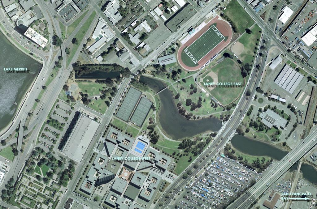
2 OVERVIEW The artist team of Lewis desoto and John Roloff have created an preliminary conceptual plan of art programs for the Oakland Estuary Channel. Our approach is systemic, making art that forms the basis for future cultural programming and engages with local/global conversations about culture and nature. We have also introduced ideas for surface treatments and sculptural elements throughout the area.
3 Part of the project is paid for by funds from Measure DD. Other parts of the art program lie outside the purview of Measure DD and connect directly with Peralta Community College District areas. In order for this plan to be developed further, it is vital that PCCD become involved in the evolution of these early ideas.
4
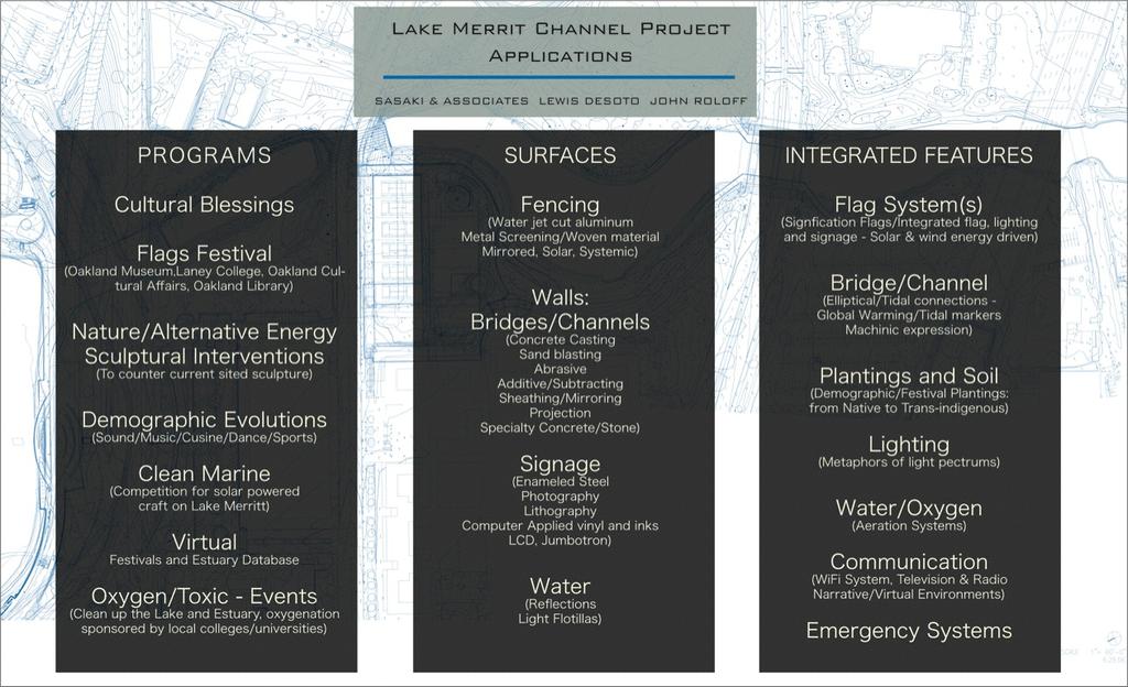
5 ART CONCEPTS The artist team of Lewis desoto and John Roloff developed a structure of Programs, Surfaces and Integrated Features. Many of these Programs can be used and integrated by the PCCD for educational purposes. Many of the projects in Integrated Features allow these programs to be realized.
6 QUESTIONS INFORMING OUR PROCESS "Considering mayor-elect Dellums vision for Oakland as a global model, in what way could the Estuary Channel site be instrumental in engaging Oakland in the critical cultural and natural questions of our time at the local and global levels?" "Could a major landmark feature, such as a sculpture, bridge or other structure be considered an asset/destination point and catalyst, for the Estuary Channel project?"
7 "If the Estuary Channel site were transformed into a locus for innovative culture and nature-based festivals, programs and research, what kind of events and programs are possible and through what process?" "Coordinating with the Peralta Community Colleges and the larger community, what innovative programs, integrating education about culture and natural systems are possible to implement at the Estuary Channel site?"
8
9 CHANNEL WALL TEXT WORKS DeSoto/Roloff propose large inverted text panels beneath the 10th St. bridge designed to be read as reflections on the water surface. The text references the geologic age of the stratigraphic and tectonic structures beneath the Estuary site. The text design references the Kaiser Auditorium style of supergraphics.

10
11 PEDESTRIAN/BICYCLE BRIDGE The small pedestrian bridge that currently crosses over the Estuary Channel does not meet ADA requirements. DeSoto/Roloff have proposed creating a signature design bridge, that creates the feeling of transparency and synesthesia as one moves across it. This design creates two paths, one for bicycles and one for pedestrians.

12
13 PEDESTRIAN/BICYCLE BRIDGE (cont.) In one of the designs a central platform allows for observation/ contemplation and as a stage for cultural performances. The bridge can also become a water aeration device and a platform for experiments for the sciences. This signature style bridge would bring more of the public in contact with the PCCD as it becomes a significant visual landmark, a destination.

14
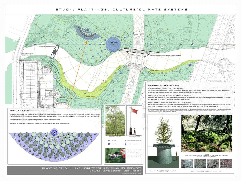
15 PLANTING SYSTEMS A Demographic Garden is proposed that links the diverse peoples of Oakland to plantings that return them to their origins; containing medicinal and symbolic plants from various global sources. This garden would be used by the Horticultural and other Sciences for research and maintenance. Black oak, a primary food source of the Ohlone people, is planted at the center of this garden, and in a radiating pattern across the site interspersed with a flag/information system related to programs and festivals. Other planting relate to ecology, paleoclimates and global interactions/conversations.
16
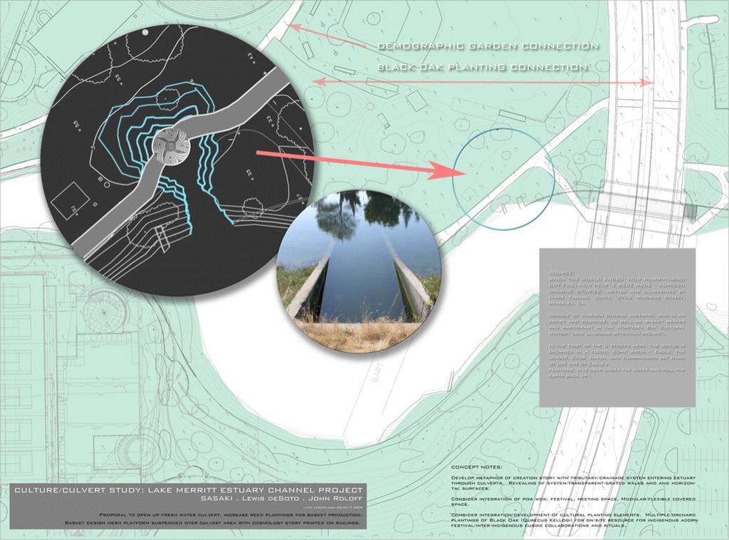
17 FRESHWATER CULVERT DeSoto/Roloff also propose that a fresh water culvert be opened to allow the growing of fresh water reeds that can be utilized to learn and preserve the practice of the Ohlone People, used for millennia to make baskets and other cultural objects. The Freshwater Culvert Area is related to larger demographic plantings and becomes a center for programing and festivals.
18
19 CULTURE/NATURE SIGNIFICATION SYSTEMS A range of systems and markers to represent and celebrate cultural and natural relationships: Oakland Sister Cites, climatic change, geologic biologic and community-based subjects. A flagpole system of different scales: a 100 meter high pole with an energy-producing flag to integrated flag, seating, wind powered lighting and information kiosks distributed throughout the site. Flags designed by PCCD and community for rotating events and festivals are related to flag design and creation. Exchange programs between Oakland Sister Cities, scientific recording and marking instruments/structures, water oxygenation systems, alternative energy and inter-species relationship/migration projects.

20
21 7TH STREET BRIDGE - BYPASS CHANNEL The passages beneath the 7th street bridge are being redesigned to increase the tidal flow between Lake Merritt and the Oakland Estuary. DeSoto/Roloff propose a series of optically expanding, flow demarkation treatments to make the pedestrian and small craft journey through these passages a phenomenological experience and adventure. Carefully arranged, mirrored stainless steel panels and lighting, optically expand spacial and hydrologic phenomena. Linings of cast flow structures mimic hydro/geologic formations. A potential site for a model tide-generated energy system.

22
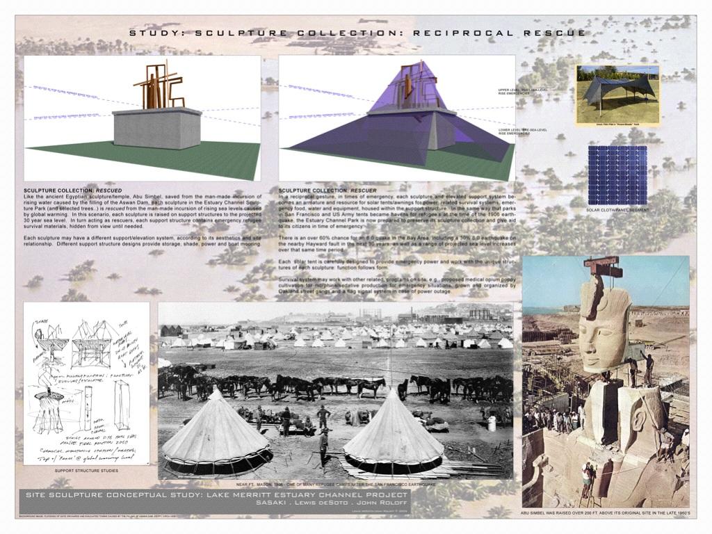
23 SITED SCULPTURE: RECIPROCAL RESCUE The Estuary Channel Sculpture Collection is presently controversial and in a state of neglect. DeSoto/Roloff propose a dual (reciprocal) system to extend the physical, conceptual and cultural relationship of the sculpture to the estuary site. The sculpture is rescued, like Abu Simbel, from the rising seas of global warming (and controversy) by elevation on plinths packed with emergency supplies. The sculptures become armatures for survival. In times of emergency, as during the 1906 earthquake, parks become refuge sites. The Estuary Channel space is now prepared to aid its citizens.
24
25
AREA-WIDE PEDESTRIAN AND BICYCLE CIRCULATION
 OUSD LANEY CHILD CARE CENTER ART BUILDING LANEY COLLEGE BALL FIELDS PCCD OFFICES PERALTA PARK AQUATIC CENTER & ESTUARY PARK EDOFF MEMORIAL BANDSTAND SNOW PARK COURT HOUSE OAKLAND MUSEUM OAK ST AREA-WIDE
Illustrative Development Plan
 Illustrative Development Plan December 7, 005 045 Sansome St., Studio 3 San Francisco, CA 94 Area A - Increase visibility to waterfront and aquatic center from the Embarcadero - Provide streets rather
Published by the Press and Information Office, Republic of Cyprus
 The Cyprus Presidency Presentation of the artistic decoration of the Justus Lipsius Building created by the Cyprus Presidency of the Council of the European Union. Message in a logo The logo of the Cyprus
Sustainability, Health, Safety, Recreation & Open Space Working Group August 3, 2017
 Sustainability, Health, Safety, Recreation & Open Space Working Group August 3, 2017 DOWNTOWN OAKLAND SPECIFIC PLAN WELCOME Sustainability, Health, Safety, Recreation & Open Space Working Group Social
San Francisco General Plan Preservation Element: Objectives 7-9. Historic Preservation Commission August 20, 2014
 San Francisco General Plan Preservation Element: Objectives 7-9 Historic Preservation Commission August 20, 2014 Preservation Element Definition An element of the General Plan that establishes a long-range
The Boardman Restoration Project: Integrating Tribal Perspectives from Technical to Traditional Values In Guiding Ecological Recovery
 The Boardman Restoration Project: Integrating Tribal Perspectives from Technical to Traditional Values In Guiding Ecological Recovery Brett Fessell Fish and Wildlife Coordinator Grand Traverse Band of
Streets, Connectivity & Built Environment Working Group August 2, 2017
 Streets, Connectivity & Built Environment Working Group August 2, 2017 DOWNTOWN OAKLAND SPECIFIC PLAN WELCOME Streets, Connectivity & Built Environment Working Group Social Equity Meeting August 2, 2017
Village of Pemberton DOWNTOWN ENHANCEMENT INITIATIVE FRONTIER STREET PILOT PROJECT WE NEED YOUR HELP TO REVIEW THE PLAN
 Village of Pemberton DOWNTOWN ENHANCEMENT INITIATIVE FRONTIER STREET PILOT PROJECT WELCOME TO THE NEW FRONTIER STREET! WE NEED YOUR HELP TO REVIEW THE PLAN The Village of Pemberton would like your feedback
M E M O R A N D U M. DATE: July 19, Patrick D. O Keeffe, City Manager. Economic Development & Housing
 M E M O R A N D U M DATE: July 19, 2011 TO: FROM: Patrick D. O Keeffe, City Manager Economic Development & Housing SUBJECT: Resolution of the City Council of the City of Emeryville Approving the Application
Allegretti Architects & Andrews University
 1 Allegretti Architects & Andrews University Western Michigan University Arts Plaza Design Charrette Team Members: John W. Allegretti, FAIA Carey Carscallen, Director of Architecture, Andrews University
SBPO BOARD MEETING MARCH 20, 2018
 SBPO BOARD MEETING MARCH 20, 2018 TODAY'S AGENDA > Booker Middle School Outreach > Property Information > Schedule > Guiding Principles > Three Concepts Booker Middle School Outreach Property Information
Market Place Bythell Place Queen Street Park Riverside Park. Public Spaces. Blenheim CBD Streetscape Final Report 36
 37 39 41 43 Market Place Bythell Place Queen Street Park Riverside Park Final Report 36 Market Place Market Place is a key space for Blenheim s street life, it is a meeting place, retail edge and pedestrian
Thousand Oaks Downtown Core Master Plan. Master Plan Open House April 26, 2018
 Thousand Oaks Downtown Core Master Plan Master Plan Open House April 26, 2018 The Site Community Outreach Events Online Community Survey (March 17 - April 22, 2018) 689 responses Pop-Up Workshops Oaks
CASE STUDY: MCGREGOR COXALL SYDNEY, AUSTRALIA. McGregor Coxall
 CASE STUDY: MCGREGOR COXALL SYDNEY, AUSTRALIA 1 REVITALIZING THE SPACE WHERE THE WATERS MEET For the Australian landscape architecture and urban design firm, a design has to be more than just a quick solution
PLAN ELEMENTS WORKSHOP. April 5, 2016
 PLAN ELEMENTS WORKSHOP April 5, 2016 needs more housing. But there is no one-size fits-all solution. Every neighborhood has its own character. In some places, density is not only appropriate it is badly
Planning Stage. Mosaic Park. Long Term Project. Restoration of 4 Mile Run. Planning Stage. Herndon and 13 th. Project Underway. Clarendon Central Park
 Planning Stage Long Term Project Planning Stage Project Underway Mosaic Park Restoration of 4 Mile Run Herndon and 13 th Clarendon Central Park Arlington County Parks, Recreation and Cultural Resources
The Five Components of the McLoughlin Area Plan
 The Five Components of the McLoughlin Area Plan This documents contains the complete language of the five components of the McLoughlin Area Plan: The Vision Statement The Values The Guiding Principles
San Francisco Bay Pilot: Sausal Creek Community Leader Charrette May 11, 2016 Marcus Griswold
 San Francisco Bay Pilot: Sausal Creek Community Leader Charrette May 11, 2016 Marcus Griswold 1 Overview Project Overview Watershed Context Assets and Challenges Opportunities Green Streets Creek Access
Memorials, Plaques & Interpretive Signs Policy
 Memorials, Plaques & Interpretive Signs Policy APPROVAL COUNCIL DATE / CEO VERSION NO: Version 0.4 TRIM REF: 16/31097 REVIEW 30 June 2020 RESPONSIBLE EXECUTIVE General Manager City Assets & Environment
New Brighton Park Shoreline Habitat Restoration Project
 Vancouver Board of Parks and Recreation and Port Metro Vancouver New Brighton Park Shoreline Habitat Restoration Project Conceptual Design Public Consultation August 26 September 9, 2015 Discussion Paper
ARCADIAN THAMES WALKS
 Thames Landcape Strategy Hampton to Kew Annual Review 2008 15 ARCADIAN THAMES WALKS Below is one of the TLS Arcadian Thames Walks that will lead you around the fascinating River Thames on your doorstep.
Annual Report Asociación Cívica de Nosara
 Annual Report Asociación Cívica de Nosara - 2017 LETTER FROM PRESIDENT Dear Members, 2017 was another busy year for the NCA. We continued to make progress on our three main priorities - beach protection,
Landscape Architecture (LARC)
") Landscape Architecture (LARC) 1 Landscape Architecture (LARC) Courses LARC 0841. Sustainable Design. 3 Credit Hours. What's the big deal about global warming and how should we respond to it? Explore the
Landscape Architecture (LARC) 1 Landscape Architecture (LARC) Courses LARC 0841. Sustainable Design. 3 Credit Hours. What's the big deal about global warming and how should we respond to it? Explore the
Welcome. Community Consultation Meeting November 28, Review and discuss the Bathurst Quay Neighbourhood Plan Framework
 Welcome Community Consultation Meeting November 28, 2016 Why Are We Here Today? Review and discuss the Bathurst Quay Neighbourhood Plan Framework Review and discuss an Action Plan for Implementation Next
the village at market creek
 the village at market creek executive summary october 2012 i ii introduction The Village at Market Creek is primed to grow into one of San Diego s most lively, multi-cultural arts destinations. Our community
STAFF REPORT Agenda Item: J.4 To: Mayor and City Council Date:
 STAFF REPORT Agenda Item: J.4 To: Mayor and City Council Date: 2-14-2007 Thru: Charles McNeely, City Manager Subject: Staff Report: Approval of a project to be submitted for the NDOT 2007-2009 Landscape
SLIDE TITLE. TRANSIT AGENCIES AND COMMUNITY PLANNING Case Study in Supporting TOD with the Chicago Transit Authority TRANSPORT CHICAGO 2017
 SLIDE TITLE TRANSIT AGENCIES AND COMMUNITY PLANNING Case Study in Supporting TOD with the Chicago Transit Authority 1 INTRODUCTION WELCOME Steve Hands, Senior Manager for the Chicago Transit Authority
CIVITAS CIVITAS CIVITAS CIVITAS CIVITAS CIVITAS CIVITAS CIVITAS CIVITAS CIVITAS CIVITAS CIVITAS CIVITAS CIVITAS CIVITAS CIVITAS
 7. The Vision 80 East River Esplanade Vision Plan Site Specific Visions Through research, analysis, outreach, and discussions with city and state agency representatives, it became apparent that a phased,
MISSISSIPPI GORGE REGIONAL PARK MASTER PLAN
 MISSISSIPPI GORGE REGIONAL PARK MASTER PLAN Minneapolis Park and Recreation Board CAC MEETING #1 APRIL 23, 2018 AGENDA Mississippi Gorge Regional Park Master Plan CAC #1 01 / Welcome and Calling Circle
Bourne Downtown Site Planning
 Prepared for: The Town of Bourne, MA In Cooperation with: Bourne Financial Development Corporation Prepared by:, Inc. June 24, 2009 Table of Contents Introduction and Summary... 1 Site Existing Conditions...
Animating the Rideau Canal December 2013
 Executive Summary Animating the Rideau Canal December 2013 Why study the Rideau Canal? The Rideau Canal has been an important part of Ottawa throughout its history, and has shaped and been shaped by the
Shoreline Master Program Town of La Conner, Washington
 Shoreline Master Program Town of La Conner, Washington Department of Ecology approval effective Adopted September 24, 2013 by Town of La Conner Ordinance No.1106 Amended May 13, 2014 by Town of La Conner
Scope of Services. River Oaks Boulevard (SH 183) Corridor Master Plan
 Corridor Master Plan") Scope of Services River Oaks Boulevard (SH 183) Corridor Master Plan PROJECT AREA The project area consists of the River Oaks Boulevard (SH 183) corridor bounded by SH 199 at the northern end and the Trinity
Scope of Services River Oaks Boulevard (SH 183) Corridor Master Plan PROJECT AREA The project area consists of the River Oaks Boulevard (SH 183) corridor bounded by SH 199 at the northern end and the Trinity
The Corporation of Delta. COUNC~L REPORT Regular Meeting. Burnsview Secondary School/Chalmers Park Memorandum of Understanding
 The Corporation of Delta COUNC~L REPORT Regular Meeting Fa 13 To: Mayor and Council File No.: 14035-20/ChaP From: Parks, Recreation & Culture Department Date: June 19, 2015 Burnsview Secondary School/Chalmers
Strategy and Action Plan for the Protection of Biological and Landscape Diversity of the Republic of Croatia
 Strategy and Action Plan for the Protection of Biological and Landscape Diversity of the Republic of Croatia Republic of Croatia Ministry of Culture Nature Protection Directorate Ivna Vukšić Isle of Vilm,
CITYWIDE PLANNING DIVISION
 2014-2019 CITYWIDE PLANNING DIVISION a five-year work program for long-range planning November 2016 TODAY S PRESENTATION 1. Overview 2. Planning Priorities 3. Topics/Focus Areas 5. Essential Practices
City of Brookfield 2035 Comprehensive Plan. DRAFT #2 October 6, 2009
 City of Brookfield 2035 Comprehensive Plan DRAFT #2 October 6, 2009 Public Hearing Presentation: December 1, 2009 Process Overview Phase I: Community Visioning (2008) - Developed long-term vision to direct
ROUND ONE PROJECTS. Capital Grants 18 DELAWARE VALLEY REGIONAL PLANNING COMMISSION
 ROUND ONE PROJECTS DVRPC awarded the first round Take Me to the River grants in 2008 (see Figure 5 for project locations). The 13 projects selected were chosen based on their ability to reconnect citizens
TWIN CITY MONUMENT SIGN - BAGUIO CITY CENTENNIAL PARK. The Director of Economic Development in consultation with the City Manager, recommends:
 ECONOMIC DEVELOPMENT COMMITTEE AUGUST 30, 2010 TWIN CITY MONUMENT SIGN - BAGUIO CITY CENTENNIAL PARK Recommendation The Director of Economic Development in consultation with the City Manager, recommends:
Isabel Neighborhood Plan: Alternatives
 Isabel Neighborhood Plan: Alternatives Presented by: Lori Parks, Associate Planner February 2, 2015 Agenda 1. Background on BART to Livermore 2. Isabel Neighborhood Plan 3. Alternative Scenarios 4. General
SLIDE TITLE TRANSIT-ORIENTED DEVELOPMENT PLAN RED-PURPLE BYPASS STUDY AREA PUBLIC MEETING #2 RED AND PURPLE MODERNIZATION. RPM TOD Plan Update
 SLIDE TITLE TRANSIT-ORIENTED DEVELOPMENT PLAN RED-PURPLE BYPASS STUDY AREA PUBLIC MEETING #2 RED AND PURPLE MODERNIZATION 1 SLIDE TITLE AGENDA Project Introduction TOD s and Development Trends Real Estate
Call for Artists for: Design and Construction of Environmental Art Activation Story Mill Community Park, Bozeman, MT
 Call for Artists for: Design and Construction of Environmental Art Activation Story Mill Community Park, Bozeman, MT Seeking artists to design, fabricate and install art elements in the nature sanctuary
1.1 WATERFRONT SEATTLE
 1.1 WATERFRONT SEATTLE Over the past few years, the City of has been actively re-imagining the future of its Central Waterfront. The imminent replacement of the Elliott Bay Seawall and removal of the Alaskan
3.0 master plan concept
 3.0 master plan concept 3.1 introduction The purpose of the Huron Church Road Master Plan Concept is to provide an overview of the Master Plan design process, identify preliminary streetscape installations
ELK GROVE GENERAL PLAN VISION
 2-1 CHAPTER 2: 2-2 CREATING OUR The Community Vision for Elk Grove, expressed through a Vision Statement and a series of Supporting Principles, is a declaration of the kind of community that Elk Grove
Landscape Conservation and Sustainable Development
 MRSS1123 Landscape Conservation and Sustainable Development Khairul Kamarudin October 2017 DEVELOPMENT CONSERVATION SUSTAINABLE DEVELOPMENT LANDSCAPE DEFINITION Landscape is the environment experienced
Chapter 9: Economic Development
 Chapter 9 Economic Development Goal To embrace a stable, prosperous business environment focused on industry diversity, yielding family income sufficient to support education, recreation, social and cultural
Public Art Plan. We have elected to submit Public Art Plans before or concurrently with the CSP Submittal per the FDP Manual
 Public Art Plan The intent of the Horizon Uptown Public Arts Program is to create great places that engage the community and leverage the neighborhood development and economic vitality. The Horizon Uptown
Midtown Greenway to lake street
 Making the connection: Midtown Greenway to lake street May 2016 Design experiment: site amenities, wayfinding, and activities at Cepro, near the Midtown Global Market Recent Greenway Development Highlights
CENTRAL ESTUARY PLAN AVISION FOR OAKLAND S WATERFRONT
 Central Estuary Plan A VISION FOR OAKLAND S WATERFRONT Specific Plan and Environmental Assessment Presentation to the Parks and Recreation Advisory Commission December 9, 2009 This Afternoon s Presentation
Inclusive and Engaging City
 Inclusive and Engaging City An Inclusive City welcomes and enables all people to participate fully in City life. Population, housing, services, social inclusion and liveability are important elements of
Pontchartrain Coastal Lines of Defense Program Figure 1 Figure 2 Figure 1
 Pontchartrain Coastal Lines of Defense Program Coastal Sustainability Program February 2006 The Pontchartrain Coastal Lines of Defense Program consists of ten priority project areas within the Pontchartrain
I-1 COMMENCEMENT. History
 COMMENCEMENT Nature connects us to each other. All of creation has developed from natural processes, and thus by instinct, we are drawn back into them. Whether it be a forest, prairie, beach or community
Moving from Vision to Action
 Moving from Vision to Action Photo: John Carvalho What does it mean for a city to move? To see its people belong and connect? To prosper? To become green? Those are the pillars that are helping Mississauga
The Town of Chrudim With Local Agendou 21 Towards Higher Quality of Life Whole City Awards
 The Town of Chrudim With Local Agendou 21 Towards Higher Quality of Life Whole City Awards Chrudim is an old town (the first written mention dates back to 1055) with a rich history and numerous cultural
Executive Summary. Section II: Objectives Issues & Opportunities. Section III: District Recommendations. Oak-to-Ninth Avenue District
 The Oakland Estuary Policy Plan is amended as follows: Executive Summary Page vi The plan proposes the large-scale transformation of the area from the Lake Merritt Channel to the Ninth Avenue Terminal
10 Principles for a Sustainable Development of Urban Waterfront Areas
 10 Principles for a Sustainable Development of Urban Waterfront Areas In the context of the initiatives for the Global Conference on the Urban Future (URBAN 21) held in Berlin in July 2000 and in the course
An Honors Thesis (Arch 402)
") Art + Architecture An application of art and culture from around the world An Honors Thesis (Arch 402) by Kathleen Strigle Thesis Advisor Rod underwood ) BaU State University Muncie, Indiana May 2014 Expected
Art + Architecture An application of art and culture from around the world An Honors Thesis (Arch 402) by Kathleen Strigle Thesis Advisor Rod underwood ) BaU State University Muncie, Indiana May 2014 Expected
WEST OAKLAND SPECIFIC PLAN & DRAFT ENVIRONMENTAL IMPACT REPORT
 WEST OAKLAND SPECIFIC PLAN & DRAFT ENVIRONMENTAL IMPACT REPORT Landmarks Preservation Advisory Board Public Hearing February 10, 2014 1 Specific Plan Overview Plan Area is generally bounded by I-580 to
Please read the entire document
 projects impacting the waterfront revitalization area. The waterfront revitalization area of the town will have to subareas to the west and east of the village. Page 6 of 6 Wayfinding master plan create
TABLE OF CONTENTS CHAPTER TITLE PAGE DECLARATION DEDICATION ACKNOWLEDGEMENTS ABSTRACT ABSTRAK
 vii TABLE OF CONTENTS CHAPTER TITLE PAGE DECLARATION DEDICATION ACKNOWLEDGEMENTS ABSTRACT ABSTRAK TABLE OF CONTENTS LIST OF FIGURES LIST OF TABLES LIST OF ACROYMS LIST OF APPENDIXES ii iii iv v vi vii
Executive Summary Purpose of the Plan Defining Open Space and Greenways
 Executive Summary Bucks County possesses a vast array of open space resources including natural areas, parks, farmland and historic and cultural resources that contribute to a high quality of life valued
6.0 Recreation and Open Space
 6.0 Recreation and Open Space Goal 1: Provide Recreation and Open Space Facilities In Close Proximity to the University Population to Support Healthy Lifestyles, and Adequately and Efficiently Serve the
MCCOYS CREEK RESTORATION 30% DESIGN
 MCCOYS CREEK RESTORATION 30% DESIGN THE MCCOYS CREEK RESTORATION PLAN The restoration plan aims to reduce flooding, restore ecosystem health, expand recreational opportunities along the creek, and connect
Conserving Nature Through Tourism? Issues of tourism and Protected Areas. Professor Andrew Holden
 Conserving Nature Through Tourism? Issues of tourism and Protected Areas Professor Andrew Holden Kenya video https://www.youtube.com/watch?v=rdck9 SgdEZY Reflection What does the term natural environment
2035 General Plan Update and Belmont Village Specific Plan. Joint Study Session with the City Council and Planning Commission April 12, 2016
 2035 General Plan Update and Belmont Village Specific Plan Joint Study with the City Council and Planning Commission April 12, 2016 Agenda 1. Welcome and Introductions 2. General Plan Update Status of
Public input has been an important part of the plan development process.
 Lakewood s Comprehensive Plan recognizes that transportation helps shape the community, and that the way the community provides for the safe and efficient movement of people affects the character of the
About Momentum Midland
 About Momentum Midland Achieving a community s full potential in terms of economic development and quality of life is critically important to its long term sustainability. Core to achieving this is a vibrant
Support the implementation of Cape Coral's Comprehensive Plan. Protect and utilize the unique natural resources in the City.
 7.0 OVERVIEW - RECOMMENDATIONS Chapter 7 The preparation of the Cape Coral Parks and Recreation Master Plan spanned a period of approximately 12 months. Plan preparation included the input of a wide range
MAGALIESBURG DEVELOPMENT INITIATIVE (MDI)
") INTRODUCTION The recently launched Magaliesburg Development Initiative (MDI) is a combination of technical and professional input based on an approved municipal precinct plan, a deliberate emphasis on
INTRODUCTION The recently launched Magaliesburg Development Initiative (MDI) is a combination of technical and professional input based on an approved municipal precinct plan, a deliberate emphasis on
DESIGN STRATEGIES LESTER RIVER NEIGHBORHOOD: AREA CHARACTER DESCRIPTION OF PHOTOGRAPHS: LESTER RIVER NEIGHBORHOOD: OBLIQUE VIEWS
 DESIGN STRATEGIES LESTER RIVER NEIGHBORHOOD: AREA CHARACTER Visual analysis of the Lester River Neighborhood reveals the valuable resources throughout the area. In many ways it is here at the Lester River
CITY OF HAMILTON PUBLIC WORKS DEPARTMENT Environmental Services Division
 CITY OF HAMILTON PUBLIC WORKS DEPARTMENT Environmental Services Division TO: Chair and Members Public Works Committee COMMITTEE DATE: July 12, 2018 SUBJECT/REPORT NO: WARD(S) AFFECTED: PREPARED BY: SUBMITTED
Corridor Vision. 1Pursue Minnehaha-Hiawatha Community Works Project. Mission of Hennepin County Community Works Program
 1Pursue Minnehaha-Hiawatha Community Works Project Minnehaha-Hiawatha Community Works is a project within the Hennepin Community Works (HCW) program. The mission of the HCW program is to enhance how the
Prepared by: a for the of the. Waterspace Strategy Sustainable Development Liverpool South Docks
 Prepared by: a for the of the Waterspace Strategy Sustainable Development Liverpool South Docks a Waterspace Strategy for the Sustainable Development of the Liverpool South Docks British Waterways identified
Presentation at 4MRV Working Group. Jeffrey Zeeman Arlington Commission for the Arts
 Presentation at 4MRV Working Group Jeffrey Zeeman Arlington Commission for the Arts Creation of official Arts District along several full blocks of South Four Mile Run Drive Maintain / enhance some compatible
Crazylegs Plaza & Wingra Park Entrance: Mosaic Art Input Session. November 8, 2017
 Crazylegs Plaza & Wingra Park Entrance: Mosaic Art Input Session November 8, 2017 Thank you to HotelRED! Agenda 1. Project Overview Team and scope Public art context Approved site designs & input to-date
THE NEIGHBORHOOD TODAY
 THE NEIGHBORHOOD TODAY CORE AREA VISION How are we Good Urbanism A Site s DNA thinking about Elements of great Unique elements urban communities embedded in a place the site and design? ELEMENTS LIKE:
Yorkshire Sculpture Park Historic Landscape Management Plan. Volume I. July 2010
 Yorkshire Sculpture Park Historic Landscape Management Plan Volume I July 2010 T: 01904 691630 www.landscapeagency.co.uk enquiries@landscapeagency.co.uk Contents 3 Volume I Historic Landscape Management
1 October Dear Citizens of Charlotte and Mecklenburg County,
 1 October 2011 Dear Citizens of Charlotte and Mecklenburg County, As co-chairs of the Center City 2020 Vision Plan Steering Committee, we are proud to present the Center City 2020 Vision Plan, which sets
TREASURE ISLAND PHASE ONE PROJECTS PUBLIC ART PROJECT OUTLINE
 TREASURE ISLAND PHASE ONE PROJECTS PUBLIC ART PROJECT OUTLINE BACKGROUND (DEVELOPMENT PROJECT OVERVIEW) The Treasure Island Development is an approved 405-acre redevelopment project on Treasure Island
PARTF Scoring System for Grants
 PARTF Scoring System for Grants The members of the N.C. Parks and Recreation Authority use the PARTF scoring system as one of several tools to select grant recipients. Please provide all of the information
PHASE 3-4 PARKS SOUTH PARK AND CHANNEL PARK
 PHASE 3-4 PARKS SOUTH PARK AND CHANNEL PARK Sheet List L1.0 L2.0 L3.0 L4.0 L5.0 L6.0 L7.0 L8.0 L9.0 L10.0 L11.0 L12.0 L13.0 L14.0 L15.0 L16.0 L17.0 L18.0 L19.0 L20.0 L21.0 L22.0 Cover Open Space Context
MARINA MARKET & WATERFRONT DEVELOPMENT STUDY PORT ARANSAS, TEXAS
 MARINA MARKET & WATERFRONT DEVELOPMENT STUDY PORT ARANSAS, TEXAS FEBRUARY 2015 PRESENTATION OUTLINE 1 2 3 4 5 6 7 REGIONAL POSITIONING SITE IMPRESSIONS PLANNING & DESIGN PRINCIPLES EXISTING IMPROVEMENTS
Burnside Gorge Neighbourhood Plan. Engagement Summary
 Burnside Gorge Neighbourhood Plan Engagement Summary Table of Contents Engagement Summary... 3 Phase One Engagement (April May 2015)... 4 Phase Two Engagement (January March 2016)... 4 Appendix One: Summary
The Napa River Flood Protection Project
 The Napa River Flood Protection Project Creating Flood Protection and Restoring Geomorphic and Biological Processes Jeremy Sarrow, Napa County Flood Control & Water Conservation District June 2, 2014.
Planning for Staten. Habitat Restoration and Green Infrastructure. Island s North Shore
 Habitat Restoration and Green Infrastructure Planning for Staten Island s North Shore Community Board 1 March 1, 2018 NYC Parks Forestry, Horticulture, and Natural Resources Funded by the NYS Department
6. DOWNTOWN. The Downtown Element focuses on supporting and expanding the vitality and enhancement of Downtown Chico as the City s central core.
 VISION In 2030, Downtown Chico is the heart of the community and the center of cultural activity. Engaging and active at the street level, it is a multi-story, mixed-use hub, with specialty retail, restaurants,
Highest & Best Use Study Marina Park Lands
 Executive Summary of Report MARCH 2006 TABLE OF CONTENTS 1. Introduction...1 2. Study Process...2 3. Highest And Best Use Program...3 4. Concept Plan...8 5. Public Area Animation...9 6. Marina Park Implementation
Complete Streets in Lancaster County
 Complete Streets in Lancaster County PRESENTED BY: Robert Bini, AICP Director for Transportation Planning November 14, 2017 Lancaster County is a growing county of over 534,000 and the bottom line is...
A Study on Landscape Design Paradigm from the Perspective of Visual Impact and Experience
 2017 3rd International Conference on Social Science, Management and Economics (SSME 2017) ISBN: 978-1-60595-462-2 A Study on Landscape Design Paradigm from the Perspective of Visual Impact and Experience
Figure 3-1: Public Realm Plan
 3 Public Realm Figure 3-1: Public Realm Plan 3.1 Public Realm Concept The public realm concept for the Little Mountain site integrates a clear and accessible movement network with public spaces for social
2014: A Year in Review
 The State of Our City is Strong AAA Bond Rating Highest Possible Rating Happiest City in America National Bureau for Economic Research Most Exciting Place in VA Movoto Real Estate New American Foodie Cities
WEATHER IT TOGETHER. The Annapolis Model for Cultural Resource Adaptation Planning. Cultural Resources, Disaster Resilience, and Climate Uncertainty
 WEATHER IT TOGETHER The Annapolis Model for Cultural Resource Adaptation Planning Cultural Resources, Disaster Resilience, and Climate Uncertainty Historic Annapolis A Colonial Capital: National Landmark
SH 199 Corridor Master Plan. Community Meeting No. 2 May 31, 2017
 Community Meeting No. 2 May 31, 2017 Transportation Projects On or Near SH 199 SH 199 from 0.3 miles south of FM 1886 to south end of Lake Worth bridge Construct freeway mainlanes and frontage roads 10-Year
University of Saskatchewan CAMPUS MASTER PLAN. Senate Meeting Preliminary Presentation. April 21, 2018 DIALOG ECS DA WATT
 University of Saskatchewan CAMPUS MASTER PLAN Senate Meeting Preliminary Presentation April 21, 2018 DIALOG ECS DA WATT project process presentation agenda Stakeholder Engagement Project Control phase1
I-70 Corridor Enhancement Plan
 i - Table of Contents Table of Contents Chapter I Overview Chapter II Bridge and Roadway Improvements Chapter III Landscape Enhancements Chapter IV Riparian Corridors Chapter V Showcase Missouri Plan Chapter
IDENTIFICATION TO IMPLEMENTATION THE JOURNEY OF CITY RESILIENCE
 IDENTIFICATION TO IMPLEMENTATION THE JOURNEY OF CITY RESILIENCE Cities are dynamic, living and growing entities. They are centers of art, heritage and cultural pride and their vibrancy attracts visitors,
A playground for the arts and cultural experiments. Governors Island (New York)
") A playground for the arts and cultural experiments Governors Island (New York) 2 A platform for artistic and aesthetic democracy Socrates Sculpture Park (Long Island City, New York) 3 Military, the World's
A playground for the arts and cultural experiments Governors Island (New York) 2 A platform for artistic and aesthetic democracy Socrates Sculpture Park (Long Island City, New York) 3 Military, the World's
Public Meeting & Workshop 1 April 26,2016
 Public Meeting & Workshop 1 April 26,2016 Northeast Ohio Areawide Coordinating Agency City of Cleveland ODOT Bike Cleveland Downtown Cleveland Alliance Ohio City Incorporated Warehouse District Agenda
York Road Arial View
 Arial View Bridge Ave YORK ROAD THE SITE TODAY View west down View west from View east The 1.5 ha site is located south of the and to the east of Queen Street. The site includes an existing car park, disused