Existing Conditions Site Context
|
|
|
- Karin Randall
- 5 years ago
- Views:
Transcription
1
2
3
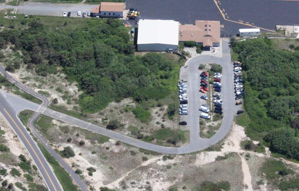
4 Provincetown Municipal Airport Capital Improvement Plan Development of Regional Impact Hardship Exemption Provincetown, MA Cape Cod Commission Public Hearing November 4, 2015 Horsley Witten Group, Inc. Existing Conditions Site Context Existing Infrastructure Freshwater Wetlands Coastal Dunes Cultural Grasslands Coastal Floodplain Rare Species Habitat 1


5 Existing Conditions Coastal Floodzone Existing Conditions Rare Species Habitat Eastern Box Turtle Eastern Spadefoot Vesper Sparrow MESA Project Review complete 2
6 Proposed Conditions 1. Westerly Taxiway System Improvements 2. Relocate East End Taxiway 3. Reconstruct Terminal Apron completed 4. Reconstruct Easterly End of Taxiway completed 5. Install Taxiway Lighting and Construct Electric Vault 6. Repair Sightseeing Shack 7. Improve Access Road to Approach Light System 8. Construct Service Access Roads to LES and AWOS 9. Install a Perimeter Safety/Security Fence 10.Expand Auto Parking 11.Expand Terminal Building to be deferred 12.Expand Turf Apron Regional / Community Benefit Supports Goals of Regional Policy Plan fosters sustainable economy provides safe and reliable regional transportation options Resources provides on-site and regional mitigation manages invasive species protects water quality protects/restores habitat 3


7 Proposed Conditions Proposed Conditions Improve Access Road to Approach Light System 4
 System")


8 Westerly Taxiway (TW) System Improvements Proposed Conditions Westerly Taxiway System Improvements 5


9 Proposed Conditions Expand Turf Apron Proposed Conditions Relocate East End Taxiway Construct Service Access Roads to LES and AWOS 6


10 East End TW & Access Roadways to AWOS and LES Proposed Conditions Install Taxiway Lighting and Construct Electric Vault Repair Sightseeing Shack 7

11 Proposed Conditions Additional Auto Parking Proposed Conditions Additional Auto Parking 8


12 Install Perimeter Fence Perimeter Fence 9
 Area (sf) Area (sf) Area (sf) Open/Unveg Dune or Open Herbaceous 2,812 3,744 22,324 1,852 708 Low shrubs (PEM/PSS) 952 208 1,704 Dense Shrubs (PSS) 5,926 2,180 Pitch Pine w/o understory")
13 Breakdown of Fence Impacts (to determine secondary impacts to resource areas) SeCONDARY/INDIRECT FENCE IMPACTS BY VEGETATION COVER BVW IVW DUNE Grassland Gravel Vegetation Community Type: Area (sf) Area (sf) Area (sf) Area (sf) Area (sf) Open/Unveg Dune or Open Herbaceous 2,812 3,744 22,324 1, Low shrubs (PEM/PSS) ,704 Dense Shrubs (PSS) 5,926 2,180 Pitch Pine w/o understory (PFO) 1,152 16,550 5,216 Dense Pitch Pine & Shrubs (PFO) Phragmites 5,208 TOTAL TO BE CUT: 1,152 23,204 8,060 Freshwater Wetlands Total Direct Impacts: 83,010 SF (1.91 ac) Westerly Taxiway Improvements 29,465 SF (0.68 ac) East End Taxiway 28,110 SF (0.65 ac) Improve MALSF Access Road 238 SF (<0.01 ac) AWOS Access Road 335 SF (<0.01 ac) Install Perimeter Fence Post Installation 506 SF (0.01 ac) Vegetation Cutting 24,356 SF (0.56 ac) Total Indirect Impacts: 41,304 SF (0.95 ac) 10
14 Coastal Dunes Total Direct Impacts: 44,871 SF (1.03 ac) Westerly TW System Improvements 5,567 SF (0.13 ac) Relocate East End TW LES Service Access Road AWOS Service Access Road Expand Auto Parking (Phase 1) Install Perimeter Fence* *Total Impacts from Change in Vegetation Community 4,781 SF (0.11 ac) 4,768 SF (0.11 ac) 6,595 SF (0.15 ac) 15,100 SF (0.35 ac) 8,060 SF (0.19 ac) *Total Indirect Impacts: 24,028 SF (0.55 ac) Proposed Mitigation On-site Wetland Mitigation BVW Replication at 3:1 Wetland Restoration at 1:1 for all vegetated wetlands Participation in MA In Lieu Fee Program On-site Coastal Dune creation On-site Invasive Species Management Net Reduction in Pavement by 34,111 SF (0.78 ac) Stormwater Management (per MASWMS) Erosion and Sedimentation Control Construction Timing Mitigation Oversight Environmental Monitor Rare Species Protection Plans 11
15 Hardship Exemption CR3.1 Buffers to Coastal Wetlands CR3.3 Stormwater Discharges in 100-foot Buffer WET1.1 Wetlands WET1.2 Wetland Buffers WET1.4 Stormwater Mgt. in 100-foot Buffer Flexibility Sought WR7.8 Min. 2-foot Separation to Groundwater CR2.8 Public Infrastructure in LSCSF CR3.4 Stormwater Mgt to Accommodate SLR 12


16 On-Site Mitigation Restoration Areas A and B: 66,000 SF isolated wetland 5,000 SF BVW 27,000 SF coastal dune Project Plans, Sheet 12 On-Site Mitigation Restoration Area C: 14,000 SF isolated wetland 9,000 SF coastal dune Project Plans, Sheet 13 13
 Provincetown Conservation")
17 On-Site Invasive Species Management Overall Permitting Water Quality Certification (WQC) w/variance MA DEP Individual Permit U.S. Army Corps of Engineers CZM Consistency Review MA Coastal Zone Management Development of Regional Impact Cape Cod Commission Order of Conditions (under Wetlands Bylaw) Provincetown Conservation Commission 14

18 Questions Logistics Schedule Next Steps 15
19
Empowering Local Action for Coastal Resilience in Massachusetts. Bruce K. Carlisle MA Office of Coastal Zone Management
 Empowering Local Action for Coastal Resilience in Massachusetts Bruce K. Carlisle MA Office of Coastal Zone Management Context Coastal communities continue to face both chronic and acute storm surge, erosion,
 Stormwater Management Plan Narrative Quality Fleet Services, Inc. SITE RE-DEVELOPMENT 548 New Ludlow Road South Hadley, MA The project proposed by Quality Fleet Services, Inc. consists of the site improvements
Working Group Meeting
 April 4,, 2017 Parks Operations Bldg Working Group Meeting Arts Districts Overview Stormwater/RPA/Stream Considerations First Principles Agenda 7:00pm 7:05pm 7:10pm 7:40pm 8:30pm 9:40pm 9:45pm Welcome
Date: April 6, Attorney Michael Ford PO Box W. Main Street Harwich, MA Cape Cod Commission
 Date: April 6, 2006 To: From: RE: Applicant: Project: Attorney Michael Ford PO Box 665 72 W. Main Street Harwich, MA 02671 Cape Cod Commission District of Critical Planning Concern (DCPC) Hardship Exemption
The Benefits and Challenges Associated with Green Infrastructure Practices
 The Benefits and Challenges Associated with Green Infrastructure Practices Thomas M. Evans ASLA, LEED AP Regional Green Infrastructure Design Services Director OWEA Technical Conference, June 20, 2013
A. General Information
 Important: When filling out forms on the computer, use only the tab key to move your cursor - do not use the return key. Massachusetts Department of Environmental Protection A. General Information 1. Project
Review Zone Application for D&R Canal Commission Decision
 Review Zone Application for D&R Canal Commission Decision MEETING DATE: July 20, 2016 DRCC #: 16-4803 Latest Submission Received: June 13, 2016 Applicant: Robert McCarthy, PE PSE&G 4000 Hadley Road, 2
MACC Annual Environmental Conference 2017 Series B, Workshop 12 Solar Arrays: Permitting Issues for Commissions to Consider
 MACC Annual Environmental Conference 2017 Series B, Workshop 12 Solar Arrays: Permitting Issues for Commissions to Consider March 4, 2017 Are solar arrays pervious or impervious? Are solar arrays subject
Environmental Consulting & Restoration, LLC Specializing in Wetland and Coastal Resource Area Delineation & Permitting
 Brad Holmes, Manager Professional Wetlands Scientist & Massachusetts Certified Arborist ECR is a small environmental consulting firm specializing in wetland and coastal project permitting and resource
Chagrin River Watershed Partners, Inc. Local Regulations. Amy H. Brennan (440)
") Chagrin River Watershed Partners, Inc. Local Regulations Amy H. Brennan (440) 975-3870 www.crwp.org abrennan@crwp.org July 9, 2013 Applicable Zoning and Building Codes Erosion and Sediment Control Grading
Chagrin River Watershed Partners, Inc. Local Regulations Amy H. Brennan (440) 975-3870 www.crwp.org abrennan@crwp.org July 9, 2013 Applicable Zoning and Building Codes Erosion and Sediment Control Grading
OWNER/APPLICANT: VARSITY WIRELESS INVESTORS, LCC AND BELL ATLANTIC MOBILE OF MASSACHUSETTS CORP ( APPLICANTS )
") STAFF REPORT PROJECT: DRI REVIEW WELLFLEET COMMUNICATIONS CELL TOWER 724 ROUTE 6, WELLFLEET, MA TR15011 OWNER/APPLICANT: VARSITY WIRELESS INVESTORS, LCC AND BELL ATLANTIC MOBILE OF MASSACHUSETTS CORP (
STAFF REPORT PROJECT: DRI REVIEW WELLFLEET COMMUNICATIONS CELL TOWER 724 ROUTE 6, WELLFLEET, MA TR15011 OWNER/APPLICANT: VARSITY WIRELESS INVESTORS, LCC AND BELL ATLANTIC MOBILE OF MASSACHUSETTS CORP (
Cost Effective Low Impact Development
 Cost Effective Low Impact Development An Introductory Guide to Conserve Land, Restore Resources, Protect Water, and Save Money in Massachusetts Stefanie Covino Shaping the Future of Your Community Program
ADDENDUM TO BIOLOGICAL SCOPING SURVEY REPORT, BOTANICAL SURVEY AND WETLAND DELINEATION
 ADDENDUM TO BIOLOGICAL SCOPING SURVEY REPORT, BOTANICAL SURVEY AND WETLAND DELINEATION FOR AVALON INN (APN 069-241-27 & -04) 1201 & 1211 NORTH MAIN STREET FORT BRAGG, CA MENDOCINO COUNTY prepared for:
What is the EDPA? The EDPA has three objectives: 1. Protect biodiversity. 2. Mitigate damage during development. 3. Restore degraded ecosystems
 What is the EDPA? Environmental Development Permit Areas are the best tool available to municipalities to protect ecosystems and habitat on private land. The EDPA has three objectives: 1. Protect biodiversity
Ohlone College Measure G Project Scope Revisions
 Scope Revisions Current Title Revised Title Current Scope Revised Scope 6101 Relocated Baseball Field Athletic Fields Create new sustainable baseball field with synthetic turf, bleacher seating and batting
Final Report: Appendix F. LID Driveway Retrofit at Ocean Spray Processing Facility, Middleboro Supporting Information
 Bridgewater State University Virtual Commons - Bridgewater State University Phase II Final Report Taunton River Watershed Project 2011 Final Report: Appendix F. LID Driveway Retrofit at Ocean Spray Processing
October 26,2006 CERTIFICATE OF THE SECRETARY OF ENVIRONMENTAL AFFAIRS ON THE ENVIRONMENTAL NOTIFICATION FORM
 - - Mil7 ROMNEY GOVERNOR KERRY HEALEY LIEUTENANT GOVERNOR Tel. (617) 626-1000 Fax. (617) 626-1 181 http://www.mass.govlenvir ROBERT W. GOLLEDGE, JR. SECRETARY October 26,2006 CERTIFICATE OF THE SECRETARY
COASTAL MANAGEMENT ELEMENT. Last amended December 6, 2016 as part of the 2016 EAR
 COASTAL MANAGEMENT ELEMENT Last amended December 6, 2016 as part of the 2016 EAR Table of Contents Objective Page 7.1 Development and redevelopment of waterfront properties...7-1 7.2 Agency coordination
6Natural. Environment Development Permit Guidelines
 6Natural Bylaw 2600-2016, being "Official Community Plan Bylaw, 2016" Schedule "A" CITY OF ABBOTSFORD OFFICIAL COMMUNITY PLAN Environment Development Permit Guidelines Part V - 6-1 Area Subdivision or
CAPA ASPHALT & AIRPORT PAVEMENT MARCH 27, 2019
 CAPA ASPHALT & AIRPORT PAVEMENT MARCH 27, 2019 PRESENTERS William Epp, PE, SE Colorado Division Manager Senior Vice President Brett Holt, PE Project Manager WHO WE ARE A nationally recognized transportation
DRAFT Open Space Technical Bulletin
 DRAFT Open Space Technical Bulletin This guidance is intended to clarify how the Open Space Goal and Objectives of the Regional Policy Plan (RPP) are to be applied and interpreted in Cape Cod Commission
LONDONDERRY PLANNING BOARD SITE PLAN APPLICATION & CHECKLIST
 LONDONDERRY PLANNING BOARD SITE PLAN APPLICATION & CHECKLIST Planning Department Date Stamp Design Review Formal Application All information provided and submitted with this Application Checklist shall
Weston s Wetlands, Stormwater, & Open Space
 Weston s Wetlands, Stormwater, & Open Space Weston s Wetlands, Stormwater, & Open Space Conservation Commission Role and Responsibilities Laws that protect wetlands What residents can do to protect wetlands
Vegetated Filter Strips and Buffers
 3.15 Sediment Control Description: Buffer strips (existing vegetation) and filter strips (planted vegetation) are sections of vegetated land adjacent to disturbed areas. They are designed with low slopes
PUBLIC HEARING. DRAFT Environmental Impact Statement. Matthews Memorial Baptist Church Washington, DC October 18, National Capital Region
 National Capital Region DRAFT Environmental Impact Statement PUBLIC HEARING Matthews Memorial Baptist Church Washington, DC October 18, 2007 Introduction Welcome and team introduction Hearing procedures
Town of Windham. Planning Department 8 School Road Windham, ME voice fax
 Town of Windham Planning Department 8 School Road Windham, ME 04062 voice 207.864-5960 fax 207.892.1916 MEMO DATE: TO: Staff Review Committee FROM: Amanda Lessard, Planner Cc: Ellen Rathbone, St. Germain
Constructed Stormwater Wetlands
 Types: Shallow Marsh System, Basin/Wetland System, Extended Detention Wetland, Pocket Wetland F. X. Browne, Inc., Lansdale, PA http://www.fxbrowne.com/html/fxb%20wetland%20cs/fxbi_constructed%20wetland_cs.htm
Municipal Plan*Assessment
 Municipal Plan*Assessment This tool was developed to assist in reviewing municipal master plans and in determining if these plans are consistent with smart growth principles, neighboring municipal plans,
Biodiversity Conservation
 Biodiversity Conservation and Site Plan Review Biodiversity conservation principles Threats to biodiversity Location of development Reviewing site plans Lunch Reviewing site plans (continued) LEED and
KENT COUNTY STORMWATER MAINTENANCE DISTRICT STORMWATER BMPs MAINTENANCE TASKS AND RESPONSIBILITIES GUIDANCE DOCUMENT BIO-RETENTION FACILITIES
 BIO-RETENTION FACILITIES (for all basins / BMPs) Annually Prepare Operation and Maintenance Plan. Clearly outline how vegetation in the facility and its buffer area will be managed or harvested in the
Agenda. NPDES Phase II Program (US EPA, 2003 Pending 2009) Costs of Stormwater Management and How to Structure a Stormwater Utility
 Costs of Stormwater Management and How to Structure a Stormwater Utility") Costs of Stormwater Management and How to Structure a Stormwater Utility Richard Claytor, P.E. Horsley Witten Group, Inc How to Fund Your Municipal Stormwater Program April 30, 2009 Peabody Institute Library
Costs of Stormwater Management and How to Structure a Stormwater Utility Richard Claytor, P.E. Horsley Witten Group, Inc How to Fund Your Municipal Stormwater Program April 30, 2009 Peabody Institute Library
Berkshire Regional Planning Commission Clearinghouse Review Report
 August 19, 2013 SUBJECT: Reconstruction of Housatonic Street, Dalton, MA EOEA#: 15083 LOCATION: Dalton ESTIMATED COST: $8.1 million REVIEW TYPE: ENF PROPONENT: MassDOT and Town of Dalton COMMENTS DUE:
STREAM BUFFERS
 88-415 STREAM BUFFERS 88-415-01 PURPOSE In the Kansas City region and throughout the nation, vegetated stream buffers have been clearly shown to protect stream stability and related infrastructure, improve
WELCOME! 8 8:30 6: TH STREET IMPROVEMENTS. Open House. Presentation & Q&A
 WELCOME! 168 TH STREET IMPROVEMENTS 6:30 Open House 7 8 Presentation & Q&A 8 8:30 Open House WELCOME Todd Pfitzer City of Omaha Engineer Bob Stubbe City of Omaha Public Works Director Jon Meyer Project
Stormwater Drainage Assessment For Single Family Residence
 Stormwater Drainage Assessment For Single Family Residence Project Name: SEADER SFD Project Address: 2301 NE Perkins Way, Lake Forest Park, King County WA. Parcel Number(s): Tax Parcel No. 86659-00181
Green Infrastructure. NYS Department of Environmental Conservation
 Green Infrastructure Green infrastructure is an interconnected network of natural areas and open spaces that sustains ecosystems. Benedict, M.A. and E.T. McMahon. 2006. Green Infrastructure Linking Landscapes
DETERMINATION OF SIGNIFICANCE FOR THE LONGWOOD PUBLIC LIBRARY EXPANSION & RENOVATION; STATE ENVIRONMENTAL QUALITY REVIEW ACT (SEQRA) RESOLUTION
 RESOLUTION") Longwood Public Library Resolution Library Board of Trustees August 13, 2012 DETERMINATION OF SIGNIFICANCE FOR THE LONGWOOD PUBLIC LIBRARY EXPANSION & RENOVATION; STATE ENVIRONMENTAL QUALITY REVIEW ACT
Longwood Public Library Resolution Library Board of Trustees August 13, 2012 DETERMINATION OF SIGNIFICANCE FOR THE LONGWOOD PUBLIC LIBRARY EXPANSION & RENOVATION; STATE ENVIRONMENTAL QUALITY REVIEW ACT
Building Ecological Solutions to Coastal Community Hazards: Guidance and NJ Coastal Community Assistance
 Building Ecological Solutions to Coastal Community Hazards: Guidance and NJ Coastal Community Assistance Stacy Small-Lorenz National Wildlife Federation Restore America s Estuaries Summit New Orleans,
LONDONDERRY PLANNING BOARD MINOR SITE PLAN APPLICATION & CHECKLIST
 LONDONDERRY PLANNING BOARD MINOR SITE PLAN APPLICATION & CHECKLIST Planning Department Date Stamp Design Review Formal Application Change of Use (No Site Improvements)* All information provided and submitted
SLIDE PRESENTATION: DRI Mitigation Slide Show Page
 SLIDE PRESENTATION: This presentation provides an overview of the kinds of mitigation that the Cape Cod Commission may require when reviewing Developments of Regional Impact, or DRIs, and what the benefits
ADMINISTRATION RECOMMENDATION(S) 2017 February 09. That Calgary Planning Commission recommends APPROVAL of the proposed Land Use Amendment.
 2017 February 09. That Calgary Planning Commission recommends APPROVAL of the proposed Land Use Amendment.") Page 1 of 10 EXECUTIVE SUMMARY This land use amendment application is to accommodate changes to the location of a stormwater retention pond and land use boundaries adjacent to Environmental Reserve in
Page 1 of 10 EXECUTIVE SUMMARY This land use amendment application is to accommodate changes to the location of a stormwater retention pond and land use boundaries adjacent to Environmental Reserve in
Innovative Land Use Techniques
 Innovative Land Use Techniques A Handbook for Sustainable Development Eric Williams, Assistant Administrator, NHDES Carolyn Russell, Principal Planner, NHDES Cliff Sinnott, Executive Director, RPC Jill
WETLANDS PROTECTION ACT REFERENCE MANUAL
 WETLANDS PROTECTION ACT REFERENCE MANUAL Table of Contents 1. Wetlands Protection Program a. Wetlands Protection Act: M.G.L. c.131, 40: http://www.mass.gov/legis/laws/mgl/131-40.htm b. Restricted Wetlands:
Springhill Suites by Marriot TR Limited DRI Hearing Hermann Foundation Room Falmouth Public Library
 TR14017 Limited DRI Hearing Hermann Foundation Room Falmouth Public Library Limited DRI Review Mandatory DRI: Sections 3(e) and 3(f) of the Enabling Regulations increase Gross Floor Area on-site by greater
NATURAL ENVIRONMENT DPA 8
 District of design guidelines DPA 8 North Cowichan District of North Cowichan Planning Department For further information: Phone (250) 746 3100 7030 Trans Canada Highway P.O. Box 278, Duncan, B.C. V9L
South Commercial and Rural Fringe Land Use East Rural Fringe Land Use West - Planned Community (Pace Island)
") Revised 11/2/2015 Owners Name: Agent: G & H International Investments LLC 1890 Kingsley Avenue Suite 102 Orange Park, FL 32073 Susan L. Fraser, SLF Consulting, Inc. 3517 Park Street Jacksonville, FL 32205
Revised 11/2/2015 Owners Name: Agent: G & H International Investments LLC 1890 Kingsley Avenue Suite 102 Orange Park, FL 32073 Susan L. Fraser, SLF Consulting, Inc. 3517 Park Street Jacksonville, FL 32205
2.1 Principles & Objectives
 Designing With The Landform 2.1 Principles & Objectives Land planning which integrates the natural features of a site (i.e., designing with the landform ) into the site design is a major component of the
Jennifer McKay, Conservation Administrator & Elizabeth Gladfelter, Chairman, Falmouth Conservation Commission
 Implementation of an Innovative Tool for Cape and Island Towns District of Critical Planning Concern (DCPC) - Protecting the Black Beach/Great Sippewissett Marsh, Falmouth Jennifer McKay, Conservation
PUBLIC NOTICE. us Anny Corps CENAE-R-A FILE NO. NAE
 CENAE-R-A FILE NO. NAE-2007-02926 PUBLIC NOTICE us Anny Corps of Engineers s. New England District 696 Virginia Road Concord, MA 01742-2751 Comment Period Begins: January 15, 2019 Comment Period Ends:
SITE PLAN REVIEW APPLICATION AND CHECKLIST
 SITE PLAN REVIEW APPLICATION AND CHECKLIST PROJECT SUMMARY: Project Name: City/ETA Location: City ETA (Application fee & number of copies needed are based on location) Property Location (Legal Description
6 August 11, 2010 Public Hearing APPLICANT AND PROPERTY OWNER: CAVALIER GOLF AND YACHT CLUB
 6 August 11, 2010 Public Hearing APPLICANT AND PROPERTY OWNER: CAVALIER GOLF AND YACHT CLUB REQUEST: Conditional Use Permit (outdoor recreational facility) STAFF PLANNER: Faith Christie ADDRESS / DESCRIPTION:
Information for File # MHK
 Information for File #2014-03555-MHK Applicant: Corps Contact: Wimmer Communities Marie Kopka Address: 250 N. Sunnyslope Road, Suite 296 Brookfield, Wisconsin 53005 E-Mail: Marie.H.Kopka@usace.army.mil
TERRESTRIAL NATURAL HERITAGE SYSTEM STRATEGY APPENDIX F: MODEL POLICIES FOR THE IMPLEMENTATION OF THE TARGET TERRESTRIAL NATURAL HERITAGE SYSTEM
 TERRESTRIAL NATURAL HERITAGE SYSTEM STRATEGY APPENDIX F: MODEL POLICIES FOR THE IMPLEMENTATION OF THE TARGET TERRESTRIAL NATURAL HERITAGE SYSTEM C H A P T E R 1 M O D E L P O L I C I E S F O R I M P L
Advice from Department of Ecology
 Advice from Department of Ecology The simplest way to reduce landslide risk is to avoid slideprone areas in the first place. Simple practices such as building a house farther from the edge of a steep slope,
Vegetated Filter Strips and Buffers
 3.15 Sediment Control Description: Buffer strips (existing vegetation) and filter strips (planted vegetation) are sections of vegetated land adjacent to disturbed areas. They are designed with low slopes
UCONN Athletic District Improvements Scoping Meeting
 UCONN Athletic District Improvements Scoping Meeting Paul Ferri, Environmental Compliance Professional, UCONN Scott Bighinatti, Lead Environmental Scientist, Milone & MacBroom, Inc. CEPA Scoping Meeting
Introducing Green Infrastructure for Coastal Resilience
 Introducing Green Infrastructure for Coastal Resilience National Oceanic and Atmospheric Administration (NOAA) Office for Coastal Management Gloucester, MA Office of Travel Courtesy, Tim Grafft What Is
Introduction to Low Impact Development. Dr Kathy Chaston Coral & Coastal Management Specialist NOAA Office of Ocean & Coastal Resource Management
 Introduction to Low Impact Development Dr Kathy Chaston Coral & Coastal Management Specialist NOAA Office of Ocean & Coastal Resource Management http://hawaii.gov/dbedt/czm/resource/publication.php A Comprehensive
Lake Nokomis Shoreline Enhancement Project
 Lake Nokomis Shoreline Enhancement Project Community Meeting 2 February 13, 2018 Agenda Current Problems Project Goals Project Status Existing Conditions Community Input Draft Schematic Design Long-term
Weston Conservation Commission
 Weston Conservation Commission Commission Roles and Responsibilities Laws that protect Wetlands What residents can do to protect wetlands and open space 1 Conservation Commission Made up of 7 volunteer
NORTH KINGSTOWN PILOT PROJECT May 9, 2016 North Kingstown Town Council
 Engaging RI Local Governments in Hazard Mitigation and Coastal Resilience NORTH KINGSTOWN PILOT PROJECT May 9, 2016 North Kingstown Town Council Teresa A. Crean, AICP University of Rhode Island Coastal
Virginia s Tidal Wetlands: Managing for Resilience. Pam Mason
 Virginia s Tidal Wetlands: Managing for Resilience Pam Mason Image: Skip Stiles, Wetlands Watch PAST: City of Norfolk shallow water and wetlands Fill. Maersk Nauticus Chrysler Museum Mc Arthur Mall Opera
Design Around Waterways and Wetlands
 Design Around Waterways and Wetlands NL Green Economy Conference Newleef-2014 NEIA, St. John s, NL October 9-10 th, 2014 Wade Lewis Amherst, Nova Scotia, w_lewis@ducks.ca DUC conserves, restores and manages
Planning for and Managing Open Space and Natural Areas
 Planning for and Managing Open Space and Natural Areas Increasingly, development proposals in Delaware include large amounts of open space and natural areas. While open space is important as a community
INFRASTRUCTURE EXISTING INFRASTRUCTURE A. Circulation B. Signals C. Drainage D. Utilities
 7.01. EXISTING INFRASTRUCTURE A. Circulation B. Signals C. Drainage D. Utilities 7.02. PROPOSED INFRASTRUCTURE A. Overall Concept B. Circulation C. Signals D. Drainage 7.03. INFRASTRUCTURE MAP A. Key Infrastructure
Virginia Beach and Sea Level Rise: Where Do We Go From Here?
 Virginia Beach and Sea Level Rise: Where Do We Go From Here? Clay Bernick City of Virginia Beach Environment & Sustainability Office Bayfront Advisory Committee Presentation July 19, 2012 Five Items to
NJ Department of Environmental Protection
 NJ Department of Environmental Protection COASTAL AND LAND USE PLANNING New Jersey Coastal Management Program Covers NJ coastal waters to limit of tidal influence including 239 municipalities in 19 counties,
Coastal Erosion Commission: context, examples, and next steps
 Coastal Erosion Commission: context, examples, and next steps Overview Themes from other national and state level reports 2007 MA Coastal Hazards Commission Best practices and examples Financial i and
understanding Green Infrastructure In Zoning
 understanding Green Infrastructure In Zoning Purpose Measurable standards can be adopted within municipal zoning codes, and subdivision and stormwater regulations, to promote a comprehensive approach to
Blue/Green Infrastructure Study Accomack County, VA
 Blue/Green Infrastructure Study Accomack County, VA Draft Asset Maps March 8-9, 2010 Green Infrastructure Center, Inc. 2 Overview What is Green and Blue Infrastructure Project Timeline & Tasks Literature
STORMWATER MANAGEMENT FACILITIES/STORMWATER PONDS - What Are They?
 STORMWATER MANAGEMENT FACILITIES/STORMWATER PONDS - What Are They? As land is developed, the natural water cycle is disrupted. Rain infiltrates less, resulting in larger amounts of runoff This increased
St. Croix County Shoreland Overlay Zoning Districts. Public Hearing Community Development Committee December 19, 2013
 St. Croix County Shoreland Overlay Zoning Districts Public Hearing Community Development Committee December 19, 2013 Timeline CDC Review October 17 Public Information Meeting October 29 (6:00-8:00 pm)
PURPOSE: The purpose is to provide commercial facilities in the Vancouver and Clark County vicinity.
 US Army Corps of Engineers Seattle District Joint Public Notice Application for a Department of the Army Permit and a Washington Department of Ecology Water Quality Certification and/or Coastal Zone Management
Nick Sigmund, Sr. Zoning Officer
 Nick Sigmund, Sr. Zoning Officer Wisconsin Department of Natural Resources Administrative Code NR 115 under the authority of Wisconsin Statute 59.692, establishes and provides that shoreland zoning regulations
EXHIBIT A CITY OF FORT WALTON BEACH, FLORIDA COASTAL MANAGEMENT & CONSERVATION
 EXHIBIT A CITY OF FORT WALTON BEACH, FLORIDA INTRODUCTION The Coastal Management and the Conservation Elements required by Chapter 9J-5.012 and 5.013, F.A.C., respectively, have been combined into one
STORMWATER UTILITY FREQUENTLY ASKED QUESTIONS
 STORMWATER UTILITY FREQUENTLY ASKED QUESTIONS What is Stormwater? Stormwater is water that falls to the ground during a precipitation event. When land is undeveloped or covered with vegetative surface,
Polpis Bike Path. General Impacts: 1.47 acres forested, marsh, shrub swamp
 Polpis Bike Path File No.: 199201570 City and State: Nantucket, MA General Impacts: 1.47 acres forested, marsh, shrub swamp Functions and Values Lost: (from EA/SOF) Floodflow Alteration Groundwater Discharge
Hazard Mitigation Planning. Association of New Jersey Environmental Commissions Workshop Edison, New Jersey October 20, 2012
 Hazard Mitigation Planning Association of New Jersey Environmental Commissions Workshop Edison, New Jersey October 20, 2012 Mitigation Planning NJ Hazard Mitigation Plan? What is the status of the HMP
SANTA CRUZ COUNTY REGULATORY IMPEDIMENT GAP ANALYSIS TOOL
 SANTA CRUZ COUNTY REGULATORY IMPEDIMENT GAP ANALYSIS TOOL BENCHMARK/OBJECTIVE Street Width Is the minimum pavement width allowed for streets in low density residential developments that have less than
A. INTRODUCTION B. CUMULATIVE EFFECTS ANALYSIS
 Chapter 4: Cumulative Effects A. INTRODUCTION The New York City Department of Parks and Recreation plans to reconstruct the Rockaway Beach Boardwalk in the borough of Queens, New York City, which Hurricane
Beneficial Use at Deer Island A Decade of Design and Implementation. Mississippi Water Resources Conference Jackson, Mississippi April 3, 2012
 Beneficial Use at Deer Island A Decade of Design and Implementation Presented by Wendell Mears and William Roth Anchor QEA, LLC Mississippi Water Resources Conference Jackson, Mississippi April 3, 2012
APPENDIX C NATURAL RESOURCES MANAGEMENT PLAN: ACTIONS AND PRIORITIES
 APPENDIX C NATURAL RESOURCES MANAGEMENT PLAN: ACTIONS AND PRIORITIES TABLE C-1: Resource Actions and Priorities GOAL NRM-4 Objective 4.1: Restore Natural floodplain functions. Objective 4.2: Define and
PORT UNION VILLAGE COMMUNITY SECONDARY PLAN
 4 PORT UNION VILLAGE COMMUNITY SECONDARY PLAN 4. PORT UNION VILLAGE COMMUNITY SECONDARY PLAN The following policies and principles apply to the area herein referred to as Port Union Village, as outlined
Supporting Information
 Brewster Water Protection DCPC In mid February 2008, the Commission received a nomination from the Brewster Board of Selectmen to create a DCPC to protect zones of contribution (or watersheds) to public
Green Stormwater Infrastructure Strategies for Airports ACRP Project Mary Ellen Tuccillo, Ph.D.
 Green Stormwater Infrastructure Strategies for Airports ACRP Project 02-62 Mary Ellen Tuccillo, Ph.D. May 18, 2017 What is Green Stormwater Infrastructure (GSI)? National Research Council: Green infrastructure
Local Planning to Advance Implementation of Living Shorelines at Municipal Properties
 Local Planning to Advance Implementation of Living Shorelines at Municipal Properties SALEM LIVING SHORELINE PROJECT CZM Green Infrastructure for Coastal Resilience Grant COLLINS COVE LIVING SHORELINE
RECREATION, OPEN SPACE AND GREENWAYS ELEMENT GOALS, OBJECTIVES, AND POLICIES
 RECREATION, OPEN SPACE AND GREENWAYS ELEMENT GOALS, OBJECTIVES, AND POLICIES GOAL R-1: DEVELOP A RECREATION, OPEN SPACE AND GREENWAYS SYSTEM AS AN INTEGRAL COMPONENT OF AN OVERALL, COUNTY-WIDE ECONOMIC
Public Information Centre. Welcome
 Transportation Improvements from the Beaver Creek Bridge to the Entrance of Santa s Village District of Muskoka Municipal Class Environmental Assessment Welcome Please sign in Take a comment sheet Staff
Section 3 Non-Structural BMPs
 3.1 Stream Buffers A stream buffer or stream setback is a designated area around a stream, lake, or wetland left in a natural, densely vegetated state so as to protect the receiving water quality and provide
Planning for Staten. Habitat Restoration and Green Infrastructure. Island s North Shore
 Habitat Restoration and Green Infrastructure Planning for Staten Island s North Shore Community Board 1 March 1, 2018 NYC Parks Forestry, Horticulture, and Natural Resources Funded by the NYS Department
Vaughan Metropolitan Centre (VMC) Black Creek Renewal CLASS ENVIRONMENTAL ASSESSMENT
 Black Creek Renewal CLASS ENVIRONMENTAL ASSESSMENT") PUBLIC INFORMATION CENTRE Vaughan Metropolitan Centre (VMC) Black Creek Renewal Wednesday, May 10, 2017 6:00 p.m. to 8:00 p.m. Add photo Project Management, Environmental Assessment, Stormwater Management
PUBLIC INFORMATION CENTRE Vaughan Metropolitan Centre (VMC) Black Creek Renewal Wednesday, May 10, 2017 6:00 p.m. to 8:00 p.m. Add photo Project Management, Environmental Assessment, Stormwater Management
City of Sun Prairie Wetland Buffer Reduction Request
 City of Sun Prairie Wetland Buffer Reduction Request Westside Development Area January 9, 2017 Prepared by: City of Sun Prairie 300 E. Main Street Sun Prairie, WI 53590 BACKGROUND The City of Sun Prairie
North Metro Natural Gas Pipeline Project Routing Study. Exhibit I: Comment and Response Document
 North Metro Natural Gas Pipeline Project Routing Study Exhibit I: Comment and Response Document North Metro Natural Gas Pipeline Project Routing Study This page intentionally left blank. North Metro Natural
3. Are there any projects exempt from the definition of Regulated Projects?
 STORMWATER REQUIREMENTS: OVERVIEW OF PROVISION C.3 Background: On October 14, 2009, the Regional Water Quality Control Board, San Francisco Bay Region, issued a municipal regional stormwater permit (MRP)
WEST HILL BUSINESS PARK AREA STRUCTURE PLAN
 MUNICIPAL DISTRICT OF PEACE NO. 135 WEST HILL BUSINESS PARK AREA STRUCTURE PLAN Prepared by: TABLE OF CONTENTS 1.0 Introduction... 1 1.1 Purpose of Plan........ 1 1.2 Plan Area..... 1 1.3 Existing Conditions...
CITY OF PORTSMOUTH PLANNING DEPARTMENT. MEMORANDUM To: From:
 CITY OF PORTSMOUTH PLANNING DEPARTMENT MEMORANDUM To: From: Subject: Date: Planning Board Juliet T.H. Walker, Planning Director Jillian Harris, Planner 1 Staff Recommendations for the August 23, 2018 Planning
Des Plaines River Watershed: Opportunity Areas North Community Cluster 1:80,000. Miles. Public Parks or Preserve. Wetland Area
 Service Layer Credits: Harris Corp, Earthstar Geographics LLC Earthstar Geographics SIO 2015 Microsoft Corporation Des Plaines River Watershed: Opportunity Areas North Community Cluster SFR: Single Family
RE: Lowe s of Dennis Development of Regional Impact. Dear Members of the Cape Cod Commission:
 Ed DeWitt Executive Director BOARD OF DIRECTORS Robert Cunningham President Kristin Andres Vice President Robert Summersgill Treasurer Thomas Huettner Clerk Elliott Carr Michael Corrigan Anne Ekstrom Katherine
Sierra Club Comments on ACOE Public Notice NAE Re: Proposed Town Neck Beach Project at Sandwich, Massachusetts
 August 27, 2015 US Army Corps of Engineers New England District 696 Virginia Road Concord, MA 01742-2751 Attn: Phillip W. Nimeskern Dear Mr. Nimeskern, Sierra Club Comments on ACOE Public Notice NAE-2014-259
CITY OF KELOWNA MEMORANDUM. Date: June 20, 2001 File No.: Z City Manager Planning and Development Services Department
 CITY OF KELOWNA MEMORANDUM Date: June 20, 2001 File No.: Z00-1033 To: From: City Manager Planning and Development Services Department Subject: APPLICATION NO. Z00-1033 OWNER: ELDORADO RANCH LTD. AT: JIM