2nd - 4th Ave South Underpass Skate Park
|
|
|
- Prosper Norton
- 6 years ago
- Views:
Transcription

1 2nd - 4th Ave South Underpass Skate Park

2 I T P u fo b u T c in d a a in Existing Conditions
3 Interstate Overpasses The arrival of interstates 40, 65 and 24 reshaped Nashville s urban core beginning 50 years ago. In The Plan of Nashville: Avenues to a Great City, one recommendation was to convert the interstate loop into an urban boulevard, reconnecting many streets cut off from the city s street grid, providing new opportunities for redevelopment along the existing road right-of-way. Though drastic and controversial, this concept brings into question the roles of interstates in cities that have experienced massive reinvestment in their urban centers over the past decade. The interaction of infrastructure, connectivity and functionality becomes the center of conversation when considering enhancements and repairs to the aging freeway overpasses. There are a large number of interstate bridges and overpasses surrounding Nashville s urban core, all sharing similar characteristics of dark, dingy and unusable spaces beneath the heavy structures. Many view these areas as crime-ridden and graffiti defaced, and especially unattractive when experienced as a pedestrian on foot. Many cities around the world are looking at these abundant overpasses as opportunities for creating visually-pleasing, interactive public places.
4 Area for improvement

5 MCC Rocketown & Sixth Avenue Skatepark Division & Ash St Connector Nashville City Cemetery Public parks and open space as defined by the South of Broadway Strategic Master Plan Area for improvement


6 Precedent Colonnade Park, Seattle, WA Burnside Bridge Skatepark, Portland, OR Unique art lighiting design by Cotera + Reed along interstate overpass, Austin, TX


7 Under The Bridge Skatepark, San Francisco, CA Transformation of underpass along river walk, Chattanooga, TN Public art mural concept on underpass wall, Philadelphia, PA Bill Fitzgibbions design for underpass public art, San Antonio, TX


8 H A e ti p u r O d d Toronto Underpass Skatepark, Toronto, ON Ralambshovsparken, Stockholm, Sweden P in ty o
9 Human Interaction with Vehicular Infrastructure Around the globe and especially in the Us where our national highway system has penetrated nearly every major city local governments, state departments of transportation, and even private organizations are experimenting with transforming the quality of space found beneath and near interstate overpasses. Areas typically designed for cars are receiving face-lifts, and occasionally, new programmatic uses. Enhancements to these types of bridges and overpasses range from minor treatments to intense renovation and reconstruction. Public art can be used as a tool when conceptualizing these transformations, enhancing and highlighting existing structural details, and converting bare concrete walls into a palette of creativity. For these types of spaces, art can be incorporated in a new lighting component that not only provides a sense of security, but evokes emotional response and gains public interest. One popular enhancement is to create skate parks or bike skills courses, like the Colonnade Park under i-5 in Seattle, Washington. Introducing day and nighttime activities provides a new layer of security, discouraging crime and illegal activities.
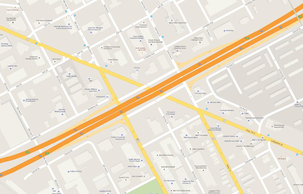
10 Site


11 Southeast corner of the site looking northwest Axon of site plan Northwest side of the site looking south Northeast side of the site looking south

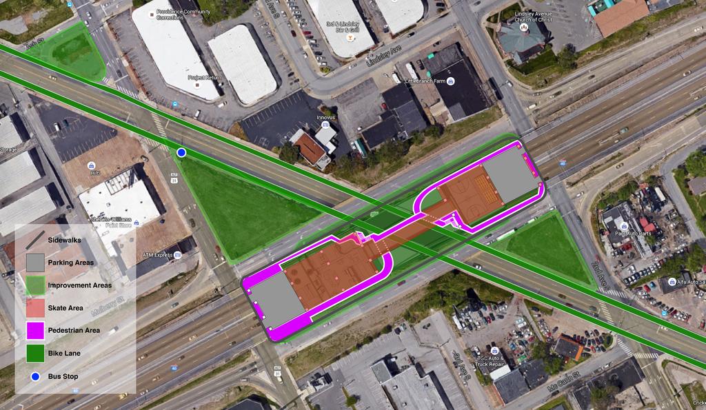
12 The Plan Stairs Basketball Court Parking 4th Ave. S on/off ramp connector bridge on/off ramp connector bridge Parking Skate Park Pedestrian/Skate Bridge Lafayette St 2nd Ave. S

 /")
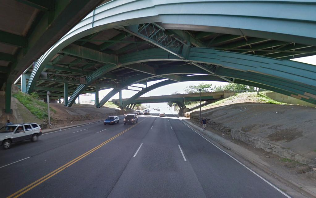
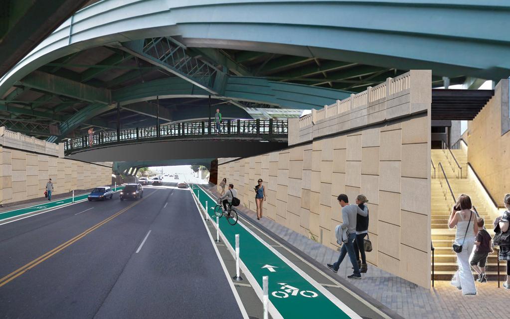
13 Planned skate park Before (top) / After (bottom)
14
15
16 Founded in 2000, the Nashville Civic Design Center is a nonprofit organization whose mission is to elevate the quality of Nashville s built environment and to promote public participation in the creation of a more beautiful and functional city for all. Towards this end, The Nashville Civic Design Center Promotes the Ten Principles of The Plan of Nashville. Educates the public about civic design through: lectures by prominent speakers; presentations on the history and practice of urban design; and continuing education opportunities for design and development professionals Provides professional staff and highly qualified design interns to consult on civic and other community development projects. Facilitates public dialogue about civic design and its impact in Nashville. Researches and publishes reports on various civic design issues.
San Francisco Bay Pilot: Sausal Creek Community Leader Charrette May 11, 2016 Marcus Griswold
 San Francisco Bay Pilot: Sausal Creek Community Leader Charrette May 11, 2016 Marcus Griswold 1 Overview Project Overview Watershed Context Assets and Challenges Opportunities Green Streets Creek Access
RECLAIMING PUBLIC SPACE
 RECLAIMING PUBLIC SPACE INTRODUCTION PRECEDENT STUDIES AREAS OF FOCUS VISION IMPLEMENTATION CHURCH ST WEST END AVEBROADWAY BROADWAY DIVISION ST DEMONBREUN ST Reclaiming Public Space Like most cities, Nashville
Riverwalk Dreams compiled by Thomas P. Healy November 16, 2017
 Riverwalk Dreams compiled by Thomas P. Healy November 16, 2017 1986 Ripple Village Plan: A neighborhood plan developed by the City of Indianapolis Department of Metropolitan Development s Division of Planning
The Emerging Language of Highway Removals
 The Emerging Language of Highway Removals This page intentionally left blank. Introduction The Interstate Highway System, comprised of more than 46,876 miles of highways, provides connections to population
Asheville Design Center March 2010
 Community-Based Design Update Asheville Design Center March 2010 www.ashevilledesigncenter.org 1 introduction contents 1. Introduction 2. Background 3. ovember Design Charrette 4. January Work Session
Parcel 5. Level 1 Application March 12, Design Submittal POST ROAD RESIDENTIAL
 P:\3371 Providence \graphic\meetings and Presentations\2018.03.12_Level 1 Submission/ I-195 Level Redevelopment 1 Design Submission.pdf District Commission Introduction The Level 1 conceptualization of
I-95 Girard Avenue Interchange Near Neighbors Meeting. Project Status
 I-95 Girard Avenue Interchange Project Status Construction is underway for Phase 1 and 2. Phase 3 construction will begin early 2014. Overall Project Area and Schedule GR0: Completed GR0: Completed in
Table of Contents. Elm Avenue Improvement Plan City of Waco, Texas. Introduction 1. Existing Context 1 Figure 1 2.
 Table of Contents Introduction 1 Existing Context 1 Figure 1 2 Plan Guidelines 3 Future Urban Form 4 The West-End 4 Main Street 6 The East-End 7 Figure 2 9 Public Improvement Recommendations 7 General
Bourne Downtown Site Planning
 Prepared for: The Town of Bourne, MA In Cooperation with: Bourne Financial Development Corporation Prepared by:, Inc. June 24, 2009 Table of Contents Introduction and Summary... 1 Site Existing Conditions...
Planning and Design: Applied LID Techniques Redevelopments, Housing, Mixed Use, Infrastructure
 Civil Engineering Landscape Architecture Environmental Restoration Planning Planning and Design: Applied LID Techniques Redevelopments, Housing, Mixed Use, Infrastructure Peg Staeheli, ASLA, LEED AP March
TRANSPORTATION & STREET DESIGN
 TRANSPORTATION & STREET DESIGN Review of Goals Connect neighborhoods to Square Enable access to the river Improve pedestrian environment Reorient road network to local use Three Specific Areas of Intervention
Reclaiming Old West Broad Street: I-16 Ramp Removal Study
 Reclaiming Old West Broad Street: I-16 Ramp Removal Study Community Meeting Summary July 15, 2014 The first community meeting for Phase II of the I-16 Ramp Removal Study was held on July 15, 2014, at the
Description of Preferred Alternative
 Chapter 2 Description of Preferred Alternative 2.1 Introduction This chapter of the programmatic Sammamish Town Center Sub-area Plan Final EIS provides a more detailed description of the Preferred Alternative
7.5 Impacts on the Section 4(f) Properties
 Properties") constructive use, such as noise, air quality and visual impacts were also assessed. It was determined that this project would not introduce changes of an external nature that would affect the recreational
constructive use, such as noise, air quality and visual impacts were also assessed. It was determined that this project would not introduce changes of an external nature that would affect the recreational
Blue Line LRT Extension
 v e Noble Pkwy Noble Pkwy Xerxes Ave N Shingle Creek Penn Ave N Penn Ave N Fremont Ave N Lyndale Ave N S Washington Ave University Ave NE Blue Line LRT Extension LIGHT RAIL PLATFORM AND STATION DESIGN
6-GATEWAYS, WAYFINDING & PUBLIC SIGNS
 6-GATEWAYS, Wayfinding & ublic Signs 6-GATEWAYS, WAYFINDING & UBLIC SIGNS Downtown Georgetown has a strong base of local users as well as seasonal tourists and visitors. Many first-time visitors, and those
Dogpatch/22nd Street Greening
 TEAM MEMBERS Prepared for: GreenTrustSF Central Waterfront www.gtsfcw.org Prepared by: Fletcher Studio San Francisco, CA www.fletcherstudio.com Landscape Architecture Urban Design Environmental Planning
DICKERSON ROAD INVENTORY
 N a s h v i l l e C i v i c D e s i g n C e n t e r DICKERSON ROAD INVENTORY 2006 ACKNOWLEDGEMENTS TABLE OF CONTENTS The work represented in this document was done in conjunction with the Planning Department
PIKE PINE RENAISSANCE: ACT ONE. October 19, 2017
 PIKE PINE RENAISSANCE: ACT ONE October 19, 2017 WATERFRONT SEATTLE PROGRAM PROJECT INTRODUCTION Pike and Pine streets, between First and Melrose avenues Pedestrian and streetscape improvements Budget:
THREADING THE DIAMOND IN DOWNTOWN LOS ANGELES
 THREADING THE DIAMOND IN DOWNTOWN LOS ANGELES Located in the heart of downtown Los Angeles, the existing site is situated in the northern lot of the Los Angeles Civic center; comprised of historic City
PROPOSED IMPROVEMENTS
 IV. PROPOSED IMPROVEMENTS The proposed improvements for each alternative carried forward are discussed below. A. FUNCTIONAL CLASSIFICATION AND ROADWAY CROSS-SECTIONS The classifications of the roadways
Open Space and Recreational Resources
 Chapter 3: Open Space and Recreational Resources A. INTRODUCTION Under the 2012 City Environmental Quality Review (CEQR) Technical Manual guidelines, open space is defined as publicly accessible, publicly
CHAPTER 8 ISSUES, CONCERNS, CONSTRAINTS AND OPPORTUNITIES
 CHAPTER 8 ISSUES, CONCERNS, CONSTRAINTS AND OPPORTUNITIES Introduction This River Conservation Plan was developed during a time of tremendous activity and effort in planning the transformation of the Delaware
North Hollywood - Valley Village Non-Parcel Resources 02/13/13
 Non-Parcel Resources West side Bellaire, north of Burbank Air Raid Siren #121 Institutional - Military Air Raid Siren A/C; 1/3; 1/3 North side of Otsego St., east of Bakman Air Raid Siren #15 Institutional
Existing Transportation System 5-1
 5-1 The Jackson County transportation system is served by several modes of transportation including streets and highways, multi-modal, non-motorized, rail, and aviation. While the focus of the transportation
Corridor Vision. 1Pursue Minnehaha-Hiawatha Community Works Project. Mission of Hennepin County Community Works Program
 1Pursue Minnehaha-Hiawatha Community Works Project Minnehaha-Hiawatha Community Works is a project within the Hennepin Community Works (HCW) program. The mission of the HCW program is to enhance how the
FY Capital Improvement Program Parks and Landscaping. 8 - Summary
 PARK PROJECTS FY 211-215 Capital Improvement Program Description FY 21 FY 211 FY 212 FY 213 FY 214 FY 215 1 Restroom Bldgs (Replace or Construct)-Jefferson, McDonald, 5,774,623 4,669,623 1,15, Allendale,
Sewanee Village + Request for Builder/Developer Proposals
 Sewanee Village + Request for Builder/Developer Proposals Contact: Frank X. Gladu Special Assistant to the Vice Chancellor University of the South 735 University Ave Version 3 Sewanee TN 37383 Released:
Infrastructure, Waterfronts, and the City
 Central Delaware Waterfront Planning Process Best Practices Session Philadelphia, Feb. 3 2007 Infrastructure, Waterfronts, and the City Examples of Large-Scale Infrastructure Changes That Reconnect Previously
IMPLEMENTING CREATIVE PLACEMAKING IN REAL ESTATE ULI Charlotte January 24, 2018 Juanita Hardy, Senior Visiting Fellow for Creative Placemaking
 Replace with image of Charlotte CPM site IMPLEMENTING CREATIVE PLACEMAKING IN REAL ESTATE ULI Charlotte January 24, 2018 Juanita Hardy, Senior Visiting Fellow for Creative Placemaking AGENDA Background
THE NEIGHBORHOOD TODAY
 THE NEIGHBORHOOD TODAY CORE AREA VISION How are we Good Urbanism A Site s DNA thinking about Elements of great Unique elements urban communities embedded in a place the site and design? ELEMENTS LIKE:
Overtown is a district in Miami filled with vacant lots and urban residual spaces
 FIU. Architecture. Sustainable Urbanism. Professor Gray Read. MAA 2015. Selene Varela Overtown is a district in Miami filled with vacant lots and urban residual spaces after the construction of the highways,
1 October Dear Citizens of Charlotte and Mecklenburg County,
 1 October 2011 Dear Citizens of Charlotte and Mecklenburg County, As co-chairs of the Center City 2020 Vision Plan Steering Committee, we are proud to present the Center City 2020 Vision Plan, which sets
Keith L. Coogler P.O. Box 5092 Huntsville, TX (936) (Home), (936) (Work)
 (Home), (936) (Work)") Keith L. Coogler P.O. Box 5092 Huntsville, TX 77342 (936) 291-1034 (Home), (936) 294-1203 (Work) ith_klc@shsu.edu EDUCATION EdD, Higher Education, Curriculum & Instruction, Texas A&M University-Commerce,
Keith L. Coogler P.O. Box 5092 Huntsville, TX 77342 (936) 291-1034 (Home), (936) 294-1203 (Work) ith_klc@shsu.edu EDUCATION EdD, Higher Education, Curriculum & Instruction, Texas A&M University-Commerce,
Long Lost Allies? Walking Advocates & Business District Organizations. Matt Kazinka Lake Street Council. Shaina Brassard Seward Redesign
 Long Lost Allies? Walking Advocates & Business District Organizations Shaina Brassard Seward Redesign Rob Hanson West Broadway Business and Area Coalition Matt Kazinka Lake Street Council Jamie Schumacher
Northwest Rail Corridor and US 36 BRT Development Oriented Transit Analysis 4.4 STATION AREA FINDINGS
 4.4 STATION AREA FINDINGS Each station is different, and each one requires a separate set of recommendations based on the vision for the site. This section outlines an initial TOD strategy and recommendations
Subdivision Design Criteria. Penihana North GUIDELINES TO THE RULES
 Created September 2013 Penihana North Subdivision Design Criteria GUIDELINES TO THE RULES This part of the Plan sets out the design criteria for subdivision in Penihana North. The criteria will be considered
2040 Long Range Transportation Plan
 2040 Long Range Transportation Plan Adopted: April 15, 2013 APPENDIX D HIGHWAY NEEDS PLAN PROJECTS FREDERICKSBURG Existing and Committed Projects Fall Hill Avenue/Mary Washington Blvd. (Fredericksburg)
4.1 Build Alternative 1 Construction Phasing
 SECTION 4 Implementation Plan This section discusses potential segmentation of the build alternatives into multiple projects for implementation of improvements to the NSH from Rabbit Creek Road to 36th
2. reimagine kings way undercroft as a community space
 2. reimagine kings way undercroft as a community space CLARENDON STREET CLARKE STREET QUEENS BRIDGE STREET MORAY STREET CITY ROAD BALSTON STREET BOYD KINGS WAY POWER STREET KAVANAGH WEST GATE FREEWAY Figure
I-84 Hartford Project Open Planning Studio #12. April 25, 2017
 I-84 Hartford Project Open Planning Studio #12 April 25, 2017 Meeting Agenda 1. I-84 Hartford Project alternatives update 2. Multimodal station area planning 3. I-84 / I-91 Interchange Study coordination
Bloor Street East Potential Ravine Portal Overlook and Access Passage to the Rosedale Valley and Don River Valley Ravine, Toronto, Canada
 TRANSFORMATIVE IDEA 2. GREAT STREETS Bloor Street Christie Pits Park Bloor St Spadina Ave Bathurst St Shaw St 1 Recognize the significant public realm improvements along Bloor Street and extend and enhance
Carlsbad Village Redevelopment Concept Summary of Features
 Carlsbad Village Redevelopment Concept Summary of Features Calthorpe Associates November 5, 2003 The Redevelopment Concept illustrates a vision for the future of Carlsbad Village. The overall vision of
RA1.01. Project Description:
 Project Description: Designed around a philosophy of "healthy building for healthy bodies," the University s recreation center inspires personal health and wellness. As the University s campus continues
PILLAR FOUR INTEGRATE LAND USE & TRANSPORTATION
 PILLAR FOUR INTEGRATE LAND USE & TRANSPORTATION 8 Scarborough Centre on the Move Transportation Master Plan 123 8 Transportation Pillar Four Integrate Land Use & The fourth pillar focuses on the relationship
Activities for All Ages. Small Community Feel. Entertainment. Mix of Uses
 DRAFT PROPOSALS Safety Walkability Open Space/Views to Ocean/Beach Access Activities for All Ages Small Community Feel Entertainment Mix of Uses Gathering Place Celebrate Our Assets: Enhance the four major
Equitable Growth Through TOD Planning
 Equitable Growth Through TOD Planning Community Meeting # 2 November 2017 Goals Objectives Extend investment from downtown Connect neighborhoods physically and economically Enhance places based on local
Draft Master Plan for Franklin Park
 Draft Master Plan for Franklin Park Metro Parks Tacoma with SiteWorkshop November 2009 I. overview & background Process & History Master Plan Process The Master Plan is based on a community involvement
TOD IMPLEMENTATION BEST PRACTICE TOOLBOX Leveraging Transit for City Shaping
 arrington.gb@gmail.com gbplacemaking.com THE TOD I LIVE IN ~ PORTLAND, OR TOD IMPLEMENTATION BEST PRACTICE TOOLBOX Leveraging Transit for City Shaping BEST PRACTICE TOPICS Timing & transit Parking & retail
Kenilworth Avenue and Town of Cheverly Industrial Study Briefing
 Kenilworth Avenue and Town of Cheverly Industrial Study Briefing The Maryland-National Capital Park and Planning Commission Prince George s County Planning Department www.pgplanning.org Vanasse Hangen
Cleveland Mall / North Coast Harbor Land Bridge Proposal. "Achieving the Ultimate Goal of Merging the Lakefront with Downtown"
 Cleveland Mall / North Coast Harbor Land Bridge Proposal "Achieving the Ultimate Goal of Merging the Lakefront with Downtown" Document prepared by: Green Ribbon Coalition 2800 Euclid Avenue, Suite 510
Elliot Park 2. Neighborhood Master Plan. Historical Perspective
 Elliot Park 2 Neighborhood Master Plan Historical Perspective August 2002 Early History Development patterns and the growth of Minneapolis largely grew out of the city s historical response to its geography.
Oklahoma and Texas Interdependency Along the I-35 Corridor
 Oklahoma and Texas Interdependency Along the I-35 Corridor Kyle D. Dean, Ph.D Associate Director and Research Economist kyle.dean@okstate.edu Does Oklahoma Need Texas? With increased globalization there
The transportation system in a community is an
 7 TRANSPORTATION The transportation system in a community is an important factor contributing to the quality of life of the residents. Without a sound transportation system to bring both goods and patrons
the west loop HOME TO 5,000 NEW DOGS
 the west loop the west loop HOME TO 5,000 NEW DOGS the west loop HOME TO 5,000 NEW DOGS AND 20,000 NEW RESIDENTS outline: the west loop now the vision how do we get there? opportunity LEVERAGE TRANSIT
WELCOME TO OPEN HOUSE TWO November 28, 2018
 Langstaff Road Weston Road to Highway 7 Class Environmental Assessment Study WELCOME TO OPEN HOUSE TWO November 28, 2018 Please sign in and join our mailing list Study Overview York Region is conducting
CALL TO ARTISTS REQUEST FOR QUALIFICATIONS STart PUBLIC ART PROGRAM
 CALL TO ARTISTS REQUEST FOR QUALIFICATIONS STart PUBLIC ART PROGRAM DOWNTOWN TACOMA GATEWAY ARTWORK Sound Transit s Public Art Program (STart) is seeking an artist or artist team to create a site-responsive
parklets tiny parks with big impacts for city streets SvR Design Sarah Gould 12/21/12
 parklets tiny parks with big impacts for city streets SvR Design Sarah Gould 12/21/12 Not surprisingly, the close connection between people s use of city space, the quality of city space and degree of
Supporting our communities. Bridges
 Supporting our communities Bridges 1,000+ We ve partnered with thousands of owners/clients to inspect, analyze, design, and manage their bridges, providing lasting community connections. We design bridges
THE LEADER IN MANAGED SECURITY
 THE LEADER IN MANAGED SECURITY THE KASTLE DIFFERENCE Through managed security services, protection of your people and your property is handled for you. Managed security is the preferred method for keeping
Bridgeport Comprehensive Waterfront Plan 2 nd Launch Neighborhood Meeting 3/9/16
 CivicMoxie 2016 #WaterfrontBPT @CivicMoxie Bridgeport Comprehensive Waterfront Plan 2 nd Launch Neighborhood Meeting 3/9/16 City of Bridgeport OPED, Department of Planning Bridgeport s greatest asset is
Municipal Heritage Bridges Cultural, Heritage and Archaeological Resources Assessment Checklist Revised April 11, 2014
 Municipal Heritage Bridges Cultural, Heritage and Archaeological Assessment Checklist Revised April 11, 2014 This checklist was prepared in March 2013 by the Municipal Engineers Association to assist with
Downtown District V I S I O N. April 1, 2011 Draft I
 Downtown District V I S I O N April 1, 2011 Draft I Downtown District VISION DRAFT I A project of the Community Design Resource Center at the University of Houston in partnership with the City of Angleton,
Regional Context Statement
 Regional Context Statement REGIONAL CONTEXT STATEMENT 3. REGIONAL CONTEXT STATEMENT In 1995, the Provincial Government passed into law the Growth Strategies Act. The purpose of this provincial initiative
11 GUIDING PRINCIPLES:
 11 GUIDING PRINCIPLES: CATEGORIES FIVE GUIDING PRINCIPLE CATEGORIES The Policy Statement will contain a set of Guiding Principles to inform the urban design and sustainability objectives for the site.
GROUND LEVEL ENLARGEMENT / STREETSCAPE AT PIER AVENUE STRAND & PIER HOTEL HERMOSA BEACH HARDSCAPE MATERIAL KEY MAP PIER AVENUE
 COMPOSITE LANDSCAPE LOT B ( MAX SPACES) WILSHIRE BLVD, SUITE 0 BEVERLY HILLS, CA 0 TH STREET WILSHIRE BLVD, SUITE 0 BEVERLY HILLS, CA 0 BRYANT STREET, SUITE 00 SAN FRANCISCO, CA 0 S. FIGUEROA ST. TH FLOOR
Introduction. Midtown Loop. This project s purpose is to envision and design an urban greenway known as Midtown Loop for the Detroit Midtown area.
 Introduction This project s purpose is to envision and design an urban greenway known as for the Detroit Midtown area. Midtown includes the region s cultural core, historic and new neighborhoods, Wayne
EAST SACRAMENTO COMMUNITY PLAN
 EAST SACRAMENTO COMMUNITY PLAN Part Three : COMMUNITY PLAN AREAS AND SPECIAL STUDY AREAS CONTENTS Community Location...3-ES-3 Community Vision...3-ES-4 Community Profile...3-ES-4 Community Issues...3-ES-5
TOD 101 CREATING LIVABLE COMMUNITIES WITH TRANSIT
 1 CREATING LIVABLE COMMUNITIES WITH TRANSIT What are transit Centered Communities? Benefits of Partnerships to Support and Implement What You Will Learn Portland s Pearl District Your Trainers Today Catherine
The Street Grid. Urban Design Elements
 The Street Grid The street grid of Manhattan has evolved constantly throughout the city s history. Streets added in one century are often unrecognizable in the following, leaving historians with little
LOS ANGELES MISSION COLLEGE MASTER PLAN Master Plan DESIGN & DEVELOPMENT PRINCIPLES
 LOS ANGELES MISSION COLLEGE MASTER PLAN DESIGN & DEVELOPMENT PRINCIPLES 34 Quality Learning Along the Arroyo PROGRAM SUMMARY BY PROJECT The following are program summaries for each of the projects planned
ALLIANT ENERGY CENTER
 DANE COUNTY ALLIANT ENERGY CENTER CAMPUS MASTER PLAN MADISON, WISCONSIN JULY 16 TH, 2018 SUBTITLE AGENDA 01 / Summary of Open House 02 / Revised Master Plan 03 / Committee Discussion 04 / Project Schedule
b r a n c h av e n u e tr a n s it co r r i d o r r e vita lization pl a n a m o d el fo r s u b u r ban retro fit
 b r a n c h av e n u e tr a n s it co r r i d o r r e vita lization pl a n a m o d el fo r s u b u r ban retro fit P R I N C E G EO RG E S CO U NT Y, M D ADO PTED 0 p R O J E C T C AT E G O R Y : U R B
CLIMATE CHANGE. DIALOGUE ON CITIES AND CLIMATE CHANGE World Bank Washington, September 21-23, 2009
 DIALOGUE ON CITIES AND CLIMATE CHANGE CLIMATE CHANGE CITIES IN ACTION World Bank Washington September 21-23, 2009 METROPOLIS Created in 1985, the association brings together major cities and metropolitan
COMPREHENSIVE PLAN & UNIFIED DEVELOPMENT ORDINANCE
 Village of Forsyth COMPREHENSIVE PLAN & UNIFIED DEVELOPMENT ORDINANCE Community Planning #6 Prepared by: Vision Statement We envision the Forsyth Community as one which will continue to maintain a small
[Leveraging & Improving Neighborhood Connections] Area A Riverfront
![[Leveraging & Improving Neighborhood Connections] Area A Riverfront](/thumbs/87/97077022.jpg "[Leveraging & Improving Neighborhood Connections] Area A Riverfront") Community Charrette LINC Dallas [Leveraging & Improving Neighborhood Connections] Area A Riverfront 06.02.12 LINC Workshop Area A PDs 774 and 784 cover the majority of Area A employing a form based code
Community Charrette LINC Dallas [Leveraging & Improving Neighborhood Connections] Area A Riverfront 06.02.12 LINC Workshop Area A PDs 774 and 784 cover the majority of Area A employing a form based code
THE COUTURE AT A GLANCE $122 MILLION TOTAL PROJECT COST 44 STORIES / 700,000 SQUARE FEET PUBLIC PLAZAS, PARK & PEDESTRIAN BRIDGES 302 MARKET RATE
 MILWAUKEE THE COUTURE AT A GLANCE $122 MILLION TOTAL PROJECT COST 44 STORIES / 700,000 SQUARE FEET PUBLIC PLAZAS, PARK & PEDESTRIAN BRIDGES 302 MARKET RATE APARTMENTS 54,893 SQUARE FEET OF DESTINATION
Construction Engineering & Inspection
 Construction Engineering & Inspection Serving Florida for 20 Years CEI Engineering Planning Landscape Architecture Urban Design Construction Engineering & Inspection (CEI) I N T R O D U C T I O N Over
The Value Proposition of New Urban Parks in Small Cities: Exploring Newburgh, New York as a Prototypical Case Study
 The Value Proposition of New Urban Parks in Small Cities: Exploring Newburgh, New York as a Prototypical Case Study By Arianna Koudounas Georgetown MURP December 2015 SAFE HARBORS GREEN Newburgh, NY NOW
5 DESIGN DEVELOPMENT 5.1 ORGANIZATION OF SPACE. Projects, due to their programmatic adversity and complexity, function as small cities.
 5 DESIGN DEVELOPMENT IN THE ARCHITECTURE OF SPATIAL POSSIBILITY, ARCHITECTURE IS USED TO PROVIDE A SPATIAL FRAMEWORK THAT IS CAPABLE OF ABSORBING CHANGE, ACTING AS A HOLDING STRUCTURE TO DEFINE THE PARK
Roosevelt Corridor. R e i n v e s t m e n t P l a n. Public Meeting Gilbert Elementary School May 12, :00 pm
 Roosevelt Corridor R e i n v e s t m e n t P l a n Public Meeting Gilbert Elementary School May 12, 2009 6:00 pm Agenda 6:00 6:10 6:25 6:40 6:55 7:00 Opening Comments Councilwoman Jennifer V. Ramos District
RENOVATION & EXPANSION PROJECT
 RENOVATION & EXPANSION PROJECT October 17, 2018 #OaklandEstuaryPark WHY WE ARE HERE TONIGHT page 2 AGENDA 01 project team & schedule 02 understanding the site 03 estuary park program 04 table sessions
Great Plans for a Great City
 CHAPTER 1 Great Plans for a Great City 1 Figure 1.1 South Michigan Avenue today Figure 1.2 South Michigan Avenue will be one of many higher intensity, mixed-use corridors that will extend out from the
Presentation at 4MRV Working Group. Jeffrey Zeeman Arlington Commission for the Arts
 Presentation at 4MRV Working Group Jeffrey Zeeman Arlington Commission for the Arts Creation of official Arts District along several full blocks of South Four Mile Run Drive Maintain / enhance some compatible
History of the Foundation Buildings and Landscapes
 CORNER HOUSE 1 FOUNDATION HOUSE LONG HOUSE History of the Foundation Buildings and Landscapes The Fourth Corner Foundation s name derives from occupying one corner of the intersection of Windham Four Corners,
Southern Gateway Project and Public Green
 Southern Gateway Project and Public Green Transportation and Trinity River Project Committee May 23, 2016 Purpose of Presentation Provide the history and an overview of the Southern Gateway Project (SGP)
City of Los Angeles Department of Public Works
 City of Los Angeles Department of Public Works Environmental Scoping Meeting for the Proposed Sixth Street Park, Arts, River & Connectivity Improvements (PARC) Project May 3, 2017 1 Agenda Introductions
Repositioning Suburban Corridors: From Souless Strips to Something Better
 Repositioning Suburban Corridors: From Souless Strips to Something Better Moderator: Ed McMahon, Urban Land Institute Presenters: Takis Karatonis, Columbia Pike Revitalization Organization Mike Hallibaugh,
NORTH HARBOR INITIATIVE
 Indiana Harbor, East Chicago, Indiana NORTH HARBOR INITIATIVE Community Reinvestment Public Shoreline Connection Strong Leadership The City of East Chicago and are leading the revitalization of Indiana
Potential Green Infrastructure Strategies May 6, 2015 Workshop
 Potential Green Infrastructure Strategies May 6, 2015 Workshop Background The City of Cortland is developing the Tioughnioga Urban Headwaters Green Infrastructure Action Plan with funding from the National
A P P E N D I X B - O P P O R T U N I T Y S I T E S
 A P P E N D I X B - O P P O R T U N I T Y S I T E S OPPORTUNITY SITES As listed in the Land Use Element, the City has identified 15 Opportunity Sites expected to be the focus of change and revitalization
PROJECT SITE The Proposed Project includes the Allen and Pike Street malls between Delancey and South Streets (see Figure 2C-1).
.") Chapter 2, Section C: A. INTRODUCTION This chapter considers the potential of the proposed Reconstruction of the Allen and Pike Street Malls project to affect the urban design characteristics and visual
Chapter 2, Section C: A. INTRODUCTION This chapter considers the potential of the proposed Reconstruction of the Allen and Pike Street Malls project to affect the urban design characteristics and visual
Figure Example of out door dining in the public right-of-way.
 Section 2 Core Area Goal 2.2.1 To maintain and enhance the character of existing streets in the Downtown Area. Character Figure 2.2.1 Example of out door dining in the public right-of-way. A. Provide street
Long Branch Sector Plan
 June 2012 Long Branch is one of Montgomery County s most affordable, older communities and has served as a gateway community, especially for newly arriving immigrants, since the 1960s. Many within this
Downtown Dubuque...it s a great time.
 Downtown Dubuque...it s a great time. Your timing could not be better to invest in Downtown. With hundreds of millions in public and private investment occurring on the City s downtown waterfront, millions
FROM METRO STATIONS TO GREAT URBAN PLACES
 FROM METRO STATIONS TO GREAT URBAN PLACES New Downtowns for Prince George s County 2016 Rail~Volution Conference San Francisco CA BRIEF HISTORY OF WASHINGTON METRO SYSTEM Washington regional Metro System
MISSION STREETSCAPE PLAN. Neighborhood Commercial Streets handle continuous activity. Neighborhood Commercial STREET ROW: Main Design Treatments
 Neighborhood Commercial STREET ROW: 64-80 Main Design Treatments CORNER reduce crossing distance for pedestrians, create entrances to a residential area and slow cars down. help widen sidewalk allocating
CREATE A VIBRANT MIXED-USE COMMUNITY
 CREATE A VIBRANT MIXED-USE COMMUNITY Land Use Public Realm Plan Built Form Heritage Tell us what you think! Place a sticky note here or leave us a comment form LAND USE The land use framework of this Secondary
ITEM #8. Regional Smart Growth Program. Regional Smart Growth Program. Presentation Overview. Coast Highway Vision and Stategic Plan.
 Regional Smart Growth Program Economic Development Commission What is Smart Growth? Adopted as part of the Regional Comprehensive Plan (RCP) RCP provides vision for region based on Smart Growth and sustainability
ARTICLE XXXIII (O) OJUS URBAN AREA DISTRICT
 OJUS URBAN AREA DISTRICT") Page 1 ARTICLE XXXIII (O) OJUS URBAN AREA DISTRICT Sec. 33-284.99.14 Purpose, intent and applicability. A. The regulations contained in this chapter and Chapter 18A, Landscape Code, Code of Miami-Dade
Page 1 ARTICLE XXXIII (O) OJUS URBAN AREA DISTRICT Sec. 33-284.99.14 Purpose, intent and applicability. A. The regulations contained in this chapter and Chapter 18A, Landscape Code, Code of Miami-Dade