1.0 INTRODUCTION. 1.1 Final EIR Organization
|
|
|
- Felix Bishop
- 6 years ago
- Views:
Transcription
1 .0 INTRODUCTION 0 0. Final EIR Organization This chapter presents background and introductory information for the proposed (proposed Project) and provides a description of the proposed elements. Additionally, this chapter discusses general changes and modifications made to the Draft Environmental Impact Report (EIR), most of which are editorial in nature. Chapter, Responses to Comments, presents information regarding the distribution of, and comments on, the Draft EIR, and the responses to these comments. Chapter presents the modifications to the Draft EIR. Revisions were made to the following chapters and appendices of the Draft EIR: Executive Summary Chapter Introduction Chapter Project Description Section. Aesthetics Section. Air Quality Section. Biological Resources Section. Hazards and Hazardous Materials Section. Land Use and Planning Section. Noise Section. Transportation and Circulation Ground and Marine Section. Utilities Chapter Cumulative Effects Appendix G Risk Analysis of LADWP Marine Tank Farm -
2 0 Additionally, the following appendices were added to the Final EIR to support the EIR analysis: Appendix L Caulerpa Control Protocol (Version.0, February, 00) Appendix M Location of Fish Sampling Stations for Port-wide Biological Baseline Study (To be published) Appendix N Location of Abandoned and Plugged Wells Appendix O Project Water Supply Assessment This Final EIR has been prepared in accordance with the requirements of the California Environmental Quality Act (CEQA) (California Public Resources Code [PRC] 000 et seq.), the State CEQA Guidelines (Title, California Code of Regulations [CCR] 000 et seq.). The Los Angeles Harbor Department (LAHD) is the CEQA lead agency. 0. Proposed Project Overview The proposed Project involves development of a variety of land uses within the three distinct areas of the proposed project site: () the Avalon Development District, which includes Area A within the Wilmington Harbor City Community Plan (CP) area north of Harry Bridges Boulevard and Area B within the proposed Port of Los Angeles Plan (Port Plan) and Port Master Plan (PMP) areas south of Harry Bridges Boulevard; () the Avalon Waterfront District; and () the Waterfront Red Car Line Extension and multi-modal California Coastal Trail (CCT) linkage area. See Section. below for greater detail regarding proposed project elements. 0. Existing Conditions.. Regional Setting The Port is located at the southernmost portion of the City of Los Angeles (City) and comprises miles of waterfront and,00 acres of land and water, with approximately 00 commercial berths. The Port is bounded by the community of San Pedro to the west, the Wilmington community to the north, the Port of Long Beach to the east, and the Pacific Ocean to the south. Figure - shows the regional location of the proposed project area. The Port is an area of mixed uses, supporting various maritime-themed activities. Port operations are predominantly centered on shipping activities, including containerized, break-bulk, dry-bulk, liquid-bulk, auto, and intermodal rail shipping. In addition to the large shipping industry at the Port, there is also a cruise ship industry and a commercial fishing fleet. The Port also accommodates boat repair yards and provides slips for approximately,0 recreational vessels, 0 -
3 0 0 Culver City 0 Los Angeles South Gate 0 0 Downey El Segundo 0 0 Manhattan Beach Gardena Compton Lakewood Torrance Carson K:\PROJECTS\POLA_WILMINGTON\00_0\MAPDOC\ PD \ FIG REGIONAL_LOC. MXD NB (0-0-0) Palos Verdes Estates Rancho Palos Verdes 0 Miles PACIFIC OCEAN Project Location 0 Kern Los Angeles Long Beach Orange San Bernardino Riverside San Diego SOURCE: ESRI Streetmap USA (00) Figure - Regional Location
4 commercial fishing boats, miscellaneous small service crafts, and charter vessels that handle sportfishing and harbor cruises. The Port has retail shops and restaurants, primarily along the west side of the Main Channel. It also has recreation, community, and educational facilities, such as a public swimming beach, Cabrillo Beach Youth Waterfront Sports Center, the Cabrillo Marine Aquarium, and the Los Angeles Maritime Museum. 0.. Proposed Project Setting The proposed project site is generally bounded by Lagoon Avenue to the west, Broad Avenue to the east, C Street to the north, and Slip to the south, where over-water viewing piers and floating docks would be proposed. The site includes the Waterfront Red Car Line and the multi-modal CCT linkages beginning in the west at Swinford Street, moving along Front Street to John S. Gibson Boulevard, and then along Harry Bridges Boulevard until it terminates at Avalon Boulevard in the east (see Figure -) Existing Site Conditions The intersection of Avalon and Harry Bridges Boulevards serves as the gateway to the center of Wilmington s business district (heading north on Avalon Boulevard) and the gateway to the community s waterfront (heading south on Avalon Boulevard). The corridor in this vicinity contains modest one- and two-story commercial and industrial buildings, with many vacant and/or underutilized lots. The Avalon Triangle Park development is proposed on the southeastern corner of the site. The Avalon Development District is composed of industrial commercial buildings and vacant lots along the north side of Harry Bridges Boulevard, between Lagoon and Broad Avenues south of C Street, as well as a single block located south of Harry Bridges Boulevard between Avalon Boulevard and Marine Avenue. Existing industrial structures on privately owned, LAHD-leased, and LAHD-owned lots are scattered throughout this district. The historic,00-square-foot Bekins building is located at North Fries Avenue/ West C Street. Existing businesses located on private parcels from west to east include Wilmington Iron Works at West C Street; Tenzera, Inc., at North Island Avenue; Harpur s Marine Engines at 0 West C Street; Marine Wholesale & WHSE, CO, at 0 North Fries Avenue; Avalon Rafts at and North Avalon Boulevard; LA Bunker Surveyors, Inc, at N. Marine Avenue; Monterey Inn (residential) at North Avalon Boulevard; and Smokey s Cycle Parts at North Avalon Boulevard. Other buildings present in the Avalon Development District, but whose functions are unknown include West C Street, North Fries Avenue, and North Broad Avenue. None of the above privately owned parcels are targeted for modification by the proposed Project with the exception of the historic Bekins buildings, which are planned for rehabilitation in accordance with the Secretary of the Interior s -
5 0 0 0 Guidelines for Rehabilitating Historic Buildings. Figure - illustrates LAHDowned and privately owned property. The Avalon Waterfront District area would include the waterfront promenade area and a Land Bridge with an elevated park. Existing buildings in the waterfront promenade area include the 0,000-square-foot Banning s Landing Community Center built in, the National Polytechnic University (College of Oceaneering) building (which would remain), the 0,0-square-foot Catalina Freight building (which would be demolished), and the,0-square-foot National Polytechnic College of Science Hyperbaric Chamber building and,00-square-foot welding pier immediately south of Water Street (both of which would be demolished). The major land use in the area of the proposed Land Bridge and elevated park is the existing LADWP Marine Tank Farm site, on Lot, a,-square-foot parcel north of Pacific Harbor Rail Line and south of A Street (Figure - illustrates LAHDowned, LAHD-leased, and privately owned property). Structures on this parcel include two operational,-square-foot liquid bulk storage tanks, which hold up to 0,000 barrels (bbl), one of which contains raw gas oil and the other hydrotreated gas oil; a smaller operational 0,000 bbl containing hydro-treated gas oil; and six other ancillary structures, which total,00 square feet. The Marine Tank Farm s liquid bulk storage tanks and ancillary structures are leased and operated by the Valero Corporation. In addition to this large parcel, LADWP owns Lot, a vacant,-square-foot parcel south of the rail line, and Lot, a vacant,- square-foot site immediately north of A Street. All LADWP-owned land mentioned above would be dedicated to park use, and existing buildings and structures would be demolished. The Avalon Triangle Park project site is located on a large, paved vacant lot on the southeast corner of Harry Bridges and Avalon Boulevards. The Avalon Triangle Park development project has been planned and processed separately from the proposed Project, but has been designed to complement the planning and design of the proposed Project. The Avalon Triangle Park site is part of the proposed Project because this site would be within the proposed extension of the Port Plan jurisdictional boundary and would be removed from the Wilmington Harbor City CP jurisdictional boundary. The proposed Project includes a programmatic assessment of the relocation of the LADWP Marine Tank Farm to the offsite Olympic Tank Farm, which currently contains nine existing liquid bulk storage tanks. The land is void of natural vegetation. The two areas large enough to accommodate the Marine Tank Farm storage tanks have previously supported storage tanks. The site is located approximately. miles northeast of the proposed project site, at the southeastern corner of Alameda and Robidoux Streets. -
6 SOURCE: ESRI USA Imagery (00) Alameda St D St C St A St Water St Fries Ave Canal Ave Neptune Ave John S Gibson Blvd 0 Harry Bridges Blvd West Basin Slip East Basin Channel West Basin Container Terminal (China Shipping) Trapac Container Terminal WWL Auto Terminal Pasha Vopac Yusen Container Terminal Los Angeles Harbor Front St Pacific Ave Gaffey St Lagoon Ave Island Ave Fries Ave Marine Ave Avalon Blvd Broad Ave LADWP Harbor Generating Station East Basin Trapac Container Terminal 0 00,000 Feet Legend Turning Basin Proposed Project Boundary South Wilmington Grade Separation (Not part of Project) Red Car Line/CCT Avalon Development District A Avalon Development District B Avalon Triangle Park Avalon Waterfront District Figure - Proposed Project Boundary and Surrounding Area K:\PROJECTS\POLA_WILMINGTON\00_0\MAPDOC\ PD \ FIG PROP_PRJ_BNDY. MXD NB (0-0-0)
 A St Water St Slip Lagoon Ave Fries Ave Broad Ave Avalon Blvd")


7 Harry Bridges Blvd SOURCE: ESRI USA Imagery (00), Port of Los Angeles (00) A St Water St Slip Lagoon Ave Fries Ave Broad Ave Avalon Blvd Island Ave Fries Ave Fries Ave Marine Ave Marine Ave Avalon Blvd Legend Project Site Boundary LAHD Property Leased LAHD Property Vacant Privately-Owned Property LADWP Property Feet Figure - Property Ownership K:\PROJECTS\POLA_WILMINGTON\00_0\MAPDOC\ PD\FIG-_PROP_OWN. MXD NB (--0)
8 Surrounding Uses Although most of the proposed Project is within the existing boundary of the Wilmington Harbor City Community Plan, the majority of the Wilmington community lies north of the propose project. Wilmington covers approximately. square miles and is composed of varied land uses. However, the community land uses that surround the proposed project site are almost exclusively light industrial with a small pocket of heavy commercial. The nearest residential area is within mile of the proposed project site. The Wilmington Industrial Park is located northeast of the proposed project site and is bounded (approximately) by Anaheim Street on the north, Harry Bridges Boulevard on the south, Alameda Street on the east, and Broad Avenue on the west. The industrial park is designated and zoned for light industry use, and is developed with a number of industrial uses, as well as some container and truck storage facilities. Some large areas of land remain vacant and available for development. Directly east of the proposed project site is the -acre Wallenius Wilhelmsen Lines (WWL) Auto Terminal site. WWL deals mainly in vehicle processing and logistics services, and can store up to,000 vehicles on site. An extensive rail yard for loading and unloading auto racks is located on site. WWL customers at this site include Nissan and Infiniti. WWL Auto has been a tenant at the Port since (LAHD 00). The.-acre Vopak site is situated south of WWL Auto Terminal and the proposed Project. The Vopak site stores liquid bulk chemical products in approximately 0 storage tanks with a total holding capacity of 00,000 bbls. Onsite storage includes organic and inorganic chemicals, petroleum, animal fats and vegetable oils, and dry bulk goods. The Vopak site also supports a bulk cement distribution facility with an,000-square-foot warehouse. Immediately west of the proposed project site is the LADWP Harbor Generating Station (HGS). The HGS is located to the west of Fries Avenue at the intersection of Fries Avenue and A Street. In addition, there are five combustion turbines (also known as Peaker Units) associated with the Harbor Generating Station that are located to the east of Fries Avenue. The HGS is owned and operated by LADWP and is located on an. acre site outside the existing jurisdiction of the Port Plan and the PMP. It was originally constructed in the late 0s, with the Peaker Units added in 00, to provide local in-basin generation, voltage and VAR (Volts Ampere Reactive) support, transmission support, southern system security, and emergency support for the LADWP electrical system. The basic power generation activities and corresponding facility areas are power generation units, electrical switching and receiving, and fuel storage tanks. However, the HGS does have diesel fixed generators to provide emergency power. More detail on the HGS is provided in Section. of the Draft EIR. Farther west of the proposed project site is the -acre Trans Pacific (TraPac) Container site, which has post-panamax cranes with 00-foot-gauge and 0-longton main hoist capacity. The terminal features a,000-square-foot maintenance -
9 0 0 0 shop, reefer plugs (wheels), grounded plugs, portable generators that maintain an additional plugs, a wash system for the exterior of containers, a wash system for the interior of containers, 0 transtainers, side-handlers, and toplifts. Shipping lines served by TraPac include Mitsui O.S.K., China Shipping, Norasia, Compañia Sudamericana de Vapores, Zim, Wan Hai, APL, Hyundai Merchant Marine Co., and CMA-CGM. The Los Angeles Board of Harbor Commissioners recently approved the TraPac Container Terminal expansion, located between Berths and. The expansion will allow TraPac to expand cargo handling in an efficient manner from 00,000 twenty-foot equivalent units (TEUs) (baseline year 00) to. million TEUs by 0. It is expected that particulate matter of less than. microns (PM. ) will be reduced by % and nitrogen oxides (NO X ) will drop by % below baseline levels as a result of mitigation measures applied during proposed project operations. By 0, total proposed project emissions of volatile organic compounds (VOCs), NO X, sulfur oxides (SO X ), and particulate matter (PM 0 and PM. ) will be reduced approximately 0%. The health risks associated with the modernized terminal operations will be well below regulatory standards of significance and will reduce the estimated cancer risk associated with terminal operations to below baseline levels in large parts of Wilmington. Much of the proposed project planning is based upon the larger Wilmington Waterfront Master Plan/Development Program (Program), which is described in detail in Section ES.., of the Draft EIR s Executive Summary, Project Planning History and Community Involvement. In addition to the Avalon Development District and the Avalon Waterfront District, the Program encompasses the Harry Bridges Buffer Area project located west of Lagoon Avenue. This area, which lies to the northwest of the proposed project site, is intended to provide an open space buffer and visual screening between the Wilmington community and Port industrial operations. Like the Avalon Triangle Park development project, the construction of the Harry Bridges Buffer Area project is proceeding independently and separate from the proposed Project. 0.. CEQA Baseline Section of the CEQA Guidelines requires EIRs to include a description of the physical environmental conditions in the vicinity of a proposed project that exist at the time of the issuance of the Notice of Preparation (NOP). For some resource areas, such as Aesthetics or Geology, the baseline conditions are defined by what was present at the time the NOP was circulated for review (March 00). Assessment of other resource areas such as Air Quality, Biology, or Water Quality may also include information from prior years in order to provide a more reliable and representative characterization of baseline conditions by accounting for fluctuations at any one point in time. This approach is more conservative because it avoids a snap shot of the existing conditions, which does not always account for temporary fluctuations. A description of the baseline conditions is included in Chapter, Project Description, of the Draft EIR and, when special circumstances are present, details are provided in -
10 0 the respective sections of the Draft EIR s Chapter, Environmental Analysis, prior to the impact analysis. These environmental conditions constitute the baseline physical conditions by which the CEQA lead agency determines whether an impact would be significant. The CEQA baseline represents the setting at a fixed point in time, with no project growth over time, and differs from the No Project Alternative in that the No Project Alternative addresses what is likely to happen at the site over time if it were to be built according to the existing plans and regulations, starting from the existing conditions. In other words, the No Project Alternative allows for more growth at the proposed project site, whereas the baseline conditions would not Proposed Project.. Project Purpose The Port of Los Angeles is specifically recognized in the California Coastal Act of (PRC 0000 et seq.) as a primary economic and coastal resource, essential to the national maritime industry (PRC 00(a)). The State of California granted the tidelands comprising the Port in trust to the City of Los Angeles in by statute commonly referred to as the Los Angeles Tidelands Trust Grant (Chapter, Statutes of, as amended). As trustee of the Port, LAHD operates it in accordance with the Los Angeles City Charter, the Los Angeles Tidelands Trust Grant, the Public Trust Doctrine, and the California Coastal Act. These legal mandates require that LAHD use the Port for the purposes of promoting and accommodating waterborne commerce, navigation, fishery and related purposes. The overall purposes of the proposed Project are to increase public access to the waterfront; improve pedestrian connectivity from Wilmington to the waterfront; allow additional visitor-serving commercial and recreational development at the Waterfront District; improve the local economy and economic sustainability of the community by improving the industrial corridor along Harry Bridges and Avalon Boulevards; and to enhance automobile, truck, and rail transportation within and around the immediate area of the Port. The proposed Project seeks to achieve these goals by improving existing infrastructure and providing new infrastructure facilities, providing waterfront linkages and pedestrian enhancements, developing neighborhood and regional recreational open space, and providing increased development and redevelopment opportunities in the Avalon Development District and Avalon Waterfront District.... CEQA Objectives CEQA Guidelines (Section (b)) require that the project description contain a statement of objectives, including the underlying purpose of the proposed Project. The proposed Project is intended to fulfill the overall project purpose of the LAHD. -
11 0 The proposed project objectives were developed based on the community planning process discussed below in Section... These objectives are to: create a project that will serve as a regional draw and attract visitors to the Wilmington Waterfront; design and construct a waterfront park, promenade, and dock to enhance the connection of the Wilmington community with the waterfront while integrating design elements related to the Port s and Wilmington s past, present, and future; construct an independent project that integrates design elements consistent with other area community development plans to create a unified Los Angeles waterfront through the integration of publicly oriented improvements; enhance the livability and economic viability of the Los Angeles Harbor area, Wilmington community, and surrounding region by promoting sustainable economic development and technologies within the existing commercial Avalon Development District; and integrate environmental measures into design, construction, and operation to create an environmentally responsible project Proposed Project Planning History and Community Involvement The design and function of the Avalon Development District and Avalon Waterfront District (approximately 0 acres combined) were the vision of the -acre Program, which is the result of a planning process involving close collaboration between LAHD staff; a consultant team of planners, designers, engineers, economists, public outreach consultants, and other specialists; as well as the Wilmington Waterfront Development Subcommittee of the PCAC, a planning group recognized by the Harbor Board of Commissioners and composed of community representatives and the general public. The following steps were taken in developing the Program:. Starting with and building upon the Wilmington Waterfront Development Final Plan, a conceptual vision plan for the area was prepared in 00 (SMWM), with the participation of the Wilmington Waterfront Development Subcommittee and approval of the Harbor Board of Commissioners.. A visionary master plan was crafted based upon a good understanding of baseline conditions in the proposed project area, including the physical, regulatory, environmental, land use, transportation, historical, cultural, market characteristics, and existing plans and projects.. Improvements, including public art and street furnishings, were considered in nearby San Pedro to bring consistency in quality and character to Port-wide public improvements. -
12 Master Plan alternatives were developed and evaluated for the Wilmington area based on site characteristics and established goals and objectives identified early in the planning process.. Four community workshops were conducted in 00 at critical milestones to garner community input, review, and comment; more than,000 people attended the final meeting on December, 00. In addition, the following guiding principles were identified for the proposed Project through a series of community workshops and meetings: Enhance the livability of the Wilmington community Enhance the economic viability of the Wilmington community by promoting sustainable economic development and technologies Establish a world-class design with a regional draw for the Wilmington waterfront area by enhancing Wilmington s image while maintaining its identity and attracting visitors to the waterfront Create an environmentally responsible project Celebrate the Port and Wilmington s significance past, present, and future Create a unified Los Angeles waterfront through the integration of publicly oriented improvements, from Leeward Bay Marina to the breakwater Promote a sense of ownership in the proposed Project and its results by engaging the whole of the community throughout the planning and design process and by creating opportunities for residents and school children to contribute to the design through program specifications, public art programs, and other elements The Wilmington Waterfront Master Plan and Development Program is the guiding planning document for several separate components that would be designed in harmony with one another in order to promote connectivity, continuity, and improved functionality. Elements covered in the Program include the proposed Project, which is made up of the Avalon Development District (referred to as the Industrial District/Avalon Corridor in the development program), most of the Avalon Waterfront District (Avalon Triangle Park is a separate development project), and the Harry Bridges Buffer Area, which is part of the TraPac container terminal expansion project. While the proposed Project is intended to connect the Wilmington community with the waterfront as well as enhance industrial and commercial land uses and economic viability, the purpose of the Harry Bridges Buffer Area is to separate the residential land uses within the Wilmington community from the industrial land uses of the Port. The recent approval of the Harry Bridges Buffer Area and its future implementation, development of Avalon Triangle Park, and the proposed Project would all proceed separately, and any one project would be implemented and would sustain itself without the implementation of the others. -
13 0 0.. Proposed Project Elements The proposed Project is composed of several actions or elements spread over approximately acres. Development under the proposed Project would occur in the following three areas: Avalon Development District (Areas A and B); Avalon Waterfront District; and Waterfront Red Car Line/Multi-Modal California Coastal Trail In each of these three areas sustainable design elements and features are proposed to help reduce energy and water requirements and to contribute to an improved project design. Jurisdictional boundary adjustments are proposed for the Port Element of the City s General Plan, the Wilmington Harbor City Community Plan (WHC CP), and the Port Master Plan. The redesignation of land uses and rezoning within the proposed project area would also occur under the proposed Project within the three areas identified above. The proposed Project would be constructed and implemented in two phases. The first Phase I: Interim Plan would occur between 00 and 0; the second Phase II: Full Buildout Plan would occur between 0 and 00. Section., Phasing and Demolition and Construction Plan, in the Draft EIR provides additional details regarding the proposed project phasing. The proposed project actions or elements within the three major areas of development are described in greater detail below. Figure - shows an overview of the elements included in the proposed Project. Table - below provides a summary of the three major areas of development by each action or element, the existing uses, and the phase in which each action or element would occur. Figure - illustrates the completed proposed Project using a simulated view. Table -. Elements of the Proposed Project Elements Existing Conditions (CEQA Baseline) Proposed Project Phase I (00 0) Proposed Project Phase II (0 00) AVALON DEVELOPMENT DISTRICT Light Industrial Development Police trailer at southeast corner of C Street and Marine Avenue, vacant industrial lots owned by Port north of Harry Bridges Boulevard, Trade School located at corner of Lagoon and C Street; scattered private buildings Could include the construction and operation of a maximum of,000 sf of light industrial development (oriented toward green technology businesses) around Avalon Boulevard, in the industrial area between Lagoon and Broad Avenues, north of Harry Bridges Boulevard Potentially construct and operate an additional,000 sf of light industrial development (oriented toward green technology businesses). -0
14 Elements Existing Conditions (CEQA Baseline) Proposed Project Phase I (00 0) Proposed Project Phase II (0 00) and south of C Street as currently zoned in Area A; trade school and private buildings to remain unchanged Commercial Development Dockside Ship & Machine Repair structures totaling approximately 0,000 sf and an underutilized,00 sf structure south of Harry Bridges Boulevard between Avalon Boulevard and Marine Avenue and vacant industrial lots Construction and operation of,000 sf of retail/commercial development south of Harry Bridges Boulevard along Avalon Boulevard Waterfront Red Car Museum Bekins Storage Property at Fries Avenue/ West C Street; the Bekins Storage Property is a collection of potentially historic buildings and warehouse structures built in, including a,00 sf building Adaptive reuse of the,00-sf building located on Bekins Storage Property as Waterfront Red Car Museum consistent with the Secretary of the Interior s Guidelines for Rehabilitating Historic Buildings Railroad Green Vacant railroad right of way and lot Construction and operation of approximately acre passive recreation park crossing diagonally from Harry Bridges Boulevard (at Island Avenue) to C Street (east of Fries Avenue) Vacate Avalon Boulevard Avalon Boulevard and associated infrastructure (i.e., curbs, gutters, etc.), vacant industrial lots and industrial buildings listed under Commercial development above Vacation of Avalon Boulevard south of A Street Realign Broad Avenue Broad Avenue and associated infrastructure (i.e., curbs, gutters, etc.) and a corner of a lot used for material storage Realignment of Broad Avenue to continue to the waterfront Streetscape Improvements Existing infrastructure and streets in the Avalon Development District which include Harry Bridges and Avalon Boulevards, C Street, Streetscape and pedestrian enhancements to improve aesthetics and connectivity throughout the Avalon Development District Streetscape and pedestrian enhancements to improve aesthetics and connectivity throughout the Avalon Development District -
15 Elements Existing Conditions (CEQA Baseline) Proposed Project Phase I (00 0) Proposed Project Phase II (0 00) and Broad, Lagoon, Marine, Island, and Fries Avenues Demolition Demolish Dockside Ship & Machine Repair Structures Approximately 0,000 sf (also listed above in Commercial Development) Demolish all structures Demolish Underutilized Structure at N. Avalon Boulevard Approximately,00 sf Demolish structure AVALON WATERFRONT DISTRICT Waterfront Promenade & Replacing Existing Bulkhead Catalina Freight, existing bulkhead and pier Construction and operation of waterfront promenade with landscaping which includes,0 sf of new viewing piers (, concrete pilings, inches in diameter), replacement of approximately,0 sf of existing piers ( concrete piles), and two floating docks measuring,0 sf for visiting vessels Land Bridge with Elevated Park (total 0 acres) LADWP Marine Tank Site Construction and operation of large section ( acres of recreational space) of the Land Bridge extending from the waterfront to the LADWP tanks over the existing rail lines and the realigned Water Street Completion of remaining section of the remaining -acre Land Bridge to total 0 acres; sloped open lawn, ornamental gardens, and terraces with decomposed granite would landscape this portion of the Land Bridge Pedestrian Water Bridge LADWP Marine Tank Site Construction and operation of the pedestrian Water Bridge from Entry Plaza to the waterfront promenade and Observation Tower. Entry Plaza Vacant industrial lot Construction and operation of -acre Entry Plaza located at the southeast corner of Harry Bridges and Avalon Boulevards adjacent to Avalon Triangle Park -
16 Elements Observation Tower Restaurant Development Realignment of Water Street Landscaping Improvements Passenger Drop Demolition Demolish Catalina Freight Demolish National Polytechnic College of Science Hyperbaric Chamber Building Demolish National Polytechnic College of Science Welding Pier LADWP Marine Tank Site Relocation Existing Conditions (CEQA Baseline) Catalina Freight parking and Water Street Catalina Freight and existing bulkhead and pier Existing Water Street and infrastructure (i.e., curb, gutter, etc.) Existing College of Oceaneering parking lot Existing Broad Street and infrastructure (i.e., curb, gutter, etc.) Existing 0,0 sf of Catalina Freight Existing,0 sf of National Polytechnic College of Science Hyperbaric Chamber Building Existing,00 sf of National Polytechnic College of Science Welding Pier Three LADWP bulk storage tanks leased by Valero and associated infrastructure (i.e.,,00 sf of building and subterranean pipelines) Proposed Project Phase I (00 0) Construction and operation of 00-foot-tall Observation Tower with a,-sf footprint and a pedestrian ramp. Realign Water Street Landscaping improvements to the existing College of Oceaneering parking lot and area surroundings Construction and operation of a passenger drop-off east of Banning s Landing Community Center along Broad Avenue Demolish entire building Demolish entire building Demolish entire building Acquisition and demolition of all tanks and associated infrastructure Proposed Project Phase II (0 00) Construction and operation of,000 sf of restaurant development at the waterfront LADWP Bulk LADWP Marine Tank Site After the LADWP tanks -
17 Elements Existing Conditions (CEQA Baseline) Proposed Project Phase I (00 0) Proposed Project Phase II (0 00) Storage Tank Capacity to Olympic Tank Site are demolished a potential feasible relocation of the reduction of bulk storage capacity due to the demolition of the LADWP tanks is the Olympic Tank Site. Dockside Ship & Machine Repair to and N. Marine Avenue Parking Dockside Ship & Machine Repair and an unknown, underutilized structure Prior to the realignment of Avalon Boulevard and construction of,000 sf of commercial, the Dockside Ship & Machine Repair and an unknown underutilized structure would be removed and possibly relocated to and N. Marine Avenue Fries Avenue LADWP Marine Tank Farm Construction and operation of spaces off of Fries Avenue North of Banning s Landing Existing Water Street and infrastructure (i.e., curb, gutter, etc) and portions of a vacant LADWP-owned lot Construction and operation of spaces north of Banning s Landing under the pedestrian water bridge West of Land Bridge, East of Peaker Plants LADWP Marine Tank Site Construction and operation of a landscaped -space surface parking area with landscaping accessible from A Street adjacent to the Land Bridge WATERFRONT RED CAR LINE AND CALIFORNIA COASTAL TRAIL Extension of Waterfront Red Car Line Existing streets and associated infrastructure (i.e., curb, gutter, etc.) Construction and operation of the Waterfront Red Car Line, which would begin at the intersection of Swinford Street and Harbor Boulevard, proceed along Front Street onto John S. Gibson, and then onto Harry Bridges Boulevard where it would terminate at the intersection with Avalon Boulevard (exact alignment is unknown at this time) California Coastal Trail (CCT) Existing sidewalks, streets, and associated infrastructure (i.e., curb, gutter, etc.) The CCT would follow the existing public right-of-way from the intersection of Swinford Street and Harbor Boulevard, proceed along -
18 Elements Existing Conditions (CEQA Baseline) Proposed Project Phase I (00 0) Proposed Project Phase II (0 00) Front Street onto John S. Gibson, and then onto Harry Bridges Boulevard where it would terminate at the intersection with Avalon Boulevard Avalon Development District (Areas A and B) The Avalon Development District is an industrial area located in south Wilmington. The Avalon Boulevard commercial corridor, which bisects the Avalon Development District, is the primary commercial corridor in Wilmington, with the center of town located around the intersection of Avalon Boulevard and Anaheim Street about ½ mile from Harry Bridges Boulevard. Avalon Boulevard currently terminates in the proposed project area at the water s edge. The Avalon Development District includes approximately. acres and has been divided into two areas, A and B, defined by the proposed boundary change of the Port and Wilmington Harbor City Community Plan areas. The elements or actions associated with the Avalon Development District primarily include the following: Area A (within the Wilmington Harbor City Community Plan Area) Light Industrial Development programmatic assessment of infrastructure improvements (including stormwater improvements, dry utility lines, potable waterlines, and wastewater lines) to support up to 0,000 square feet of light industrial development, consistent with current zoning, generally located between Broad Avenue (east) and Lagoon Avenue (west), C Street (north) and Harry Bridges Boulevard (south). Park Development a -acre passive park located on the vacant Railroad Green located between Island and Fries Avenues. Waterfront Red Car Museum adaptive reuse of the historic,00-squarefoot Bekins Storage property located at Fries Avenue/ West C Street for a Waterfront Red Car Museum. Pedestrian Enhancements sidewalk and pedestrian-oriented enhancements along Lagoon, Island, Fries, and Marine Avenues, Harry Bridges and Avalon Boulevards, and C Street. Area B (within the proposed Port Plan and Port Master Plan areas) Commercial Development development of up to,000 square feet of maritime visitor-serving commercial uses, such as an open air Mercado, south of Harry Bridges Boulevard, east of Marine Avenue, west of Avalon Boulevard, and north of A Street. -
19 Street Realignments and Enhancements realignment and improvement of Avalon Boulevard and Broad Avenue (also part of the Avalon Waterfront District) Industrial and Commercial Land Uses Development proposed around Avalon Boulevard, in the industrial area between Lagoon and Broad Avenues, north of Harry Bridges Boulevard and south of C Street, which is referred to as Area A to denote that it would remain under the jurisdictional boundary of the Wilmington Harbor City Community Plan, would build upon the area s existing character, providing opportunities for in-fill development of light industrial uses. The proposed Project would provide pedestrian amenities such as enhanced sidewalks and street trees along Island, Fries, and Marine Avenues, Avalon and Harry Bridges Boulevards, and C Street. Infrastructure improvements would be completed to allow for up to 0,000 square feet of light industrial uses over the next years with a buildout year of 00. In addition to the infrastructure improvements within the industrial areas, the proposed Project would develop up to,000 square feet of commercial development, such as a pedestrian-oriented Mercado, one block south of Harry Bridges Boulevard between Avalon Boulevard and Marine Avenue in the location denoted as Area B due to its proposed incorporation into the Port Plan and PMP boundary areas, both of which would expand north to Harry Bridges Boulevard. Nearly all development within the Avalon Development District would occur on vacant land. Site clearing, demolition of paved sites, and rough grading would be required. Except for a few parcels (as detailed below), privately owned parcels and buildings would not be modified. Most of these existing uses would see streetscape improvements and pedestrian enhancements that may temporarily affect individual building accessibility due to construction activities. Figure - illustrates typical pedestrian improvements throughout the Avalon Development District. In a few cases, existing privately owned parcels in the Avalon Development District and in small portions of the Avalon Waterfront District would need to be acquired by LAHD in order to implement the proposed realignment of Avalon Boulevard. Parcels that would be subject to acquisition, either through negotiations, which may include the exchange of land within the Avalon Development District or if necessary through eminent domain, would include parcels located at,,, and North Avalon Boulevard. Table - lists parcels that would be acquired in the Avalon Development District Area B, while Figure - illustrates all parcels that would be acquired in the Avalon Development District Area B as well as in the Avalon Waterfront District. -
20 SOURCE: Sasaki (00) Figure - Proposed Project Boundary by Separate Areas
")
21 Figure - Proposed Project Rendering SOURCE: Sasaki(00) K:\PROJECTS\POLA_WILMINGTON\00_0\MAPDOC\ FIG_PD--_Concept_rend. AI NB (0-0-0)
 K:\PROJECTS\POLA_WILMINGTON\00_0\MAPDOC\ FIG_PD_-_AvalonDD.")
22 Figure - Avalon Development District: Street Enhancements SOURCE: Sasaki(00) K:\PROJECTS\POLA_WILMINGTON\00_0\MAPDOC\ FIG_PD_-_AvalonDD. AI NB (0-0-0)
23 Lagoon Ave Island Ave Fries Ave Harry Bridges Blvd Harry Bridges Blvd Marine Ave Broad Ave A St Avalon Blvd K:\PROJECTS\POLA_WILMINGTON\00_0\MAPDOC\ PD\FIG-_PROP_ACQ. MXD NB (0-0-0) Legend Project Site Boundary Parcel Boundaries. Industrial Building. Marine Technical Services-Dockside Machine & Ship Repair. Marine Technical Services-Dockside Machine & Ship Repair. Marine Technical Services-Dockside Machine & Ship Repair. LADWP Property-Vacant. Vacant. Vacant. LADWP Property-Vacant. Vacant 0. LADWP Marine Tank Farm. LADWP Marine Tank Farm. Catalina Freight Building. National Polytechnic College of Science Hyperbaric Chamber Building. National Polytechnic College of Science Welding Pier Fries Ave 0 Water St Feet SOURCE: ESRI USA Imagery (00) Figure - Property to be Acquired for the Proposed Project
24 Table -. Parcels located within Avalon Development District (Area B) to be Acquired and Structures Removed Figure - # Address or APN North Avalon Boulevard North Avalon Boulevard North Avalon Boulevard North Avalon Boulevard Lot (LADWP) Square Footage (Lot/Bldg),0 /,,0 /,0,0 /,, /,000, / None, /, /,00 (est) / Existing Use or Business Name Industrial building Dockside Machine & Ship Repair Dockside Machine & Ship Repair Dockside Machine & Ship Repair Vacant Vacant O Donall Oil, LLC Vacant Norma J. Hanson, TR Vacant LADWP Potential Relocation Site - No Existing Use and North Marine Avenue and North Marine Avenue and North Marine Avenue - No Existing Use - No Existing Use - No Existing Use - No Existing Use Potentially Historic Note: Potential historic resources are discussed in Chapter., Cultural Resources, of the Draft EIR. Source: LAHD 00.. No No No No No No No No Purpose of Removal Realignment of Avalon Boulevard Realignment of Avalon Boulevard Realignment of Avalon Boulevard Realignment of Avalon Boulevard Realignment of Avalon Boulevard Commercial Commercial Commercial... Railroad Green Park A passive open space would be built within an existing abandoned railroad right-ofway. This approximately -acre Railroad Green would cross the area diagonally and provide public access, seating, and passive recreation opportunities. Landscaping and open lawn would be installed. Figure - provides a conceptual rendering of the proposed park. -
25 ... Waterfront Red Car Museum A Waterfront Red Car Museum would be located one block north of the proposed Waterfront Red Car alignment at the Bekins Storage Property at Fries Avenue/ West C Street. The Bekins Storage Property is a collection of potentially historic buildings and warehouse structures built in. These structures, including a,00-square-foot building, would be adaptively reused to house the Waterfront Red Car Museum. Rehabilitation would be conducted in accordance with the Secretary of the Interior s Guidelines to Rehabilitating Historic Buildings Traffic Improvements To improve area traffic circulation, while enhancing pedestrian safety and appeal, selected streets are proposed for improvements. A portion of Avalon Boulevard, south of A Street, would be downgraded and then vacated to prioritize pedestrian use and activity at the,000-square-foot commercial parcel, while Broad Street would be realigned to provide vehicular traffic a dedicated route to the waterfront. Table - above lists parcels in the Avalon Development District that would be acquired for the realignment. Because the realignment also takes place within the Avalon Waterfront District, more information is provided in Section... below. In addition, an improvement to connect Harry Bridges Boulevard near Lagoon Avenue to Pier A Street would be built during construction of the proposed Project. This improvement, known as the South Wilmington Grade Separation, is a separate project and has been previously assessed under CEQA. It would consist of an elevated road extending from Harry Bridges Boulevard, passing over the existing railroad tracks, and connecting to Pier A Street and Fries Avenue. Once complete, it would allow better access to the proposed project area and nearby industrial sites, and would also reroute some of the truck traffic currently using Harry Bridges Boulevard Avalon Waterfront District The Avalon Waterfront District is composed of the following elements: Waterfront Promenade adding pedestrian-oriented features and improvements such as a waterfront promenade with viewing piers and,000 square feet of restaurant/visitor-serving retail development, a 00-foot Observation Tower with a pedestrian ramp, removing the Los Angeles Department of Water and Power (LADWP) Marine Tank site and associated pipe conveyance infrastructure, and remediating the site; this area is generally defined by the current Water Street alignment and the National Polytechnic University (College of Oceaneering) to the north, Fries Avenue to the west, and the current Avalon Boulevard alignment to the east. The Port harbor and views of the water at Slip are along its southern border. -

26 Figure - -Acre Railroad Green Park SOURCE: Sasaki(00) K:\PROJECTS\POLA_WILMINGTON\00_0\MAPDOC\ FIG_PD RR_GREENPARK. AI NB (0-0-0)
27 0 0 Land Bridge and Elevated Park a 0-acre Land Bridge with an elevated park and a pedestrian water bridge enhanced by an integrated water feature that would provide the surrounding community with open space and improved pedestrian access to the waterfront. This area is generally bounded by A Street to the north, Avalon Boulevard to the east, the Harbor Generating Station and its associated peaker unit to the west, with the Harbor Rail Line and Slip No. to the south. Avalon Triangle Park located south of Harry Bridges Boulevard, between Broad Avenue and Avalon Boulevard. Avalon Triangle Park is not part of the proposed Project, but it would be included within the area that would be encompassed by the proposed Port Plan and PMP boundary expansion. Avalon Boulevard, Broad Avenue, and Water Street Realignment downgrade and vacate Avalon Boulevard south of A Street, realign Broad Avenue to the waterfront, and realign Water Street to run adjacent to the Pacific Harbor Rail Line, which is proposed to travel under the proposed Land Bridge to improve pedestrian circulation and provide space for the waterfront promenade. The elements or actions associated with the Avalon Waterfront District primarily include the development of a waterfront promenade, including visitor-serving amenities such as commercial development and an observation tower; the development of a Land Bridge with open space and an elevated park; and an Entry Plaza and pedestrian water bridge connecting Harry Bridges Boulevard to the waterfront promenade. The existing LADWP Marine Tank site in the area would be demolished, and surface parking and traffic improvements are proposed Waterfront Promenade and Visitor-Serving Amenities The waterfront promenade would be the central public amenity of the Avalon Waterfront District, and would be anchored by visitor-serving development and recreational attractions along the waterfront. A -acre outdoor plaza designed for gatherings and events would be constructed at the location of the existing Banning s Landing Community Center parking area, which would be relocated north, under the pedestrian water bridge. Restaurant and visitor-serving retail uses totaling,000 square feet would be incorporated into the waterfront boardwalk in Phase II. Due to the presence of train noise, all commercial structures located at the waterfront (e.g., the,000-square-foot restaurant and visitor-serving retail) that would incorporate exterior uses (e.g., outside seating for restaurants) would be located more than 00 feet from the heavily used San Pedro Branch Line and TraPac intermodal container terminal facility (ICTF) lead. In addition, all commercial structures would be designed to shield any exterior uses from the existing rail line by either locating the building between the exterior use and the rail line or by using sound-attenuating barriers (i.e., clear Plexiglas) at any locations that have direct line of sight to the existing rail lines east of Fries Avenue and along realigned Water Street. The waterfront promenade would incorporate approximately,0 square feet of new over-the-water viewing piers and two floating docks with a combined size of -
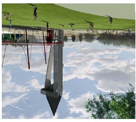
28 0 0,0 square feet. These piers and floating docks would require approximately 0 concrete piles for support, while the replacement of approximately,0 square feet of existing viewing piers would require approximately concrete piles. The public floating docks would accommodate up to nine vessels. Assuming boats would dock for up to hours and assuming slips would not remain vacant for more than a brief period, it was conservatively estimated that the floating docks would support up to boat trips a day. At a future date, it is possible a water taxi program, similar to the Long Beach program but smaller in scale, would be proposed to travel between the proposed Project and San Pedro. Figure - provides a photosimulation of the proposed waterfront with the Observation Tower in the background. At the water s edge, the proposed Project would modify the existing bulkhead wall through a combination of concrete soil mixing and steel sheet pilings, including replacing a 0-foot length of the existing bulkhead at the head of Slip. The existing concrete bulkhead wall would remain in place, and on the east and west sides of the area designated for soil mixing, a new steel sheet pile wall would be installed immediately waterward from the existing wall. This action would fill,00 square feet of Slip. Figure -0a shows the top view of the area proposed for soil mixing and for steel sheet pilings, while Figure -0b provides a cross-section. Other waterfront promenade amenities could include a water feature, shade structures, signage, landscaping, and public art. Observation Tower The Observation Tower would be an area landmark, visible from the nearby Port businesses and the communities of Wilmington and San Pedro. It would incorporate a tall, vertical architectural element that would mimic a sail. The tower would be illuminated at night with accent lighting until midnight, similar to the Vincent Thomas Bridge. Figure - provides an architectural schematic of the Observation Tower Land Bridge and LADWP Marine Tank Site LADWP owns the Marine Tank Farm just north of Banning s Landing between Fries Avenue and Avalon Boulevard, north of Water Street and south of A Street, which it leases to the Valero Energy Corporation. Two large liquid bulk storage tanks and a third smaller tank constrain public access to the water s edge. Beginning in 0, the property would be dedicated for recreational use, and the liquid bulk tanks and associated structures would be removed. Any potential soil and/or groundwater contamination would be remediated pursuant to Department of Toxic Substances Control (DTSC), Regional Water Quality Control Board (RWQCB), or other oversight agency standards. As mentioned above and listed in Table - below, several existing structures associated with the LADWP site would be demolished, including the two 0,000 bbls oil storage tanks, the smaller 0,000-0

29 Figure - Proposed Waterfront SOURCE: Sasaki(00) K:\PROJECTS\POLA_WILMINGTON\00_0\MAPDOC\ FIG_PD PROPD_WF. AI NB (0-0-0)
30 Sheetpile* L = 0± Soil Improvements Sheetpile L = 00± EAST WEST N Fill (for sheetpile): From 0% design assume ' from bulkhead wall to sheetpile A F = 000 sf East A F = 00 sf West * Grade raised approximately ' using lightweight backfill in this area SOURCE: Sasaki (00) Figure -0a Proposed Bulkhead Wall Design

31 SOURCE: Sasaki(00) Figure -0b Proposed Bulk Head Wall Cross-Section K:\PROJECTS\POLA_WILMINGTON\00_0\MAPDOC\ FIG_ES_0_PROPD_BulkHead. AI NB (0-0-0)
 K:\PROJECTS\POLA_WILMINGTON\00_0\MAPDOC\ FIG_PD CD_PROP_OT.")
32 Figure - Conceptal Design of the Proposed Observation Tower SOURCE: Sasaki(00) K:\PROJECTS\POLA_WILMINGTON\00_0\MAPDOC\ FIG_PD CD_PROP_OT. AI NB (0-0-0)
33 0 bbls tank, and six other structures, totaling,00 square feet. Figure - illustrates all parcels that would be acquired in the Avalon Development District and Avalon Waterfront District. LADWP would have an opportunity to rebuild similar tanks with similar capacities at an offsite location as yet to be determined. One potentially feasible site would be the Olympic Tank Farm site. miles northeast of the proposed Project site on the southeastern corner of Alameda and Robidoux Streets. Figure - shows the Olympic Tank Farm site in relation to the proposed project. The Olympic Tank Farm is characterized by nine existing liquid bulk storage tanks. As illustrated in the figure, the land is void of natural vegetation. The two areas large enough to accommodate the Marine Tank Farm storage tanks have previously supported storage tanks. Table -. Parcels Located in the Avalon Waterfront District to be Acquired or Dedicated for Use of the Land Bridge and Structures to be Removed Figure - # Address or APN Square Footage (Lot/Bldg) Existing Use or Business Name Potential Relocation Site Potentially Historic Purpose of Removal Northwest corner of Parcel / Northwest corner of ,000 (est) / None Scrap Material Storage No Realignment of Broad Avenue 0 Lot (LADWP ) / Northeast portion of 0-00-, /,00 (bldgs) and,000 (Oil Tanks) (est) Marine Tank Farm Alameda and Robidoux Streets, Los Angeles (Olympic site) No Phase II Land Bridge Lot (LADWP) / East-central portion of 0-00-, / None Vacant No Phase I Land Bridge 00 W. Water Street Southeast portion of ,00 / 0,0 Catalina Freight Building (Warehouse and Office) 0 South Pier A Street No Relocating for Business Reasons/Land Bridge and Waterfront Promenade North edge of Slip Southeast portion of Unknown /,0 National Polytechnic College of Science Hyperbaric Chamber Relocation is not planned No Waterfront Promenade -
34 North edge of Slip Southeast portion of Unknown /,00 building National Polytechnic College of Science welding pier Relocation is not planned Note: Potential historic resources are discussed in Chapter., Cultural Resources, of the Draft EIR. Source: LAHD 00 No Waterfront Promenade Prior to the removal of the Marine Tank Farm storage tanks and ancillary buildings, a major section of the proposed 0-acre Land Bridge would be constructed and operated under the Phase I: Interim Plan. The upper promenade, with a plaza and a large water feature using recycled water, would be located immediately over the railroad and Water Street crossing. It would consist of the southern portion of the future large elevated park, including terraced seating for public gatherings. Directly west of the Land Bridge, a planting screen would buffer the Land Bridge from the LADWP peaker power units to the west, which would continue to operate during construction and operation of the proposed Project. This interim Land Bridge would include an interim pedestrian water bridge to the east of the LADWP Marine Tank Farm, connecting the landscaped Entry Plaza to the waterfront. The pedestrian water bridge would provide unimpeded pedestrian and bicycle access to the waterfront. The pedestrian bridge is referred to as a water bridge because of the architect-designed water feature that would run its length. Figure - provides an architectural rendering of the pedestrian water bridge, while Figure - shows a cross-section of the bridge. It would consist of a steel structure with a linear water feature integrated into its outside edge, and would link the -acre Entry Plaza, located at the southeast corner of Avalon and Harry Bridges Boulevards, to the waterfront promenade. During Phase II: Full Buildout, beginning in approximately 0, the proposed Project would begin construction of the Land Bridge on the then decommissioned LADWP Marine Tank Farm site. This phase of construction would finish the Land Bridge and 0-acre elevated park. Sloped open lawn, ornamental gardens, and terraces with decomposed granite would landscape this portion of the Land Bridge. Shade pavilions with solar panels would be included within the Land Bridge, in addition to the waterfront promenade area, with a goal of providing up to.% of the total proposed Project s operational energy needs. A -space surface parking area with landscaping would be accessible from A Street and located adjacent to the bridge and the operating LADWP peaker units. When completed, the Land Bridge and adjacent pedestrian water bridge would connect the Wilmington community and the waterfront promenade via the -acre Entry Plaza. Figure -a provides an elevation of the Phase II Land Bridge. -
 Alameda St Legend Olympic Tank Farm Site")

35 Robidoux St Figure - Aerial View of Olympic Tank Farm SOURCE: ESRI USA Imagery (00) Alameda St Legend Olympic Tank Farm Site Project Site Olympic Tank Farm Site Feet K:\PROJECTS\POLA_WILMINGTON\00_0\MAPDOC\ PD \ FIG-_OLYM_TFARM. MXD NB (0-0-0)
36 Figure - Proposed Pedestrian Water Bridge Plan and Elevation SOURCE: Sasaki (00) K:\PROJECTS\POLA_WILMINGTON\00_0\MAPDOC\ FIG_PD a_ped_ho_bridge. AI NB (0-0-0)
37 Figure - Pedestrian Water Bridge Section SOURCE: Sasaki (00) K:\PROJECTS\POLA_WILMINGTON\00_0\MAPDOC\ FIG_PD a_ho_bridge. AI NB (0-0-0)

38 SOURCE: Sasaki(00) Figure -a Proposed Land Bridge and Tunnel Section

39 SOURCE: Sasaki (00) Figure -b Proposed Parking Areas
40 0... Surface Parking To accommodate the new restaurant/visitor-serving retail and recreational vehicular traffic, three surface parking areas would be constructed for a total of,000 square feet of paved area (see Figure -b). One area would provide spaces accessible from Fries Avenue; the second would provide spaces north of Banning s Landing under the pedestrian water bridge, accessible from the newly realigned Broad Avenue. Both of these surface areas would be constructed during Phase I. The third would provide spaces west of the Land Bridge, on the existing LADWP Marine Tank site, and would be accessible from A Street. The third area would be constructed during Phase II: Full Buildout after the LADWP oil tanks were demolished and the LADWP Marine Tank Farm site had undergone remediation for any potential soil or groundwater contamination Traffic Improvements Vehicular circulation around the Avalon Waterfront District would undergo modifications to improve traffic flows and pedestrian access to the waterfront. To increase the amount of land available at the waterfront, Water Street would be moved north and realigned from its present east west configuration to run alongside the Pacific Harbor Line railroad tracks, south of the LADWP Marine Tank Farm, in a diagonal northeast southwest direction (see Figure -). Additionally, with the downgrade and vacation of Avalon Boulevard south of A Street (as described in Section.. of the Draft EIR), Broad Avenue would replace Avalon Boulevard as the main access street for automobile traffic on the east side of the proposed project site and continue through to the waterfront, providing vehicular access to the waterfront promenade and Banning s Landing Community Center. As part of the proposed Project, a passenger drop-off roundabout would be constructed east adjacent to the community center. Table - above lists parcels in the Avalon Waterfront District that would be acquired to realign Avalon Boulevard and Broad Avenue Waterfront Red Car Line and the California Coastal Trail The proposed Project would extend the historic Waterfront Red Car Line and multiuse pedestrian/bicycle CCT to connect to the nearby San Pedro Community. Under the proposed Project, this third development area would form the southern edge of the district along Harry Bridges Boulevard. The extension of the Waterfront Red Car Line/CCT would begin at the intersection of Swinford Street and Harbor Boulevard, proceed along Front Street, onto John S. Gibson Boulevard, and then onto Harry Bridges Boulevard where it would terminate at the intersection with Avalon Boulevard. Because specific alignment information is not yet available, the Waterfront Red Car Line was evaluated at the program level. Additional environmental analysis may be needed at later time once the specific alignment is -
41 finalized. Figures - and - show typical sections of the California Coastal Trail at John S. Gibson Boulevard, Front Street, and C Street, with the nearby Waterfront Red Car line Port of Los Angeles Plan, Wilmington Harbor City Community Plan, and Port Master Plan Amendments The proposed Project would also include amendments to the City of Los Angeles General Plan, the Port Plan, the Wilmington Harbor City CP, and the PMP as listed below: Extend the Port Plan jurisdictional boundary from Water Street north to Harry Bridges Boulevard and from Broad Avenue in the east to Marine Avenue in the west, to include the single block of the Avalon Development District south of Harry Bridges Boulevard, the Avalon Triangle Park development site, and the Avalon Waterfront District, resulting in a corresponding retraction of the Wilmington Harbor City CP jurisdictional boundary. Extend the PMP jurisdictional boundary to match the Port Plan adjustment, which would include the single block of the Avalon Development District south of Harry Bridges Boulevard, the Avalon Triangle Park development site, and the Avalon Waterfront District to be consistent with the Port Plan jurisdictional boundary change. Amend the City of Los Angeles General Plan to downgrade existing Avalon Boulevard. This would include the downgrade of Avalon Boulevard from a collector street to a local street from Harry Bridges Boulevard south to its terminus at Water Street. It would also include the vacation of Avalon Boulevard from Harry Bridges Boulevard to Water Street. Amend Port Plan existing land use designation of General/Bulk Cargo & Commercial/Industrial Uses Non-hazardous in PA to add Recreation (this would include the waterfront area and the area where Triangle Park would be located). Amend the PMP s existing land use designations for PA (General Cargo, Liquid Bulk, Dry Bulk, Commercial Fishing, Industrial, Institutional, Other) to add Recreation and Commercial (non-fishing related) land uses. Amend the Los Angeles Municipal Zoning Code (including previous and expanded boundary) to add Recreation, consistent with the Tidelands Trust to accommodate proposed project components (e.g., waterfront promenade, Land Bridge, Observation Tower). The Triangle Park area would be rezoned to Open Space. This EIR addresses the potential effects of the administrative boundary changes and land use designation and zone changes on the environment. No physical changes (e.g., grading, construction, etc.) are proposed to the Avalon Triangle Park site. See Figure - for an illustration of the existing Port Plan and Wilmington Harbor City -
42 Figure - Cross-section of Realigned Water Street (Proposed) and the Pacific Harbor Rail Line SOURCE: Sasaki(00) K:\PROJECTS\POLA_WILMINGTON\00_0\MAPDOC\ FIG_PD CS_HO_ST_RR. AI NB (0-0-0)
43 Figure - Proposed California Coastal Trail Section: John S. Gibson SOURCE: Sasaki(00) K:\PROJECTS\POLA_WILMINGTON\00_0\MAPDOC\ FIG_PD a_ca_c_trail. AI NB (0-0-0)
44 Figure - Proposed California Coastal Trail Section: Pacific Avenue and Front Street SOURCE: Sasaki(00) K:\PROJECTS\POLA_WILMINGTON\00_0\MAPDOC\ FIG_PD b_ca_c_trail. AI NB (0-0-0)
45 Henry Ford Ave Alameda St Canal Ave Figure - Port Plan and Wilmington-Harbor City Community Plan Existing Boundaries Avalon Blvd Water St A St Marine Ave Fries Ave Lagoon Ave C St Neptune Ave John S Gibson Blvd 0 Anaheim St Wilmington Blvd Harry Bridges Blvd SOURCE: ESRI USA Imagery (00), Wilmington-Harbor Community Plan (00), Port of Los Angeles (00) Figueroa St Front St Gaffey St Pacific Ave 0 00,000 Feet Legend Project Site Existing Port Plan Boundary Existing Wilmington-Harbor City CP Boundary K:\PROJECTS\POLA_WILMINGTON\00_0\MAPDOC\ PD \ FIG EXIST_PP_CCP. MXD NB (0-0-0)
46 Henry Ford Ave Avalon Blvd Marine Ave Alameda St A St Water St Canal Ave Fries Ave Lagoon Ave C St Neptune Ave John S Gibson Blvd 0 Harry Bridges Blvd Figure -0 Port Plan and Wilmington-Harbor City Proposed Boundaries Anaheim St Wilmington Blvd SOURCE: ESRI USA Imagery (00), Wilmington-Harbor Community Plan (00), Port of Los Angeles (00) Figueroa St Front St Gaffey St Pacific Ave 0 00,000 Feet Legend Project Site Proposed Port Plan Boundary Proposed Wilmington-Harbor City CP Boundary K:\PROJECTS\POLA_WILMINGTON\00_0\MAPDOC\ PD \ FIG 0_PROP_PP_CCP. MXD NB (0-0-0)


![Commercial/C Public Facilities/PF General/Bulk Cargo&Commercial/ Industrial uses-non-hazardous/a[q]m Proposed Land](/docs-images/76/73647070/images/47-2.jpg "Use/Zoning Recreation/A[Q]M Recreation/OS K:\PROJECTS\POLA_WILMINGTON\00_0\MAPDOC\ PD \ REVISED \FIG.-_LAND_USE.")
47 SOURCE: ESRI USA Imagery (00), Wilmington-Harbor Community Plan (00), Port of Los Angeles (00) A St Water St Lagoon Ave Fries Ave Broad Ave Avalon Blvd Feet Figure - Proposed Project Wilmington-Harbor City CP and Port Plan Land Use/Zoning Change Island Ave Marine Ave Harry Bridges Blvd Legend Proposed Port Plan Boundary Proposed Wilmington-Harbor City CP Boundary Land Use/Zoning to Remain Light Industrial/M Limited Industrial/CM, M Community Commercial/C Public Facilities/PF General/Bulk Cargo&Commercial/ Industrial uses-non-hazardous/a[q]m Proposed Land Use/Zoning Recreation/A[Q]M Recreation/OS K:\PROJECTS\POLA_WILMINGTON\00_0\MAPDOC\ PD \ REVISED \FIG.-_LAND_USE. MXD NB (--0)
48 SOURCE: ESRI USA Imagery (00), Wilmington-Harbor Community Plan (00), Port of Los Angeles (00) Henry Ford Ave Avalon Blvd Alameda St A St Canal Ave Water St Legend Fries Ave C St Neptune Ave John S Gibson Blvd 0 Project Site Lagoon Ave Harry Bridges Blvd Coastal Zone Boundary Figure - Proposed Boundary Adjustment to Port Master Plan Marine Ave Anaheim St Wilmington Blvd Figueroa St Front St Gaffey St Pacific Ave 0 00,000 Feet Existing Port Master Plan Boundary Proposed Master Plan Boundary Addition K:\PROJECTS\POLA_WILMINGTON\00_0\MAPDOC\ PD \ FIG ADD_PMP. MXD NB (0-0-0)


49 SOURCE: ESRI USA Imagery (00), Wilmington-Harbor Community Plan (00), Port of Los Angeles (00) Alameda St A St Water St Lagoon Ave Fries Ave Broad Ave Avalon Blvd Figure - Proposed Port Master Plan Land Use Designations Island Ave Marine Ave Harry Bridges Blvd Legend Project Site Proposed PMP Boundary Proposed Wilmington-Harbor City CP Boundary Coastal Zone Boundary Commercial Land Use to Remain Proposed Recreation Land Use Proposed Recreation and Commercial Land Use Feet K:\PROJECTS\POLA_WILMINGTON\00_0\MAPDOC\ PD \ REVISED \FIG.-_LAND_USE. MXD NB (-0-0)
50 Community Plan boundaries and Figure -0 for an illustration of the proposed adjustment to the Port Plan and Wilmington Harbor City boundaries. Figure - shows the change in land uses and zoning to the Avalon Triangle Park site and the Avalon Waterfront District. Figures - and - show the proposed boundary adjustment to the PMP and the proposed land use additions under PMP, respectively Project Sustainability and Design Features The Wilmington Waterfront Project is intended to showcase the LAHD s commitment to sustainability. The proposed Project would incorporate a number of sustainable elements focusing on the effort of LAHD to create a green Port. These are analyzed as part of the proposed Project within the Draft EIR. Additionally, the proposed Project would incorporate several features to enhance its final design. While not required to mitigate a significant impact, these design measures also serve to further minimize the proposed Project s effect on surrounding uses and environmental resources. The following proposed Project elements and design measures are consistent with LAHD s Sustainability Program and policies: Use recycled water from the existing -inch recycled water main under Harry Bridges Boulevard for all landscaping and water feature purposes to decrease the proposed Project s use of potable water. Include drought-tolerant plants and shade trees in the planting palette. Increase permeable surfaces and improve stormwater runoff quality by installing bioswales and permeable pavement at the surface parking locations to reduce stormwater runoff and provide natural filtration of pollutants. Install approximately 0,000 square feet of solar panels on the shade pavilions on the Land Bridge and waterfront piers with a goal of achieving up to.% of the proposed Project s energy needs. Provide incentives for green incubator technologies and businesses to locate within the 0,000 square feet of proposed light and limited industrial areas within the Avalon Development District. Require LEED certification for all new buildings as feasible by implementing and ensuring consistency with the LAHD s Green Building Policy, Leadership in Energy and Environmental Design (LEED) Certification (minimum Silver), which is required for all new development over,00 square feet. Follow LAHD sustainable engineering design guidelines in the siting and design of new development. Employ LAHD sustainability measures during construction and operation and use recycled and locally derived materials for proposed project construction, while achieving recycling goals for construction and demolition debris. Implement energy efficient design features to help ensure energy needs are minimized to the extent feasible during construction and operation of the -
51 0 0 proposed Project (as specified in Section., Air Quality, and., Utilities, in the Draft EIR). Implement water quality and conservation design features to help ensure water quality impacts are minimized during construction at the water s edge and in the water and operationally through the use of construction BMPs and bioswales (as specified in Chapter., Water Quality, Sediments, and Oceanography, of the Draft EIR). Additionally, the proposed Project s use of potable water would be reduced through the use of reclaimed water for irrigation, water features, and flushing toilets and urinals in newly constructed buildings (as specified in Section. Utilities, of the Draft EIR). Implement noise design features. Site commercial uses at the waterfront (i.e.,000 square feet of restaurant/visitor-serving retail) more than 00 feet from the heavily used San Pedro Branch Line and TraPac ICTF lead (as specified in Section., Noise, of the Draft EIR). Implement aesthetic design features. Public art, consistent with the Wilmington Waterfront Development Program Public Art Master Plan, would be integrated into the proposed project area and would include up to two major sculptural pieces. Views of the waterfront and Wilmington community would be created through the construction of the elevated park, pedestrian bridge, and Observation Tower. The proposed Project would also implement the Wilmington Waterfront Development Program Lighting Design Guidelines to improve efficiency and reduce glare (as specified in Section., Aesthetics, of the Draft EIR). Implement pedestrian access and public docking design features. Pedestrian access to the waterfront and throughout the proposed project site would be improved through the extension of the California Coastal Trail and Waterfront Red Car Line, pedestrian water bridge, elevated park/land bridge, and waterfront promenade. Additionally, the proposed Project would create more public docking opportunities and improve waterside access to the Wilmington Waterfront. A water taxi service stop could also be accommodated Proposed Project Impact Analysis The Draft EIR addressed elements of the proposed Project at both the program and project level. A program-level analysis is prepared when the lead agency has a proposed program or series of actions that can be characterized as one large project and specific construction information is unavailable. A program-level analysis generally analyzes broad environmental effects of the program with the understanding that additional site-specific environmental review may be required for particular aspects of the program at the time those aspects are proposed for implementation and construction. A project-level analysis generally has access to all the necessary construction information and is able to analyze the specific details of environmental effects of proposed elements. However, it is possible that a programlevel analysis would identify and address all the potential environmental impacts, and an additional environmental document would not be required if no additional impacts are identified once all the project-level details are known. -
52 0 0 Generally the following elements of the proposed Project were analyzed programmatically: 0,000 square feet of light industrial development in Avalon Development District Area A because the proposed Project provides locations for industrial uses and those uses would be constructed per the underlying zone; however, there are not any specific development proposals at the time of this draft EIR (,000 square feet in Phase I and the remaining in Phase II); potential relocation of removed LADWP bulk storage capacity to the Olympic Tank Site, because, while the relocation would be conducted and analyzed at a later date by a different lead agency, in removing a currently operating industrial use it is logical to presume the use would be relocated and operated on a feasible site elsewhere even if it is not proposed at the time of the draft EIR (Phase I and Phase II); and extension of the Waterfront Red Car Line, because the exact engineering details of the alignment and operation are not known at the time the Draft EIR was prepared (Phase II). All other proposed project elements (including the Multi-Modal CCT along Harry Bridges Boulevard) were analyzed at a project level within the Draft EIR. Table - identifies the proposed project components and the respective level of analysis provided in the draft EIR (i.e., program or project level). Table -. Level of Analysis of each Element of the Proposed Project Elements Proposed Project Phase I (00 0) Proposed Project Phase II (Full Buildout 0 00) Programmatic or Project-level Analysis AVALON DEVELOPMENT DISTRICT Light Industrial Development Retail/Commercial Development Acquisition of Private Property Waterfront Red Car Museum Maximum of,000 sf of light industrial development around Avalon Boulevard, in the industrial area between Lagoon and Broad Avenues, north of Harry Bridges Boulevard and south of C Street; school and police trailer to remain,000 sf of retail/commercial development south of Harry Bridges Boulevard along Avalon Boulevard Potentially develop an additional,000 sf of light industrial development Program Project Dockside Ship & Machine Repair Project Adaptive reuse of the,00-sf building located on Bekins Storage Property as Waterfront Red Car Museum consistent with the Secretary of the Interior s Guidelines for Rehabilitating Project -
53 Elements Proposed Project Phase I (00 0) Historic Buildings Proposed Project Phase II (Full Buildout 0 00) Programmatic or Project-level Analysis Railroad Green Vacating Avalon Boulevard Realignment of Broad Avenue Approximately -acre passive recreation park crossing diagonally from Harry Bridges Boulevard (at Island Avenue) to C Street (east of Fries Avenue) Vacation of Avalon Boulevard south of A Street Realignment of Broad Avenue to continue to the waterfront Streetscape Improvements Streetscape and pedestrian enhancements to improve aesthetics and connectivity throughout the Avalon Development District Demolition Demolish Dockside Ship & Machine Repair Structures and Unknown Underutilized Adjacent Structure Relocation Potential Relocation of Dockside Ship & Repair Structures to and North Marine Avenue Streetscape and pedestrian enhancements to improve aesthetics and connectivity throughout the Avalon Development District Project Project Project Project Demolish all structures Project Program AVALON WATERFRONT DISTRICT Waterfront Promenade & Replacing Existing Bulkhead Waterfront promenade with landscaping which includes,0 sf of new viewing piers (, concrete pilings, inches in diameter), replacement of approximately,0 sf of existing piers ( concrete piles), and two floating docks measuring,0 sf for transient boats Project Land Bridge (total 0 acres) Land Bridge extending from the waterfront to the LADWP tanks over the existing rail lines and the realigned Water Street Completion of remaining section of Land Bridge to total 0 acres; sloped open lawn, ornamental gardens, and terraces with decomposed granite would landscape this portion of the Land Bridge Project -
54 Elements Pedestrian Water Bridge Entry Plaza Observation Tower Proposed Project Phase I (00 0) Pedestrian Water Bridge from Entry Plaza to the waterfront promenade and Observation Tower -acre Entry Plaza located at the southeast corner of Harry Bridges and Avalon Boulevards adjacent to Avalon Triangle Park 00-foot-tall Observation Tower with a,-sf footprint and a pedestrian walkway Proposed Project Phase II (Full Buildout 0 00) Restaurant Development,000 sf of restaurant development at the waterfront Realignment of Water Street Landscaping Improvements Passenger Drop Demolition Programmatic or Project-level Analysis Project Project Project Project Realign Water Street Project Landscaping improvements to the existing National Polytechnic University parking lot and area surroundings Passenger drop-off east of Banning s Landing Community Center along Broad Avenue Project Project Demolish Catalina Freight Demolish entire building Project Demolish National Polytechnic College of Science Hyperbaric Chamber Building Demolish National Polytechnic College of Science Welding Pier Demolish entire building Project Demolish entire building Project LADWP Marine Tank Site Acquisition and demolition of all tanks and associated infrastructure Relocation Relocation of LADWP bulk storage tank capacity to Olympic Tank Site Parking After the LADWP tanks are demolished a potential feasible relocation of the reduction of bulk storage capacity due to the demolition of the LADWP tanks is the Olympic Tank Site Project Program Fries Avenue spaces off of Fries Avenue Project North of Banning s spaces north of Banning s Project -
55 Landing Elements West of Land Bridge, East of Peaker Plants Proposed Project Phase I (00 0) Landing under the pedestrian water bridge Proposed Project Phase II (Full Buildout 0 00) A -space surface parking lot with landscaping accessible from A Street adjacent to the bridge Programmatic or Project-level Analysis Project WATERFRONT RED CAR LINE AND CALIFORNIA COASTAL TRAIL Extension of Waterfront Red Car Line The Waterfront Red Car Line would begin at the intersection of Swinford Street and Harbor Boulevard, proceed along Front Street onto John S. Gibson, and then onto Harry Bridges Boulevard where it would terminate at the intersection with Avalon Boulevard California Coastal Trail The CCT would follow the existing sidewalk/public rightof-way route from Swinford Street and Harbor Boulevard, proceed along Front Street onto John S. Gibson, and then Harry Bridges Boulevard terminating at Avalon Boulevard Program Project 0. Proposed Project Phasing and Demolition and Construction Plan The proposed Project assumes demolition and relocation of the existing and operational LADWP Marine Tank Farm liquid bulk storage tanks. This demolition would allow the construction of the Land Bridge and elevated park that would connect to the Avalon Development District. As stated above, the proposed Project is split into two phases. A large number of the proposed project elements would be constructed under the Phase I: Interim Plan, which would commence construction in 00 and terminate around 0. The remaining elements would be constructed under the Phase II: Full Buildout Plan, which would commence in approximately 0 and terminate in 00. The proposed project elements associated with each phase are discussed in further detail below. See Table - for a summary of each element and the appropriate phasing. -0

56 SOURCE: Sasaki (00) Figure - Interim Phase
57 .. Phase I: Interim Plan (00 0) The elements or actions that would be constructed and operated under Phase I: Interim Plan are described below and illustrated in Figure Avalon Development District (Areas A and B)... Area A Infrastructure improvements (including stormwater improvements, dry utility lines, potable waterlines, and wastewater lines) within the Avalon Development District to support the development of up to,000 square feet of green technology light industrial uses during Phase I Development of the Railroad Green, a -acre passive open space within an existing abandoned railroad right-of-way Development of a Waterfront Red Car Museum in the,00-square-foot Bekins Building through adaptive reuse of this historic structure consistent with the Secretary of the Interior s Guidelines for Rehabilitating Historic Buildings Pedestrian sidewalk and street improvements along Lagoon, Island, Fries, Marine, and Broad Avenues, along Avalon and Harry Bridges Boulevards, and along C Street Area B Demolition of Dockside Machine & Ship Repair and other structures listed in Table ES- of the Draft EIR, followed by development of up to,000 square feet of commercial uses, south of Harry Bridges Boulevard between Avalon Boulevard and Marine Avenue and the realignment of Avalon Boulevard Vacation of Avalon Boulevard south of A Street, realignment and continuation of Broad Avenue to the waterfront, and realignment of Water Street to provide more waterfront area for the promenade and pedestrian open space Development of pedestrian-oriented features such as parks, plazas, sidewalk enhancements and landscaping, a water bridge, and a 00-foot-tall Observation Tower with an associated walkway Development of a waterfront promenade, new viewing piers (,0 square feet) and replacement viewing piers (,0 square feet), and two small floating docks for visiting vessels (for a total of,0 square feet) Initiation of the development of a 0-acre elevated park space on an expansive Land Bridge over active railroad lines and the proposed realigned Water Street Construction of the -acre Entry Plaza located at the southeast corner of Harry Bridges and Avalon Boulevards at the entrance to the pedestrian water bridge -
58 0 Construction of two off-street surface parking areas at the waterfront promenade ( and spaces, respectively) Construction of a passenger drop-off east of Banning s Landing Community Center Demolition of the Catalina Freight structures (0,0 square feet), National Polytechnic College of Science Hyperbaric Chamber Building (,0 square feet), and associated Welding Pier (,00 square feet) Dedication of the LADWP Marine Tank site north of Water Street and south of A Street between Fries Avenue and Avalon Boulevard for park and recreation use (initiated in 0) Demolition and removal of the existing LADWP Marine Tank Farm 0,000 bbls liquid bulk storage tanks (, square feet each), the 0,000 bbls tank, and the associated LADWP structures ( structures totaling,00 square feet), followed by soil and groundwater remediation as necessary.. Phase II: Full Buildout (0 00) The elements or actions, which would be constructed and operated under Phase II: Full Buildout, are described below and illustrated in Figure Avalon Development District (Area A) Continued enhancement of the Avalon Development District (Area A) to support the construction of an additional,000 square feet of green technology light industrial development during Phase II, for a total of 0,000 square feet... Avalon Waterfront District Completion of the 0-acre Land Bridge located on the LADWP Marine Tank site Construction of,000 square feet of restaurant/visitor-serving retail uses at the waterfront promenade Construction of surface parking area with spaces on the LADWP Marine Tank site west of the Land Bridge (access from A Street) -

59 SOURCE: Sasaki (00) Figure - Full Build Out
Los Angeles Harbor Commission Approves a New Wilmington Waterfront
 At the Port of Los Angeles Los Angeles Harbor Commission Approves a New Wilmington Waterfront In June, the Los Angeles Harbor Commission approved the Wilmington Waterfront Development Project. The project
WILMINGTON WATERFRONT Approved Project
 LA Waterfront WILMINGTON WATERFRONT Approved Project pp j Approved Project Annual Program Update February 28, 2011 AGENDA Welcome Update on the LA Waterfront Program Projects Underway Upcoming Projects
2. INTRODUCTION 2.1 AUTHORITY 2.2 PURPOSE AND INTENT 2.3 SITE LOCATION
 2. INTRODUCTION 2.1 AUTHORITY The City of Gardena initiated and prepared the Artesia Corridor Specific Plan pursuant to the provisions of California Government Code, Title 7, Division 1, Chapter 3, Article
III. PROJECT DESCRIPTION
 III. PROJECT DESCRIPTION LOCATION AND BOUNDARIES The City of Manhattan Beach is located in the South Bay region of Los Angeles County, California, approximately 2 miles south of the Los Angeles International
Chelsea Creek Municipal Harbor Plan
 Chelsea Creek Municipal Harbor Plan Public Meeting #1 June 11th, 2018 1 Presentation outline I. Introduction: Why are we doing this plan? II. Evolution of Chelsea Creek III. State of Chelsea Creek IV.
M i s s i o n B a y W a t e r f r o n t
 114 M i s s i o n B a y W a t e r f r o n t Character of the Area: The Mission Bay Waterfront extends from Pier 48 at China Basin Channel to 18th Street in the Central Basin. This area of the waterfront
3.0 PROJECT DESCRIPTION
 3.0 PROJECT DESCRIPTION 3.1 BACKGROUND Under California law (Government Code Section 65300 et seq.), every city and county is required to have a general plan. The general plan is to be comprehensive and
February 2014, Version 2 LA WATERFRONT DESIGN GUIDELINES
 February 2014, Version 2 LA WATERFRONT DESIGN GUIDELINES TABLE OF CONTENTS TABLE OF CONTENTS DETAILED TABLE OF CONTENTS 1 INTRODUCTION 1 1 INTRODUCTION OPEN SPACE OPEN SPACE 19 Introduction 1 Introduction
NOTICE OF PREPARATION OF AN ENVIRONMENTAL IMPACT REPORT AND SCOPING MEETING FOR THE LAND PARK COMMERCIAL CENTER PROJECT
 NOTICE OF PREPARATION OF AN ENVIRONMENTAL IMPACT REPORT AND SCOPING MEETING FOR THE LAND PARK COMMERCIAL CENTER PROJECT PUBLIC COMMENT PERIOD November 12, 2015 to December 14, 2015 INTRODUCTION The City
Venice Pumping Plant Dual Force Main Project Draft EIR
 City of Los Angeles 5.9 LAND USE PLANS 5.9.1 Environmental Setting Venice Pumping Plant Dual Force Main Project Draft EIR The Project lies within the bounds of Los Angeles County and the City of Los Angeles.
Notice of Preparation (NOP) of an Environmental Impact Report and Public Scoping Meeting for the Alameda Shipways Residential Project
 of an Environmental Impact Report and Public Scoping Meeting for the Alameda Shipways Residential Project") Notice of Preparation (NOP) of an Environmental Impact Report and Public Scoping Meeting for the Notice is hereby given that the City of Alameda, Lead Agency, will prepare an Environmental Impact Report
Notice of Preparation (NOP) of an Environmental Impact Report and Public Scoping Meeting for the Notice is hereby given that the City of Alameda, Lead Agency, will prepare an Environmental Impact Report
City of Del Mar. Del Mar Resort Specific Plan Environmental Impact Report Notice of Preparation
 City of Del Mar Del Mar Resort Specific Plan Environmental Impact Report Notice of Preparation Date: September 9, 07 To: From: Subject: State Clearinghouse, Responsible Agencies, Trustee Agencies, Interested
CITY OFLOS ANGELES CALIFORNIA
 BOARD OF PUBLIC WORKS MEMBERS KEVIN JAMES PRESIDENT HEATHER MARIE REPENNING VICE PRESIDENT MICHAEL R. DAVIS PRESIDENT PRO TEMPORE JOEL F. JACINTO COMMISSIONER VACANT COMMISSIONER FERNANDO CAMPOS EXECUTIVE
NOTICE OF PREPARATION ENVIRONMENTAL IMPACT REPORT AND PUBLIC SCOPING MEETING
 City of Alhambra October 10, 2017 Development Services Department 111 South First Street Alhambra, CA 91801 NOTICE OF PREPARATION ENVIRONMENTAL IMPACT REPORT AND PUBLIC SCOPING MEETING CASE NO.: Residential
Table of Contents. Elm Avenue Improvement Plan City of Waco, Texas. Introduction 1. Existing Context 1 Figure 1 2.
 Table of Contents Introduction 1 Existing Context 1 Figure 1 2 Plan Guidelines 3 Future Urban Form 4 The West-End 4 Main Street 6 The East-End 7 Figure 2 9 Public Improvement Recommendations 7 General
Planning Districts INTRODUCTION
 INTRODUCTION To facilitate detailed examination of development prospects for all areas of the community, Delano has been divided into 14 planning districts. The location of these planning districts is
2.0 PROJECT DESCRIPTION
 2.0 PROJECT DESCRIPTION The proposed project involves the redevelopment of an approximately 6.3-acre site in the City of Long Beach with a mixed-use village center project. This section describes the project
NOTICE OF PREPARATION
 NOTICE OF PREPARATION DATE: January 6, 2016 TO: LEAD AGENCY: Responsible Agencies, Organizations, and Interested Parties Contact: Tyler Barrington, Principal Planner Planning Department Community Development
PORT OF VANCOUVER WATERFRONT DEVELOPMENT. Concept Development Plan City Center Redevelopment Authority April 20, 2017
 PORT OF VANCOUVER WATERFRONT DEVELOPMENT Concept Development Plan City Center Redevelopment Authority April 20, 2017 Port History PORT ESTABLISHED 1912 TERMINAL 1 ACQUIRED 1925 GWM SIGNS LEASE 1935 HARBOR
March 30, Keyes Van Nuys Honda Dealership Keyes Motor, Inc.
 March 30, 08 ENVIRONMENTAL CASE NO.: ENV-07-77-EIR PROJECT NAME: PROJECT APPLICANT: Keyes Van Nuys Honda Dealership Keyes Motor, Inc. PROJECT ADDRESS: 600, 6007, 605, 6053, and 6059 N. Van Nuys Boulevard;
MARINA MARKET & WATERFRONT DEVELOPMENT STUDY PORT ARANSAS, TEXAS
 MARINA MARKET & WATERFRONT DEVELOPMENT STUDY PORT ARANSAS, TEXAS FEBRUARY 2015 PRESENTATION OUTLINE 1 2 3 4 5 6 7 REGIONAL POSITIONING SITE IMPRESSIONS PLANNING & DESIGN PRINCIPLES EXISTING IMPROVEMENTS
Gold Line Bus Rapid Transit Transit Oriented Development (BRTOD) Helmo Station Area Plan
 Helmo Station Area Plan") Appendix F Gold Line Bus Rapid Transit Transit Oriented Development (BRTOD) Helmo Station Area Plan Introduction and Purpose of the Plan The Gold Line Bus Rapid Transit facility is an eleven-mile dedicated
Appendix F Gold Line Bus Rapid Transit Transit Oriented Development (BRTOD) Helmo Station Area Plan Introduction and Purpose of the Plan The Gold Line Bus Rapid Transit facility is an eleven-mile dedicated
Carlsbad Village Redevelopment Concept Summary of Features
 Carlsbad Village Redevelopment Concept Summary of Features Calthorpe Associates November 5, 2003 The Redevelopment Concept illustrates a vision for the future of Carlsbad Village. The overall vision of
Section 2.1 Human Environment
 Section 2.1 Human Environment CHAPTER 2 AFFECTED ENVIRONMENT, ENVIRONMENTAL CONSEQUENCES, AND AVOIDANCE, MINIMIZATION AND/OR MITIGATION MEASURES Chapter 2 evaluates potential effects on environmental
COMMUNITY DEVELOPMENT SERVICES PLANNING AND BUILDING DEPARTMENT
 COMMUNITY DEVELOPMENT SERVICES PLANNING AND BUILDING DEPARTMENT http://www.edcgov.us/devservices/ PLACERVILLE OFFICE: 2850 Fairlane Court, Placerville, CA 95667 BUILDING (530) 621-5315 / (530) 622-1708
ROME WATERFRONT VILLAGE PROJECT NARRATIVE January 25, 2018
 January 25, 2018 The Rome Waterfront Village project is intended to foster the revitalization of the area between South James Street and Erie Boulevard north of the Erie Canal as well as improve public
SUBJECT: PREDEVELOPMENT PLAN REVIEW OF PROJECT LOCATED AT E. COLORADO BOULEVARD (PASEO COLORADO)
") TO: FROM: Honorable Mayor and City Council Planning & Community Development Department SUBJECT: PREDEVELOPMENT PLAN REVIEW OF PROJECT LOCATED AT 260-400 E. COLORADO BOULEVARD (PASEO COLORADO) RECOMMENDATION:
TO: FROM: Honorable Mayor and City Council Planning & Community Development Department SUBJECT: PREDEVELOPMENT PLAN REVIEW OF PROJECT LOCATED AT 260-400 E. COLORADO BOULEVARD (PASEO COLORADO) RECOMMENDATION:
A. INTRODUCTION B. PROJECT LOCATION
 Chapter 1: Project Description A. INTRODUCTION The Lower Manhattan Development Corporation (LMDC), a subsidiary of the New York State Urban Development Corporation, doing business as the Empire State Development
WESTSIDE SUBWAY EXTENSION PROJECT. Addendum to the Visual and Aesthetic Impacts Technical Report
 PROJECT to the Visual and Aesthetic Impacts Technical Report August 2011 Visual and Aesthetic Impacts Technical Report SUMMARY On October 28, 2010, the Metro Board selected the Westwood/VA Hospital Extension
PLAN ELEMENTS WORKSHOP. April 5, 2016
 PLAN ELEMENTS WORKSHOP April 5, 2016 needs more housing. But there is no one-size fits-all solution. Every neighborhood has its own character. In some places, density is not only appropriate it is badly
Kevin M. Rampe, President -- Lower Manhattan Development Corporation
 For Internal Use Only: Date Received: WRP no. DOS no. NEW YORK CITY WATERFRONT REVITALIZATION PROGRAM Consistency Assessment Form Proposed actions that are subject to CEQR, ULURP or other local, state
Waterfront West December 6, 2016
 1 Waterfront West December 6, 2016 Agenda 1. Development Team 2. Waterfront History As Our Guide. A Compelling Site Idea 4. Community Benefits 5. Zoning 6. Architectural Context 7. Project Renderings 8.
CITY OF ALAMEDA PLANNING BOARD Draft RESOLUTION
 CITY OF ALAMEDA PLANNING BOARD Draft RESOLUTION A RESOLUTION OF THE PLANNING BOARD OF THE CITY OF ALAMEDA APPROVING DESIGN REVIEW AND DEVELOPMENT PLAN AMENDMENT APPLICATION PLN13-0157 TO CONSTRUCT ELEVEN
Visual and Aesthetics
 Such a connection could accommodate timed transfers and improve connections between local transit service and Presidio Shuttle service. Level of Service The results of the analysis are provided on a route-by-route
Sub-committee on Harbour Plan Review of Harbour-front Enhancement Committee. Ninth Meeting
 Sub-committee on Harbour Plan Review of Harbour-front Enhancement Committee Ninth Meeting Date: 5 October 2005 Time: 3:30pm Venue: Conference Room 15/F, North Point Government Offices, 333 Java Road, North
WEST OAKLAND SPECIFIC PLAN & DRAFT ENVIRONMENTAL IMPACT REPORT
 WEST OAKLAND SPECIFIC PLAN & DRAFT ENVIRONMENTAL IMPACT REPORT Landmarks Preservation Advisory Board Public Hearing February 10, 2014 1 Specific Plan Overview Plan Area is generally bounded by I-580 to
County of Los Angeles
 SACHI A. HAMAI Chief Executive Officer County of Los Angeles CHIEF EXECUTIVE OFFICE Kenneth Hahn Hall of Administration 500 West Temple Street, Room 713, Los Angeles, California 90012 (213) 974-1101 http://ceo.lacounty.gov
BRADENTON RIVERWALK EXPANSION MASTER PLAN
 BRADENTON RIVERWALK EXPANSION MASTER PLAN INTRODUCTION & AGENDA Process Update Community Engagement Summary Center for Active Design (CfAD) Recommendations Context and Existing Conditions Master Plan Alternatives
II. PROJECT DESCRIPTION
 II. PROJECT DESCRIPTION A. PROJECT APPLICANT The project applicant is the J.H. Snyder Company located at 5757 Wilshire Boulevard, Penthouse 20, in Los Angeles, CA 90036. B. PROJECT LOCATION The project
SUBJECT: PREDEVELOPMENT PLAN REVIEW OF PROJECT LOCATED AT 2632 EAST WASHINGTON BOULEVARD ('ST. LUKE MEDICAL CENTER')
") TO: FROM: Honorable Mayor and City Council Planning & Community Development Department SUBJECT: PREDEVELOPMENT PLAN REVIEW OF PROJECT LOCATED AT 2632 EAST WASHINGTON BOULEVARD ('ST. LUKE MEDICAL CENTER')
TO: FROM: Honorable Mayor and City Council Planning & Community Development Department SUBJECT: PREDEVELOPMENT PLAN REVIEW OF PROJECT LOCATED AT 2632 EAST WASHINGTON BOULEVARD ('ST. LUKE MEDICAL CENTER')
DENVER DESIGN DISTRICT GDP
 DENVER DESIGN DISTRICT GDP Urban Design Standards and Guidelines November 17, 2008 Amended February 3, 2016 City and County of Denver CF Property Management, Inc. C/O Denver Design District - Starboard
MEMORANDUM. DATE: March 15, Chairman and Members Community Redevelopment Agency. Leif J. Ahnell, C.P.A., C.G.F.O. Executive Director
 MEMORANDUM DATE: March 15, 2019 TO: FROM: Chairman and Members Community Redevelopment Agency Leif J. Ahnell, C.P.A., C.G.F.O. Executive Director SUBJECT: Camino Square, IDA No. CRP-16-02, located at 171
Community Plan TABLE OF CONTENTS ACTIVITY LOG
 Community Plan TABLE OF CONTENTS ACTIVITY LOG COMMUNITY MAPS COMMUNITY PLAN I. Introduction II. Function of the Community Plan III. Land Use and Programs IV. Coordination Opportunities for Public Agencies
The principal elements of the NTC Strategic Vision plan are as follows.
 The proposed project would improve the NTC site plan, circulation, visitor amenities, and landscaping, and would include construction of two new stadiums to replace the existing Louis Armstrong Stadium
Pedestrian and Bike Bridge LOGO
 6.2.2 Pedestrian and Bike Bridge The proposed pedestrian and bike crossing re-envisions the existing bridge at Pismo Creek on Cypress Street. The bridge is currently underutilized by vehicular through
Table 8-4: Road Classification Local Roads, second table, of Chapter 8 Create a Multi-Modal City, be amended by adding the following:
 1 Port Street East Official Plan Amendment APPENDIX 3 Amendments to Mississauga Official Plan Table 8-4: Road Classification Local Roads, second table, of Chapter 8 Create a Multi-Modal City, be amended
Town Center (part of the Comprehensive Plan)
") Town Center (part of the Comprehensive Plan) Mercer Island Town Center Looking North (2014) In 1994, a year-long process culminated in a set of design guidelines and code requirements for the Town Center
Town Center (part of the Comprehensive Plan) Mercer Island Town Center Looking North (2014) In 1994, a year-long process culminated in a set of design guidelines and code requirements for the Town Center
Lynn Waterfront Master Plan
 Lynn Waterfront Master Plan Public Meeting #2 December 10th, 2018 1 Project Schedule Update September 26, 2018 December 10, 2018 Development of the Master Harbor Plan Amendment and Revised Waterfront Master
SECTION 2.0 INTRODUCTION
 SECTION 2.0 INTRODUCTION 2.1 PURPOSE AND SCOPE OF THE EIR Environmental Impact Reports (EIR) are informational documents which wil inform public agency decision-makers and the public generally of the significant
~P'~'~; SAN FRANCISCO
 ~o counr~, ~P'~'~; SAN FRANCISCO ~'.~ PLANNING DEPARTMENT a 2 757 O~~~S 0 Case No.: Project Address: Zoning: Certificate of Determination COMMUNITY PLAN EVALUATION UMU (Urban Mixed Use) District 58-X Height
Hockessin Community Redevelopment Plan
 Hockessin Community Redevelopment Plan 3.1 Introduction The Community Redevelopment Plan for the Village of Hockessin is the result of the people s vision for a distinct village center that serves as the
CHAPTER ONE INTRODUCTION
 1.0 Introduction Bellingham s central waterfront is in a state of transition from its long history as an active industrial site to a new mixed-use neighborhood. Over the past several years, the Port of
A. WHAT IS A GENERAL PLAN?
 I. Introduction A. WHAT IS A GENERAL PLAN? A general plan is the planning guideline for the future of a city. It contains goals and policies which regulate urban development, the protection of the natural
3.0 Cumulative Scenario and Methodology. 3.0 Cumulative Scenario and Methodology
 3.0 Cumulative Scenario and Methodology Under the CEQA Guidelines, a cumulative impact consists of an impact which is created as a result of the combination of the project evaluated in the environmental
Lower South Street/Louisa Street Charrette Final Presentation. September 22, 2009
 Lower South Street/Louisa Street Charrette Final Presentation September 22, 2009 Recap Mayor and Council called for a Charrette to engage the public on creating a vision for the Lower South Street area.
Mark-up of the effect of the proposed Bronte Village Growth Area OPA No.18 on the text of section 24, Bronte Village, of the Livable Oakville Plan
 Mark-up of the effect of the proposed Bronte Village Growth Area OPA No.18 on the text of section 24, Bronte Village, of the Livable Oakville Plan Notes: This document is provided for information purposes
MAKING LIVABLE AND ATTRACTIVE WATERFRONTS
 MAKING LIVABLE AND ATTRACTIVE WATERFRONTS Introduction In the past twenty-five years there has been a significant transformation in the use of waterfront areas across the United States. The decline in
Bourne Downtown Site Planning
 Prepared for: The Town of Bourne, MA In Cooperation with: Bourne Financial Development Corporation Prepared by:, Inc. June 24, 2009 Table of Contents Introduction and Summary... 1 Site Existing Conditions...
Table L-1 Summary Action Strategy. Action Item Timing Status Responsible Agency
 CHAPTER 4: CIRCULATION ELEMENT ISSUE #1: MAJOR THOROUFARES AND TRANSPORTATION ROUTES A balanced transportation system for Fontana is provided that meets the mobility needs of current and future residents
East Corridor Final Environmental Impact Statement
 East Corridor Final Environmental Impact Statement Alternatives Considered Operating Plan The requirements for opening day operations versus year 2030 are based on ridership and operations. Opening day
IV. ENVIRONMENTAL IMPACT ANALYSIS I. PUBLIC SERVICES 1. FIRE PROTECTION
 IV. ENVIRONMENTAL IMPACT ANALYSIS I. PUBLIC SERVICES 1. FIRE PROTECTION ENVIRONMENTAL SETTING Within the City of Los Angeles, fire prevention, fire suppression, and emergency medical services are provided
LOS ANGELES CITY PLANNING DEPARTMENT STAFF REPORT
 LOS ANGELES CITY PLANNING DEPARTMENT STAFF REPORT LOS ANGELES CITY PLANNING COMMISSION CASE NO: CPC 2006-9374 CRA CEQA: Exempt DATE: December 21, 2006 Location: Valley Plaza and Laurel Plaza TIME: after
Port Lavaca Future Land Use
 Port Lavaca Future Land Use Introduction The City of Port Lavaca is beginning to see sustained growth, after many years of relative stable population. New single family homes, apartments, and businesses
PLANNING COMMISSION. Submitted
 PLANNING COMMISSION City Hall 1275 Main Street El Centro, CA 92243 Submitted PLANNING COMMISSION ACTION ITEM (1844) Meeting: 05/10/16 12:00 AM Department: Community Development Category: Public Hearing
City of Hermosa Beach Administrative Policy #
 City of Hermosa Beach Administrative Policy # SUBJECT: Living Streets Policy Date: Approved by: City Council Authority: Public Works Department & Community Development Department Mayor, PURPOSE The City
STAFF REPORT. April 30, 2018 May 9, 2018
 PATRICK J. SULLIVAN DIRECTOR City of New Bedford Department of Planning, Housing & Community Development 608 Pleasant St, New Bedford, Massachusetts 02740 Telephone: (508) 979.1500 Facsimile: (508) 979.1575
CHAPTER 2 SUMMARY 1. PROJECT SUMMARY DATA
 CHAPTER 2 SUMMARY This is an Initial Study format used to determine, pursuant to CEQA Guidelines Section 15177, whether a project 1) is within the scope of a Master EIR (MEIR), 2) may result in additional
Planning Commission Staff Report June 5, 2008
 Owner/Applicant Taylor Village Sacramento Investments Partners, LP c/o Kim Whitney 1792 Tribute Road #270 Sacramento, CA 95815 Staff Recommendation Planning Commission Staff Report Project: File: Request:
Planning Commission March 14, Presented by: City of Bellingham Port of Bellingham
 Planning Commission March 14, 2013 Presented by: City of Bellingham Port of Bellingham 1 Agenda Waterfront District Background Waterfront District Proposal Overview Sub-area Plan Development Regulations
STUDY AREA. Tonight s Agenda. Project Tasks Completed. Next Steps. Town of Oyster Bay Eastern Waterfront Community Vision & Revitalization Plan
 Town of Oyster Bay Eastern Waterfront Community Vision & Revitalization Plan Public Meeting January 27, 2009 Opening Remarks Presentation Tonight s Agenda Introduction Study Area Overview Public Participation
17.11 Establishment of Land Use Districts
 17.11 Establishment of Land Use Districts 17.11.010 Purpose. To promote the health, safety, and general welfare of City residents and those who come to South Salt Lake to work, exchange commerce and recreate.
IV.B. VISUAL RESOURCES
 IV.B. VISUAL RESOURCES ENVIRONMENTAL SETTING Existing Visual Character Project Site The project site is located at 17331-17333 Tramonto Drive in the Pacific Palisades community of the City of Los Angeles
The transportation system in a community is an
 7 TRANSPORTATION The transportation system in a community is an important factor contributing to the quality of life of the residents. Without a sound transportation system to bring both goods and patrons
PG&E WINTERS GAS OPERATIONS AND TECHNICAL TRAINING CENTER
 PG&E WINTERS GAS OPERATIONS AND TECHNICAL TRAINING CENTER CEQA scoping Meeting March 19 th, 2014 Winters City Council Chambers - 6:30 pm AGENDA FOR THE MEETING 6:30 Welcome (John Donlevy) 6:40 Overview
NOTICE OF PREPARATION OF A DRAFT ENVIRONMENTAL IMPACT REPORT AND NOTICE OF PUBLIC SCOPING MEETING: VERMONT CORRIDOR PROJECT
 NOTICE OF PREPARATION OF A DRAFT ENVIRONMENTAL IMPACT REPORT AND NOTICE OF PUBLIC SCOPING MEETING: VERMONT CORRIDOR PROJECT DATE: May 4, 2017 TO: FROM: PROJECT TITLE: PROJECT ADDRESS: All Interested Agencies,
NOTICE OF AVAILABILITY (NOA) OF A DRAFT ENVIRONMENTAL IMPACT REPORT AND NOTICE OF PUBLIC HEARING 2190 Shattuck Avenue Mixed-Use Project
 OF A DRAFT ENVIRONMENTAL IMPACT REPORT AND NOTICE OF PUBLIC HEARING 2190 Shattuck Avenue Mixed-Use Project") Planning and Development Department Land Use Planning Division NOTICE OF AVAILABILITY (NOA) OF A DRAFT ENVIRONMENTAL IMPACT REPORT AND NOTICE OF PUBLIC HEARING 2190 Shattuck Avenue Mixed-Use Project Notice
Planning and Development Department Land Use Planning Division NOTICE OF AVAILABILITY (NOA) OF A DRAFT ENVIRONMENTAL IMPACT REPORT AND NOTICE OF PUBLIC HEARING 2190 Shattuck Avenue Mixed-Use Project Notice
COMMUNITY DEVELOPMENT SERVICES PLANNING AND BUILDING DEPARTMENT PLACERVILLE OFFICE:
 COMMUNITY DEVELOPMENT SERVICES PLANNING AND BUILDING DEPARTMENT http://www.edcgov.us/devservices/ PLACERVILLE OFFICE: LAKE TAHOE OFFICE: 2850 Fair Lane Court, Placerville, CA 95667 924 B Emerald Bay Rd.
City of Ennis. Downtown Master Plan Catalyst Projects
 City of Ennis Downtown Master Plan Catalyst Projects Revised Framework Plan REVISED Project Types and Descriptions Project Types A. Visitor Attracting Projects: Projects in this category are intended to
CRYSTAL CITY BLOCK PLAN # CCBP- G 1 DRAFT
 CRYSTAL CITY BLOCK PLAN # CCBP- G 1 DRAFT BLOCK G (Metro Market Square block) Long Range Planning Committee Meeting January 29, 2018 1 1. Introduction 2 1. LRPC Meeting Purpose Review of proposed Crystal
East River Waterfront Esplanade and Piers New York, New York Draft Environmental Impact Statement
 East River Waterfront Esplanade and Piers New York, New York Draft Environmental Impact Statement October 12, 2006 CEQR No.: TO COME ULURP Nos.: TO COME Lead Agency: Lower Manhattan Development Corporation
A. INTRODUCTION B. NO ACTION ALTERNATIVE
 Chapter 19: Alternatives A. INTRODUCTION Over the years a variety of potential developments for the East River waterfront in Lower Manhattan have been considered. Some of these plans were very ambitious
Project facts that will help me to understand the I-710 Corridor Project and DEIR/EIS
 Project facts that will help me to understand the I-710 Corridor Project and DEIR/EIS What is the I-710 Corridor Project? The Interstate 710 (I-710) Corridor Project proposes to improve I-710 from Ocean
3.0 Project Description
 3.0 Project Description 3.0 PROJECT DESCRIPTION 3.1 PROJECT LOCATION AND SETTING PROJECT LOCATION The proposed Downtown Lancaster Specific Plan Project (project) is located in the City of Lancaster, California.
Staff Report and Recommendation
 Community Planning and Development Planning Services 201 W. Colfax Ave., Dept. 205 Denver, CO 80202 p: 720.865.2915 f: 720.865.3052 www.denvergov.org/cpd TO: City Council Neighborhoods and Planning Committee
Errata 1 Landmark Apartments Project Final Environmental Impact Report
 Errata 1 Project Final Environmental Impact Report This document addresses proposed refinements to the Project evaluated in the (EIR or Final EIR) prepared in September 2016. Specifically, in response
Transportation. Strategies for Action
 Transportation A major priority for the Overlake Neighborhood is to develop a multimodal transportation system. To achieve this system, a balance has to be found among travel, circulation and access needs;
City of Fontana Notice of Preparation and Notice of Public Scoping Meeting Fontana North Walmart Project
 Notice of Preparation and Notice of Public Scoping Meeting Fontana North Walmart Project Date: Monday, February 22, 2016 To: From: Subject: Public Agencies and Interested Parties Orlando Hernandez, Senior
Colerain Township report to. Hamilton County Regional Planning Commission. December 2, 2010, 1:00PM. t a f f r e p o r t
 Colerain Township report to Hamilton County Regional Planning Commission December 2, 2010, 1:00PM Preliminary Plan: Case No.: ZA2001-04, Forevergreen Prepared By: Amy Bancroft, Land Use Planner t a f f
Rosecrans/Marquardt Grade Separation Project. Community Open House Meeting
 Rosecrans/Marquardt Grade Separation Project Community Open House Meeting October 17, 2017 Rosecrans/Marquardt Presentation Agenda 1. Welcome Remarks & Introductions 2. Community Outreach 3. Project Goals
September 20, 2017 ENV EIR
 September 0, 07 CASE NO.: ENV-07-470-EIR PROJECT NAME: 4 th and Hewitt Project PROJECT APPLICANT: LIG 900, 90 and 96 E. 4th St., 40-4 S. Hewitt St., LLC PROJECT ADDRESS: 900, 90, 904, 906-90, and 96 E.
4. INDUSTRIAL 53 CASTLE ROCK DESIGN
 4. INDUSTRIAL 53 CASTLE ROCK DESIGN CASTLE ROCK DESIGN 54 4. INDUSTRIAL Overview Well-designed and attractive industrial centers are the product of blending economic realities with both functional and
TOWN COUNCIL / PLANNING COMMISSION
 Workshop #3 TOWN COUNCIL / PLANNING COMMISSION January 20, 2011 Consultant Team In Attendance Tonight BMS Design Group Nevada City and San Francisco Michael Smiley, AICP, ASLA Partner-in-Charge Nancy L.
PC RESOLUTION NO ARCHITECTURAL CONTROL (AC)
") PC RESOLUTION NO. 16-07-26- ARCHITECTURAL CONTROL (AC) 15-035 A RESOLUTION OF THE PLANNING COMMISSION OF THE CITY OF SAN JUAN CAPISTRANO, CALIFORNIA APPROVING ARCHITECTURAL CONTROL (AC) 15-035, INN AT
PC RESOLUTION NO. 16-07-26- ARCHITECTURAL CONTROL (AC) 15-035 A RESOLUTION OF THE PLANNING COMMISSION OF THE CITY OF SAN JUAN CAPISTRANO, CALIFORNIA APPROVING ARCHITECTURAL CONTROL (AC) 15-035, INN AT
DESIGN REVIEW COMMITTEE AGENDA ITEM
 DESIGN REVIEW COMMITTEE AGENDA ITEM AGENDA DATE: AUGUST 2, 2017 TO: THRU: FROM: SUBJECT: Chair Imboden and Members of the Design Review Committee Anna Pehoushek, Assistant Community Development Director
4.8 LAND USE AND PLANNING
 4.8 LAND USE AND PLANNING 4.8.1 INTRODUCTION This section describes existing and planned land uses at the Hayward campus and analyzes the impact of implementation of the proposed Master Plan on land uses
PHASE 3-4 PARKS SOUTH PARK AND CHANNEL PARK
 PHASE 3-4 PARKS SOUTH PARK AND CHANNEL PARK Sheet List L1.0 L2.0 L3.0 L4.0 L5.0 L6.0 L7.0 L8.0 L9.0 L10.0 L11.0 L12.0 L13.0 L14.0 L15.0 L16.0 L17.0 L18.0 L19.0 L20.0 L21.0 L22.0 Cover Open Space Context
CITY OF SEASIDE STAFF REPORT
 Item 12 CITY OF SEASIDE STAFF REPORT TO: FROM: BY: Honorable Mayor and City Council Ray Corpuz, City Manager Diana Ingersoll, Deputy City Manager, Resource Management Services Rick Medina, Senior Planner
City Center Neighborhood Plan
 [1] City Center Neighborhood Plan As adopted by Ordinance No. 2014-09-049 and amended by Ordinance Nos. Formerly CBD Neighborhood as adopted by Ordinance No. 8868 and amended by Ordinance Nos. 8946, 9693,
Prepared by: Casey Kempenaar, Senior Planner
 CITY OF CITRUS HEIGHTS PLANNING DIVISION STAFF REPORT PLANNING COMMISSION MEETING September 13, 2017 Prepared by: Casey Kempenaar, Senior Planner REQUEST The applicant requests a Design Review Permit Modification
Mariposa Lakes. Planned Community. Project Overview. Stockton, CA
 Planned Community Stockton, CA Project Overview March 2007 Summary of Proposed Community is a master-planned community proposed for development on approximately 3,810 acres in southeast Stockton. In 2004,