Urban greenways in diverse neighborhoods: Public use and perceptions of greenway-related benefits
|
|
|
- Vincent Horn
- 6 years ago
- Views:
Transcription


1 Urban greenways in diverse neighborhoods: Public use and perceptions of greenway-related benefits Samuel J. Keith Clemson University Lincoln R. Larson Clemson University Jeffrey C. Hallo Clemson University Mariela Fernandez Clemson University C. Scott Shafer Texas A&M University


2 Greenways are multiple objective, open space corridors that perform natural functions while offering desirable aesthetic qualities to humans as they recreate or commute along trails. (Shafer et al., 2000) Huntsville, AL Swamp Rabbit Trail Greenville, SC
3 Greenway Classification Spectrum Shafer, Scott & Mixon, 2000


4 Greenway use Promote physical activity Activities Bicycling Walking Running Skating
5 Benefits of greenways Urban connectivity (Ahern, 2002) Quality of life/ Well-being (Shafer et. al, 2000) (Chiesura, 2004) Social inclusion (Kazmierczak & James, 2007) Physical health & wellness (Harnik & Welle, 2011) Alternative transportation (Shafer et. al, 2000) Access to/ interaction with nature (Chon & Shafer, 2009) Economic benefits (Boyd & Banzhaf, 2007) Ecosystem services (Boyd & Banzhaf, 2007)


6 General greenway users Socio-demographics (Reed, 2014; Wolch et. al, 2010) White High-income Well educated
 Minorities have high access to greenways (Lindsey")
7 Accessibility Users travel less than 5 miles from their home to greenway (Reed et al., 2011; Gobster, 1995; Furuseth & Altman, 1991) Minorities have high access to greenways (Lindsey et al., 2001)

 (Coutts & Miles, 2011)")
8 Green walls or green magnets? Green walls (Solecki & Welch, 1995) Green magnets (Gobster, 1998) (Coutts & Miles, 2011)
9 Greenway Classification Spectrum Shafer, Scott & Mixon, 2000
10 Research Questions What types of people are using these greenways, and how (activity, use frequency/intensity, etc.)? What motivates people to visit the different types of greenways? How do greenway users from each type of trail perceive greenway-related benefits?


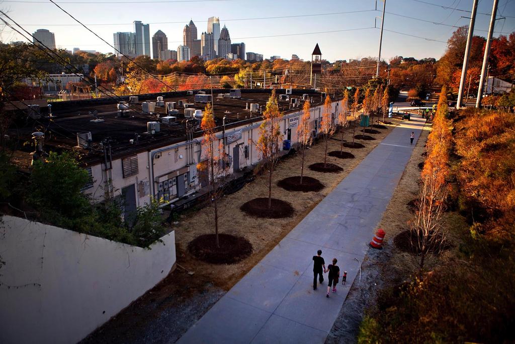
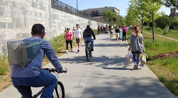
11 Atlanta URBAN Eastside Trail Atlanta, Georgia
12


13 SUBURBAN Leon Creek Greenway San Antonio, Texas

14
15 Methods Direct observation (SOPARC) Intercept surveys May August 2015 Data Analysis Chi square tests ANOVA Descriptives ArcGIS
16 Direct Observation System for Observing Play and Recreation in Communities (SOPARC) Sample size Leon Creek Greenway: 464 Eastside Trail: 2,111* Adequate coverage throughout time of day and day of week 30-minute intervals Construct basic profile of users Observer trained by experienced SOPARC researcher
17 Intercept Surveys Greenway access points Adequate temporal coverage Incentives Cold water in Atlanta and shade in San Antonio Approached as many users as possible Response rate Leon Creek Greenway: 78% Eastside Trail: 65% Sample size Leon Creek Greenway: 429 Eastside Trail: 505
18 Intercept Surveys Items Demographics Use patterns Access Motivations Importance/Performance Perceived Benefits

19
20 Eastside Trail (Urban) Race/Ethnicity Whte Hispanic/Latino Af. American/Black Other Observed Reported

21 Leon Creek Greenway (Suburban) Race/Ethnicity White Hispanic/Latino Af. American/Black Other Observed Reported
 Eastside Trail")
22 Race/Ethnicity (% of Observed Users) Leon Creek (Suburban) Eastside Trail (Urban)
23 Age, Gender & Education Majority adult Eastside Trail (Urban): 96% adult Leon Creek (Suburban): 92% adult Majority male Eastside Trail (Urban): 54% male Leon Creek (Suburban): 62% male Majority college educated Eastside Trail (Urban): 93% college degree Leon Creek (Suburban): 80% college degree


24 Activity Distribution (%) Leon Creek Greenway (Suburban) Skate Eastside Trail (Urban) Skate Bicycle Walk Bicycle Walk Run Run
25 Trip Purpose (%) Leon Creek (Suburban) Eastside Trail (Urban)
26 Density & Distance Density of users (per 30 minutes) Eastside Trail (Urban): 169 users Leon Creek (Suburban): 25 users Distance from home ZIP Code to trail Eastside Trail (Urban): 1.3 miles Leon Creek (Suburban): 3.7 miles


27 Mode of access to trail Leon Creek Greenway (Suburban) Public Transportation Eastside Trail (Urban) Walk/Bicycle Car Car Walk/Bicycle
 Eastside Trail (Urban) 0")
28 Motivations to visit trail Leon Creek (Suburban) Eastside Trail (Urban) 0
29 Perceived Benefits Environmental Protect city s air quality Protection against extreme weather Protect the city s water quality Experiential Provides important habitat for plants and animals Provides a place for outdoor recreation Provides attractive natural scenery Provides a place for people to experience nature Cultural Connects people from different neighborhoods Creates economic benefits Cultural or historical significance in local communities
")
30 Perceived Benefits Environmental Experiential Cultural Leon Creek (Suburban) Eastside Trail (Urban)
31 Urban vs Suburban Greenway Users Urban Greenway Access by walking/bicycling Live less than 3 miles away Connects many destinations Unique motivation to socialize Unique benefits Economic Community connectivity/transportation Suburban Greenway Access by car Live more than 3 miles away Connects few destinations Unique motivation to experience nature Unique benefits Natural aesthetics Plant/animal habitat
32 Discussion Provides user-based support for Greenway Classification Spectrum Insight to greenway planners for identifying goals and locations of greenways White users do not dominate all greenways Leon Creek Greenway: 52% non-white Atlanta Beltline is constructing trail through different types of neighborhoods
33 Future Research Interviews among residents of adjacent neighborhoods Constraints for non-users Design elements to attract non-users Public involvement in planning decisions Further research on other urban, suburban AND RURAL greenways


34 Questions? Samuel J. Keith
Greenways as an alternative to traditional infrastructure. Green Infrastructure
 Greenways as an alternative to traditional infrastructure Green Infrastructure What is a Greenway? Little (1990) - A linear open space along a natural or human made corridor. Fabos - linked corridors nature
BeltLine Corridor Environmental Study
 BeltLine Corridor Environmental Study Citywide Conversation on Transit and Trails April 2, 2009 Agenda & Introductions Introductions Environmental Study Process Overview of the BeltLine Project BeltLine
Florida State University Libraries
 Florida State University Libraries 2011 Greenways as green magnets: The relationship between the race of greenway users and race in proximal neighborhoods Christopher Coutts and Rebecca Miles Follow this
CITY OF SNELLVILLE GREENWAY MASTER PLAN
 CITY OF SNELLVILLE GREENWAY MASTER PLAN NOVEMBER 2017 This page intentionally left blank. INTRODUCTION Greenways are a hot topic in planning and urbanism circles. Many communities across Georgia and the
CAL POLY MASTER PLAN UPDATE, March 2015
 Some Key Themes in the General Guiding Principles Academic Mission The plan must foremost advance the University s academic mission and student success. Foresight and Adaptability The plan should take
METROPOLITAN COUNCIL 390 North Robert Street, St. Paul, MN Phone (651) ; TDD (651)
 ; TDD (651)") DATE: October 24, 2012 METROPOLITAN COUNCIL 390 North Robert Street, St. Paul, MN 55101 Phone (651) 602-1000; TDD (651) 291-0904 TO: Metropolitan Parks and Open Space Commission FROM: Tori Dupre, Senior
DATE: October 24, 2012 METROPOLITAN COUNCIL 390 North Robert Street, St. Paul, MN 55101 Phone (651) 602-1000; TDD (651) 291-0904 TO: Metropolitan Parks and Open Space Commission FROM: Tori Dupre, Senior
BeltLine Corridor Environmental Study
 BeltLine Corridor Environmental Study Joint TAC and SAC Meeting December 8, 2008 What We Will Discuss Today Outreach and Agency Coordination Scoping Results Existing Conditions Historical and Archeological
LEED for Neighborhood Development. A Brief Overview
 LEED for Neighborhood Development A Brief Overview What is LEED ND? LEED for Neighborhood Development First national standard for neighborhood design Developed as a partnership U.S. Green Building Council
Perceptions of the New Urban Greenways in the Pearl River Delta, China
 Proceedings of the Fábos Conference on Landscape and Greenway Planning Volume 6 Adapting to Expanding and Contracting Cities Article 36 2019 Perceptions of the New Urban Greenways in the Pearl River Delta,
Atlanta BeltLine Corridor Environmental Study. Scoping Meeting August 2008
 Atlanta BeltLine Corridor Environmental Study Scoping Meeting August 2008 What Will We Be Discussing Today? Study Overview - How Did We Get Here? - What Is the Study About? - Who Is Involved? - Where Is
FUNDING CORRIDOR REVITALIZATION
 FUNDING CORRIDOR REVITALIZATION Integrated corridor planning for the 21 st Century America Planning Association Annual Conference Atlanta, GA April 27, 2014 Mariia Zimmerman, MZ Strategies, LLC mariia@mzstrategies.com
PARKS AND RECREATION
 PARKS AND RECREATION WHAT YOU WILL FIND IN THIS CHAPTER: Background information on the development of the Park, Recreation, and System Plan (PRSP). General overview of Ellensburg s parks and recreation
But What About the People? The Role of Urban Planning and Green Infrastructure
 But What About the People? The Role of Urban Planning and Green Infrastructure The Southeast Conservation Adaptation Strategy: A Model for Collaborative Conservation David Rouse, FAICP, ASLA Managing Director,
2011 ASLA Design Awards. Westside Creeks Restoration Plan Merit Award AECOM, Fort Collins. Planning & Urban Design
 2011 ASLA Design Awards Westside Creeks Restoration Plan Merit Award AECOM, Fort Collins Planning & Urban Design Project Fact Sheet Category of Entry: Rotating Specialty Award: 2011 2011 ASLA Colorado
Silverdale Regional Center
 Silverdale Regional Center Vision for Silverdale Regional Center The Silverdale Regional Center Plan (Plan) will guide the evolution of the Silverdale Regional Center from a collection of strip malls and
City of Missoula and Missoula County Open Space Planning Open House
 City of Missoula and Missoula County Open Space Planning Open House FEBRUARY 6, 2018 The following slides contain the display board content from the open house. Please use boards to answer questions in
Arlington, Virginia is a worldclass
 EXECUTIVE S U M M A RY Arlington maintains a rich variety of stable neighborhoods, quality schools and enlightened land use policies, and received the Environmental Protection Agency s highest award for
Prepared for the Citizens of Forsyth County by the City-County Planning Board
 Prepared for the Citizens of Forsyth County by the City-County Planning Board Bryce A. Stuart Municipal Building 100 East First Street, Winston-Salem, NC 27101 336.727.8000 www.cityofws.org/planning www.legacy2030.com
Nanaimo OCP Community Consultation
 Nanaimo OCP Community Consultation November 18, 2006 Cheeying Ho, Smart Growth BC Outline Problems with conventional development patterns Smart growth principles Plan Nanaimo 5 goals Progress and areas
Plano Tomorrow Vision and Policies
 Plano Tomorrow Vision and Policies PLANO TOMORROW PILLARS The Built Environment The Social Environment The Natural Environment The Economic Environment Land Use and Urban Design Transportation Housing
Atlanta BeltLine Subarea 3 Master Plan Update
 Atlanta BeltLine Subarea 3 Master Plan Update April 14, 2018 Workshop Meeting 1 22 miles, connecting 45 neighborhoods 22 MILES of transit 46 MILES of streetscapes and complete streets 33 MILES of urban
HE VISION. Building a Better Connected Place
 HE VISION Building a Better Connected Place WALK INTO THE FUTURE. Life in Cranberry, 2030 Here s what our residents told us they wanted to see in their community by 2030: The Cranberry of 2030 is a place
SPRINGFIELD, MA Technical Assistance Panel (TAP)
") SPRINGFIELD, MA Technical Assistance Panel (TAP) ULI the Urban Land Institute Mission To provide leadership in the responsible use of land and in creating and sustaining thriving communities worldwide.
SPRINGFIELD, MA Technical Assistance Panel (TAP) ULI the Urban Land Institute Mission To provide leadership in the responsible use of land and in creating and sustaining thriving communities worldwide.
PROGRAMMING & PUBLIC INVOLVEMENT
 PROGRAMMING & PUBLIC INVOLVEMENT G O A L S & O B J E C T I V E S vision statement Promoting community by establishing an exemplary Greenway along Little Sugar Creek connecting people and neighborhoods
TOD 203 CORRIDOR PLANNING and TOD
 2 CORRIDOR PLANNING and Scales of What You Will Learn The Transit Corridor Types of Corridors Objectives and Strategies for Transit and at the Corridor Level Main Street Corridor Planning and Your Trainers
LAND USE DESIGNATIONS AND ZONING CLASSIFICATIONS
 LAND USE DESIGNATIONS AND ZONING CLASSIFICATIONS One of the most significant issues addressed within the community plan process is land use. How land is utilized within a community directly affects the
M-NCPPC Park System in
 Park Planning & Stewardship Division Park & Trail Planning Section East County Science Center Master Plan Parks, Recreation, Trails, and Open Space- Issues and Opportunities PARK PLANNING & STEWARDSHIP
A Comparative Study on the Utilization Configuration and Characters of Urban Comprehensive Park in China and Korea
 International Conference on Management Science and Innovative Education (MSIE 5) A Comparative Study on the Utilization Configuration and Characters of Urban Comprehensive Park in China and Korea Xiaoyan
Santa Cruz River Master Plan. Presented to the Arizona Floodplain Management Association Spring Conference June 8-10, 2011
 Santa Cruz River Master Plan Presented to the Arizona Floodplain Management Association Spring Conference June 8-10, 2011 Introduction Who is FICO? 2 Project Team Kimley-Horn and Associates, Inc. River
Glenborough at Easton Land Use Master Plan
 Vision Statement Sunrise Blvd. Hazel Ave. Prairie City Rd. Gencorp Property Lincoln Regional Airport 1.0 VISION STATEMENT The identifies City of the principles, goals, policies, and standards Lincoln that
Concord Community Reuse Project Goals and Guiding Principles. Overarching Goals (OG)
") Concord Community Reuse Project Goals and Guiding Principles Overarching Goals (OG) No priority is implied by the order of presentation of the goals and guiding principles. Overarching goals for the Concord
Concord Community Reuse Project Goals and Guiding Principles Overarching Goals (OG) No priority is implied by the order of presentation of the goals and guiding principles. Overarching goals for the Concord
Comprehensive Parks and Recreation Master Plan. Executive Summary. Submitted To: City of Milton, GA October 2012
 Comprehensive Parks and Recreation Master Plan Executive Summary Submitted To: City of Milton, GA October 2012 Executive Summary The City of Milton envisioned the need for an effective Master Planning
CREATING COMMUNITY THROUGH DESIGN
 CREATING COMMUNITY THROUGH DESIGN KENTUCKY LEAGUE OF CITIES OCTOBER 10, 2012 J ayo u n g Ko o, P h. D. A ssistant E x tension P ro fessor Depar t m ent o f L a n d scape A r c h itectu r e & CEDIK University
Secrest Short Cut and Monroe Expressway Small Area Plan AUGUST 29, 2018
 Secrest Short Cut and Monroe Expressway Small Area Plan AUGUST 29, 2018 Background and Process Monroe Expressway will be open by the end of 2018 Union County and Indian Trail identified a need to revisit
East Bench Master Plan Update
 Community & Economic Development Office of the Director East Bench Master Plan Update To: From: Planning Commission Wayne Mills, Senior Planner Date: November 18, 2015 CC: Re: Nora Shepard, City Planning
This page intentionally blank.
 This page intentionally blank. Parks, Recreation, and Open Space Chapter Relationship to Vision Vision Parks, Recreation and Open Space Chapter Concepts County Government. County government that is accountable
UPPER BRODHEAD CREEK PARADISE CREEK GREENWAY PLAN
 UPPER BRODHEAD CREEK PARADISE CREEK GREENWAY PLAN The Upper Brodhead & Paradise Creeks Greenway Cooperating Municipalities Mount Pocono Borough Paradise Township Barrett Township Price Township Funding
Gather information from online resources covering the following topics:
 Assignment #1: Regional Analysis Project Site Location: Greater Boston Area What comprises a region? The many elements within a region comprise the region as a whole. Natural as well as manmade environmental
The Value Proposition of New Urban Parks in Small Cities: Exploring Newburgh, New York as a Prototypical Case Study
 The Value Proposition of New Urban Parks in Small Cities: Exploring Newburgh, New York as a Prototypical Case Study By Arianna Koudounas Georgetown MURP December 2015 SAFE HARBORS GREEN Newburgh, NY NOW
KEY FINDINGS. Community Engagement + Research
 PROJECT OVERVIEW PROJECT OVERVIEW PROJECT OVERVIEW KEY FINDINGS Community Engagement + Research Community Engagement Community Issues Workshop Steering Committee Workshop City Council/Planning Workshop
University City Area Plan
 University City Area Plan Economic Development & Planning Committee June 6, 2007 Purpose of the Meeting Provide an overview of the plan Set a date for public comment with City Council Mallard Creek Church
1 ESRI User Conference Eastside Greenway
 1 ESRI User Conference Eastside Greenway Grand Rapids, Michigan ~200,000 residents 45 sq. miles Leader in smart public investment Green infrastructure program ArtPrize BeerCity USA 2 ESRI User Conference
City of Surrey Ecosystem Management Study. Integration of ecological processes with land use
 City of Surrey Ecosystem Management Study Integration of ecological processes with land use Natural areas in Surrey are changing as the City grows and evolves. Many important natural areas remain or may
Guiding Principles, Objectives, Strategies and Policies
 Guiding Principles, Objectives, Strategies and Policies Section 1 Introduction These Guiding Principles were adopted as part of the 1999 Athens-Clarke County Comprehensive Plan and are carried over, in
NACCED/NACo CONFERENCE JULY 10, 2015
 NACCED/NACo CONFERENCE JULY 10, 2015 Regional Growth Framework 2 Regional Growth Framework Regional Priorities Preferred Growth Concept Tools to Support Local Governments 3 Top Priorities for the CONNECT
Shifting Paradigms Urban Planning and Town Center Development in the United States
 Timothy H. Haahs PE, AIA April 20, 2010 Shifting Paradigms Urban Planning and Town Center Development in the United States Urban Life "The street is the river of life." Trends / 국민일보 2010 년 3 월 1 일자발췌
SPRINGHILL LAKE TRANSIT VILLAGE
 Greenbelt Metro Area Sector Plan - Subarea Design Policies and Guidelines - Springhill Lake Transit Village 113 SPRINGHILL LAKE TRANSIT VILLAGE Residential Neighborhood and Village Center CONCEPT Springhill
Webinar: Economic Impacts from Bicycle and Pedestrian Street Improvements
 Portland State University PDXScholar TREC Webinar Series Transportation Research and Education Center (TREC) 4-25-2017 Webinar: Economic Impacts from Bicycle and Pedestrian Street Improvements Jenny H.
Horizon 2035 Land Use and Transportation Element
 CITY OF SUNNYVALE Horizon 2035 Land Use and Transportation Element City Council Study Session March 7, 2017 Overview General Plan Context Mixed Use Villages Transportation Mode & Parking General Plan Policy
Northern Territory Compact Urban Growth Policy
 Northern Territory Compact Urban Growth Policy A Reference Policy Document to clause 2.7 (Reference to Policy) of the NT Planning Scheme May 2015 Table of Contents 1 Policy Setting... 3 1.1 Context for
Clovis Urban Greening Plan. Community Workshop #2 Northwest
 Clovis Urban Greening Plan Community Workshop #2 Northwest Thursday, October 9, 2014 WHAT IS AN URBAN GREENING PLAN? A guide to help the City to improve quality of life for residents Identification of
Creating Complete Roadway Corridors:
 Creating Complete Roadway Corridors: The AASHTO Guide to Transportation Landscape Architecture and Environmental Design NCHRP Project 15-33 Status Report AASHTO Standing Committee on Design Technical Committee
Create a connected ecological network. Connect districts with transit. Let the centre define the community
 District A - D Southeast False Creek A 1 A 2 A 3 A 4 Create a connected ecological network Connect districts with transit Let the centre define the community Provide a variety of affordable housing types
A Vision for Walnut Creek
 A Vision for Walnut Creek Photo: City of Clive Walnut Creek Booklet 8 of 8 Greater Des Moines Water Trails and Greenways 1 Table of Contents Booklet 1: Water Trails Strategies and Policies Booklet 2: Beaver
A Practicum for NRLI Class X April 14, Tom Abbott USDA-ARS
 A Practicum for NRLI Class X April 14, 2011 Tom Abbott USDA-ARS Problem Childhood obesity Poverty Poor diets Food insecurity Decaying urban neighborhoods Environmental degradation Lack of Ecological Understanding
The Need to Develop a Transit Ready Community
 Evaluation & Appraisal Report (EAR) Major Issue # 6 The Need to Develop a Transit Ready Community July 3, 2007 EAR Major Issue # 6 Transit Ready Existing Comp Plan policies apply only to Indiantown Road:
Midtown Greenway PROJECT REPORT CARD
 Midtown Greenway PROJECT REPORT CARD Project Overview and History The Midtown Greenway is a 5.5-mile multi-use trail that connects the Mississippi River to the Minneapolis Chain of Lakes. The corridor,
Northeast Everglades Natural Area
 Northern Palm Beach County Natural Areas Master Plan Northeast Everglades Natural Area August 3, 2006 GLATTING JACKSON KERCHER ANGLIN LOPEZ RINEHART, INC. Community Planning 1 Public Land Partners Agenda
The City shall enhance and improve the accessibility of parks and recreational facilities while protecting their quality. by:
 GOALS, OBJECTIVES AND POLICIES GOAL 1: To provide open space and recreation as an essential element needed for the betterment of the City s character and quality of urban life. The City shall plan for
Creating Quality Places: Successful Communities by Design
 Creating Quality Places: Successful Communities by Design Communities across the metropolitan Kansas City area are growing. Our challenge is to shape future development in ways that will maintain and enhance
CHAPTER 8 ISSUES, CONCERNS, CONSTRAINTS AND OPPORTUNITIES
 CHAPTER 8 ISSUES, CONCERNS, CONSTRAINTS AND OPPORTUNITIES Introduction This River Conservation Plan was developed during a time of tremendous activity and effort in planning the transformation of the Delaware
Diridon Station Area: Framework for Implementation
 Diridon Station Area: Framework for Implementation LAND USE MISSION: The Diridon Station Area is the most significant opportunity for placemaking in San Jose. Development should integrate and expand into
RECREATION AND OPEN SPACE ELEMENT GOALS, OBJECTIVES, AND POLICIES
 RECREATION AND OPEN SPACE ELEMENT GOALS, OBJECTIVES, AND POLICIES Goal 7 To provide park facilities, recreation programs, and open space resources that are safe, adequate, and accessible to all City residents,
GREATER DES MOINES WATER TRAILS AND GREENWAYS PLAN
 GREATER DES MOINES WATER TRAILS AND GREENWAYS PLAN A shared vision for our rivers, creeks and greenways. www. Des Moines Area MPO Iowa Department of Natural Resources Iowa s First Regional Water Trails
Sustainably Repositioning Greyfield Sites. Greyfield Sites Anywhere
 Sustainably Repositioning Greyfield Sites Jim Constantine Looney Ricks Kiss Architects Todd Poole 4ward Planning Greyfield Sites Anywhere Pennsylvania Chapter American Planning Association Conference 2009
GREATER DES MOINES WATER TRAILS AND GREENWAYS PLAN
 GREATER DES MOINES WATER TRAILS AND GREENWAYS PLAN A shared vision for our rivers, creeks and greenways. www. Des Moines Area MPO Iowa Department of Natural Resources Iowa s First Regional Water Trails
Communities Plan. Parkland-Spanaway-Midland. LUAC Review of Draft Policies
 Parkland-Spanaway-Midland Communities Plan LUAC Review of Draft Policies Presented by: Tiffany O Dell, Senior Planner Planning & Public Works Tiffany.Odell@co.pierce.wa.us 253-798-6859 November 1, 2017
PLACE ATTACHMENT OF RESIDENTS TO GREEN INFRASTRUCTURE NETWORK IN SMALL TOWN
 1 PLACE ATTACHMENT OF RESIDENTS TO GREEN INFRASTRUCTURE NETWORK IN SMALL TOWN Ismail Said(PhD) Faculty of Built Environment, Universiti Teknologi Malaysia Associate Professor, Department of Landscape Architecture,
Parks, and Recreation & Cultural Arts Master Plan Update
 Parks, and Recreation & Cultural Arts Master Plan Update Community Profile Public Input Summary: Staff Interviews conducted April 14 and 15, 2014 Citizens Workshop - conducted April 15 th and 24 th, May
Campus planning: Physical roadmap for the future. Long term: years. As for the future, your task is not to foresee it, but to enable it.
 Campus planning: Physical roadmap for the future Long term: 20-50 years As for the future, your task is not to foresee it, but to enable it. --Antoine de Saint Exupery Middlebury College master plan Andropogon
Making Transit Oriented Development Work For Boonton, NJ
 Making Transit Oriented Development Work For Boonton, NJ Bloustein School of Planning and Public Policy Studio Dan Burton Loannie Dao Webster Slater Brandon Williams Ian Watson Maria Laham Nicola Mammes
City of Charlottesville
 City of Charlottesville MEMORANDUM To: Charlottesville Planning Commission From: Ebony Walden, Neighborhood Planner and Missy Creasy, Planning Manager Date: November 15, 2012 Re: Comprehensive Plan Fall
Fort Ord Regional Trails Planning
 Fort Ord Regional Trails Planning FORA Board July 11, 2014 Josh Metz, Associate Planner Overview Base Reuse Plan (BRP) trails planning context Trails planning in FORA jurisdictions and related entities
TABLE OF CONTENTS. Transportation Chapter 1 - Introduction and Purpose of Planning to 1-3. Utilities
 Chapter 1 - Introduction and Purpose of Planning... 1-1 to 1-3 Pennsylvania Municipalities Planning Code (Act 247)...1-1 Previous County Planning Activities...1-1 Objectives of the Plan...1-2 Elements
LAND USE MODEL UPDATE. Planning and Land Use Advisory Committee Meeting #2 September 4, 2014
 1 LAND USE MODEL UPDATE Planning and Land Use Advisory Committee Meeting #2 September 4, 2014 2 Presentation Outline Introduction and Recap Model Process Study Design Place Types Suitability Factors 3
Community Open House March 26 th, 2018
 Community Open House March 26 th, 2018 Open House Agenda 1. Overview of Planning Process What we heard 2. Future Land Use Policy 3. Priority Growth Areas 4. Plan Elements Making it happen What is a Comprehensive
COMPREHENSIVE PLAN & UNIFIED DEVELOPMENT ORDINANCE
 Village of Forsyth COMPREHENSIVE PLAN & UNIFIED DEVELOPMENT ORDINANCE Community Planning #6 Prepared by: Vision Statement We envision the Forsyth Community as one which will continue to maintain a small
Fun Facts 2030 Population Projection 2,694,800 Or 994,800 New Residents By 2030 (PBC) Urban Redevelopment Area (URA)
 Urban Redevelopment Area (URA)") Palm Beach County Urban Redevelopment Area (URA) Addressing Redevelopment in Central Palm Beach County Friday September 15, 2006 Fun Facts 2030 Population Projection 2,694,800 Or 994,800 New Residents
Palm Beach County Urban Redevelopment Area (URA) Addressing Redevelopment in Central Palm Beach County Friday September 15, 2006 Fun Facts 2030 Population Projection 2,694,800 Or 994,800 New Residents
McDaniel Creek Master Plan
 McDaniel Creek Master Plan UNIVERSITY AVE., PITTSBURGH NEIGHBORHOOD AND THE MCDANIEL CREEK WATERSHED 60 ANSLEY MALL AND THE CLEAR CREEK GREENWAY 61 INTRODUCTION The BeltLine Subarea 6 site lies within
Washington Park Diagonal
 Public Input Meeting August 3, 2011 Nicole Stahly RLA DPR Project Manager Jesse Clark RLA, LEED Stream Design Paul Thomas RLA Stream Design Kerry White RLA Urban Play Studio Tonight s Agenda 1st Meeting:
Welcome to the first Community Workshop for Wesley Heights Greenway Cedar Street to Bruns Avenue
 Welcome to the first Community Workshop for Wesley Heights Greenway Cedar Street to Bruns Avenue What is a Greenway? Active Transportation Linear Public Park Recreation Health and Fitness Desirable Amenity
12/9/2013. HOLLYWOOD/PINES CORRIDOR PROJECT AMPO 2013 Annual Conference October 24, Our Perspective. Broward.
 HOLLYWOOD/PINES CORRIDOR PROJECT AMPO 2013 Annual Conference October 24, 2013 Our Perspective Broward Fort Lauderdale 1 Broward Metropolitan Planning Organization Fort Lauderdale Fort Lauderdale Skyline
Chapter 7. Green Infrastructure
 Chapter 7. Green Infrastructure 45 7.1 What is Green Infrastructure? The Environmental Protection Agency classifies green infrastructure as an approach to wet weather management that is cost-effective,
20 International Conference of The Coastal Society THE ROLE OF PLANNED UNIT DEVELOPMENTS IN ENVIRONMENTAL MANAGEMENT IN THE COASTAL ZONE
 th 20 International Conference of The Coastal Society THE ROLE OF PLANNED UNIT DEVELOPMENTS IN ENVIRONMENTAL MANAGEMENT IN THE COASTAL ZONE Kathleen E. Semon, University of South Carolina Braxton C. Davis,
Warren County/Bowling Green Focus 2030 Comprehensive Plan VOLUME 1 INDEX
 Appendix 5: Index VOLUME 1 INDEX A Aesthetics ES-6, FLU-15, FLU-17, FLU-24, NCR-7 Agricultural Base FLU-18, FLU-20 Agricultural Centers, Rural FLU-11 Agricultural District NCR-17-NCR-18 Agricultural Economy
Chapter 1: Introduction
 Chapter 1: Introduction The Penn Avenue Community Works Corridor Vision and Implementation Framework presents an integrated communitybased vision and a coordinated, long-term implementation framework for
3. VISION AND GOALS. Vision Statement. Goals, Objectives and Policies
 Vision Statement Queen Creek s interconnected network of parks, trails, open spaces and recreation opportunities provide safe and diverse activities and programs that sustain its unique, small town, equestrian
Date: April 10, 2017 City Council Work Session April 24, 2017: Status Report on the Comprehensive Plan Update and Transportation Master Plan
 AGENDA REPORT To: From: By: Honorable Mayor and City Council Members Warren Hutmacher, City Manager Sharon Ebert, Director Community Development Date: April 10, 2017 Agenda: City Council Work Session April
What. - Civic anchors including a park and an updated library branch
 SUMMARY What Master Plan aimed at delivering - A walkable, mixed-use downtown in the heart of University City anchored by UNC Charlotte and University Research Park - Civic anchors including a park and
Southwest Fleetwood Enclave
 Southwest Fleetwood Enclave Development Concept Plan Southwest Fleetwood Enclave 1 st Land Owners Meeting April 30 th, 2012 Presentation Overview Why the Plan? ; Overview & Purpose of Study; Constraints
Parks, Open Space and Trails
 Introduction Parks have often been referred as the lungs of our cities, cleansing the air of pollutants and particulate matter. Parks are also gathering places for families and community. They offer spaces
COMMISSION ACTION FORM
 ITEM #: 6 DATE: 10-18-17 COMMISSION ACTION FORM REQUEST: Public Hearing on Proposed Amendments to the Ames Urban Fringe Future Land Map and Land Use Policy Plan for the North Growth Gap Area BACKGROUND
CHAPTER 8. Mrs. Zimman s Class - Central Elementary
 SUSTAINABILITY CHAPTER 8 Mrs. Zimman s Class - Central Elementary 8.1 OVERVIEW Green infrastructure also known as low impact development (LID) and environmental or sustainable site design is an environmentally
Pungo/Blackwater Planning Area
 Pungo/Blackwater Planning Area Current Reality The Pungo/Blackwater Planning Area represents the rural landscape and lifestyle that encompasses nearly 40% of Virginia Beach. The Agricultural Reserve Program
Comprehensive Park System Master Plan
 PARKS AND RECREATION Comprehensive Park System Master Plan Citizen Advisory Committee, June 5, 2012 - Meeting Notes Transcription MIG met with the Parks Citizen Advisory Committee on Tuesday, June 5th,
M E T R O P O L I T A N
 METROPOLITAN PROJECT Located in the heart of Midtown Charlotte, N.C., Metropolitan is the first urban mixed-use destination in the Queen City. With nearly 172,000 square feet of high-quality dining and
Shared History, Shared Future
 Open Space is Shared History, Shared Future Builds upon past and current regional planning: PSP Action Agenda, Vision 2040, the Cascade Agenda, and Mountains to Sound Greenway The ROSS Approach Building
Isabel Neighborhood Plan: Alternatives
 Isabel Neighborhood Plan: Alternatives Presented by: Lori Parks, Associate Planner February 2, 2015 Agenda 1. Background on BART to Livermore 2. Isabel Neighborhood Plan 3. Alternative Scenarios 4. General
Howard W. Peak Greenway Trails
 Howard W. Peak Greenway Trails Program Beginnings 1998 - Mayor Howard Peak and other Council members initiated and supported idea of creating linear parks along San Antonio creekways. 1999 - Program plan
DEVELOPMENT FRAMEWORK POST 2030 LAND USE PLAN INTRODUCTION
 INTRODUCTION Oak Grove s Comprehensive Plan identifies a future Metropolitan Urban Service Area (MUSA). The Metropolitan Council does not anticipate extending utilities to this area prior to 2030. The