ALLEN CREEK GREENWAY. Citizens Advisory Committee Meeting #5 July 19, Allen Creek Greenway Master Plan. July 2017
|
|
|
- Sandra Martin
- 5 years ago
- Views:
Transcription

1 1 ALLEN CREEK GREENWAY MASTER PLAN Citizens Advisory Committee Meeting #5 July 19, 2017
2 Agenda 2 Final DRAFT Preferred Plan (30 min) Master Plan Document Outline (5 min) Potential Implementation Strategy & Branding Roll-out (25 min) Small Group Discussion & Report Out (50 minutes) Next Steps (5 min) Public Commentary (3 min/ person)
3 Project Schedule 3 Technical Advisory Committee Meeting Citizens Advisory Committee Meeting Community-Wide Meeting Stakeholder Focus Group Meeting(s) September October November December January February March April May June July August September October November December January February March April May June July August September October November December Janurary Task 1: PROJECT INITIATION Step 1. Project Kick-off & Consultant Selection Step 2. Existing Conditions Analysis Step 3. Issues & Opportunities Analysis Intro Meeting (11/19) Task 2: PLANNING OBJECTIVES & OPTIONS, IMPACT ANALYSIS & COST SCENARIOS 1 TAC#1 2 TAC#2 1 CAC#1 (5/4) CM#1 (6/16) 1 Step 1. Planning Objectives & Option Scenarios 3 2 Step 2. Impact Analysis and Cost Scenarios TAC#3 CAC#2 (9/14) 4 TAC#4 Task 3: MASTER PLAN RECOMMENDATIONS & STRATEGIES TAC#5 CM#2 (2/16) Step 1. Prioritize Conceptual Level Planning Options Step 2. Develop Draft Recommendations & Strategies Task 4: MASTER PLAN DOCUMENTATION & ACTIONS CAC#3 (1/11) SH Open House (2/1) 6 4 TAC#6 CAC#4 (4/19) Step 1. Develop Draft Plan Documents Step 2. Develop Draft Implementation & Management Plan Step 3. Prepare Final Draft Documentation Step 4. Master Plan Review & Adoption 7 TAC#7 CAC#5 (7/19) 5 8 TAC#8 CAC#6 (9/13) 6 3 CM#3 (10/4)

4 4 FINAL DRAFT PREFERRED PLAN

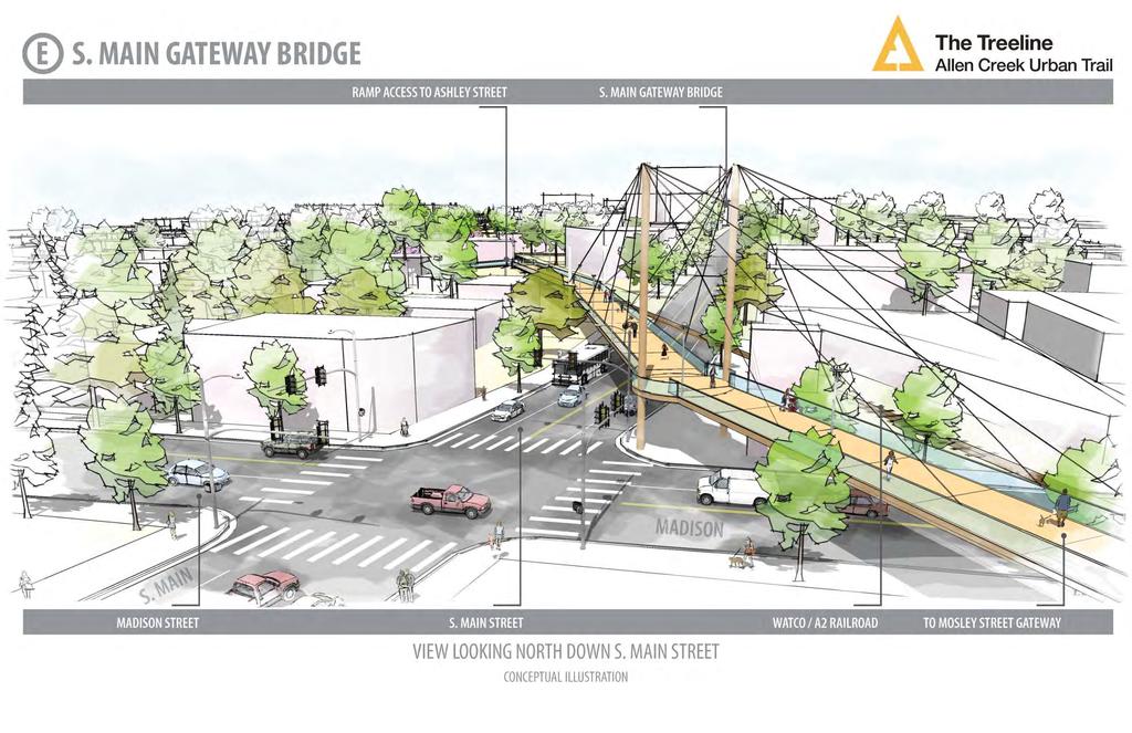
5 DRAFT Preferred Plan FRAMEWORK TERMINOLOGY 5 Gateways (Major & Minor) Part of the primary framework Near-Term Opportunities To advance complete connection (shown with thinner lines) Future Public Site Improvements Potential opportunity sites on public lands Connector Paths Part of primary framework or future phase N O R T H Primary Trail Implementation strategy and phasing approach (shown with thicker lines) Private Properties Properties where access easements or other agreements are needed. Coordinating Projects Adjacent and related projects requiring coordination efforts. (e.g. Berm Opening, Huron Street Design, etc.)

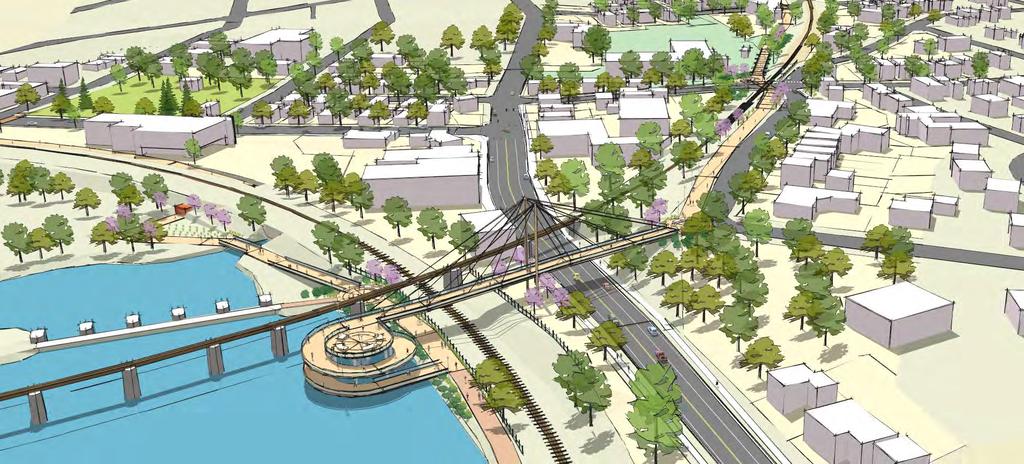
6 DRAFT Preferred Plan 6 Viability of options within the rail corridor is dependent on further discussion and review with Watco Companies. N O R T H The Framework Plan will function as a strategy or roadmap for pursuing implementation. Aggregated the four prior options into a hybrid plan that considers: 1. Feasibility (property access, engineering) 2. Continuity (e.g. bridging over challenging intersections) 3. User experience & safety 4. Connectivity to assets & destinations (public parcels, parks, future improvement sites, commercial destinations, etc.) 5. Unique experiences & landmark opportunities

7 DRAFT Framework Plan Zone 1 Viability of options within the rail corridor is dependent on further discussion and review with Watco Companies. 7? N O R T H


8 DRAFT Framework Plan Zone 2 A Viability of options within the rail corridor is dependent on further discussion and review with Watco Companies. 8? N O R T H


9 DRAFT Framework Plan Zone 3 Viability of options within the rail corridor is dependent on further discussion and review with Watco Companies. 9 B N O R T H? A

10 DRAFT Framework Plan Zone 4 Viability of options within the rail corridor is dependent on further discussion and review with Watco Companies. 10 B C? N O R T H


11 DRAFT Framework Plan Zone 5 Viability of options within the rail corridor is dependent on further discussion and review with Watco Companies. 11 C? D N O R T H

12 DRAFT Framework Plan Zone 6 Viability of options within the rail corridor is dependent on further discussion and review with Watco Companies. 12 D E? N O R T H

13 DRAFT Framework Plan Zone 7 Viability of options within the rail corridor is dependent on further discussion and review with Watco Companies. 13 E N O R T H?


14 Preferred Cross-Sections: Trail on Public/Private Parcels Preferred dimensions: 30 in width preferred for the trail corridor and amenities Paved trail width will vary 20 preferred width Separated pedestrian and bicycle flow where space allows Expanded areas, where possible, for additional landscape, habitat, or other open space features Stormwater managed through combination of surface and underground treatments. 14 Trail cross-sections reflect preferred design. Actual dimensions and details will vary on a site-by-site basis.

15 Preferred Cross-Sections: Trail adjacent to Railroad Railroad "envelope" is 9' from center of tracks that must be clear. Other rail with trail projects typically 25 from center of tracks, and down to Will require secure fencing to separate trail from active rail line. Railroad corridor is typically 50 in width, limiting ability to accommodate trail fully within the corridor. Trail cross-sections reflect preferred design. Actual dimensions and details will vary on a site-by-site basis. Viability of options within the rail corridor is dependent on further discussion and review with Watco Companies.


16 Preferred Cross-Sections: Trail within Street Right-of-Way 16 Street right-of-way is typically 66 wide Expand sidewalk and construct a cycle track on one side of the street with removal of parking lane. Landscaping enhancement on both sides of the street Enhancements to all ongrade street crossings and intersections planned. Trail cross-sections reflect preferred design. Actual dimensions and details will vary on a site-by-site basis.
 and Universal Access guidelines Connector walks provide access points from adjacent sidewalks to the primary trail section.")
17 Preferred Cross-Sections: Elevated Trail 17 Elevated ramps provide access to bridges for crossing major roads and rail corridors. All ramp sections to meet Americans with Disability Act (ADA) and Universal Access guidelines Connector walks provide access points from adjacent sidewalks to the primary trail section. Trail cross-sections reflect preferred design. Actual dimensions and details will vary on a site-by-site basis.

18 Conceptual Sketches: Overall 18
19 19
20 20
21 21
22 22
23 23
24 24 MASTER PLAN DOCUMENT OUTLINE
25 MASTER PLAN STRUCTURE CHAPTER 1: Introduction Project Overview & Background (scope, impetus, etc.) Project Process & Engagement (working groups, outreach efforts, etc.) Key concepts and assumptions z CHAPTER 2: Corridor Analysis Demographic & community context Transportation analysis (roads, non-motorized, railroad corridor, etc.) Land use & land use change analysis (including open space) Environmental, floodplain analysis Frame each analysis component as issues & opportunities. CHAPTER 3: Urban Trail Vision Overall goals & objectives Preferred cross-sections Route amenities & design assumptions/practices 25 CHAPTER 4: Route Framework Plan Key terminology Primary + near-term routes Key nodes/location graphics Site-level issues and design considerations Back-pocket options (narrative form) CHAPTER 5: Implementation Plan Project zones & cost analysis Phasing strategies / prioritization Maintenance and management needs Governance structure (e.g. partnering arrangement) Funding mechanisms Action Items & Roles/Responsibilities Appendix Items Alternatives analysis evaluation Meeting summaries / other attachments

26 26 POTENTIAL IMPLEMENTATION STRATEGY
 Governed by Board with members from ACGC and the City")
27 Implementation Structure 27 BUSINESS PLAN Goal is to develop a Business Plan concurrently with the completion of the Master Plan. Documents are interrelated. Business Plan addresses Governance, Finances, and Implementation PART 1: Governance Partnership with the Allen Creek Greenway Conservancy (ACGC) Governed by Board with members from ACGC and the City Develop an operating agreement with ACGC as the Managing Partner Managing Partner is responsible for day-to-day operations City approval required for annual budget and major actions Example: Detroit Riverfront Conservancy
 City resources (funds and properties) Grants Donations")
 Funding from operations of facilities Programming of spaces Sponsorships")
28 Implementation Structure 28 PART 2: Financial Objective is to establish dedicated and reliable sources of funds for design/construction AND operation/maintenance Capital (design/construction) City resources (funds and properties) Grants Donations and Sponsorships Debt financing Photo credit: Operating (maintenance/capital repair & replacement) Funding from operations of facilities Programming of spaces Sponsorships Limited City funding envisioned Photo credit:
29 Implementation Structure: Maintenance Activities & Needs 29 Trail surface maintenance Snow clearing (length + width of trail types) Sweeping / Washing Pavement marking maintenance Pavement repair Furnishing Maintenance Cleaning & repair of seating (# of benches) Waste collection (trash + recycling) (# of receptacles) Signage repair / maintenance Light pole repair / maintenance Landscape Maintenance Stormwater (inlet & trap cleaning) Perennial beds (area SF) Tree and shrub trimming / pruning Lawn mowing Fence repair Security Call box maintenance & 911 fees Other Maintenance Signals (RRFB, etc.) Railroad crossing materials/surface maintenance Elevated/bridge inspections Utility inspections / maintenance Programming & Operations Interpretive signage Art installations and selection Trail ambassadors (trail rangers ) Event coordination Coordinating project oversight/coordination

30 Potential Implementation Strategy 30 PART 3: Implementation Strategy Project phasing (including future Phase 2) Detailed planning Acquisition of easements/rights of way Off-street and on-street improvements Project Design Survey, Geotechnical Engineering Permitting & Approvals

31 Potential Implementation Strategy 31 PHASING APPROACH Anticipated to proceed generally from the northern connection to the Border-to-Border trail south. Different trail sections may be developed simultaneously, with near-term linkages providing continuity. (3) South Zone Hill Street to State & Stimson UM + Railroad Property (2) Central Zone William Street to Hill Street Mostly private property (1) North Zone Argo / Border-to-Border Trail to William Street Mostly public and rail property. Some private.

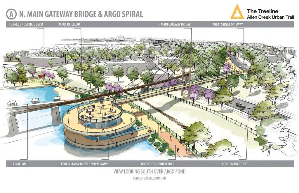
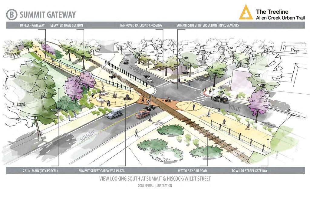
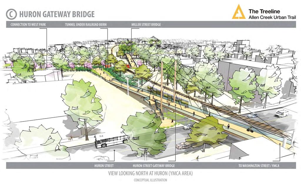
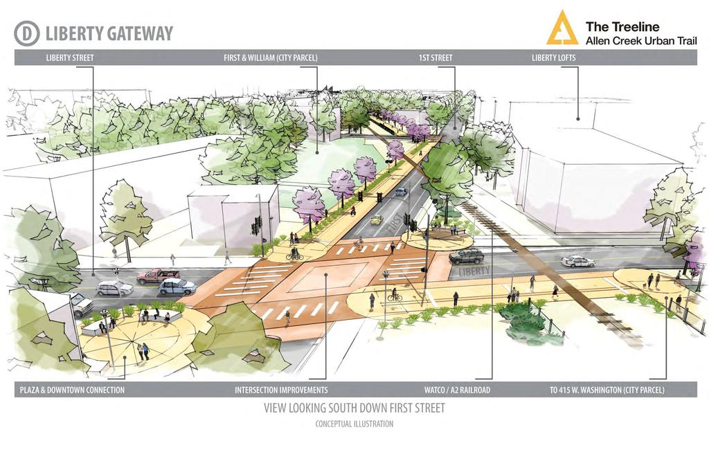
32 Potential Implementation Strategy 32 E D NORTH ZONE CONSIDERATIONS Each zone can be organized into a number of phased Project Areas F C A. North Main Gateway Bridge: Public + rail property. B. MDOT Berm Project: Already in design/engineering with a large portion of funding in place C. Summit to Kingsley: Public property (721 N. Main, street ROWs, and acquired easements) + rail property. D. Miller Bridge: Mostly private property E. Huron Gateway Bridge: 415 W. Washington, YMCA, private property F. Liberty & First Gateways: Public property (1 st & William, Street ROWs) and minor railroad easement. B A
 for the project.")
33 Branding & Marketing Strategy 33 ACGC conducted a branding and marketing effort with Phire Group (Ann Arbor based branding agency) to accomplish the following objectives: Develop a brand identity (name, logo, etc.) for the project. Reduce confusion between greenway and greenbelt Implement a PR and outreach effort to raise the awareness of the project and its goals: Regionally / nationally through media outlets Within funding networks (private donors, granting entities, public) Among potential project partners / sponsors Provide a website for up-to-date information on the project and implementation progress
34 34

35 35 VISION STATEMENT It is The Treeline is an amenity that Ann Arbor residents are proud to have created. The Trail and neighboring parks buzz with activity most hours of the day. Bicyclists and pedestrians on the Border-to-Border Trail use the Trail to reach destinations in downtown Ann Arbor. It provides a comfortable and safe place for neighbors of all ages to connect with each other and to their surroundings. On football Saturdays, thousands of fans use the Trail to walk safely between the Stadium and downtown. Natural and community created amenities along the Trail provide different ways to experience and learn about the community s history, arts scene and environmental ecosystem. The Trail has positively impacted storm water quality in the Allen Creek valley. Rain gardens and storm water rehabilitation have improved water flow during flooding events. The Urban Trail has become an important part of Ann Arbor s identity, enjoyed by residents and visitors alike. It is impossible to imagine Ann Arbor without the Trail.


36 36 CONSERVANCY MISSION STATEMENT The Allen Creek Greenway Conservancy exists to foster the creation of an urban trail that becomes an integral connector of people and places in Ann Arbor. This walking and biking trail will: Bring access to Ann Arbor s river and park system through the heart of downtown along the railroad corridor and Allen Creek floodway. Provide safe passage and recreation from Stadium Boulevard to the Border-to-Border Trail. Invite community gathering and engagement with natural and cultural features. Benefit the community by providing positive economic impact, improved aesthetics, enriched community engagement, rehabilitated storm water management, and enhanced quality of life for present and future generations.
37 DRAFT Framework Plan Cost Analysis 37 Preliminary estimate of potential construction costs: $53-57 million Approx miles in length Approx. $3,800 per linear foot Cost Analysis Includes: Design & Engineering Permitting, Survey, Geotechnical Design, Estimate, and Construction Contingencies Project Management & Construction Administration Trail Amenities & Features Included: All primary trail alignment features and connector paths, including bridges and elevated ramp sections. Trees and landscaping along the trail Benches and other site furnishings Stormwater management for trail area + runoff Pedestrian-scale lighting and security (call boxes) Ornamental security fencing (where needed) Grading, retaining walls, and utility modification (as needed) Cost Analysis Does NOT Include: Any property acquisition/easement costs Major utility modifications or enhancement Environmental remediation Flood mitigation / floodplain enhancement Projection of on-going maintenance costs Other Trail Opportunities shown on the framework plan

38 38 SMALL GROUP DISCUSION
39 Small Group Discussion Expanding the Vision + Implementation 39 After the is adopted and the CAC s work is complete, there will be a need for ongoing Community Champions that are active and dedicated to the implementation of the urban trail. Question #1: What community partners do you feel could be engaged directly in the implementation? What roles or responsibilities could they have? Nature groups / organizations? Recreational interest groups? Institutions? Question #2: Do you have specific ideas for building financial support for implementation and/or on-going operations? Grant sources? Partners? Crowdfunding? Question #3: In what ways would YOU be interested and willing to continue to be involved in the project and advancing implementation? As a trail ambassador Grant writing Funding support / organization Cultural / historic interpretation Conservancy Advisory Council? Record comments and ideas on the provided flip charts.

40 40 NEXT STEPS
41 Next Steps 41 Package for Watco Co./Ann Arbor Railroad CAC Meeting #6 September 13 from 8:30-10:30 a.m. City Hall Council Chambers Community-Wide Meeting #3 October 4, City Hall Council Chambers Approval Process Timeline November 8: Planning Commission Public Hearing (to be confirmed) December 18: City Council Action (to be confirmed)

42 42 REFERENCE
3. VISION AND GOALS. Vision Statement. Goals, Objectives and Policies
 Vision Statement Queen Creek s interconnected network of parks, trails, open spaces and recreation opportunities provide safe and diverse activities and programs that sustain its unique, small town, equestrian
Potential Green Infrastructure Strategies May 6, 2015 Workshop
 Potential Green Infrastructure Strategies May 6, 2015 Workshop Background The City of Cortland is developing the Tioughnioga Urban Headwaters Green Infrastructure Action Plan with funding from the National
Ann Arbor Intermodal Station Environmental Review
 Ann Arbor Intermodal Station Environmental Review Park Advisory Commission September 19, 2017 AGENDA 1. Project Update 2. Draft Environmental Assessment 3. Draft Preferred Alternative 4. Next Steps 5.
Johnson Street Bridge Public Realm Update
 Johnson Street Bridge Public Realm Update August 20, 2015 Background Johnson Street Bridge Replacement Project impacts a diverse range of stakeholders In addition to a new bridge, the project also includes
Scope of Services. River Oaks Boulevard (SH 183) Corridor Master Plan
 Corridor Master Plan") Scope of Services River Oaks Boulevard (SH 183) Corridor Master Plan PROJECT AREA The project area consists of the River Oaks Boulevard (SH 183) corridor bounded by SH 199 at the northern end and the Trinity
Scope of Services River Oaks Boulevard (SH 183) Corridor Master Plan PROJECT AREA The project area consists of the River Oaks Boulevard (SH 183) corridor bounded by SH 199 at the northern end and the Trinity
The transportation system in a community is an
 7 TRANSPORTATION The transportation system in a community is an important factor contributing to the quality of life of the residents. Without a sound transportation system to bring both goods and patrons
City of Plattsburgh DRI: Downtown Streetscapes & Riverfront Access. Downtown Streetscape and Riverfront Access Design
 City of Plattsburgh DRI: Downtown Streetscapes & Riverfront Access Welcome Thank you for coming this evening. Agenda PART I - Project Context The Downtown Revitalization Program Our DRI Projects Other
CITY OF CHARLOTTESVILLE, VIRGINIA CITY COUNCIL AGENDA
 CITY OF CHARLOTTESVILLE, VIRGINIA CITY COUNCIL AGENDA Agenda Date: December 16, 2013 Action Required: Adoption of Resolution Presenter: Staff Contacts: Title: James E. Tolbert, AICP, Director of NDS James
Building Great Neighbourhoods. Strathcona
 Building Great Neighbourhoods Strathcona March 21, 2018 Becky Redford Project Manager, Planning & Design Building Great Neighbourhoods Integrated Infrastructure Services Welcome and Purpose To provide
Streets for People, Place-Making and Prosperity. #TOcompletestreets
 COMPLETE STREETS FOR TORONTO Streets for People, Place-Making and Prosperity COMPLETE STREETS: A NEW APPROACH A Complete Streets design approach considers the needs of all users people who walk, bicycle,
Denver Moves: Transit Task Force
 Insert transit picture Denver Moves: Transit Task Force Meeting #8 October 5, 2017 1. Welcome & Introductions Opening remarks and housekeeping Task Force and audience introductions Upcoming events and
A larger version of this map is located on the last page of this PDF.
 MAP Committee Input McLoughlin Area Draft Vision Map A larger version of this map is located on the last page of this PDF. 1. The map above is intended to portray a vision for the McLoughlin area. It highlights
RESOLUTION NO. R Refining the route, profile and stations for the Downtown Redmond Link Extension
 RESOLUTION NO. R2018-32 Refining the route, profile and stations for the Downtown Redmond Link Extension MEETING: DATE: TYPE OF ACTION: STAFF CONTACT: Capital Committee Board PROPOSED ACTION 09/13/2018
Chain Bridge Road Sidewalk Improvements Citizen Council Work Session
 Chain Bridge Road Sidewalk Improvements Citizen Council Work Session May 10, 2016 Project Location 2 Project Objectives Provide a continuous pedestrian facility (sidewalk) connection from Downtown City
PLAN ELEMENTS WORKSHOP. April 5, 2016
 PLAN ELEMENTS WORKSHOP April 5, 2016 needs more housing. But there is no one-size fits-all solution. Every neighborhood has its own character. In some places, density is not only appropriate it is badly
2035 General Plan Update and Belmont Village Specific Plan. Joint Study Session with the City Council and Planning Commission April 12, 2016
 2035 General Plan Update and Belmont Village Specific Plan Joint Study with the City Council and Planning Commission April 12, 2016 Agenda 1. Welcome and Introductions 2. General Plan Update Status of
This page intentionally blank.
 This page intentionally blank. Parks, Recreation, and Open Space Chapter Relationship to Vision Vision Parks, Recreation and Open Space Chapter Concepts County Government. County government that is accountable
Yadkin River Greenway Feasibility Study Fact Sheet Village of Clemmons, Town of Lewisville, Town of Bermuda Run
 Fact Sheet Village of Clemmons, Town of Lewisville, Town of Bermuda Run Project Background The Yadkin River Greenway Feasibility Study is a joint project with the Village of Clemmons, the Town of Bermuda
Public input has been an important part of the plan development process.
 Lakewood s Comprehensive Plan recognizes that transportation helps shape the community, and that the way the community provides for the safe and efficient movement of people affects the character of the
OVERMOUNTAIN VICTORY TRAIL BURKE CALDELL CORRIDOR FEASIBLITY STUDY REQUEST FOR QUALIFICATIONS CALDWELL COUNTY PATHWAYS
 OVERMOUNTAIN VICTORY TRAIL BURKE CALDELL CORRIDOR FEASIBLITY STUDY REQUEST FOR QUALIFICATIONS CALDWELL COUNTY PATHWAYS Caldwell County Pathways along with our co-partners City of Lenoir, Town of Gamewell,
M E M O R A N D U M. DATE: July 19, Patrick D. O Keeffe, City Manager. Economic Development & Housing
 M E M O R A N D U M DATE: July 19, 2011 TO: FROM: Patrick D. O Keeffe, City Manager Economic Development & Housing SUBJECT: Resolution of the City Council of the City of Emeryville Approving the Application
East Midtown Greenway East 53 rd 61 st Street. Community Board 8 Project Introduction November 16, 2017
 East Midtown Greenway East 53 rd 61 st Street Community Board 8 Project Introduction November 16, 2017 Agenda Overview - Development of the East Midtown Waterfront Esplanade Current East Midtown Greenway
Pedestrian and Bike Bridge LOGO
 6.2.2 Pedestrian and Bike Bridge The proposed pedestrian and bike crossing re-envisions the existing bridge at Pismo Creek on Cypress Street. The bridge is currently underutilized by vehicular through
Metropolitan Parks and Open Space Commission
 Business Item No. 2013-xxx Metropolitan Parks and Open Space Commission Meeting date: October 1, 2013 For the Community Development Committee meeting of October 7, 2013 Subject: Mendota-Lebanon Hills Greenway
Provide and maintain sufficient public parks, recreation facilities, and open space to meet the recreational needs of County residents and visitors.
 (ROS) Goal Provide and maintain sufficient public parks, recreation facilities, and open space to meet the recreational needs of County residents and visitors. OBJECTIVE ROS.01 The County shall acquire,
University of the District of Columbia Van Ness Campus Master Plan Community Open House 3. December 8, 2010
 University of the District of Columbia Van Ness Campus Master Plan Open House 3 December 8, 2010 Introductions Sequence of Work: Campus Master Plan BEGIN: INTRODUCE AND START WORK Project Initiation Team
TOWN COUNCIL / PLANNING COMMISSION
 Workshop #3 TOWN COUNCIL / PLANNING COMMISSION January 20, 2011 Consultant Team In Attendance Tonight BMS Design Group Nevada City and San Francisco Michael Smiley, AICP, ASLA Partner-in-Charge Nancy L.
PARKS AND RECREATION
 PARKS AND RECREATION WHAT YOU WILL FIND IN THIS CHAPTER: Background information on the development of the Park, Recreation, and System Plan (PRSP). General overview of Ellensburg s parks and recreation
Atlanta BeltLine Corridor Environmental Study. Scoping Meeting August 2008
 Atlanta BeltLine Corridor Environmental Study Scoping Meeting August 2008 What Will We Be Discussing Today? Study Overview - How Did We Get Here? - What Is the Study About? - Who Is Involved? - Where Is
Mississippi Skyway Preliminary Engineering Report
 EXECUTIVE SUMMARY Mississippi Skyway Preliminary Engineering Report CITY OF RAMSEY, MINNESOTA DECEMBER 2014 City of RAMSEY EXECUTIVE SUMMARY Project Need and Intent The Mississippi Skyway pedestrian bridge
SAN RAFAEL GENERAL PLAN 2040 INTRODUCTION AND OVERVIEW
 SAN RAFAEL GENERAL PLAN 2040 INTRODUCTION AND OVERVIEW Steering Committee Presentation February 14, 2018 Purpose of General Plan Guide land use and development decisions Coordinate transportation, infrastructure,
Support the implementation of Cape Coral's Comprehensive Plan. Protect and utilize the unique natural resources in the City.
 7.0 OVERVIEW - RECOMMENDATIONS Chapter 7 The preparation of the Cape Coral Parks and Recreation Master Plan spanned a period of approximately 12 months. Plan preparation included the input of a wide range
Planning Commission Report
 Planning Commission Report To: From: Subject: Planning Commission Meeting: January 6, 2016 Agenda Item: 8-B Planning Commission David Martin, Planning & Community Development Director Introduction to the
Plan Overview. Manhattan Area 2035 Reflections and Progress. Chapter 1: Introduction. Background
 Plan Overview The Manhattan Urban Area Comprehensive Plan (the Comprehensive Plan) is a joint planning initiative of the City of Manhattan, Pottawatomie County, and Riley County. The 2014 Comprehensive
Public may provide comments on the GDP within the next two weeks (December 24)
") 25/70 General Development Plan (GDP) Public Meeting Wednesday, December 10, 2014 6:00 8:00 P.M. District 1 Police Station Community Room 1311 W 46th Ave, Denver, CO 80211 Council Woman Montero: This particular
25/70 General Development Plan (GDP) Public Meeting Wednesday, December 10, 2014 6:00 8:00 P.M. District 1 Police Station Community Room 1311 W 46th Ave, Denver, CO 80211 Council Woman Montero: This particular
DRAFT SCOPE OF SERVICES PEER REVIEW OF BAKER PARK. Request for Qualifications (RFQ)
") DRAFT SCOPE OF SERVICES PEER REVIEW OF BAKER PARK Request for Qualifications (RFQ) The following scope of services is presented for consideration and development of firm qualifications submittal. Some
DRAFT SCOPE OF SERVICES PEER REVIEW OF BAKER PARK Request for Qualifications (RFQ) The following scope of services is presented for consideration and development of firm qualifications submittal. Some
AGENDA ACTION ITEMS INFORMATION ITEMS
 NOACA Bicycle and Pedestrian Advisory Council Meeting Friday, March 21 st, 2014 10:30 a.m. NOACA Office 1299 Superior Avenue Cleveland, Ohio 44114 Phone: (216) 241-2414; website: www.noaca.org AGENDA ACTION
Introduction. Chapter 1. Purpose of the Comprehensive Plan Plan Organization Planning Process & Community Input 1-1
 Chapter 1 Introduction Lakewood 2025: Moving Forward Together Purpose of the Comprehensive Plan Plan Organization Planning Process & Community Input 1-1 Purpose of the Comprehensive Plan The Comprehensive
BENJAMIN BANNEKER PARK FRAMEWORK PLAN (PLAN ADOPTION)
") BENJAMIN BANNEKER PARK FRAMEWORK PLAN (PLAN ADOPTION) COUNTY BOARD MEETING DECEMBER 16, 2017 County Board Consideration: Adopt the Benjamin Banneker Park Framework Plan and Design Guidelines Framework
BENJAMIN BANNEKER PARK FRAMEWORK PLAN (PLAN ADOPTION) COUNTY BOARD MEETING DECEMBER 16, 2017 County Board Consideration: Adopt the Benjamin Banneker Park Framework Plan and Design Guidelines Framework
India Basin/Hunters Point Shoreline Community Workshop May 21, 2008
 India Basin/Hunters Point Shoreline Community Workshop May 21, 2008 Workshop Agenda Welcome Process Overview Context & Existing Conditions Presentation of Draft Concepts Land Use and Open Space Priorities
WARM SPRINGS PARK MASTER PLAN
 TABLE OF CONTENTS page 1.0 Introduction and Overview 1 2.0 Information Gathering 2 3.0 Conceptual Alternative Development 8 4.0 Master Plan Development 14 5.0 Construction Cost Estimates 19 LIST OF FIGURES
SECTION 4(f) DE MINIMIS DOCUMENTATION
 DE MINIMIS DOCUMENTATION") SECTION 4(f) DE MINIMIS DOCUMENTATION Illinois Route 60/83 IL 176 to the intersection of IL 60 (Townline Road) Lake County P-91-084-07 Mundelein Park and Recreation District Project Limit SECTION 4(f)
SECTION 4(f) DE MINIMIS DOCUMENTATION Illinois Route 60/83 IL 176 to the intersection of IL 60 (Townline Road) Lake County P-91-084-07 Mundelein Park and Recreation District Project Limit SECTION 4(f)
DRAFT PLAN PRESENTATION
 DRAFT PLAN PRESENTATION 1.23.2018 AGENDA Process Project Schedule Results from Visioning Workshop Draft Plan Highlights Concept Plans Feedback Next Steps PROJECT SCHEDULE KICK-OFF WORKSHOP August 29 th
Oconee Rivers Greenway Project. TSPLOST 2018 Project # 5 Project Concept Sub-projects 7, 8, 9, 10, & 11. Mayor & Commission Work Session
 Oconee Rivers Greenway Project Project # 5 Project Concept Sub-projects 7, 8, 9, 10, & 11 Mayor & Commission Work Session February 13, 2018 North Oconee River Greenway 1 Project # 05 - Oconee Rivers Greenway
New York Avenue Streetscape and Trail Project Public Meeting #1 Summary
 New York Avenue Streetscape and Trail Project Public Meeting #1 Summary I. King Jordan Student Academic Center (SAC) Gallaudet University, Washington, DC February 23, 2017 Table of Contents 1.0 Introduction...
BeltLine Corridor Environmental Study
 BeltLine Corridor Environmental Study Joint TAC and SAC Meeting December 8, 2008 What We Will Discuss Today Outreach and Agency Coordination Scoping Results Existing Conditions Historical and Archeological
MISSISSIPPI GORGE REGIONAL PARK MASTER PLAN
 MISSISSIPPI GORGE REGIONAL PARK MASTER PLAN Minneapolis Park and Recreation Board CAC MEETING #1 APRIL 23, 2018 AGENDA Mississippi Gorge Regional Park Master Plan CAC #1 01 / Welcome and Calling Circle
PROJECT BACKGROUND. Preliminary Design Scope and Tasks
 PROJECT BACKGROUND Preliminary Design Scope and Tasks The purpose of this Study is the development of preliminary designs for intersection improvements for Trunk Highway (TH) 36 at the intersections of
Presentation Item C Annotated Model Outline for a Framework for a Green Infrastructure Plan
 Date: August 17, 2016 To: From: Subject: Management Committee Dan Cloak, Consultant Presentation Item C Annotated Model Outline for a Framework for a Green Infrastructure Plan Recommendation: Receive the
Bethesda Downtown Plan
 Bethesda Downtown Plan Planning Board Update Connecticut Avenue Location Economic Sustainability Social Environmental Scope Coming Soon! Team Listening, Twitter Outreach We Are Here Engagement Challenge
Port of Camas-Washougal Waterfront Trail Master Plan
 Port of Camas-Washougal Waterfront Trail Master Plan The Port s facilities are the products of its mission: To make strategic investments that enhance the community s quality of life by bringing jobs,
Parks Master Plan Implementation: Phase I Waterfront Use and Design REPORT #: September 7, 2016 File #
 0 'O DI Lan-171-14 1 - THE CORPORATION OF THE TOWN OF COBOURG..,. STAFF REPORT TO: FROM: Mayor and Members of Council Dean A. Hustwick, Director of Recreation and Culture DATE OF MEETING: Committee of
ALLEN CREEK GREENWAY. Citizens Advisory Committee (CAC) Meeting #3 January 11, Allen Creek Greenway Master Plan 1/11/2017
 Meeting #3 January 11, Allen Creek Greenway Master Plan 1/11/2017") ALLEN CREEK GREENWAY MASTER PLAN Citizens Advisory Committee (CAC) Meeting #3 January 11, 2017 Meeting Agenda 1. Introductions & Project Updates 5 minutes 2. CAC #2 Feedback Summary 5 minutes 3. Greenway
ALLEN CREEK GREENWAY MASTER PLAN Citizens Advisory Committee (CAC) Meeting #3 January 11, 2017 Meeting Agenda 1. Introductions & Project Updates 5 minutes 2. CAC #2 Feedback Summary 5 minutes 3. Greenway
NORTHEAST RIVER CROSSING FUNCTIONAL PLANNING STUDY
 WELCOME Northeast River Crossing Functional Planning Study Phase 2 Public Meeting 4 to 8 PM Informal drop-in format and discussion tables Meeting Purpose Introduce the Northeast River Crossing Functional
The following principles guide the development of goals and strategies to protect and promote these amenities:
 OPEN SPACE/PARKS/TRAILS/RECREATION GOALS/STRATEGIES Cherry Hills Village is a living environment that offers low density development, open areas, public scenic vistas, public trails and public parks. This
G. RECREATION AND OPEN SPACE ELEMENT. The following summarizes the Recreation and Open Space Element:
 G. RECREATION AND OPEN SPACE ELEMENT The purpose of the Element is to provide the framework and direction for a comprehensive system of public and private sites for recreation, including, but not limited
Enhance the High Line Canal Projects
 Enhance the High Line Canal Projects Joint Project Proposal for Arapahoe County Open Spaces Funding Partner Sponsors: South Suburban Park and Recreation District City of Centennial City of Littleton October
Midtown Greenway Land Use and Development Plan Executive Summary
 Midtown Greenway Land Use and Development Plan Executive Summary Introduction The Midtown Greenway Land Use and Development Plan sets policy direction for land use and development in the Midtown Greenway
SUBJECT: Waterfront Hotel Planning Study Update TO: Planning and Development Committee FROM: Department of City Building. Recommendation: Purpose:
 Page 1 of Report PB-23-18 SUBJECT: Waterfront Hotel Planning Study Update TO: Planning and Development Committee FROM: Department of City Building Report Number: PB-23-18 Wards Affected: 2 File Numbers:
Preliminary Plan Framework: Vision and Goals
 Preliminary Plan Framework: Vision and Goals Draft: May 2015 Introduction Since the Town of Milliken s comprehensive plan was last updated in 2010, the community was heavily impacted by the 2013 flood,
Planning Districts INTRODUCTION
 INTRODUCTION To facilitate detailed examination of development prospects for all areas of the community, Delano has been divided into 14 planning districts. The location of these planning districts is
ADOPTION OF THE REVISED OPEN SPACE AND CONSERVATION ELEMENT OF THE GENERAL PLAN
 TO: FROM: SUBJECT: Honorable Mayor and City Council Planning Department ADOPTION OF THE REVISED OPEN SPACE AND CONSERVATION ELEMENT OF THE GENERAL PLAN RECOMMENDATION: It is recommended that the City Council:
San Diego River Coalition 2012 Work Plan
 San Diego River Coalition 2012 Work Plan Adopted November 18, 2011 The mission of the San Diego River Coalition is preserve and enhance the San Diego River, its watershed, and its natural, cultural and
Welcome to the Oakridge Centre Open House
 Welcome to the Oakridge Centre Open House Why is the City hosting this event? This open house is to inform you of a rezoning application submitted to the City of Vancouver to amend the existing CD-1 (Comprehensive
10.0 Open Space and Public Realm
 10.0 Open Space and Public Realm 10.0 Open Space and Public Realm The Public Open Space System is comprised of: outdoor spaces available for public use that are either publicly owned (e.g., parks and
Summary of Action Strategies
 Strategic Action Plan 6 Summary of Action Strategies Action Strategy Categories: 1. Organization and Management 2. Implementation 3. Marketing and Promotion This chapter summarizes all of the action strategies
Whitemarsh Comprehensive Plan Update: Housing & Land Use. Public Workshop #3: September 20, 2018
 Whitemarsh Comprehensive Plan Update: Housing & Land Use Public Workshop #3: September 20, 2018 Agenda Welcome Process Recap What We ve Heard The Plan Framework Review of Recommended Actions Land Use Housing
City of Missoula and Missoula County Open Space Planning Open House
 City of Missoula and Missoula County Open Space Planning Open House FEBRUARY 6, 2018 The following slides contain the display board content from the open house. Please use boards to answer questions in
Introduction and Overview
 Introduction and Overview Articulate local values and priorities Guide land use and development decisions Coordinate transportation, infrastructure, and City services with expected growth and available
WOONASQUATUCKET RIVER WATERSHED COUNCIL REQUEST FOR PROPOSALS DESIGN OF GREENWAY PALETTE, SIGNAGE AND AMENITIES
 WOONASQUATUCKET RIVER WATERSHED COUNCIL REQUEST FOR PROPOSALS DESIGN OF GREENWAY PALETTE, SIGNAGE AND AMENITIES PROJECT BACKGROUND The Woonasquatucket River Watershed Council (WRWC) is a 501(c)3 organization
At first Work Session on October 22, At second Work Session on November 19, At third Work Session on December 3, 2015
 At first Work Session on October 22, 2015 Staff Reviewed Infrastructure: Transportation Capacity School Capacity Willett Branch Proposed Staging Language At second Work Session on November 19, 2015 Land
Date: April 10, 2017 City Council Work Session April 24, 2017: Status Report on the Comprehensive Plan Update and Transportation Master Plan
 AGENDA REPORT To: From: By: Honorable Mayor and City Council Members Warren Hutmacher, City Manager Sharon Ebert, Director Community Development Date: April 10, 2017 Agenda: City Council Work Session April
Office of Greenways & Trails Providing Statewide Leadership and Coordination. Southeast Greenways and Trails Summit October 1-3, 2017
 Office of Greenways & Trails Providing Statewide Leadership and Coordination Southeast Greenways and Trails Summit October 1-3, 2017 1 Office of Greenways and Trails The Office of Greenways and Trails
Planning Board Briefing
 Planning Board Briefing Why Now? The Sector Plan Implementation Chapter States: Before Stage 1 begins, the following must occur: Approval of the Sectional Map Amendment. Approval of the Greater Lyttonsville
The Vision. Photo provided by The Minervini Group. 46 Vision, Objectives & Strategies
 Vision, Objectives & Strategies The is the public framework and guide for future development of the Grand Traverse Commons. The establishes public polices for infrastructure, the preservation of natural
City of Tacoma Planning and Development Services
 Agenda Item D-1 City of Tacoma Planning and Development Services To: Planning Commission From: Elliott Barnett, Planning Services Division Subject: Application #2014-08 Open Space Element Update Meeting
ARISE: The Rock Renaissance Area Redevelopment & Implementation Strategy
 2014 Professional Awards 1 ARISE: The Rock Renaissance Area Redevelopment & Implementation Strategy Janesville, WI Completed December 2014 Analysis & Planning Purpose of Project 2 The purpose of the Rock
Secrest Short Cut and Monroe Expressway Small Area Plan AUGUST 29, 2018
 Secrest Short Cut and Monroe Expressway Small Area Plan AUGUST 29, 2018 Background and Process Monroe Expressway will be open by the end of 2018 Union County and Indian Trail identified a need to revisit
Chapter 1.0 Introduction
 Chapter 1.0 Introduction 1.1 Background The North Metro commuter rail line is part of the RTD FasTracks regional transit system expansion program to build more than 100 miles of rail transit throughout
Phase 1 : Understanding the Campus Context. Phase 2 : APPROACHES - Alternates & Preferred Plan
 Introduction MASTER PLAN PURPOSE WHY A CAMPUS MASTER PLAN? The purpose of the Master Plan at the University of Illinois at Chicago is to translate UIC s strategic goals and objectives into a compelling
master plan of highways bus rapid transit amendment
 Scope of Work master plan of highways bus rapid transit amendment September 2011 Montgomery County Planning Department M-NCPPC MontgomeryPlanning.org 1 Scope of Work master plan of highways bus rapid transit
California Environmental Quality Act (CEQA) Environmental Review Process
 Environmental Review Process") California Environmental Quality Act (CEQA) Environmental Review Process Los Angeles Union Station Forecourt and Esplanade Improvements constitute a Project Los Angeles County Metropolitan Transportation
California Environmental Quality Act (CEQA) Environmental Review Process Los Angeles Union Station Forecourt and Esplanade Improvements constitute a Project Los Angeles County Metropolitan Transportation
A. WHAT IS A GENERAL PLAN?
 I. Introduction A. WHAT IS A GENERAL PLAN? A general plan is the planning guideline for the future of a city. It contains goals and policies which regulate urban development, the protection of the natural
Presenting a Vision for Thread Lake
 Presenting a Vision for Thread Lake FEBRUARY 20, 2014 SPECIAL THANKS TO: International Academy of Flint Flint River Watershed Coalition South Saginaw Business and Resident Association South Side Neighborhood
Downtown Whitby Action Plan
 Downtown Whitby Action Plan Final Report October 2016 Table of Contents Introduction 1 Public Consultation 2 Walkability 3 Downtown Whitby Walkability Map 4 Vision 5 Goal & Objectives 6 Objective 1 7 Objective
Pittsfield Action Plan (West Branch of the Housatonic River)
") An initiative of the Massachusetts Executive Office of Energy and Environmental Affairs in partnership with the City of Pittsfield Pittsfield Action Plan (West Branch of the Housatonic River) The spring
An initiative of the Massachusetts Executive Office of Energy and Environmental Affairs in partnership with the City of Pittsfield Pittsfield Action Plan (West Branch of the Housatonic River) The spring
City of Farmington. Downtown Plan. Amendment to the 1998 Master Plan Adopted October 11, 2004
 City of Farmington Amendment to the 1998 Master Plan Adopted October 11, 2004 Introduction Planning Background 1 Scope and Components of the Plan Amendment 2 Concept Introduction 3 Plan Concepts 3 Conceptual
WELCOME! 8 8:30 6: TH STREET IMPROVEMENTS. Open House. Presentation & Q&A
 WELCOME! 168 TH STREET IMPROVEMENTS 6:30 Open House 7 8 Presentation & Q&A 8 8:30 Open House WELCOME Todd Pfitzer City of Omaha Engineer Bob Stubbe City of Omaha Public Works Director Jon Meyer Project
Southern Gateway Project and Public Green
 Southern Gateway Project and Public Green Transportation and Trinity River Project Committee May 23, 2016 Purpose of Presentation Provide the history and an overview of the Southern Gateway Project (SGP)
Denton. A. Downtown Task Force
 2 Public Involvement Early and ongoing public involvement was solicited so that the public had ample opportunity to help direct the DTIP s concepts and implementation strategies. The residents of Denton
Corridor Management Committee. September 29, 2017
 Corridor Management Committee September 29, 2017 1 Today s Topics Chair s Update Proposed Corridor Protection Wall Aesthetic Design Overview Public Outreach Environmental Review Civil Construction Update
Route 1 Corridor Study
 Route 1 Corridor Study Westbrook, Connecticut A Vision for the Connecticut Shoreline Public Informational Meeting July 28, 2015 Lower Connecticut River Valley Council of Governments Fitzgerald & Halliday,
Steering Committee Meeting
 Neighborhood Planning Initiative NPI EAST CENTRAL AREA PLAN Steering Committee Meeting November 9, 2017 6:00PM 8:00PM Tears McFarlane House East Central Area Plan Steering Committee Meeting 11/9/17 AGENDA
PLACEMAKING & MOBILITY WORKSHOP. January 27, 2016
 PLACEMAKING & MOBILITY WORKSHOP January 27, 2016 Boston needs more housing. But there is no one-size fitsall solution. Every neighborhood has its own character. In some places, density is not only appropriate
Keyport. Vision for Keyport
 Keyport Vision for Keyport Keyport is a rural, historic waterfront village bounded and limited in size by its natural borders of water and the Naval Undersea Warfare Center. The community consists primarily
City of Ann Arbor Page 1
 City of Ann Arbor Text File 301 E. Huron St. Ann Arbor, MI 48104 http://a2gov.legistar.com/cal endar.aspx Agenda # Introduced: Version: 3/3/2014 Current Status: Passed 5 Matter Type: Resolution Resolution
Toronto Parks Renaissance Strategy
 Toronto Parks Renaissance Strategy Overview, Emerging Themes and Directions Presentation to EDPC, May 4, 2006 Parks Renaissance Strategy Presentation Agenda Project Overview Emerging Themes and Directions
City of Hermosa Beach Administrative Policy #
 City of Hermosa Beach Administrative Policy # SUBJECT: Living Streets Policy Date: Approved by: City Council Authority: Public Works Department & Community Development Department Mayor, PURPOSE The City
Mississippi Drive Corridor Revitalization. A DestinationTransportation Project...
 Mississippi Drive Corridor Revitalization A DestinationTransportation Project... Mississippi Drive Corridor Revitalization Welcome! Tonight s Agenda: Further define the Scope of the Project Discuss the
Fifth and Detroit Street Design May 2017 Capital Improvements Committee. DOWNTOWN Street Design
 1 Fifth and Detroit Street Design May 2017 Capital Improvements Committee Agenda 2 Review Street Configuration Prior Meeting Review Outreach Synopsis Functional Street Design Refinements Curb Edge, Turning