Living Streets Corridor Pilot Study Potential Alternatives
|
|
|
- Magnus Goodwin
- 5 years ago
- Views:
Transcription


1 Living Streets Corridor Pilot Study Potential Alternatives OCTOBER
2 Tonight s Discussion Project background Recap of April 2012 public meeting Priority site considerations Draft plans Comments/questions Next steps


3 Our Study Area Insert study area map 1.7 miles


4 Project Background
 Short/Long term planning project development: Green Streets complete Streets Purpose Living Streets Pilot Study Regional approach (Orleans-Brewster) Goals To provide")
5 Background, Purpose and Goals: How we chose this stretch of 6A Background What we ve heard in our regional work: safety, flooding, universal accessibility concerns, maintain community character UPWP (Unified Planning Work Program) Short/Long term planning project development: Green Streets complete Streets Purpose Living Streets Pilot Study Regional approach (Orleans-Brewster) Goals To provide non-motorized connections and improve bike/ped access To explore the feasibility of implementing stormwater management along CC roadways To discover a preferred alternative for future roadway improvements


6 Getting to Living Streets: What s the Challenge? Safety & Connectivity Wet weather Management Maintaining Community Character of 6A
7 April 2012 kickoff meeting recap Gave overview on living streets Purpose of project Reviewed proposed study area priority sites Reviewed initial analysis of topography, land uses, utilities Discussion input & feedback
 to")

8 Living Streets: What are they? A Living Street considers the needs of all users (Children, bicyclists, the disabled, motorists) to design context-sensitive solutions to improve the streetscape. Living Street Design can help to improve: Streets that are unsafe for pedestrians and bicyclists Uninviting or unsightly streets Street water runoff systems that funnel water into the street or into impaired waterbodies


9 Living Streets: Some examples from Today Wet weather management Pedestrian Connectivity Bicycle Access & Safety


10 Cape Cod Community Character Considering Route 6A s history Improving roadway with context-sensitive design
11 Design Process Inventory Analyze Evaluate

12 Safety & Connectivity Consideration: Crash Locations


13 Site Inventory and Analysis: What are the current conditions? Base information: Major/minor intersections Vegetation/Tree Cover Density/Open Spaces Road Right of Way APRIL 2012


14 Site Inventory and Analysis: What are the current conditions? Soils and Hydrology: What direction are flows? Where are there areas of impervious cover? Where are the existing flood management structures?


15 Site Inventory and Analysis: What are the current conditions? Land Uses: What land is public? Where should connections be strengthened? APRIL 2012


16 From analysis and public input: Identify Priority Sites 8 9 APRIL 2012


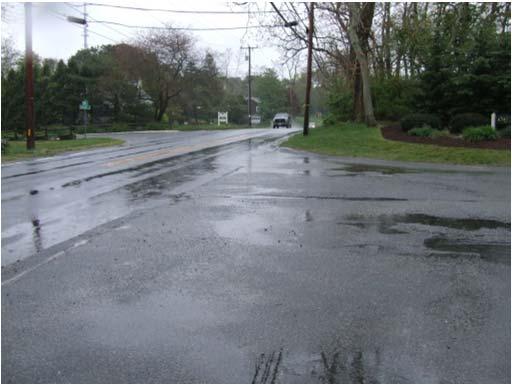
17 Priority Site Photos Area 1 Crosby Area 2 Nickerson entrance Area 3 Holly Ave


18 Priority Site Photos Area 4 Old Layout Area 6 Bakers Pond Rd/BayRidge Area 5 Old Layout Orl/Brew Industrial


19 Priority Site Photos Area 7A Underground Mall-Underpass/East Area 8 Owl Pond/Seaview Area 7B Underpass-Skaket/West Area 9 Vesper Pond

20 Developing a Site Evaluation Matrix Began with listing types of treatment for: Complete Streets Stormwater Context Sensitivity


21 Developing a Site Evaluation Matrix.and than evaluated suitability for siting each design type through site visits to priority site locations

22 Developing a Site Evaluation Matrix Final matrix provided guidance for creation of conceptual designs Too small to read? We brought copies!
23 Final Design Considerations

24 Getting to a Proposed Alternative by Developing Conceptual Plans Plans take into consideration: MassDOT sidewalk plans State and National best management practices Emerging technologies And also consider: Traditional Cape Cod character Ease of implementation
25 MassDOT Conceptual Sidewalk Plans (2010) Include connection to Nickerson End at Holly Traditional concrete/granite curbing On hold


26 Emerging Standards for Pedestrian Safety in High Traffic Areas Consulted transportation staff for difficult interchange Conceptual guidance for proposing future improvement Emerging practices and technologies Rectangular Rapid Flash Beacon?

27 Current Practices: Context Sensitive design Public support for NO GRANITE CURBS! Remember the history of 6A Meandering walk for careful attention to specimen trees and utility poles The goal: context sensitive, low impact pathways (like these in Yarmouthport)
28 Proposed Alternatives Crosby Lane Skaket Corners
29


30 Context sensitive curbing/ Rainwater harvesting A: Cape Cod Berm B: Sloped curb Rain Garden
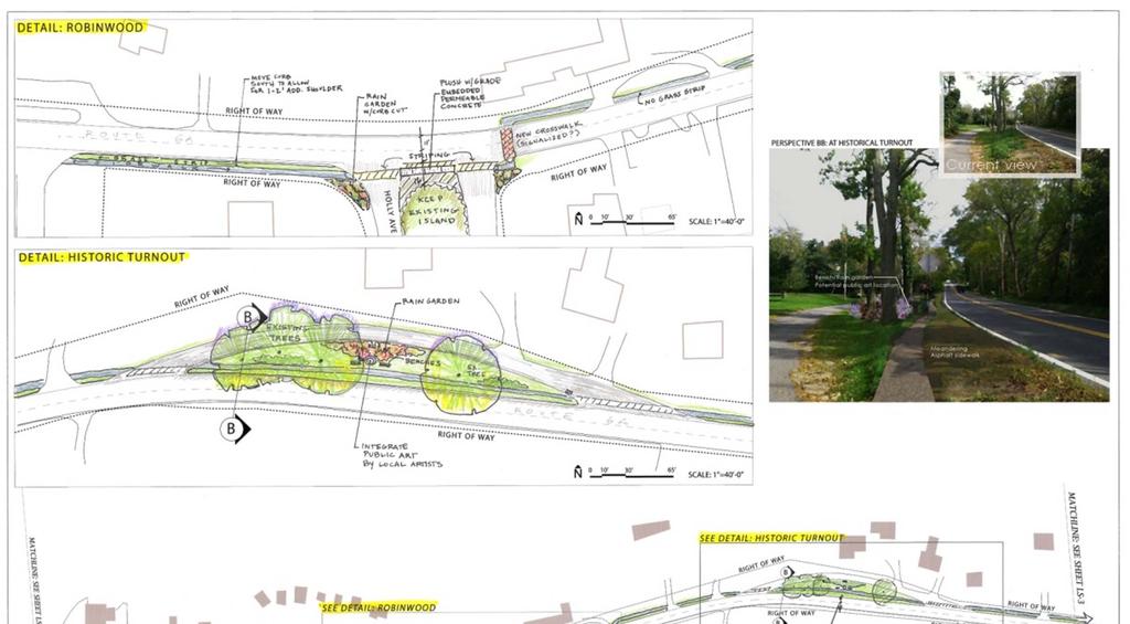
31


32 Current Public art location Proposed MONTH DAY YEAR
33

34 MONTH DAY YEAR

35


36 Current Proposed


37 We used to have Living Streets


38 We Can have Living Streets Again! Current Potential public space acts as gateway Proposed Meandering sidewalk provides sheltered pathway
39 Next Steps MassDOT reporting of preferred alternative Local buy-in Future study for JTC MP0 TIP OR phased implementation via small steps
40 We d like to hear from you -- Questions/Comments? Contact: Tabitha Harkin, LEED GA tharkin@capecodcommission.org Special Projects Coordinator (Landscape Design Specialist) Cape Cod Commission P.O. Box Main Street Barnstable, MA 02630
FDOT D4 Complete Streets
 FDOT D4 Complete Streets Context Sensitive Solutions Directs that complete street solutions will complement the context of the community. Collaborative approach to decision making, project development,
PLACEMAKING & MOBILITY WORKSHOP. January 27, 2016
 PLACEMAKING & MOBILITY WORKSHOP January 27, 2016 Boston needs more housing. But there is no one-size fitsall solution. Every neighborhood has its own character. In some places, density is not only appropriate
Tonight s Agenda. Summary Presentation Open House. Group Discussion Next Steps: online community wide survey
 Community Open House February 22, 2018 Tonight s Agenda Summary Presentation Open House Station 1: Project Overview and Community Input Station 2: Draft Vision and Guiding Principles Station 3: Western,
This page left intentionally blank.
 July 2012 This page left intentionally blank. Table of Contents Appendix A : Project Development Checklist Appendix B: At-Grade Rail Crossings Appendix C: Maintenance and Operations Examples Appendix D:
West Dennis Center: Bass River to Old Main Street. West Dennis Business District: Old Main Street to Dennis Commons
 West Dennis Center: Bass River to Old Main Street West Dennis Business District: Old Main Street to Dennis Commons Dennisport Center: Dennis Commons to Division Street Main Street Project Goals Project
Toronto Complete Streets Guidelines
 Toronto Complete Streets Guidelines 108 110 7.1 Green Infrastructure Design Principles 112 7.2 Context-Sensitive Green Streets 114 7.3 Key Green Street Elements Green infrastructure refers to natural and
SH 199 Corridor Master Plan. Community Meeting No. 2 May 31, 2017
 Community Meeting No. 2 May 31, 2017 Transportation Projects On or Near SH 199 SH 199 from 0.3 miles south of FM 1886 to south end of Lake Worth bridge Construct freeway mainlanes and frontage roads 10-Year
Urban Design 9Identity
 Urban Design 9Identity URBAN DESIGN IDENTITY Urban design is about connecting people to their places through the built environment, nature, and overall urban form. Done well, it creates a memorable space
Executive Summary. NY 7 / NY 2 Corridor
 Executive Summary NY 7 / NY 2 Corridor Transportation and Land Use Study December 2005 Prepared for: Town of Colonie Capital District Transportation Committee Prepared by: Introduction: Land use decisions
Potential Green Infrastructure Strategies May 6, 2015 Workshop
 Potential Green Infrastructure Strategies May 6, 2015 Workshop Background The City of Cortland is developing the Tioughnioga Urban Headwaters Green Infrastructure Action Plan with funding from the National
City of Farmington. Downtown Plan. Amendment to the 1998 Master Plan Adopted October 11, 2004
 City of Farmington Amendment to the 1998 Master Plan Adopted October 11, 2004 Introduction Planning Background 1 Scope and Components of the Plan Amendment 2 Concept Introduction 3 Plan Concepts 3 Conceptual
Old Town Neighborhoods Plan. Choices Event Wednesday, December 9, 2015
 Old Town Neighborhoods Plan Choices Event Wednesday, December 9, 2015 Agenda 6:00 6:10 p.m. Welcome + Sign In 6:10 6:30 p.m. Presentation 6:30 8:00 p.m. Workshop + Open House Seeking your input on: Neighborhood
Whitemarsh Comprehensive Plan Update: Housing & Land Use. Public Workshop #3: September 20, 2018
 Whitemarsh Comprehensive Plan Update: Housing & Land Use Public Workshop #3: September 20, 2018 Agenda Welcome Process Recap What We ve Heard The Plan Framework Review of Recommended Actions Land Use Housing
COMPLETE GREEN STREET CHECKLIST
 COMPLETE GREEN STREET CHECKLIST This document was developed to dissect the structure of an urban street and explore opportunities to make our streets more complete while also integrating green street strategies.
Project Overview. Get Involved. Public Information Meeting. Contact Information
 Get Involved VDOT representatives will review and evaluate information received as a result of this meeting. Please fill out the comment sheet provided in this brochure if you have any comments or questions.
The West Vaughan Employment Area Secondary Plan Policies
 Part 2: The West Vaughan Employment Area Secondary Plan Policies 2.1 General Policies It is the policy of Council: 2.1.1. That the West Vaughan Employment Area (the WVEA), identified on Schedule 1, will
City of Hermosa Beach Administrative Policy #
 City of Hermosa Beach Administrative Policy # SUBJECT: Living Streets Policy Date: Approved by: City Council Authority: Public Works Department & Community Development Department Mayor, PURPOSE The City
PLAN ELEMENTS WORKSHOP. April 5, 2016
 PLAN ELEMENTS WORKSHOP April 5, 2016 needs more housing. But there is no one-size fits-all solution. Every neighborhood has its own character. In some places, density is not only appropriate it is badly
Lambeth Main Street Streetscape Improvements
 Lambeth Main Street Streetscape Improvements Open House October 5th, 2017 Agenda 1. Introduction 2. Project Background 3. Context 4. Project Objectives 5. Design Principles & Approach 6. Streetscape Design
Monroe Street Reconstruction. Final Corridor Design Presentation & Open House August 16, 2017
 Monroe Street Reconstruction Final Corridor Design Presentation & Open House August 16, 2017 Thank you to Wingra School! Tonight s Agenda 1. Project Overview 2. Design Proposal & Preparing for Reconstruction
SCTPO Project Summary September 2014
 A1A MULTIMODAL CORRIDOR PLANNING AND ENGINEERING ANALYSIS Florida Department of Transportation SCTPO Project Summary September 2014 PRESENTATION FOOTER Meeting Agenda What We Plan To Do Project Background
Future Proposed Development
 Future Proposed Development on and around Link light rail s Capitol Hill Station Meeting September 24, 2012 Tonight s Agenda 6:00 pm Open House 6:30 pm Introductions Richard Conlin, City of Seattle Councilmember/Sound
Community Open House March 26 th, 2018
 Community Open House March 26 th, 2018 Open House Agenda 1. Overview of Planning Process What we heard 2. Future Land Use Policy 3. Priority Growth Areas 4. Plan Elements Making it happen What is a Comprehensive
Public Meeting May 20, 2014
 Public Meeting May 20, 2014 Overview Study Purpose Study Area Overview Strategies Potential Opportunities Implementation and Discussion Skeo Solutions Raleigh Walkable Watershed Pilot 2 Purpose Develop
University Parkway Corridor Plan. Public Workshop Sept. 18, 2017
 University Parkway Corridor Plan Public Workshop Sept. 18, 2017 AGENDA 1. Overview of Process 2. Study Area 3. Components of the Plan 4. What We Know 5. What We Have Heard 6. Tonight s Input 7. Next Steps
Getting Started On Your Green Infrastructure (GI) Plan
 Plan") Getting Started On Your Green Infrastructure (GI) Plan Peter Schultze-Allen EOA Inc. Annual SCVURPPP C3 Workshop June 16, 2015 Presentation Outline MRP 2.0 C.3.j (GI) requirements GI Framework elements
Getting Started On Your Green Infrastructure (GI) Plan Peter Schultze-Allen EOA Inc. Annual SCVURPPP C3 Workshop June 16, 2015 Presentation Outline MRP 2.0 C.3.j (GI) requirements GI Framework elements
Fifth and Detroit Street Design May 2017 Capital Improvements Committee. DOWNTOWN Street Design
 1 Fifth and Detroit Street Design May 2017 Capital Improvements Committee Agenda 2 Review Street Configuration Prior Meeting Review Outreach Synopsis Functional Street Design Refinements Curb Edge, Turning
RIVERSIDE, Newton MA June 9, 2011
 June 9, 2011 TONIGHT S AGENDA: 1.Project Update (5 min.) 2.Master Plan Update (10 min.) 3.Environmental Update (5 min.) 4.Traffic Plan Update (25 min.) Questions PROJECT STATUS UPDATE Responding / Clarifying
Scope of Services. River Oaks Boulevard (SH 183) Corridor Master Plan
 Corridor Master Plan") Scope of Services River Oaks Boulevard (SH 183) Corridor Master Plan PROJECT AREA The project area consists of the River Oaks Boulevard (SH 183) corridor bounded by SH 199 at the northern end and the Trinity
Scope of Services River Oaks Boulevard (SH 183) Corridor Master Plan PROJECT AREA The project area consists of the River Oaks Boulevard (SH 183) corridor bounded by SH 199 at the northern end and the Trinity
TORONTO COMPLETE STREETS GUIDELINES
 TORONTO COMPLETE STREETS GUIDELINES Presentation by Fiona Chapman, Manager, Pedestrian Projects Public Realm Section, Transportation Services, City of Toronto June 2017 PURPOSE OF THE PROJECT To develop
Route 347. New York State Department of Transportation Region 10, Long Island. THE GREENING of ROUTE 347
 The GREENING of Route 347 The Greening of Route 347 The Greening of Route 347: History 3 The Greening of Route 347 4 The Greening of Route 347 5 The Greening of Route 347 Smith Haven Mall 6 The Greening
SCOTT P. GOODSON, DEVELOPMENT SUPERVISOR, CHICK-FIL-A, INC BUFFINGTON ROAD, ATLANTA, GA
 MEMORANDUM TO: FROM: SUBJECT: SCOTT P. GOODSON, DEVELOPMENT SUPERVISOR, CHICK-FIL-A, INC. 5200 BUFFINGTON ROAD, ATLANTA, GA 30349-2998 CAPE COD COMMISSION STAFF CHICK FIL A RESTAURANT PROPOSAL, HYANNIS,
3.0 master plan concept
 3.0 master plan concept 3.1 introduction The purpose of the Huron Church Road Master Plan Concept is to provide an overview of the Master Plan design process, identify preliminary streetscape installations
Monroe Street Reconstruction. Business Roundtable March 29, 2017
 Monroe Street Reconstruction Business Roundtable March 29, 2017 Thank you to HotelRED and Roman Candle Pizza! Tonight s Agenda 1. Monroe Street Business Strategy Overview 2. Reconstruction Project Scope
Coffee Creek Park Development Low Impact Development (LID)
") Coffee Creek Park Development Low Impact Development (LID) City of Duluth, St. Louis County, MN Presented By: Christopher J. Rousseau, P.E. February 27, 2008 Developer / Owner Information Trinity Development
Coffee Creek Park Development Low Impact Development (LID) City of Duluth, St. Louis County, MN Presented By: Christopher J. Rousseau, P.E. February 27, 2008 Developer / Owner Information Trinity Development
COMMUNITY DESIGN. GOAL: Create livable and attractive communities. Intent
 COMMUNITY DESIGN Intent An attractive, well-designed County will attract quality development, instill civic pride, improve the visual character of the community, and create a strong, positive image for
Low Impact Development in Coastal South Carolina: A Planning and Design Guide
 Low Impact Development in Coastal South Carolina: A Planning and Design Guide ACE Basin & North Inlet-Winyah Bay National Estuarine Research Reserves Network of 28 Reserves NOAA Program Research, Stewardship,
Garden District Heritage Conservation District Study
 Garden District Heritage Conservation District Study Community Consultation Meeting Ryerson International Living & Learning Centre 7:30 9:00 pm April 29 th, 2014 Presentation Overview Presentation of project
Agenda. Introductions and Overview Study Purpose Study Approach Key Analysis Components Study Context Development Activity ( )
") October 5, 2017 Agenda Introductions and Overview Study Purpose Study Approach Key Analysis Components Study Context Development Activity (2005-2017) Existing Conditions Alternatives Public Engagement
October 5, 2017 Agenda Introductions and Overview Study Purpose Study Approach Key Analysis Components Study Context Development Activity (2005-2017) Existing Conditions Alternatives Public Engagement
CHAPTER 8. Mrs. Zimman s Class - Central Elementary
 SUSTAINABILITY CHAPTER 8 Mrs. Zimman s Class - Central Elementary 8.1 OVERVIEW Green infrastructure also known as low impact development (LID) and environmental or sustainable site design is an environmentally
Route 1 Corridor Study
 Route 1 Corridor Study Westbrook, Connecticut A Vision for the Connecticut Shoreline Public Informational Meeting July 28, 2015 Lower Connecticut River Valley Council of Governments Fitzgerald & Halliday,
SOUTH UNIVERSITY Street Design Setting a Direction for Schematic Design
 1 SOUTH UNIVERSITY Street Design Setting a Direction for Schematic Design Meeting Agenda 2 1. Project Scope 2. Design Direction 3. Design Details 4. Schedule and Construction Logistics 3 SOUTH UNIVERSITY
US-10/US-31 Corridor Planning Charrette Summary. Resilient Ludington Mason County, Michigan
 US-10/US-31 Corridor Planning Charrette Summary Resilient Ludington Mason County, Michigan Plan Prepared By Resilient Ludington Participating Units of Government: Mason County City of Ludington Pere Marquette
Transportation. Strategies for Action
 Transportation A major priority for the Overlake Neighborhood is to develop a multimodal transportation system. To achieve this system, a balance has to be found among travel, circulation and access needs;
Elderberry, Pioneer, Junction
 February 15, 2018 Pioneer Road Pioneer Mineral Point Road Elderberry Pleasant View Road Junction Junction Road Agenda Recap of Background Information, Open House #1 Draft Neighborhood Development Plan
Richmond Road Complete Street Meeting #1, April 25, 2016
 Richmond Road Complete Street Meeting #1, April 25, 2016 Agenda Overview Richmond Road Complete Street Other Ongoing Studies Discussion Map buses/day removed from Sir John A. Macdonald Parkway Confederation
McCowan Precinct Plan Study Background & Deliverables
 1 DRAFT & WITHOUT PREJUDICE McCowan Precinct Plan Study Background & Deliverables In September, 2011, City Planning (Scarborough District) began a study of an area within the Scarborough Centre, identified
Eastside Transit Corridor Phase 2 Technical Study Update Community Outreach Meeting February 2017
 Eastside Transit Corridor Phase 2 Technical Study Update Community Outreach Meeting February 2017 Purpose of Tonight s Meeting Recap of Board motion (2014) and technical study process Provide update on
The transportation system in a community is an
 7 TRANSPORTATION The transportation system in a community is an important factor contributing to the quality of life of the residents. Without a sound transportation system to bring both goods and patrons
Goals for Tonight s Meeting
 South Anthony Boulevard Railroad Grade Separation Study Report to Community November 30, 2011 Andorfer Commons Theatre Indiana Tech University Goals for Tonight s Meeting Recap of the meeting from last
2.5 Roads. Loading and service areas adjacent to Highway 401 should be screened through architectural walls and/or landscape buffer planting.
 N HIGHWAY OFF RAMP 2.5 Roads A legible road network with a clear hierarchy will help create a connected community, both within and surrounding the Milton Heights. The following section outlines the proposed
Community Design Guidelines. Port Wallace DRAFT
 Community Design Guidelines Port Wallace DRAFT Energy 1 2 3 Nature Movement Connections Built Form DRAFT Layout Energy 1 Nature Community Design Guidelines GREAT COMMUNITIES PROTECT, CELEBRATE, AND CONSERVE
Clovis Urban Greening Plan. Community Workshop #2 Northwest
 Clovis Urban Greening Plan Community Workshop #2 Northwest Thursday, October 9, 2014 WHAT IS AN URBAN GREENING PLAN? A guide to help the City to improve quality of life for residents Identification of
Rapid Transit Implementation Working Group
 Rapid Transit Implementation Working Group October 12, 2017 1 Agenda 1. Consultation Update 2. Technical Work Update 3. LTC Rapid Transit Integration 4. Next Steps 2 Consultation Update 3 Consultation
Adelaide Street / Canadian Pacific Railway (CPR) Grade Separation Class Environmental Assessment. Public Information Centre 3
 Grade Separation Class Environmental Assessment. Public Information Centre 3") 1 Adelaide Street / Canadian Pacific Railway (CPR) Grade Separation Study Process and Purpose of PIC 3 2 Study Commencement February 2016 Phase 1: Problem and Opportunity Identify problems and opportunities
1 Adelaide Street / Canadian Pacific Railway (CPR) Grade Separation Study Process and Purpose of PIC 3 2 Study Commencement February 2016 Phase 1: Problem and Opportunity Identify problems and opportunities
DRAFT. October Wheaton. Design Guidelines
 October 2011 DRAFT Wheaton Design Guidelines 2 Draft - Design Guidelines - Wheaton Sector Plan Contents 04 Section 1: Introduction 06 Section 2: Context 08 Section 3: Design Guidelines 09 Goal 1: Create
124 Subarea Visions. Vision Plan. A. Nelessen Associates, INC I Visioning I Planning I Urban Design
 Subareas 124 Subarea Visions The next seven sections describe specific recommendations tailored to each subarea. Each subarea is discussed separately except for certain aspects of 95th Street and Antioch
Public Hearing. Charlotte County-Punta Gorda MPO - Meeting Rooms A and B March 14, open house at 4 p.m., formal presentation at 5 p.m.
 Public Hearing Charlotte County-Punta Gorda MPO - Meeting Rooms A and B March 14, 2019 open house at 4 p.m., formal presentation at 5 p.m. Welcome to the Public Hearing for the Harborview Road (CR 776)
Route 5 Corridor Land Use and Transportation Plan
 N Y S M P O Integrated Transportation Planning & Community Design Processes ALBANY Great streets do not just happen... They are streets for both pedestrians and drivers. They have definition, a sense of
Bethlehem Pike Streetscape Master Plan
 Bethlehem Pike Streetscape Master Plan Prepared for Springfield Township October 2008 By Michael Baker Jr., Inc. Carter Van Dyke Associates Table of Contents 1. Introduction 3 2. General Corridor Wide
Seneca Meadows. Block 4 Locate office, technology, and medical development adjacent to I Screen views of garage structures from I-270.
 Seneca Meadows Seneca Meadows has an industrial park in its southern end and a mixed-use employment area planned for the north end. The district benefits from extensive I-270 visibility, stream valley
Red Fox Commercial Outline Plan
 Red Fox Commercial Outline Plan City of Cold Lake, Alberta Prepared by Durrance Projects Ltd and Ross W. Sharp & Associates Ltd October 2014 Rupert 1 Table of Contents 1. PURPOSE...3 1.1. Location...4
Waverley West B Secondary Planning Process. Open House South Pointe School April 25, 2018
 averley est B Secondary Planning Process South Pointe School April 25, 2018 averley est B Secondary planning process open house Please review the boards and provide your feedback. 1 The Role of a Secondary
MALLETTS BAY INITIATIVE
 MALLETTS BAY INITIATIVE Stormwater Management & Transportation Scoping Study January 19, 2017 Project Team Bryan Osborne Director of Public Works Sarah Hadd Director of Planning & Zoning Marshall Distel
Derry Green Corporate Business Park
 Town of Milton Derry Green Corporate Business Park Urban Design Guidelines BMI/Pace - June 2010 Draft 3 Prepared by: Brook McIlroy Planning + Urban Design / Pace Architects Suite 300-51 Camden Street Toronto,
PINE CURVE REZONING. Property does not meet criteria for open space preservation and is not a candidate for a park
 PINE CURVE REZONING BACKGROUND Purchased as two parcels in 2001 and 2002 Annexed and Zoned Greater Downtown District Historic Center September 25, 2002 and October 7, 2002 WHAT THE PROJECT IS AND IS NOT
The George Washington University Streetscape Concept Plan. May 6 th 2009 Public Presentation for Discussion EHRENKRANTZ ECKSTUT & KUHN ARCHITECTS
 The George Washington University Streetscape Concept Plan May 6 th 2009 Public Presentation for Discussion EHRENKRANTZ ECKSTUT & KUHN ARCHITECTS Agenda 1. Introduction & Overview 2. Background & Context
Pine Island Road Corridor Master Plan
 RECOMMENDED DEVELOPMENT PLAN Figure 9: Del Prado Village District Conceptual Framework The Conceptual Framework (Figure 8) for development of the Pine Island Corridor is to encourage mixed-use development
Clay Street Bridge Replacement Project
 Clay Street Bridge Replacement Project Frequently Asked Questions (FAQs) No. 2 April 4, 2018 The project is located in downtown Placerville on Clay Street between US Highway 50 and Main Street and Cedar
Sidewalks Street Lights
 Boston Complete Streets Guidelines 013 Boston Transportation Department Sidewalks Introduction 17 Sidewalk Design Principles 18 Sidewalk Zones 0 Sidewalk Zones Widths Preferred and Minimum Widths for Sidewalk
Presentation August 6, 2018
 Steering Committee Meeting #4 Presentation August 6, 2018 1 A. Commercial Strip Development and Alternatives B. Public Kick-off Meeting C. Next Steering Committee Meeting Road Map of Planning Process 2
Study Area. Capitol Way. Greening America s Capitals 11/13/2014. A Greening America s Capitals Project
 Olympia, WA: Greening Capitol Way Supporting Communities move towards sustainability is a priority for the federal government. A Greening America s Capitals Project Office of Sustainable Communities U.S.
Charles P. Johnson and Associates. Annapolis Landscape Architects
 Charles P. Johnson and Associates Annapolis Landscape Architects AGENDA Introduction Project Limits and Scope Site Analysis Opportunities & Constraints Program Goals Image Boards Design Alternatives Pros
BEST PRACTICES FOR PROJECT NOMINATIONS TA Set-Aside Program
 BEST PRACTICES FOR PROJECT NOMINATIONS 2017 TA Set-Aside Program Focus of this presentation Photos Public Support Maps & Exhibits Proposed Budget Design Details Project Evaluation & Selection Criteria
Workshop #3 June 13, 2016
 Downtown Ocoee Master Plan Workshop #3 June 13, 2016 Our Team Our Team and Tonight s Goal Quick Recap: Why a Downtown Plan? How are we developing the plan? How can you still be involved? What s left to
Incorporating Sustainable Practices and Water Quality into Roadway Design. May 24, 2017
 Incorporating Sustainable Practices and Water Quality into Roadway Design May 24, 2017 Justin Oswald, P.E., CFM Freese and Nichols, Inc. Presenters Todd Buckingham, P.E., ENV SP Freese and Nichols, Inc.
Description of Preferred Alternative
 Chapter 2 Description of Preferred Alternative 2.1 Introduction This chapter of the programmatic Sammamish Town Center Sub-area Plan Final EIS provides a more detailed description of the Preferred Alternative
The Illinois Department of Transportation and Lake County Division of Transportation. Route 173, including the Millburn Bypass
 The Illinois Department of Transportation and Lake County Division of Transportation welcome you to this Public Hearing for U.S. Route 45 from Illinois Route 132 to Illinois Route 173, including the Millburn
Subregion 4 Central Avenue-Metro Blue Line Corridor Transit-Oriented Development (TOD) Implementation Project. Community Meeting April 27, 2011
 Implementation Project. Community Meeting April 27, 2011") Subregion 4 Central Avenue-Metro Blue Line Corridor Transit-Oriented Development (TOD) Implementation Project Community Meeting April 27, 2011 Overview Introduction to Subregion 4 TOD Implementation Program
Subregion 4 Central Avenue-Metro Blue Line Corridor Transit-Oriented Development (TOD) Implementation Project Community Meeting April 27, 2011 Overview Introduction to Subregion 4 TOD Implementation Program
Highway 12 Sibley Avenue Reconstruction. Project Overview and Progress To Date Litchfield City Council April 17, 2017
 Highway 12 Sibley Avenue Reconstruction Project Overview and Progress To Date Litchfield City Council April 17, 2017 Agenda Item Topic 1) Project Purpose and Need 2) Key Recommendations from Study 3) Preliminary
Introduction. Chapter 1. Purpose of the Comprehensive Plan Plan Organization Planning Process & Community Input 1-1
 Chapter 1 Introduction Lakewood 2025: Moving Forward Together Purpose of the Comprehensive Plan Plan Organization Planning Process & Community Input 1-1 Purpose of the Comprehensive Plan The Comprehensive
Crazylegs Plaza & Wingra Park Entrance: Mosaic Art Input Session. November 8, 2017
 Crazylegs Plaza & Wingra Park Entrance: Mosaic Art Input Session November 8, 2017 Thank you to HotelRED! Agenda 1. Project Overview Team and scope Public art context Approved site designs & input to-date
Hockessin Community Redevelopment Plan
 Hockessin Community Redevelopment Plan 3.1 Introduction The Community Redevelopment Plan for the Village of Hockessin is the result of the people s vision for a distinct village center that serves as the
MAIN STREET DESIGN GUIDELINES CONTEXT
 MAIN STREET DESIGN GUIDELINES CONTEXT VISION The re-imagining of Main Street offers an unparalleled opportunity to strengthen and link Fredericton North through the integration of local neighbourhoods,
open house 3 CITY OF SALEM Downtown Streetscape Plan
 open house 3 Streetscape concepts CITY OF SALEM Downtown Streetscape Plan analysis concepts we are here refined concepts & document Feb 13th 1 2 3 apr 18th KICKOFF OPEN HOUSE Streetscape Work Group Walking
Town Center (part of the Comprehensive Plan)
") Town Center (part of the Comprehensive Plan) Mercer Island Town Center Looking North (2014) In 1994, a year-long process culminated in a set of design guidelines and code requirements for the Town Center
Town Center (part of the Comprehensive Plan) Mercer Island Town Center Looking North (2014) In 1994, a year-long process culminated in a set of design guidelines and code requirements for the Town Center
master plan of highways bus rapid transit amendment
 Scope of Work master plan of highways bus rapid transit amendment September 2011 Montgomery County Planning Department M-NCPPC MontgomeryPlanning.org 1 Scope of Work master plan of highways bus rapid transit
Portage Parkway Environmental Assessment Public Information Centre No. 1
 City of Vaughan Portage Parkway Environmental Assessment Public Information Centre No. 1 November 25, 2015 Welcome to the Public Information Centre This first Public Information Centre (PIC) introduces
Maplewood Avenue Downtown Complete Street Project
 Maplewood Avenue Downtown Complete Street Project Second Public Meeting January 24, 2018 Welcome and Introduction of Project Team City Planning and Public Works Staff City of Portsmouth Juliet Walker Planning
Downtown Streetscape Manual & Built Form Standards
 City of Guelph Downtown Streetscape Manual & Built Form Standards July 2014 Prepared by Brook McIlroy Inc. in association with Unterman McPhail Associates and McCormick Rankin Inc. City of Guelph Downtown
Planning Board Briefing
 Planning Board Briefing Why Now? The Sector Plan Implementation Chapter States: Before Stage 1 begins, the following must occur: Approval of the Sectional Map Amendment. Approval of the Greater Lyttonsville
YARMOUTH ARCHITECTURAL AND SITE DESIGN STANDARDS
 YARMOUTH ARCHITECTURAL AND SITE DESIGN STANDARDS Photos of South Yarmouth Village from the Collection of Gloria Smith Date Adopted by the Planning Board: August 16, 2006 Revised to: January 19, 2011 TABLE
Appendix E: Illustrative Green Infrastructure Examples
 Appendix E: Illustrative Green Infrastructure Examples Integrating LID into San Francisco s Urban Landscape Figure E. High-density Residential Figure E. Low-density Residential Figure E. Mixed Use 7 Figure
5.1.1 The streetscape along US Highway 64 (Brevard Road); and, The built environment within new residential developments; and,
; and, The built environment within new residential developments; and,") Article 5. Landscaping 5.1 Purpose The Town of Laurel Park s landscape standards are designed to create a beautiful, aesthetically pleasing built environment that will complement and enhance community
Article 5. Landscaping 5.1 Purpose The Town of Laurel Park s landscape standards are designed to create a beautiful, aesthetically pleasing built environment that will complement and enhance community
Tennessee Stormwater Management Program. Stormwater Management Site Assessment and Inventory Checklist. Quick Check o Vicinity Map within Watershed
 Tennessee Stormwater Management Program Project Name: Location: File Number: Reviewer: Date of Submittal: Review Date: Project Meeting Chronology: Type of Meeting: Date: Stormwater Management Site Assessment
Anderson Memorial Bridge Rehabilitation Project Boston/Cambridge
 Anderson Memorial Bridge Rehabilitation Project Boston/Cambridge MEPA Meeting, EEA#14702 Wednesday, March 2, 2011 6:30 PM Dr. Martin Luther King, Jr. School 100 Putnam Avenue, Cambridge, MA Rendering by:
CITY OF CHARLOTTESVILLE, VIRGINIA CITY COUNCIL AGENDA
 CITY OF CHARLOTTESVILLE, VIRGINIA CITY COUNCIL AGENDA Agenda Date: December 16, 2013 Action Required: Adoption of Resolution Presenter: Staff Contacts: Title: James E. Tolbert, AICP, Director of NDS James
Rapid Transit Implementation Working Group September 14, 2017
 Rapid Transit Implementation Working Group September 14, 2017 BACKGROUND Council approved the Rapid Transit Master Plan and Updated Business Case on July 25, 2017. Approval of the RTMP confirmed the BRT
REVIEW AND EVALUATION OF REGIONAL LAND USE
 REVIEW AND EVALUATION OF REGIONAL LAND USE AND TRANSPORTATION SCENARIOS #220831 Environmental Justice Task Force October 7, 2014 VISION 2050 Process Development of Guiding Vision for Land Use and Transportation
Town of Chapel Hill. Prepared By: A Division of Pennoni. Chapel Hill, NC (919) Firm License: F-1267.
 Firm License: F-1267.") 401 Providence Road Suite 200 Chapel Hill, NC 27514 T: 919-929-1173 F: 919-493-6548 Firm License #: F-1267 www.pennoni.com Town of Chapel Hill Orange County, North Carolina STATEMENT OF COMPLIANCE Prepared
401 Providence Road Suite 200 Chapel Hill, NC 27514 T: 919-929-1173 F: 919-493-6548 Firm License #: F-1267 www.pennoni.com Town of Chapel Hill Orange County, North Carolina STATEMENT OF COMPLIANCE Prepared