TREC-RMC Final Report:
|
|
|
- Francine Melton
- 5 years ago
- Views:
Transcription

1 TREC-RMC Final Report: Land Cover Classification from Digital Color-Infrared Aerial Photos and GIS Parcel Database Maintenance In the Frog Pond Principal Investigator: Rafael Muñoz-Carpena, Assistant Professor of Hydrology and Water Quality, TREC-University of Florida Collaborator: Karen Minkowski, GIS Specialist, TREC-University of Florida Submitted to the South Dade Soil and Water Conservation District May 6, 2003
2 Executive Summary The Frog Pond Agricultural Area is a mixed land use region in southern Miami-Dade County. It shares its western border with Everglades National Park. A classification of the vegetation/land cover in the Frog Pond was requested by the South Dade Soil and Water Conservation District (SDSWCD) in order to establish a baseline from which to compare and interpret changes that may be related to hydrological and structural modifications being implemented by the federal government in the Everglades restoration effort. Classification was performed on an aerial infrared color photograph of the Frog Pond using Erdas Imagine 8.5. The vegetation associations, or habitats, were organized into six native, characteristically Everglades habitats, and three disturbed. Of the total 5,385 acres in the Frog Pond, 502 fell into the native habitats, and 1,174 into disturbed habitats. Together these comprise thirty-one percent of the total land area of the Frog Pond. Cattail, often an indicator of excess phosphorous in the Everglades, covers approximately forty-four acres; Elephant grass, an exotic invasive species, covers a minimum of 297 acres. We found no exotic species not mentioned in a 2000 report by the Center for Aquatic and Invasive Species. A second aspect of the study was to update the Geographic Information Systems database of land use that had been generated in Changes to the database were made using Arc/Info 8.1 and ArcView 3.2. A total of 377 acres in four leased agricultural parcels was removed from agriculture and became part of the Detention Pond. Erdas is very useful for its powerful unsupervised classification functions, although the user must make often difficult decisions about which resulting classes to combine. The suite of ESRI tools available in Arc/Info and ArcView provide flexibility, ease of vector editing and display and overlay capabilities. Bi-annual follow up studies are urged in order to understand the results of these modifications in the Frog Pond and also to provide a model for how to approach habitat change resulting from similar modifications elsewhere.
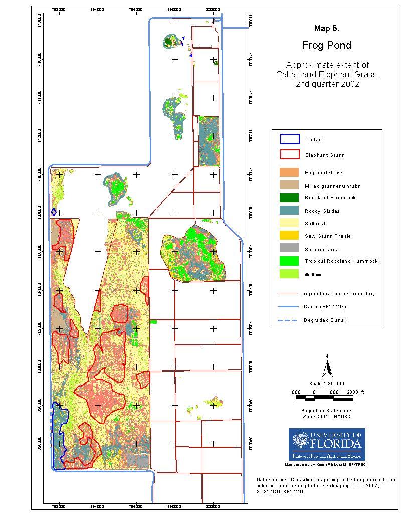
3 Table of Contents 1. Introduction 1 2. Objectives 2 3. Methods 3 4. Results and Discussion 5 5. Conclusions 8 6. Acknowledgements 9 7. References 9 Appendix 1. Scientific Names of Plants Identified in the Frog Pond 11 Appendix 2. Maps 12 Map 1. Land Cover, Infrared Aerial Photograph, 2 nd quarter 2002 Map 2. Land Cover, Digitized, 2 nd quarter 2002 Map 3. Habitat Polygons Map 4. Land Cover, Classified, 2 nd quarter 2002 Map 5. Approximate Extent to Cattail and Elephant Grass, 2 nd quarter 2002 Map 6. Land Use, January July 2003
4 1. Introduction The Frog Pond Agricultural Area covers 5,385 acres in southern Miami-Dade County and shares its western border with Everglades National Park. Work is under way by the South Florida Water Management District (SFWMD) and the Army Corps of Engineers to implement hydrological and structural modifications in the Frog Pond as part of the federally authorized Comprehensive Everglades Restoration Program (CERP) and the Interim Operational Plan (IOP) for Protection of the Cape Sable Seaside Sparrow. The modifications in the Frog Pond were designed to restore fresh water flow to Taylor Slough, which originates in the western part of the Frog Pond and continues into Everglades National Park, and are part of an overall effort to restore the hydroperiods in the Everglades marshes. These changes are expected to affect vegetation cover in the Frog Pond. While the specific results of these altered water levels and timing of water deliveries are currently being studied by our group as well as others, it is expected that hydrophilic plant cover will increase as water levels rise and that the sustainability of other land uses in the Frog Pond may be affected. A classification of the vegetation/land cover as of 2002 was requested by the South Dade Soil and Water Conservation District (SDSWCD) in order to establish a baseline from which to compare and interpret vegetation changes that may be related to these modifications. As the study proceeded, it was decided to estimate the coverage of cattail and elephant grass, as indicators, respectively, of high nutrient levels in the soil and of an invasion by an exotic species. A Geographic Information Systems (GIS) database of land use in the Frog Pond was created in 2001 under contract between the SDSWCD and TREC. This layer contains information on leased agricultural parcels provided by the SDSWCD and was constructed from existing GIS layers obtained from the SFWMD and Miami-Dade County s Information Technology Department (ITD). This database needed to be updated to reflect changes both in land uses, as well as in the gross land cover resulting from the hydrological and structural modifications. In February 2003, the USGS provided Lidar elevation data for the C-111 drainage basin in shapefile format. This included more than 65,000 elevation points that fall within the Frog Pond s boundaries. (Previously available Lidar elevation data for this area consisted of contour lines which contain less detailed information than the points.) These new data were to be examined together with the resulting habitat classes. Prior to this study, the Center for Aquatic and Invasive Plants (2000) completed a detailed examination of the invasive plants of the Frog Pond
5 2. Objectives 1) To classify and quantify the current vegetation structure in the Frog Pond, at the habitat level, and other land use cover in the Frog Pond. 2) To update and maintain the GIS database of land use, as well as overlay it with GIS layers that derive from the land cover classification study as well as with the Lidar elevation data.
6 3. Methods 3.1. Classification of land cover The South Dade Soil and Water Conservation District contracted with GeoImaging, LLC for digital color-infrared aerial photography of the Frog Pond. Overflights were conducted on February 18 and April 4, 2002, and the mosaic image delivered to TREC results from these two separate dates (Map 1). The four image bands are blue, green, red and infrared (near); blue, green and infrared (rather than red) were chosen for the analysis, as the infrared band shows vegetation in reds. The images are registered to the Florida State Plane Coordinate system (NAD83) with a pixel size (resolution) of three feet. The photograph was classified using the computer package Erdas Imagine 8.5. Ground referencing was performed to ensure as accurate a classification as possible. Following a visit to the Frog Pond with Joy Klein, Forest Restorationist and Education Coordinator at DERM, it was decided to classify the native plant associations into the following six Everglades habitats: Rocky Glades This habitat is characterized by abundant saw grass with frequent small clusters of native hardwood trees and/or individual trees. Poisonwood and willow bustic are common colonizing trees in the Rocky Glades, which, if left unburned, could develop into a poisonwood hammock. Lower stature grasses, including white-topped sedge, are also abundant. Sabal palm is in evidence. Rockland Hammock These hardwood hammocks are distinguished from Tropical Rockland Hammocks by the presence of live oak trees. Other important trees include willow bustic, poisonwood, strangler fig, and gumbo limbo. Saw Grass Prairie Saw grass, with other, lower stature grasses, dominates the relatively unbroken expanse of Prairie, with an occasional small cluster of, or individual, hammock trees and/or sabal palm. Slough Taylor Slough, one of two major sloughs in Everglades National Park, begins in the Frog Pond. Cattails dominate, with some willows and saw grass. Willow Head Willow is generally the only mature tree in these low-lying islands and is often surrounded by cattail, saw grass and one of several water-loving plants, possibly southern blue flag (Iris virginica). Tropical Rockland Hammock This type of hardwood hammock is nearly identical to the Rockland Hammock but lacks live oak. Although it was known that some very disturbed, non-agricultural areas occur in the Frog Pond, their characteristics were not known until the study was undertaken. These are described in Results and Discussion.
7 The minimum habitat size in this study is 0.25 acres. Habitats less than 0.25 acres were included in the surrounding vegetation. Appendix 1 lists the scientific names of all plant species mentioned in this report. To begin the classification procedure, a set of Areas of Interest (AOI s: polygons enclosing target areas) was digitized on the image around vegetation other than agricultural. These include both natural and exotic vegetation. The classification was conducted only on this vegetation, not on agriculture. An unsupervised (computer generated) classification was performed, with a specified set of 70 classes. These classes were then grouped based upon three types of reference information: 1) the discernible patterns in the original photograph; 2) the signatures statistical proximity (a signature is a group of pixels from the original image that the computer has combined into one class based on its spectral properties); and 3) eight ground-referencing visits to the Frog Pond between September 2002 and April During these visits, GPS coordinates were recorded with a Garmin 76, and maps of the area were annotated to clarify the nature of the vegetation at specific areas. Classes which appeared to be fairly well dispersed and/or could not be precisely assigned to another class were reduced to an insignificant size by Erdas Neighbor function, which permits the computer to assign pixels of the target class to a new class based upon its neighboring pixels. As familiarity with the Frog Pond s habitats increased, and the classification was yielding clearer habitat divisions, polygons were digitized in Arc/Info 8.1 over the aerial photo with constant reference to the final classified image to provide a GIS layer of these habitats. When the classification was nearly complete, the coverage of cattail and elephant grass were digitized. All maps included in this report were composed in ArcView The GIS database The coordinates of the original parcel database were adjusted to the color infrared photograph purchased by the SDSWCD from GeoImaging, LLC, using Arc/Info and ArcView. The Detention Pond, an area scraped bare by the Army Corps of Engineers to serve as a water-holding area, was digitized from the aerial photo and the resulting polygon overlaid on the updated land use layer.
8 4. Results and Discussion 4.1. Classification of land cover The native and disturbed, non-agricultural habitats together cover 1,676 acres, thirty-one percent of the Frog Pond s 5,385 acres. Table 1 summarizes the results of the classification process. Map 2 shows the spatial distribution of these habitats as digitized. Map 3 is an acetate overlay on which are plotted the outlines of these digitized habitats; when overlaid on the classified image, Map 4, one can see some of the variability within each habitat Native Habitats All areas in the Frog Pond show some evidence of disturbance by exotic invasive plant species. In the north, the exotic Burma reed grows along hammock edges where soil has accumulated to form a slight berm. The occasional Brazilian pepper is seen in the Rocky Glades. Elephant grass abounds in the disturbed western block of the Frog Pond, including near Hammocks. Among the many unidentified lower-stature grasses seen growing in the Rocky Glades, it is likely that some of these are exotics as well. Nevertheless, the six native habitats identified in this study are essentially intact. Rockland Hammock, of which three were identified, occurs only in the northern part of the Frog Pond. The most extensive hammock, a Tropical Rockland Hammock of forty-four acres, lies in the center of the Frog Pond. There are many Willow Heads throughout the Frog Pond and stretches of Willow are found on the western half of the western block. Rocky Glades occurs in patches surrounding most of the hammocks and a small, remnant patch of Saw Grass Prairie is found in the center. Finally, the Slough emerges in the southern corner of the western block Disturbed areas The following three disturbed categories were derived from the classification and field observations: Disturbed: Chinaberry The only area on the eastern side of the Frog Pond to be labeled Disturbed is a small tree island dominated by the exotic invasive tree, chinaberry; the island is bounded at least on its north edge, where the soil is a little higher, by elephant grass. The most disturbed sector of the Frog Pond is the western block, the area framed by the turns in the L-31W canal and the berm running down the center of the Frog Pond. This block was probably farmed many years ago after rock-plowing the original Rocky Glades. In the aerial photo (Map 1) one can discern some man-made patterns in the form of vertical striations in the landscape, for example, along the central western portion of this block where willow grows in strips, as though planted. Signs of former plowing may be discerned at about W and N. Fifty-one acres of relatively undisturbed native Tropical Rockland Hammocks are found in this block, mostly in the northeastern part, and patches of Rocky Glades occur throughout, as do Willow and Willow Head. Two disturbed classes are described for this part of the Frog Pond. 1
9 Table 1. Types and Acreages of Frog Pond s Non-agricultural Habitats Acres Major Native spp. MajorExotic spp. Native/Less Disturbed Rocky Glades 281 saw grass, poisonwood, willow bustic, white topped sedge, sabal palm Brazilian Rockland Hammock 4 live oak, poisonwood, wax myrtle, willow bustic, sabal palm, strangler fig, elderberry, gumbo limbo, trema, tetrazygia, bay (red?/swamp?), muscadine grape, Boston fern pepper Burma reed Saw Grass Prairie 6 saw grass, poisonwood or other typical hammock tree, lower-stature grasses Slough 51 saw grass, cattail, willow elephant grass Willow Head 7 willow, cattail, saw grass, southern blue flag (?) Tropical Rockland 153 all species that are found in Rockland Hammock, except live oak; slash pine Hammock Total acres of Native 502 Disturbed Disturbed:Chinaberry 2 chinaberry elephant grass Disturbed:Mixed 1,017 saltbush, willow, cattail, occasional hammock tree spp. elephant grass Scraped: Recolonizing 16 not visited, hammock tree spp. seen along edges Willow 139 willow, saltbush, saw grass, elephant grass Total acres of Disturbed 1,174 Total acres 1,676 2
10 Disturbed: Mixed The most common plants are the native saltbush and the exotic invasive elephant grass. These probably alternate according to microvariations in the surface. There are also many lower-stature grasses, which we did not identify. Small groups of hammock species are included in this habitat, when they occur in strips, mostly along the block s berm-like boundaries, especially the southern and western edge. Poisonwood and willow bustic are among the most common here. Disturbed: Scraped This area applies uniquely to the scraped rectangular area in the southeast corner of the western block (a borrow pit?). Vegetation is rapidly colonizing here. Cattail is an indicator of higher phosphorous levels than are normal for the nutrient poor Everglades soil conditions. Aside from the extensive cattail in the Slough in the southwest corner of this block, smaller patches were noted further north, primarily on the western side. It is also invading the southernmost part of the Detention Pond, beginning just south of the spillway. (The colonizing vegetation in the scraped areas was not studied.) A rough estimate of cattail coverage was calculated to be about 44 acres in the entire Frog Pond. Elephant grass coverage was also estimated, as it is probably the invasive species with the largest extent in the Frog Pond. There are at least 297 acres. Map 5 shows the known locations of what are most likely the greatest concentrations of these two species. The report by the Center for Aquatic and Invasive Species (2000) listed all the exotic species mentioned in this report The GIS Database In 2000, there were 2,466 acres under agriculture production in the Frog Pond. In 2002 the construction of the Detention Pond resulted in the removal from agriculture of all of parcels 1 and 2, and parts of parcels 4 and 5. The net loss of agricultural land use was 377 acres, or about 15 percent. The Detention Cell covers 991 acres, including approximately 68 acres of mostly natural habitats (Rockland Hammock, Tropical Rockland Hammock, Willow Head) that were spared. Map 6 shows the current land use in the Frog Pond. Changes in the database reflect what was observed on the aerial photo and during groundreferencing visits. Agricultural land that appears fallow in the aerial photo continues to be categorized as farmed, if it previously was farmed, as fallow may be an inter-crop stage. The new Lidar point data was overlaid with the habitat polygons, but the computer available for this study lacked sufficient memory for analysis. 3
11 5. Conclusions The Frog Pond s non-agricultural habitats help maintain plant biodiversity and are also important for wildlife. While visiting the Frog Pond with DERM s Joy Klein, we saw panther #95 (later identified by staff from Everglades National Park) in the western block. This panther has also been sighted in Lucille Hammock further east, suggesting that the Frog Pond may well be one of many important corridors linking wild animals, including endangered ones, to Everglades National Park. Periodic burning, to maintain native plant biodiversity and reduce exotic invasive species, is suggested (Joy Klein, pers. comm.). The process of classification is, to some extent, somewhat subjective and arbitrary. Decisions about which classes to group and where to draw lines are often difficult. In certain parts of an image, several species may share the same class, and different classes might represent the same species in different parts of the image. The importance of ground-referencing cannot be overemphasized. In this respect, the interior of the western block in the Frog Pond is probably the area most in need of more intensive field visits. However, we believe we have established a baseline habitat classification sufficiently accurate to be used when the Frog Pond is again photographed for similar purposes. A follow-up study is recommended on a bi-annual basis, beginning in early 2004, in order to assess and quantify the changes likely to occur following the 2002 modifications. The distribution of cattail should be monitored. The GIS database should be linked to hydrological data being collected by TREC researchers. Future studies could provide a model for understanding changes in other parts of the Everglades where similar modifications have been implemented or are under consideration. Analysis of the Lidar data, the most accurate and detailed elevation information available for this area, may prove useful for predicting some of the changes caused by alterations in hydrology and hydroperiod.
12 6. Acknowledgements Joy Klein, Forest Restorationist and Education Coordinator at DERM, identified the major habitat types as well as some individual plant species. Her help is gratefully acknowledged, but any errors made in the labeling of these habitats are solely mine. Bob Carew of the SDSWCD and Tina Dispenza of TREC kindly accompanied me on many of the ground verification visits. Dr. Randall Stocker, Director of the Center for Aquatic and Invasive Plants, kindly sent us the 2003 report on exotic species in the Frog Pond.
13 7. References Stocker, R.K. and K.A. Langeland Long-term monitoring of Vegetation Trends at the Frog Pond, Homestead, FL. University of Florida / Institute of Food and Agricultural Services, Center for Aquatic and Invasive Plants, Final Report ( May 2003).
14 APPENDICES
15 Appendix 1. Scientific Names of Plants Identified in the Frog Pond Bay (Red? Swamp?) (Perseus palustris) Boston fern (Nephrolepsis exaltata Bostoniensis ) Brazilian pepper (Schinus terebinthifolius) Burma reed (Neyraudia reynaudiana) Cattail (Typha spp.) Chinaberry (Melia azedarach) Elderberry (Sambucus simpsonii) Elephant grass (Pennisetum purpureum) Gumbo limbo (Bursera simaruba) Live oak (Quercus virginiana) Muscadine Grape (Vitis rotundifolia) Poisonwood (Metopium toxiferum) Sabal palm (Sabal palmetto) Saw grass (Cladium jamaicense) Southern blue flag? (Iris virginica) Strangler fig (Ficus aurea) Tetrazygia (Tetrazygia bicolor) Trema (Trema micranthum) Wax myrtle (Myrica cerifera) Willow bustic (Dipholis salicifolia)
16 Appendix 2. Maps Map 1. Land Cover, Infrared Aerial Photograph, 2 nd quarter 2002 Map 2. Land Cover, Digitized, 2 nd quarter 2002 Map 3. Habitat Polygons Map 4. Land Cover, Classified, 2 nd quarter 2002 Map 5. Approximate Extent of Cattail and Elephant Grass, 2 nd quarter 2002 Map 6. Land Use, January July 2003

17

18
19

20
21

22
October 28, May 25, 2010
 October 28, 2009 May 25, 2010 Jim Farr Staff Director, Acquisition and Restoration Council Office of Environmental Services Division of State Lands Florida Department of Environmental Protection 3900 Commonwealth
Towne Park Estates Subdivision Phase II
 Towne Park Estates Subdivision Phase II ENVIRONMENTAL NARRATIVE October 21, 2014 Submitted to: Submitted by: Horner Environmental Professionals, Inc. 4252 Hay Road Lutz, Florida 33559 HEP TOWNE PARK ESTATES
Section 1 TABLE OF CONTENTS
 Section 1 TABLE OF CONTENTS... [M]ineral fertilizer is essential to feed around half of the world s population, and will be fundamental to ensure global food security through the 21 st century. 2013 U.N.
III. PROJECT DESCRIPTION
 III. PROJECT DESCRIPTION A. PROJECT LOCATION Regional Setting The project site is located in the southeast quadrant of the City of Chico in Butte County, California and is comprised of four parcels totaling
Wisconsin NRCS Direct Volume Method Bank Recession Rate Categorizations
 2 Executive Summary The City of Ramsey contracted the Anoka Conservation District to complete an inventory of riverbank condition along the entire 5.8 miles of City that border the Mississippi River. The
Everglades Complex of Wildlife Management Areas, Pennsuco & East Coast Buffer Strip
 Everglades Complex of Wildlife Management Areas, Pennsuco & East Coast Buffer Strip Jennifer Ketterlin Florida Fish and Wildlife Conservation Commission Ellen Donlan South Florida Water Management District
Eelgrass Distribution in the Great Bay Estuary and Piscataqua River for 2013
 University of New Hampshire University of New Hampshire Scholars' Repository PREP Publications Institute for the Study of Earth, Oceans, and Space (EOS) 5-17-2014 Eelgrass Distribution in the Great Bay
C ity of Grande Prairie Development Services Department
 C ity of Grande Prairie Development Services Department FAIRWAY DEVELOPMENT OUTLINE PLAN OP 08 09 Approved April 6, 2009 Prepared by: Focus Corporation Table of Contents 1.0. Introduction 2 3 1.1. Plan
SITE SUMMARY REPORT Arlington Dump NONCD Yadkin County
 SITE SUMMARY REPORT Arlington Dump NONCD 0000644 Yadkin County Hurricane Recovery Act of 2005 State of North Carolina State Contract N06009S Schnabel Project No. 06210002.15 July 31, 2009 Prepared for:
GIS Training of Undergraduates: Campus Stormwater Mapping. Joanne Logan, University of Tennessee. Gordie Bennett, University of Tennessee
 GIS Training of Undergraduates: Campus Stormwater Mapping Joanne Logan, University of Tennessee Gordie Bennett, University of Tennessee Seth Benge, University of Tennessee Tim Prather, University of Tennessee
North Bellingham and Urban Growth Boundary Wetland, Stream, Habitat Conservation Area and Buffer Assessment TECHNICAL MEMORANDUM
 Northwest Ecological Services, LLC North Bellingham and Urban Growth Boundary Wetland, Stream, Habitat Conservation Area and Buffer Assessment TECHNICAL MEMORANDUM Prepared For: City of Bellingham Planning
Recent Tidal Creek Restoration Efforts in Tampa Bay
 Recent Tidal Creek Restoration Efforts in Tampa Bay Ed Sherwood Tampa Bay Estuary Program Co-Authors: Brandt Henningsen, SWFWMD, SWIM Overview Tampa Bay Watershed & Tidal Creek Overview Habitat Restoration
Florida Forever Conservation Needs Assessment Overview Maps
 Florida Forever Conservation Needs Assessment Overview Maps Prepared by Florida Natural Areas Inventory, The maps in this document are derived from the Florida Forever Conservation Needs Assessment, an
Preliminary Sediment & Stormwater Management Plan Review Checklist DATE RECEIVED: PROJECT NUMBER: PROJECT NAME:
 Preliminary Sediment & Stormwater Management Plan Review Checklist DATE RECEIVED: PROJECT NUMBER: PROJECT NAME: General Information: 1. Completed application signed by the owner, review fee, one set of
2.1 Decision Making Matrix
 2.1 Decision Making Matrix The following decision-making matrix merges the elements of architectural and historical significance and current condition within the over-arching treatment recommendation of
Stormwater Standards. Clackamas County Service District No. 1. Planting Guide for Buffers
 Stormwater Standards Clackamas County Service District No. 1 APPENDIX B Planting Guide for Buffers Table of Contents Appendix B - Planting Guide for Buffers... Page B.1 General... 1 B.1.1 Introduction...
APPENDIX 1: SCOPED ENVIRONMENTAL IMPACT STATEMENT (EIS) FORM
 FORM") APPENDIX 1: SCOPED ENVIRONMENTAL IMPACT STATEMENT (EIS) FORM This form is intended for use by applicants (primarily private landowners) who need to conduct a Scoped EIS in support of minor development
APPENDIX 1: SCOPED ENVIRONMENTAL IMPACT STATEMENT (EIS) FORM This form is intended for use by applicants (primarily private landowners) who need to conduct a Scoped EIS in support of minor development
Department of Community Development. Planning and Environmental Review Division Revised Notice of Preparation
 Department of Community Development Michael J. Penrose, Acting Director Divisions Building Permits & Inspection Code Enforcement County Engineering Economic Development & Marketing Planning & Environmental
Chapter 4 - Preparation of Stormwater Site Plans
 Chapter 4 - Preparation of Stormwater Site Plans The Stormwater Site Plan is the comprehensive report containing all of the technical information and analysis necessary for the City to evaluate a proposed
CONSERVATION ELEMENT GOALS, OBJECTIVES, AND POLICIES
 CONSERVATION ELEMENT GOALS, OBJECTIVES, AND POLICIES Goal 4 To conserve, manage, appropriately use and protect the natural resources of the City ensuring continued resource availability and environmental
 108 40' 29'' W Soil Map Mesa County Area, Colorado 108 36' 55'' W 39 10' 11'' N 39 6' 31'' N 4331700 4332500 4333300 4334100 4334900 4335700 4336500 4337300 4338100 701100 701900 702700 703500 704300 705100
Zoning Ordinance Article 3
 Article 3 Natural Resources Protection Section 301 Natural Resources Protection 301.1. Purpose - The following natural resources protection standards are established to protect the public health, safety
Southwest Florida Water Management District Conservation Land Acquisition Project Boundary Review Ecological GIS Decision Support System Final Report
 Southwest Florida Water Management District Conservation Land Acquisition Project Boundary Review Ecological GIS Decision Support System Final Report Introduction By: Tom Hoctor, Ph.D. Director, Center
SOIL TEST HANDBOOK FOR GEORGIA
 SOIL TEST HANDBOOK FOR GEORGIA Georgia Cooperative Extension College of Agricultural & Environmental Sciences The University of Georgia Athens, Georgia 30602-9105 EDITORS: David E. Kissel Director, Agricultural
OFF-STREET PARKING AREA LANDSCAPING REQUIREMENTS.
 185.142 OFF-STREET PARKING AREA LANDSCAPING REQUIREMENTS. Wherever in any zoning district, off-street parking areas in excess of one thousand five hundred (1,500) square feet, or five (5) spaces, exist,
Commercial Launch Site Addendum to Wetland Mitigation Plan. Revision 2. April 25, SpaceX Proprietary
 Commercial Launch Site Addendum to Wetland Mitigation Plan Revision 2 April 25, 2017 SpaceX Proprietary Contents 1.0 Project Information... 1 1.1 Background... 1 2.0 Compensatory Mitigation... 2 2.1 Goals
Joe Pool Lake Lake Master Plan Public Information Meeting Presentation of Final Draft Revision July 31, 2018
 Joe Pool Lake Lake Master Plan Public Information Meeting Presentation of Final Draft Revision July 31, 2018 Presented By Jeremy Spencer Lake Manager U.S. Army Corps of Engineers Fort Worth District US
Triangle Land Conservancy Conservation Area Monitoring Report Carolina North
 Triangle Land Conservancy Conservation Area Monitoring Report Carolina North Property Name: Bolin Creek West Conservation Area Date of first visit: 3.12.14 County: Orange Date of second visit: 6.5.14 Property
COLVER ROAD INDUSTRIAL CONCEPT PLAN
 COLVER ROAD INDUSTRIAL CONCEPT PLAN A CONCEPTUAL LAND USE AND TRANSPORTATION PLAN FOR TA-4 AN URBAN RESERVE AREA OF THE CITY TALENT City of Talent Adopted by City Council Resolution No., June, 2015 PART
Monitoring and evaluation of the restoration of a highly
 Monitoring and evaluation of the restoration of a highly degraded remnant of the endangered ecological community Eastern Suburbs Banksia Scrub: Potential lessons for how monitoring can guide a restoration
Colerain Township report to. Hamilton County Regional Planning Commission. December 2, 2010, 1:00PM. t a f f r e p o r t
 Colerain Township report to Hamilton County Regional Planning Commission December 2, 2010, 1:00PM Preliminary Plan: Case No.: ZA2001-04, Forevergreen Prepared By: Amy Bancroft, Land Use Planner t a f f
Note on Habitat Management for Pool Frog Reintroduction Thompson Common
 Note on Habitat Management for Pool Frog Reintroduction Thompson Common Contents 1. INTRODUCTION AND BACKGROUND... 1 1.1. Contractual background... 1 2. MANAGEMENT WORK... 2 2.1. Ongoing habitat restoration
Lewisville Lake Master Plan Revision Public Information Meeting May 2 & 4, 2017
 Lewisville Lake Master Plan Revision Public Information Meeting May 2 & 4, 2017 Presented By Rob Jordan Lake Manager U.S. Army Corps of Engineers Fort Worth District US Army Corps of Engineers Purpose
Plat Requirements CHECKLIST FOR SITE PLAN REVIEW
 This checklist is to be used as a guide for complying with the Town of Hollis Site Plan Regulations. It is to be used for each individual site plan review application submitted. Applicants are encouraged
BC Soil Information Finder Tool. Questions
 BC Soil Information Finder Tool Questions 1 What is the Soil Information Finder Tool?... 2 2 How accurate is the information for a point on the map?... 3 3 What does Soil Erosion Potential mean?... 4 4
ZANDER ASSOCIATES Environmental Consultants
 ZANDER ASSOCIATES Environmental Consultants June 23, 2011 Massy Mehdipour 1425 Dana Ave. Palo Alto, CA 94301 Supplemental Biological Resource Assessment 1170 Signal Hill Road Pebble Beach, Monterey County,
Level 1: GIS-based Desktop Assessments. Meghan Burns, Landscape Ecologist
 Level 1: GIS-based Desktop Assessments Meghan Burns, Landscape Ecologist EPA three-tier framework WETLAND AND RIPARIAN MAPPING LEVEL 1 LANDSCAPE ASSESSMENT WETLAND LANDSCAPE PROFILES LEVEL 2 RAPID ASSESSMENT
Water Resources and Policy Initiatives CSU Campus Water Use Calculations Standard Operating Procedures February 26, 2016
 Water Resources and Policy Initiatives CSU Campus Water Use Calculations Standard Operating Procedures February 26, 2016 Project Background California State University (CSU) campuses face a challenge in
3.10 LAND USE SETTING PROJECT SITE EXISTING LAND USE DESIGNATIONS AND ZONING. General Plan Land Use Designations.
 This section of the Draft EIR addresses the existing land uses on and adjacent to the project site and discusses the potential impacts of the proposed project on existing land uses. Key issues addressed
Methods to Simulate the Impact of BMPs
 LA221 Project Ortega Watershed Demonstration Area, Quito Ecuador Ricardo da Cruz e Sousa Master of Landscape Architecture & Environmental Planning University of California, Berkeley December 2011 Ortega
Minnesota Department of Natural Resource - Natural Resource Guidance Checklist Conserving Natural Resources through Density Bonuses
 Minnesota Department of Natural Resource - Natural Resource Guidance Checklist Conserving Natural Resources through Density Bonuses NRDB Why Use Density Bonuses & This Checklist Local units of government
Morro Shoulderband Snail Protocol Survey Report for the Parcel at 3093 Beachcomber Drive, Morro Bay, San Luis Obispo County, California
 Morro Shoulderband Snail Protocol Survey Report for the Parcel at 3093 Beachcomber Drive, Morro Bay, San Luis Obispo County, California Prepared for: John K. Construction Inc. Prepared by: SWCA Environmental
OFF LEASE ONLY PLANNED DEVELOPMENT APPLICATION PROJECT DESCRIPTION
 OFF LEASE ONLY PLANNED DEVELOPMENT APPLICATION PROJECT DESCRIPTION CITY OF ORLANDO, FLORIDA JULY 20, 205 PROJECT OVERVIEW The subject property is located at the northwest corner of Narcoossee Road and
BLACK/HARMONY/FAREWELL CREEK WATERSHED EXISTING CONDITIONS REPORT CHAPTER 5 IMPERVIOUS SURFACES
 BLACK/HARMONY/FAREWELL CREEK WATERSHED EXISTING CONDITIONS REPORT CHAPTER 5 IMPERVIOUS SURFACES Draft November 2009 TABLE OF CONTENTS 1.0 INTRODUCTION... 3 2.0 STUDY AREA AND SCOPE... 4 3.0 METHODOLOGY...
How do nutrients change flowering in prairies?
 How do nutrients change flowering in prairies? Authors: Lori Biederman, Brent Mortensen, Philip Fay, Nicole Hagenah, Johannes Knops, Kimberly La Pierre, Ramesh Laungani, Eric Lind, Rebecca McCulley, Sally
Wetland Types. Grade Level: Basic. Duration: 30 minutes. Setting: Classroom
 Wetland Types Adapted from: An original Creek Connections activity created by Cassandra Hamilton. Creek Connections, Box E, Allegheny College, Meadville, PA 16335 http://creekconnections.allegheny.edu
Landscape Conservation Design April, 2014
 Designing Sustainable Landscapes in the Northeast A project of the North Atlantic Landscape Conservation Cooperative & Northeast Climate Science Center Landscape Conservation Design April, 2014 Conceptual
PCE PRELIMINARY DRAINAGE ANALYSIS REPORT FOR WESTWOOD MIXED USE NEIGHBORHOOD PROJECT 772 NORTH FOREST ROAD TOWN OF AMHERST, ERIE COUNTY, NEW YORK
 PCE PRELIMINARY DRAINAGE ANALYSIS REPORT FOR WESTWOOD MIXED USE NEIGHBORHOOD PROJECT 772 NORTH FOREST ROAD TOWN OF AMHERST, ERIE COUNTY, NEW YORK MAY 19, 2014 Prepared By: Timothy M. Lavocat, P.E., CFM
Incorporating Traditional Ecological Knowledge and Cultural Information Into Wetland Protection, Management, and Restoration - Tulalip Reservation
 Incorporating Traditional Ecological Knowledge and Cultural Information Into Wetland Protection, Management, and Restoration - Tulalip Reservation By Jonathan Hall, Wetland Biologist, Tulalip Tribes Weallup
University of Florida Conservation Area Land Management Plan Solar Park Pond
 University of Florida Conservation Area Land Management Plan Solar Park Pond Introduction Solar Park Pond is an approximately 10.6-acre Conservation Area located on both sides of SW 23 rd Terrace, adjacent
TRCA Field Staking Protocol December 2016
 Page 1 of 6 TRCA Field Staking Protocol December 2016 This Protocol describes TRCA staff s current practice for field staking the physical top of bank, the physical toe of slope, and the limit of existing
The Landscape Project. New Jersey Department of Environmental Protection Division of Fish and Wildlife Endangered and Nongame Species Program
 The Landscape Project New Jersey Department of Environmental Protection Division of Fish and Wildlife Endangered and Nongame Species Program New Jersey is One of the smallest states in the country Yet
Everglades Ecosystems Information Sheets
 Everglades Ecosystems Information Sheets Slough What is it? Within the sawgrass marsh are channels and ponds of deeper water that contain water yearround, except in the driest years. The wider, deeper
Great Lakes Conservation Blueprint for Terrestrial Biodiversity on the Canadian Shield
 Great Lakes Conservation Blueprint for Terrestrial Biodiversity on the Canadian Shield Bonnie L. Henson 1, Kara E. Brodribb 2 and John L. Riley 3 1 Ontario Ministry of Natural Resources 2,3 The Nature
City of Grande Prairie Development Services Department KENNEDY DEVELOPMENTS LTD. OUTLINE PLAN OP-09-01
 City of Grande Prairie Development Services Department KENNEDY DEVELOPMENTS LTD. OUTLINE PLAN OP-09-01 July 27, 2009 TABLE OF CONTENTS 1.0 Introduction... 1 1.1 Plan Area Location & Context... 1 1.2 Ownership
Land Use and Management Plan Potts Preserve. Executive Summary
 Land Use and Management Plan Potts Preserve August 2011 Table of Contents... 1 Potts Preserve at a Glance... 1 Planning Process... 2 and... 6 Resource Protection and Security Program... 6 Public Use Program...
Brine Generation Study
 DOE/WIPP 00-2000 Brine Generation Study April 2000 Waste Isolation Pilot Plant Carlsbad, New Mexico Processing and final preparation of this report was performed by the Waste Isolation Pilot Plant Management
Lake Ogallala Bathometric Project
 THE CENTRAL NEBRASKA PUBLIC POWER AND IRRIGATION DISTRICT Lake Ogallala Bathometric Project Mitigation Area Vegetation Monitoring Year 2 Mark Peyton 9/20/2012 Lake Ogallala Bathometric Project Mitigation
Exhibit A. 8:9 Scuffletown Rural Conservation District
 Exhibit A 8:9 Scuffletown Rural Conservation District 8:9.1 Intent and Purpose The Scuffletown Rural Conservation (SRC) District is intended to provide for residential development that supports the development
The Maryland-National Capital Park and Planning Commission Prince George s County Planning Department Development Review Division
 The Maryland-National Capital Park and Planning Commission Prince George s County Planning Department Development Review Division 301-952-3530 Note: Staff reports can be accessed at www.mncppc.org/pgco/planning/plan.htm.
Subject: Hendry County Evaluation and Appraisal Report Letter of Understanding - Identification of Major Issues
 HENDRY COUNTY PLANNING & ZONING DEPARTMENT POST OFFICE BOX 2340 165 S. LEE STREET LABELLE, FLORIDA 33975 (863) 675-5240 FAX: (863) 675-5317 SUNCOM 744-4750 November 16, 2007 Mr. Mike McDaniel, Chief Office
Mosaic of patches Agents of patch formation: Environmental constraints (Abiotic) Biotic processes Disturbances (natural and human induced)
 Biotic processes Disturbances (natural and human induced)") Landscape: Mosaic of patches Agents of patch formation: Environmental constraints (Abiotic) Biotic processes Disturbances (natural and human induced) Concepts for Quantification of a Landscape Landscape
Landscape: Mosaic of patches Agents of patch formation: Environmental constraints (Abiotic) Biotic processes Disturbances (natural and human induced) Concepts for Quantification of a Landscape Landscape
Consequences of Landscape Patterns on Flows of Energy, Nutrients, Organisms
 Consequences of Landscape Patterns on Flows of Energy, Nutrients, Organisms Consequences of Landscape Patterns on Flows of Energy, Nutrients, Organisms Questions: How does landscape structure influence
Flat Lake, Highway 103, HADD Compensation Project (DFO HADD Authorization 03-G8-068): 2010 Vegetation Monitoring
: 2010 Vegetation Monitoring") Flat Lake, Highway 103, HADD Compensation Project (DFO HADD Authorization 03-G8-068): 2010 Vegetation Monitoring Year 5 Final Diane LaRue, Vegetation Consultant Environmental Services, NSTIR Monitored
Flat Lake, Highway 103, HADD Compensation Project (DFO HADD Authorization 03-G8-068): 2010 Vegetation Monitoring Year 5 Final Diane LaRue, Vegetation Consultant Environmental Services, NSTIR Monitored
las vegas wash coordination committee
 las vegas wash coordination committee lvwash.org DU Wetlands No. 1 Weir Planting Plan February 2013 DU Wetlands No. 1 Weir Planting Plan SOUTHERN NEVADA WATER AUTHORITY Las Vegas Wash Project Coordination
Gadsden County Planning Commission Agenda Request
 Date of Meeting: November 16, 2017 To: From: Through: Subject: Gadsden County Planning Commission Agenda Request Honorable Chairperson and Members of the Board Jill A. Jeglie, AICP, Senior Planner Clyde
NOTICE OF PREPARATION
 NOTICE OF PREPARATION DATE: January 6, 2016 TO: LEAD AGENCY: Responsible Agencies, Organizations, and Interested Parties Contact: Tyler Barrington, Principal Planner Planning Department Community Development
Predicting Design Storm Runoff for the Six Mile Creek Watershed: Effects of the Potential Sprawl-Is-Us, Inc. Development
 Predicting Design Storm Runoff for the Six Mile Creek Watershed: Effects of the Potential Sprawl-Is-Us, Inc. Development Ross Guida Faulkner Consulting Engineers, Inc. December 19, 2008 1 Table of Contents
BC Soil Information Finder Tool
 BC Soil Information Finder Tool This project is a collaborative effort between the British Columbia (BC) Ministry of Agriculture (AGRI) and the BC Ministry of Environment (MoE) with funding from Growing
MDX SR 836/DOLPHIN EXPRESSWAY SOUTHWEST EXTENSION
 MDX SR 836/DOLPHIN EXPRESSWAY SOUTHWEST EXTENSION Project Development and Environment (PD&E) STUDY Miami-Dade County, Florida Preliminary Executive Summary Alternative Corridor Evaluation (ACE) Report
Wide-ranging Species Conservation
 Wide-ranging Species Conservation The overwhelming message from population viability studies of large carnivores is that conservation planning must be undertaken at vast spatial scales and must consider
Archaeological evaluation at Willowdene, Chelmsford Road, Felsted, Essex
 Archaeological evaluation at Willowdene, Chelmsford Road, Felsted, Essex August 2013 report prepared by Ben Holloway on behalf of Mr Anthony McGurren Planning reference: UTT/13/0235 CAT project ref.: 13/07g
Project Summary. Rationale
 Modeling and Evaluating Potential Constraints Between Siting of Commercial Wind Power and Ecological and Social Values in the Mountains of the Northern Forest Principal Investigator(s): Dr. David Publicover
2018 Annual Landfill Inspection Report
 2018 Annual Landfill Inspection Report Landfill H.W. Pirkey Plant Southwestern Electric Power Company Hallsville, Texas December 17, 2018 Prepared for: Southwestern Electric Power Company H.W. Pirkey Plant
TOWN OF SPRINGFIELD, NEW HAMPSHIRE
 TOWN OF SPRINGFIELD, NEW HAMPSHIRE NATURAL RESOURCES INVENTORY EXECUTIVE SUMMARY March 2008 Prepared by: Watershed to Wildlife, Inc. Natural Resource Consultants 42 Mill Street, Suite 3 Littleton, NH 03561
Joe Pool Lake Master Plan Revision Public Information Meeting May 23, 2017
 Joe Pool Lake Master Plan Revision Public Information Meeting May 23, 2017 Presented By Jason Owen Lake Manager U.S. Army Corps of Engineers Fort Worth District US Army Corps of Engineers Purpose of this
EXPERIMENT 6 PREPARATION OF LAND CAPABILITY CLASS MAP
 EXPERIMENT 6 PREPARATION OF LAND CAPABILITY CLASS MAP Structure 6.0 Objectives 6.1 Intnxluction 6.2 Experiment 6.21 Deciding Factors for Land Capability 6.2.2 Requirements 6.23 Procedure 6.3 Observations
Photo by Carlton Ward Jr. Executive Summary
 Photo by Carlton Ward Jr. Executive Summary The Cooperative Conservation Blueprint (Blueprint) is a multi-partner strategic conservation process developed by the Florida Fish and Wildlife Commission (FWC)
SOUTH FLORIDA ECOSYSTEM RESTORATION TASK FORCE SCG SPONSORED PUBLIC WORKSHOP ON SCIENCE CENTRAL EVERGLADES PLANNING PROJECT MINUTES
 SOUTH FLORIDA ECOSYSTEM RESTORATION TASK FORCE SCG SPONSORED PUBLIC WORKSHOP ON SCIENCE CENTRAL EVERGLADES PLANNING PROJECT MINUTES February 13, 2012 9:30 AM District Headquarters - B-1 Auditorium 3301
BMP Siting Tool. Step-by-Step Guide
 BMP Siting Tool Step-by-Step Guide ArcGIS 10.1 Service Pack 1 (Build 3143) Prepared by: Tetra Tech, Inc. 10306 Eaton Place, Suite 340 Fairfax, VA 22030 January 2013 Contents 1 Getting Started... 1 1.1
Canyon Lake Master Plan Revision Public Information Meeting March 18, 2016
 Canyon Lake Master Plan Revision Public Information Meeting March 18, 2016 Marcus Schimank Canyon Lake Manager Capital Regional Office U.S. Army Corps of Engineers Fort Worth District US Army Corps of
2.6 Pawtucket. Pawtucket Impervious Cover Map (61.4% Impervious)
") 2.6 Pawtucket Pawtucket Impervious Cover Map (61.4% Impervious) The City of Pawtucket is approximately 8.7 square miles and is heavily residential with some commercial and industrial land. Table 2.14 below
2.6 Pawtucket Pawtucket Impervious Cover Map (61.4% Impervious) The City of Pawtucket is approximately 8.7 square miles and is heavily residential with some commercial and industrial land. Table 2.14 below
Monitoring Weed Growth in Forest Stands using QuickBird Imagery
 Monitoring Weed Growth in Forest Stands using QuickBird Imagery Mark Norris-Rogers; Fethi Ahmed*; Pol Coppin**; Jan van Aardt** (*University of KwaZulu-Natal; **Katholiek Universiteit Leuven) Outline Introduction
THE PLANNING AREA 2.1 PLANNING AREA LOCATION
 2. The Planning Area Brisbane Baylands Specific Plan 21 2 THE PLANNING AREA 2.1 PLANNING AREA LOCATION The Baylands is located approximately midway between San Francisco s central business district and
There are 11 different micro-ecosystems that are found in 76 different areas throughout Stoneybrook. They are divided into three major groups.
 by Larry Eichert There are 11 different micro-ecosystems that are found in 76 different areas throughout Stoneybrook. They are divided into three major groups. Wetlands Upland Mitigated sections (a term
Drainage Analysis-Newgate/Phelps & Hatchett Hill Road Areas Rev. 0 Erosion & Sediment Control Measures
 Drainage Analysis-Newgate/Phelps & Hatchett Hill Road Areas Rev. 0 Erosion & Sediment Control Measures 4.0 EROSION & SEDIMENT CONTROL MEASURES After performing the analysis summarized above, Burns & McDonnell
TESTS OF ADSIL COATING
 TESTS OF ADSIL COATING Test B - Long Term Test FSEC-CR-1259-01 July 11, 2001 Prepared for: Bob Suggs Florida Power & Light Company 9250 W. Flagler Street Miami, Florida 33174 Principal Investigator Dr.
Mitchell Ranch South MPUD Application for Master Planned Unit Development Approval Project Narrative. Introduction
 Mitchell Ranch South MPUD Application for Master Planned Unit Development Approval Project Narrative Introduction Mitchell Ranch South is a proposed single family (detached) residential development on
Alternative Crop Suitability Methodology
 Alternative Crop Suitability Methodology The Alternative Agriculture in Missouri Hub on Community Commons includes model-based ratings of natural suitability for selected alternative crops. These ratings
U.S. Fire Department Profile 2015
 U.S. Fire Department Profile 2015 April 2017 Hylton J.G. Haynes Gary P. Stein April 2017 National Fire Protection Association Abstract NFPA estimates there were approximately 1,160,450 firefighters in
Planning Division Case Report
 Planning Division Case Report SE17-0006 Review Date: June 2, 2017 Property Owner: Applicant: SB-Vets-1, LLC SB-Vets-1, LLC Owner Address: 900 SW Pine Island Road, Suite 202 Cape Coral, FL 33991 Authorized
Phase I Ecological Network Report Terms of Reference
 Phase I Ecological Network Report Terms of Reference INTRODUCTION In 2007, the City of Edmonton created a new Natural Area Systems Policy (C-531) and a strategic plan, Natural Connections. Together, these
Prioritizing Tidal Wetlands: A Landscape Approach
 Prioritizing Tidal Wetlands: A Landscape Approach Laura Brophy Director, Estuary Technical Group Institute for Applied Ecology Corvallis, OR College of Earth, Ocean and Atmospheric Sciences, Oregon State
Conservation Corridor Planning and Green Infrastructure Themes
 Conservation Corridor Planning and Green Infrastructure Themes Prepared by the Green Infrastructure Center Inc. and the Northern Virginia Regional Commission February 22, 2011 Brief Overview Project Background
DRAFT Subject to Modifications
 DRAFT Subject to Modifications TREASURE COAST REGIONAL PLANNING COUNCIL M E M O R A N D U M To: Council Members AGENDA ITEM 10 From: Date: Subject: Staff February 19, 2016 Council Meeting Local Government
BUFFERS, TREE PROTECTION AND LANDSCAPING. Sec Purpose and Intent.
 ARTICLE 20 BUFFERS, TREE PROTECTION AND LANDSCAPING Sec. 20.1. Purpose and Intent. Trees improve air and water quality, reduce soil erosion, reduce noise and glare, provide habitat for desirable wildlife,
Yes. Place on invasive plant list, no further investigation needed. STOP. Yes. Place on invasive plant list, no further investigation needed.
 Step II Score: 7 Posted Date: 7/2/16 Step II Outcome: Pending Further Review Directions: Place an "X" in the Score column next to the selected answer to each of the four questions. 1. Is this plant known
Landscape Architecture Module Stormwater & Planting
 Landscape Architecture Module Stormwater & Planting Linda Chamorro, Adjunct Lecturer Florida International University Landscape Architecture + Environmental and Urban Design Introduction South Florida
ROLE OF LANDSCAPE CONSERVATION COOPERATIVES IN EVERGLADES RESTORATION
 ROLE OF LANDSCAPE CONSERVATION COOPERATIVES IN EVERGLADES RESTORATION GEER April 2017 Steve Traxler 1, Todd Hopkins 1, Beth Stys 2 1 US Fish and Wildlife Service 2 Florida Fish & Wildlife Conservation
Section 3 Non-Structural BMPs
 3.1 Stream Buffers A stream buffer or stream setback is a designated area around a stream, lake, or wetland left in a natural, densely vegetated state so as to protect the receiving water quality and provide