DAVIES ORCHARD. Planning Study
|
|
|
- Brice Freeman
- 5 years ago
- Views:
Transcription


1 DAVIES ORCHARD Planning Study
2 Prepared for Metro Vancouver Regional Parks spring 2017 by space2place design inc. in collaboration with: Denise Cook Design (Heritage Consultant) EBI Building Inspections (Structural Engineer)
3 Table of Contents 01 Introduction APPENDICES 1.1 Introduction Purpose, Principles and Objectives Guiding Documents Site Analysis Site Analysis Summary Site Context Ecology Views, Wayfinding and Circulation Programming Building Analysis Building Analysis Summary Cottage Inventory Cottage Upgrade Analysis Building Program Analysis Heritage Assessment A Historic Understanding Orchard History and Design Opportunities Recommendations Recommendations Overview Site Circulation and Wayfinding Zones of Use Recognition of Cottages Building Strategies Concept Designs Cost Opinion Cost Opinion Summary A B C D E Cottage Documentation Structural Assessment Cottage Restoration Costs Davies Orchard Chronology References
4 01 Introduction 2
5 1.1 INTRODUCTION This planning study of the Davies Orchard site presents a valuable opportunity to improve the regional use of the Davies Orchard area of Crippen Regional Park, to celebrate the unique heritage of the orchard and to draw more visitors to this important public place. In 1983 the Greater Vancouver Regional District Parks Department purchased the 220 hectares of land that is now Crippen Regional Park. The 0.9 hectare Davies Orchard site is located within Crippen Regional Park, and serves as a connection between the northern portion surrounding Killarney Lake and the southern portion at Dorman Point. Crippen Regional Park amenities include 13 kilometers of trails for walking, hiking, cycling and horseback riding, picnic areas, interpretive displays and features, and diverse landscapes with marine and freshwater habitat, forests and viewpoints. In June 2016 Metro Vancouver staff facilitated a public engagement event on Bowen Island to solicit preliminary input on the planning process for the Davies Orchard site, and conducted a region-wide on-line survey that November that focused on regional park program, facility and building use options at Belcarra and Crippen Regional Parks. This study builds on the input gathered in these public consultation events in combination with site and building assessments conducted by landscape architects, a heritage consultant, and a structural engineer. The Site Analysis (Section 2) provides an overview of the physical landscape characteristics and connections, and a summary of the Building Analysis is included in section 3. The Heritage Assessment (Section 4) documents the history of Davies Orchard as a popular destination for picnicking and outdoor recreation, tourism, and fruit production. This cumulative input has directly informed the Recommendations (Section 5) which includes two concept design options, each designed to mark the history of this site, help integrate the orchard area into the broader Crippen Regional Park, improve public access and use, and provide opportunities for park visitors to connect with nature. 3
6 TRUNK ROAD TRUN 10 K ROA D 14 BASEBALL FIELD 9 BOARWALK (LADY ALEXANDRA PROMENADE) MARINA LEGEND CRIPPEN REGIONAL PARK 9BOUNDARY ORCHARD TREE CONIFEROUS TREE DECIDUOUS TREE 8 18 DAVIES CREEK BOA (LADY RWALK ALE PROM XANDRA ENAD E) COTTAGE Figure 1-1. Davies Orchard site map - existing conditions. 17 MARIN A 4 D m
7 1.2 PURPOSE, PRINCIPLES AND OBJECTIVES PURPOSE STATEMENT To develop a plan for Davies Orchard that improves the regional use of this site within Crippen Regional Park, and celebrates the site as an important public and historical place. The Davies Orchard area is an important part of Crippen Regional Park but it is presently underused. The purpose of the Davies Orchard Planning Study is to develop a long term, sustainable plan for the orchard area that reflects the Metro Vancouver park service mandate to connect people with nature. GUIDING PRINCIPLES AND OBJECTIVES OF DESIGN OPTIONS 1. To improve public access to the site. a.) To strengthen pedestrian connections between the Orchard Area and Crippen Park b.) To build on the pedestrian activity along Trunk Road c.) To enhance entry points to the site d.) To provide clear sight lines for improved way finding 2. To celebrate the site and its history. a.) To celebrate the unique history of the cottages and the orchard. b.) To capitalize on features that highlight Bowen s marine and rural character c.) To reinforce the public nature of the park through site layout and programming. 3. To provide opportunities for people to connect with nature. a.) To promote an understanding of the natural and cultural history of this place b.) To capitalize on views, microclimate and natural features c.) To encourage time spent outdoors d.) To enhance the ecology of the site e.) To facilitate the development of current Regional Park programming 5
8 1.3 GUIDING DOCUMENTS METRO VANCOUVER REGIONAL PARKS PLAN The 2016 Metro Vancouver Regional Parks Plan identifies goals and strategies to support their vision statement Regional Parks protect natural areas and connect people to nature. The two goals established in this plan are: 1) Protect important natural areas to contribute to regional livability and enhance connections, and 2) Within the context of natural area protection, provide opportunities for people to connect with, enjoy, be active and learn about the environment. ACQUIRED BUILDINGS IN REGIONAL PARKS Acquired buildings in Regional Parks have the potential to support the Regional Park mandate to protect natural areas and connect people to nature. Metro Vancouver has identified the following adaptive uses for acquired heritage buildings in Regional Parks: Public Washrooms Interpretive Centre Program space for non-profit organizations Service Building Picnic Shelter Meeting Spaces Recreational Equipment Rentals Food Concession Fish Hatchery Caretaker Landscape Display Building 6
9 ORCHARD AREA REDEVELOPMENT GUIDELINES In 2014 Bowen Heritage prepared a Orchard Area Redevelopment Guidelines document that compiled the guidelines cited in GVRD Park Committee Reports between 1990 and Key among these original guiding principles are the following: long-term residential use is not appropriate for the cottages the heritage significance of the cottages is in the clustering rather than a single cottage historical or adaptive uses which support park and village activities are acceptable, new building in the Orchard Area for complementary activities should be considered BOWEN ISLAND MUNICIPALITY OCP The Bowen Island Municipality Official Community Plan (OCP) has provided guidance on the relationship of Crippen Regional Park to the village of Snug Cove. 7
10 02 Site Analysis 8
11 2.1 SITE ANALYSIS SUMMARY A clear identification of the challenges and opportunities of the Davies Orchard site guides recommendations for future improvements. The following is an overview of the site challenges to address, and its potential: KEY CHALLENGES Prime views to the harbour are obscured by structures, parking and vegetation Lack of clearly defined public space and sightlines into the site contributes to underuse of the site and unsanctioned activities Wayfinding is challenging. Entrances to the site are obscured and the views into the site from Orchard Lane are primarily of parking. Three meter slope adjacent to the Lady Alexandra Promenade boardwalk along the east edge of the orchard site impairs physical and visual access to the site The entrances and overall appearance of the site imply a private area without public access The condition and use of the cottage buildings are not indicative of public space. KEY OPPORTUNITIES Celebrate the long history of this site as a place to gather, picnic, and enjoy the outdoors Emphasize long views to Snug Cove harbour Reinforce public use of the site through improved entrances, wayfinding and sightlines Revise vehicle circulation to emphasize pedestrian areas and relocate parking away from prominent locations Develop wayfinding elements to highlight park entrances Highlight the successful habitat enhancement work to date at Davies Creek Use the fruit trees to help frame open spaces, while enhancing the ecology, history and educational opportunities of the orchard 9

,")
12 2.2 SITE CONTEXT Crippen Regional Park is located on Bowen Island, which is accessed from the Lower Mainland via BC Ferries. As one of Metro Vancouver s 23 Regional Parks, this park attracts approximately 300,000 visitors annually. This 220 hectare park is divided into two main areas; a northern portion of the park is centered around Killarney Lake, and a southern portion featuring Dorman Point. The 0.9 hectare Davies Orchard area functions as a link between the northern and southern portion of Crippen Park, with a narrow connection via Orchard Lane to Trunk Road (also known as Government Road), the primary commercial hub of Snug Cove. Figure 2-1. Location of Bowen Island and Crippen Regional Park. image source: Metro Vancouver Davies Creek runs along the south edge of the orchard site, and there are two pedestrian bridges that establish park connections across this creek. The Lady Alexandra Promenade boardwalk along the east edge of the site links the southern Crippen Regional Park with Trunk Road and the Ferry Terminal. DAVIES ORCHARD Figure 2-2. Crippen Regional Park Map. image source: Metro Vancouver 10


13 2.3 ECOLOGY NATIVE VEGETATION AND INVASIVE SPECIES There is a significant amount of invasive species in the orchard area, predominantly Himalayan Blackberry, English Ivy and English Holly. These invasive species are located primarily in the forested areas of the site, including the Davies Creek ripaian area, and along the steep bank along the east edge of the orchard site. Non-native species are featured in the garden areas, particularly around the park entry path from the boardwalk, and surrounding cottage #1 and #2 which are located just east of the park boundary. The demonstration garden located behind cottage #20 features herbs and perennials characteristic of the 1920s to 30s era. Predominant native vegetation in the Davies Orchard Area includes Maple, Alder, Spruce, Cedar and Hemlock with an understory of Salmonberry, Vine Maple, Sword Fern, Deer Fern and Mosses. There are a few trees in the area that were retained when William Davies cleared the land for the orchard, including a Douglas Fir, and English Chestnut and a Cherry (source: Legend Regional Park Invasive Plant Species European Mountain Ash Daphne / Spurge Laurel Cherry Laurel Common Periwinkle Evergreen Blackberry English Holly English Ivy Himalayan Blackberry Japanese Knotweed Himalayan Balsam Scotch Broom Yellow Lamium Other Invasive Plant Species Trails - Trans-Canada Trail Figure 2-3. Invasive species at Davies Orchard. image source: Metro Vancouver 11
14 OPPORTUNITY: HIGHLIGHT THE SUCCESSFUL HABITAT ENHANCEMENT WORK DONE FOR COHO SALMON AND CUTTHROAT TROUT IN DAVIES CREEK. IDENTIFY OPPORTUNITIES FOR FURTHER IMPROVEMENTS, DEEPENING CONNECTIONS WITH LOCAL ORGANIZATIONS. DAVIES CREEK Davies Creek defines the south border of the Davies Orchard area, and flows into Snug Cove harbour. Members of Bowen Heritage reported that the creek was originally located further south, in the Festival Field area, but was shifted to its current location and straightened. This re-routing compromised the creek s ecology. Habitat for Coho Salmon and Cutthroat Trout, including the development of a winter rearing pond, was enhanced in 2009 and 2010 through the collaborative efforts of the Bowen Island Fish and Wildlife Club, Metro Vancouver Regional Parks, Crippen Weed Warriors, Department of Fisheries and Oceans and Pacific Salmon Foundation. Split rail fencing along the top of bank helps protect the riparian habitat, and signage informs visitors about habitat restoration efforts. OPPORTUNITY: DEVELOP A MASTER PLAN FOR THE LOCATION OF ORCHARD TREES IN ORDER TO PRESERVE AND MAINTAIN CLEAR SIGHTLINES FOR WAYFINDING AND SAFETY, WHILE MAXIMIZING VIEWS TO THE HARBOUR. ORCHARD AND DEMONSTRATION GARDENS A handful of older orchard trees remain (see Figure 4-7). Over the past few years, many fruit tree whips have been planted, with an emphasis on heirloom species. The whips are cuttings from other orchards on the island, and the trees have been planted in linear rows in the open spaces between the cottages. Members of Bowen Heritage reported that the linear planting was based on historic photos illustrating that the original orchard trees were organized in neat rows, however there appears to be no documentation of the original orchard layout (J. Gedye, personal communication, October 13, 2016). These plantings are young, and still suitable for reorganizing and transplanting in the Davies Orchard. A demonstration garden planted with herbs and perennials characteristic of the 1920s to 50s era is located at the back of Cottage #20. This garden is hidden from view because of the surrounding deer fence and its backyard location. 12
15 HERONS There are two potential Pacific Great Blue Heron (Ardea herodias fannini) nesting areas within proximity to the Davies Orchard. This is a subspecies at risk in Canada and is protected by both federal and provincial laws. The Bowen Island Municipality has also established its own policy (No ) regarding the management of this subspecies. This policy uses professional reliance to provide clear guidance for actions or works in the vicinity of active heron nests. It outlines how to determine if nests are active during the breeding season, and steps to take to minimize disturbances based on their intensity and proximity. These herons have been using the location near the library regularly since In 2015, five nests were established near Festival Field after an eleven-year period of no nests. (source: Pacific Great Blue Heron Nesting Activities ( ) Bowen Island, B.C. B. Gowans RavenCraig Biological Consulting, 2016). TRUNK ROAD DAVIES ORCHARD m LEGEND HERON NEST SITE 60M NEST BUFFER 30M CREEK BUFFER DAVIES CREEK Figure 2-4. Pacific Great Blue Heron nest sites in proximity to Davies Orchard. 13
16 2.4 VIEWS, WAYFINDING AND CIRCULATION OPPORTUNITY: THE ORCHARD SITE OFFERS PRIME VIEWS OF THE SNUG COVE HARBOUR. OPEN SIGHTLINES SHOULD BE CLEARED AND MAINTAINED TO ALLOW FOR CLEAR VIEWS TO THE HARBOUR, PARTICULARLY FROM LOCATIONS WITH FAVORABLE SOLAR EXPOSURE. VIEWS Views from the orchard area to the marina capture the wellloved marine and rural character of Bowen Island. The cottage area is elevated approximately three meters above the Lady Alexandra Promenade along its east border, and this grade change allows for long views to Snug Cove. Each of the cottages built on this site had a verandah stretching across the east facade, to take advantage of the waterfront views. Many of these long harbour views are currently obscured by vegetation, structures and parking. Parking dominates the view when one arrives at the site via Orchard Lane (view #2). PARK BOUNDARY Figure 2-5. Views looking out from Davies Orchard - Location Key. 14


17 1 2 LENGTH: SHORT LENGTH: FOCUS: ORCHARD TREES, COTTAGES FOCUS: OPPORTUNITY: EMPHASIZE SENSE OF ENCLOSURE OPPORTUNITY: LONG PARKING RELOCATE PARKING TO EMPHASIZE HARBOUR VIEWS FRAMED BY COTTAGES 3 4 LENGTH: FOCUS: OPPORTUNITY: LONG HARBOUR FRAMED BY COTTAGES EMPHASIZE HARBOUR VIEWS LENGTH: FOCUS: OPPORTUNITY: MIXED VEGETATION, HARBOUR RELOCATE / PRUNE TREES TO EMPHASIZE HARBOUR VIEWS 5 6 LENGTH: FOCUS: OPPORTUNITY: MIXED ORCHARD TREES, HARBOUR RELOCATE / PRUNE TREES TO EMPHASIZE HARBOUR VIEWS LENGTH: FOCUS: OPPORTUNITY: MIXED MATURE TREES, PATHS, HARBOUR HIGHLIGHT HERITAGE TREES Figures 2-6 to Views looking out from Davies Orchard - See Figure 2-5 for view locations. 15
18 WAYFINDING OPPORTUNITY: DEVELOP A LANGUAGE OF SITE ELEMENTS TO HIGHLIGHT SITE ENTRY POINTS. THESE WAYFINDING ELEMENTS MIGHT EXTEND TO ADJACENT SITES AND BE REPEATED WITHIN THE SITE TO HELP ESTABLISH A CLEAR IDENTITY FOR THE PARK. One of the key challenges of this site are the multiple obscured entry points. Site access is hampered by the minimal street frontage the park has along Trunk Road and the significant grade separation between the Orchard and the boardwalk along its west edge. Views into the site are obscured by parking, buildings, vegetation, and the service areas characteristic of laneways and the backs of buildings not intended for public use. It is recommended that opportunities for improved wayfinding be focused at the two primary entrances to Davies Orchard; at the laneway by Trunk Road and from the boardwalk along the east edge of the site. 1 2 TRUNK ROAD 3 4 DAVIES ORCHARD STUDY AREA 6 5 LEGEND CRIPPEN REGIONAL PARK BOUNDARY m Figure Views looking in to Davies Orchard - Location Key. 16


19 1 2 LENGTH: FOCUS: OPPORTUNITY: SHORT PARKING AREA, BALL FIELD DE-EMPHASIZE AND HIGHLIGHT LANEWAY AS PRIMARY ENTRY LENGTH: FOCUS: OPPORTUNITY: MIXED LANEWAY ENTRY ALIGN CROSSWALK AND INTRODUCE WAYFINDING FEATURES ON BOTH SIDES OF TRUNK ROAD TO HIGHLIGHT ENTRY 3 4 LENGTH: FOCUS: OPPORTUNITY: SHORT PARKING, THE SNUG DE-EMPHASIZE AND HIGHLIGHT LANEWAY AS PRIMARY ENTRY LENGTH: FOCUS: OPPORTUNITY: MIXED ENTRY PATH FROM BOARDWALK, OBSCURED BY VEGETATION RELOCATE ENTRY FURTHER SOUTH FOR IMPROVED ACCESS AND CLEAR SIGHTLINES INTO ORCHARD 5 6 LENGTH: FOCUS: OPPORTUNITY: MIXED MATURE TREES, VEHICLE ACCESS ROUTE, RIPARIAN FENCING RESTRICT VEHICLE ACCESS IN ORCHARD AREA, MINIMIZE GRAVEL SURFACING LENGTH: FOCUS: OPPORTUNITY: MIXED MATURE TREES, COTTAGES, BOLLARDS RESTRICT VEHICLE ACCESS IN ORCHARD AREA Figures 2-13 to Views looking in to Davies Orchard - See Figure 2-12 for view locations. 17
20 VEHICLE CIRCULATION DAVIES ORCHARD m OPPORTUNITY: TRUNK ROAD LEGEND PARKING VEHICULAR CIRCULATION CPR BOUNDARY Figure Vehicle circulation in and around Davies Orchard. VEHICLE CIRCULATION SHOULD BE RE-ASSESSED IN ORDER TO PROVIDE CLEAR PEDESTRIAN AREAS, AND PARKING SHOULD BE RELOCATED AWAY FROM HIGHLY VISIBLE ENTRY POINTS. The one formal parking area on the orchard area site is located at the site entry, thereby blocking favourable views into the orchard area, and the harbour beyond. In addition, several informal parking areas are scattered around the site. During events such as baseball games there is a significant volume of informal parking in the orchard area. PEDESTRIAN CIRCULATION There are multiple entrances to the Davies Orchard site, and none are clearly legible as entrances to a public, regional park. Site access from Trunk Road is via Orchard Lane. This entry has signage and a pedestrian crossing on Trunk Road, which is slightly misaligned with the lane. The lane itself is narrow and appears to be a service lane for the adjacent businesses. Views from the lane into the site are dominated by parking, and the cottages are easily mistaken for private residences. Routes from the east edge of the site are challenged by a three meter high bank, and vegetation obscures views into the site. Gardens line the narrow winding gravel path at the northeast corner, reinforcing the private residential character of this route. TO KILLARNEY LAKE TO CAUSEWAY OPPORTUNITY: SEASIDE COTTAGES TRUNK ROAD TO FERRY THE ORCHARD SITE CAN STRENGTHENING PEDESTRIAN CONNECTIONS WITHIN CRIPPEN REGIONAL PARK AND ITS SURROUNDINGS. BALLFIELD DAVIES DAVIES ORCHARD ORCHARD MARINA MIDDLE FIELD FESTIVAL FIELD m TO DORMAN LEGEND POINT PEDESTRIAN CIRCULATION CRIPPEN CRP BOUNDARY REGIONAL PARK BOUNDARY 18 Figure Pedestrian circulation in and around Davies Orchard.
21 SLOPE ANALYSIS OPPORTUNITY: CONSIDER RE-GRADING A PORTION OF THE SITE TO CREATE A CENTRAL LAWN AREA AT MAX 5% SLOPE FOR UNIVERSAL ACCESS AND TO FACILITATE EVENT USE. Much of Davies Orchard slopes at about 5-8% towards the harbour. Slopes increase to approximately 12-15% toward the southern portion of the orchard site, and there is a steep bank which creates a grade separation of approximately 3 to 3.5 meters between the orchard field and the boardwalk on the east edge of the site. This steep bank slopes at approximately 60-70%. These slopes limit the accessibility of paths and cottages (see Accessibility analysis), and limit use of the open lawn areas for setting up tables, chairs and other furnishings for community events. TRUNK ROAD SLOPE= ~ 7% SLOPE = ~ 66% SLOPE = ~15% LEGEND CRIPPEN REGIONAL PARK BOUNDARY m Figure Topography pf Davies Orchard and surrounding area. 19
22 ACCESSIBILITY OPPORTUNITY: ESTABLISH A NEW PEDESTRIAN CONNECTION FROM THE BOARDWALK TO THE ORCHARD TO IMPROVE ACCESSIBILITY. Pedestrian routes through Davies Orchard have a wide range of slopes, from wheelchair accessible slopes of 5% or less (indicated by the green arrows in the diagram below), to moderate slopes of less than 1:12 (indicated in yellow), to steeper slopes up to 15% (indicated in orange). Access from the boardwalk is limited by the steep bank, and the primary pedestrian path at the north east corner has slopes exceeding 15% (indicated in red). Wheeled access to the cottages is limited due to the grade change on the site. The cottages typically meet grade along their west face, with an elevated verandah along the east face that is accessed via steps. +HIGH POINT HIGH+ POINT POTENTIAL NEW PATH FOR IMPROVED ACCESS AT BANK LEGEND PEDESTRIAN CIRCULATION LEGEND PEDESTRIAN GREEN CIRCULATION <5% GREEN YELLOW <5% - 8.3% YELLOW ORANGE 5% 8.4% - 8.3% - 15% ORANGE RED >16% 8.4% - 15% RED CRP BOUNDARY >16% BUILDING BUILDING ENTRIES ENTRIES STAIR STAIR ACCESS ACCESS WHEEL WHEEL ACCESS ACCESS / POTENTIAL POTENTIAL ACCESS ACCESS Figure Slope of pedestrian paths in Davies Orchard. 20
23 2.5 PROGRAMMING ORCHARD AMENITIES AND PROGRAMMING Four of the ten cottages in Davies Orchard currently support public use as a museum, an office for Bowen Heritage, and short term vacation rentals. Volunteers assist with the demonstration gardens located on the west side of Cottage #20, and programming initiatives have developed in the orchard area with the involvement of Bowen Heritage and other community-based organizations to generate year-round activity. Current programming by partner groups includes historic walking tours in the spring and summer months, Applefest in the autumn, Light Up Bowen during the winter holidays, and Heritage Week in February. Metro Vancouver facilitates the Coho Bon Voyage at the Hatchery. ADJACENT PARK AMENITIES There is a pit toilet located just west of the orchard, adjacent to Middle Field, and there are three bookable group picnic shelters at the west end of Festival Field. The Baseball field west of the orchard is managed by the Bowen Island Softball Association and Bowen Island Parks and Recreation Commission. INCREASING SITE USE Davies Orchard is currently underused, and has struggled with unsanctioned activities that make the site uncomfortable for public use. Through the joint efforts of Metro Vancouver, Bowen Island Municipality and the RCMP, loitering in the area has significantly decreased. Vegetation has been removed to clear sightlines into the orchard area, and there has been increased bylaw enforcement, regular RCMP patrol and active graffiti removal (source: Tom McComb, meeting discussion, Oct 13, 2016). BOWEN ISLAND VISITORS According to a 2014 Visitors Survey, there are a significant number of day trip visitors from Metro Vancouver who come to Bowen Island to hike, relax, and enjoy the outdoors. The top three visitor activities identified were: Hiking / Walking (76%) Dining (70%) Spending time on a Beach (56%) Key findings of the survey include the following: 72% of respondents were from Metro Vancouver 24% of respondents arrived by foot 53% of respondents came for the day 65% of respondents came as a family OPPORTUNITY: STRENGTHEN PEDESTRIAN CONNECTIONS BETWEEN DAVIES ORCHARD AND THE FERRY TERMINAL, AND SUPPORT THE BOWEN ISLAND OCP VISION OF THE COMMUNITY AS A WALKABLE VILLAGE (source: Economic Development Committee Branding Sub-Committee, Preliminary FIndings of the Bowen Island Visitors Survey October 2014). 21
24 03 Building Analysis 22
25 3.1 BUILDING ANALYSIS SUMMARY Each of the ten Davies Orchard cottages was assessed by a Structural Engineer, who provided a summary of recommended work required to upgrade each (see Appendix for detailed report). A local contractor was engaged to identify the estimated cost for the recommended work, which ranges in scope from minor upgrades to reconstruction. A salvage plan is recommended (Section 5.3 Building Strategies ) to best utilize existing building materials. Table 3-1 provides a summary of the condition of each cottage, and the estimated cost to provide the recommended upgrades. RESTORED COTTAGES COTTAGE CURRENT USE CONDITION COST TO UPGRADE* 10 Bowen Heritage Museum Good $60,000 $75, Short Term Rental Good $35,000 $44, Short Term Rental Good $48,000 $60, Bowen Heritage Good $55,000 $69,000 UNRESTORED COTTAGES COTTAGE CURRENT USE CONDITION COST TO UPGRADE* COST WITH CONTINGENCY** COST WITH CONTINGENCY** 8 Vacant Poor (damp, moldy) $202,000 $253,000 9 Vacant Reasonable (damp) $135,000 $169, Vacant Poor $202,000 $253, Vacant Poor (dry) $202,000 $253, Vacant Reasonable $155,000 $194, Vacant Poor $160,000 $200,000 * Cost to Upgrade reflects the estimated renovation / reconstruction cost provided by Bowen Island Construction Ltd (December, 2016), rounded to the nearest $1000. See Appendix C ** Cost with Contingency includes an additional 25% for Design, Project Management and Contingency. Table 3-1. Summary of estimated cost to upgrade cottages. 23

26 3.2 COTTAGE INVENTORY OPPORTUNITY: CELEBRATE THE HISTORY OF THE ORCHARD COTTAGES EITHER THROUGH RENOVATION OR ADAPTIVE RE-USE, OR THROUGH A REINTERPRETATION OF THE LONG HISTORY OF THIS SITE AS A PLACE TO GATHER, PICNIC, AND ENJOY THE OUTDOORS. ORCHARD COTTAGES One of the key features of this orchard landscape are the ten clustered cottages. The cottages predate the GVRD s acquisition of the land in 1983, and help characterize this site and provide a marker of the historic use of this place. These buildings have been evaluated by a structural engineer to assess their physical condition. A summary of these findings is included in 3.3, and the full report is included in Appendix B. Of the ten remaining cottages in the Orchard Area, four have been upgraded and are in relatively good physical condition (Cottages #10, 18, 19, and 20). The remaining six are officially unoccupied at this time. Figure 3-1. Layout of Davies Orchard cottages. 24


27 RESTORED COTTAGES - OVERVIEW CURRENT USE: CONDITION: OPPORTUNITY: BOWEN HERITAGE MUSEUM GOOD MAINTAIN MUSEUM USE, WHICH REFLECTS HISTORIC SITE USE AND HELPS INCREASE SITE ACTIVITY CURRENT USE: CONDITION: OPPORTUNITY: SHORT TERM RENTAL GOOD CONSIDER SHORT TERM RENTAL USE, WHICH REFLECTS HISTORIC SITE USE AND HELPS INCREASE SITE ACTIVITY CURRENT USE: CONDITION: OPPORTUNITY: SHORT TERM RENTAL GOOD MAINTAIN RENTAL USE, WHICH REFLECTS HISTORIC SITE USE AND HELPS INCREASE SITE ACTIVITY CURRENT USE: CONDITION: OPPORTUNITY: BOWEN HERITAGE GOOD MAINTAIN OFFICE USE, WHICH FACILITATES HERITAGE AWARENESS AND HELPS INCREASE SITE ACTIVITY Figures 3-2 to 3-5. Photos of Restored Cottages. See Figure 3-1 for cottage locations. 25


 POOR REMOVE,")
28 UNRESTORED COTTAGES - OVERVIEW 8 9 CURRENT USE: CONDITION: OPPORTUNITY: VACANT POOR REMOVE AND RECOGNIZE, TO ALLOW FOR FLEXIBLE USE OF CENTRAL OPEN LAWN AREA WITH PRIME VIEWS CURRENT USE: CONDITION: OPPORTUNITY: VACANT REASONABLE REMOVE AND RECOGNIZE, TO ALLOW FOR FLEXIBLE USE OF CENTRAL OPEN LAWN AREA WITH PRIME VIEWS CURRENT USE: CONDITION: OPPORTUNITY: VACANT (INFORMAL USE) POOR REMOVE AND RECOGNIZE, TO ALLOW FOR FLEXIBLE OPEN SPACE FOR PROGRAMMING. CURRENT USE: CONDITION: OPPORTUNITY: VACANT (INFORMAL USE) POOR UPGRADE FOR PUBLIC USE AND STRENGTHEN NORTH EDGE OF SITE AS A TRANSITION TO SNUG COVE COMMERCIAL AREA CURRENT USE: VACANT (INFORMAL USE) CONDITION: REASONABLE OPPORTUNITY: UPGRADE FOR USE AS A PUBLIC BOOKABLE FACILITY Figures 3-6 to Photos of Unrestored Cottages. 26 CURRENT USE: CONDITION: OPPORTUNITY: VACANT (INFORMAL USE) POOR REMOVE, RECOGNIZE, AND RESTORE AREA WITH NATIVE RIPARIAN VEGETATION.


29 3.3 COTTAGE UPGRADE ANALYSIS RESTORED COTTAGES Four cottages are in relatively good condition, and modest upgrades and maintenance are recommended for their continued use and public access. COTTAGE #10 - EAST VIEW COTTAGE 10: BOWEN HERITAGE MUSEUM CONDITION: GOOD RECOMMENDED WORK: Support posts and footings are adequate. Install top and bottom brackets on the posts. Present leak at chimney. Replacement of roofing and chimney work is required. Replace porch guardrail (too low and some rot) Upgrade support for ceiling in attic. COTTAGE #18 - EAST VIEW COTTAGE 18: RENTAL CONDITION: GOOD RECOMMENDED WORK: Some maintenance required. Remove moss from roof Paint wood siding Repair porch stairs and railing COTTAGE #19 - EAST VIEW COTTAGE 19: RENTAL CONDITION: GOOD RECOMMENDED WORK: Remove moss from roof. Near term replacement of shingles. Install new interior concrete footings, support posts with brackets, cross bracing Replace missing chimney flashings. Replace porch guardrail. COTTAGE 20: BOWEN HERITAGE CONDITION: GOOD RECOMMENDED WORK: Metal shims found under shingles, near term roofing replacement Attach support cable to mast for hydro service Upgrade the porch guardrail to 36 inch height. COTTAGE #20 - EAST VIEW Figures 3-12 to Photos of Restored Cottages. 27


 RECOMMENDED WORK: Install new concrete footings, support posts with brackets, cross bracing Replace any rotten siding and re-paint all exterior surfaces")
30 UNRESTORED COTTAGES Six cottages are not in good condition, and require more significant upgrades or rebuilding to support public use. These buildings were constructed in the late 1920s, and pre-date building code. Structural support in the crawl space and ceiling structure in the attic areas are required for Building Permits and Code Compliance, and mold identified in some cottages will require remediation. The design and extent of this work will have to be determined by local authorities and a structural engineer. COTTAGE #8 - EAST VIEW COTTAGE #9 - EAST VIEW COTTAGE #11 - EAST VIEW Figures 3-16 to Photos of Unrestored Cottages 8, 9 and COTTAGE 8 CONDITION: POOR (DAMP AND MOLDY) RECOMMENDED WORK: Install new concrete footings, support posts with brackets, cross bracing Replace any rotten siding and re-paint all exterior surfaces Replace the roofing, install gutters and downpipes Strip out and replace any insulation, wall finishes, wiring Replace the collapsed roof support beam between the old porch and the main area of the cottage, upgrade the ceiling structure Re-wire the cottage, install new insulation, vapour barrier and wall / ceiling finishes Re-finish the window frames and replace any broken or missing glazing Re-finish or replace the flooring Remove or re-build the addition at the northwest corner COTTAGE 9 CONDITION: REASONABLE (VACANT, DAMP) RECOMMENDED WORK: Foundation has been redone, install brackets at support posts Exterior painting required Re-build front porch, railing and stairs Replace roofing, install gutters and downpipes Upgrade the ceiling structure Strip out and replace any insulation, wall finishes, wiring, Re-finish the window frames and replace any broken or missing glazing. Reinstall distorted frame at east end of south wall. COTTAGE 11 CONDITION: POOR RECOMMENDED WORK: Replace the roofing, gutters and downpipes Replace any rotten siding, re-paint siding and re-finish windows Remove any additions to the cottage Install new footings and post supports Upgrade the support for the ceiling structure Strip out and replace any insulation, wall finishes, wiring, Attic was inaccessible. Inspect and make necessary upgrades
 RECOMMENDED WORK: Replace the roofing, gutters and downpipes Install new footings and post supports Remove the porch at the northeast corner Replace any rotten wood")

31 COTTAGE #12 - EAST VIEW COTTAGE #14 - EAST VIEW COTTAGE #17 - EAST VIEW Figures 3-19 to Photos of Unrestored Cottages 12, 14 and 17. COTTAGE 12 CONDITION: POOR (DRY) RECOMMENDED WORK: Replace the roofing, gutters and downpipes Install new footings and post supports Remove the porch at the northeast corner Replace any rotten wood siding and re-finish the windows. Repaint the exterior. Repair or remove the west addition Re-wire the cottage, install new insulation, vapour barrier and wall / ceiling finishes Upgrade the ceiling structure Address the rodent problem in the attic. Provide improved ventilation in the attic COTTAGE 14 CONDITION: REASONABLE (DRY) RECOMMENDED WORK: Replace the roofing, gutters and downpipes Replace any missing or rotten siding. Remove or repair the addition at the rear of the cottage Has concrete perimeter foundation...install brackets to connect the support posts to the footings and support beams Re-build the entire front porch and stairs Remove any mould found on the interior Replace the electrical system Remove or re-build the rear addition Re-finish the windows and replace any broken or missing glazing COTTAGE 17 CONDITION: POOR (RAT INFESTATION) RECOMMENDED WORK: Replace the roofing, gutters and downpipes Replace any rotten siding Replace front porch guardrail Remove or re-build the southwest porch Install new concrete footings, support posts with brackets, cross bracing Exterminate any rats from the cottage and cleanup any feces and urine. Remove or replace the plumbing and propane piping Upgrade the ceiling structure which has been vaulted in the past 29
32 3.4 BUILDING PROGRAM ANALYSIS Table 3-2 identifies potential building programs considered for the cottages located in Davies Orchard. Uses listed below are based on the list of potential adaptive uses identified by Metro Vancouver for acquired buildings in Regional Parks (see Section 1.3). POTENTIAL PROGRAM Bowen Heritage Museum and Office and Programming Space Short Term Rental Public Bookable Facility Nature House ANALYSIS Bowen Heritage is a local volunteer group with a long history of advocacy, engagement and service in the park. Bowen Heritage has actively used cottage #10 and #20 as a base for public programming, education and heritage initiatives for + 20 years Public benefit is provided through events, site tours and volunteer projects Opportunity to collaborate with Bowen Heritage on future interpretation, stewardship and other collaborative projects (e.g. heritage orchard planting) that are proposed in Recommendations. Provides enhanced site presence and supports active public use Provides overnight nature experience for regional residents Generates modest revenues Use is in keeping with historic use of cottages and landscape as a regional destination to connect with nature Provides public, non-exclusive use of the cottages Strong interest for access to bookable use of cottage buildings was expressed during public engagement session Public, non-exclusive use of the cottages Could support park programs, interpretation Could support partner programs and public bookings (e.g. Applefest, small weddings / family gatherings) Poor location - adjacent to Snug Cove commercial area, distant from main natural features in the park Size and layout not well suited for a nature house No desire for this amenity (in this location) expressed in public engagement* SUITABILITY Good Good Good Poor Storage Landscape Display Food Service High cost for a storage facility. Low public benefit No requirement for Metro Vancouver equipment storage. No desire for this amenity expressed in public engagement* High cost for building without public access or use Concerns with site safety and after-hours use There are no distinct architectural features to represent - the historic value in the cottages was in their clustering and not the architecture of any individual cottage. No desire for this amenity expressed in public engagement* No desire for this amenity expressed in public engagement* Private restaurants are located nearby Poor Poor Poor 30 *Public engagement event facilitated on Bowen Island by Metro Vancouver June, 2016 Table 3-2. Summary of Building Program Analysis.
33 image source: adapted from Douglas Berry, Rainforest Construction Typical Original Floor Plan, Orchard Area Redevelopment Guidelines (from GVRD Park Committee Reports ) Bowen Heritage, Figure Original Cottage Floor Plan. 31
34 04 Heritage Assessment 32
 William Joseph Davies was born in Ontario, the son of a grain merchant.")
35 4.1 A HISTORIC UNDERSTANDING OF DAVIES ORCHARD HISTORICAL CONTEXT Figure 4-1. Entrance to Bowen Park Estates Recreation Area, (Vancouver Archives CVA ) William Joseph Davies was born in Ontario, the son of a grain merchant. In 1887, he pre-empted 33 acres, District Lot 777, at Snug Cove on Bowen Island, where he planted a five-acre orchard, shipping fruit to markets in Vancouver. He established the first general store at Snug Cove, which operated until the Union Steamship Company built a new store in 1925, and was also the Island s postmaster. Davies planted varieties of apples, pears, plums, cherries and peaches, grew vegetables and kept livestock. Davies also rented tents to campers who began arriving by the boatload in the early part of the 20th century, and later developed tent platforms in the Orchard among the fruit trees. In 1922, the Union Steamship Company began to acquire property along the B.C. Coast, and purchased District Lot 777. The Union Steamship Company was a significant maritime force, servicing the entire British Columbia coast. That same year, the company began constructing holiday cottages on Bowen Island as part of its growing resort. These would eventually number 191, making Bowen the largest pleasure resort on the west coast, operating until Twenty cottages were built in Davies Orchard, the last of which was constructed in Originally rented on a seasonal basis, with the same families returning each year, a gradual shift in lifestyles post-world War II lead to year-long rentals, with many Bowen Island permanent residents getting their start in a Union cottage. In 1983, the Orchard was acquired by Metro Vancouver Regional Parks to become part of Crippen Regional Park, a process that included discussion with the community about ways in which the Orchard and the cottages could be retained. The contribution of local knowledge and the community s connection to the Davies Orchard site were factors in the planning process. 33

36 SUMMARY OF HISTORICAL VALUES AND SITE FEATURES Table 4-1 identifies a variety of heritage values and associated site features that contribute to the Orchard s significance. VALUES Figure 4-2. Lady Alexandra approaching dock, (Vancouver Archives CVA ) HERITAGE VALUES: HERITAGE VALUES ARE THE AESTHETIC, HISTORICAL, SCIENTIFIC, EDUCATIONAL, CULTURAL/SOCIAL OR SPIRITUAL IMPORTANCE OR SIGNIFICANCE OF A PLACE FOR PAST, PRESENT, OR FUTURE GENERATIONS. THE HERITAGE VALUE OF A HISTORIC PLACE IS EMBODIED IN ITS CHARACTER-DEFINING MATERIALS, FORMS, LOCATION, SPATIAL CONFIGURATIONS, USES, AND CULTURAL ASSOCIATIONS OR MEANINGS. Historical value Original home of William Davies and reflects the early agriculture and orcharding traditions on Bowen Island with one of the earliest orchards in B.C. Arrival by ferry reflects west coast transportation routes such as the Union Steamship Company Reflects the social life associated with recreation and tourism development in B.C. in the early 20th century Part of the large Union Steamships resort which encompassed Snug Cove, Deep Bay, picnic grounds, hotel, dance hall and tennis courts Remaining cottages originally part of the major summer resort and a unique and significant representation of the pre-1950s era and the height of steamship tourism Aesthetic value Value of the cottages lies in their grouping, rather than in the individual buildings Ocean views significant to the image of beach-front holiday resort Conveys a sense of the original arrangement of multiple, family-sized, vernacular cabins of standardized design facing the ocean Modest design, wood construction and simple detailing are representative of the era and of their use: Single storey, vernacular wood frame structures with shingled roofs, covered verandahs, drop siding, and casement windows. Site features Cottage #10 is being used as museum; the building has been restored and furnished to reflect the 1930s era Roughly linear site facing the waterfront and the ocean Original circulation patterns remain Access to Davies Orchard from the mainland is still by ferry Main access to the site is via Trunk Road, with access to the beach promenade and adjacent picnic grounds Original Lady Alexandra promenade (boardwalk) remains Site has traces of its past use, included farming, orcharding, and cottage recreation Site features Ten of the original cluster of 20 Cottages remain. Many have been modified over time. Open spaces are evidence of removed cottages Yard, meadow and shrub areas between cottages Cottages spatial relationship to each other and the sloped landscape Views to the site when approaching from the water Views from the site to Snug Cove, the ferries, and the North Shore mountains 34 Table 4-1. Summary of historical values and site features. (1 of 2)
 Botanical value Davies historical planting of 17 varieties of apple, plum, cherry, and peach trees Early agricultural heritage reflected in fruit trees planted later within the")

37 Figure 4-3. No. 2 Picnic Grounds. (Bowen Heritage) Figure 4-4. Steamship Lady Alexandra. (Bowen Heritage) Botanical value Davies historical planting of 17 varieties of apple, plum, cherry, and peach trees Early agricultural heritage reflected in fruit trees planted later within the holiday cottage precinct Layers of vegetation indicate the site s use over time Native plants, native and ornamental trees, orchard trees, gardens, and lawn reflect the intersection of the natural and cultivated landscape Cultural/social value Bowen Island provided food and sustenance to First Nations as a stopping ground on journeys up and down the B.C. coast Squamish identification of Bowen Island as Xwililxhym or Qole laqom, or fast drumming ground. Site has a long history as a tourist destination Site reflects the heyday of the Union Steamships resort, with its sporting events, dance hall and company picnics. The Orchard has a long history as a gathering place for community recreation Memories and stories of people who have stayed in the Orchard cottages Ecological value Enhancement of the relocated and restored Davies Creek provides riparian habitat and supports wild salmonids. Some native vegetation and wildlife use have remained part of the Orchard ecosystem. The Orchard provides some upland habitat to the marine environment of Snug Cove. Site features Layering of vegetation types still evident on the site A Cherry and an English Chestnut tree, and potentially additional orchard trees, remain from the Union Steamship era (see Figure 4-7) Mix of native and nonnative venegation, including ornamental gardens around the cottages Stumps which reflect logging and early land clearing New orchard tree plantings include heirloom apple, pear and walnut trees Site features Re-establishing the orchard Museum programming and educational history signage Small-scale features reflect the incremental evolution of the site: domestic gardens, rock walls (see Figure 4-7), and sculpture Current summer rentals reflect the original cottage use, and the emergence of the tourism era in the early 1900s. The Orchard continues to be a social gathering place and site for community stewardship, helping with demonstration gardens, the museum, tours, and festivals. The original picnic grounds are now used for community celebrations and sporting events. Site features Geology, soils and topography Relationship to surrounding water bodies including Davies Creek and Snug Cove Slope of site down to Snug Cove Changes to site ecosystems, for example the dredging of the mud flats at Snug Cove, and logging Table 4-1. Summary of historical values and site features. (2of 2) 35
 Figure 4.6. Mapped pattern of fruit trees from the original 1880s orchard plantings.")
38 HISTORIC SITE MAPS Figure 4-5. Map showing the extent of the Union Steamships resort during its heyday in the 1940s. (Bowen Heritage) Figure 4.6. Mapped pattern of fruit trees from the original 1880s orchard plantings. (Bowen Heritage, Life in an Orchard) 36

39 CULTURAL LANDSCAPE FEATURES Established circulation patterns New orchard tree planting Pattern of remaining 10 cottages A A A A A Pl Pl Pl Pl Pl Pl C A Views Lady Alexandra promenade with lighting P P P A Sloped topography towards Snug Cove Beach Original English Chestnut and Cherry tree No. 2 picnic grounds, one of six picnic areas in the original resort Davies Creek and natural forest vegetation Figure 4-7. Map of selected cultural landscape features. A Approximate location of stone wall remnants Approximate location of trees on site today that match the layout of those shown on Figure 4-6. See Figure 4-6 for legend. 37


40 4.2 ORCHARD HISTORY AND DESIGN OPPORTUNITIES The Orchard has, throughout its history, been a tourist destination and a place for family vacations, social activity and recreation. The story of the Orchard reflects its past and current use by people and families arriving to enjoy Bowen Island s environment of forest and ocean, to participate in outdoor activities, and to connect with nature in a meaningful way. Figure 4-8. Stone wall near Museum entry. Figure 4-9. Typical verandah along east edge of cottage, facing harbour views. SITE OPPORTUNITIES The Orchard has always been a place for recreating in nature, whether in a tent, cottage or in the landscape. The beach, Davies Creek, natural vegetation and orchard trees were important aspects of the site s previous uses. Trails, new planting and habitat enhancement can provided opportunities to enhance this experience. Open spaces have been created with the gradual removal of cottages over time. This open space is part of the story of the evolution of the orchard into a Regional Park and should be enhanced to provide programming space, with the locations of former cottages marked in the landscape to tell the story. Cottages in reasonable condition with a variable park use should be considered for retention where feasible. Retention of additional cottages would enhance an understanding of the cluster arrangement that is a significant historical element. Providing areas for outdoor recreation and picnicking will accentuate the historic use of the site during the resort and cottage days. Picnic tables or structures could reflect early tent platforms, and surfaces could be used to carry interpretive text or photographs. Interpretive elements can be installed in various locations to highlight stories about the site as a significant recreational and resort destination and its agricultural history. The orchard and the demonstration gardens provide opportunities to educate about past land uses on this site through interpretive site features and programming initiatives, such as tree grafting workshops. New orchard plantings should be inspired by, or in the spirit of, the original orchard arrangement. Fruit tree varieties originally planted in the Davies Orchard included Wealthy, Red Astrachan, Gloria Mundi, Rhode Island, Greening and Red and Yellow Bellflower apples; Yellow Egg, Washington Peach, Damson and Yellow 38


41 Gage plums, Royal Anne, Early Black and Yellow Spanish cherries, and Alexander peaches. Today these are considered heirloom varieties, and enhance the botanical and historic value of the site. The remnants of stone walls and domestic ornamental gardens as shown on Figure 4-7, should be retained where possible, to show the small-scale interventions that occurred when people occupied the cottages over a period of time. COTTAGE OPPORTUNITIES Figure Interpretive and directional posts The most significant aspect of the cottages as they exist today is in their cluster arrangement and relationship to each other, the cove and beach, the topography, and the Orchard landscape. The experience of reading this landscape and understanding the original pattern of cottages is important. Keep existing cottages where feasible, and mark the sites where old cottages once stood to facilitate a greater understanding of the site s history. Consider maintaining the present use, or similar uses, for Cottage 20 and Cottage 10. Building upgrades may be necessary for existing and future cottage use as short-term rentals, use by community groups or other programming activities. Where feasible, original roof assemblies should be retained and repaired, and sound and repairable windows and doors should be retained. Interior features in the cabins such as flooring, walls, trim, cabinetry etc. should be retained, repaired or salvaged. Figure Metal inset interpretive detail Figure Metal detail of public art installation Exterior finishes on the cottages should retain their original wood material. Repair and reconstruction should be compatible with the original size, scale, material and style. New paint colour is often a subjective issue, and several approaches are possible. Selection could be based on what was used historically, or the eclecticism of later paint colours could provide inspiration. A historical rationale should be made for colour selection. If some of the existing cottages are to be removed, there may be an opportunity to salvage furnishings, materials or artifacts that could be used in the construction of site elements, repaired and used as a site installation, or used for exhibit or interpretation. Commemoration of removed cottages could include interpretive signs, markers or posts that interpret their design and construction and the activities that took place in them. Cottage footprints should be used for any construction of a new elements for interpretive purposes; consider marking building footprints through storytelling, public art, or embedding building elements into the landscape. 39
42 05 Recommendations 40
43 5.1 RECOMMENDATIONS OVERVIEW The two concept designs for Davies Orchard (Section 5.6) reflect the Guiding Principles and Objectives (Section 1.4); improve access, celebrate the site and its history, and foster opportunities for park visitors to connect with nature. One of the primary challenges of the Davies Orchard site is that it feels like a private space, and not a regional, public park (Section 2: Site Analysis). Changes to the site should reinforce the public character of the site, while celebrating the importance of this place as a historic resort destination with a long history of picnicking, outdoor recreation, and food production (Section 4: Heritage Assessment). Both concept plans reflect the site design strategies outlined in Table 5-1, on the following page. 41
44 CONCEPT DESIGN STRATEGIES 1. Revise site circulation and improve wayfinding in order to: strengthen the pedestrian character of the park provide clear sightlines into the park improve pedestrian access ensure prominent site locations are dedicated to park programs and not parking This will be achieved by: a) Establishing new vehicle circulation and parking at the north end of the site. b) Converting a portion of the pump station access road to a Country Lane. c) Realigning the pedestrian path from the boardwalk, to establish a clear sightline into the park and to reduce the slope of the path. d) Establishing a new interpretive riparian trail. e) Establishing wayfinding elements along Trunk Road to highlight the park entry. 2. Provide a centrally located flexible open space in order to: capitalize on views to the harbour provide clear sightlines into the park accommodate larger public gatherings for park program events This will be achieved by: a) Relocating the fruit tree whips and planting new ones to frame the open space. b) Clearing sightlines from the top of bank looking east through pruning and vegetation removals. c) Removing structures from the open space area, using plinths to mark cottage footprints. 3. Establish active zones of use: education, orchard and open space in order to: provide a park layout that directly supports the park program activate the museum area and improve visual access to the museum This will be achieved by: a) Relocating or extending the demonstration gardens to a more prominent location. b) Clustering active areas of use (nature play, picnic areas, demonstration gardens) in proximity to the museum c) Massing the fruit trees to frame the open space, and to help establish a distinct orchard identity. 4. Mark the location of cottages that have been removed with plinths in order to: clearly identify historic cottage locations and their clustered layout capitalize on views to the harbour provide clear sightlines into the park accommodate larger public gatherings for park program events This will be achieved by: a) Physically marking the footprint of the cottage b) Utilizing the topography of the site that slopes to the east, to create relatively level platforms or plinths in the landscape. c) Introducing walls on the north and south face of the footprint that emerge from grade to create a seating ledge along the east side, facing the harbour views. Table 5-1. Summary of concept design strategies. 42
45 5.2 SITE CIRCULATION AND WAYFINDING PARK BOUNDARY TRUNK ROAD PARK BOUNDARY Davies Orchard Figure 5-1. Wayfinding diagram, identifying elements to lead visitors into the site. SITE CIRCULATION Strengthening the pedestrian character of this site will help promote an understanding of the natural and cultural history of this place, while establishing clear connections for visitors arriving on foot from the nearby ferry terminal. The pedestrian character of the site should take precedence over vehicle access. In the proposed concepts, the parking area which currently occupies a prominent position is relocated and the Demonstration Gardens are given greater prominence. This switch emphasizes the historic value of food production on this site, and provides greater opportunity for expanded programming relating to agriculture, education and community involvement. Further, it is recommended that public vehicle access be restricted at the south portion of the site. Occasional maintenance vehicle access for the pump station would be maintained, converting the existing lane to a Country Lane, with grass gravel surfacing, to visually de-emphasize this vehicle access route. In both concepts, public vehicle access at the north end of the site is maintained, including access to the Museum, the Office, and Union Steamship Cottages #1 and #2 (located outside the park boundary). IMPROVED ACCESS AND WAYFINDING Strengthen connections to Crippen Regional Park by introducing wayfinding elements, such as orchard trees or posts, on the north side of Trunk Road and along Orchard Lane, to establish a clear park entry. Re-align the existing crosswalk along Trunk Road to meet the Orchard Lane entry. Improve access from the boardwalk along the east edge by introducing a new, direct path with a clear sightlines from the boardwalk. The proposed path alignment cuts diagonally across the slope, thus reducing the grade of the path, and it is anchored by a new landscape feature located near the top of the bank (the recognition of Cottage #9). It is recommended that the existing gravel path that winds through the garden planting is solely used to access the Union Steamship cottages #1 and #2. 43


46 5.3 ZONES OF USE Establishing clear zones of activity will bring clarity to the site, strengthen public programming opportunities, and enhance the public character of the park. Four zones are proposed: open space, orchard, education and natural. TRUNK ROAD PARK BOUNDARY PARK BOUNDARY Open space View Figure 5-2. Spatial Organization diagram, identifying a central open space with clear views. OPEN SPACE It is recommended that the broad, open lawn area along the east edge of the orchard be expanded through the commemoration of Cottages #8 and #9, in order to capitalize on the views that highlight Bowen s marine and rural character, establish clear sightlines into the orchard area to promote public use and improve safety, and provide an expanded open space that supports the public events and festivals that animate this site. Retain and prune mature trees to establish clear views along top of bank, and remove trees where pruning will not be sufficient to clear sightlines. ORCHARD The layout of the fruit trees should provide a clear identity for Davies Orchard, and reinforce the spatial organization of the site. Relocate young fruit tree whips to frame a central open space, while maintaining the massing of fruit trees that typifies an orchard. Continuing planting heirloom species contributes to the educational and botanical value of the orchard. See Section 4.2 for apple varieties originally planted at Davies Orchard. EDUCATION The site design should feature a centrally-located gathering space to support public programming and to reinforce the spatial layout and clarity of the site. Nature discovery initiatives, museum programming, or workshops associated with the Orchard or Demonstration Gardens can take place in this space. In addition, the design concepts identify locations for interpretive features that relate to the Orchard, the Demonstration Gardens and the Davies Creek Riparian area. Integrate natural features to make the site more engaging for children; boulders, stepping stones and logs could be used in the Education zones and picnic areas to provide informal play opportunities for balancing, and climbing, and imaginative games. Site furnishings in picnic areas could be playful in nature and scaled for children s use. LEGEND Figures 5-3 to 5-4. Zones of use for each concept design. 44 NATURAL It is recommended that the Davies Creek riparian zone and areas that currently have more forest cover and have historically been less cultivated reflect the natural ecology, and that efforts to restore native vegetation be focused in these areas. Invasive species that dominate the east bank should be removed, and the slope should be replanted with grasses and low native species.
. Salvageable materials should be reclaimed from cottages prior to removal and commemorated (see 5.")
47 5.4 RECOGNITION OF COTTAGES Cottages that are removed from the site should be marked in the landscape to provide a physical indicator of the original clustering of the structures, and to foster educational programming initiatives about the history of the site (see 4.2 Cottage Opportunities ). Salvageable materials should be reclaimed from cottages prior to removal and commemorated (see 5.5 Salvage Plan ). Utilizing the topography of the site that slopes to the east, it is recommended that relatively level lawn platforms, or plinths mark the original cottage footprint. Walls on the north and south face of the plinth will emerge from grade to create a two foot high wall along the east face. This provides a seating ledge facing the harbour views, echoing the verandahs originally located here. This strategy highlights views to the harbour, clears sightlines into the park, provides informal seating and picnic areas, and accommodates larger public gatherings for park programs and community events. Figure 5-5. Perspective sketch of plinth marking cottage footprint. Figure 5-6. Section view of plinth marking cottage footprint. 45
 are generally in good physical condition.")
48 5.5 BUILDING STRATEGIES As identified in Section 3 Building Analysis, the physical condition of the ten cottages located in Davies Orchard fall into two general categories: Restored and Unrestored. RECOMMENDATIONS FOR RESTORED COTTAGES Each of the Restored (Cottage #10, #18, #19, #20) are generally in good physical condition. It is recommended that these cottages be further upgraded according to the recommended work identified in the Structural Assessment Report. The estimated cost for this work is between $44,000 and $75,000 per cottage, as identified in Table 3-1. LEGEND Figure 5-7. Overview of cottage recommendations. Recommended programming for these cottages is to maintain their current use as Bowen Heritage Museum, Bowen Heritage, and Short Term Rentals. The Short Term Rental units have the flexibility to be converted to a Caretaker Building or Bookable Facility in the future, according to the needs of Metro Vancouver. RECOMMENDATIONS FOR UNRESTORED COTTAGES Of the six cottages that are Unrestored (Cottage #8, #9, #11, #12, #14, #17), each have been evaluated for their potential to support Regional Park uses, public access and the Guiding Principles and Objectives identified in Section 1.4. OBJECTIVE 1: To improve public access to the site. Cottage evaluations included: potential for cottage locations to enhance park entrances (Objective 1c) potential for cottage locations to affect sightlines into and within the park (Objective 1d) OBJECTIVE 2: To celebrate the site and its history. Cottage evaluations included: potential for cottage locations to clearly demonstrate the original clustering of the cottages (Objective 2a) whether modifications made over time significantly alter the original cottage layout (Objective 2a) potential to provide clear views to the harbour (Objective 2b) potential for cottage locations to helps establish a focal heart of active site use (Objective 2c) 46
49 OBJECTIVE 3: To provide opportunities for people to connect with nature. Cottage evaluations included: potential to promote an understanding of the natural and cultural history of this place (Objective 3a) potential to provide clear views to the harbour (Objective 3b) potential to focus active site use in areas with favorable microclimates (Objective 3b) potential for adaptive re-use with programming to support Regional Park programming (Objective 3e) level of need for bookable public facilities in Crippen Regional Park (Objective 3e) Through the evaluation process outlined above, Cottage #12 and #14 were identified as having the most potential to support project objectives. The estimated cost to upgrade Cottage #12 is $253,000 and the estimated cost to upgrade Cottage #14 is $194,000, as identified in Table 3-1. The design concepts in Section 5.6 present two different approaches to investing in site improvements that support the Guiding Principles and Objectives identified in Section 1.4. Concept 2 (the Heritage Focused Plan ) presents a design that includes upgrading Cottage #12 and Cottage #14 as bookable public facilities, while Concept 1 (the Open Space Focused Plan ) identifies other strategies to meet project objectives without upgrading these cottages. SALVAGE PLAN All six of the unrestored cottages require significant deconstruction and reconstruction to be restored for public use. It is recommended that building materials be salvaged from all six in order to restore cottages in the order of priority identified above, according to available resources. A Salvage Plan should be commissioned by Metro Vancouver in order to generate an inventory of all building materials suitable for salvage from the six unrestored cottages. The plan should identify what materials need to be removed and stored until renovations commence. This process should be implemented quickly, in order to reduce further deterioration of salvageable materials. BUILDING PROGRAM RECOMMENDATIONS As identified in Table 3-2, suitable building programs for the Davies Orchard cottages include: Bowen Heritage Museum Bowen Heritage Short Term Rental Public Bookable Facility RECOGNITION OF COTTAGES Cottages that are not upgraded for public use should be marked in the landscape to provide a physical indicator of the original clustering of the structures, and to foster educational programming initiatives about the history of the site (see Section 4.2). 47
50 5.6 CONCEPT DESIGNS Each of the following concept designs reflect the strategies identified in Table 5-1. While Concept 1 generates more open space that supports public programming and flexible use, m and establishes a clear pedestrian zone anchored by a circular gathering area. Concept 2 PARK BOUNDARY requires a greater investment in upgrading unrestored cottages in the northern portion of the site. This will strengthen the legibility of the original clustering of the cottages and establishes TRUNK ROAD a transition area between Davies Orchard and the commercial area of Snug Cove. OPEN SPACE FOCUSED PLAN CONCEPT 1 P PARK BOUNDARY Figure 5-8. Orchard layout: dashed red circles mark existing P TRUNK ROAD fruit trees 17 recommended for relocation to positions shown in light green. Note tree removals required at north boundary, for new road. (Concept 1) 9 8 PARK BOUNDARY 2 1 The Open Space Focused Plan is characterized by the central location of the Nature Discovery area. Its focal location anchors views into the site from Orchard Lane, thereby reinforcing the public nature of the park and helping activate the site by establishing a inviting feature for families. This circular space, framed by orchard trees and located adjacent to the museum, also supports park programming as a public gathering space for interpretive and educational initiatives. The demonstration gardens are relocated to a prominent location, adjacent to the program area, which concentrates active site use and helps establish a clear heart of activity that anchors the site. Vehicle circulation is restricted to the north end of the site, with parking relocated to the north edge of the site and a new vehicle access route along the north park boundary. Picnic and feasting turned the whole gathering into heavenly turmoil A quote from 1919 (Life in an Orchard ) PARK BOUNDARY New Parking Areas New Parking Areas Existing Parking Removed Existing Road Existing Road Modified to Country Lane Pump Station Service Area Figure 5-9. Vehicle circulation (Concept 1) 48


 NATURE DISCOVERY PROGRAM AREA including aregional Park and Partner Learning Zone.")


51 14.00 OPEN SPACE FOCUSED PLAN CONCEPT 1 NATURE DISCOVERY PROGRAM AREA TRUNK ROAD m PARK BOUNDARY ORCHARD TREES ORCHARD LANE ENTRY PLANTING Orchard entry marked with fruit trees MVRP KIOSK EXISTING UPGRADED COTTAGE Bowen Heritage EXISTING UPGRADED COTTAGE Short Term Rental DEMONSTRATION GARDENS relocate to prominent position. EXISTING SIGNAGE relocate and upgrade. P PARK BOUNDARY P ORCHARD TREES on the north side of Trunk Road highlight Davies Orchard entry CROSSWALK realigned to meet lane entry FENCING split rail fencing along north edge of site. UNION STEAMSHIP COTTAGES Rental Units (Owned by Others) NATURE DISCOVERY PROGRAM AREA including aregional Park and Partner Learning Zone. 10 EXISTING UPGRADED COTTAGE Bowen Heritage Museum DEMONSTRATION GARDENS BASEBALL FIELD PUBLIC ART CENTRAL LAWN AREA open space for flexible use and park programming events, highlighting marine views. RESTORED PLANTING remove invasive plant species from steep slope, and replant with native species. Prune trees to clear views. EXISTING UPGRADED COTTAGE Short Term Rental RIPARIAN HABITAT ENHANCEMENT INTERPRETIVE TRAIL creates a looped walking path through an area restored with native plantings. EXISTING W/C PUMP STATION PATH REALIGNED for improved access and clear sightlines into the park. ORCHARD grid of fruit trees frames the open space. COUNTRY LANE gravel wheel strips provide maintenance vehicle access. INTERPRETIVE COTTAGE FEATURE INTERPRETIVE FEATURE
52 m PARK BOUNDARY TRUNK ROAD HERITAGE FOCUSED PLAN CONCEPT P PARK BOUNDARY Figure Orchard layout: dashed red circles mark existing fruit trees recommended for relocation to positions shown in light green. Note tree removals required at north boundary, for new road. (Concept 2) TRUNK ROAD PARK BOUNDARY PARK BOUNDARY 2 1 The Heritage Focused Plan reinforces the cottage clustering at the north end of the site, removing the gravel road that cuts diagonally through this area and restricting public vehicle circulation to the north and west sides of the site, with a new parking lot south of Cottage #19. This helps knit together the museum with the surrounding cottages, anchoring the north area of the site as a transitional area to the Snug Cove village. In this concept plan, it is proposed that Cottage #12 and #14 be restored to their original design, with a modified layout to establish a single, flexible-use interior replacing the original bedrooms. These bookable, public facilities will help generate active site use that supports park programs, while the open space that is framed by this cluster of cottages will be activated by the picnic area and the Nature Discovery program area. The extension of the demonstration gardens gives them greater prominence, and enhances opportunities to integrate the gardens with park programming. REMOVE BATHTUB AND CONVERT TO INFORMAL STORAGE AREA REMOVE BEDROOMS TO CREATE ONE LARGE COMMON ROOM New Parking Areas Existing Parking Removed Existing Road FLEXIBILE-USE PROGRAMMING SPACE Existing Road Modified to Country Lane Pump Station Service Area Figure Vehicle circulation (Concept 2) RESTORE VERANDAH Figure Proposed interior modifications to original cottage floor plan. See Figure


 EXISTING UPGRADED COTTAGE Bowen Heritage Museum CENTRAL LAWN AREA open space for flexible use and park programming events, highlighting")

53 14.00 HERITAGE FOCUSED PLAN CONCEPT 2 NATURE DISCOVERY PROGRAM AREA m PUBLIC EVENTS PARK BOUNDARY WAYFINDING POSTS on both sides of Trunk Road, to highlight the park entry. TRUNK ROAD ORCHARD LANE ENTRY PLANTING Orchard entry marked with fruit trees MVRP KIOSK DEMONSTRATION GARDENS expanded, with prominent new entry. EXISTING UPGRADED COTTAGES Bowen Heritage, Short Term Rental PICNIC AREA framed by fruit trees, this central gathering place provides an outdoor room for park programs. EXISTING SIGNAGE relocate and upgrade. PROPOSED RENOVATED COTTAGE Bookable Public Facility EXISTING UPGRADED COTTAGE Short Term Rental BASEBALL FIELD P PARK BOUNDARY PUBLIC ART CROSSWALK realigned to meet lane entry FENCING split rail fencing along north edge of site. PROPOSED RENOVATED COTTAGE Bookable Public Facility NATURE DISCOVERY PROGRAM AREA including a Regional Park and Partner Learning Zone. UNION STEAMSHIP COTTAGES Rental Units (Owned by Others) EXISTING UPGRADED COTTAGE Bowen Heritage Museum CENTRAL LAWN AREA open space for flexible use and park programming events, highlighting marine views. RESTORED PLANTING remove invasive plant species from steep slope, and replant with native species. Prune trees to clear views. PATH REALIGNED for improved access and clear sightlines into the park. RIPARIAN INTERPRETATION RIPARIAN HABITAT ENHANCEMENT INTERPRETIVE TRAIL creates a looped walking path through an area restored with native plantings. EXISTING W/C PUMP STATION INTERPRETIVE COTTAGE FEATURE marks the cottage footprint. Electrical service provided in this location, to support park programs and public events. ORCHARD grid of fruit trees frames the open space. COUNTRY LANE gravel wheel strips provide maintenance vehicle access. INTERPRETIVE FEATURE INTERPRETIVE COTTAGE FEATURE
54 06 Cost Opinion - Class D 52
55 6.1 COST OPINION SUMMARY The following Class D order of magnitude cost opinions are based on the estimated cost to upgrade each cottage, according to the Recommended Work on Cottages included in the Structural Assessment (Appendix B) and the Cottage Restoration Costs (Appendix C). Opinions of probable construction costs provided by the Landscape Architect are based on the designer s familiarity with the landscape construction industry and are provided only to assist the Client s budget planning; such opinions shall not be construed to provide a guarantee or warranty of the actual construction costs at the time construction bids are solicited or construction contracts negotiated. EXCLUSIONS These cost opinions are subject to the following exclusions: Land costs, Disbursements, Planning, administration and financing costs, Legal fees and expenses, Building permits and development cost charges, Temporary facilities, Removal of hazardous materials, Loose furnishings and equipment, with the exception of picnic tables noted in estimate, Unforeseen ground conditions and associated extras, Off-site works, Phasing of the works and accelerated schedule, Decanting and moving, Project commissioning, Erratic market conditions, such as lack of bidders, Proprietary specifications, Design Fees for Detailed Design, Cost Escalation beyond 2017, Government Tax (GST) 5 % on value of goods. 53
56 Concept 1A Class 'D' Opinion of Probable Construction Costs SITE PREPARATION and UTILITIES Item Description Units Quantity Unit Price Cost Estimate Paving removals Demolition and disposal of existing gravel roads and parking area sq m 460 $25 $11,500 invasive plant removals Remove invasive plant species from steep bank at east edge of site, plus pockets in orchard sq m 1000 $15 $15,000 Existing Tree Protection Fencing required to protect existing trees from construction activity lin m 250 $20 $5,000 Rough and fine grading Grading for new paths, roads, plinths and berms allow 1 $40,000 $40,000 Electrical Servicing eletrical outlet available at plinth #8, for event use allow 1 $15,000 $15,000 SUBTOTAL $86,500 COTTAGES Item Description Cost Estimate COTTAGE 8 Salvage and Demolition $15,000 COTTAGE 9 Salvage and Demolition $15,000 COTTAGE 10 Upgrade (Museum, as per current use) $60,000 COTTAGE 11 Salvage and Demolition $15,000 COTTAGE 12 Salvage and Demolition $15,000 COTTAGE 14 Salvage and Demolition $15,000 COTTAGE 17 Salvage and Demolition $15,000 COTTAGE 18 Upgrade (Short Term Rental, as per current use) $35,000 COTTAGE 19 Upgrade (Short Term Rental, as per current use) $48,000 COTTAGE 20 Upgrade (Bowen Heritage Office, as per current use) $55,000 SUBTOTAL $288,000 ROADS AND PATHS Item Description Units Quantity Unit Price Cost Estimate Driveway crossing New crossing at Trunk Road (no custom graphics) ea 1 $15,000 $15,000 Gravel surfacing for roads Install new gravel surfacing and base course material sq m 610 $75 $45,750 Gravel surfacing for pedestrian areas Install new gravel surfacing and base course material sq m 190 $60 $11,400 Grass swales Along north edge of property, to facilitate drainage lin m 90 $30 $2,700 Restore existing gravel roads Repair existing gravel roads as required allow 1 $3,000 $3,000 Country Lane Replace existing gravel road with fabric geo grid and grass gravel mixture sq m 270 $80 $21,600 Retaining wall Gabion wall, max. 0.6m ht (by parking areas) lin m 26 $260 $6,760 Gravel pedestrian paths (<12%) Pedestrian paths, 1.2m width sq m 324 $80 $25,920 Stablized gravel pedestrain paths Pedestrian paths 12% + slope (access path from boardwalk), stabilized with geo grid sq m 42 $95 $3,990 SUBTOTAL $136,120 LANDSCAPE FEATURES Item Description Units Quantity Unit Price Cost Estimate CIP concrete plinth walls stepped concrete wall, with footing where wall exceeds 450mm ht (4.8 cu m per plinth) cu m 19.2 $2,500 $48,000 Erosion control planting (steep slope) Re-planting following invasive removals. Hydraulic seeding plus native species. sq m 900 $40 $4,800 Feature planting Remove sod, amend existing soil and plant low native shrubs and ornamental grasses sq m 120 $50 $6,000 Seeded lawn hydraulic seeding: new lawn / re-grading in plinth areas, road narrowings, etc sq m 2560 $6 $15,360 Orchard trees re-locate existing young whips, or plant new where required ea 50 $100 $5,000 Orchard Lane planting re-plant planters lining Orchard Lane, including espalliered fruit trees allow 1 $2,000 $2,000 Orchard trees to mark park entry Feature trees planted on north side of Trunk Rd to highlight Orchard Lane ea 6 $500 $3,000 Demonstration garden deer fencing (planting not included) lin m 40 $120 $4,800 gates ea 2 $1,200 $2,400 "Nature play" area surfacing playground pea gravel surfacing sq m 100 $50 $5,000 "Nature play" features allowance for play features (custom features using local, natural materials) allow 1 $40,000 $40,000 Split rail fencing split rail fencing along northeast edge of orchard property lin m 50 $150 $7,500 Signage update interpretive signage display, and relocate allow 1 $6,000 $6,000 Re-location of public art relocation of existing bronze sculpture with new 2.5 sq m concrete pad (to match existing) allow 1 $2,000 $2,000 SUBTOTAL $151,860 COMBINED SUBTOTAL $662,480 General Conditions (7%) $46,374 Contingency (20%) $132,496 COMBINED TOTAL $841,350 54
57 Concept 2B Class 'D' Opinion of Probable Construction Cost SITE PREPARATION and UTILITIES Item Description Units Quantity Unit Price Cost Estimate Paving removals Demolition and disposal of existing gravel roads and parking area sq m 480 $25 $12,000 invasive plant removals Remove invasive plant species from steep bank at east edge of site, plus pockets in orchard sq m 1000 $15 $15,000 Existing Tree Protection Fencing required to protect existing trees from construction activity lin m 250 $20 $5,000 Rough and fine grading Grading for new paths, roads, plinths and berms allow 1 $40,000 $40,000 Electrical Servicing eletrical outlet available at plinth #8, for event use allow 1 $15,000 $15,000 SUBTOTAL $87,000 COTTAGES Item Description Cost Estimate COTTAGE 8 Salvage and Demolition $15,000 COTTAGE 9 Salvage and Demolition $15,000 COTTAGE 10 Upgrade (Museum, as per current use) $60,000 COTTAGE 11 Salvage and Demolition $15,000 COTTAGE 12 Salvage and Renovate as Bookable, Public Facility $202,500 COTTAGE 14 Salvage and Renovate as Bookable, Public Facility $202,500 COTTAGE 17 Salvage and Demolition $15,000 COTTAGE 18 Upgrade (Short Term Rental, as per current use) $35,000 COTTAGE 19 Upgrade (Short Term Rental, as per current use) $48,000 COTTAGE 20 Upgrade (Bowen Heritage Office, as per current use) $55,000 SUBTOTAL $663,000 ROADS AND PATHS Item Description Units Quantity Unit Price Cost Estimate Driveway crossing New crossing at Trunk Road (no custom graphics) ea 1 $15,000 $15,000 Gravel surfacing for roads Install new gravel surfacing and base course material sq m 620 $75 $46,500 Gravel surfacing for pedestrian areas Install new gravel surfacing and base course material sq m 340 $60 $20,400 Grass swales Along north edge of property, to facilitate drainage lin m 80 $30 $2,400 Restore existing gravel roads Repair existing gravel roads as required allow 1 $3,000 $3,000 Country Lane Replace existing gravel road with fabric geo grid and grass gravel mixture sq m 270 $80 $21,600 Retaining wall Gabion wall, max. 0.6m ht (by pump station parking area) lin m 8 $260 $2,080 Gravel pedestrian paths (<12%) Pedestrian paths, 1.2m width sq m 240 $80 $19,200 Stablized gravel pedestrain paths Pedestrian paths 12% + slope (access path from boardwalk), stabilized with geo grid sq m 42 $95 $3,990 SUBTOTAL $134,170 LANDSCAPE FEATURES Item Description Units Quantity Unit Price Cost Estimate CIP concrete plinth walls stepped concrete wall, with footing where wall exceeds 450mm ht (4.8 cu m per plinth) cu m 19.2 $2,500 $48,000 Erosion control planting (steep slope) Re-planting following invasive removals. Hydraulic seeding plus native species. sq m 900 $40 $9,200 Feature planting Remove sod, amend existing soil and plant low native shrubs and ornamental grasses sq m 230 $50 $11,500 Seeded lawn hydraulic seeding: new lawn / re-grading in plinth areas, road narrowings, etc sq m 1530 $6 $9,180 Orchard trees re-locate existing young whips, or plant new where required ea 50 $100 $5,000 Orchard Lane planting re-plant planters lining Orchard Lane, including espalliered fruit trees allow 1 $2,000 $2,000 Posts to mark park entry peeled cedar posts on either side of Trunk Rd. ea 10 $2,000 $20,000 Site furnishing 4 picnic tables (on gravel or decking, no concrete pads) ea 4 $1,600 $6,400 Demonstration garden deer fencing (planting not included) lin m 60 $120 $7,200 gates ea 2 $1,200 $2,400 "Nature play" area surfacing playground pea gravel surfacing sq m 200 $50 $10,000 "Nature play" features allowance for play features (custom features using local, natural materials) allow 1 $20,000 $20,000 Split rail fencing split rail fencing along northeast edge of orchard property lin m 50 $150 $7,500 Signage update interpretive signage display, and relocate allow 1 $6,000 $6,000 Re-location of public art relocation of existing bronze sculpture with new 2.5 sq m concrete pad (to match existing) allow 1 $2,000 $2,000 SUBTOTAL $166,380 COMBINED SUBTOTAL $1,050,550 General Conditions (7%) $73,539 Contingency (20%) $210,110 COMBINED TOTAL $1,334,
58 A Cottage Documentation
59 [ page intentionally blank ]
60 ADDITION BEDROOM BEDROOM BATHROOM g [Q') 0 D KITCHEN -,,...1 I II :: _./ LIVING ROOM F =="" COTTAGE #8 N SCALE: 3/16"= 1' ffi

61

62

63
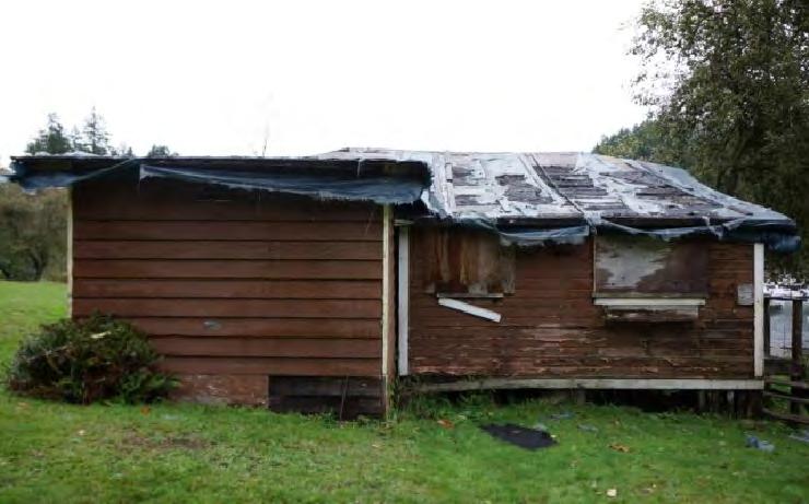
64
65 If- \ II "- _J I- D BEDROOM I ====== - L_ = F == \ " VERANDAH LIVING ROOM I- COTTAGE #9 611 SCALE: 3/1 = 1' N ffi

66

67

68
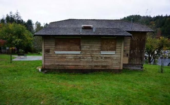
69
70

71

72

73

74
75 -' L I / [ BATHROOM g (Q') 0 c D KITCHEN /" II :: ) f''\,./ I BEDROOM r" II II. LIVING ROOM BEDROOM COTTAGE #12 N SCALE: 3/16"= 1' ffi

76
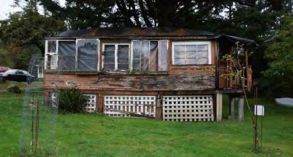
77

78

79
80 I Ir \ II "-._J w.._" \ D J = = f----j c.l r' II \ BEDROOM. U Cg o u_" \ = = J F = = \ VERANDAH n_ - LIVING ROOM - := J COTTAGE # SCALE: 3/1 = 1' N ffi

81

82

83

84
85 EXTENSION STUDIO r"" II \ \ BEDROOM,1-1-1 I I I I I [ ) l: = 1 - BATHROOM g / [Q') 0 L D KITCHEN /1 I II STOOP AND STEPS NOT CONFIRMED : L _L _L _L _L J (OBSCURED) I LIVING ROOM == F \ VERANDAH COTTAGE #17 N SCALE: 3/16"= 1' ffi

86
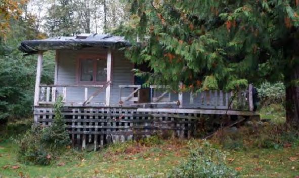
87
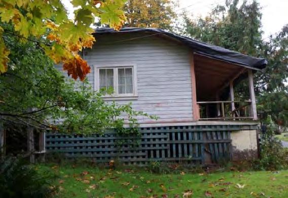
88
![WEST ELEVATION OBSCURED BY VEGETATIO DD DD 1------------------------------- [83 [OEJ] = ---- I II](/docs-images/85/92069115/images/89-1.jpg "I II I I I I I WEST ELEVATION NOT CONFIRMED (OBSCURED BY VEGETATION) COTTAGE #17 SCALE: 3/16\"= 1'")
89 WEST ELEVATION OBSCURED BY VEGETATIO DD DD [83 [OEJ] = ---- I II I II I I I I I WEST ELEVATION NOT CONFIRMED (OBSCURED BY VEGETATION) COTTAGE #17 SCALE: 3/16"= 1'
90 B Structural Assessment


91 Cottage 8. Usage: Vacant This cottage was generally in poor condition. The roof was covered in tattered plastic tarps and was leaking into the cottage at the time of inspection. The interior of the cottage was damp. The cottage is supported by vertical sections of logs supported on precast concrete footings. Extensive rot was observed in the outer support logs which have been exposed to the rain. The floor structure consisted of tongue and groove flooring supported on 2 x 6 joists spaced at 24 inches supported on 6"x6" beams which were spaced approximately 9 feet apart and spanned approximately 8'. This floor structure is typical throughout the Davies Orchard Cottages. The wood siding was a lapped heritage style. The paint on the siding was peeling at most locations. The siding on the rear addition was bevelled style. Most of this lower siding was rotten. Contact with landscaping and vegetation has caused rotting. Some siding has been replaced in the past. The roof consisted of a low to moderate slope and had approximately 1 foot overhang at the eaves. The older rolled roofing has completely failed with many missing sections. A woven plastic tarp has been installed over the old roofing, however it has disintegrated exposing the plywood sheathing below. It appears that the front porch was enclosed in the past to create more finished interior space. The interior of the cottage was damp as a result of roof leakage. Most wall and ceiling surfaces have been removed exposing fibreglass batt insulation on the ceiling and exterior walls at most locations. The windows have been boarded up with plywood on the exterior. Most of the visible glass was broken. The plywood flooring in the northwest room was rotten at most locations. 1


92 This room was unsafe to walk in. Black staining and growth on the walls is likely mold. Testing and proper remediation work will be required to remove the mold. The electrical system consisted of a 240 V service protected by a 70 amp breaker. The electrical power to this cottage was turned off. The bathroom consisted of a wall-mounted porcelain sink and an old-style toilet. The plumbing for the bathroom consisted of copper and galvanized metal water supply plumbing. The water to this unit was shut off. The cast-iron vent stack for the waste plumbing was broken off near the ceiling of the bathroom. The ceiling in the main living room was sagging at all locations. A section of the ceiling at the location between the living room and the old porch has completely collapsed. The end of the old support beam was resting on the floor. The ceiling structure consisted of 2 x 4 Joists at 42 inch spacing spanning approximately 18 feet. There was significant sagging observed at the ceiling joists as a result of the long span and wide spacing. This ceiling structure was typical in the Davies Orchard Cottages. Upgrading of the ceiling structures is recommended. Attic access was located in the northwest bedroom. The attic was wet as a result of roof leakage. The roof structure consisted of plywood sheathing over 1x4 strapping on 2x4 rafters at 24 inch spacing. The insulation on the ceiling consisted of 8 to 10 inches of fibreglass batt insulation which was mostly saturated with water. There were some small roof vents in the attic. Daylight was observed through the roof at many locations. 2


93 Cottage 9 Usage: Vacant, Reasonable Condition Support for the cottage has been upgraded in the past with an 8 inch wide concrete perimeter foundation along the north, west and south sides. Wood support posts for the interior were supported on individual cast in place concrete footings measuring 34" x 34". The floor structure consisted of tongue and groove flooring supported on 2 x 6 joist spaced at approximately 24 inches. The span of the joists was approximately 9 feet and they were supported on 6" x 6" beams spanning approximately 8 feet between 6" x 6" wooden posts. The base of the perimeter walls was supported on the concrete foundation wall with 1/2" anchor bolts spaced at approximately 4 feet which secured the bottom plate. The overlapped wood siding was in reasonable condition for its age and no rot was observed. The paint on the siding has peeled at most locations. The front porch was in poor condition and unsafe to walk on. Many of the wood decking members were rotten and missing resulting in large openings in the surface. The guard rail consisted of a horizontal 2 x 4 approximately 36 inches above the floor surface. There was visible rot in the lower part of the support structure which was supported on damp concrete or soil. The roofing consisted of cedar shingles with an approximately 4 to 5 inch exposure. Splitting was observed in most shingles. Rot was also observed. The roof had no gutters on the eaves. A missing section of facia board was observed on the north side of the roof. The interior of the cottage was generally dry. There was however leakage observed near the north west corner where a chimney was 3


94 removed. Other visible openings in the cedar shingle roofing have been leaking. The floor which mostly consisted of fir flooring was in reasonable condition. There was however a rotted section where the roof has been leaking onto the floor below the old chimney opening. The ceiling has been removed and the underside of the roof was exposed. The roof rafters were 2x4 spaced at approximately 24 inches. The visible rafters were in adequate condition. The ceiling joists were 2x4 members spaced at approximately 32 inches. They were spanning approximately 18 ft. The windows have been boarded up on the exterior. Two of the windows were visible from the interior and some of the glass panes were intact. Some pains were however broken or missing. The east window frame on the south wall was noticeably distorted. There was a slight slope in the floor and upper wall at this location. It does however appear that this window was in poorly installed and not part of the original construction. There was an older style breaker panel for the electrical. The electrical service for the cottage was turned off elsewhere. Much of the exposed wiring was knob and tube. There was some newer grounded wiring however it was poorly installed with most of the wiring not attached to the wood framing. The bathroom fixtures were removed. The visible water piping was mostly galvanized steel. Waste plumbing was cast-iron. Typical walls consisted of 2 x 4 studs at spacing from 16 inch, 24 inch to 32 inch. 4


95 Cottage 10 Usage: Museum This cottage was generally in good condition as a result of past renovation work. There was however staining observed on the ceiling and wood panelling around the brick chimney. Testing with a moisture meter found elevated readings on the underside of the roof in the kitchen and bathroom near the chimney. Inspection at roof level found tar patching at the flashings and no chimney cap. The porch railing was 24 inches high and consisted of 2 x 4 top and bottom rails with vertical 1x4 spindles with 4 inch spaces between. One of the porch roof support posts was rotted at its base. Another post has obviously been repaired as evidenced by an approximate 1 foot section of 4 x 4 added at the base of the post. The electrical system consisted of a modern breaker panel with a 40 amp main breaker. This panel was located in the kitchen. The water service to this cabin was not turned on. The plumbing fixtures were therefore not tested. The attic space was inspected from the access hatch in the Southwest bedroom. The roof structure was similar to the other colleges except vertical supports were added from the ridge beam to the mid span of the ceiling joists below. There was black roofing paper observed below the cedar shingles on the roofing. Fibreglass batt insulation approximately 4 inches thick was installed over a polyethylene vapour barrier on the ceiling. 5


96 Cottage 11 Usage: Rental, Potter's studio The exterior of the cottage was generally in poor condition. The roofing consisted of asphalt shingles which were severely eroded and missing in many locations. Patching repairs were observed, however leakage is suspected. The rear plumbing vent was open to the elements and leakage at this location is suspected. This cottage has had many additions built onto it. These additions were in poor condition. Extensive rot was observed and the footings and support posts were poorly aligned. The crawlspace was partly used for storage and access was difficult. Fibreglass batt insulation for the floor has fallen down at many locations. Vegetation has also grown into the crawlspace in the east area. The support below the west side of the rear addition has rotted in the past. Temporary plastic and wooden shims were observed below the support members. There was a noticeable sag in the roof of the rear addition. The interior of the cottage was being used as a potter's studio. Equipment and supplies took up much of the space and limited access and visibility. Sagging was observed on the ceiling of the main room. Leakage was observed at the location of the old wood stove. A large bucket containing water was observed below the opening in the ceiling. Floor slopes were observed and detected. Rot was observed at the base of the wall at the southeast addition. Water leakage was also observed in the northwest bedroom The bathroom sink and toilet did operate however the water from the sink faucet was rusty which is typical of galvanized metal piping. The floor in the bathroom was sagging and soft as a result of wood 6


97 rot. There was an old electric hot water tank in the bathroom. There was a 100 amp breaker panel installed near the south east access door. The wiring leading out of the panel was installed in BX sheathing. The window glazing was found to be intact. There were 2 inch diameter wooden poles installed where the door opening was for the northwest bedroom. The purpose of the poles was not determined. Access was not gained to the attic space because shelving was installed below the access hatch. 7


98 Cottage 12. Usage: Vacant This cottage was in mixed condition. The roof has been completely covered with plastic presumably to cover an older roofing application and prevent water leaks into the interior. The plastic material was in reasonable condition and the interior of the cottage was dry. The paint was peeling on the lapped siding. The East porch has been enclosed and its siding and windows were rotted. There was also visible rot at the support posts below the porch. There was a small unenclosed section of porch at the northeast corner which was in poor condition. The roof supports and the floor structure were rotted. The soil at the base of the west addition was against the base of the structure. Some visible rot was observed. Extensive rot should be expected in the covered structure. The crawlspace consisted of a dirt floor which was void of any storage. The support structure for the cottage consisted of a mix of 6 x 6 posts and vertical logs on precast concrete footings. Most of the older log supports were poorly aligned. The connections between the post supports and the support beams were poor. Rot was observed at the outer support posts. The support structure below the east porch was in poor condition. The interior of the cottage was generally dry however sloping floors were detected throughout. The ceiling in the enclosed porch had corrugated plastic under the applied roofing. The bathroom had a sink, toilet and bathtub installed. The plumbing was not 8


99 connected. The electrical panel consisted of a modern 100-amp breaker panel with several breakers which were labeled. Some newer wiring and receptacles were observed. The older knob and tube wiring is suspected to remain in the walls and ceiling. There was an older electric hot water tank located in one of the bedroom closets. The serial number indicated a 1994 production date and the capacity was 130 liters. The connected plumbing near the hot water tank was polybutylene piping. The attic space was inspected from the access hatch. The visible roof structure was plywood installed on the horizontal 1x4 strapping which was supported on 2 x 4 rafters at 24 inch centers. The ceiling structure consisted of 2 x 4 joists at approximately 36 in spacing. Insulation was approximately 4 inch thick fibreglass bats with a craft paper on the top side. Visible wiring in the attic was mostly knob and tube. There were rodent droppings observed throughout most of the attic space. There was no visible ventilation for the attic. 9


100 Cottage 14. Usage: Storage The roof consisted of 18 inch long cedar shingles with exposure of 3 1/2 to 4 1/2 inches. There was extensive splitting observed on the shingles and some rot. Evergreen needles and leaves covered much of the east section. There were no gutters or downpipes installed on the roof. The siding was lapped wood siding and the paint was peeling at most locations. Some lower sections of siding were missing resulting in the wall cavity and insulation being exposed to the elements. Plywood has been installed at some locations presumably to replace the older siding particularly at the base of the north wall. The rear addition on the West side was clad with plywood. There was an approximate 12 inch hole near the base of the siding on the west addition. The cottage was supported on an 8 inch wide concrete perimeter foundation with interior cast in place concrete pad supports. There was no visible connection between the wood support posts and the concrete pads. There was also no visible connection between the wood posts and the support beams for the floor. The front porch floor consisted of 3/4" inch plywood over the old tongue and groove decking. The plywood was presumably installed to cover the rotted decking which was likely unsafe. The guard rail consisted of a single horizontal 2 x 4 which was supported by the roof support posts. The deck porch stairs were wooden with five risers and four treads. There was rot in the stairs and there was no railing. The access for the crawlspace was located below the north side of the porch. The crawlspace was inspected from this area. The crawlspace was dry and consisted of a 10


101 dirt floor with no vapour barrier. There was garbage and debris on the floor. There was a plastic vapour barrier installed on the underside of the cottage floor with no insulation in some areas. Other areas found insulation hanging from the floor structure which was virtually ineffective. The interior of the cottage was used for storage. Access and visibility inside the cottage was as a result difficult. There was no visible leakage from the roof however leakage may exist in some areas that were not accessible Water damage was observed on the ceiling from past roof leakage. Visible mould was observed on some of the wall and ceiling surfaces. The wiring in the cottage appeared to be the original and was not connected. The attic space was generally dry. There was however an opening observed at the ridge near the north end. There was no roofing paper installed below the shingles. Shingles were installed directly on 1x4 horizontal strapping supported on 2 x 4 joist spaced at 24 inch. There was fibreglass insulation installed on some areas of the ceiling. There was visible knob and tube wiring in the attic. The interior of the rear West addition was poorly constructed. There was no insulation installed and there were visible gaps at the top, middle and lower portions of the walls. There was rot observed in the plywood flooring. This addition was in very poor condition. There was an old electrical junction box observed hanging from the connected wires at the northwest corner of the main room. The windows had been boarded up from the exterior. Some broken panes of glass were observed. 11
 side was growing onto the roof.")


102 Cottage 17. Usage: Furnished, but not occupied This cottage was generally in poor condition. The roof was covered with a woven plastic material. The plastic was in poor condition with holes at many locations and leakage should be expected. Vegetation at the rear (west) side was growing onto the roof. The lapped siding was for the most part in reasonable condition for its age. There was however some rot observed in the lower boards which have been in contact with soil and vegetation. The windows were not covered with plywood. The glazing was still intact and the window frames were in reasonable condition. The overhead Hydro service came from a pole to the South of the cottage and dropped to a meter on the south wall. There was a small uncovered porch at the southwest corner. This porch and the stairs were rotted and in poor condition. There was a pit in the ground on the west side of the cottage which was covered with some rotted wood. The purpose of this pit was not confirmed but may be from an old septic system. The crawlspace consisted of a dirt floor which was covered with fibreglass bat insulation and other construction debris. The support for the cottage was non-dimensional wood members or logs supported on small precast concrete footings. There was no visible attachment between these vertical post members and the beams above or to the footings below. There was also no diagonal bracing for the structure. There was a strong rodent odour detected inside the cottage. Fallen insulation on the floor and rat droppings were observed all over the interior. 12


103 Water stains were observed on the plywood ceiling in the main room. Leakage was also observed around the poorly installed skylights. The walls consisted of plywood and were in reasonable condition. There was a 100 amp modern breaker panel located on the south wall of the main room. Wiring from the panel was installed in protective BX sheathing. Staining and rot was observed at the west wall of the kitchen addition. There was a copper propane pipe leading from the west wall to the stove. Loose cross-link polyethylene piping was found lying on the floor of the kitchen. The bathroom had three plumbing fixtures installed. The ceiling in the main room has been modified in the past to its present vaulted layout. It appears that the original 2 x 4 rafters have been used as supports and no visible upgrading of the structure was visible. 13


104 Cottage 18. Usage: Holiday Rental This cottage was generally in good condition. It was being used as a vacation rental. The roof consisted of 18 inch cedar shingles. There was noticeable rot in the shingles and the rear side of the roof on the east side was completely covered in moss. There were aluminum gutters and downpipes installed on the front and rear eaves. The gutters were stained and there were some dents in the gutters and downpipes. There was a stainless steel a chimney on the east side which is used for the wood-burning stove. The lapped wood siding was generally in good condition. There was some peeling paint observed on the north side of the cottage. The windows were in satisfactory condition. The lower skirting around the crawlspace was in reasonable condition. There was some rot observed at the northwest corner which has resulted from water discharge at the adjacent roof downpipe. The front porch was in satisfactory condition. There was some rot observed at the base of the north roof support post. The height of the guard rail was 36 inches and the space between the 1x4 verrtical pickets was 3 inches. The interior walls and ceilings were finished with plywood paneling. The floors consisted of painted fir flooring in the main living room / bedrooms with linoleum in the bathroom and kitchen. The bathroom has been updated and the fixtures functioned properly. There was an exhaust fan which was controlled by a timer switch. There was a GFCI electrical outlet near the sink. Heating consisted of electric baseboards in each room which were controlled by Nortron thermostats. All heaters functioned properly when tested. The electrical system consisted of a modern breaker panel with a 100 amp main disconnect. The various circuits on the panel were labeled. The roof structure was much the same as the other 14


105 cabins however diagonal supports have been installed at most rafters north of the access hatch. There were no added supports to the south. The insulation consisted of approximately 10 to 12 inches of fibreglass batt insulation. There was no vapour barrier found beneath the insulation. Venting for the attic consisted of gable vents at the north and south sides. There were two separate sections to the crawlspace. There was an upgraded area with full headroom and a concrete slab floor located below the southeast area of the cottage. There was insulation installed on the ceiling with a vapour barrier below. There was an electric hot water tank which was wrapped with foil insulation located at the rear of this space. The age of the tank and capacity were not determined. The other crawlspace areas had sloped dirt floor with the plastic vapour barrier on top. These areas were dry. The ceiling had fibreglass insulation between the joists and no vapour barrier installed. The water service was located near the access door at the southeast corner. The service pipe was polyethylene connected to copper piping at the main shut off valve. There was a pressure reducing valve installed above the main shut off. The exterior walls in the upgraded part of the crawlspace appear to have been recently replaced. The bottom plates were bolted to the foundation with half inch anchor bolts. 15
 side of the roof had moss growing on it with accumulations of needles and small branches.")


106 Cottage 19. Usage: Vacation Rental This cottage was in reasonable condition and was being used as a vacation rental. The roof consisted of 18 inch cedar shingles. There was noticeable splitting and some rot. The back (west) side of the roof had moss growing on it with accumulations of needles and small branches. There were no gutters installed on the roof eaves. The brick chimney was in good condition however there was missing flashing observed on the north and south sides. The roof had approximately 12 inch eaves. The overlapped wood siding was in good condition for its age and the paint was in satisfactory condition. The front porch appeared to be in satisfactory condition. The guard rail was however low. It only measures 28 inches in height, presenting a safety hazard. The crawlspace had a dirt floor with no vapour barrier. The floor surface was partly covered with construction debris such as polyethylene, insulation and lumber. The underside of the floor structure had plywood fastened to it. The floor structural members were therefore not visible for inspection. The outer support structure consisted of 6 x 6 posts supported on concrete footings with metal saddle connectors. There was a plywood and 2 x 4 wood skirt around the perimeter which was elevated slightly above ground level to protect it from moisture. The interior support posts consisted of sections of non-dimensional logs supported on concrete footings. There were no visible connecters between the footing and the logs and at the top beam connection. There was no diagonal bracing observed in the crawlspace. 16


107 Cottage 20. Usage: Bowen Heritage This cottage is used for the Bowen Heritage group. Overall it was in reasonably good condition. The roof consisted of 18 inch cedar shingles. Some rot and splitting was observed on the shingles. Metal shims have been installed under many of the shingles in an attempt to prevent leakage at the splits. The roof was almost completely covered with evergreen needles and branches. There were no gutters installed on the eaves. The overhang at the eaves was approximately 1 foot. The wood siding and paint was in reasonably good condition. The front porch was in satisfactory condition; however the guardrail was of insufficient height. It measured 27 inches high. The interior was in reasonably good condition. The floors were fir. The walls were clad with plywood veneer. The plumbing fixtures were all tested and found to be functional. Hot water was provided by an electric tank with a production date of 2005 and capacity of 30 Imperial gallons. The water supply plumbing was Pex and the waster plumbing was ABS plastic. The attic access hatch was located in the Northeast bedroom. The roof structure consisted of 2 x 4 rafters at 24 inch centres with 1x4 horizontal strapping and black roofing paper under the installed shingles. Additional diagonal supports have been installed below the ridge beam in the south area of the attic. There was some sort of nest made out of hay observed in the south area of the attic. No ventilation was observed for the attic. Insulation consisted of fibreglass batts with an approximate depth of 12 inches. There was no vapour barrier observed below the insulation. Rodent droppings were observed in the attic. The breaker panel was located in the kitchen. The 17

108 capacity of the panel was rated at 100-amps. The various circuits on the panel were labeled. The lights that were tested functioned properly. There was some distortion in the tongue and groove decking at the front porch. An inspection of the underlying structure was not carried out. Access was not gained to the crawlspace below the cottage. It does however appear that this cottage has a perimeter concrete foundation. 18
109 Recommended Work on Cottages The following is a summary of the recommended work for the various cottages. In general, most cottages require work to upgrade the structural support in the crawl space and the ceiling structure in attic areas. The design and extent of this work will have to be determined by local authorities and a structural engineer. These cottages were built in the 1920s prior to the requirement for Building Permits and Code Compliance. In order to bring the structures up to current Building Code Requirements, extensive work will be required and this work will be costly. Mold was observed in some of the cottages which have been leaking rainwater and were vacant. Remediation work will be required to remove any mold growth that is found. The work outlined in the following list should meet the requirements of the various Building Codes and Worksafe BC. Some upgrade requirements which are consistent with most of the cottages are as follows: The sub-structure can be upgraded by installing larger cast in place concrete footings. Wood support posts should be installed and supported on metal stirrup brackets which are embedded in the concrete footing and mechanically fastened to the post. The tops of the posts should be secured to the wood beams with metal T-brackets. Diagonal bracing should be installed for lateral support. The ceiling structures in the cottages are under-designed and there is no present ability to remove any walls. Upgrading of the ceiling structure will require a detailed design by a structural engineer. Porch guardrails should be minimum 36" high with spacing between vertical spindles of no more than 4". Improved ventilation in attics can be achieved by installing a continuous ridge vent. This type of vent is less noticeable than other conventional vents and helps keeps the heritage look. Cottage 8 (Poor condition, damp and mouldy): Install new concrete footings, support posts with brackets, cross bracing Replace any rotten siding and re-paint all exterior surfaces Replace the roofing, install gutters and downpipes Strip out and replace any insulation, wall finishes, wiring 19
110 Replace the collapsed roof support beam between the old porch and the main area of the cottage, upgrade the ceiling structure Re-wire the cottage, install new insulation, vapour barrier and wall / ceiling finishes Re-finish the window frames and replace any broken or missing glazing Re-finish or replace the flooring Remove or re-build the addition at the northwest corner Cottage 9 (Vacant, damp, reasonable condition): Foundation has been redone, install brackets at support posts Exterior painting required Re-build front porch, railing and stairs Replace roofing, install gutters and downpipes Upgrade the ceiling structure Strip out and replace any insulation, wall finishes, wiring, Re-finish the window frames and replace any broken or missing glazing. Reinstall distorted frame at east end of south wall. Cottage 10 (Museum, good condition): Support posts and footings are adequate. Install top and bottom brackets on the posts. Present leak at chimney. Replacement of roofing and chimney work is required. Replace porch guardrail (too low and some rot) Upgrade support for ceiling in attic. Cottage 11 (Rented to potter, poor condition): Replace the roofing, gutters and downpipes 20
111 Replace any rotten siding, re-paint siding and re-finish windows Remove any additions to the cottage Install new footings and post supports Upgrade the support for the ceiling structure Strip out and replace any insulation, wall finishes, wiring, Attic was inaccessible. Inspect and make necessary upgrades Cottage 12 (Used for storage, poor condition but dry): Replace the roofing, gutters and downpipes Install new footings and post supports Remove the porch at the northeast corner Replace any rotten wood siding and re-finish the windows. Re-paint the exterior. Repair or remove the west addition Re-wire the cottage, install new insulation, vapour barrier and wall / ceiling finishes Upgrade the ceiling structure Address the rodent problem in the attic. Provide improved ventilation in the attic Cottage 14 (Used for storage, dry, reasonable condition): Replace the roofing, gutters and downpipes Replace any missing or rotten siding. Remove or repair the addition at the rear of the cottage Has concrete perimeter foundation...install brackets to connect the support posts to the footings and support beams 21
112 Re-build the entire front porch and stairs Remove any mould found on the interior Replace the electrical system Remove or re-build the rear addition Re-finish the windows and replace any broken or missing glazing Cottage 17 (Poor condition, rat infestation) Replace the roofing, gutters and downpipes Replace any rotten siding Replace front porch guardrail Remove or re-build the southwest porch Install new concrete footings, support posts with brackets, cross bracing Exterminate any rats from the cottage and cleanup any feces and urine. Remove or replace the plumbing and propane piping Upgrade the ceiling structure which has been vaulted in the past Cottage 18 (Rental Cottage, good condition): Some maintenance required. Remove moss from roof Paint wood siding Repair porch stairs and railing Cottage 19 (Rental Cottage, good condition) Remove moss from roof. Near term replacement of shingles. 22
113 Install new interior concrete footings, support posts with brackets, cross bracing Replace missing chimney flashings. Replace porch guardrail. Cottage 20 (Bowen Heritage, good condition): Metal shims found under shingles, near term roofing replacement Attach support cable to mast for hydro service Upgrade the porch guardrail to 36 inch height. 23
114 C Cottage Restoration Costs
115 [ page intentionally blank ]
116 PROJECTED ESTIMATES TO COTTAGES AT ORCHARD All targeted estimates are provided based on report and pictures provided by an inspection firm. I had a discussion with the inspector and got input and recommendations from him. The targeted estimates are also based on better building practices, following BC Building Codes. The project would most likely need involvement on a structural engineer, and municipal permit and inspector. For full rebuild, possible surveys may also be needed. None of these costs are included. Each cottage and project has a large variety of special issues, and most likely be in the need of inspector from health and safety before my work was to be done, asbestos or lead paint removal would not be included in this, but could be provided once project was to move forward. A more detailed targeted estimate would be made prior to construction, where full material lists and budgets, with sub trades would be presented for approval. These jobs would be under contract of a cost plus 15% on materials, labour and sub trades and an agreed payment schedule. Cottages that are deemed demo or suggested rebuild would be recommended for use of salvage and materials used for other projects. Enough projects presented show me that a lot of salvage from others would be cost effective and able to get more original full finish buildings. A full detailed estimate from Bowen Island Construction Ltd. and better budget numbers would result in an agreed fee and another site visit with someone of authority to make decisions and details for pricing. All prices are GST, 15% not included All projects that are not just maintenance would recommend tohave at least a $25, plus contingency fund. All cottage numbers and details were taken by info and notes from Building Inspector hired by another party. All work that is deemed approved by other parties is and will not be covered or insured by Bowen Island Construction Ltd. All projects could vary in prices, based on findings by contractor, or demo or design ideas. Also engineer designs could be greatly change all prices. All prices are estimates and don`t reflect on set cost and could rise or fall based on many factors. Targeted Estimates Provided on Cottages Based On Material/Pictures given

117 PROJECTED ESTIMATES TO COTTAGES AT ORCHARD Cottage 8 $187, Rebuild based on basic design and build. Demo separate cost- est-$15, Machine done Cottage 9 $135, Cottage 10 $60, Cottage 11 $187, Rebuild basic design and build Demo separate machine done $15, Cottage 12 Suggest rebuild and use for salvage parts such as windows for other Structures. Cost would mirror new cost builds. Cottage 14 $155, Cottage 17 $160, Cottage 18 $35, Cottage 19 $48, Cottage 20 $55, Sea Side Cottage 2 Rebuild- $187, Targeted Estimates Provided on Cottages Based On Material/Pictures given
118 d Davies Orchard Chronology
119 BRIEF CHRONOLOGY OF DAVIES ORCHARD The following are historical events, movements, occurrences and changes that have made the Davies Orchard site what it is today. The Squamish name for Bowen Island is Xwlíl xhwm, meaning fast drumming ground In the Squamish creation story, Xwlíl xhwm is often referred to as the place where the deer were created. The island is used primarily as a stopping ground on journeys up and down the coast by the Squamish and other First Nationsl Explorer José Maria Narváez charts the island, naming it Isla de Apodaca Bowen Island is renamed in honour of Rear Admiral James Bowen, master of HMS Queen Charlotte, who named the island s chief geographical features: Snug Cove, Deep Bay, Mount Gardner, Cape Roger Curtis, Collingwood Channel The first land pre-emption on Bowen is made by William Eaton William Davies, originally from Ontario, and then a tailor in Vancouver, pre-empts 33 acres of land at the head of Snug Cove Royal City Planing Mills purchases 220 acres near Snug Cove for timber harvesting William Davies reports the following varieties grown in his orchard: Wealthy, Red Astrachan, Gloria Mundi, Rhode Island, Greening and Red and Yellow Bellflower apples; Yellow Egg, Washington Peach;, Damson and Yellow Gage plums; Royal Anne, Early Black and Yellow Spanish cherries; and Alexander peaches Joseph Mannion purchases District Lot 492 on Bowen Island Captain John Cates purchases the Mannion estate and creates a resort for holiday excursionists. Bowen becomes an important destination for tourists. William Davies rents tents to visitors wanting to camp and later sets up wooden platform tent sites among the fruit trees With partners, Captain Cates forms the Terminal Steamship Company. Their Steamship Britannia becomes the most modern excursion boat sailing out of Vancouver. 1920s The Union Steamship Company buys the original William Davies landholding along with Captain Cates Terminal Steamship Company property. Union Steamships operate freight and passenger ships that serve remote communities up and down the coast of B.C. The company begins its expansion of Snug Cove and Deep Bay into a major destination for day tourists and summer residents. Six large picnic grounds, a hotel and other amenities are constructed. The Company brought in the Lady steamers to carry passengers, including the Lady Alexandra holiday cottages are built in the Orchard Tourism peaks on Bowen Island, declining after World War II The first car ferry, run by the Black Ball Ferry Corporation begins The Greater Vancouver Regional District purchases the former Union Steamships land and creates Crippen Regional Park The Davies Orchard area becomes part of the park The Bowen Island Heritage Preservation Association is formed to save the Orchard and remaining cottages.
120 e References
121 Biophysical Review: Snug Cove Area of Crippen Regional Park, Catherine Berris Associates Inc., (undated, circa 1998). Bowen Island Visitors Survey: In Search of the Emotional Heart of the Visitor Experience. Economic Development Sub- Committee, Bowen Island Municipality Official Community Plan, Consilidated Version, December Bowen Island Heritage Inventory (author unknown) retrieved November 2016 from: document/95889 Ferry Marshalling Options for Snug Cove, Phase 1 Report. Transportation Working Group, Bowen Island Municipality, Howard, Irene. Bowen Island Bowen Island, B.C.: Bowen Island Historians, Life in an Orchard : A Guide to Programs in the Davies Heritage Orchard. D.G. Whitehead and G. Preston, (undated). Pacific Great Blue Heron Nesting Activities ( ) Bowen Island, B.C. B. Gowans RavenCraig Biological Consulting, Seaside Cottage No 2. Conservation Plan. McGinn Engineering & Preservation Ltd, Crippen Regional Park, Bowen Island Feasibility Assessment, Metro Vancouver Park Staff, Orchard Area Redevelopment Guidelines (from GVRD Park Committee Reports ), Bowen Heritage, Snug Cove, Bowen Island, BC Biophysical Attributes and Environmentally Sensitive Areas. Dunster & Associates Environmental Consultants Ltd., 2001 Snug Cove Master Plan: Eco Village in the Park A Blueprint for a Sustainable Island, Hotson Bakker Boniface Haden, 2008 Snug Cove Picnic Area Redevelopment, DM Group Landscape Architects and Park Planners, Island Plan 2016, Bowen Island Municipality, Village Design and Transportation Concepts, JWT Architecture and Planning, Visits, Visitor Services & Volunteering by the Numbers 2015, Metro Vancouver Regional Parks, 2016.

122
CRIPPEN REGIONAL PARK
 CRIPPEN REGIONAL PARK DAVIES ORCHARD CONCEPT OPTIONS Jeffrey Fitzpatrick Sylvia Pendl DIVISION MANAGER, REGIONAL PARKS, WEST AREA PARK PLANNER, REGIONAL PARKS, WEST AREA Bowen Island Municipality, September
10.0 Open Space and Public Realm
 10.0 Open Space and Public Realm 10.0 Open Space and Public Realm The Public Open Space System is comprised of: outdoor spaces available for public use that are either publicly owned (e.g., parks and
DEFINED VILLAGE CENTRES & NEIGHBOURHOODS
 DEFINED VILLAGE CENTRES & NEIGHBOURHOODS residents in Nanoose Bay support focusing attractive, planned future development in Red Gap Centre and the Area s neighbourhood centres. In addition, the development
April 11, 2016 Park Board Chair and Commissioners General Manager Vancouver Board of Parks and Recreation New Brighton Salt Marsh - Preferred Concept
 TO: FROM: SUBJECT: April 11, 2016 Park Board Chair and Commissioners General Manager Vancouver Board of Parks and Recreation New Brighton Salt Marsh - Preferred Concept RECOMMENDATION A. THAT the Vancouver
Mark-up of the effect of the proposed Bronte Village Growth Area OPA No.18 on the text of section 24, Bronte Village, of the Livable Oakville Plan
 Mark-up of the effect of the proposed Bronte Village Growth Area OPA No.18 on the text of section 24, Bronte Village, of the Livable Oakville Plan Notes: This document is provided for information purposes
Marshview Park. Concept Briefing and Feedback Session. Aquarium/Owls Creek Plan Steering Committee March 20, 2012
 Marshview Park Concept Briefing and Feedback Session Aquarium/Owls Creek Plan Steering Committee March 20, 2012 1 Outline of Today s Discussion Introductions Context for Marshview Park Site analysis -
ACADEMY AREA CONCEPT PLAN
 ACADEMY AREA Strip ling C hape l Roa d CONCEPT PLAN 7 S2 U Stripling 52 ROADWAYS AND PARKING: ADVENTURE PLAYGROUND AND SPRAYGROUND: Current roadways follow existing drives. It is recommended that the Folds
2.1 Location and Size
 2.0 Context 7 2.1 Location and Size The Saanich Penninsula The study area is centrally located within the Town boundaries on the east side of Highway 17, which runs through Sidney in a north-south direction.
SECTION ONE: INTRODUCTION. introduction
 introduction 1 INTRODUCTION Since it was first established in 1843 as a trading post for the Hudson s Bay Company, Victoria has evolved into a Provincial capital city that is recognized across Canada and
URBAN DESIGN BRIEF Gordon Street City of Guelph. Prepared on behalf of Ontario Inc. March 25, Project No. 1507
 URBAN DESIGN BRIEF 1131 Gordon Street City of Guelph Prepared on behalf of 1876698 Ontario Inc. March 25, 2016 Project No. 1507 423 Woolwich Street, Suite 201, Guelph, Ontario, N1H 3X3 Phone (519) 836-7526
Stormwater Standards. Clackamas County Service District No. 1. Planting Guide for Buffers
 Stormwater Standards Clackamas County Service District No. 1 APPENDIX B Planting Guide for Buffers Table of Contents Appendix B - Planting Guide for Buffers... Page B.1 General... 1 B.1.1 Introduction...
Draft Master Plan for Franklin Park
 Draft Master Plan for Franklin Park Metro Parks Tacoma with SiteWorkshop November 2009 I. overview & background Process & History Master Plan Process The Master Plan is based on a community involvement
Urban Design Brief Proposed Residential Development 5219 Upper Middle Road City of Burlington
 Urban Design Brief Proposed Residential Development 5219 Upper Middle Road City of Burlington Prepared by Weston Consulting Prepared for BLOOMFIELD DEVELOPMENT INC. Date: March 2017 Table of Contents 1.
Official Community Plan Bylaw No. 4360, 2004, Amendment Bylaw No. 4897, 2016 (Sewell s Landing)
") District of West Vancouver Official Community Plan Bylaw No. 4360, 2004, Amendment Bylaw No. 4897, 2016 (Sewell s Landing) Effective Date: 1089612v1 District of West Vancouver Official Community Plan Bylaw
District of West Vancouver Official Community Plan Bylaw No. 4360, 2004, Amendment Bylaw No. 4897, 2016 (Sewell s Landing) Effective Date: 1089612v1 District of West Vancouver Official Community Plan Bylaw
Wide asphalt driveway abutting school property. garage built with incompatible materials, too close to park. incompatible fencing materials
 Wide asphalt driveway abutting school property incompatible fencing materials garage built with incompatible materials, too close to park Lack of plantings as a buffer between private property and open
Master Site Development Plan (MSDP) Rocky View County Campus at Balzac East
 Rocky View County Campus at Balzac East") Master Site Development Plan (MSDP) Rocky View County Campus at Balzac East Balzac East, Alberta July 2009 CONTENTS 1.0 purpose 1 2.0 guiding principles 2 3.0 site description 3 4.0 site analysis and county
Master Site Development Plan (MSDP) Rocky View County Campus at Balzac East Balzac East, Alberta July 2009 CONTENTS 1.0 purpose 1 2.0 guiding principles 2 3.0 site description 3 4.0 site analysis and county
APPENDIX C. Architectural and Environmental Design Standards. Environmentally sensitive areas should be protected.
 APPENDIX C Architectural and Environmental Design Standards Environmentally Sensitive Areas Goal A. Environmentally sensitive areas should be protected. Development, such as roads, houses, and other structures,
SCC PRD (2016) COUNTY PARK MASTER PLAN
 COUNTY PARK MASTER PLAN") SCC PRD (2016) COUNTY PARK MASTER PLAN MASTER PLAN UPDATE PARKS AND RECREATION COMMISSION NOVEMBER 7, 2018 PURPOSE OF THE MASTER PLAN The Sanborn County Park Master Plan will provide the Department with
SCC PRD (2016) COUNTY PARK MASTER PLAN MASTER PLAN UPDATE PARKS AND RECREATION COMMISSION NOVEMBER 7, 2018 PURPOSE OF THE MASTER PLAN The Sanborn County Park Master Plan will provide the Department with
4. INDUSTRIAL 53 CASTLE ROCK DESIGN
 4. INDUSTRIAL 53 CASTLE ROCK DESIGN CASTLE ROCK DESIGN 54 4. INDUSTRIAL Overview Well-designed and attractive industrial centers are the product of blending economic realities with both functional and
Southwest Fleetwood Enclave
 Southwest Fleetwood Enclave Development Concept Plan Southwest Fleetwood Enclave 1 st Land Owners Meeting April 30 th, 2012 Presentation Overview Why the Plan? ; Overview & Purpose of Study; Constraints
ELLIOTT HEADS STRUCTURE PLAN
 ELLIOTT HEADS STRUCTURE PLAN BACKGROUND This report has been prepared to provide an overview of the land that has been included in the Urban Footprint within the Wide Bay Burnett Regional Plan, September
East Bayshore Road Neighbourhood
 East Bayshore Road Neighbourhood Northridge Property Management Urban Design Brief 3195 East Bayshore Road City of Owen Sound January 2016 East Bayshore Road Neighbourhood Northridge Property Management
Daniels Park Master Plan
 Daniels Park Master Plan Prepared for: Douglas County & The City and County of Denver October, 2007 EXHIBIT A Contents Daniels Park Overview 2 Project History & Goals 2-3 Regional Context Map 4 Park Zone
City of Farmington. Downtown Plan. Amendment to the 1998 Master Plan Adopted October 11, 2004
 City of Farmington Amendment to the 1998 Master Plan Adopted October 11, 2004 Introduction Planning Background 1 Scope and Components of the Plan Amendment 2 Concept Introduction 3 Plan Concepts 3 Conceptual
PART AOTEA PRECINCT
 CONTENTS... PAGE AOTEA PRECINCT...4 14.5.1 INTRODUCTION...4 14.5.2 RESOURCE MANAGEMENT ISSUES...4 14.5.3 RESOURCE MANAGEMENT OBJECTIVES AND POLICIES... 4 14.5.4 RESOURCE MANAGEMENT STRATEGY...5 14.5.5
URBAN DESIGN BRIEF 181 Burloak Drive, Oakville
 URBAN DESIGN BRIEF 181 Burloak Drive, Oakville February 2017 Our File: 1730B 230-7050 WESTON ROAD / WOODBRIDGE / ONTARIO / L4L 8G7 / T: 905 761 5588/ F: 905 761 5589/WWW.MHBCPLAN.COM TABLE OF CONTENTS
The Planning Partnership Baird + Associates TCI Management Consultants Ltd. Plan B Natural Heritage Wills Consulting Engineers Poulos & Chung Limited
 Little Lake Master Plan The Planning Partnership Baird + Associates TCI Management Consultants Ltd. Plan B Natural Heritage Wills Consulting Engineers Poulos & Chung Limited May 26, 2009 Purpose of Study
Regional Context Statement
 Regional Context Statement REGIONAL CONTEXT STATEMENT 3. REGIONAL CONTEXT STATEMENT In 1995, the Provincial Government passed into law the Growth Strategies Act. The purpose of this provincial initiative
Complete Neighbourhood Guidelines Review Tool
 Complete Neighbourhood Guidelines Review Tool Prepared By: City of Regina Planning Department October 2014 Page 1 of 14 Community Development Review Checklist for Secondary Plans and Concept Plans The
Study Area Map. Wasatch Hollow Open Space Restoration, Use, & Management Plan. Legend. Harrison Ave East. Roosevelt East.
 Harrison Ave Roosevelt Emerson «4 «5 Rosecrest 1900 East «3 1800 East Wasatch Hollow Open Space Restoration, Use, & Management Plan Study Area Map Legend «2 «1 Potential Access Location Emigration Creek
1. Parks & Recreation Neighborhood Parks Community Parks Special Use Sites 2. Open Space 3. Trails
 Appendix A: Park Classifications The intent of parks and recreation classifications is to aid in making acquisition and design decisions for park sites, facilities and the organization of recreation space
{Best Practices. Summary of Tools, Strategies and Best Practices from 11 Michigan Case Study Communities
 Case Studies Michigan Coastal Community Working Waterfronts { Summary of Tools, Strategies and from 11 Michigan Case Study Communities Table of Contents Zoning...2 Community and Stakeholder Collaboration
New-Cast Mixed-use Development Proposal King Street West, Newcastle, Ontario
 URBAN DESIGN BRIEF New-Cast Mixed-use Development Proposal King Street West, Newcastle, Ontario TABLE OF CONTENTS: 1.0 Executive Summary 2.0 Creating Vibrant and Sustainable Urban Places: Excerpts from
South th E ast Communit ity Centre (SECC)
") South East Community Centre (SECC) 1 New Park Design & Community Centre Update Thursday, February 8, 2018 Public Open House Thank you for attending this Open House! The town and the Consulting Team will
South East Community Centre (SECC) 1 New Park Design & Community Centre Update Thursday, February 8, 2018 Public Open House Thank you for attending this Open House! The town and the Consulting Team will
Preliminary Sketch Plan for Fort Hunter Park
 Preliminary Sketch Plan for Fort Hunter Park Public Presentation November 19, 2009 Dauphin County Parks and Recreation 100 Fort Hunter Road Harrisburg, PA 17110 (717) 599-5188 www.dauphinc.org THOMAS COMITTA
Chapter 4: Jordan Road Character District
 4: Jordan Road Character District 4.1 Introduction The Jordan Road character district encompasses much of the former Jordan orchard and farmstead, which was a significant part of Sedona s history. The
Neighborhood Districts
 NEIGHBORHOOD DISTRICTS SEVEN MAIN DISTRICTS Neighborhood Districts While the Development Plan provides a broad-scale overview of the neighborhood, this section focuses on uses and relationships at the
4. Parks, Open Space and Urban Forest
 4. Parks, Open Space and Urban Forest Goals 1. Enhance parks as public gathering places for the neighbourhood 2. Refresh park facilities to attract diverse ages and activities 3. Improve waterfront access
Hockessin Community Redevelopment Plan
 Hockessin Community Redevelopment Plan 3.1 Introduction The Community Redevelopment Plan for the Village of Hockessin is the result of the people s vision for a distinct village center that serves as the
Hidden Pointe Landscape Master Plan. June, archi terra
 Hidden Pointe Landscape Master Plan June, 2006 t h e archi terra g r o u p 1 Table of Contents Background Purpose and Goals of the Master Plan Master Plan Process Existing Conditions Entrance Hidden Pointe
3.1 Existing Land Use
 3.0 Land Use This strategy has been developed taking into account the position of the Town of Sidney as the economic center of the Saanich Peninsula. It acknowledges existing land use patterns in the downtown
Philip A. Ginsburg, General Manager Toks Ajike, Acting Planning and Capital Program Director
 Date: March 7, 2018 To: Through: From: Subject: Recreation and Park Commission Capital Committee Philip A. Ginsburg, General Manager Toks Ajike, Acting Planning and Capital Program Director Dan Mauer,
Welcome! HORSESHOE BAY PARK. Welcome!
 Welcome! HORSESHOE BAY PARK Welcome! Where are we in the process? Today we would like your input on how Horseshoe Bay Park can be upgraded to serve the community s needs better. CONSULT STAKEHOLDERS TAKE
Figure 3-1: Public Realm Plan
 3 Public Realm Figure 3-1: Public Realm Plan 3.1 Public Realm Concept The public realm concept for the Little Mountain site integrates a clear and accessible movement network with public spaces for social
section five BEAUTIFICATION PLAN
 section five BEAUTIFICATION PLAN BEAUTIFICATION PLAN Section Five Beautification Plan The goal of the Beautification Plan is to improve the Route 8-Sunnyland Corridor in terms of aesthetics and to create
The Vision. Photo provided by The Minervini Group. 46 Vision, Objectives & Strategies
 Vision, Objectives & Strategies The is the public framework and guide for future development of the Grand Traverse Commons. The establishes public polices for infrastructure, the preservation of natural
Lawrencetown Beach & Rainbow Haven Beach
 Lawrencetown Beach & Rainbow Haven Beach Public Engagement Session Wednesday, September 27 th, 2017 6:00pm 8:00pm Cole Harbour Place 51 Forest Hills Pkwy, Dartmouth Agenda Welcome & Introductions Overview
BOWEN ISLAND MUNICIPALITY
 Greenways Advisory Committee Page 1of 4 December 16, 2010 BOWEN ISLAND MUNICIPALITY Minutes of the regular meeting of the Greenways Advisory Committee held on Thursday December 16, 2010 at 5:15 p.m. in
Small Area Plan. South Gateway
 Small Area Plan Adopted May 12, 2008 South Gateway Purpose. The South Gateway Small Area Plan defines the City s expectations for the future of the southern entrance to the City at Interstate 85 and Highway
Parks Master Plan Implementation: Phase I Waterfront Use and Design REPORT #: September 7, 2016 File #
 0 'O DI Lan-171-14 1 - THE CORPORATION OF THE TOWN OF COBOURG..,. STAFF REPORT TO: FROM: Mayor and Members of Council Dean A. Hustwick, Director of Recreation and Culture DATE OF MEETING: Committee of
Hedges Pond Recreation Area & Preserve
 INTRODUCTION Weston & Sampson Master Plan Presentation Hedges Pond Recreation Area & Preserve Plymouth, Massachusetts June 11, 2009 Our Priority: Completion of a Master Plan that establishes realistic
1999 Approval to replace World War I monument and relocate plaques Approval to rehabilitate the Chase Mill building and surrounding site
 Memorandum PLANNING DIVISION DEPARTMENT OF COMMUNITY AND NEIGHBORHOODS To: Historic Landmark Commission From: Katia Pace, Principal Planner Date: October 26, 2016 Re: Liberty Park Improvements The purpose
Mississauga Waterfront. Parks Strategy - Draft
 Potential configuration for river s edge seating. Boating on Credit River: A regatta Boating on Credit River: Active enjoyment 5.2 Port Credit Memorial Park West Priority Park 5.2.1 Site Opportunities
MILL POND OVERLOOK. A project of the Town of Oyster Bay. Prepared by Cameron Engineering & Associates, LLP
 MILL POND OVERLOOK A project of the Town of Oyster Bay Prepared by Cameron Engineering & Associates, LLP Funded in part through an EPF grant from the NYS Department of State Project Goals & Advisory Committee
JACKsON STREET PIER CONCEPTUAL DESIGN PACKAGE SEPTEMBER 21, 2017
 JACKsON STREET PIER CONCEPTUAL DESIGN PACKAGE SEPTEMBER 21, 2017 JACKsON STREET PIER Process outline DESIGN PROCESS OVERVIEW: Sandusky s Jackson Street Pier Conceptual Design process included input from
Preface. Erie. Scranton. Allentown. Pittsburgh. Harrisburg. Philadelphia
 The Southern Alleghenies Region The Southern Alleghenies Region spans the Laurel Highlands and Allegheny Front in the west across the Appalachians to the east. It is comprised of Blair, Bedford, Cambria,
What s unique and valuable about the Terra Nova North West Quadrant Lands?
 Attachment 1 What s unique and valuable about the Terra Nova North West Quadrant Lands? Unique Setting great access and views adjacent to popular recreational corridor adjacent to Terra Nova Natural Area
TSAWWASSEN TOWN CENTRE REDEVELOPMENT BLOCK A 004
 Current Context The context for the project includes storey multi-family residential to the northwest, a TD bank immediately north, highway oriented commercial to the east, a surface parking lot to the
Courthouse Square Planning & Urban Design Study. Courthouse Square Working Group #13 October 15, 2014
 Courthouse Square Planning & Urban Design Study Courthouse Square Working Group #13 October 15, 2014 1 Courthouse Square Process Working Group Community Courthouse Square Advisory Groups & Civic Associations
Town of Cobourg Heritage Master Plan. Statutory Public Meeting
 Town of Cobourg Heritage Master Plan Statutory Public Meeting April 25 th 2016 Presentation Overview 1. Introduction 2. Project background and schedule overview 3. Review of strategic direction content
I. VISUAL/AESTHETICS/NEIGHBORHOOD CHARACTER. b. Existing Conditions Views from Kimball Avenue
 I. VISUAL/AESTHETICS/NEIGHBORHOOD CHARACTER 1. Existing Conditions a. View Of The Site From Area Roads Figures IV.I-2, I-3 and I-4 depict existing views from the Cross County Parkway, Central Park Avenue,
T O W N O F H I G H R I V E R
 T O W N O F H I G H R I V E R o p e n s p a c e p l a n The Town of High River, 30 minutes South of Calgary, still retains much of its distinctive small town character and provides residents with a high
RZC Public View Corridors and Gateways
 RZC 21.42 Public View Corridors and Gateways 21.42.010 Purpose 21.42.020 Scope and Authority 21.42.030 Administration 21.42.040 Gateways Design 21.42.050 Unidentified Public Views 21.42.060 Identification
H7 Open Space zones. (a) provide for the needs of the wider community as well as the needs of the community in which they are located;
 provide for the needs of the wider community as well as the needs of the community in which they are located;") H7. Open Space zones H7.1. Background The majority of land zoned as open space is vested in the Council or is owned by the Crown. However some areas zoned open space are privately owned. While the open
H7. Open Space zones H7.1. Background The majority of land zoned as open space is vested in the Council or is owned by the Crown. However some areas zoned open space are privately owned. While the open
A. Selma Park, Davis Bay and Wilson Creek
 A. Selma Park, Davis Bay and Wilson Creek This waterfront neighbourhood consists of three separate community areas, linked by Highway 101, but with different character, land use patterns and future potential.
Mixed Use Centres Development Permit Guidelines
 1 Mixed Use Centres Development Permit Guidelines Area Commercial or Mixed Use development occurring in City Centre, Urban Centre, Neighbourhood Centre, or Institutional Complex land use designations is
I-494 Rehabilitation Project SP (I-394 to Fish Lake Interchange) June 2014 Section 4(f) De Minimis Determination
 June 2014 Section 4(f) De Minimis Determination") I-494 Rehabilitation Project SP 2785-330 (I-394 to Fish Lake Interchange) June 2014 Section 4(f) De Minimis Determination State Project Number 2785-330 Federal Project No. NHPP-I494 (002) Trunk Highway:
I-494 Rehabilitation Project SP 2785-330 (I-394 to Fish Lake Interchange) June 2014 Section 4(f) De Minimis Determination State Project Number 2785-330 Federal Project No. NHPP-I494 (002) Trunk Highway:
CAMPUS MASTER PLAN. Steering Committee Meeting. July 29, 2014 CAMPUS MASTER PLAN UPDATE
 CAMPUS MASTER PLAN Steering Committee Meeting July 29, 2014 WORKSHOP A R C H I T E C T S, INC L H B, INC PROCESS & SCHEDULE Research Space needs data Athletics/recreational sports Previous master plan
LUNDY S LANE COMMUNITY IMPROVEMENT PLAN STUDY
 PUBLIC INFORMATION MEETING #2 October 12, 2016 LUNDY S LANE COMMUNITY IMPROVEMENT PLAN STUDY AGENDA 5:00 to 5:30pm: Open House 5:30 to 6:15pm: Presentation 6:15 to 7:00pm: Individual paced workshop with
City of Kingston. North King s Town Secondary Plan Open House + Workshop #1 February 28, 2018
 City of Kingston North King s Town Secondary Plan Open House + Workshop #1 February 28, 2018 1 event agenda 30 min Panel Review + Discussion 30 min Presentation + Q&A 75 min Workshop Session 15 min Report
Terra Nova Rural Park Plan
 Terra Nova Rural Park Plan Part 1 Getting to know the land The Surrounding Area North Side Airport, River, Trail East Side - Residential West Side- Sturgeon Banks, West Dyke Trail South Side:Terra Nova
BISCUIT RUN PARK MASTER PLAN
 BOARD OF SUPERVISORS November 14, 2018 BISCUIT RUN PARK MASTER PLAN COUNTY OF ALBEMARLE ANHOLD ASSOCIATES Contents Project Introduction Property Background County Park Planning Process Existing Site &
V. Vision and Guiding Principles
 V. Vision and Guiding Principles The Master Plan for the Powers Ferry Corridor seeks a foundation in the desires of the community. At times, various elements of the community offered opposing viewpoints,
01 Welcome! About Ontario Shores
 01 Welcome! Thank you for participating in the Master Planning Open House. Ontario Shores Centre for Mental Health Sciences is in the process of preparing a Master Program and Master Plan for submission
Urban Design Brief Woodland Cemetery Funeral Home 493 Springbank Drive
 Urban Design Brief Woodland Cemetery Funeral Home The Incorporated Synod of the Diocese of Huron April 15, 2016 Urban Design Brief April 15, 2016 TABLE OF CONTENTS Page No. INTRODUCTION... 1 SECTION 1
YONGE STEELES CORRIDOR SECONDARY PLAN. Young + Wright / IBI Group Architects Dillon Consulting Ltd. GHK International (Canada) Ltd.
 Ltd.") PART A: PREAMBLE 1.0 PURPOSE The purpose of this Secondary Plan is to provide a development framework for intensification of the Yonge/ Steeles corridor including the north side of Steeles Avenue West
PART A: PREAMBLE 1.0 PURPOSE The purpose of this Secondary Plan is to provide a development framework for intensification of the Yonge/ Steeles corridor including the north side of Steeles Avenue West
A Master Plan for High Park s Hillside Garden and other Ornamental Gardens: Recommendations from the High Park Natural Environment Committee
 www.highparknature.org mail@highparknature.org A Master Plan for High Park s Hillside Garden and other Ornamental Gardens: Recommendations from the High Park Natural Environment Committee September 2015
DRAFT DRAFT DRAFT DRAFT
 # 19 EXPAND GREEN AND OPEN SPACES AND COMMUNITY FACILITIES IN TANDEM WITH NEW DEVELOPMENT The role of Eglinton will change in the coming years, along with the intensity of activity and land uses. As more
9: 204 & 240 Front Street, George Street Parkette & Dingle Park. 1. Description of Property. Name (if applicable) Legal Description
 Legal Description") 1. Description of Property Municipal Address Name (if applicable) Legal Description Location of Property Ownership Access Current Use Existing Designation General Description Priority Level 9: 204 & 240
1. Description of Property Municipal Address Name (if applicable) Legal Description Location of Property Ownership Access Current Use Existing Designation General Description Priority Level 9: 204 & 240
- Document 2 - Algonquin Interpretation and The Continuing Conversation toward a Vision for a Revitalized Lansdowne
 140 - Document 2 - Algonquin Interpretation and The Continuing Conversation toward a Vision for a Revitalized Lansdowne On May 4, 2012, the City of Ottawa participated in a Forum with a number of Elders,
2011 ASLA Design Awards. Centennial Park Merit Award Design Concepts CLA, Inc. Design over $500,000 Construction Budget
 2011 ASLA Design Awards Centennial Park Merit Award Design Concepts CLA, Inc. Design over $500,000 Construction Budget 2011 ASLA Colorado Professional Design Awards Project Name: Category: Location: Const.
edmonton.ca/ribbonofgreen #ribbonofgreen
 WHAT IS THE RIBBON OF GREEN? The Ribbon of Green is Edmonton s entire river valley and ravine system. The Ribbon of Green (2018) Project will provide strategic guidance for the southwest and northeast
Edward R. Sajecki Commissioner of Planning and Building
 Corporate Report Clerk s Files Originator s Files CD.03.POR DATE: TO: FROM: SUBJECT: Chair and Members of Planning and Development Committee Meeting Date: February 27, 2012 Edward R. Sajecki Commissioner
Shoreline Master Program Town of La Conner, Washington
 Shoreline Master Program Town of La Conner, Washington Department of Ecology approval effective Adopted September 24, 2013 by Town of La Conner Ordinance No.1106 Amended May 13, 2014 by Town of La Conner
Urban Design Manual PLANNING AROUND RAPID TRANSIT STATIONS (PARTS) Introduction. Station Study Areas
 Introduction. Station Study Areas") 111111 PLANNING AROUND RAPID TRANSIT STATIONS (PARTS) Introduction The ION rapid transit system will link Waterloo, Kitchener and Cambridge through a central transit corridor (CTC). There are a number
111111 PLANNING AROUND RAPID TRANSIT STATIONS (PARTS) Introduction The ION rapid transit system will link Waterloo, Kitchener and Cambridge through a central transit corridor (CTC). There are a number
Highest & Best Use Study Marina Park Lands
 Executive Summary of Report MARCH 2006 TABLE OF CONTENTS 1. Introduction...1 2. Study Process...2 3. Highest And Best Use Program...3 4. Concept Plan...8 5. Public Area Animation...9 6. Marina Park Implementation
Town Center (part of the Comprehensive Plan)
") Town Center (part of the Comprehensive Plan) Mercer Island Town Center Looking North (2014) In 1994, a year-long process culminated in a set of design guidelines and code requirements for the Town Center
Town Center (part of the Comprehensive Plan) Mercer Island Town Center Looking North (2014) In 1994, a year-long process culminated in a set of design guidelines and code requirements for the Town Center
plan context INTRODUCTION 10 EXISTING SITE CONDITIONS 16 RELATED PLANS & INITIATIVES 10 CONSULTATION 30
 plan context INTRODUCTION 10 RELATED PLANS & INITIATIVES 10 Archaeological Study 10 Hydrologic Study Report 10 Clark Centre for the Arts 10 (Building 191) Scarborough Waterfront Project 11 TRCA Ongoing
2.5 Roads. Loading and service areas adjacent to Highway 401 should be screened through architectural walls and/or landscape buffer planting.
 N HIGHWAY OFF RAMP 2.5 Roads A legible road network with a clear hierarchy will help create a connected community, both within and surrounding the Milton Heights. The following section outlines the proposed
The Recreational Heart of Cannington - MacLeod & Claire Hardy Parks
 The Site Claire Hardy Park and MacLeod Park are both located within the community of Cannington on opposing shorelines of the Beaver River and are accessible to each other by a footbridge spanning the
ATTACHMENT A. SILVERDALE DESIGN STANDARDS Amendments to the Waaga Way Town Center Chapter
 ATTACHMENT A SILVERDALE DESIGN STANDARDS Amendments to the Waaga Way Town Center Chapter Chapter 10. Waaga Way Town Center 10.1 Physical Identity Elements & Opportunities The Waaga Way Town Center includes
URBAN DESIGN BRIEF 305, 309, & 315 SOUTHDALE ROAD WEST LONDON ONTARIO
 URBAN DESIGN BRIEF 305, 309, & 315 SOUTHDALE ROAD WEST LONDON ONTARIO CARVEST PROPERTIES LTD. December 2013 Section 1 - Land Use Planning Context 1.1 Subject Lands The subject lands are located immediately
COMMUNITY DESIGN. GOAL: Create livable and attractive communities. Intent
 COMMUNITY DESIGN Intent An attractive, well-designed County will attract quality development, instill civic pride, improve the visual character of the community, and create a strong, positive image for
Westwind Developments Ltd. PIONEER LANDS AREA STRUCTURE PLAN - PROPOSED AMENDMENT
 FEBRUARY 2013 TABLE OF CONTENTS 1.0 BACKGROUND... 1 1.1 Amendment... 1 2.0 LOCATION & CONTEXT... 2 2.1 Land Ownership... 2 3.0 POLICY CONTEXT... 3 3.1 Municipal Development Plan... 3 3.2 Capital Region
WARM SPRINGS PARK MASTER PLAN
 TABLE OF CONTENTS page 1.0 Introduction and Overview 1 2.0 Information Gathering 2 3.0 Conceptual Alternative Development 8 4.0 Master Plan Development 14 5.0 Construction Cost Estimates 19 LIST OF FIGURES
Call for Artists for: Design and Construction of Environmental Art Activation Story Mill Community Park, Bozeman, MT
 Call for Artists for: Design and Construction of Environmental Art Activation Story Mill Community Park, Bozeman, MT Seeking artists to design, fabricate and install art elements in the nature sanctuary
City of Heath. Town Center Concept
 In the give-and-take of getting projects designed, financed, and approved, the famous refrain from the film Field of Dreams is heard often: if you build it, they will come. From the perspective of the
RIVERFRONT REDEVELOPMENT PLAN
 RIVERFRONT REDEVELOPMENT PLAN PROJECT BACKGROUND DEVELOPMENT OPPORTUNITIES This project strives to connect St. Francisville s downtown Historic District to the Mississippi River through river tourism,
Burrowing Owl Habitat Project at the Albany Plateau. (a component project of the Gilman Street Playing Fields Project City of Berkeley) March 10, 2006
 March 10, 2006") Burrowing Owl Habitat Project at the Albany Plateau (a component project of the Gilman Street Playing Fields Project City of Berkeley) March 10, 2006 Submitted by The City of Berkeley Project history During
Burrowing Owl Habitat Project at the Albany Plateau (a component project of the Gilman Street Playing Fields Project City of Berkeley) March 10, 2006 Submitted by The City of Berkeley Project history During
Project purpose. advise. The purpose of the Beaumaris Lake Open Space Rehabilitation project is to: + Develop a Functional Program Concept
 Project purpose owns Road Beaumaris Road The purpose of the Beaumaris Lake Open Space Rehabilitation project is to: + Develop a Functional Program Concept + Guide Rehabilitation of Landscape and Community