Corridor Investment Projects (FY FY2012)
|
|
|
- Julia Harmon
- 5 years ago
- Views:
Transcription


")
1 City of Long Beach, California Department of Development Services Corridor Investment Projects (FY FY2012) Building A Better Long Beach
2
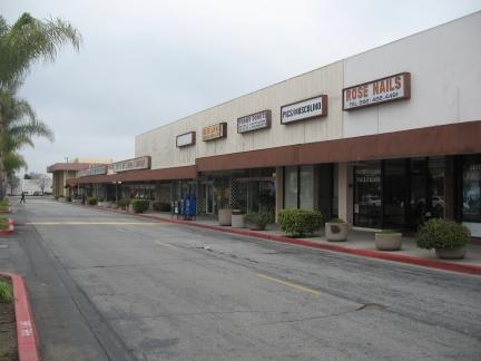
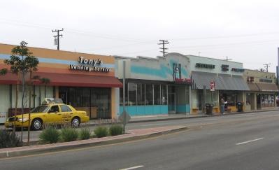
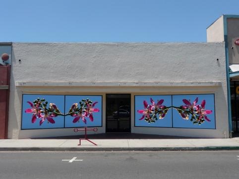
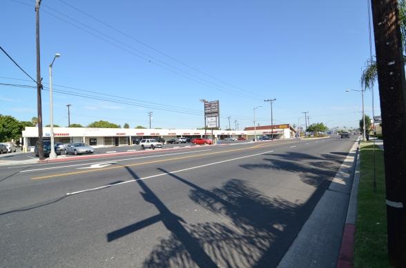
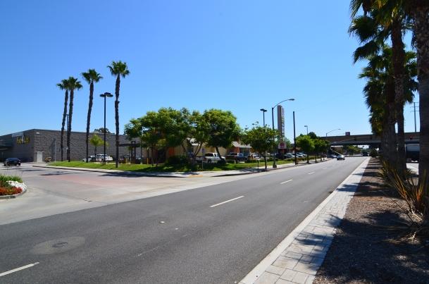
 Bixby Knolls on Long Beach Boulevard The retail corridor along Long Beach Blvd. in Bixby Knolls between Wardlow Road and Del Amo Blvd.")


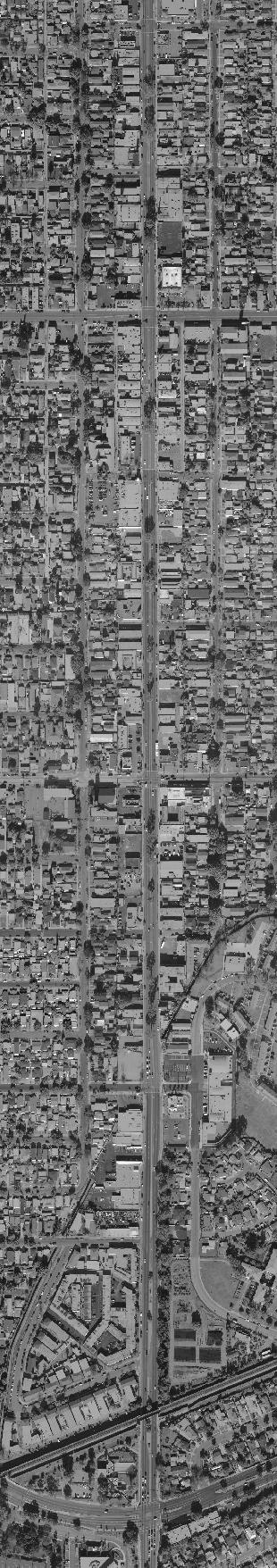
3 North Long Beach Corridor Investments Bixby Knolls on Long Beach Boulevard (Long Beach Blvd. - Wardlow Road to Del Amo Blvd.) Total Public Investment: $3.5 Million (FY FY2010) Bixby Knolls on Long Beach Boulevard The retail corridor along Long Beach Blvd. in Bixby Knolls between Wardlow Road and Del Amo Blvd. stands as the mature elder to its Atlantic Avenue sibling. Along this corridor a wide variety of business and professional services buildings have established and continue to grow amid handsome mid-century modern architecture. From doctors and lawyers to architects and developers, Long Beach Blvd. continues to provide top quality services to the local community and larger region. Similarly, the RDA continues to assist these businesses through commercial façade and major street and infrastructure improvements. Del Amo Blvd R ific Pac on Uni 5 oad ailr 1. Long Beach Blvd. Overlay Complete resurfacing of Long Beach Blvd. between Wardlow Road and San Antonio Drive. - Investment: $1 Million et Stre h t 6 4 eet 45th Str 2 d h Blv Beac Long ad Ro ina rig Vi n Sa 2. Long Beach Blvd. Overlay and New Medians Complete resurfacing of Long Beach Blvd. between San Antonio Drive and Del Amo Blvd. including new landscaped medians. - Investment: $2.1 Million D nio o t An e riv et tre ns rso Ca 3. Island Enterprises (4101 Long Beach Blvd.) Façade improvement included paint and stone facing on building. The owner has added to the improvement with signage, lighting and additional paint accents. - Investment: $50,000 3 Roosevelt Road Long Beach Blvd. Façade improvement included paint and signage on building. - Investment: $114,400 1 Bixby Road Locust Avenue Pine Avenue 4 37th Street 5. Johnny Rebs Inc. (4663 Long Beach Blvd.) Family restaurant serving authentic Southern food. - Investment: $200,000 (Revolving Loan) Linden Avenue 71 0F wy Elm Avenue Pacific Avenue 36th Street Wardlow Road Legend RDA LBHDC Façade Improvements/ Commercial Rebate/Fencing 34
 lvd ob m A Del 11 46th Street X9 45th Way Bixby Knolls on Atlantic Avenue The retail corridor along Atlantic Avenue in Bixby Knolls between Wardlow Road and Del Amo Blvd.")


4 North Long Beach Corridor Investments Bixby Knolls on Atlantic Avenue (Atlantic Avenue Fwy. to Del Amo Blvd.) Total Public Investment: $19.4 Million (FY FY2009) lvd ob m A Del 11 46th Street X9 45th Way Bixby Knolls on Atlantic Avenue The retail corridor along Atlantic Avenue in Bixby Knolls between Wardlow Road and Del Amo Blvd. has emerged as one of the City s greatest revitalization success stories. From its unique boutique shops and bustling restaurants to the grassroots, community driven art and entertain venue known as Gallery Expo, the area has reinvented itself to become the go to destination in North Long Beach. The RDA has worked hand in hand with local business either directly or through its cutting edge business improvement association, the Bixby Knolls Business Improvement Association to develop this one of a kind neighborhood. The RDA has similarly funded major streetscape, median and parkway landscaping improvements. 45th Street 56 n Sa D nio o t An e riv Atlantic Avenue Linden Avenue Elm Avenue 13 eet n Str o s r Ca Roosevelt Road 1. California 405 Freeway Signage In partnership with BKBIA and Cal Trans, purchased and installed nine wayfinding signs along the 405 Freeway indicating Bixby Knolls exit ramps. - Investment: $13, rd Street and Atlantic Avenue In partnership with the BKBIA, cleared, landscaped and fenced a vacant lot owned by Signal Hill Petroleum to improve a gateway site into the Bixby Knolls area. - Fencing Investment: $20, Expo Building (4321 Atlantic Avenue) Acquisition of a 19,100 square foot building on a 41,000 square foot parcel for future development. RDA entered into a lease agreement with BKBIA for interim use of the property as an arts and cultural venue in Acquisition: $5.1 Million Bixby Road 37th Street 36th Street 4. Bixby Knolls Business Improvement Association (BKBIA) (4313 Atlantic Avenue) Assist BKBIA with development and marketing opportunities with a focus on capital improvements, retail development and promotion of arts and cultural events throughout Bixby Knolls. - Investment: $138,600 (annually) Wardlow Road Legend 33rd Street 405 Fw y RDA LBHDC Façade Improvements/ Commercial Rebate/Fencing
5
6


7

 Legend RDA LBHDC Façade Improvements/ Commercial Rebate/Fencing 12 13 ic acif on P Uni d roa Rail 14X 47th Street Virginia Village Virginia Village is a")
 of North Long Beach.")

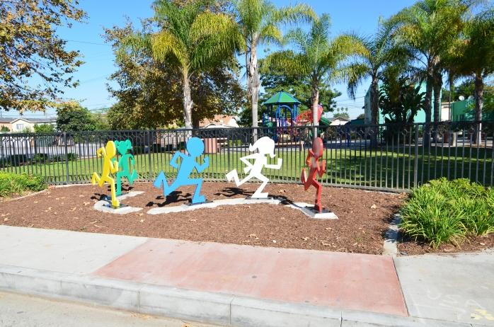
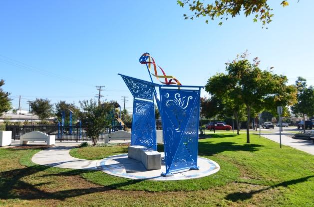
8 North Long Beach Corridor Investments Long Beach Boulevard (47th Street to 710 Fwy.) Total Public Investment: $30.1 Million Acquisition: $21.3 Million Chestnut Avenue South Street 56th Street 55th Street 7 Louise Street 2 5 Market Street Pacific Avenue Plymouth Street Pacific Avenue 1 52nd Street Sunset Avenue 51st Street Home Street 6 Del Amo Blvd Pleasant Street 10 49th Street 48th Street 11 nue Ave Daisy Avenue Cedar Avenue 53rd Street ham Gris Oregon Avenue Locust Avenue Ellis Street Pine Avenue d h Blv Beac Long Los An gel es Riv er 710 Fw y (FY FY2011) Legend RDA LBHDC Façade Improvements/ Commercial Rebate/Fencing ic acif on P Uni d roa Rail 14X 47th Street Virginia Village Virginia Village is a seven block pedestrian oriented neighborhood-serving commercial area adjacent to the intersection of Long Beach Blvd. and Market Street. Over the past five years, the RDA has undertaken and successfully completed numerous projects and programs in the Virginia Village area (historic core) of North Long Beach. Much of the RDA effort has concentrated on the acquisition and demolition of blighting influences. For example, the former El Paisano Bar located at 5368 Long Beach Blvd. was acquired in 2008 thereby ending years of numerous police service calls related violent crime and property damage. Central to the RDA improvements in the Village are extensive street reconstruction and decorative landscaping improvements, while façade and storefront renovation assistance have restored multiple buildings to their original period luster. 1. Long Beach Blvd. Streetscape Improvements (Del Amo Blvd. to 56th Street) Construction is currently underway on a streetscape improvement project along Long Beach Blvd. between Del Amo Blvd. and the 710 Freeway. Improvements include street resurfacing, decorative crosswalk pavers, new concrete sidewalks, street trees, historic light medallions, street lighting and a one-way traffic couplet at 56th Street and Ellis Street. - Investment: $8 Million 2. Virginia Village Commercial Façades (5300, 5304, 5306, 5318, 5322, 5344, 5350, 5351, 5353, 5355, 5358, 5360, 5362, 5366, 5413, 5415, 5417 & 5421 Long Beach Blvd.) In an effort to improve blighted commercial buildings in several locations in Virginia Village along Long Beach Blvd., façade improvement projects have been completed at the above addresses. Examples of façade improvements include: painting, new storefronts, awnings, signage, lighting and ADA upgrades. To date, focus has been on the rehabilitation of historic resources in the area. - Investment: $500, Long Beach Arts Inc. (5372 Long Beach Blvd.) A non-profit corporation, leases the RDA-owned property. The tenants use the building as gallery space to host seven to eight juried art exhibitions a year and also exhibit art from local and national artists. - Acquisition: $498, Open Space & Public Art The Redevelopment Agency acquired the properties located at 5368 and 5372 Long Beach Blvd. The Virginia Village Paseo is under construction and will connect the Virginia Village commercial area to the adjacent residential neighborhood. Improvements will include permeable brick paving, seating areas, landscaping, bicycle racks and lighting. - Acquisition: $983,000 - Investment: $150,000 39


9
10
11
12

13
14
15
16
Table of Contents. Elm Avenue Improvement Plan City of Waco, Texas. Introduction 1. Existing Context 1 Figure 1 2.
 Table of Contents Introduction 1 Existing Context 1 Figure 1 2 Plan Guidelines 3 Future Urban Form 4 The West-End 4 Main Street 6 The East-End 7 Figure 2 9 Public Improvement Recommendations 7 General
Pine Avenue Improvement Project
 Seaside Way to ocean Boulevard ocean Boulevard to 7 th Street 7 th Street to anaheim Street L O ng BeACh DeveLOpment ServiC e S Building a Better long Beach Pine Avenue Improvement Project Seaside Way
Carlsbad Village Redevelopment Concept Summary of Features
 Carlsbad Village Redevelopment Concept Summary of Features Calthorpe Associates November 5, 2003 The Redevelopment Concept illustrates a vision for the future of Carlsbad Village. The overall vision of
8 October 14, 2015 Public Hearing
 8 October 14, 2015 Public Hearing APPLICANT & PROPERTY OWNER: PRICE S HOLDINGS, LLC STAFF PLANNER: Karen Lasley REQUEST: A. Conditional Use Permit (Automobile Repair Garage) B. Change in Nonconforming
City of Long Beach. creating vibrant and exciting places
 City of Long Beach creating vibrant and exciting places Land Use Element Urban Design Element Overview of the two draft General Plan elements Discuss areas of change Economic goals of the plans Case study
The West College Avenue Corridor Redevelopment Plan
 The West College Avenue Corridor Redevelopment Plan Proposed dby Educational Property Group, Inc. & Apex Development Project Summary The intent of this proposal is to introduce market-driven mixed-use
Community Design Plan
 Gardena General Plan 2006 Authority While the is not a required element of a General Plan, it is included because improving the community appearance and image is paramount to the overall quality of life
The Lincoln Neighborhood Corridor Plan. The LiNC
 October 1, 2014 Planning Commission Study Session The Lincoln Neighborhood Corridor Plan The LiNC Purpose of Tonight s Meeting Introduction to The LiNC Review of Existing Conditions and Community Identified
GREENING THE BOULEVARD Master Plan Concepts for Venice Boulevard between Lincoln and Sawtelle
 GREENING THE BOULEVARD Katherine Spitz Associates Inc. 4212½ Glencoe Avenue Marina Del Rey, CA 90292 310 574 4460 Fax 574 4462 January 2008 Table of Contents Overview Proposed Design Improvements Illustration
Appendix A: Design Guidelines
 New development in West Oakland should aesthetically respond to the unique characteristics already found in the area, including the character of land uses and building types, thus honoring the culture,
PIKE PINE RENAISSANCE: ACT ONE. October 19, 2017
 PIKE PINE RENAISSANCE: ACT ONE October 19, 2017 WATERFRONT SEATTLE PROGRAM PROJECT INTRODUCTION Pike and Pine streets, between First and Melrose avenues Pedestrian and streetscape improvements Budget:
Activities for All Ages. Small Community Feel. Entertainment. Mix of Uses
 DRAFT PROPOSALS Safety Walkability Open Space/Views to Ocean/Beach Access Activities for All Ages Small Community Feel Entertainment Mix of Uses Gathering Place Celebrate Our Assets: Enhance the four major
Beachside Redevelopment Committee
 Beachside Redevelopment Committee DRAFT FINAL RECOMMENDATIONS MARCH 22, 2018 This is a new slide 2 This is a new slide Table of Contents I. Introduction and Overview II. III. Community Improvements and
Index to Projects by Project Name
 Index to Projects by Project Name Project # PROJECT NAME PAGE 2134 2119 PR-1109 Clayton Road (Market Street to Oakland Avenue) Sidewalk Repair 911 System Replacement and Dispatch Room Remodel ADA Barrier
Project Consulting Team:
 THE DOWNTOWN CHERRYVILLE LAND USE + STREETSCAPE MASTER PLAN WAS FUNDED THROUGH THE GENEROUS DONATIONS OF THE FOLLOWING: The Community Foundation of Gaston County ElectriCities of North Carolina The Cherryville
Town Center (part of the Comprehensive Plan)
") Town Center (part of the Comprehensive Plan) Mercer Island Town Center Looking North (2014) In 1994, a year-long process culminated in a set of design guidelines and code requirements for the Town Center
Town Center (part of the Comprehensive Plan) Mercer Island Town Center Looking North (2014) In 1994, a year-long process culminated in a set of design guidelines and code requirements for the Town Center
NWI Wetland Public Waters Inventory Low Density Residential Medium Density Residential. High Density Residential. Public or Institutional
 Map 1.1 Future Land Use Jennings Bay West Arm Dutch Lake Harrisons Bay Lake Langdon Seton Lake Emerald Lake Black Lake Cooks Bay Halstead Bay Priest Bay Phelps Bay NWI Wetland Public Waters Inventory Low
CHAPTER 8. Mrs. Zimman s Class - Central Elementary
 SUSTAINABILITY CHAPTER 8 Mrs. Zimman s Class - Central Elementary 8.1 OVERVIEW Green infrastructure also known as low impact development (LID) and environmental or sustainable site design is an environmentally
appendix and street interface guidelines
 appendix five: building and street interface guidelines appendix 5 building and street interface guidelines BOULEVARDS Boulevards are generally characterized by higher levels of traffic movement at higher
Spring 2018 Construction Update
 Spring 2018 Construction Update Ward 3 Southwest Engineering Department Locust Street Bridge over the Des Moines River The Locust Street Bridge over the Des Moines River project is being let through the
The transportation system in a community is an
 7 TRANSPORTATION The transportation system in a community is an important factor contributing to the quality of life of the residents. Without a sound transportation system to bring both goods and patrons
Pedestrian and Bike Bridge LOGO
 6.2.2 Pedestrian and Bike Bridge The proposed pedestrian and bike crossing re-envisions the existing bridge at Pismo Creek on Cypress Street. The bridge is currently underutilized by vehicular through
Status Update (2006 vs. Now) Citizen s Advisory Committee February Plan for Prosperity
 Citizen s Advisory Committee February Plan for Prosperity") Status Update (2006 vs. Now) Citizen s Advisory Committee February 2018 Plan for Prosperity 2000 2017 2000 2017 Gardnerville Population 6,000 5,760 5746 5,500 5,000 5,067 5,550 5,165 5,394 5,412 5,250
Status Update (2006 vs. Now) Citizen s Advisory Committee February 2018 Plan for Prosperity 2000 2017 2000 2017 Gardnerville Population 6,000 5,760 5746 5,500 5,000 5,067 5,550 5,165 5,394 5,412 5,250
City of Ennis. Downtown Master Plan Catalyst Projects
 City of Ennis Downtown Master Plan Catalyst Projects Revised Framework Plan REVISED Project Types and Descriptions Project Types A. Visitor Attracting Projects: Projects in this category are intended to
Corridors. Re-vitalize our Corridors and Gateways
 Corridors Re-vitalize our Corridors and Gateways Artist s rendering from the 287 Strategic Plan, 2015 Corridors are the major throughways of Loveland but they also provide important commercial, community
McLean Main Street Public Forum Exchange of Ideas
 McLean Main Street Public Forum Exchange of Ideas Sponsored & Hosted by McLean Planning Committee John W. Foust, Dranesville District Supervisor Fairfax County Office of Community Revitalization and Reinvestment
The Auburn Plan Designing the Future of Auburn February 28, 2005
 The Auburn Plan Designing the Future of Auburn February 28, 2005 Block-by-Block Bicycle Tour Aerial survey Focus Group Meetings September 7 and 8 Design Workshops October 11, 14, and 21 Revitalization
A larger version of this map is located on the last page of this PDF.
 MAP Committee Input McLoughlin Area Draft Vision Map A larger version of this map is located on the last page of this PDF. 1. The map above is intended to portray a vision for the McLoughlin area. It highlights
The Project. In 2013, construction was completed between 100 Street and 102 Street.
 The Project Jasper Avenue New Vision (JANV) is a major catalyst project identified in the Capital City Downtown Plan (2010) between 92 Street and 109 Street, including the streets half a block north and
WELCOME and introduction
 1 WELCOME and introduction Mobility Hub Locations within Burlington STUDY OVERVIEW STUDY OBJECTIVES The City of Burlington is developing four Area Specific Plans, one for each of Burlington s Mobility
Reinventing Miner Avenue as a
 Reinventing Miner Avenue as a Complete Street Reinventing Miner Avenue as a Complete Street Agenda Project Overview / Introductions Previous Meeting Recap Economic Considerations Opportunities & Constraints
2.0 PROJECT DESCRIPTION
 2.0 PROJECT DESCRIPTION The proposed project involves the redevelopment of an approximately 6.3-acre site in the City of Long Beach with a mixed-use village center project. This section describes the project
NORTH COLLEGE PARK. Residential Neighborhood and Neighborhood Center OBJECTIVES EXISTING SITUATION AND ISSUES CONCEPT
 Greenbelt Metro Area Sector Plan - Subarea Design Policies and Guidelines - North College Park 119 NORTH COLLEGE PARK Residential Neighborhood and Neighborhood Center CONCEPT North College Park is envisioned
DRAFT Civic Center Station Area Plan. Executive Summary
 DRAFT Civic Center Station Area Plan Executive Summary This project is funded in part through the Metropolitan Transportation Commission s Station Area Planning Program. The preparation of this report
Chapter 4: The Vision
 Chapter 4: The Vision This plan is organized around the community vision detailed in this chapter. The vision describes the collective thoughts, values, and hopes of the community for its future. The community
2. Form and Character. 2.1 Introduction. 2.2 The Downtown Addition Plan. 2.1 Introduction
 2.1 Introduction 2.1 Introduction This section of the Specific Plan describes and illustrates the desired form, character and uses of the Downtown Addition and explains the underlying design principles.
7Page 91 CLEMMONS COMMUNITY COMPASS 7 COMMUNITY CHARACTER
 7 Community Character The beauty of Clemmons won t necessarily be a reflection of our past, but our future. This quote from Comprehensive Plan Steering Committee member Wayne Dodson captures the essence
EXHIBIT A. Tax Increment Reinvestment Zone No. 1 (Town Center) First Amended Project Plan 1
 First Amended Project Plan 1") EXHIBIT A Tax Increment Reinvestment Zone No. 1 (Town Center) First Amended Project Plan 1 1 As amended by Resolution No. 2008-02-001(TR1R) of the Tax Increment Reinvestment Zone No.1, and approved to
EXHIBIT A Tax Increment Reinvestment Zone No. 1 (Town Center) First Amended Project Plan 1 1 As amended by Resolution No. 2008-02-001(TR1R) of the Tax Increment Reinvestment Zone No.1, and approved to
FACADE DESIGN GUIDELINES
 FACADE DESIGN GUIDELINES PREPARED FOR: OFFICE FOR COMMUNITY DEVELOPMENT OF THE ARCHDIOCESE OF PHILADELPHIA 1 Introduction: table of contents STOREFRONT: Page 4 Entrance and display space. Most active business
FDOT D4 Complete Streets
 FDOT D4 Complete Streets Context Sensitive Solutions Directs that complete street solutions will complement the context of the community. Collaborative approach to decision making, project development,
ROME WATERFRONT VILLAGE PROJECT NARRATIVE January 25, 2018
 January 25, 2018 The Rome Waterfront Village project is intended to foster the revitalization of the area between South James Street and Erie Boulevard north of the Erie Canal as well as improve public
City of Villages Parking Strategies. William Anderson, FAICP City Planning & Community Investment San Diego Parking Symposium July 14, 2006
 City of Villages Parking Strategies William Anderson, FAICP City Planning & Community Investment San Diego Parking Symposium July 14, 2006 City of Villages Strategy A hierarchy of walkable, mixed use districts
SECTION TWO: Urban Design Concepts
 SECTION TWO: Urban Design Concepts The Gardnerville Plan for Prosperity shapes economic opportunities presented by regional growth. The Urban Design Concepts provide policies and concepts for land use,
Vision Statement. District Objectives. Oakton Mixed-use District Vision and Objectives
 Vision Statement The Oakton Mixed-use District is a unique place in Des Plaines. Its traditional development pattern will be the foundation for improvements that help create a strong pedestrian environment
Figure BE-4: Urban Form - Corridors. Urban Form and Land Use. Page BE-24 Redwood City General Plan S A N F R A N C I S C O B A Y.
 and Land Use Bird Island S A N F R A N C I S C O B A Y Foster City Bair Island Belmont Greco Island San Carlos Veterans Blvd. El Camino Real Broadway Middleeld Rd. Menlo Park Woodside Rd. Features El Camino
Table L-1 Summary Action Strategy. Action Item Timing Status Responsible Agency
 CHAPTER 4: CIRCULATION ELEMENT ISSUE #1: MAJOR THOROUFARES AND TRANSPORTATION ROUTES A balanced transportation system for Fontana is provided that meets the mobility needs of current and future residents
Concluding Improvement Recommendations and Opinions of Probable Cost (calculated in may 2010 construction rates).
.") Pelican Bay Community Improvement Plan Traffic,JI Concluding Improvement Recommendations and Opinions of Probable Cost (calculated in may 2010 construction rates). D1 -A: Provide consistent signing, marking
Pelican Bay Community Improvement Plan Traffic,JI Concluding Improvement Recommendations and Opinions of Probable Cost (calculated in may 2010 construction rates). D1 -A: Provide consistent signing, marking
Somers Point Master Plan
 Somers Point Master Plan Progress Report and Public Meeting August 20, 2014 Master Plan Reexamination Municipal Land Use Law require that all municipalities reexamine their master plan every ten years.
Panama City Beach Community Redevelopment Agency Condo Con Property Owner Conference & Expo November 14, 2014
 Panama City Beach Community Redevelopment Agency Condo Con Property Owner Conference & Expo November 14, 2014 Front Beach Road CRA On November 30, 2000, the City created the Panama City Beach Community
Public Frontage Regulations Map
 2.4. PUBLIC FRONTAGE REGULATIONS The Public Frontage is the area between the face of the curb and the back of the sidewalk. It includes the sidewalk, street trees, street lighting, and any landscaped planting
Roosevelt Corridor. R e i n v e s t m e n t P l a n. Public Meeting Gilbert Elementary School May 12, :00 pm
 Roosevelt Corridor R e i n v e s t m e n t P l a n Public Meeting Gilbert Elementary School May 12, 2009 6:00 pm Agenda 6:00 6:10 6:25 6:40 6:55 7:00 Opening Comments Councilwoman Jennifer V. Ramos District
SITE PLANNING. USC Village will be a mixeduse urban environment. creating a common ground with the surrounding community. Our planning goals include:
 North University Park West 101 6 5 North University Park East 5 3 North of Jefferson University Village/ Cardinal/Century 4 110 Downtown Los Angeles University Park Academic Core 1 10 60 University Park
Planning Districts INTRODUCTION
 INTRODUCTION To facilitate detailed examination of development prospects for all areas of the community, Delano has been divided into 14 planning districts. The location of these planning districts is
R STREET CORRIDOR NEIGHBORHOOD Site Plan and Design Review Supplemental Guidelines Checklist
 R STREET CORRIDOR NEIGHBORHOOD Site Plan and Design Review Supplemental Guidelines Checklist Applicant s Name: Project Address: Phone: Email: Applicant shall fill out the design guidelines checklist for
The Warehouse District in West Palm Beach is comprised of approximately 85,000 square of previously underutilized warehouse / industrial buildings in
 The Warehouse District in West Palm Beach is comprised of approximately 85,000 square of previously underutilized warehouse / industrial buildings in downtown being reimagined and redeveloped into a thriving
AGENDA ACTION ITEMS INFORMATION ITEMS
 NOACA Bicycle and Pedestrian Advisory Council Meeting Friday, March 21 st, 2014 10:30 a.m. NOACA Office 1299 Superior Avenue Cleveland, Ohio 44114 Phone: (216) 241-2414; website: www.noaca.org AGENDA ACTION
The Village. Chapter 3. Mixed Use Development Plan SPECIFIC PLAN
 The Village SPECIFIC PLAN Chapter 3 3.1 INTRODUCTION 3.1.1 Purpose This Chapter describes the development regulations applicable to the Mixed-Use and Transit Center Planning Areas. These form-based regulations
FLORIN ROAD CORRIDOR Site Plan and Design Review Guidelines Checklist
 FLORIN ROAD CORRIDOR Site Plan and Design Review Guidelines Checklist Applicant s Name: Project Address: Phone: Email: Applicant shall fill out the design guidelines checklist for all guidelines applicable
José Campos Manager of Planning and Design Review SPUR San José Symposium October 12, 2018
 1 Transbay: Freeways to New Ways José Campos Manager of Planning and Design Review SPUR San José Symposium October 12, 2018 2 Transbay freeway land pre-1989 3 1989 Loma Prieta Earthquake 4 TRANSBAY c.
PLANNING AND DESIGN GUIDELINES FOR BLOCK C OF THE MT. DIABLO REDEVELOPMENT PROJECT AREA Adopted by Design Review Commission February 4, 2004
 PLANNING AND DESIGN GUIDELINES FOR BLOCK C OF THE MT. DIABLO REDEVELOPMENT PROJECT AREA Adopted by Design Review Commission February 4, 2004 The Walnut Creek Redevelopment Agency has an adopted plan for
STREETSCAPE IMPROVEMENTS - RECOMMENDATIONS
 STREETSCAPE IMPROVEMENTS - RECOMMENDATIONS Figure 4.3.1- A map of all of the recommended streetscape improvements. The key component of downtown s public realm, apart from its public spaces, is its street
BACKGROUND / DETAILS OF PROPOSAL
 8 APPLICANT AND OWNER: MISSION ENTERPRISES, L.L.C STAFF PLANNER: Kristine Gay REQUEST: Conditional Use Permit ( Eating and Drinking Establishment within 100 of Protected District ) ADDRESS / DESCRIPTION:
Land Use. Hardware Street Vendor Mixed-Use
 Land Use Definition Land Use is the way a piece of real estate is utilized. Existing, proposed, and adopted land uses all play a role in the planning process. Once a land use plan is adopted, the next
Commercial Node Plan Devine Street/Jackson Blvd. COLUMBIA, SC
 Commercial Node Plan Devine Street/Jackson Blvd. COLUMBIA, SC 9.17.13 AGENDA 1 Introductions 2 Project Update 3 Concepts 4 Recommendations 5 Next Steps Introductions Project Update Process 5-Phase Process
A Vibrant Downtown. Chapter 5 Cary Public Art Opportunities 31
 A Vibrant Downtown Cary s vision for Downtown is a unique, vibrant, dynamic, pedestrian friendly location; a regional destination and a place to live, work, and recreate, according to the 2001 Town Center
REQUEST FOR PROPOSALS (RFP) DEVELOPMENT OF CITY-OWNED PROPERTY LOCATED AT THE NORTHWEST CORNER OF OLIVE BOULEVARD AND MIDLAND BOULVARD
 DEVELOPMENT OF CITY-OWNED PROPERTY LOCATED AT THE NORTHWEST CORNER OF OLIVE BOULEVARD AND MIDLAND BOULVARD") REQUEST FOR PROPOSALS (RFP) DEVELOPMENT OF CITY-OWNED PROPERTY LOCATED AT THE NORTHWEST CORNER OF OLIVE BOULEVARD AND MIDLAND BOULVARD CITY OF UNIVERSITY CITY 6801 DELMAR BOULEVARD UNIVERSITY CITY, MO
REQUEST FOR PROPOSALS (RFP) DEVELOPMENT OF CITY-OWNED PROPERTY LOCATED AT THE NORTHWEST CORNER OF OLIVE BOULEVARD AND MIDLAND BOULVARD CITY OF UNIVERSITY CITY 6801 DELMAR BOULEVARD UNIVERSITY CITY, MO
NOVEMBER 2016 AARP IN ST. LOUIS & CITIZENS FOR MODERN TRANSIT PLACEMAKING STRATEGIES FOR ST. LOUIS TRANSIT DRAFT
 NOVEMBER 2016 AARP IN ST. LOUIS & CITIZENS FOR MODERN TRANSIT PLACEMAKING STRATEGIES FOR ST. LOUIS TRANSIT DRAFT SECTION 3 RECOMMENDATIONS AARP IN ST. LOUIS + CMT + ARCTURIS + THE INNIS GROUP 37 SECTION
PUBLIC FRONTAGE REGULATIONS MAP
 2.4. PUBLIC FRONTAGE REGULATIONS The Public Frontage is the area between the face of the curb and the back of the sidewalk. It includes the sidewalk, street trees, street lighting, and any landscaped planting
Index to Projects by Project Name
 Index to Projects by Project Name 2062 1701 & 1711 Concord Avenue Purchase and Demolition of Structures 85 1279 1024 UF-802 UF-803 Affordable Housing 77 Annual CIP/TIP Management Program 105 Arnold Industrial
8implementation. strategies
 PROGRAM STRATEGIES 8implementation strategies T he implementation actions of this chapter are designed to support and carry out the land use, economic development, transportation, urban design, and program
2-FRAMEWORK STRATEGY
 2-Framework Strategy 2-FRAMEWORK STRATEGY The Downtown Master Plan Update is based on a framework of organizational concepts that should guide investment in the area. All of the components of the plan
2 January 13, 2010 Public Hearing APPLICANT: AUTOBELL CAR WASH, INC
 REQUEST: Conditional Use Permit (car wash) 2 January 13, 2010 Public Hearing APPLICANT: AUTOBELL CAR WASH, INC PROPERTY OWNER: MESSER 1060 INDEPENDENCE BOULEVARD STAFF PLANNER: Carolyn A.K. Smith ADDRESS
Streets Vision
 streets 86 2.9 Vision : The Most Prevalent and Important Public Spaces Fixed routes of human travel have served as corridors for commerce and places for human interaction from the earliest trails and foot
Mount Rainier, Maryland Urban Design & Planning
 Mount Rainier Mixed-Use Town Center Development Plan Mount Rainier, Maryland Urban Design & Planning The Mixed-Use Town Center Development Plan articulates a future vision for downtown Mount Rainier through
A P P E N D I X B - O P P O R T U N I T Y S I T E S
 A P P E N D I X B - O P P O R T U N I T Y S I T E S OPPORTUNITY SITES As listed in the Land Use Element, the City has identified 15 Opportunity Sites expected to be the focus of change and revitalization
BUILDING SCALE AND SETBACKS 5 ELEMENTS:... 5 FAÇADES (COMMERCIAL/RESIDENTIAL) 5
 5") VISION STATEMENT 3 UTILIZATION OF THE GUIDELINES 3 IMPLEMENTATION 3 PROCEDURES FOR DESIGN REVIEW 3 LAND USE AND ZONING 4 LAND USE 4 ELEMENTS:... 4 ZONING 4 ELEMENTS:... 4 BUILDING SCALE AND SETBACKS 5
VISION STATEMENT 3 UTILIZATION OF THE GUIDELINES 3 IMPLEMENTATION 3 PROCEDURES FOR DESIGN REVIEW 3 LAND USE AND ZONING 4 LAND USE 4 ELEMENTS:... 4 ZONING 4 ELEMENTS:... 4 BUILDING SCALE AND SETBACKS 5
Town of Yucca Valley Capital Improvement Projects Report July 24, 2014
 Town of Yucca Valley Capital Improvement Projects Report July 24, 2014 SR 62 Traffic and Pedestrian Improvements from Apache Trail to Palm Avenue (PLHD) The project includes construction of curbs, gutters,
THEMES, VISION, + PRINCIPLES
 CHAPTER 2: THEMES, VISION, + PRINCIPLES This page intentionally left blank. 20 VISION DRAFT AUGUST 2018 2 2 THEMES, VISION, + GUIDING PRINCIPLES The Key Themes, Vision, and Guiding Principles presented
UNIVERSITY CITY AREA PLAN. Volume Two: Implementation Plan
 UNIVERSITY CITY AREA PLAN Volume Two: Implementation Plan Transforming the University City MSD into the vibrant, people-oriented place envisioned in the University City Plan will occur incrementally through
The Atlanta BeltLine. Quarterly Briefing March @atlantabeltline. Reynoldstown Senior Affordable Housing
 The Atlanta BeltLine Quarterly Briefing March 30, 2017 @atlantabeltline @atlantabeltline @atlantabeltline Reynoldstown Senior Affordable Housing Framework for a multi-use and transit corridor in the heart
M E M O R A N D U M SITE DATA
 Department of Community Planning & Economic Development 250 South 4 th Street, Room 300 Minneapolis, MN 55415-1385 M E M O R A N D U M TO: City Planning Commission, Committee of the Whole FROM: Lisa Steiner,
Municipality of Anchorage. Community Council Survey Capital Projects Needs Ranking Survey (ALPHABETICAL) Airport Heights
 Airport Heights") ANCHORAGE PARKS & RECREATION Nichols Park Design and improve neighborhood park 2008 Challenge Grant applicant. 2008 $500K State Grant for Neighborhood Parks. Tikishla Park Lighting, paved parking, hockey
ANCHORAGE PARKS & RECREATION Nichols Park Design and improve neighborhood park 2008 Challenge Grant applicant. 2008 $500K State Grant for Neighborhood Parks. Tikishla Park Lighting, paved parking, hockey
DRAFT. October Wheaton. Design Guidelines
 October 2011 DRAFT Wheaton Design Guidelines 2 Draft - Design Guidelines - Wheaton Sector Plan Contents 04 Section 1: Introduction 06 Section 2: Context 08 Section 3: Design Guidelines 09 Goal 1: Create
1.0 VISION STATEMENT. December 6, PRINCIPLES
 Vision Statement Lincoln Regional Airport 1.0 VISION STATEMENT 1.1 City LOCATION of AND OVERVIEW The Easton Lincoln Place Land Use Master Plan identifies the principles, goals, policies, and standards
TRANSIT NEIGHBORHOOD PLANS PROGRAM OVERVIEW
 TRANSIT NEIGHBORHOOD PLANS PROGRAM OVERVIEW OCTOBER 2017 Los Angeles Department of City Planning @LATNP and @Planning4LA Outline Introduction Policy Framework The Transit Neighborhood Plans Program Overview:
A Plan Enhancement Process for the Future of Howard Design Studio 2 May 28-30, The Howard Plan
 A Plan Enhancement Process for the Future of Howard Design Studio 2 May 28-30, 2011 The Howard Plan West of Pinecrest Future Land Use Plan Velp Corridor Land Use Analysis & Recommendations Duck Creek /Quarry
Rocky Mountain Public Media
 19 June 2018 Arapahoe Square Design Review #1 2101 Arapahoe Street, Denver, CO 80205 Rocky Mountain Public Media Table of Contents Gateway Corner Visualization...03 Arapahoe Square Map...04 Site Plan Boundaries
MEMORANDUM. I2 District Downtown Parking Overlay District 24,000 square feet /.55 acres. Industrial Employment District North Loop Small Area Plan
 Department of Community Planning & Economic Development 50 South 4th Street, Room 300 Minneapolis, MN 5545-385 MEMORANDUM To: City Planning Commission, Committee of the Whole Prepared By: Peter Crandall,
South Yonge Street Corridor
 South Yonge Street Corridor Streetscape Master Plan Study Draft Final Executive Summary Prepared by: January 2012 In Partnership with: Introduction The Future... Yonge Street is at the forefront of York
SUBJECT: PREDEVELOPMENT PLAN REVIEW OF PROJECT LOCATED AT 2632 EAST WASHINGTON BOULEVARD ('ST. LUKE MEDICAL CENTER')
") TO: FROM: Honorable Mayor and City Council Planning & Community Development Department SUBJECT: PREDEVELOPMENT PLAN REVIEW OF PROJECT LOCATED AT 2632 EAST WASHINGTON BOULEVARD ('ST. LUKE MEDICAL CENTER')
TO: FROM: Honorable Mayor and City Council Planning & Community Development Department SUBJECT: PREDEVELOPMENT PLAN REVIEW OF PROJECT LOCATED AT 2632 EAST WASHINGTON BOULEVARD ('ST. LUKE MEDICAL CENTER')
Planning Area & Context. Planning Goals. 1. Improve circulation and traffic. 2. Increase mutual trust and benefits
 Planning Area & Context Planning Goals 1. Improve circulation and traffic 2. Increase mutual trust and benefits 3. Design integrated streets/ buildings 4. Provide housing and mixed-uses 5. Create and enhance
VICTORIA DOWNTOWN DEVELOPMENT PLANNING
 VICTORIA DOWNTOWN DEVELOPMENT PLANNING A Vision & Guide for the Future Downtown Victoria thrives as a center for the community, offering a great mix of entertainment, culture, business, and recreational
City of Hermosa Beach Administrative Policy #
 City of Hermosa Beach Administrative Policy # SUBJECT: Living Streets Policy Date: Approved by: City Council Authority: Public Works Department & Community Development Department Mayor, PURPOSE The City
Corridor Beautification Partnership
 Corridor Beautification Partnership December 6, 2016 Lindsey Guindi, Director of Strategic Projects Lindsay Hackett, Staff Planner Stephanie Doland, Staff Planner Corridor Beautification Partnership FY
Complete Streets Master Plan for Downtown New Britain CRCOG Transportation Committee Meeting Monday, December 9, 2013
 CRCOG Transportation Committee Meeting Monday, December 9, 2013 Introduction Why the Project was Initiated About Downtown New Britain Master Plan Goals Master Plan Overview Master Plan Study Areas and
EXISTING COMPREHENSIVE PLAN
 EXISTING COMPREHENSIVE PLAN Town Center Land Use Element: V. LAND USE POLICIES Town Center Mercer Island's business district vision as described in "Your Mercer Island Citizen-Designed Downtown" was an
THE CIVIC DISTRICT DEVELOPMENT OPPORTUNITIES
 1 THE CIVIC DISTRICT DEVELOPMENT OPPORTUNITIES The Civic District is the physical and emotional heart of the downtown. It is also a major gateway into the central core, establishing the image and identity
CHAPTER 5 Public Realm Improvements
 5.1 OVERVIEW This chapter focuses on the public realm, that is, spaces within and directly adjacent to public rights-of-way (ROWs), including streets, Oso Creek, the rail corridor, and the freeway edge.
8 February 9, 2011 Public Hearing APPLICANT: 7-ELEVEN, INC.
 . 8 February 9, 2011 Public Hearing APPLICANT: REQUEST: Conditional Use Permit for an automobile service station with a convenience store ADDRESS / DESCRIPTION: 2448 Nimmo Parkway PROPERTY OWNER: COURTHOUSE
Parapet/Formliner/Fencing
 Parapet/Formliner/Fencing Cross Parapet/Formliner/Fencing Street Aesthetic Features Context The I-290 Phase I study is evaluating improvements along 13 miles of the Eisenhower Expressway, from west of