Meadowlily Footbridge Rehabilitation Municipal Class Environmental Assessment Schedule B Screening Report
|
|
|
- Loreen Allen
- 5 years ago
- Views:
Transcription
1 City of London Municipal Class Environmental Assessment Prepared by: AECOM York Street, Citi Plaza tel London, ON, Canada N6A 6K fax Project Number: Date: December, 2012
2 AECOM City of London Municipal Class Environmental Assessment Statement of Qualifications and Limitations The attached Report (the Report ) has been prepared by AECOM Canada Ltd. ( Consultant ) for the benefit of the client ( Client ) in accordance with the agreement between Consultant and Client, including the scope of work detailed therein (the Agreement ). The information, data, recommendations and conclusions contained in the Report (collectively, the Information ): is subject to the scope, schedule, and other constraints and limitations in the Agreement and the qualifications contained in the Report (the Limitations ); represents Consultant s professional judgement in light of the Limitations and industry standards for the preparation of similar reports; may be based on information provided to Consultant which has not been independently verified; has not been updated since the date of issuance of the Report and its accuracy is limited to the time period and circumstances in which it was collected, processed, made or issued; must be read as a whole and sections thereof should not be read out of such context; was prepared for the specific purposes described in the Report and the Agreement; and in the case of subsurface, environmental or geotechnical conditions, may be based on limited testing and on the assumption that such conditions are uniform and not variable either geographically or over time. Consultant shall be entitled to rely upon the accuracy and completeness of information that was provided to it and has no obligation to update such information. Consultant accepts no responsibility for any events or circumstances that may have occurred since the date on which the Report was prepared and, in the case of subsurface, environmental or geotechnical conditions, is not responsible for any variability in such conditions, geographically or over time. Consultant agrees that the Report represents its professional judgement as described above and that the Information has been prepared for the specific purpose and use described in the Report and the Agreement, but Consultant makes no other representations, or any guarantees or warranties whatsoever, whether express or implied, with respect to the Report, the Information or any part thereof. Without in any way limiting the generality of the foregoing, any estimates or opinions regarding probable construction costs or construction schedule provided by Consultant represent Consultant s professional judgement in light of its experience and the knowledge and information available to it at the time of preparation. Since Consultant has no control over market or economic conditions, prices for construction labour, equipment or materials or bidding procedures, Consultant, its directors, officers and employees are not able to, nor do they, make any representations, warranties or guarantees whatsoever, whether express or implied, with respect to such estimates or opinions, or their variance from actual construction costs or schedules, and accept no responsibility for any loss or damage arising therefrom or in any way related thereto. Persons relying on such estimates or opinions do so at their own risk. Except (1) as agreed to in writing by Consultant and Client; (2) as required by-law; or (3) to the extent used by governmental reviewing agencies for the purpose of obtaining permits or approvals, the Report and the Information may be used and relied upon only by Client. Consultant accepts no responsibility, and denies any liability whatsoever, to parties other than Client who may obtain access to the Report or the Information for any injury, loss or damage suffered by such parties arising from their use of, reliance upon, or decisions or actions based on the Report or any of the Information ( improper use of the Report ), except to the extent those parties have obtained the prior written consent of Consultant to use and rely upon the Report and the Information. Any injury, loss or damages arising from improper use of the Report shall be borne by the party making such use. This Statement of Qualifications and Limitations is attached to and forms part of the Report and any use of the Report is subject to the terms hereof. AECOM: AECOM Canada Ltd. All Rights Reserved. Rpt- Final Screening Report Docx


3
4 EXECUTIVE SUMMARY Background The Meadowlily Footbridge spans the south branch of the Thames River linking Meadowlily Road on both the north and south sides of the river. Refer to Figure EX1 - Footbridge Location. The structure was built in 1910 by the Hamilton Bridge Company and is one of the few surviving truss bridges, once common in the London area. Originally the footbridge was a vehicle traffic bridge but has been reduced to pedestrian and bicycle traffic only. Regular bridge inspections have reported that the footbridge is in fair to poor condition. City of London Council directives state, the Meadowlily Footbridge is to be recognized as an important cultural heritage resource that should be protected; and that the Meadowlily Footbridge be recognized, in perpetuity as a footbridge. In addition to the regular inspection reports, these directives led to the completion of a Restoration and Cultural Heritage Evaluation, completed by AECOM in The work completed as part of that study included: Encouraging public participation with the on-going Meadowlily Area Plan, by engaging bridge enthusiasts, and local environmental groups as well as other stakeholders. Cataloguing the Meadowlily Bridge historical significance through completion of a Cultural Heritage Evaluation Report (CHER), and ranking using the Ontario Ministry of Transportation (MTO) Heritage Bridge Evaluation and Rating System. Preparing rehabilitation rationales to restore the bridge s full cross-sectional width. Performing an in-depth structural inspection of all load carrying members. Reviewing all pertinent standards, codes and design details in order to recommend necessary upgrades to allow the site to continue usage as a footbridge. Identifying the economic feasibility of several footbridge rehabilitation alternatives. That work documented: The footbridge is of significant heritage value and is eligible to be designated under Part IV of the Ontario Heritage Act. The footbridge is eligible for listing in the Ontario Bridge List. The Heritage Bridge Evaluation Criteria (MTO system) is significant, scoring 74, (a bridge rating over 60 is considered provincially significant therefore the Meadowlily site is considered a significant heritage asset). The structure can be readily rehabilitated using contemporary rehabilitation techniques and materials. The footbridge is currently not being used to its full potential as the deck width is bisected by a chain link fence. Local concerns have been raised regarding illegal activities at the site. Rehabilitation, including improved lighting and access could be implemented while still restricting the use of the footbridge to pedestrian and bicycle usage. To bring the footbridge up to current code requirements, minor design alterations will be required to existing structural elements resulting in minor variances to the bridge. Significant structural alterations are required to increase the usability of the footbridge, decrease dead load, and increase the reliability of the structure. Rpt- Final Screening Report Docx i
5 HAMILTON ROAD CP RAIL MEADOWLILY FOOTBRIDGE MEADOWLILY ROAD COMMISSIONERS ROAD HIGHBURY AVENUE ¹ ,000 1, Metres MEADOWLILY FOOTBRIDGE REHABILITATION MUNICIPAL CLASS EA FIGURE EX1: FOOTBRIDGE LOCATION PN: DATE: NOVEMBER 2012 SCALE: AS SHOWN
6 As a result, The City of London has retained AECOM Canada Ltd. to undertake a Schedule B Municipal Class Environmental Assessment (Class EA) to address MEA requirements for alterations to a structure found to have cultural heritage value. Class EA Process Municipalities in Ontario, including the City of London, are subject to provisions of the Environmental Assessment (EA) Act and the requirement to prepare an Environmental Assessment for most public works projects. Based on the Class EA process, projects are classified as Schedule A, A+ B or C. The complexity of each project is based on the level of investigation, environmental effects, technical considerations and public/agency input, which may affect the selection of the project schedule. It is up to the proponent to determine and/or customize the planning process to meet the projects consultation and technical needs based on the complexity of issues. The MEA Class EA document identifies work undertaken to reconstruct or alter a structure or grading adjacent to it when the structure is over 40 years old, which after appropriate evaluation is found to have significant cultural heritage value, as a Schedule B project. To adequately address the technical and environmental needs associated with the Meadowlily Footbridge, AECOM has undertaken this study in accordance with Class EA Schedule B requirements (as amended in 2007 and 2011). This study was subject to Phases 1 and 2 of the Class EA process which included identifying the problem (deficiency) or the opportunity, identifying alternative solutions to address the problem/opportunity taking into consideration the existing environment, establishing a preferred solution, and taking into account review agency and stakeholder input. The scope of work completed, included the following: A review of all work previously completed for the Meadowlily Footbridge. A comparative evaluation of a series of rehabilitation methodologies that lie between do nothing and replacement of the bridge. Identification of the preferred solution. Confirmation of minor ditch erosion issues associated with Meadowlily Road within the study area. Details will be further developed during detailed design. Identification of new pathway approaches in the immediate vicinity of the bridge, including turn-around geometry and restrictions to the footbridge, river and flood plain. Details will be addressed as part of detailed design. Completion of a Screening Report, documenting a summary of the rationale, planning, design and consultation process undertaken to establish the preferred solution. This report will be placed on public record for the mandatory thirty (30) day review period for public and agency comment. The following issues have been considered during this study. There is no significant need or benefit in opening the footbridge to vehicle traffic. The road network surrounding the footbridge location already includes several multi lane arterial roads and local street patterns that are utilized efficiently to move large amounts of vehicle traffic. The footbridge site does not need to be designed to carry vehicle traffic or other utilities other than those required for snow plowing and maintenance vehicles. The design will consider some form of physical access control to ensure usage is limited to pedestrians and bicycles. The site will be a significant destination for pedestrians and cyclists, therefore signage and lighting will be considered. Rpt- Final Screening Report Docx ii
7 The rehabilitation work will include deck replacement, installation of new railings and recoating of the superstructure (trusses). It is the intent to implement an alternative such that no in-water work is required. It is also the intent that all physical work will be contained in the City s right-of-way limits where possible. The assessment and mitigation measures will be of sufficient scope and detail to gain the required approvals and authorizations required. Crime Prevention Through Environmental Design (CPTED) principles will be implemented where possible to improve safety and reduce vandalism. This study is budgeted for 2012, with construction to be completed in This process served as a mechanism to understand environmental, social, technical and economic issues prior to implementing improvements or changes to the structure. Recommendations have been identified and a preferred solution has been selected based on a comparative evaluation, taking into consideration the natural, social, technical and economic environments. Public Consultation Public involvement is an important part of the study process therefore, several steps have been completed to inform relevant agencies, affected landowners, Aboriginal communities and members of the public about the project and to solicit their comments. The following mandatory points of contact as well as specific methods for contacting and consulting with stakeholders were undertaken. These included: Direct mailing to affected land owners and review agencies regarding notice of project milestones; including Notice of Project Commencement (August 20, 2012), Notice of Public Information Centre (PIC) (October 16, 2012), Notice of Public Participation Meeting at Civic Works Committee (CWC) scheduled for December 3, 2013 (November 14, 2012) and Notice of Completion (December 12, 2012). All notifications and documentation have been posted on the City of London website at: Consultation with Aboriginal communities to determine the potential effect on their lands/treaty rights and their interest in the study was carried out through direct correspondence and telephone calls to the Ministry of Aboriginal Affairs, Aboriginal Affairs and Northern Development Canada and local councils (Chippewas of the Thames, Oneida Nation of the Thames, Aamjiwnaang, Caldwell First Nation, Munsee-Delaware Nation, Bkejwanong Territory, Delaware Nation and Chippewas of Kettle & Stony Point). Consultation with review agencies (MOE, MNR, and UTRCA) was carried out through direct correspondence and meetings were held on September 20, 2012 with MOE and on September 28, 2012 with the UTRCA. A Crime Prevention Through Environmental Design (CPTED) review was held on site with London Police Services on October 19, A Public Information Centre was held on November 1, 2012 to provide background information on the project, an overview of the Class EA process being followed, identification and evaluation of the alternative solutions considered and the preferred solution. Notices for all project milestones were published as follows: o Notice of Project Commencement (2 publications in the London Free Press September 1 and September 8, 2012). Rpt- Final Screening Report Docx iii
8 o o Alternative Solutions Notice of Public Information Centre (2 publications in The Londoner - October 18 and October 25, 2012). Notice of meeting before Civic Works Committee (2 publications in The Londoner - November 15 and November 22, 2012). o Notice of Completion (2 publications in The Londoner December 20 and December 27, 2012) DO NOTHING Under this alternative, no measures to improve the condition of the structure are considered and the footbridge remains in its present condition. To best address the deterioration of the footbridge and identify appropriate measures to improve its structural integrity, the following alternative solutions have been considered. REHABILITATION OF THE EXISTING FOOTBRIDGE Rehabilitation of the footbridge using either historic or contemporary materials or techniques would be undertaken. The full width of the footbridge would be open to pedestrian/bicycle traffic. Supplemental concrete supports would be removed and selective repairs would be performed. PARTIAL REHABILITATION AND REPLACEMENT Partial rehabilitation of sections of the footbridge and partial replacement of the pony trusses would be completed. New footings would be required. The full width of the footbridge would be open to pedestrian/bicycle traffic. REPLACE THE EXISTING BRIDGE Replace the existing footbridge with a new footbridge that complies with acceptable design standards. Evaluation Process To assess the suitability of each alternative solution, a qualitative evaluation was used to identify significant advantages and disadvantages with respect to specific evaluation criteria developed for each environmental component (economic, social/cultural, natural environment, and technical). After the various evaluation criteria were developed, they were then applied to each of the alternative solutions to identify their potential effects on the environment. To provide an impartial, traceable and consistent evaluation, as required by the Class EA process, the following was used to illustrate the highest and lowest impact of each alternative relative to the evaluation criteria for each environmental component. A green circle illustrates the least negative impact or the most preferred alternative, while a red circle illustrates the highest negative impact or the least preferred alternative. Most preferred least negative impacts Some benefits, some negative impacts Least preferred most negative impacts The evaluation of alternatives has been captured in a matrix format to allow for direct comparison between the alternative solutions. Refer to Figure EX2 - Evaluation of Alternative Solutions. Rpt- Final Screening Report Docx iv
9 Municipal Class Environmental Assessment Figure EX2 Evaluation of Alternative Solutions Evaluation of Alternative Solutions Options CRITERIA Social/Cultural Impacts Public Health & Safety Cultural Heritage Resources Aesthetics First Nation/Aboriginal Issues OPTION 1 Do Nothing No improvements or changes would be made to the footbridge. Footbridge will continue to deteriorate overtime with increased risk to public safety. Vandalism, graffiti would likely continue. Important cultural heritage value could be lost due to continued deterioration of structure. Current retrofit items (i.e. sono tube, chain link fence) detract from footbridge aesthetics. No known impacts to First Nation/Aboriginal issues. OPTION 2A Historic Rehabilitation Restoration will eliminate existing fence, help reduce graffiti, and improve safety. Improvement to safety through design features (removal of some vegetation and improved lighting). Historic accuracy may not be compliant with Canadian Highway Bridge Design Code. Footbridge would be restored to its original or similar aesthetic condition. No known impacts to First Nation/Aboriginal issues. OPTION 2 Footbridge Restoration OPTION 2B Contemporary Rehabilitation Restoration will eliminate existing fence, help reduce graffiti, and improve safety. Improvement to safety through design features (removal of some vegetation and improved lighting). Rehabilitation would be compliant with the Canadian Highway Bridge Design Code. Footbridge would be restored to its original or similar aesthetic condition. No known impacts to First Nation/Aboriginal issues. OPTION 3 Partial Rehabilitation/Partial Replacement Restoration will eliminate existing fence, help reduce graffiti, and improve safety. Improvement to safety through design features (removal of some vegetation and improved lighting). Rehabilitation would be compliant with the Canadian Highway Bridge Design Code. Footbridge restored to its original or similar aesthetic condition. No known impacts to First Nation/Aboriginal issues. OPTION 4 Footbridge Replacement Restoration will eliminate existing fence, help reduce graffiti, and improve safety. Improvement to safety through design features. (removal of some vegetation and improved lighting). Rehabilitation would be compliant with the Canadian Highway Bridge Design Code. Loss of culturally significant structure. No know impacts to First nation/aboriginal issues. Natural Environmental Terrestrial Wildlife & Vegetation Aquatic Life & Vegetation Terrestrial and aquatic conditions remain as is. No improvements to vegetation conditions immediately surrounding the footbridge (i.e. no removal of invasive species). Potential impacts to terrestrial and aquatic habitat if footbridge fails completely and falls into the river. No agency approvals required. No in water works, therefore, no agency approvals in terms of aquatic habitat. No disruption of aquatic Species at Risk habitat. No loss of riparian vegetation along shoreline. Potential loss of mature trees through construction of turn-around areas. Trees lost include Manitoba maple and crack willow. Terrestrial habitat improvements can be implemented (i.e. invasive plant species removals). No in water works, therefore, no agency approvals in terms of aquatic habitat. No disruption of aquatic Species at Risk habitat. No loss of riparian vegetation along shoreline. Potential for loss of mature trees through construction of turn-around areas. Trees lost include Manitoba maple, black walnut and crack willow. Terrestrial habitat improvements can be implemented (i.e. invasive plant species removals). Potential for loss /disruption of fish habitat through construction of new footings. Permits under the Endangered Species Act may be required. In-water works required. Approval through DFO/UTRCA/MOE regulations required. Potential for loss of mature trees and riparian habitat through construction of turn-around areas and footbridge improvements. Trees lost include Manitoba maple, black walnut and crack willow. Terrestrial habitat improvements can be implemented (i.e. invasive plant species removals). Potential for loss /disruption of fish habitat through construction of new footings and new footbridge. Permits under the Endangered Species Act required. In-water works required. Approval through DFO/UTRCA/MOE regulations required. Potential for loss of mature trees and riparian habitat through construction of turn-around areas and footbridge improvements. Trees lost include Manitoba maple, black walnut and crack willow. Terrestrial habitat improvements can be implemented (i.e. invasive plant species removals). Technical/ Engineering Design (materials, substructure, trusses, deck) Construction Operation & Maintenance Applicable Policies/Approvals Economic Initial Capital Costs Operating & Maintenance Costs Degradation of existing footbridge will continue. No construction related impacts to adjacent community. No conflict with existing utilities. Existing footbridge has load limitations which are consistent with council resolution to preserve footbridge for pedestrian/bike traffic only. Ongoing maintenance required as footbridge continues to deteriorate. No agency approvals required. Loss of integrity may cause pieces of structure to fall in the river requiring salvaging costs. Does not comply with council directive to recognize Meadowlily Footbridge as an important cultural heritage resource that should be protected. This site has outlived its predictable service life. No associated capital cost as nothing would be implemented. Potential for ongoing operation and maintenance issues as footbridge deteriorates. Replacement materials will require ongoing maintenance regime. Potential for construction related impacts to adjacent community. Original footbridge geometry will be preserved. Existing footbridge has load limitations which are consistent with council resolution to preserve footbridge for pedestrian/bike traffic only. Some structural/architectural elements have residual life. Footbridge can be accessed using light machinery and platforms for restoration work. Non-destructive testing of all rivet connections required (costly). Additional construction time required for riveting. Opportunity to install hand rail to current building code and sympathetic to original design aesthetics. 50 year service life of footbridge. High durability restoration with typically low maintenance. Painting required every 30 years. Skid steer required to access flood plain area. Longest length of footbridge closure. The availability of skilled labour could be a potential issue. Existing hydro line would be undisturbed. Full width of deck will be restored. Full footbridge enclosure required for painting. Agency approvals required. Moderate capital costs. High risk of additional cost increases due to small skill market for specialty labour force (riveting). Low operation and maintenance costs. Replacement materials require ongoing maintenance regime. Potential for construction related impacts to adjacent community. Original footbridge geometry will be preserved. Existing footbridge has load limitations which are consistent with council resolution to preserve footbridge for pedestrian/bike traffic only. Opportunity to install hand rail to current building code and sympathetic to original design aesthetics. Some structural/architectural elements have residual life. Footbridge can be accessed using light machinery and platforms for restoration work. 50 year service life of footbridge. High durability restoration with typically low maintenance. Painting required every 30 years. On-site construction with minimal preassembly. Skid steer required to access flood plain area. Footbridge closure required. Use of round head bolts similar to rivets but process quicker, more reliable and cost effective. Existing hydro line would be undisturbed. Full width of deck will be restored. Full footbridge enclosure required for painting. Agency approvals required. Lowest capital costs. Potential for additional construction costs due to retrofitting existing structure. Low operation and maintenance costs. Replacement materials require ongoing maintenance regime. Potential for construction related impacts to adjacent community. Potential to design wider deck. Potential to add enhanced architectural features. Removal and replacement of existing pony trusses may be quicker than rehabilitation. Access road required for installation of pony trusses and footings. Opportunity to install hand rail to current building code and sympathetic to original design aesthetics. Increased service life with use of new materials. 50 year service life on main span/80 years on pony truss. Footbridge painting required every 30 years. Elimination of expansion joints can defer major repairs. Access road will be required during the installation of new footings and pile driving. Footbridge closure will be required. Timing of substructure removal will be dependent on ecological conditions and construction windows for aquatic species. Replacement of the existing hydro line would be required. Full width of deck will be restored. Full footbridge enclosure required for coating. Agency approvals required. Moderate to high capital costs. Low risk for construction cost increases. Potential for additional dewatering and environmental costs. Low operation and maintenance costs. Replacement materials require maintenance regime. Potential for construction related impacts to adjacent community. Replacement materials will reduce dead loads. Increased service life with use of new materials. Opportunity to install hand rail to current building code and sympathetic to original design aesthetics. Temporary road required to access centre piers during construction. Dewatering of foundation elements will require settling pond placement, removal and remediation. Mobilization of pile driving and heavy lifting equipment would be required. Full width of original footbridge width can be restored. Longest service life. Footbridge closure will be required. Timing of construction will be dependent on ecological conditions and construction windows for aquatic species. Does not comply with council directive to recognize Meadowlily Footbridge as an important cultural heritage resource that should be protected. Agency approvals required. Highest capital costs. High risk for additional construction costs due to the depth of foundation. Low operation and maintenance costs.
10 Public Comments Received Prior the public open house three (3) written comments and one (1) voice mail were received. These comments included the following. Confirmation as to whether the recommendations would be brought forward to the Civic Works Committee and Council. Clarification on how the Class EA process will be incorporated with the work previously completed for Meadowlily Footbridge. As property owners of the Meadowlily Nature Preserve the Thames Talbot Land Trust expressed their interest in the project, and all matters relating to their property and their neighbours. Confirmation of the cost and feasibility of installing a surveillance camera on the south side of the bridge to improve safety. The Public Open House was held on November 1, Fifteen people (15) were in attendance and four (4) comments sheets were received by the November 16, 2012 deadline. No significant issues were identified. The comments received have been categorized into different themes which are briefly summarized below. Safety Residents generally want a safe footbridge to cross for all users. There were concerns relating to the number of vehicles broken into while parked along Meadowlily Road. A resident inquired about the cost and feasibility of installing a surveillance camera at the south side of the footbridge. Another resident suggested the installation of LED solar lights at the footbridge. A concern was also raised that if the railing similar to the King Street Bridge was to be installed, people would have more accessibility to climb the trusses. Environmental Impacts Clarification was provided to a resident that no trees within the ESA will be removed in order to construct the parking along Meadowlily Road. A request was made to have the lowest footprint possible on the south side of the footbridge by not encroaching into the ESA and to not disturb the large trees fronting along Meadowlily Road South. A comment was received regarding light pollution resulting from increased lighting on and around the footbridge. It was noted by several residents that overland flow has caused erosion and icing in the winter months, south of the study area. Alternative Solutions Those in attendance at the PIC strongly supported rehabilitation of the footbridge. It was noted that the Do Nothing and Replace the Bridge alternatives were not acceptable. Design Details A preference to install a railing similar to what was used for the King Street Bridge was brought forward. It was suggested that this type of railing is more compatible with a heritage structure. Rpt- Final Screening Report Docx v
11 One suggestion was for the addition of the original inscription plates to be incorporated into the flooring of the new footbridge. Installing a depth gauge to measures the water depth was also suggested. A resident inquired about the possibility of installing a temporary footbridge for pedestrians and cyclists during construction. Signage at Commissioners Road and Hamilton Road was recommended to indicate the location of the bridge as well as signage at the bridge indicating the location of the former Meadowlily Mill. A sign on the footbridge was also suggested that would identify the original date of construction and the bridge builder. General Several comments received from residents related specifically to construction timing, duration, footbridge closure and the possibility of expediting the process in order to complete the bridge rehabilitation as soon as possible. One group expressed their support for the rehabilitation of the bridge as outlined at the PIC. No comments have been received from Aboriginal communities. A public participation meeting was held before the Civic Works Committee on December 3, A brief presentation was made by City staff and AECOM to present the recommendations to the Committee for their endorsement. Members of the public had an opportunity to provide their input. Friends of Meadowlily Woods Community Association made a formal presentation to the committee requesting consideration of footbridge signage design and location. The association also expressed support of proposed tree removal adjacent to the footbridge, but raised concerns about the removal of any other trees. A member of the public inquired as to how the City will address path detours while the footbridge is not useable to pedestrians and cyclists. A member of the public asked about having a temporary bridge installed for use during rehabilitation of the existing footbridge. Cost and timing were given as the reasons for a temporary footbridge to not be provided. The resident also suggested the use of surveillance cameras on Meadowlily Road South to deter car break-ins. Details of all public consultation are located in Appendix G. Conclusions & Recommendations The City of London has evaluated all viable alternatives to address the deterioration of the Meadowlily Footbridge and improve its structural integrity. Option 2B Footbridge Rehabilitation using Contemporary Materials and Techniques has been recommended as the preferred solution for the following reasons. The culturally significant structure will be retained. The dead load will be reduced on the footbridge. The existing chain link fence will be removed. The footbridge deck will be restored to its full width. The design will incorporate some of the CPTED principles for safety. The rehabilitated structure will be highly durable (anticipated service life of the restored structure is approximately 50 years). Low maintenance materials will be used. Rpt- Final Screening Report Docx vi
12 This is the lowest cost alternative. There will be limited tree/vegetation removal required. No in-water work is required. Although contemporary materials will be used, the footbridge will maintain an historic appearance. Refer to Figure EX3 - Preferred Solution As part of this project, the north and south approaches to the footbridge have been considered in the overall design of the area. Upgrades to the immediate approach areas of the footbridge are proposed as follows: Both north and south approaches to the footbridge will be enhanced. Multi-use paths will be delineated with painted markings to guide users. Lighting on the bridge will be improved. Removable barriers and bollards will be implemented at the approaches to the footbridge to discourage vehicular traffic across the footbridge but will allow access for snow removal. Limited tree/vegetation removal is necessary to accommodate new path alignment and turn-arounds. Parking spaces will be provided at both ends of the footbridge on Meadowlily Road. Refer to Figure EX4 Turn-around and Parking. The footbridge rehabilitation will consist of the removal and reattachment of several key structural elements, painting, re-decking with a wooden deck which will not permit staging of construction. The footbridge deck will be completely impassable to pedestrian and bicycle usage and will be closed for the duration of construction.. A temporary footbridge would pose significant challenges and is an expensive addition to the project for the following reasons: For clearance and hydraulic opening requirements, the temporary footbridge would have to be similar in size to the existing footbridge. The location of a temporary footbridge would require separation from the existing footbridge to accommodate appropriate work space and safety considerations. A temporary footbridge would intrude into the ESA and involve in water work, both requiring environmental approvals. As a result adherence to construction windows to avoid periods of spawning, migration and other critical life history stages for habitat would be required. These timing windows are applied to protect fish from any works in and around water, resulting in a construction start after July 15, This would impact the start of construction by up to three (3) months and jeopardize the ability to complete the bridge rehabilitation in one season and in the 2013 calendar year. Approach work to the temporary structure would require extensive removals and rehabilitation. The cost of the temporary bridge would be approximately $700,000. As a result during construction a temporary footbridge has not been recommended. Preliminary Cost Estimate The preliminary cost estimate for the Meadowlily Footbridge rehabilitation is approximately $1.9M. This is based on the Restoration and Cultural Heritage Evaluation Report (2011) previously completed and will be confirmed as part of detailed design. Rpt- Final Screening Report Docx vii

13
14 North Approach South Approach MEADOWLILY FOOTBRIDGE REHABILITATION MUNICIPAL CLASS EA FIGURE EX4: Turn-around and Parking PN: DATE: NOVEMBER 2012 SCALE: AS SHOWN
15 Schedule Subject to Council approval, the following schedule has been identified: Class Environmental Assessment thirty (30) day review period: December 21, January 25, 2013 (extra time added due to Christmas Closure); Detailed design: December 2012 February 2013; Pre-construction PIC: February 6 or 7, 2013; Project tendering: February 14 March 5, 2013 Tender award recommendation to Civic Works Committee and Council: April 8/April 16, 2013 respectively; Start of construction: April 29, 2013; and Completion of the work is anticipated at the end of October or November Rpt- Final Screening Report Docx viii
16 Table of Contents Statement of Qualifications and Limitations Distribution List Executive Summary 1. Introduction Report Format Project Overview Project Objectives Municipal Class Environmental Assessment Process Types of Projects Class Environmental Assessment Phases Consultation and Communication Program Project Need and Justification Identification of the Problem Justification Existing Conditions Physical Site Conditions Cultural/Heritage Environment Cultural Assessment Historical Value Contextual Value Archaeological Assessment Natural Environment Aquatic Conditions Terrestrial Conditions Species at Risk Technical Environment Visual and Ultrasonic Inspection Structural Analysis Hydraulic Analysis Policy and Approvals The Planning Act Provincial Policy Statement Official Plan Upper Thames River Conservation Authority Ministry of Natural Resources Ministry of the Environment Alternative Planning Solutions Alternative Solutions Evaluation Framework and Criteria Consultation Agency Consultation Public Consultation page Rpt- Final Screening Report Docx
17 5.3.3 Aboriginal Consultation Preliminary Recommended Solution Preferred Solution Conceptual Design Details Environmental Recommendations Archaeological Recommendations Permits and Approvals Construction Mitigation Measures Monitoring Preliminary Costs Class EA Project Completion Filing Procedure Notification of Completion List of Figures Figure 1.1 Figure 2.1 Figure 2.2 Figure 4.1 Figure 4.2 Figure 5.1 Figure 5.2 Study Area Municipal Class EA process Consultation Process Schedule A: Land Use Schedule B1: Natural Heritage Features Preferred Solution Preliminary North/South Turn-around and Parking List of Tables Table 5.1 Table 5.2 Table 5.3 Table 5.4 Table 5.5 Environmental Components Evaluation Criteria Evaluation of Alternatives Summary of Comments Summary of Aboriginal Consultation Appendices Appendix A Appendix B Appendix C Appendix D Appendix E Appendix F Appendix G Appendix H Appendix I Request for Proposal Meadowlily Footbridge Restoration and Cultural Heritage Evaluation Study Council Resolution Stage 1 Archaeological Assessment Natural Environment Background Information Hydraulic Analysis Consultation Heritage Alteration Application Report Notice of Completion Rpt- Final Screening Report Docx
18 1. Introduction The City of London (City) has initiated a Municipal Class Environmental Assessment (EA) to rehabilitate the Meadowlily Footbridge which spans the Thames River in the City s southeast area. The project is being proposed as a measure to ensure the footbridge remains safe and intact while also enhancing the character of the community. AECOM Canada Ltd. (AECOM) has been retained by the City to complete this Municipal Class EA in accordance with the requirements for Schedule B projects as described in the Municipal Engineers Association s Municipal Class Environmental Assessment document (October 2000, as amended in 2007 and 2011) and as outlined in the Request for Proposal 4-FB-02 (Appendix A). This report has been prepared to provide members of the public, special interest groups, Aboriginal communities and government agencies a structured overview of the screening process to ensure that Municipal Class EA requirements have been met. 1.1 Report Format As noted above this report presents the planning and public consultation work completed for the project. It includes: Overview of the project; Project objectives; Project requirements; Overview of the Class EA process; Identification and description of the problem; Overview of existing environmental conditions; Identification, development and evaluation of solutions; Correspondence related to the project; Public consultation details; A description of the preferred solutions and, Conceptual design and recommended mitigation and compensation measures for the preferred solution. 1.2 Project Overview The Meadowlily Footbridge is a three span steel truss bridge that spans the south branch of the Thames River linking Meadowlily Road on both the north and south sides of the river. See Figure 1.1 Footbridge Location. The main span is a double intersection Warren truss and the southerly approach spans are pony trusses. The structure was built in 1910 by the Hamilton Bridge company and is one of the few surviving truss bridges, once common in the London area. Originally the bridge was a vehicle traffic bridge but has been reduced to pedestrian and bicycle traffic only. Regular bridge inspections have reported that the footbridge is in fair to poor condition. City of London Council directives state, the Meadowlily Footbridge is to be recognized as an important cultural heritage resource that should be protected; and that the Meadowlily Footbridge be recognized, in perpetuity as a footbridge. In addition to the regular inspection reports, these directives led to the completion of a Restoration and Cultural Heritage Evaluation Study, completed by AECOM in 2011 (Refer to Appendix B). That work included: Encouraging public participation with the on-going Meadowlily Area Plan, by engaging bridge enthusiasts, and local environmental groups as well as other stakeholders. Cataloguing the Meadowlily Bridge historical significance through completion of a Cultural Heritage Evaluation Report (CHER), and ranking using the Ontario Ministry of Transportation (MTO) Heritage Bridge Evaluation and Rating System. Rpt- Final Screening Report Docx 1
19 HAMILTON ROAD CP RAIL MEADOWLILY FOOTBRIDGE MEADOWLILY ROAD COMMISSIONERS ROAD HIGHBURY AVENUE ¹ ,000 1, Metres MEADOWLILY FOOTBRIDGE REHABILITATION MUNICIPAL CLASS EA FIGURE 1.1: FOOTBRIDGE LOCATION PN: DATE: NOVEMBER 2012 SCALE: AS SHOWN
20 Preparing rehabilitation rationales to restore the bridge s full cross-sectional width. Performing an in-depth structural inspection of all load carrying members. Reviewing all pertinent standards, codes and design details in order to recommend necessary upgrades to allow the site to continue usage as a pedestrian bridge. Identifying the economic feasibility of several bride rehabilitation alternatives. That work documented that the footbridge is of significant heritage value and as a result, The City of London has retained AECOM to undertake a Schedule B Municipal Class Environmental Assessment (Class EA) to address MEA requirements for alterations to a structure found to have cultural heritage value. The Municipal Class EA process provides the mechanism to consider various footbridge alternatives and develop a preferred solution that meets the criteria established for this project. It also provides an opportunity for public involvement, to gauge public support, increase public awareness, and to incorporate all substantive issues and concerns at the site into the recommended solution. 1.3 Project Objectives The objective of this project is to apply the requirements of the MEA Municipal Class EA guidelines for alterations to a structure found to have cultural heritage value. The scope of work completed, includes the following: A review of all work previously completed for the Meadowlily Footbridge; A comparative evaluation of a series of rehabilitation methodologies that lie between do nothing and replacement of the footbridge; Identification of the preferred solution; Confirmation of minor ditch erosion issues associated with Meadowlily Road within the study area. Details will be further developed during detailed design; Identification of new pathway approaches in the immediate vicinity of the footbridge, including turn-around geometry and restrictions to the footbridge, river and flood plain. Details will be addressed as part of detailed design; Consultation with members of the public, stakeholders, Aboriginal communities and relevant agencies; and Completion of a Screening Report, documenting a summary of the rationale, planning, design and consultation process undertaken to establish the preferred solution. This report will be placed on public record for the mandatory thirty (30) day review period for members of the public, stakeholders, Aboriginal communities and agency comment. The following issues have been considered during this study. There is no significant need or benefit in opening the footbridge to vehicle traffic. The road network surrounding the footbridge location already includes several multi lane arterial roads and local street patterns that are utilized efficiently to move large amounts of vehicle traffic. The footbridge site does not need to be designed to carry vehicle traffic or other utilities other than those required for snow plowing and maintenance vehicles. The design will consider some form of physical access control to ensure usage is limited to pedestrians and bicycles. The site will be a significant destination for pedestrians and cyclists, therefore signage and lighting will be considered. The rehabilitation work will include deck replacement, installation of new railings and recoating of the superstructure (trusses). Rpt- Final Screening Report Docx 2
21 . It is the intent to implement alternative solution such that no in-water work is required. It is also the intent that all physical work will be contained in the City s right-of-way limits where possible. The assessment and mitigation measures will be of sufficient scope and detail to gain the required approvals and authorizations required. Crime Prevention Through Environmental Design (CPTED) principles will be implemented where possible to improve safety and reduce vandalism. This study is budgeted for 2012, with construction to be completed in Rpt- Final Screening Report Docx 3
22 2. Municipal Class Environmental Assessment Process All Municipalities in Ontario, including the City of London, are subject to the provisions of the Environmental Assessment Act (EAA) and its requirements to prepare an Environmental Assessment (EA) for applicable public works projects. The Ontario Municipal Engineers Association (MEA) Municipal Class Environmental Assessment (October 2000, as amended in 2007 and 2011) document provides municipalities with a five-phase planning procedure approved under the EAA to plan and undertake all municipal sewage, water, stormwater management, and transportation projects that occur frequently, are usually limited in scale and have a predictable range of environmental impacts and applicable mitigation measures. Key components of the Class EA Planning process include: Consultation early and throughout the process; Reasonable range of alternatives; Consideration of effects on the environment and ways to avoid/reduce impacts; Systematic evaluation of alternatives; Clear documentation; and Traceable decision making. 2.1 Types of Projects Based on the MEA Class EA document, projects are classified as either Schedule A, A+, B or C projects. Each of these classifications requires a different level of review to complete the requirements of the Class EA, and thus comply with the EAA, as noted below: Schedule A Projects are limited in scale, have minimal adverse effects and include the majority of municipal sewage, stormwater management and water operations, and maintenance activities. These projects are pre - approved and may be implemented without following the procedures outlined in the Class EA planning process. Schedule A projects typically include normal or emergency operational maintenance activities where the environmental effects of these activities are usually minimal. Examples of Schedule A projects include watermain and sewer extensions where all such facilities are located within the municipal road allowance or an existing utility corridor. As such, these projects are pre-approved and subsequently do not require any further planning and public consultation. Schedule A+ The purpose of this schedule is to provide public notification for specific projects that are preapproved under the Class EA where the proponent shall notify the public of infrastructure projects being implemented in their area. The public has the right to comment to municipal officials /council in their area. However, considering that the projects are pre-approved there is no appeal process to the Minister of the Environment on these projects. Schedule B Projects have the potential for some adverse environmental effects. The proponent is required to undertake a screening process involving mandatory contact with directly affected public and relevant review agencies to ensure that they are aware of the project and that their concerns are addressed where possible. Rpt- Final Screening Report Docx 4

23
24 Schedule "B" projects require that Phases 1 and 2 of the Class EA planning process be followed and a Project File/report be prepared and submitted for review by the public. If there are no outstanding concerns raised by the public and/or review agencies, then the proponent may proceed to project implementation (Phase 5). If however, the screening process raises a concern that cannot be resolved, then the Part II Order 1 procedure (formerly referred to as a "bump-up") may be invoked. Alternatively, the proponent may voluntarily elect to plan the project as a Schedule "C" undertaking (described below). Schedule B projects generally include improvements and expansions to existing facilities where there is the potential for some adverse environmental impacts. As a result, the proponent is required to proceed through a screening process including consultation with those who may be affected. Examples of Schedule B projects include activities such as bank or slope regrading, deepening a watercourse and relocation, realignment or channelization of a watercourse. As a result, the proponent is required to proceed through a screening process (Phases 1 and 2) including consultation with those who may be affected. Schedule C Projects have the potential for significant environmental effects and must proceed under the full planning and documentation procedures (Phases 1 to 4) specified in the Class EA document. Schedule "C" projects require that an Environmental Study Report (ESR) be prepared and submitted for review by the public. If concerns are raised that cannot be resolved, then the Part II Order procedure may be invoked. Schedule C projects typically include the citing and construction of new facilities as well as major expansions to existing facilities, such as water or wastewater treatment plants. An example of a Schedule C project would be construction of a new WPCP or expansion of an existing WPCP beyond existing rated capacity, including outfall to a receiving body of water. 2.2 Class Environmental Assessment Phases 1-5 Figure 2.1 illustrates the process followed in the planning and design of projects covered by the MEA Class EA. The figure incorporates steps considered essential for compliance with the requirements of the EAA that are summarized below. The five phases of the Class EA process are summarized below: Phase 1 Phase 2 Phase 3 Identify the problem (deficiency) or opportunity. Identify alternative solutions to the problem or opportunity by taking into consideration the existing environment and establish the preferred solution accounting for public and agency review and input. Document the planning process in a Municipal Class EA project file and make such documentation available for scrutiny by review agencies and the public. For Schedule C projects, examine alternative methods of implementing the preferred solution based upon the existing environment, public and government agency input, anticipated environmental effects and methods of minimizing negative effects and maximizing positive effects. 1 Part II Order refers to a request to the Minister of the Environment for a project to comply with Part II (addresses Individual Environmental Assessments) of the EAA. The requirement to prepare an Individual Environmental Assessment (EA) involves the preparation of a Terms of Reference and EA document that are submitted to MOE, other government agencies and the public for review. Rpt- Final Screening Report Docx 5
25 Phase 4 Phase 5 For Schedule C projects, document, in an Environmental Study Report (ESR), a summary of the rationale and the planning, design and consultation process followed in the project and make such documentation available for scrutiny by review agencies and the public. Complete contract drawings and documents; proceed to construction and operation and monitor construction for adherence to environmental provisions and commitments. Where special conditions dictate, also monitor the operation of the completed facilities. The MEA Class EA document identifies work undertaken to reconstruct or alter a structure or grading adjacent to it when the structure is over 40 years old, which after appropriate evaluation is found to have significant cultural heritage value, as a Schedule B project. To adequately address the technical and environmental needs associated with the Meadowlily Footbridge, AECOM has undertaken this study in accordance with Class EA Schedule B requirements (as amended in 2007 and 2011). This study was subject to Phases 1 and 2 of the Class EA process which included identifying the problem (deficiency) or the opportunity, identifying alternative solutions to address the problem/opportunity taking into consideration the existing environment, establishing a preferred solution, and taking into account review agency and stakeholder input. 2.3 Consultation and Communication Program Public involvement is an important part of the study process therefore several steps have been completed to inform relevant agencies, affected landowners, Aboriginal communities and members of the public about the project and to solicit their comments. The following mandatory points of contact as well as specific methods for contacting and consulting with stakeholders were undertaken. These include: Direct mailing to affected land owners and review agencies regarding notice of project milestones; including Notice of Project Commencement (August 20, 2012), Notice of Public Information Centre (PIC) (October 16, 2012), Notice of Public Participation Meeting at Civic Works Committee (CWC) scheduled for December 3, 2013 (November 14, 2012) and Notice of Completion (December 12, 2012). All notifications and documentation have been posted on the City of London website at: Consultation with Aboriginal communities to determine the potential effect on their lands/treaty rights and their interest in the study was carried out through direct correspondence and telephone calls to Ministry of Aboriginal Affairs, Aboriginal Affairs and Northern Development Canada and local councils (Chippewas of the Thames, Oneida Nation of the Thames, Aamjiwnaang, Caldwell First Nation, Munsee-Delaware Nation, Bkejwanong Territory, Delaware Nation and Chippewas of Kettle & Stony Point). Consultation with review agencies (MOE, MNR, and UTRCA) was carried out through direct correspondence and meetings were held on September 20, 2012 with MOE and on September 28, 2012 with the UTRCA. A Crime Prevention Through Environmental Design (CPTED) review was held on site with London Police Services on October 19, A Public Information Centre was held on November 1, 2012 to provide background information on the project, an overview of the Class EA process being followed, identification and evaluation of the alternative solutions considered and the recommended solution. Rpt- Final Screening Report Docx 6
26 Notices for all project milestones were published as follows: o o o Notice of Project Commencement (2 publications in the London Free Press September 1 and September 8, 2012). Notice of Public Information Centre (2 publications in The Londoner - October 18 and October 25, 2012). Notice of meeting before CWC (2 publications in The Londoner - November 15 and November 22, 2012). o Notice of Completion (2 publications in The Londoner December 20 and December 27, 2012) Further details regarding agency, stakeholder, Aboriginal and public consultation is provided in Section 5. Figure 2.2 Consultation Process provides an overview of the Class EA and consultation process followed for this project. Rpt- Final Screening Report Docx 7

27 MEADOWLILY FOOTBRIDGE REHABILITATION MUNICIPAL CLASS EA FIGURE 2.2: Consultation Process PN: DATE: NOVEMBER 2012 SCALE: AS SHOWN
28 3. Project Need and Justification As part of Phase 1 of the Class EA process, the problem or deficiency to be addressed is identified to provide a clear understanding of the problem and or opportunity which may not be obvious to the public. Therefore it is necessary to document all factors which lead to the conclusion that an improvement or change is necessary. This section of the report defines the need and provides justification for the City to undertake this Municipal Class EA. 3.1 Identification of the Problem A detailed visual and ultrasonic inspection was undertaken in April 2010 (AECOM, Domson Engineering and Inspection Inc.) indicating the Meadowlily Footbridge is in poor condition. Specific issues associated with the present condition of the structure and existing problems with erosion at the footbridge shoulders and approaches are included in Section 4.4 and within the Meadowlily Bridge Restoration and Cultural Heritage Evaluation Study (AECOM, 2011) (Appendix B). Safety concerns have been raised by local residents and confirmed by London Police Services. Vehicles parked at both the north and south approaches to the footbridge have been vandalized, loitering under the footbridge has occurred, graffiti is evident on the abutments and trusses, and the lighting on the footbridge has been vandalized and is no longer operational. 3.2 Justification A 2009 City Council resolution recognized the Meadowlily Footbridge as an important cultural heritage resource that should be protected under Part IV of the Ontario Heritage Act and be recognized in perpetuity as a footbridge (Appendix C). On July 24, 2012, City Council approved a by-law to designate the footbridge under Part IV of the Ontario Heritage Act. The Meadowlily Bridge Restoration and Cultural Heritage Evaluation Study categorized and listed the structural deficiencies of the footbridge, investigated and documented the heritage value of the site, and developed a solution that addressed the deterioration of the footbridge and identified appropriate measures to improve its structural integrity. The study documented the following: The footbridge is of significant heritage value to be designated under Part IV of the Ontario Heritage Act. The footbridge is eligible for listing in the Ontario Heritage Bridge List. The footbridge received a rating of 74 based on the MTO Heritage Bridge Evaluation Criteria (a rating over 60 is considered provincially significant). The structure can be rehabilitated using conventional (contemporary) techniques and materials. The footbridge is not being used to its full potential as the deck width is bisected with a chain link fence. Local concerns have been raised regarding illegal activities at the site. Rehabilitation could improve lighting and access. Minor design alterations would be required to the existing structural elements to bring the footbridge up to current Canadian Highway Bridge Design Code (CHBDC) requirements. Structural alterations are required to increase the usability of the footbridge, decrease the dead load (the constant load of the footbridge due to the weight of the structural materials) and increase the reliability of the structural strength. Rpt- Final Screening Report Docx 8
29 As a result of the work completed as part of the Meadowlily Bridge Restoration and Cultural Heritage Evaluation Study, the City of London has undertaken this Class EA process to address and understand the environmental, social, technical and economic issues prior to implementing the recommended improvements or changes to the structure. Rpt- Final Screening Report Docx 9
30 4. Existing Conditions This section of the report summarizes existing conditions (i.e., social/cultural environment, natural environment, technical environment and policy and/or approval requirements) relative to the alternative solutions and the study area. This information was used to confirm, assess and evaluate alternative solutions, and their potential environmental impacts and mitigating measures. 4.1 Physical Site Conditions The Meadowlily Footbridge is located within the Meadowlily Secondary Plan study area south of the Thames River. Current land use designations adjacent to the footbridge include Open Space, Low Density Residential and Urban Reserve Community Growth. This area is subject to the ongoing Meadowlily Secondary Plan, initiated by the City of London. It is anticipated that land use within the Meadowlily Secondary Plan study area may change and intensify in the future, potentially increasing pedestrian traffic across the Meadowlily Footbridge. The Meadowlily Woods Environmentally Significant Area (ESA) is located on the south side of the river. This area is 135 hectares in size and is home to over 350 different types of vascular plants. In addition, this woodland provides the only known location in Canada for the federally endangered Wood poppy. The Meadowlily Footbridge spans a portion of the Thames River Valley Corridor which is the City of London s most important natural, cultural, recreational and aesthetic resource. The south corridor extends for a length of 13.3 km and flows adjacent to the Meadowlily Woods ESA. The south Thames River provides habitat for thirty-four (34) fish species and nine (9) freshwater mussels, of which four (4) are listed as Species at Risk (SAR). The area north of the Thames River is primarily open space and low density residential. It is a well-established residential neighbourhood. A recreational multi-use path system is located within the open space area, located adjacent to the Thames River. The path is bisected by Meadowlily Road and extends east and west of the footbridge along the river corridor. Both the path and the footbridge are heavily used by pedestrians and cyclists. Bicycle count data collected for the City (2012) indicates that on average one hundred twenty three (123) bikes cross the footbridge daily. Daily pedestrian use data is not currently available. The original main span of the footbridge is intact however a chain link fence has been erected which creates a narrow walkway for users. There are no existing utilities or services located along the footbridge. Municipal services and utilities terminate at the last residential property on both the north and south sides nearest the footbridge. 4.2 Cultural/Heritage Environment Cultural Assessment The Meadowlily Footbridge is a rare survivor of a specific type of truss, once common and from the first era of metal bridge building in Ontario. Along with Blackfriars Bridge (1875) and King Street Bridge (1897), the Meadowlily Bridge is one of the few surviving truss bridges in the City. Rpt- Final Screening Report Docx 10
31 Contextual Value Historical Value The Meadowlily Footbridge superstructure was erected by the Hamilton Bridge Company, one of the largest bridge building firms in Canada. The company provided a range of bridge types for local roads and also constructed major bridges across the province. The bridge s substructure was built by Isaac Crouse, a locally well-known contractor who built many of the late 19 century timber bridges in the London area. Construction of the first bridge was motivated by the existence of the Meadowlily Mill on the north bank of the Thames River. The mill provided an important agricultural service to the farmers of Westminster Township, south of the Thames River. It seems that both the bridge and road were constructed at about the same time. Although Meadowlily Road was not part of the original Township or County survey, it appears to have been opened to provide access to the Meadowlily Mill on the Thames River. Today, the footbridge and Meadowlily Road south of the footbridge are still characteristic of a rural road despite the surrounding urban growth. The ruins of the Meadowlily Mill and headpond still exist just upstream of the footbridge. The footbridge has become a landmark with the community as a character defining element of the Meadowlily Nature Preserve and the Meadowlily Woods Environmentally Significant Area (ESA). The complete Cultural Heritage Evaluation Report can be found in Appendix B as part of the Meadowlily Bridge Restoration and Cultural Heritage Evaluation Study Archaeological Assessment The Stage 1 archaeological assessment was undertaken for the study area. The assessment determined that within the general vicinity of the project lands, the pre-contact Aboriginal archaeological potential is high, given proximity of the area to the Thames River, proximity to known pre-contact Aboriginal sites, and a combination of other factors including substantial areas where the physiography, soils and topography create zones of archaeological potential. Similarly, historic Euro-Canadian archaeological potential in the general vicinity is deemed to be high given the area s proximity to two known historic sites (the Plewes/Meadowlily Mill, and the Park Farm complex) and proximity to several registered Euro-Canadian sites in the vicinity. There is also documentary evidence of an unmarked cemetery in the area east of Meadowlily Road south of the Thames River. The Stage 1 archaeological assessment determined that a Stage 2 field assessment is not required since all proposed construction activities associated with this project are confined to the existing and previously disturbed road allowance for Meadowlily Road. See Appendix D for the Stage 1 Archaeological Assessment. Rpt- Final Screening Report Docx 11
32 4.3 Natural Environment Aquatic Conditions An aquatic assessment was completed for the Thames River on September 27, During this assessment it was observed that habitat along the north pier of the footbridge consisted of mostly silt with some sand with areas of cobble and boulder. There are gabion baskets along the north pier and large cement blocks have been placed along the north side of the river, east of the bridge. Water depth in this area was approximately 0.20 m. In-stream cover consisted of Eurasian milfoil (Myriophyllum spicatum), pondweed species (Potamogeton spp.), Elodea Canadensis, white water lilies (Nymphaea odorata) and duckweed (Lemna spp.) near the banks of the river. Most of the rocks and areas of the river bed were covered in attached algae. Riparian cover is low and consisted of overhanging Manitoba maples and other herbaceous and grass species. A stormwater outlet to the east of the footbridge was flowing at the time of the investigation. The water was a slight brown color and clear at the time of investigation. Fish were observed upstream of the footbridge near the stormwater outlet. The habitat along the south pier consisted of the main Thames River and a small inlet area east of the footbridge created by a depositional sand area. Substrates were dominated by sand and silt. The sand bar was creating a small back water area that would be connected to the main Thames River during normal to high flows. During the site investigation it was isolated and white lily pads and pondweed species were identified. Within the main Thames River there was very little in-stream habitat which was provided by the aquatic vegetation and some small woody debris. Riparian cover was low and provided by some overhanging herbaceous and grass cover. Approximately 15 m downstream, large trees provided some overhanging cover. Algae were observed on the streambed. The main Thames River was approximately 0.60 m deep near the centre with small pockets of pools near the banks. Substrates consisted of silt/sand and areas of cobble, gravel and boulder. In-stream cover was provided by some aquatic vegetation. There is very little in-stream cover found within the study area, however this reach likely provides an important migration corridor, feeding and rearing areas for fish Terrestrial Conditions During the September 27, 2012 terrestrial investigations, three vegetation communities were observed and consist of: Mineral Cultural Woodland (CUW1), Mineral Deciduous Swamp (SWD4), and Forb Mineral Meadow Marsh (MAM2-10). CUW1: Mineral Cultural Woodland this community occurs north and south of the Thames River and includes dominant species such as Manitoba maple (Acer negundo), black walnut (Juglans nigra), and cottonwood (Populous deltoides). The shrub layer consists of species such as common buckthorn (Rhamnus cathartica), planted cedar (Thuja sp.), Tartarian honeysuckle (Lonicera tatarica), multiflora rose (Rosa multiflora) and Virginia creeper (Parthenocissus quinquefolia). SWD4: Mineral Deciduous Swamp this community occurs along the southern banks within the riparian reach of the Thames River and comprises of crack willow (Salix fragilis x. alba), cottonwood, Manitoba maple, bur oak (Quercus macrocarpa), basswood (Tilia americana), Freeman s maple (Acer freemani) and green ash (Fraxinus pennsylvanica). Shrub species include glossy buckthorn (Rhamnus frangula), Virginia creeper and multiflora rose. Groundcover species are a mixture of garlic mustard (Alliaria petiolata), common reed grass (Phragmites australis) and reed canary grass (Phalaris arundica). Rpt- Final Screening Report Docx 12
33 MAM 2-10: Forb Mineral Meadow Marsh this community occurs along the southern Thames River shoreline. Dominant species include nodding bur marigold (Bidens cernua), lady s thumb (Polygonum persicaria), and umbrella sedge (Cyperus bipartitus). A small patch of pondweed (Potamogeton sp.) and water lily (Nyphaea odorata) occurred within the water. The vegetation along the abutments and underneath the footbridge consists of species that are typical of disturbed areas. The soils in this area contain a mixture of gravel/concrete materials that would have been used for the construction of the footbridge and road. This results in soils that are shallow, hard-packed with little organic material. There is a large pile of cement/concrete blocks near the north footbridge abutment which could act as basking grounds for resident snakes. Vegetation quality is mainly that of invasive species that can tolerate a range of soil conditions including common reed grass and garlic mustard. The vegetation within the north and south proposed turn-around areas is comprised of a mixture of invasive, exotic and common species. Trees are dominated by Manitoba maple and black walnut species with common buckthorn and cedar being the dominant shrub. The nature of the northern proposed turn-around area appears to be influenced by gardens from nearby homesteads, especially the presence of a cedar hedge, whereby invasive shrubs and trees (i.e. common buckthorn and Manitoba maple) dominate. The nature of the southern proposed turn-around area contains more black walnut and garlic mustard and reflects a forested community more than the area to the north. However, species are still considered very common. All trees observed are in fairly good condition, and range from immature to mature in age. Dominant tree species observed within the turn-around areas included Manitoba maple, eastern white cedar, black walnut, eastern cottonwood and basswood. Formal breeding bird surveys were not completed for the study area; however, the Atlas of Breeding Birds of Ontario provides a tool where existing breeding bird data for 10 km squares can be downloaded. This information can then be used to target specific breeding birds for the area during detailed design. A total of 92 bird species were identified within the project study area. Of the listed species, Chimney Swift, Eastern Meadowlark, Peregrine Falcon, Barn Swallow and Bobolink are protected under the Endangered Species Act, Species at Risk Through the completion of the habitat screening it was determined that fifteen (15) of the listed species have preferred suitable habitat located within the study area. The species are listed below and further described in Appendix E. Mudpuppy Mussel (Simpsonaias ambigua) Endangered Queensnake (Regina septemvittata) Endangered Rapids Clubtail (Gomphus quadricolor)- Endangered Round Hickorynut (Obovaria subrotunda) Endangered Round Pigtoe (Pleurobema sintoxia) Endangered Black Redhorse (Moxostoma duquesnei) Threatened Barn Swallow (Hirundo rustica) Threatened Blanding s Turtle (Emydoidea blandingii) Threatened Spiny Softshell (Apalone spinifera) Threatened Wavy-rayed Lampmussel (Lampsilis fasciola) Threatened See Appendix E for the complete Natural Environment Background Information. Rpt- Final Screening Report Docx 13
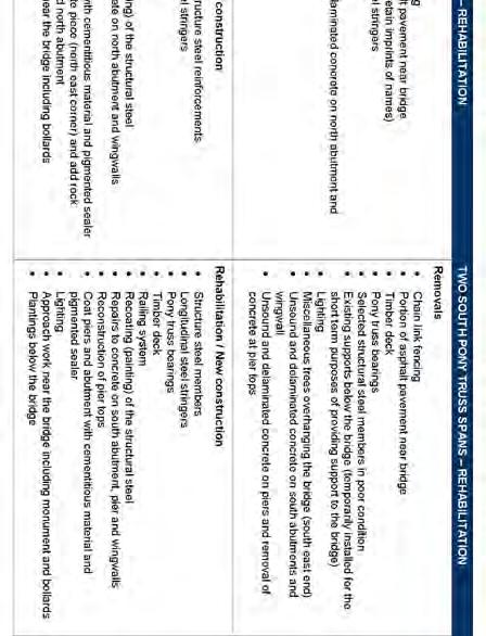
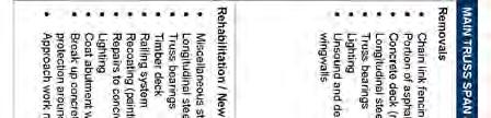
34 4.4 Technical Environment Visual and Ultrasonic Inspection AECOM undertook a detailed visual field investigation of the Meadowlily Bridge from April 21 to 23, General non-destructive testing (ultrasonic) and extraction of steel samples for tensile tests were completed by Domson Engineering and Inspection Inc. Concrete cores were extracted from the substructure and tested by EXP. (formerly Trow Associates Inc.). Domson s summary report and the core logs and photographs are included as part of the Meadowlily Bridge Restoration and Cultural Heritage Evaluation Study in Appendix B. The following summarize the findings of visual inspections and testing. Substructure Both the north and south abutment walls were observed to be in fair to poor condition showing signs of scaling and cracking. The wing walls were also in fair condition with scaling, cracking and some spalling on the south wall. The north pier is in fair condition with medium to severe scaling, some honeycombing (poor ventilation causing a defect in the concrete), spalling (concrete fragments detaching from the host piece) and horizontal cracking. The pedestal extensions on the south side of the pier, which supports the pony truss, are in poor condition with disintegration, spalling and cracking along the cold joint pour lines. Vegetation is growing from the cracks and a significant amount of concrete rubble is found on the bearing seat. The south pier is in a similar condition to the north pier but also contained efflorescence staining (small calcium deposits that form as water runs through cracks in concrete) on the top cap. Steel portal frames were constructed in 2008 to support floor beam connections to reduce the potential for beam failure on the two pony truss spans. The frames were in good condition. Superstructure The structural steel was generally in fair condition and entirely covered in surface corrosion. All members appear to have minor section loss but ultrasonic indicated that member thicknesses did not vary significantly. There were many observations of minor localized defects in the steel components including pitting, deformation (some due to impact), minor rust jacking on connector plates and perforations of various sizes. In general, the pony trusses are in fair to poor condition. The majority of the chord and diagonal members that make up the pony trusses are in fair condition with light to medium section loss to the structural steel. Observations of localized steel defects were evident including pitting, minor deformation, and small to medium sized perforations. Most floor beams and many connection plates were in poor condition with extensive section loss and large perforations through the members. Rpt- Final Screening Report Docx 14
35 The concrete deck of the main truss is original to the bridge and in fair to poor condition. The top of the deck shows signs of scaling, spalling, cracking and has several holes punched through the deck. The deck underside has exposed eroded reinforcing, honeycombing, delamination, spalling, cracking and efflorescence staining. The timber deck of the pony truss was constructed in 1990 and appears to be in fair condition Structural Analysis Based on the visual inspection and non-destructive testing (NDT) results, a detailed structural analysis was carried out on the footbridge. The maximum load carrying capacity of the various structural components of the footbridge were evaluated and compared with the maximum loading conditions. Many of the primary bridge elements (trusses) and secondary elements (beams) were found to have sufficient load capacity. However, diagonal members and floor beams were tested to have insufficient capacity for pedestrian loading. Appendix B contains the complete structural analysis report Hydraulic Analysis The existing hydraulic conditions at the footbridge were determined through a review of background material and a detailed survey provided by the City. Original flood elevations were calculated using the existing HEC-RAS model developed by UTRCA. However the model was updated to better reflect existing conditions. The results indicate an increase in flood elevations in the vicinity of the footbridge for the 2-year through 250-year storm event design flood elevations. The low point for the footbridge is located at the south edge of the footbridge deck where overtopping of 0.19 m occurs for the modeled 250-year flood elevation. Flood elevations for the 2-year through 100-year storm events are conveyed under the footbridge. Rpt- Final Screening Report Docx 15
36 The footbridge meets both the soffit minimum clearance requirement for a local road and the minimum freeboard requirement. The footbridge also meets the minimum navigable soffit clearance as outlined in the Canadian Highway Bridge Design Code. The design of the rehabilitation works will retain the existing piers and deck configuration providing no opportunity for raising the structure or increasing the hydraulic opening. No new impacts are expected to be associated with the rehabilitation of the footbridge. The hydraulic analysis is found in Appendix F. 4.5 Policy and Approvals The following section outlines the policies and approvals relevant to this study The Planning Act The Planning Act (2005) sets out the ground rules for land use planning in Ontario and describes how land uses may be controlled, and who may control them. Pursuant to the Planning Act, the Province of Ontario is the primary planning authority in Ontario. The Planning Act enables the Province to delegate some of its planning authority to the upper-tier municipalities (e.g. counties and regional/district municipalities, as well as planning boards) while retaining control through the approval process. Municipalities must conform to approved policies of the Provincial government and its agencies. Provincial ministries, municipal councils, planners and other stakeholders implement the Act when such actions include: Preparing Official Plans and planning policies that guide future development considering provincial interests, such as protecting and managing natural resources; and Regulating and controlling land uses through zoning by-laws and minor variances Provincial Policy Statement The Provincial Policy Statement (PPS) is the complimentary policy document to the Planning Act. Issued under the authority of Section 3 of the Planning Act, the PPS provides direction on matters of provincial interest related to land use planning and development and promotes the provincial policy-led planning system that recognizes and addresses the complex interrelationship among environmental, economic and social factors in land use planning (MMAH, 2005). The Planning Act requires that the PPS be reviewed periodically to ensure its policies are still effective. The new PPS (2005) took effect on March 1, 2005 and provides for enhanced protection of the environment by identifying the significance of the natural heritage system and water resources, including natural hazards and water quality, air quality and energy use. The policies provide for intensification and Brownfield development to ensure the maximum use of sewer, water and energy systems, roads and transit. General principles are established in the PPS that are further elaborated on in a detailed set of policies that generally address the following matters: Building Strong Communities; Wise Use and Management of Resources; and Protecting Public Health and Safety. Rpt- Final Screening Report Docx 16
37 In addition, the following policies are relevant to this study: Section 1.5 addresses Public Spaces, Parks and Open Space noting that Healthy, active communities should be promoted by planning public streets, spaces and facilities to be safe, meet the needs of pedestrians and facilitate pedestrian and non-motorized movement, including but not limited to walking and cycling. Section 2.6 addresses Cultural Heritage and Archaeology noting that significant built heritage resources and significant cultural heritage landscapes shall be conserved ; Official Plan The Official Plan (OP) for the City of London contains policies approved by Council to provide direction for the allocation of land use, provision of services and facilities and policies to control the use of land, having regard for social, economic and environmental matters. This report has regard for and complies with the following relevant policies. Schedule A Land Use of the OP designates the area where the footbridge is located as Open Space. Within the open space designation parks and recreational facilities are permitted. See Figure 4.1. Schedule B-1 Natural Heritage Features identifies the area north of the footbridge as including unevaluated wetland, significant corridor, unevaluated vegetation patch and Big Picture Meta- cores and Meta-Corridors. South of the footbridge the natural heritage features include the Meadowlily ESA, maximum hazard line and Big Picture Meta-Cores and Meta corridors. See Figure 4.2. It is the intent of these designations to keep natural feature corridors intact. This project will not impact the corridor. Typically projects within close proximity to ESAs require the completion of an Environmental Impact Study (EIS). However through discussions with City of London Parks Planning, it was determined that an EIS in not warranted for the recommended work. The following OP policies are relevant to this study: Heritage Resource Policies Section Alteration, Removal or Demolition Where heritage buildings are designated under the Ontario Heritage Act, no alteration, removal or demolition shall be undertaken which would adversely affect the reason(s) for designation except in accordance with the Ontario Heritage Act. The footbridge has been designated under Part IV of the Ontario Heritage Act therefore consultation is required with the London Advisory Committee on Heritage (LACH) to determine the acceptability of any proposed alterations. Rpt- Final Screening Report Docx 17

38 MEADOWLILY FOOTBRIDGE MEADOWLILY ROAD COMMISSIONERS ROAD HIGHBURY AVENUE ¹ ,000 1, Metres MEADOWLILY FOOTBRIDGE REHABILITATION MUNICIPAL CLASS EA FIGURE 4.1: Schedule A - Land Use PN: DATE: NOVEMBER 2012 SCALE: AS SHOWN

39 MEADOWLILY FOOTBRIDGE MEADOWLILY ROAD ¹ , Metres MEADOWLILY FOOTBRIDGE REHABILITATION MUNICIPAL CLASS EA FIGURE 4.2: Schedule B1 - Natural Heritage Features PN: DATE: NOVEMBER 2012 SCALE: AS SHOWN
Second Line West Pedestrian/Cyclist Crossing of Highway 401 Class EA. Second Line West Pedestrian/Cyclist Crossing of Highway 401 Class EA
 1 1 Purpose of Public Information Centre #2 To provide interested and/or potentially affected stakeholders with an opportunity to participate in the planning and decision-making process for this Municipal
Victoria Bridge Municipal Class EA Civic Works Committee
 Municipal Class EA John Pucchio, P. Eng., Project Manager June 19 2018 Introduction Existing Conditions Municipal Class EA Proposed Bridge Proposed Road Reconstruction Proposed Improvements Construction
The purpose of tonight s PIC is to:
 The purpose of tonight s PIC is to: Provide an overview of the work completed to date and a summary of the Class EA process being followed; Provide a summary of public input received so far, including
Commissioners Road West Realignment Environmental Assessment
 City of London Commissioners Road West Realignment Environmental Assessment Public Information Centre No. 1 March 30, 2017 Welcome to the Public Information Centre This first Public Information Centre
City of Toronto. Emery Village Transportation Master Plan
 City of Toronto Emery Village Transportation Master Plan May 2009 Emery Village Transportation Master Plan Toronto, ON May 2009 Consulting Inc. 100 York Blvd., Suite 300 Richmond Hill, ON L4B 1J8 Tel:
GLEN ROAD PEDESTRIAN BRIDGE ENVIRONMENTAL ASSESSMENT STUDY PUBLIC INFORMATION CENTRE #2 OCTOBER 24, 2017
 GLEN ROAD PEDESTRIAN BRIDGE ENVIRONMENTAL ASSESSMENT STUDY PUBLIC INFORMATION CENTRE #2 OCTOBER 24, 2017 Glen Road Pedestrian Bridge Class Environmental Assessment 1 WELCOME! Welcome to the second Public
West London Dyke, April 1947 Flood. Forks of the Thames, July 2000 Flood. Source: UTRCA
 This Public Information Centre is the 1 st of 2. Its purpose is to inform the public and to receive input with regards to the West London Dyke Master Repair Plan. The following panels describe the history,
WELCOME TO THE PUBLIC INFORMATION CENTRE. Please Sign In
 WELCOME TO THE PUBLIC INFORMATION CENTRE Replacement of Oxtongue Lake Narrows Bridge & Oxtongue River Bridge, Highway 60 (G.W.P. 93-89-00 & G.W.P. 5550-04-00) Class Environmental Assessment (Group B) Please
CITY OF VAUGHAN EXTRACT FROM COUNCIL MEETING MINUTES OF NOVEMBER 15, 2016
 Item 11, Report No. 38, of the Committee of the Whole, which was adopted without amendment by the Council of the City of Vaughan on November 15, 2016. Regional Councillor Di Biase declared an interest
Bridge Type Assessment and Evaluation
 16M-01410-01 (3216026) Glen Road Pedestrian Bridge EA Study Bridge Type Assessment and Evaluation Factor Group/Criteria Alternative 1: Steel girder with two inclined steel legs Alternative 2: Steel girder
WELCOME TO PUBLIC INFORMATION CENTRE #2. Please Sign In
 WELCOME TO PUBLIC INFORMATION CENTRE #2 Replacement of Oxtongue Lake Narrows Bridge & Oxtongue River Bridge, Highway 60 (G.W.P. 93-89-00 & G.W.P. 5550-04-00) Class Environmental Assessment (Group B) Please
The MSII reports for the bridge indicate that the Annual Average Daily Traffic at the bridge is 100. The road can be considered a low volume road.
 Page 1 1 INTRODUCTION 1.1 Background The Bronk Road Bridge is located on Bronk Road about 0.2 km north of Thrasher Road and spans Parks Creek, a tributary of the Moira River. Bronk Road is the road allowance
Vaughan Metropolitan Centre (VMC) Black Creek Renewal CLASS ENVIRONMENTAL ASSESSMENT
 Black Creek Renewal CLASS ENVIRONMENTAL ASSESSMENT") PUBLIC INFORMATION CENTRE Vaughan Metropolitan Centre (VMC) Black Creek Renewal Wednesday, May 10, 2017 6:00 p.m. to 8:00 p.m. Add photo Project Management, Environmental Assessment, Stormwater Management
PUBLIC INFORMATION CENTRE Vaughan Metropolitan Centre (VMC) Black Creek Renewal Wednesday, May 10, 2017 6:00 p.m. to 8:00 p.m. Add photo Project Management, Environmental Assessment, Stormwater Management
Public Information Centre
 Public Information Centre Sunnidale Road Highway 400 Transmission i Watermain Crossing January 31, 2012 Sir Robert Barrie Room, 2 nd Floor, City Hall 4:00 pm to 7:00 pm As part of the Environmental Assessment
Municipal Class EA Study Public Information Centre No. 1 December 13, :00 pm 7:00 pm. Please sign in so we can keep you updated on this study
 Reconstruction of Regional Road 45 (Creek Road) Between Regional Road 27 (River Road) and Regional Road 63 (Canborough Road) in the Township of Wainfleet Municipal Class EA Study Public Information Centre
Blackfriars Bridge Municipal Class Environmental Assessment. Public Information Centre #1 November 19 th, 2014
 Blackfriars Bridge Municipal Class Environmental Assessment Public Information Centre #1 November 19 th, 2014 Why are you here tonight? To determine the future requirements of the river crossing at Blackfriars
Rapid Transit Implementation Working Group September 14, 2017
 Rapid Transit Implementation Working Group September 14, 2017 BACKGROUND Council approved the Rapid Transit Master Plan and Updated Business Case on July 25, 2017. Approval of the RTMP confirmed the BRT
WELCOME TO OPEN HOUSE TWO November 28, 2018
 Langstaff Road Weston Road to Highway 7 Class Environmental Assessment Study WELCOME TO OPEN HOUSE TWO November 28, 2018 Please sign in and join our mailing list Study Overview York Region is conducting
GEOMETRIC IMPROVEMENTS AND WATERMAIN LOOPING MUNICIPAL CLASS ENVIRONMENTAL ASSESSMENT
 GEOMETRIC IMPROVEMENTS AND WATERMAIN LOOPING MUNICIPAL CLASS ENVIRONMENTAL ASSESSMENT Veterans Way (previously Powerline Road) and Klondike Park Road Wasaga Beach Welcome Please sign in Take a comment
Commissioners Road West Realignment Environmental Assessment
 City of London Commissioners Road West Realignment Environmental Assessment Public Information Centre No. 2 November 29, 2017 Welcome to the Public Information Centre This 2 nd Public Information Centre
Lower Don River West Remedial Flood Protection Project TABLE OF CONTENTS. Page. Executive Summary
 TABLE OF CONTENTS Page Executive Summary 1.0 INTRODUCTION...1-1 1.1 Purpose of the Undertaking...1-1 1.2 Study Area Description...1-1 1.3 Description of the Undertaking...1-1 1.4 Rationale for the Undertaking...1-2
Public Information Centre #1
 and Highway 401 Interchange Improvements WELCOME Public Information Centre #1 Veterans Memorial Parkway Extension and Highway 401 Interchange Improvements Study May 23, 2012 4 p.m. to 7 p.m. Brief Overview
Bostwick Road. Municipal Class Environmental Assessment. October 13, City of London. Bostwick Road Municipal Class Environmental Assessment
 Bostwick Road Municipal Class Environmental Assessment October 13, 2016 Welcome! Welcome to the first Public Information Centre for the Bostwick Road Municipal Class Environmental Assessment. Representatives
Services Department B September 10, 2007
 Report To: Development Services Committee Item: Date of Report: DS-07-246 September 5, 2007 From: Commissioner, Development File: Date of Meeting: Services Department B7200-0001 September 10, 2007 Subject:
Recreational Pathway Crossing of Richmond Street Municipal Class Environmental Assessment. Public Information Centre #2 April 22, 2015
 Recreational Pathway Crossing of Richmond Street Municipal Class Environmental Assessment Public Information Centre #2 April 22, 2015 1. Study Process PHASE 1 PHASE 2 PHASE 3 PHASE 1 : Problem/Opportunity
~!VAUGHAN NOV Z November 21, Mr. Denis Kelly, Regional Clerk The Regional Municipality of York Yonge Street Newmarket, ON L3Y 6Z1
 ~!VAUGHAN NOV Z 5 2016 November 21, 2016 Mr. Denis Kelly, Regional Clerk The Regional Municipality of York 17250 Yonge Street Newmarket, ON L3Y 6Z1 Dear Mr. Kelly: RE: NEW KIRBY GO STATION IN BLOCK 27
Purpose of Open House #3
 Public Meeting #3 May 9, 2009 MVVA Team Purpose of Open House #3 The main purpose of this Open House is to present and seek input on the: Evaluation of transportation and infrastructure design alternatives
Public Meeting #3 May 9, 2009 MVVA Team
 Public Meeting #3 May 9, 2009 MVVA Team Welcome to the third Public Meeting for the Lower Don Lands Municipal Class Environmental Assessment (EA) Infrastructure Master Plan and Keating Channel Precinct
Bostwick Road. Municipal Class Environmental Assessment. Public Information Centre #2 June 14, City of London
 Bostwick Road Municipal Class Environmental Assessment Public Information Centre #2 June 14, 2017 Welcome! Welcome to the 2 nd Public Information Centre for the. Representatives from the and the consulting
Commissioners Road West. Municipal Class Environmental Assessment. City of London
 Commissioners Road West Municipal Class Environmental Assessment Commissioners Road West Realignment from Springbank Drive/Byron Baseline Road to Cranbrook Road ENVIRONMENTAL STUDY REPORT B000615 Commissioners
Emery Village Road 2A Municipal Class Environmental Assessment Study
 PW12.11 STAFF REPORT ACTION REQUIRED Emery Village Road 2A Municipal Class Environmental Assessment Study Date: March 30, 2016 To: From: Wards: Reference Number: Public Works and Infrastructure Committee
Victoria Street Pedestrian Bridge
 Township of Centre Wellington Victoria Street Pedestrian Bridge Class Environmental Assessment County of Wellington & Township of Centre Wellington Badley Bridge Replacement/Rehabilitation (County of Wellington),
THE CORPORATION OF THE CITY OF WINDSOR Office of the City Solicitor Planning Department
 THE CORPORATION OF THE CITY OF WINDSOR Office of the City Solicitor Planning Department REPORT TO THE CITY OF WINDSOR PLANNING ADVISORY COMMITTEE DATE OF REPORT: August 19, 2010 SUBJECT: Official Plan
CHAIR AND MEMBERS CIVIC WORKS COMMITTEE MEETING ON JUNE 19, 2018
 TO: FROM: SUBJECT: CHAIR AND MEMBERS CIVIC WORKS COMMITTEE MEETING ON JUNE 19, 2018 KELLY SCHERR, P. ENG., MBA, FEC MANAGING DIRECTOR, ENVIRONMENTAL & ENGINEERING SERVICES AND CITY ENGINEER VICTORIA BRIDGE
Heritage Road Improvements from Steeles Avenue to Rivermont Road
 The Corporation of the City of Brampton Heritage Road Improvements from Steeles Avenue to Rivermont Road Class Environmental Assessment Study (Schedule C) September 19, 2013 The Corporation of the City
John M. Fleming Managing Director, Planning and City Planner. Old East Village Dundas Street Corridor Secondary Plan Draft Terms of Reference
 Report to Planning and Environment Committee To: From: Subject: Chair and Members Planning & Environment Committee John M. Fleming Managing Director, Planning and City Planner Old East Village Dundas Street
9 CITY OF VAUGHAN OFFICIAL PLAN AMENDMENT NO BOCA EAST INVESTMENTS LIMITED
 9 CITY OF VAUGHAN OFFICIAL PLAN AMENDMENT NO. 631 - BOCA EAST INVESTMENTS LIMITED The Planning and Economic Development Committee recommends the adoption of the recommendations contained in the following
APPENDIX L3. Table of Contents. SWP EA Information Sheets
 E N V I R O N M E N T A L A S S E S S M E N T APPENDIX L3 SWP EA Information Sheets Table of Contents EA Info Sheet 1... L3-1 EA Info Sheet 2... L3-3 EA Info Sheet 3... L3-5 EA Info Sheet 4... L3-7 SCARBOROUGH
Public Information Centre. Welcome
 Transportation Improvements from the Beaver Creek Bridge to the Entrance of Santa s Village District of Muskoka Municipal Class Environmental Assessment Welcome Please sign in Take a comment sheet Staff
THE CITY OF VAUGHAN BY-LAW BY-LAW NUMBER
 THE CITY OF VAUGHAN BY-LAW BY-LAW NUMBER 123-2013 A By-law to designate the whole of the City of Vaughan as a Site Plan Control Area, and to adopt site development guidelines and rules of procedure for
II PREVIOUS REPORTS PERTINENT TO THIS MATTER II
 ~ ~~ ~~~ ~ ~~ ~ ~~~~ ~ ~~ ~~ ~~~~ ~ Agenda Item # Page # TO: FROM: -..-.-I- 3UBJCL I CHAIR AND MEMBERS ENVIRONMENT AND TRANSPORTATION COMMITTEE MEETING ON OCTOBER 17,2005 DAVID A. LECKIE, P. ENG DIRECTOR
Western Road/Wharncliffe Road North Widening from Platts Lane to Oxford Street. Municipal Class Environmental Assessment Public Information Centre #1
 Western Road/Wharncliffe Road North Widening from Platts Lane to Oxford Street Municipal Class Environmental Assessment Public Information Centre #1 June 11, 2014 Welcome Welcome to the first Public Information
Long Branch Neighbourhood Character Guidelines Final Report
 STAFF REPORT ACTION REQUIRED Long Branch Neighbourhood Character Guidelines Final Report Date: October 26, 2017 To: From: Wards: Reference Number: Etobicoke York Community Council Director, Community Planning,
TERRESTRIAL NATURAL HERITAGE SYSTEM STRATEGY APPENDIX F: MODEL POLICIES FOR THE IMPLEMENTATION OF THE TARGET TERRESTRIAL NATURAL HERITAGE SYSTEM
 TERRESTRIAL NATURAL HERITAGE SYSTEM STRATEGY APPENDIX F: MODEL POLICIES FOR THE IMPLEMENTATION OF THE TARGET TERRESTRIAL NATURAL HERITAGE SYSTEM C H A P T E R 1 M O D E L P O L I C I E S F O R I M P L
Slope Stability Management Framework
 Slope Stability Management Framework For the assessment, evaluation, prioritization and mitigation of slope stability concerns. 2013/06/19 The Slope Stability Management Framework provides guidance to
VILLAGE OF BOLTON HERITAGE CONSERVATION DISTRICT PLAN
 Page 1 1. INTRODUCTION AND BACKGROUND 1.1 THE PROJECT VILLAGE OF BOLTON HERITAGE CONSERVATION DISTRICT PLAN TERMS OF REFERENCE The Town of Caledon (Town) is a large, predominantly rural municipality with
Study Process / Planning Policy Issues
 Memorandum Date: March 13 th, 2009 To: From: Reference: Subject: Murray Thompson, URS Canada Tyler Drygas, Senior Environmental Planner, URS Canada Detroit River International Crossing Study Response to
TRANSPORTATION COMMITTEE
 TRANSPORTATION COMMITTEE CITY OF OTTAWA Ministry of Transportation Detailed Design Assignment G.W.P.# 4058-01-00 Highway 417 (Ottawa Queensway) Widening & Rehabilitation from Maitland Avenue to Island
Report to: Development Services Committee Report Date: September 11, 2017
 ~RKHAM Report to: Development Services Committee Report Date: September 11, 2017 SUBJECT: PREPARED BY: Conceptual Master Plan for the Future Urban Area - Community Structure Plan and Key Policy Direction
Wellington County Badley Bridge Replacement/Rehabilitation Environmental Assessment (EA)Study Welcome
Study Welcome") Wellington County Badley Bridge Replacement/Rehabilitation Environmental Assessment (EA)Study Welcome Welcome to the first Public Information Centre (PIC) meeting. Please record your attendance and obtain
Wellington County Badley Bridge Replacement/Rehabilitation Environmental Assessment (EA)Study Welcome Welcome to the first Public Information Centre (PIC) meeting. Please record your attendance and obtain
Mavis Road Class Environmental Assessment
 Mavis Road Class Environmental Assessment Public Information Centre #2 Wednesday November 9, 2016 6:00 to 8:00 p.m. Please sign in and complete a comment sheet Review the displays on your own or join in
Whitchurch Bridge Approach Road
 Approach Road Addendum to Report for Highway Widening On behalf of The Company Project Ref: 36466/ Rev: 0 Date: March 2017 Office Address: Caversham Bridge House, Waterman Place, Reading, Berkshire RG1
GLEN ROAD PEDESTRIAN BRIDGE ENVIRONMENTAL ASSESSMENT STUDY PUBLIC INFORMATION CENTRE #1 SEPTEMBER 28, 2016
 GLEN ROAD PEDESTRIAN BRIDGE ENVIRONMENTAL ASSESSMENT STUDY PUBLIC INFORMATION CENTRE #1 SEPTEMBER 28, 2016 Glen Road Pedestrian Bridge Class Environmental Assessment WELCOME! Welcome to the first Public
COUNCIL ATTACHMENT 2 HIGHWAY 7 CORRIDOR AND VAUGHAN NORTH-SOUTH LINK
 COUNCIL ATTACHMENT 2 HIGHWAY 7 CORRIDOR AND VAUGHAN NORTH-SOUTH LINK Welcome! The purpose today is to: Present the Study Background; Describe Alignment Alternatives Analyzed; Present the Evaluation of
Ashbridges Bay Erosion and Sediment Control Project
 Ashbridges Bay Erosion and Sediment Control Project Project Brief Overview Toronto and Region Conservation Authority, in partnership with the City of Toronto, intends to carry out remedial erosion control
Macintosh HD:CURRENT WORK-(JRW):4026 Northumberland Trent River Crossings:4026_Mem- Pannu_Report(jm)Oct2510.docx
:4026 Northumberland Trent River Crossings:4026_Mem- Pannu_Report(jm)Oct2510.docx") MEMORANDUM To: Mobushar Pannu, County of Northumberland From: Nick McDonald Date: October 27, 2010 Re: First Draft of Report (Trent River Crossing) Our File No: 4026 Attached to this memorandum is a first
MEMORANDUM To: Mobushar Pannu, County of Northumberland From: Nick McDonald Date: October 27, 2010 Re: First Draft of Report (Trent River Crossing) Our File No: 4026 Attached to this memorandum is a first
CALL TO ARTISTS Expression of Interest (EOI)
") City of Mississauga Culture Division 201 City Centre Drive, Ste 202 MISSISSAUGA ON L5B 2T4 mississauga.ca CALL TO ARTISTS Expression of Interest (EOI) Public Artwork for Mavis Road Bridge Submission Deadline:
City of Mississauga Culture Division 201 City Centre Drive, Ste 202 MISSISSAUGA ON L5B 2T4 mississauga.ca CALL TO ARTISTS Expression of Interest (EOI) Public Artwork for Mavis Road Bridge Submission Deadline:
TORONTO TRANSIT COMMISSION AND THE REGIONAL MUNICIPALITY OF YORK
 TORONTO TRANSIT COMMISSION AND THE REGIONAL MUNICIPALITY OF YORK NOTICE OF PREPARATION OF AN ADDENDUM REPORT TO THE HIGHWAY 7 CORRIDOR AND VAUGHAN NORTH-SOUTH LINK ENVIRONMENTAL ASSESSMENT & RESPONSE TO
Committee of the Whole (Public Hearing) Report
 Report") Item:1 Committee of the Whole (Public Hearing) Report DATE: Tuesday, June 05, 2018 WARD: 2 TITLE: OFFICIAL PLAN AMENDMENT FILE OP.17.016 ZONING BY-LAW AMENDMENT FILE Z.17.046 IMPORTANNE MARKETING INC.
Item:1 Committee of the Whole (Public Hearing) Report DATE: Tuesday, June 05, 2018 WARD: 2 TITLE: OFFICIAL PLAN AMENDMENT FILE OP.17.016 ZONING BY-LAW AMENDMENT FILE Z.17.046 IMPORTANNE MARKETING INC.
Better Cycling. The City will update the cycling master plan (London ON Bikes) based on the approved BRT network.
 based on the approved BRT network.") Better Cycling Dedicated bike facilities will be constructed along BRT corridors where space is available. Nearby bike routes will also be upgraded to ensure a complete network is available for cyclists.
Better Cycling Dedicated bike facilities will be constructed along BRT corridors where space is available. Nearby bike routes will also be upgraded to ensure a complete network is available for cyclists.
Recreational Pathway Crossing of Richmond Street Municipal Class Environmental Assessment Environmental Study Report
 Recreational Pathway Crossing of Richmond Street Municipal Class Environmental Assessment Environmental Study Report Prepared by: AECOM 410 250 York Street, Citi Plaza 519 673 0510 tel London, ON, Canada
Ashbridges Bay TTC Maintenance and Storage Facility
 Ashbridges Bay TTC Maintenance and Storage Facility September 8, 2010 Presented to Government Review Team 1 Presentation Overview Overview of the Project Status of Transit Project Assessment Process Potential
TOWN OF WHITBY REPORT RECOMMENDATION REPORT
 TOWN OF WHITBY REPORT RECOMMENDATION REPORT REPORT TO: Council REPORT NO: PL 95-09 DATE OF MEETING: October 13, 2009 PREPARED BY: Planning/Public Works Joint Report FILE NO(S): N/A LOCATION: N/A REPORT
implementation r expression in landscape
 6 ubc okanagan implementation campus plan r expression in landscape 68 6 implementation campus plan sections The Campus Plan supports the academic mission, values and commitments of the University by providing
Elevated Water Storage Facility and Pumping Station Municipal Class EA for Pressure District 7: PIC # 1 Summary
 Memorandum DATE: March 14, 2018 TO: FROM: CC: OUR REF.#: SUBJECT: Winston Wang, M.A.Sc., P.Eng Project Manager, City of Hamilton Jennifer Whittard, B.E.S., PMP Shelley Kuan, Jessica Mollo WM16-0435 Elevated
Public Information Centre No. 1 King-Vaughan Road Bridge Replacement Municipal Class Environmental Assessment City of Vaughan
 Public Information Centre No. 1 King-Vaughan Road Bridge Replacement Municipal Class Environmental Assessment City of Vaughan Date: April 7, 2016 Location: Al Palladini Community Centre, Meeting Room #1
c. DTAH Toronto Complete Streets Guidelines
 c. DTAH Toronto Complete Streets Guidelines 164 166 C.1 Project Delivery Process 168 C.5 This section provides a summary of the overarching process for delivering street projects in Toronto. The conclusion
ONE RIVER MASTER PLAN ENVIRONMENTAL ASSESSMENT
 ONE RIVER MASTER PLAN ENVIRONMENTAL ASSESSMENT TERMS OF REFERENCE 1. ONE RIVER PROJECT OVERVIEW At its meeting on May 17, 2016, Council considered a staff report regarding the One River Master Plan Environmental
THAT the attached Terms of Reference for the Thornhill Centre Street Study be approved.
 COMMITTEE OF THE WHOLE AUGUST 18, 2003 THORNHILL CENTRE STREET STUDY PLANNING FILE: 15.92 Recommendation The Commissioner of Planning recommends: THAT the attached Terms of Reference for the Thornhill
Alternative Routes. St. Vital to La Verendrye Station - Southern Loop Transmission Corridor. 20 different segments 4 segments common to all routes
 Alternative Routes St. Vital to La Verendrye Station - Southern Loop Transmission Corridor In a fixed right-of-way St. Vital to Letellier Station 20 different segments 4 segments common to all routes Goal
SPECIAL COMMITTEE OF THE WHOLE DECEMBER 9, 2002 BLOCK 57/58 WEST BLOCK PLAN BLOCK PLAN FILE BL.57/58W.99 HUNTINGTON BUSINESS PARK LAND OWNERS
 SPECIAL COMMITTEE OF THE WHOLE DECEMBER 9, 2002 BLOCK 57/58 WEST BLOCK PLAN BLOCK PLAN FILE BL.57/58W.99 HUNTINGTON BUSINESS PARK LAND OWNERS Recommendation The Commissioner of Planning recommends: THAT
WILLIAM STREET STORM SEWER OUTFALL. PUBLIC INFORMATION CENTRE March 23, 2017
 WILLIAM STREET STORM SEWER OUTFALL Municipal Class Environmental Assessment PUBLIC INFORMATION CENTRE March 23, 2017 ACCESSIBILITY Under the Accessibility Standards 2015 for Customer Service Regulation
8 Oak Street - Official Plan and Zoning By-law Amendment Application - Preliminary Report
 STAFF REPORT ACTION REQUIRED 8 Oak Street - Official Plan and Zoning By-law Amendment Application - Preliminary Report Date: March 17, 2014 To: From: Wards: Reference Number: Planning and Growth Management
Introduction. Public Information Package. Project website. Overview. Class Environmental Assessment Process
 1 Introduction Public Information Package Baseline Road Extension between Lambs Road and Bennett Road, Bowmanville Schedule B Municipal Class Environmental Assessment November 6, 2017 Overview The purpose
2 STATUTORY PUBLIC MEETING AND INFORMATION REPORT FOR PUBLIC MEETING ON AMENDMENT NO. 62 TO THE YORK REGION OFFICIAL PLAN
 2 STATUTORY PUBLIC MEETING AND INFORMATION REPORT FOR PUBLIC MEETING ON AMENDMENT NO. 62 TO THE YORK REGION OFFICIAL PLAN Pursuant to Section 17(15) of the Planning Act, as amended, the Regional Planning
TABLE OF CONTENTS Page
 TABLE OF CONTENTS Table of Contents Page 1 INTRODUCTION... 1-1 1.1 Introduction and Background... 1-1 1.1.1 Current Class Environmental Assessment Study... 1-1 1.2 Study Area (Section 1)... 1-3 1.3 Ontario
Portage Parkway Environmental Assessment Public Information Centre No. 1
 City of Vaughan Portage Parkway Environmental Assessment Public Information Centre No. 1 November 25, 2015 Welcome to the Public Information Centre This first Public Information Centre (PIC) introduces
Rapid Transit Implementation Working Group
 Rapid Transit Implementation Working Group October 12, 2017 1 Agenda 1. Consultation Update 2. Technical Work Update 3. LTC Rapid Transit Integration 4. Next Steps 2 Consultation Update 3 Consultation
I. DESCRIPTION OF PROPOSED ACTION... 1 A. General Description... 1 B. Historical Resume and Project Status... 2 C. Cost Estimates...
 PROJECT COMMITMENTS SUMMARY... S-1 1. Type of Action... S-1 2. Description of Action... S-1 3. Summary of Purpose and Need... S-1 4. Alternatives Considered... S-2 5. NCDOT Alternatives Carried Forward...
SECTION 7A: WHAKARONGO RESIDENTIAL AREA
 SECTION 7A: WHAKARONGO RESIDENTIAL AREA CONTENTS 7A.1 Introduction 1 7A.2 Resource Management Issues 1 7A.3 Objectives and Policies 1 7A.4 Methods 4 7A.5 Residential Zone 4 7A.5.1 Rules: Controlled Activities
TOWN OF AURORA HERITAGE IMPACT ASSESSMENTS AND CONSERVATION PLANS GUIDE
 PLANNING AND DEVELOPMENT SERVICES Development Planning Division Heritage Planning Section Phone: 905-727-3123 ext. 4226 Fax: 905-726-4736 Email: planning@aurora.ca Town of Aurora 100 John West Way, Box
F2. Draft Archaeological and Cultural Heritage Net Effects Analysis & Comparative Evaluation Report
 F2. Draft Archaeological and Cultural Heritage Net Effects Analysis & Comparative Evaluation Report Clean Harbors Canada Inc. Lambton Landfill Expansion Environmental Assessment Draft Archaeological and
St. Clair Avenue West Area Transportation Master Plan
 1 (Between Keele Street and Old Weston Road) Public Information Centre 1 December 2, 2015 2 Welcome Welcome to the first Public Information Centre for the St. Clair Avenue West Area. The panels will present
DRAFT MAP AMENDMENT FLU 04-4
 DRAFT MAP AMENDMENT FLU 04-4 SW 24 TH AVENUE ROADWAY CORRIDOR The University of Florida participates with the Metropolitan Transportation Planning Organization (MTPO) in its responsibilities for the continuing,
Don Mills Crossing Study and Celestica Lands Development Application Community Meeting, Open House, and Breakout Discussions
 Consultation Summary Don Mills Crossing Study and Celestica Lands Development Application Community Meeting, Open House, and Breakout Discussions This report is not intended to provide a verbatim transcript
ONTARIO MUNICIPAL BOARD
 PL 120483 ONTARIO MUNICIPAL BOARD Applicant/Appellant: 2124123 Ontario Limited Subject: OPA, Rezoning and Draft Plan of Subdivision Municipal Address: 3940 Highway 7 East Municipality: City of Markham
volume 11 environmental assessment section 2 environmental impact assessment Part 7 ha 218/08
 DESIGN MANUAL FOR ROADS AND BRIDGES volume 11 environmental assessment section 2 environmental impact assessment Part 7 ha 218/08 glossary of terms Used in DMRB Volume 11, Sections 1 and 2 SUMMARY This
Welcome. Mill Creek Ravine Pedestrian Bridges Rehabilitation. Public Information Session #1. Thursday, October 27, :00 8:00 p.m.
 Welcome Mill Creek Ravine Pedestrian Bridges Rehabilitation Public Information Session #1 Thursday, October 27, 2016 5:00 8:00 p.m. Tonight you can: Learn about the rehabilitation of 5 pedestrian bridges
1.0 Purpose of a Secondary Plan for the Masonville Transit Village
 Report to Planning and Environment Committee To: Chair and Members Planning & Environment Committee From: John M. Fleming Managing Director, Planning and City Planner Subject: Masonville Transit Village
The Commissioner of Engineering and Public Works, the Director of Public Works and the Director of Development / Transportation Engineering recommend:
 COMMITTEE OF THE WHOLE JUNE 16, 2008 WATER FOUNTAINS AND AERATION DEVICES IN STORM WATER MANAGEMENT FACILITIES Recommendations The Commissioner of Engineering and Public Works, the Director of Public Works
Services Department F May 28, 2007
 Report To: Development Services Committee Item: Date of Report: From: DS-07-144 May 23, 2007 Commissioner, Development File: Date of Meeting: Services Department F-7000-0013 May 28, 2007 Subject: Gibb
Ontario Municipal Board Commission des affaires municipales de l'ontario
 PL150128 Ontario Municipal Board Commission des affaires municipales de l'ontario PROCEEDING COMMENCED UNDER subsection 34(11) of the Planning Act, R.S.O. 1990, c. P. 13, as amended Applicant and Appellant:
CITY OF VAUGHAN EXTRACT FROM COUNCIL MEETING MINUTES OF MAY 6, 2014
 CITY OF VAUGHAN EXTRACT FROM COUNCIL MEETING MINUTES OF MAY 6, 2014 Item 35, Report No. 18, of the Committee of the Whole, which was adopted, as amended, by the Council of the City of Vaughan on May 6,
Red Hill Valley Project More Than A Road October 16, 2006
 Red Hill Valley Project Presented By: More Than A Road October 16, 2006 September, 2007 Gerry Davis, C.M.A., Senior Director, Capital Planning and Implementation Division Public Works Department City of
1.0 INTRODUCTION AND BACKGROUND
 1.0 INTRODUCTION AND BACKGROUND 1.1 INTRODUCTION / BACKGROUND The Regional Municipality of York (hereafter referred to as York Region ) has completed a Municipal Class Environmental Assessment (Class EA)
12 AMENDMENT NO. 149, TOWN OF MARKHAM HIGHWAY 404 NORTH SECONDARY PLAN
 12 AMENDMENT NO. 149, TOWN OF MARKHAM HIGHWAY 404 NORTH SECONDARY PLAN The Planning and Economic Development Committee recommends the adoption of the recommendation contained in the following report August
PennDOT. single spann lanes and 3- mayy need to be to accommodate. any bridge. addition to III. Date: CRP 07/27/2015 CRP.
 (10/27/14) PennDOT Section 106 Field Assessments and Finding Combined Early tification/finding? Yes Concurrence required or requested: Yes MPMS: 51507 ER# (if consultation with PHMC required) ): County:
ONLINE PUBLIC INFORMATION CENTRE
 ONLINE PUBLIC INFORMATION CENTRE County Road 17 Bridge Replacements Detail Design and Environmental Assessment GWP 4203-15-00 The Ministry of Transportation Ontario (MTO) has retained CH2M Hill and Dillon
Highway 427 Industrial Secondary Plan Area 47 Schedule C Class Environmental Assessment For Arterial Roadways
 Welcome to Pubic Information Centre #1 Highway 427 Industrial Secondary Plan Area 47 Schedule C Class Environmental Assessment For Arterial Roadways Welcome to Open House # 1 Tonight, we invite you to.
East Panorama Ridge Concept Plan Amendment
 Page 1 of 7 L003 : East Panorama Ridge Concept Plan Amendment Corporate NO: L003 Report COUNCIL DATE: March 4, 2002 REGULAR COUNCIL LAND USE TO: Mayor & Council DATE: February 27, 2002 FROM: General Manager,