Wellington County Badley Bridge Replacement/Rehabilitation Environmental Assessment (EA)Study Welcome
|
|
|
- Agatha Owen
- 5 years ago
- Views:
Transcription


1 Wellington County Badley Bridge Replacement/Rehabilitation Environmental Assessment (EA)Study Welcome Welcome to the first Public Information Centre (PIC) meeting. Please record your attendance and obtain a comment sheet at the registration desk. Several background reports are available at the Resource Table. Should you have any questions regarding the presentation materials, background reports or any other aspect of the study, please speak to the County or Consultant study team members in attendance. We encourage your input/feedback on the material being presented on the display boards. Please deposit completed comment sheets in the comment box or mail/ fax/ e- mail to the address at the bottom of the form within the next two weeks. There is an opportunity at any time during the EA process for interested persons to provide written input. Any comments received will be collected under the Environmental Assessment Act and, with the exception of personal information, will become part of the public record.. 1

2 Introduction Wellington County has initiated an Environmental Assessment (EA) to move forward with the rehabilitation or replacement of the Badley Bridge. This Study will complete all phases of the Municipal Class EA by establishing the need and justification for the project, considering all alternatives and proactively involving the public in defining a Recommended Plan for improvements. This Study is being completed as a Schedule C undertaking, based on the range of anticipated effects. A draft Study Design describing the study process has been available for agency and public comments. It is available at the Resource Table and has been posted on the County website for public review and comments.. 2

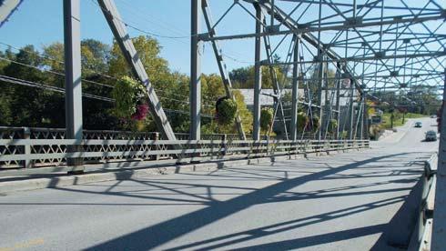
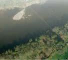
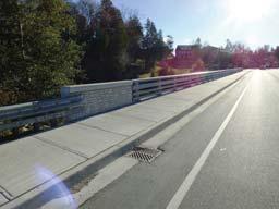
3 Study Area Aerial Photo Mosaic W Mill Street 3

4 . Municipal Class Environmental Assessment (EA) Process This project is being undertaken as a Schedule C Class EA in accordance with the Municipal Class Environmental Assessment, 2011, a copy of which is available at the Resource Table. The EA study will culminate in the delivery of an Environmental Study Report (ESR), which is a detailed compilation of all data and reports produced for the project. If after viewing the exhibits and otherwise participating in this project, and at the conclusion of the process, you still have concerns, you have the right to request the Minister of the Environment to reclassify the project through a Part II Order (or bump-up ) to an Individual Environmental Assessment. Community Café Event for stakeholders Draft Study Design Study process is here (PIC #1) 4


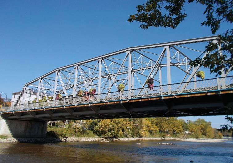
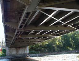
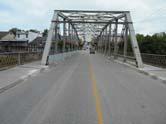
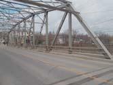
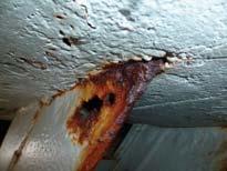
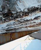
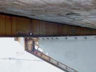
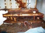
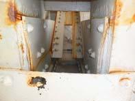
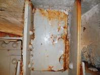
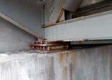
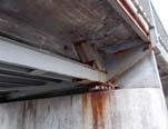
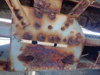
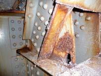
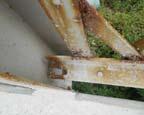
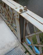
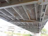
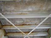
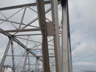
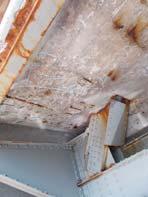
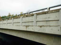
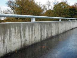
5 Need and Justification Structural Condition The Badley Bridge was constructed in 1953, and is nearing the end of its service life. The bridge currently operates with a load limit of 22 tonnes. Past rehabilitation took place in 1975, 1995, 1997, 2010 and The 2015 repairs were not fully completed based on the magnitude of capital costs to complete. Emergency repairs were completed in May and June In 2015, MMM Group completed a structural evaluation that revealed several members are theoretically overstressed and many members are deteriorating. The conclusion of MMM s investigations are summarized in a structural Condition/ Structural Needs Analysis Technical Memorandum on the resource table. The structural analysis has concluded that major elements are in an advanced state of deterioration. The cost of maintaining the current bridge under a rehabilitation approach may meet or exceed the cost of replacement options and therefore the EA Study has been initiated to define the most appropriate bridge management strategy to carry forward. 5


6


7


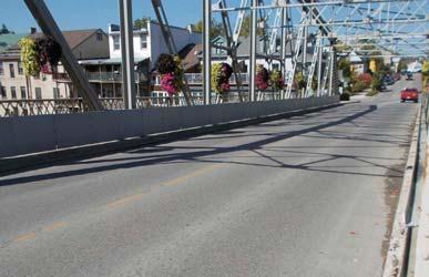
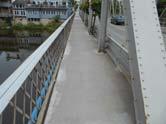
8 Vehicle and Pedestrian Traffic The Woolwich Street bridge in Salem (18 tonnes load restriction). The David Street and WR7 intersection. The David Street bridge Existing vehicles/day Primary access route to downtown Elora. Existing Metcalfe Street/ Carlton Place Parking Existing pedestrian activity. Badley Bridge carries an average of: 9,500 vehicles/day Over 500 pedestrians/day The Metcalfe Street/ Carlton Place Lot provides parking for 33 vehicles on the south side of the river crossing 8


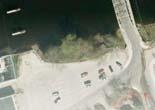
9 Marine Traffic A survey of marine uses on the Grand River (between the Drimmie Dam and the Bissell Dam) was conducted on Thursday, August 20, During this time the following marine uses were observed: No boats were observed using the river; Two boats were docked at the Elora Raft Rides dock; and Two people were observed fishing in the river east of the structure. Fishing activity in the river Elora Raft Rides dock. View easterly from the bridge. 9

10 Transportation Existing Conditions Travel Survey Origin/Destination Survey (Wednesday August 26, 2015) Findings from the survey included: Approximately 9,500 trips daily The Badley Bridge is used primarily for local travel purposes by Elora residents 35% of the travel across the bridge was for work related travel, and 33% was attracted by shopping and restaurants Approximately 68% of all vehicles on the bridge had a single occupant Pedestrian Survey (Saturday September 5, 2015) Of the individuals surveyed: Approximately 30% originated from the Greater Toronto Area. 80% had arrived by automobile 70% were able to obtain on-street parking 1 out of every 7 people parked on the south side of the river Parking within approximately a 10 minute walk was, on average, considered reasonable Pedestrian Survey Parking Map 10


11 Environmental Inventories Natural Environment The Badley Bridge crosses the Grand River through a calm reach. The river is considered cold water fish habitat in this area. The underside of the bridge offers nesting opportunities for birds although no nests were observed. Piers are located outside the normal high water level. Shorelines indicate the stony, rocky nature of the substrate. Limestone bedrock is close to the surface and bottom currents apparently scour the streambed. Although there is little overhanging vegetation the shorelines are quite natural and undisturbed for the most part. 11


12 Environmental Inventories Natural Environment Some areas of the shoreline are quite favourable for fish. Water quality appears somewhat degraded. Even developed shoreline has some natural features adjacent to the watercourse. Downstream piers offer fish habitat opportunities. A weir is just downstream of the piers, which restricts fish access to the reach to only upstream. An upstream dam obstructs fish passage. No Species at Risk have been identified in the Study Area. 12

, now uncommon in the Township o Important in supporting the historic character of Elora o A landmark structure in Elora Draft CHER is available on the")
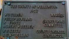
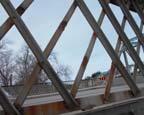
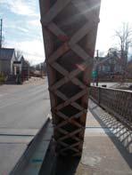
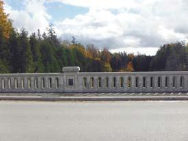
13 Environmental Inventories Cultural Heritage Bridge Description Constructed in 1953 Example of a nine-panel rivet constructed Parker camelback truss bridge Constructed by contractor A.H. MacLellan and the Hamilton Bridge Company, with County Engineer W.H. Keith Current Heritage Status of Bridge Not listed on Municipal Heritage Register Not designated under Ontario Heritage Act Cultural Heritage Evaluation (CHER Draft) Metcalfe/Badley Bridge identified through CHER and previous studies as: o Representative of a style/type (Parker Camelback Through Truss), now uncommon in the Township o Important in supporting the historic character of Elora o A landmark structure in Elora Draft CHER is available on the Resource Table. 13

14 Environmental Inventories Cultural Heritage Broader Heritage Context Several listed/designated buildings adjacent or in the near vicinity of the bridge study area Red pins are properties listed on the Municipal Register, blue pins are designated under the Ontario Heritage Act. 14

15 Environmental Inventories Cultural Heritage Cultural Heritage Next Steps A Heritage Impact Assessment (HIA) report is required, based on: o The location of the bridge over the Grand River, a Canadian Heritage River watershed o The presence of adjacent designated/listed properties o The evaluation of the bridge as having some cultural heritage value or interest The HIA will assess all alternatives carried forward and their impacts to the cultural heritage value of the bridge/context and adjacent properties The HIA will identify conservation measures/mitigation measures to avoid/reduce adverse impacts 15
16 Environmental Inventories Geotechnical The existing geotechnical conditions in the vicinity of the crossing have been summarized in a Geotechnical Desktop Report and are available at the Resource Table Surficial geology has been influenced by extensive glacial activity of the late Wisconsin period The site is located in the Physiographic Region known as the Guelph Drumlin Field The Grand River flows in an old glacial meltwater spillway The existing bridge is founded on dolostone bedrock The rock profile of the crossing of the Grand River is illustrated on the following exhibit 17

17 Environmental Inventories Utilities 18


 and residential land uses that make use of the river crossing.")

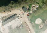
18 Land Use The land use of the Study Area is predominantly commercial and residential properties. The majority of the downtown core is occupied by multiple local businesses with residences above the storefronts. The Township of Centre Wellington s Official Plan designates the study area lands as being a Central Business District. The Central Business District located both north and south of the bridge is described as being for general commercial purposes. The objective is to ensure the downtown core of Elora is the central location for commerce and social functions. South of the bridge there are both commercial (LCBO, Shoe Villa, Gorge Country Kitchen etc.) and residential land uses that make use of the river crossing. The lands within 6 miles of the Grand River are defined in the Haldimand Treaty of 1784 describing the rights of the Six Nations. The Land Use Planning Report is available at the Resource Table. Gorge Country Kitchen on Wellington Road 7 Property at 5 East Mill Street Commercial/residential properties on W Mill Street LCBO located at 23 Metcalfe Street Metcalfe Street/ Carlton Place Parking Lot located south of the river crossing Commercial and residential property on West Mill Street 19
 Vertical Clearance for 100 year flood = 1.07 m± Freeboard for 100 year flood = 2.")
19 Technical Studies Hydraulics MTO Standards: Design Flood Return Period is the 100 year flood (for arterial road and bridge span greater than 6 m). Vertical Clearance > 1.0 m Freeboard > 1.0 m Existing Bridge Waterway meets the MTO Standards: Passes the 100 year flood (586 m 3 /s) Vertical Clearance for 100 year flood = 1.07 m± Freeboard for 100 year flood = 2.13 m± The Hydraulic Technical Memorandum is available at the Resource Table. 20

20 Technical Studies Hydraulics Bridge Span Alternatives Examined for Effect on Flood Levels, assuming that the soffit of the new structure is at the same elevation as the existing. Bridge Alternative Single Span 48 m Single Span 60 m Two Span 36m-36m Three Spans 24m-24m-24m Effect on Regional Storm Water Level +0.13m -0.02m +0.01m +0.03m The effects on the 100 year return period flood, and higher probability floods, are less than 0.04m in all cases. 21
21 Evaluation Methodology Assessment of Alternative Planning Solutions The evaluation of alternatives is completed in a two-step process. The initial step is to consider alternative planning solutions. For this study, the alternative planning solutions included: The Do Nothing Alternative Close Badley Bridge Rehabilitation of Badley Bridge Replacement of Badley Bridge The Do Nothing alternative or closing the bridge is not recommended to be carried forward for this project based on the age and function of the existing structure. The closure of the existing bridge has not been recommended to be carried forward based on the strategic and historical link to the downtown of Elora. This link provides access to businesses and provides emergency service access across the Grand River. The rehabilitation alternative has been considered and is known to add further life cycle costs to repair the bridge to extend its current useful life before completing a future replacement. It would also result in greater community impacts by planning two construction projects. However, based on the potential cultural heritage value a number of rehabilitation strategies are available including conservation and mitigation approaches. To provide due regard for heritage concerns the rehabilitation (repair alternative) will be carried forward for further detailed evaluation including input from a Heritage Impact Assessment. The construction of a new replacement structure will continue to support the ongoing land use development in the Study Area. Should no comments be received that object to this recommendation then the EA will continue through the evaluation of preliminary design alternatives for the structure. The review of Alternative Planning Solutions is described in a technical memorandum available on the Resource Table. 22
22 Rehabilitation Alternatives This planning approach reflects a strategy to maintain the existing bridge by continued investment in repairs, rehabilitation or select replacement of bridge components. This approach would consider the heritage values of the bridge and the cost of increasing operating and maintenance investment as the bridge nears the end of its service life. This approach would postpone the future replacement of this bridge. This strategy would consider both conservation options or strategies as well as mitigation approaches. These may include: Conservation strategies: Restoration of missing or deteriorated elements where physical or documentary evidence (i.e. photographs or drawings) can be used for their design; Retention of existing bridge with no major modification undertaken; Retention of existing bridge with sympathetic modification; Retention of existing bridge with sympathetically designed new structure in proximity; Retention of existing bridge no longer in use for vehicular purposes but adapted for pedestrian walkways, cycle paths, scenic viewing, etc; Relocation of bridge to appropriate new site for continued use or adaptive re-use; and Retention of bridge as heritage monument for viewing purposes only. Mitigation Strategies: Salvage of elements/members of bridge for incorporation into new structure or for future conservation work or displays; and Full recording and documentation of structure if it is to be demolished. 23
23 Detailed Qualitative Evaluation Methodology MATS Process The evaluation approach to compare preliminary design alternatives, described as the Multi Attribute Trade-off System (MATS), is based on the Weighted Additive Method which focuses on the differences between the alternatives, addressing the complexity of the base data collected, and providing a traceable decision-making process. In addition, the method allows quick sensitivity tests to be performed because of the matrix configuration of the assessment and the use of numerical scores to measure the impact of the alternatives. The evaluation methodology report is available at the resource table. The initial task in the evaluation is to develop evaluation criteria from which alternatives will be assessed. This process includes the identification of global groups of factors followed by the selection of a number of local sub-factors under the global groups. A preliminary list of global factors and their corresponding sub-factors proposed for the evaluation of alternatives is shown on the following exhibit. The public is asked to comment on issues that should be considered for the evaluation of alternatives. For this study an independent test will be undertaken which places greater or less emphasis on a global factor and redistributing the weight to the other factors using the average values of the TAC. This sensitivity testing will show the tradeoffs between alternatives. 24
24 Preliminary Evaluation Criteria The following preliminary evaluation criteria (factor groups and sub-factors) are presented for comment for the assessment of the alternatives: TRANSPORTATION Pedestrian out-of-way travel Bicycle out-of-way travel Pedestrian Safety Bicycle Safety Accommodates commercial vehicles NATURAL ENVIRONMENT Regionally Significant Vegetation Wildlife Habitat Species at Risk (SAR) Habitat impacted Loss of fish habitat SOCIO-CULTURAL ENVIRONMENT No. of existing residential properties with sound level increases Visual intrusion Accommodates recreational activities (i.e. walking, cycling) Area of Archaeological Potential Impacted HERITAGE/ARCHAEOLOGY Bridge heritage Downtown heritage Cultural Heritage Landscape LAND USE AND PLANNING Loss of land ECONOMIC Business impacts Customer walking distance to parking COST Roadway Capital Cost (including bridge replacement or rehabilitation) Roadway Maintenance Costs BRIDGE HYDRAULICS Upstream Water level increase 25
25 Evaluation Methodology Alternative Combinations The alternatives will involve a combination of bridge alternatives, barrier alternatives, transportation/traffic staging and hydraulic performance. An example of how these will combine to create an alternative is illustrated below: Bridge Transportation/ Traffic Staging Hydraulics Barrier Bridge Cross Section and Sidewalk Technically Preferred Alternative Bridge Alternatives (structural types or rehabilitation program) Transportation/ Traffic Staging Alternatives Upstream water level changes for Regional storms Barrier Alternatives Bridge cross section and sidewalk alternatives Combination of: - Bridge Alternatives - Transportation /Traffic Staging Alternatives - Hydraulic Alternatives - Barrier and Roadway Cross Section 26
26
27
28
29
30
31
32

33 THREE SPAN RIGID FRAME Bridge Alternatives Carried Forward
34 Bridge Alternatives Carried Forward TWO SPAN PRESTRESSED CONCRETE GIRDER
35 SINGLE SPAN STEEL BOX GIRDER Bridge Alternatives Carried Forward
36 THREE SPAN STEEL TRUSS Bridge Alternatives Carried Forward


37 Bridge Alternatives Carried Forward FOUR SPAN PRESTRESSED CONCRETE BOX GIRDER


38
39
40
41
42
43
44

45 Detour Options Vehicular Traffic (Cars and Trucks) Designation of David Street as the Primary Detour Route Would limit out-of-way travel to less than 1.5 km The need for temporary traffic signals at Wellington Road 7 is anticipated The David Street and Geddes Street intersection would be unable to accommodate turning truck traffic Use of Woolwich Street (through Salem) Increases out-of-way travel, up to 4 km 18 tonnes load restriction on the Woolwich Street bridge would limit truck access Use of St David Street Bridge (through Fergus) Out-of-way travel increased to 5.7 km from Guelph but 11 kms for local trips Use of South River Road would result in increased safety concerns due to sight distance constraints and without provisions for pedestrians Designation of Multiple Route Alternatives (by direction) Would limit traffic impact on any one corridor Limits the out-of-way travel by direction 46

46 Detour Options - Pedestrian and Cyclists Over 500 pedestrians cross the bridge daily. On September 5, 2015, 1 out of every 7 pedestrians surveyed had crossed the Badley Bridge after parking on the south side of the river. To accommodate these pedestrians and cyclists the following detour options are being considered: Construction of a temporary pedestrian bridge Increased cost with no lasting benefit Use of the Bissel Park Bridge Out-of-way travel (1.6 km) reasonable for cyclists but not pedestrians Without accommodating pedestrians, concerns regarding access to parking and businesses south of the river are not addressed Prior Construction of the Victoria Street Pedestrian Bridge Timing of the planned pedestrian structure remains uncertain 47
47 Schedule Following this meeting we will: Finalize the Recommended Plans Public Information Centre No. 2 winter/ spring 2016 File the Environmental Study Report (ESR) fall 2016 How can you remain involved in the Study? Request that your name/ be added to the mailing list Provide a completed comment sheet Contact the County s representative or the consultant at any time Any of our representatives that are present can assist you with the above activities. Thank you for your participation in tonight s meeting. Your input into this study is valuable and appreciated. Please provide your completed comment form on or before December 18, All information is collected in accordance with the Freedom of Information and Privacy Act. 48
Victoria Street Pedestrian Bridge
 Township of Centre Wellington Victoria Street Pedestrian Bridge Class Environmental Assessment County of Wellington & Township of Centre Wellington Badley Bridge Replacement/Rehabilitation (County of Wellington),
Station Street/Haig Road Extension Environmental Assessment (EA)Study. Welcome
Study. Welcome") Station Street/Haig Road Extension Environmental Assessment (EA)Study Welcome Welcome to this Public Information Centre (PIC) meeting. Please record your attendance and obtain a comment sheet at the registration
Station Street/Haig Road Extension Environmental Assessment (EA)Study Welcome Welcome to this Public Information Centre (PIC) meeting. Please record your attendance and obtain a comment sheet at the registration
HERITAGE IMPACT ASSESSMENT SALEM BRIDGE, COUNTY SITE No. B IRVINE CREEK (LOTS 15 & 16, CONCESSION 11 GEOGRAPHIC TOWNSHIP OF NICHOL)
") HERITAGE IMPACT ASSESSMENT SALEM BRIDGE, COUNTY SITE No. B018050 IRVINE CREEK (LOTS 15 & 16, CONCESSION 11 GEOGRAPHIC TOWNSHIP OF NICHOL) WOOLWICH STREET WEST (WR 18) SALEM, TOWNSHIP OF CENTRE WELLINGTON
HERITAGE IMPACT ASSESSMENT SALEM BRIDGE, COUNTY SITE No. B018050 IRVINE CREEK (LOTS 15 & 16, CONCESSION 11 GEOGRAPHIC TOWNSHIP OF NICHOL) WOOLWICH STREET WEST (WR 18) SALEM, TOWNSHIP OF CENTRE WELLINGTON
GLEN ROAD PEDESTRIAN BRIDGE ENVIRONMENTAL ASSESSMENT STUDY PUBLIC INFORMATION CENTRE #2 OCTOBER 24, 2017
 GLEN ROAD PEDESTRIAN BRIDGE ENVIRONMENTAL ASSESSMENT STUDY PUBLIC INFORMATION CENTRE #2 OCTOBER 24, 2017 Glen Road Pedestrian Bridge Class Environmental Assessment 1 WELCOME! Welcome to the second Public
Victoria Bridge Municipal Class EA Civic Works Committee
 Municipal Class EA John Pucchio, P. Eng., Project Manager June 19 2018 Introduction Existing Conditions Municipal Class EA Proposed Bridge Proposed Road Reconstruction Proposed Improvements Construction
Municipal Class EA Study Public Information Centre No. 1 December 13, :00 pm 7:00 pm. Please sign in so we can keep you updated on this study
 Reconstruction of Regional Road 45 (Creek Road) Between Regional Road 27 (River Road) and Regional Road 63 (Canborough Road) in the Township of Wainfleet Municipal Class EA Study Public Information Centre
WELCOME TO PUBLIC INFORMATION CENTRE #2. Please Sign In
 WELCOME TO PUBLIC INFORMATION CENTRE #2 Replacement of Oxtongue Lake Narrows Bridge & Oxtongue River Bridge, Highway 60 (G.W.P. 93-89-00 & G.W.P. 5550-04-00) Class Environmental Assessment (Group B) Please
Commissioners Road West Realignment Environmental Assessment
 City of London Commissioners Road West Realignment Environmental Assessment Public Information Centre No. 1 March 30, 2017 Welcome to the Public Information Centre This first Public Information Centre
WELCOME TO OPEN HOUSE TWO November 28, 2018
 Langstaff Road Weston Road to Highway 7 Class Environmental Assessment Study WELCOME TO OPEN HOUSE TWO November 28, 2018 Please sign in and join our mailing list Study Overview York Region is conducting
Blackfriars Bridge Municipal Class Environmental Assessment. Public Information Centre #1 November 19 th, 2014
 Blackfriars Bridge Municipal Class Environmental Assessment Public Information Centre #1 November 19 th, 2014 Why are you here tonight? To determine the future requirements of the river crossing at Blackfriars
WELCOME TO THE PUBLIC INFORMATION CENTRE. Please Sign In
 WELCOME TO THE PUBLIC INFORMATION CENTRE Replacement of Oxtongue Lake Narrows Bridge & Oxtongue River Bridge, Highway 60 (G.W.P. 93-89-00 & G.W.P. 5550-04-00) Class Environmental Assessment (Group B) Please
Public Information Centre No. 1 King-Vaughan Road Bridge Replacement Municipal Class Environmental Assessment City of Vaughan
 Public Information Centre No. 1 King-Vaughan Road Bridge Replacement Municipal Class Environmental Assessment City of Vaughan Date: April 7, 2016 Location: Al Palladini Community Centre, Meeting Room #1
The purpose of tonight s PIC is to:
 The purpose of tonight s PIC is to: Provide an overview of the work completed to date and a summary of the Class EA process being followed; Provide a summary of public input received so far, including
The MSII reports for the bridge indicate that the Annual Average Daily Traffic at the bridge is 100. The road can be considered a low volume road.
 Page 1 1 INTRODUCTION 1.1 Background The Bronk Road Bridge is located on Bronk Road about 0.2 km north of Thrasher Road and spans Parks Creek, a tributary of the Moira River. Bronk Road is the road allowance
Second Line West Pedestrian/Cyclist Crossing of Highway 401 Class EA. Second Line West Pedestrian/Cyclist Crossing of Highway 401 Class EA
 1 1 Purpose of Public Information Centre #2 To provide interested and/or potentially affected stakeholders with an opportunity to participate in the planning and decision-making process for this Municipal
Bostwick Road. Municipal Class Environmental Assessment. Public Information Centre #2 June 14, City of London
 Bostwick Road Municipal Class Environmental Assessment Public Information Centre #2 June 14, 2017 Welcome! Welcome to the 2 nd Public Information Centre for the. Representatives from the and the consulting
Bostwick Road. Municipal Class Environmental Assessment. October 13, City of London. Bostwick Road Municipal Class Environmental Assessment
 Bostwick Road Municipal Class Environmental Assessment October 13, 2016 Welcome! Welcome to the first Public Information Centre for the Bostwick Road Municipal Class Environmental Assessment. Representatives
Lower Don River West Remedial Flood Protection Project TABLE OF CONTENTS. Page. Executive Summary
 TABLE OF CONTENTS Page Executive Summary 1.0 INTRODUCTION...1-1 1.1 Purpose of the Undertaking...1-1 1.2 Study Area Description...1-1 1.3 Description of the Undertaking...1-1 1.4 Rationale for the Undertaking...1-2
City of Toronto. Emery Village Transportation Master Plan
 City of Toronto Emery Village Transportation Master Plan May 2009 Emery Village Transportation Master Plan Toronto, ON May 2009 Consulting Inc. 100 York Blvd., Suite 300 Richmond Hill, ON L4B 1J8 Tel:
Bridge Type Assessment and Evaluation
 16M-01410-01 (3216026) Glen Road Pedestrian Bridge EA Study Bridge Type Assessment and Evaluation Factor Group/Criteria Alternative 1: Steel girder with two inclined steel legs Alternative 2: Steel girder
GLEN ROAD PEDESTRIAN BRIDGE ENVIRONMENTAL ASSESSMENT STUDY PUBLIC INFORMATION CENTRE #1 SEPTEMBER 28, 2016
 GLEN ROAD PEDESTRIAN BRIDGE ENVIRONMENTAL ASSESSMENT STUDY PUBLIC INFORMATION CENTRE #1 SEPTEMBER 28, 2016 Glen Road Pedestrian Bridge Class Environmental Assessment WELCOME! Welcome to the first Public
St. Clair Avenue West Area Transportation Master Plan
 1 (Between Keele Street and Old Weston Road) Public Information Centre 1 December 2, 2015 2 Welcome Welcome to the first Public Information Centre for the St. Clair Avenue West Area. The panels will present
Purpose of Open House #3
 Public Meeting #3 May 9, 2009 MVVA Team Purpose of Open House #3 The main purpose of this Open House is to present and seek input on the: Evaluation of transportation and infrastructure design alternatives
Public Meeting #3 May 9, 2009 MVVA Team
 Public Meeting #3 May 9, 2009 MVVA Team Welcome to the third Public Meeting for the Lower Don Lands Municipal Class Environmental Assessment (EA) Infrastructure Master Plan and Keating Channel Precinct
City Of Owen Sound. 10th Street Bridge Evaluation - Schedule 'C' Environmental Study Report. Version 2 (Phase 3) GMBP File: June 26, 2018
 GMBP File: June 26, 2018") Prepared By: City Of Owen Sound 10th Street Bridge Evaluation - Schedule 'C' Environmental Study Report Version 2 (Phase 3) GMBP File: 215235 June 26, 2018 GUELPH OWEN SOUND LISTOWEL KITCHENER LONDON HAMILTON
Prepared By: City Of Owen Sound 10th Street Bridge Evaluation - Schedule 'C' Environmental Study Report Version 2 (Phase 3) GMBP File: 215235 June 26, 2018 GUELPH OWEN SOUND LISTOWEL KITCHENER LONDON HAMILTON
Commissioners Road West Realignment Environmental Assessment
 City of London Commissioners Road West Realignment Environmental Assessment Public Information Centre No. 2 November 29, 2017 Welcome to the Public Information Centre This 2 nd Public Information Centre
Public Information Centre. Welcome
 Transportation Improvements from the Beaver Creek Bridge to the Entrance of Santa s Village District of Muskoka Municipal Class Environmental Assessment Welcome Please sign in Take a comment sheet Staff
Portage Parkway Environmental Assessment Public Information Centre No. 1
 City of Vaughan Portage Parkway Environmental Assessment Public Information Centre No. 1 November 25, 2015 Welcome to the Public Information Centre This first Public Information Centre (PIC) introduces
City of Cornwall Municipal Class Environmental Assessment. Proposed Improvement and Extension of Lemay Street
 Welcome City of Cornwall Municipal Class Environmental Assessment Proposed Improvement and Extension of Lemay Street Redevelopment and Design of the Municipal Works Yard Public Information Centre #1 Thursday,
Municipal Heritage Bridges Cultural, Heritage and Archaeological Resources Assessment Checklist Revised April 11, 2014
 Municipal Heritage Bridges Cultural, Heritage and Archaeological Assessment Checklist Revised April 11, 2014 This checklist was prepared in March 2013 by the Municipal Engineers Association to assist with
ONLINE PUBLIC INFORMATION CENTRE
 ONLINE PUBLIC INFORMATION CENTRE County Road 17 Bridge Replacements Detail Design and Environmental Assessment GWP 4203-15-00 The Ministry of Transportation Ontario (MTO) has retained CH2M Hill and Dillon
Better Cycling. The City will update the cycling master plan (London ON Bikes) based on the approved BRT network.
 based on the approved BRT network.") Better Cycling Dedicated bike facilities will be constructed along BRT corridors where space is available. Nearby bike routes will also be upgraded to ensure a complete network is available for cyclists.
Better Cycling Dedicated bike facilities will be constructed along BRT corridors where space is available. Nearby bike routes will also be upgraded to ensure a complete network is available for cyclists.
APPENDIX K WINDSOR OFFICIAL PLAN
 CEAA ENVIRONMENTAL ENVIRONMENTAL IMPACT ASSESSMENT AMBASSADOR BRIDGE ENHANCEMENT PROJECT Replacement Span and Plaza Expansion APPENDIX K WINDSOR OFFICIAL PLAN Avalon Consulting Professionals of Ontario,
Vaughan Metropolitan Centre (VMC) Black Creek Renewal CLASS ENVIRONMENTAL ASSESSMENT
 Black Creek Renewal CLASS ENVIRONMENTAL ASSESSMENT") PUBLIC INFORMATION CENTRE Vaughan Metropolitan Centre (VMC) Black Creek Renewal Wednesday, May 10, 2017 6:00 p.m. to 8:00 p.m. Add photo Project Management, Environmental Assessment, Stormwater Management
PUBLIC INFORMATION CENTRE Vaughan Metropolitan Centre (VMC) Black Creek Renewal Wednesday, May 10, 2017 6:00 p.m. to 8:00 p.m. Add photo Project Management, Environmental Assessment, Stormwater Management
Mavis Road Class Environmental Assessment
 Mavis Road Class Environmental Assessment Public Information Centre #2 Wednesday November 9, 2016 6:00 to 8:00 p.m. Please sign in and complete a comment sheet Review the displays on your own or join in
Highway 427 Industrial Secondary Plan Area 47 Schedule C Class Environmental Assessment For Arterial Roadways
 Welcome to Pubic Information Centre #1 Highway 427 Industrial Secondary Plan Area 47 Schedule C Class Environmental Assessment For Arterial Roadways Welcome to Open House # 1 Tonight, we invite you to.
Rapid Transit Implementation Working Group September 14, 2017
 Rapid Transit Implementation Working Group September 14, 2017 BACKGROUND Council approved the Rapid Transit Master Plan and Updated Business Case on July 25, 2017. Approval of the RTMP confirmed the BRT
HAZARD MITIGATION GOALS AND OBJECTIVES
 SEWRPC Community Assistance Planning Report No. 282, 2nd Edition CITY OF MILWAUKEE ALL HAZARDS MITIGATION PLAN UPDATE Chapter IV HAZARD MITIGATION GOALS AND OBJECTIVES [NOTE: Throughout this plan update
Public Information Centre #1
 and Highway 401 Interchange Improvements WELCOME Public Information Centre #1 Veterans Memorial Parkway Extension and Highway 401 Interchange Improvements Study May 23, 2012 4 p.m. to 7 p.m. Brief Overview
GEOMETRIC IMPROVEMENTS AND WATERMAIN LOOPING MUNICIPAL CLASS ENVIRONMENTAL ASSESSMENT
 GEOMETRIC IMPROVEMENTS AND WATERMAIN LOOPING MUNICIPAL CLASS ENVIRONMENTAL ASSESSMENT Veterans Way (previously Powerline Road) and Klondike Park Road Wasaga Beach Welcome Please sign in Take a comment
Public Information Centre
 Public Information Centre Sunnidale Road Highway 400 Transmission i Watermain Crossing January 31, 2012 Sir Robert Barrie Room, 2 nd Floor, City Hall 4:00 pm to 7:00 pm As part of the Environmental Assessment
CONSULTING SERVICES FOR THE WHITEBELT VISIONING EXERCISE ADDENDUM TO THE GTA WEST LAND USE STUDY WORK PROGRAM
 CONSULTING SERVICES FOR THE WHITEBELT VISIONING EXERCISE ADDENDUM TO THE GTA WEST LAND USE STUDY 1. Introduction WORK PROGRAM The Town of Caledon is a large, local municipality located in the Greater Toronto
WILLAMETTE FALLS LEGACY PROJECT
 OPPORTUNITIES & CONSTRAINTS There are here three falls on a line of rocks extending across the river, which forms the bed of the upper channel. The water is precipitated through deep abrazed gorges, and
CHAIR AND MEMBERS CIVIC WORKS COMMITTEE MEETING ON JUNE 19, 2018
 TO: FROM: SUBJECT: CHAIR AND MEMBERS CIVIC WORKS COMMITTEE MEETING ON JUNE 19, 2018 KELLY SCHERR, P. ENG., MBA, FEC MANAGING DIRECTOR, ENVIRONMENTAL & ENGINEERING SERVICES AND CITY ENGINEER VICTORIA BRIDGE
Master Environmental Servicing Plan & Secondary Plan
 1 East Side Lands Stage 2 Master Environmental Servicing Plan & Secondary Plan Public Consultation Centre #4 March 20, 2018 Welcome! Today s Agenda Please sign in at the registration table. 6:00 pm 6:30
Scarborough Waterfront Project
 Scarborough Waterfront Project Public Information Centre #1 Environmental Assessment Terms of Reference September 10, 2014 Agenda Open House Presentation 7:00 to 7:30 pm Presentation 7:30 to 8:15 pm History
Adelaide Street / Canadian Pacific Railway (CPR) Grade Separation Class Environmental Assessment. Public Information Centre 3
 Grade Separation Class Environmental Assessment. Public Information Centre 3") 1 Adelaide Street / Canadian Pacific Railway (CPR) Grade Separation Study Process and Purpose of PIC 3 2 Study Commencement February 2016 Phase 1: Problem and Opportunity Identify problems and opportunities
1 Adelaide Street / Canadian Pacific Railway (CPR) Grade Separation Study Process and Purpose of PIC 3 2 Study Commencement February 2016 Phase 1: Problem and Opportunity Identify problems and opportunities
Emery Village Road 2A Municipal Class Environmental Assessment Study
 PW12.11 STAFF REPORT ACTION REQUIRED Emery Village Road 2A Municipal Class Environmental Assessment Study Date: March 30, 2016 To: From: Wards: Reference Number: Public Works and Infrastructure Committee
TRANSPORTATION COMMITTEE
 TRANSPORTATION COMMITTEE CITY OF OTTAWA Ministry of Transportation Detailed Design Assignment G.W.P.# 4058-01-00 Highway 417 (Ottawa Queensway) Widening & Rehabilitation from Maitland Avenue to Island
You Don't Know What You've Got 'til it's Gone. Creative Cities Summit 2012 Victoria, British Columbia Kate Hagerman Cultural Heritage Specialist
 You Don't Know What You've Got 'til it's Gone Creative Cities Summit 2012 Victoria, British Columbia Kate Hagerman Cultural Heritage Specialist Presentation Outline Waterloo Region Research Based Conservation
Adelaide Street / Canadian Pacific Railway (CPR) Grade Separation. Public Information Centre #1
 Grade Separation. Public Information Centre #1") 1 Adelaide Street / Canadian Pacific Railway (CPR) Why Are We Here? 2 The purpose of Public Information Centre (PIC) #1 is to: Introduce the study Provide the study background and context Identify the
1 Adelaide Street / Canadian Pacific Railway (CPR) Why Are We Here? 2 The purpose of Public Information Centre (PIC) #1 is to: Introduce the study Provide the study background and context Identify the
London s Bus Rapid Transit System
 London s Bus Rapid Transit System HERITAGE WORKSHOP November 7, 2017 1 Agenda 1. Introductions 2. Overview of Transit Project Assessment Process 3. Archaeology and Heritage Approval Process 4. Role of
Strachan Ave. Overpass Community Design Update. October 26, 2010 Stephen Lipkus Executive Director Georgetown South Project GO Transit
 Strachan Ave. Overpass Community Design Update October 26, 2010 Stephen Lipkus Executive Director Georgetown South Project GO Transit Welcome Program Overview 6:30 8:30 p.m.: Storyboard Review Project
TOWN OF WHITBY REPORT RECOMMENDATION REPORT
 TOWN OF WHITBY REPORT RECOMMENDATION REPORT REPORT TO: Council REPORT NO: PL 95-09 DATE OF MEETING: October 13, 2009 PREPARED BY: Planning/Public Works Joint Report FILE NO(S): N/A LOCATION: N/A REPORT
Heritage Road Improvements from Steeles Avenue to Rivermont Road
 The Corporation of the City of Brampton Heritage Road Improvements from Steeles Avenue to Rivermont Road Class Environmental Assessment Study (Schedule C) September 19, 2013 The Corporation of the City
SCARBOROUGH SUBWAY EXTENSION. Scarborough Subway Extension. Final Terms of Reference
 Scarborough Subway Extension Final Terms of Reference 1 1.0 Introduction and Background 1.1 Introduction Toronto City Council recently confirmed support for an extension of the Bloor-Danforth Subway from
Elevated Water Storage Facility and Pumping Station Municipal Class EA for Pressure District 7: PIC # 1 Summary
 Memorandum DATE: March 14, 2018 TO: FROM: CC: OUR REF.#: SUBJECT: Winston Wang, M.A.Sc., P.Eng Project Manager, City of Hamilton Jennifer Whittard, B.E.S., PMP Shelley Kuan, Jessica Mollo WM16-0435 Elevated
Workshop 3. City of Burlington Waterfront Hotel Planning Study. September 14, The Planning Partnership
 Workshop 3 City of Burlington Waterfront Hotel Planning Study September 14, 2017 The Planning Partnership The Waterfront Hotel Planning Study 01 The Brant & Lakeshore Planning Study will establish a Strategic
Welcome. Mill Creek Ravine Pedestrian Bridges Rehabilitation. Public Information Session #1. Thursday, October 27, :00 8:00 p.m.
 Welcome Mill Creek Ravine Pedestrian Bridges Rehabilitation Public Information Session #1 Thursday, October 27, 2016 5:00 8:00 p.m. Tonight you can: Learn about the rehabilitation of 5 pedestrian bridges
PROJECT BACKGROUND. Preliminary Design Scope and Tasks
 PROJECT BACKGROUND Preliminary Design Scope and Tasks The purpose of this Study is the development of preliminary designs for intersection improvements for Trunk Highway (TH) 36 at the intersections of
I. DESCRIPTION OF PROPOSED ACTION... 1 A. General Description... 1 B. Historical Resume and Project Status... 2 C. Cost Estimates...
 PROJECT COMMITMENTS SUMMARY... S-1 1. Type of Action... S-1 2. Description of Action... S-1 3. Summary of Purpose and Need... S-1 4. Alternatives Considered... S-2 5. NCDOT Alternatives Carried Forward...
Services Department B September 10, 2007
 Report To: Development Services Committee Item: Date of Report: DS-07-246 September 5, 2007 From: Commissioner, Development File: Date of Meeting: Services Department B7200-0001 September 10, 2007 Subject:
Welcome. Tannery and Waterworks Parks Shoreline Improvements Environmental Assessment. Public Information Centre #1 November 27, pm to 8 pm
 Welcome Tannery and Waterworks Parks Shoreline Improvements, Environmental Assessment Tannery and Waterworks Parks Shoreline Improvements Environmental Assessment #1 6 pm to 8 pm Why We Are Here Tannery
City of Larkspur. Notice of Mitigated Negative Declaration for the 285
 Notice of Mitigated Negative Declaration for the 285 Magnolia Avenue Mixed-Use Project Date: December 2, 2013 Responsible Agency: Project Title: 285 Magnolia Avenue Mixed-Use Project Project Address: 285
ITS Concept Development Activity Descriptions
 ITS Concept Development Activity Descriptions October 2015 Procedures are subject to change without notice. Check the NJDOT website to ensure this is the current version. Table of Contents Concept Development
Services Department F May 28, 2007
 Report To: Development Services Committee Item: Date of Report: From: DS-07-144 May 23, 2007 Commissioner, Development File: Date of Meeting: Services Department F-7000-0013 May 28, 2007 Subject: Gibb
Master Environmental Servicing Plan & Secondary Plan
 East Side Lands Stage 2 1 Master Environmental Servicing Plan & Secondary Plan Public Information Centre #1 June 16, 2016 Welcome! Today s Agenda Please sign in at the front desk. 5:30 pm 6:30 pm: Open
Ashbridges Bay Erosion and Sediment Control Project
 Ashbridges Bay Erosion and Sediment Control Project Project Brief Overview Toronto and Region Conservation Authority, in partnership with the City of Toronto, intends to carry out remedial erosion control
McKay Road Interchange and Salem / Lockhart Crossing
 McKay Road Interchange and Salem / Lockhart Crossing The McKay Road Interchange Class EA has two components: 1. A new MacKay Road Interchange at Highway 400; and 2. A new bridge crossing of Highway 400
4.1 AESTHETICS AND VISUAL QUALITY
 SCOPE AND METHODOLOGY 4.1 AESTHETICS AND VISUAL QUALITY This section evaluates the potential impacts to aesthetics and visual quality. Aesthetics refers to visual resources and the quality of what can
Meadowlily Footbridge Rehabilitation Municipal Class Environmental Assessment Schedule B Screening Report
 City of London Municipal Class Environmental Assessment Prepared by: AECOM 410 250 York Street, Citi Plaza 519 673 0510 tel London, ON, Canada N6A 6K2 519 673 5975 fax www.aecom.com Project Number: 60272778
Cherry Beach Shoreline Protection Infrastructure Conceptual Design and Class EA
 Welcome Cherry Beach Shoreline Protection Infrastructure Conceptual Design and Class EA May 3, 2012 Study Area Cherry Beach neighbourhood is located in lower Stoney Creek on Lake Ontario, east of Millen
Commissioners Road West. Municipal Class Environmental Assessment. City of London
 Commissioners Road West Municipal Class Environmental Assessment Commissioners Road West Realignment from Springbank Drive/Byron Baseline Road to Cranbrook Road ENVIRONMENTAL STUDY REPORT B000615 Commissioners
Freeport Bridge Score: 78
 Freeport Bridge Score: 78 This profile was researched and written by Elizabeth Waters Heinrichs "Heritage Property Report for Heritage Kitchener: Freeport Bridge," Kitchener, Ontario, July 1998. Documentation
Focus Group First Meeting Belfountain Community Centre Tuesday June 29, :00 p.m. to 9:00 p.m.
 Focus Group First Meeting Belfountain Community Centre 7:00 p.m. to 9:00 p.m. Mississauga Road/Old Main Street and Bush Street, from Olde Base Line Road to Winston Churchill Boulevard Environmental Assessment
Preliminary Design of Major Rehabilitation Works for the Bridge Structure on PTH 1A Over Assiniboine River and CP Rail (Bridge Site No.
 Preliminary Design of Major Rehabilitation Works for the Bridge Structure on PTH 1A Over Assiniboine River and CP Rail (Bridge Site No. 2582-00) Public Consultation Report December 2014 First Street Bridge
TABLE OF CONTENTS Page
 TABLE OF CONTENTS Table of Contents Page 1 INTRODUCTION... 1-1 1.1 Introduction and Background... 1-1 1.1.1 Current Class Environmental Assessment Study... 1-1 1.2 Study Area (Section 1)... 1-3 1.3 Ontario
CHAIR AND MEMBERS CIVIC WORKS COMMITTEE MEETING ON AUGUST 13, 2018
 TO: FROM: SUBJECT: CHAIR AND MEMBERS CIVIC WORKS COMMITTEE MEETING ON AUGUST 13, 2018 KELLY SCHERR, P.ENG., MBA, FEC MANAGING DIRECTOR, ENVIRONMENTAL & ENGINEERING SERVICES AND CITY ENGINEER ADELAIDE STREET
Mississippi Skyway Preliminary Engineering Report
 EXECUTIVE SUMMARY Mississippi Skyway Preliminary Engineering Report CITY OF RAMSEY, MINNESOTA DECEMBER 2014 City of RAMSEY EXECUTIVE SUMMARY Project Need and Intent The Mississippi Skyway pedestrian bridge
The Illinois Department of Transportation and Lake County Division of Transportation. Route 173, including the Millburn Bypass
 The Illinois Department of Transportation and Lake County Division of Transportation welcome you to this Public Hearing for U.S. Route 45 from Illinois Route 132 to Illinois Route 173, including the Millburn
This Review Is Divided Into Two Phases:
 Semiahmoo Town Centre Review The purpose of this review: To review the Semiahmoo Town Centre Concept Plan, originally approved in 1993, to ensure that this centre will continue to serve the needs of South
Introduction. Public Information Package. Project website. Overview. Class Environmental Assessment Process
 1 Introduction Public Information Package Baseline Road Extension between Lambs Road and Bennett Road, Bowmanville Schedule B Municipal Class Environmental Assessment November 6, 2017 Overview The purpose
Macintosh HD:CURRENT WORK-(JRW):4026 Northumberland Trent River Crossings:4026_Mem- Pannu_Report(jm)Oct2510.docx
:4026 Northumberland Trent River Crossings:4026_Mem- Pannu_Report(jm)Oct2510.docx") MEMORANDUM To: Mobushar Pannu, County of Northumberland From: Nick McDonald Date: October 27, 2010 Re: First Draft of Report (Trent River Crossing) Our File No: 4026 Attached to this memorandum is a first
MEMORANDUM To: Mobushar Pannu, County of Northumberland From: Nick McDonald Date: October 27, 2010 Re: First Draft of Report (Trent River Crossing) Our File No: 4026 Attached to this memorandum is a first
Appendix B-13: Community Stakeholders Group Meeting Materials and Minutes
 Appendix B-13: Community Stakeholders Group Meeting Materials and Minutes PREPARED BY IBI Group and WSP London s Rapid Transit Initiative Community Stakeholder Group Meeting Summary Report for October
VILLAGE OF BOLTON HERITAGE CONSERVATION DISTRICT PLAN
 Page 1 1. INTRODUCTION AND BACKGROUND 1.1 THE PROJECT VILLAGE OF BOLTON HERITAGE CONSERVATION DISTRICT PLAN TERMS OF REFERENCE The Town of Caledon (Town) is a large, predominantly rural municipality with
Burloak Drive Grade Separation
 Burloak Drive Grade Separation Transit Project Assessment Process Public Meeting #1 March 30, 2017 GO Lakeshore West Service Plan Weekday Rush Hour 15-minute, two-way service between Aldershot* and Union
Recreational Pathway Crossing of Richmond Street Municipal Class Environmental Assessment. Public Information Centre #2 April 22, 2015
 Recreational Pathway Crossing of Richmond Street Municipal Class Environmental Assessment Public Information Centre #2 April 22, 2015 1. Study Process PHASE 1 PHASE 2 PHASE 3 PHASE 1 : Problem/Opportunity
DRAFT SECTION 4(F) EVALUATION KOLLINER PARK
 EVALUATION KOLLINER PARK") DRAFT SECTION 4(F) EVALUATION I. DESCRIPTION OF SECTION 4(F) RESOURCE The Section 4(f) resource potentially affected by the proposed action is Kolliner Park. The Alternative B-1 and C bridge crossings
DRAFT SECTION 4(F) EVALUATION I. DESCRIPTION OF SECTION 4(F) RESOURCE The Section 4(f) resource potentially affected by the proposed action is Kolliner Park. The Alternative B-1 and C bridge crossings
North Commuter Parkway and Traffic Bridge Project Market Sounding
 North Commuter Parkway and Traffic Bridge Project Market Sounding Introduction KPMG LLP ( KPMG ) has been engaged by the City of Saskatoon ( the City ) to develop a P3 business case for the North Commuter
West London Dyke, April 1947 Flood. Forks of the Thames, July 2000 Flood. Source: UTRCA
 This Public Information Centre is the 1 st of 2. Its purpose is to inform the public and to receive input with regards to the West London Dyke Master Repair Plan. The following panels describe the history,
July 9, Adèle Labbé Environmental Planner City of Guelph 1 Carden Street Guelph, Ontario N1H 3A1. Dear Ms. Labbé.
 July 9, 2014 Adèle Labbé Environmental Planner City of Guelph 1 Carden Street Guelph, Ontario N1H 3A1 Dear Ms. Labbé. Re: 132 Clair Road West EIS Terms of Reference North-South Environmental Inc. (hereafter,
Bucks Bar Road Bridge Project Public Informational Meeting Wednesday, January 6, 2010
 PRESENTED BY: Bucks Bar Road Bridge Project Public Informational Meeting Wednesday, January 6, 2010 Matthew Smeltzer, P.E. Deputy Director of Engineering, DOT Supervisor Ray Nutting El Dorado County, District
Middlebury RS 0174(8)
") Middlebury RS 0174(8) Preferred Alternative Meeting VT 125 Bridge #13 over Middlebury River August 6, 2012 Presented to Presented by Town of Middlebury VTrans & VHB Introductions: Jennifer Fitch VTrans
Middlebury RS 0174(8) Preferred Alternative Meeting VT 125 Bridge #13 over Middlebury River August 6, 2012 Presented to Presented by Town of Middlebury VTrans & VHB Introductions: Jennifer Fitch VTrans
Cultural Heritage Evaluation and Heritage Impact Assessment: Hillsburgh Dam Bridge
 Cultural Heritage Evaluation and Heritage Impact Assessment: Station Street over the Spillway Separating Hillsburgh Pond and Ainsworth Pond Lot 24, Concession VII, Wellington County, Ontario Structure
Redevelopment of Ajax Plaza Area Public Open House Meeting February 19, 2015 Questions and Answers
 Redevelopment of Ajax Plaza Area Public Open House Meeting February 19, 2015 Questions and Answers Redevelopment of Ajax Plaza Area Why is the redevelopment of the Ajax Plaza important to the revitalization
Spencer Environmental 3.0 METHODS
 3.0 METHODS 3.1 General Methods Following is a summary of the main steps and activities employed in the preparation of this EISA. These were not necessarily sequential steps; many were iterative. We participated
Case Study Presentation of the Downtown Brampton Flood Protection Class EA
 Case Study Presentation of the Downtown Brampton Flood Protection Class EA Presented by: Kenneth M. Dion, Project Director Port Lands Integration, Waterfront Toronto (formerly Senior Manager, TRCA) At:
Saranac River Trail Greenway C O N D I T I O N S R E P O R T
 Saranac River Trail Greenway C O N D I T I O N S R E P O R T City of Plattsburgh Clinton County, NY For: Clinton County Final Issued: March 22, 2017 This document was prepared for the New York State Department
FANSHAWE PARK ROAD/RICHMOND STREET INTERSECTION IMPROVEMENTS. PUBLIC INFORMATION CENTRE 2 June 16, 2016
 FANSHAWE PARK ROAD/RICHMOND STREET INTERSECTION IMPROVEMENTS Municipal Class Environmental Assessment PUBLIC INFORMATION CENTRE 2 June 16, 2016 ACCESSIBILITY Under the Accessibility Standards 2015 for
Views from the Bridge
 Chapter 2 Views from the Bridge Alternative 2A would primarily have adverse visual impacts to views from the Bridge, with the exception of a strongly adverse visual impact from Viewpoint 11 (Car View East)