Built Environment. Image & Identity BEIG Chapter 4, Part 1. United States Department of Agriculture. Forest Service. Technology & Development Program
|
|
|
- Beryl Davidson
- 5 years ago
- Views:
Transcription

1 D E P A RTMENT OF AGRICULT U R E United States Department of Agriculture Forest Service Technology & Development Program FOREST SERVICE Built Environment Image Guide Image & Identity BEIG Chapter 4, Part 1
2
3 Built Environment Image Guide Image & Identity BEIG Chapter 4, Part 1 U.S. Department of Agriculture Forest Service Technology and Development Program 444 East Bonita Avenue San Dimas, CA By: R.F. Dick Ostergaard Forest Landscape Architect, San Juan National Forest Dexter Meadows Recreation Program Leader, San Dimas Technology & Development Center Ellen Eubanks Landscape Architect, San Dimas Technology & Development Center Illustrations by: Krista Harris Interpretive Design Inc.
4
5 A. Image & Identity 1. Image Good design within its appropriate context...18 B. Recreation Opportunity Spectrum ROS ROS & Degree of Development...23 C. Premise Our visitors arrive with a set of expectations Meet the Griswolds Trip map for the Griswold Family vacation...26 D. Ranger Station Stop Site plan Myers Ranger Station Four functional zones Approach and entry zone Parking and building access zone Outdoor activity zone Operations zone Summary...44 E. Forest Entry Portal/Scenic Byway Site plan Scenic byway entry signs Information/Orientation Summary...50 F. Overlook Stop Site plan Elements...55
6 3. Approach signs Parking Restrooms Viewing decks Interpretive kiosks Access trails and paths...64 Surfacing for accessible trails and paths...64 Amenities Interpretive signs and wayside exhibits Summary...68 G. Recreation Area Stop Site approach signs Site identification signs Directional signs Information and orientation signs...75 Fee signs...75 Bulletin boards Campground design...77 Campground spurs...78 Campground use pads Other amenities Summary...82 H. Trailhead Stop Site plan Access and identification signs Trailhead information and orientation Registration Summary...90 I. Trip Ending and Forest Exit...93
7
8 What does image have to do with the Built Environment? 2
9 The Built Environment is about the design of place... 3
10 The design of place conveys a message. This old Mill is in complete visual harmony with this pastoral landscape. 4 The message is: harmony and beauty

11 5 Photograph by Mike Booher


12 The Washington Mall is replete with National Monuments, blended into the open park landscape which commands the viewer s attention, and reflection of our national heritage. The message is: heritage and history The Vietnam Memorial reflects a profound reverence to all who enter. The message is: reverence and respect 6


13 Columbia Gorge offers a thematic consistency displayed by the structure and sign. The message is: design theme in context with the landscape of the Gorge 7
14 Here are a few more examples of how image conveys message. 8


15 Design applies to many elements of the built environment. Good design should flow through all elements that we provide for the public s use and enjoyment. The message is: this facility has to do with waterfowl and wetlands. Photograph by Thorp Assoc. PC Architects and Planners This inviting entry statement at a Rocky Mountain NP Visitor Center reflects the theme of its setting as well as establishes a design theme for this area of the park. The message is: this is the Rocky Mountains, come in and see us. 9


16 These two entry stations were designed without considering the elements of the surrounding natural environment. The one on the left appears as a prison check point, while the one below may be a result of watching too many Star Trek episodes. The message is: poor or no design consideration. Function is the primary consideration. 10


17 In this ranger station we see a very horizontal structure with repetitive windows presented as a somewhat rigid and unimaginative design. The result is a common or basic building. The message is: not very interesting. This wilderness entry kiosk defines clutter. The response of the reader would likely be, which message do you want me to read? The incentive to read the message is destroyed. The reader will likely read the most dominant and legible first, and not pay any attention to the rest. It reflects poor maintenance and organization, and too many messages. 11 The message is: the Forest Service does not really care about its image, the public, and perhaps the resources it manages.
18 What message or image should we and our partners convey? 12


19 Our message should convey quality recreation facilities and demonstrate that we value natural resources and protect natural settings. We care about the land and about the people who visit and work in the forests and grasslands. 13


20 We value special places and protect natural settings. We offer quality recreation experiences and facilities with noticeable concern for universal design. 14


21 15 What we build is soft on the land and sustainable.


22 The appearance and design of our facilities and attractions advertise who we are and how we manage the land. The Forest Service has over 200 million opportunities to convey its message each year. We get only one chance to make a first impression. Eighty-seven percent of human perception is based on sight. Visual observation and social experience form impressions and opinions, which, in turn, form the perception of the agency s identity and image. 16

23 17 By observing and experiencing the physical landscape and scenery of the forest, and learning about its cultural and natural history, people build connections and memories.
24 But it s not just about good design... It s about good design within the appropriate context. 18


25 This campground site is blended aesthetically into the landscape. In part, the context is the landscape in which the facility is located. This Wupatki National Monument entry sign is a good example of a design within the appropriate context. It reflects the resources that the park manages and blends into the characteristic landscape. 19

26 20 This Mt. St Helens viewing deck uses materials from the site and offers a good view into the surrounding landscape and the volcanic event. The overlook reflects the design theme developed for the area.


27 21 These overlooks use materials that fit the context of the BEIG Rocky Mountain Province. They fit well into the landscape and are designed to give a direct view of the spectacular scenery.
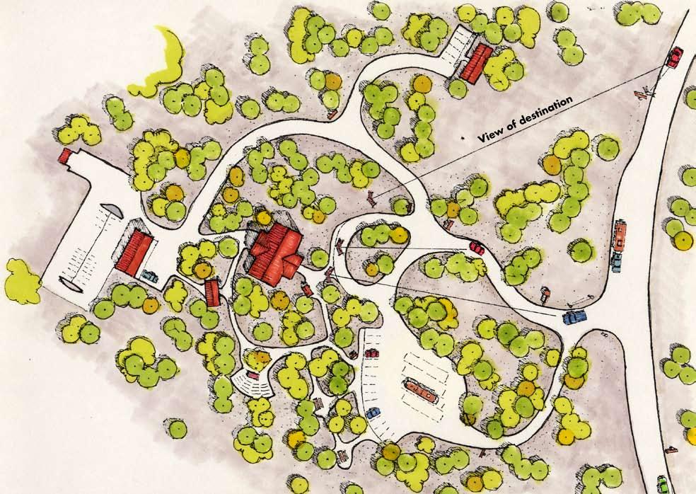
28 Recreational Opportunity Spectrum (ROS) Research has shown that people choose a specific setting for each recreational activity in order to realize a desired set of experiences. The ROS offers a framework for understanding these relationships and interactions. 22

29 23 ROS & Degree of Development Consider first the management ROS category of the area, along with other planning considerations such as an interpretive plan, before investing in significant efforts in the site planning, design, and subsequent development of the area.
30 Premise Our visitors arrive with a set of expectations. How we first greet them, through their visual observations of our signs and facilities or in person, form the basis of the image they will ultimately develop. Excitement and interest are high during the planning of a trip and during the early stages of a trip and will continue to grow or diminish according to how one s expectations are met. During a trip the first few observations of our facilities and attractions will determine the degree of interest for future stops. Let s ride along with a family and see what we can learn from their experience as it relates to our Image. 24

31 Meet The Griswolds The Griswold family from Moffet, Kansas, is spending its summer vacation traveling the Stokes Scenic Byway and camping on the Bedwell National Forest. Family Vacation Planned Itinerary Visit ranger station Visit the forest Travel the byway Visit the attractions, overlooks, campgrounds, the lake and the Bob Ross Wilderness Expectations Get more information and refine itinerary Sense of arrival Sightsee, photograph/learn about the resources and history of the forest and area Camp, explore, hike, fish, waterplay, etc. 25

32 Trip map for the Griswoldfamily vacation They will leave from Moffet, Kansas, and travel a day to get to Coffman City where they will stay overnight in a motel. They will visit the Myers Ranger Station the next morning for information and orientation. They will then travel to the entry portal for the forest, which also is the beginning of the Stokes National Scenic Byway, and stop to take pictures and get further information. They spend the next few days traveling the scenic byway visiting overlooks and wayside exhibits; camping, fishing, and hiking throughout the area. Their first stop after they have entered the scenic byway is at a scenic overlook. They have expectations for their trip which will be expanded or diminished by their visual observations, social experiences, impressions, and opinions formed during the vacation. 26 They will be going from urbanand rural-developed landscapes to natural and primitive landscapes.
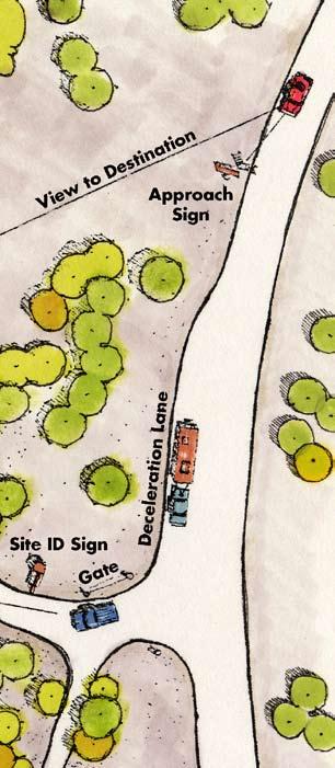
33 27
34 28

35 Ranger Station Stop 29
36 Ranger Station Site Plan The family s first stop will be at the Myers Ranger Station for forest and scenic byway information, orientation, and to read interpretative displays. They refine their itinerary at this stop. 30
37 31
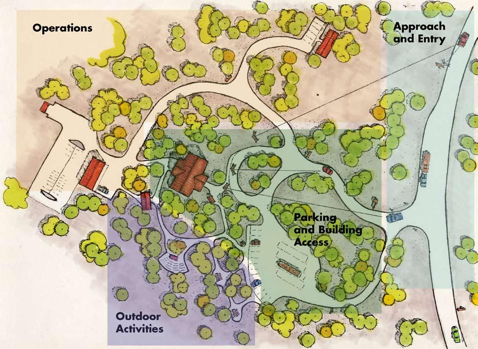
38 Myers Ranger Station Four Functional Zones Myers Ranger Station is an ideal facility that contains a full complement of services for the public and operations for administration. For the purpose of this discussion we will divide the ranger station into four functional zones: 1. Approach and entry 2. Parking and building access 3. Outdoor activities 4. Operations Each zone presents an image which is valued depending on how it looks, functions, and is designed. 32
39 33
40 Approach and Entry Zone The first function is a way-finding activity to find and enter the facility. The blow up shows the approach by vehicle and elements that should be considered when designing this part of the facility. A highway approach sign would be appropriate, accompanied by the full view of the facility from the road. Normally, a deceleration lane would be provided from a highway, and then a wide intersection where vehicles enter the site. A site identification sign should be prominent and easily read to confirm the sense of arrival. Fences and gates would be located as necessary. Definition: Way-finding: to find and enter the site 34 Elements: Approach Sign Site ID Sign Views to destination Intersection Fences Gates
41 35


42 36 Examples of an approach sign and a site identification sign

43 Parking and Building Access Zone Definition: Vehicle parking and pedestrian access Elements: Site orientation area Parking lot/walks Visibility of building and sense of arrival Directional signs The entry transitions into the parking and building access zone. It contains parking lots, walkways, visibility of facilities, and directional signs. 37


44 It should be clear where to park. It is also desirable to see the facility from the parking area. Well defined Entry visibility 38


45 Well designed access in two different buildings in which both are fully accessible. Appearance and aesthetics for the entry is critical. Remember, we only get one chance to make a first impression. Is there a sense of arrival? If Yes, this is when you know you have arrived. The facility and the entry is fully visible and designed to be inviting. Thus, a sense of arrival. 39

46 Outdoor Activities Zone Definition: Gathering and picnicking space Elements: Picnic tables Amphitheater Nature trail Interpretive signs/displays The composition of an outdoor activity area depends largely on available space. It provides opportunities for outdoor education and for visitors to rest and enjoy the surroundings. 40


47 Outdoor Activities Application of a design theme is critical to providing consistency and applying design principles of color, line, texture, and form. It will blend the facility into the characteristic landscape and borrow from the natural landscape. Use of fundamental design principles is critical in all aspects of the facility. The interior courtyard area is spatially defined by mature trees and shrubs in the understory. The small amphitheater blends well into the hillside and is appropriately scaled. 41

48 Operations Zone Definition: Administrative facilities Elements: Warehouse Storage buildings Fleet parking Outdoor storage Crew quarters 42


49 43 This example shows the three structures of the operations zone and depicts architectural themes and continuity for all structures.
50 Could the Griswold s find the station? Summary Ranger Station Stop Was parking and building access easy? Was their first impression a sense of arrival? Did they find the information they wanted? How helpful was the staff? As they looked at our facilities, what impressions did they have? 44
51 45
52 46

53 Forest Entry Portal/ Scenic Byway The first stop for the Griswold family after leaving the ranger station and Coffman City is the forest entry portal. This is also the beginning of a national scenic byway. An entry portal is defined as a boundary entry along a travel way normally containing a statement of identification and other information. It represents a very important sense of arrival, more so than the ranger station. The travelers should know they have arrived at their planned destination. 47

54 Entry Portal Site Plan Definition : Boundary entry along a travel way normally containing a statement of agency identification. Elements: Entry signs Optional: Parking Information/Orientation kiosk Approach signs Benches 48


55 Scenic Byway Entry Signs Shown here are scenic byway and forest portal entry signs. Two are modified Forest Service family-ofshapes signs. Information/Orientation An entry portal normally would contain an entry or identification sign. Other optional facilities could be information/orientation kiosks, parking benches, and approach signs. 49
56 What were the Griswold s expectations? What was their first impression of the forest? Summary Forest Entry Portal Stop Did they have a sense of arrival? Was the information and orientation provided adequate? Were the signs in good repair? 50
57 51
58 52

59 Overlook Stop 53

60 Overlook Site Plan The family proceeds along the Stokes Scenic Byway to the Speer s Overlook. Definition: A place that provides an observation platform to view the landscape or cultural features. Including: Parking Signs Dumpsters Restrooms Kiosks Walks/trails Benches Railings, and so on 54

61 Elements Overlooks may contain multiple improvements including parking areas, approach signs, directional signs, site ID signs, dumpsters, restrooms, interpretive kiosks and signs, accessible walkways, benches, and railings. The function of an overlook is to provide an observation platform to view the landscape or cultural features. It should be accessible, inviting, spatially adequate, and easy to circulate through. It should be located to maximize the view into the attraction and/or landscape panorama. Aesthetically, the viewing platform and other elements of the overlook should blend into its surrounding; borrowing from the textures, colors, and materials of its landscape setting. This is an oblique view of an overlook facility. It includes parking, walkways or paths, directional signs, restrooms, overlook site, and exhibits. 55


62 56 Approach Signs Definition: Signs that notify the traveler there is a point of interest ahead.


63 Parking Parking is also an overlook element. The design of the parking area should provide adequate room for an accessible walk in front of the wheel stops as shown to the left. The rock island is used to separate the parking area from the main travel way. 57


64 Restrooms These restrooms are designed to fit into their respective sites and complement their locations. Note the use of color in the example on the left. Restrooms should reflect a design theme based on the regional character. They should borrow from colors, lines, and textures found in the characteristic landscape to blend into and harmonize with the site. Always design for sustainability and accessibility. 58


65 59 These restrooms blend with color and local building styles. The middle one shows a Pennsylvania Lakes Provincial styles of lap siding, while the lower one demonstrates the use of native stone in the Rocky Mountain Province.


66 60 Viewing Decks Two overlooks in dramatically different settings that are designed for function and aesthetics.


67 Interpretive Kiosks Interpretive kiosks are significant design structural examples. The following are six examples of sensitively designed kiosks following individual design themes. The top kiosk is a good example of designing for image and identity. It shows art in design and makes a statement in the North Pacific Province. Look for opportunities to enforce or make a statement of area identity. The middle kiosk shows a creative divide between two forests as well as the interpretaiton on the Continental Divide. 61 Two examples of interpretive kiosks that follow design consideration of the respective areas. They have followed a design theme of using large timbers and stone masonry reflective of the Rocky Mountain Province.

68 62 This kiosk reflects the use of a CCC timber theme used on many of our traditional facilities.


69 63 These two kiosks have similar configurations in regard to the interpretive exhibits they provide.


70 64 Access Trails and Paths Surfacing For Accessible Trails and Paths The function of trails and paths is to provide access to portions of a facility. They can be constructed using compacted gravel, concrete, asphalt, or wood decking and other building materials.


71 65 Amenities Some amenities for access trails can include a small rest area, which may have benches and exhibits, or an interpretive book that addresses the area.


 Keep text brief (75 125 words maximum) Keep sign face simple and")
72 Interpretive Signs and Wayside Exhibits We communicate with more visitors through signs and interpretive exhibits than all other media combined. Today s variety of media allows graphic execution in full color. Some principles of effective graphic design and communication are: Select a design template or area theme to provide continuity, use only high quality graphics (art and photography) Keep text brief ( words maximum) Keep sign face simple and uncluttered Select material appropriate to theme and the exhibit location. 66


73 Design Guidelines: Follow a design theme Select an effective sign face medium Select the proper structural materials Sign supports should compliment the setting and theme 67
74 What were the Griswold s expectations? What was their experience and what impressions did they form? Summary Overlook Stop Was the site clean, accessible, and well designed? Was the information informative and helpful? What did they learn or feel after reading the exhibits? Were the text and graphics clear? Was the stop memorable? 68
75 69
76 70

77 Recreation Area Stop 71

78 After a day of sightseeing the Griswold s progress to a recreation area, Crabtree Meadows. They plan to camp for the next few days and use their campsite as a base to explore the area. Definition: A developed campground provides amenities for overnight camping: toilet, potable water, campsite with a fire ring, table, tent pad, RV hookup, and roads. It also should offer information about the area. It often serves as a base for other recreation activities such as biking, fishing, hiking, boating, and so on. 72


79 Site Approach Signs Campground and day use areas as well as other attractions should have site approach signs provided. A simple and recognizable International recreation logo would serve the need adequately. Site Identification Signs Site identification aids the Griswold s once they have entered the recreation area. These two nicely designed signs follow a design theme. One is fabricated in durable recyclable materials and has a beautiful sandblasted wood appearance. The other is a conventional Forest Service site identification sign. 73


80 74 Directional Signs Directional signs should be designed to be brief and bold. International recreation symbols are easily recognized while directional arrows and mileages are also helpful.


81 Information and Orientation Signs As people enter and use any of our recreation facilities, there is always a need to provide further information and orientation. Here are examples of two nicely designed sign displays in simple but effective kiosks. Panels can be added or subtracted in either as needed. 75 Fee Signs One of the first things our visitors see is a fee station which has professional appearing registries. They should be inviting, concise, clear, and well designed. A station can stand on its own or can be combined with other recreation area information, orientation, and regulations. Make them welcoming in appearance and easy to understand and use.


82 76 Bulletin Boards Within recreation areas and campgrounds we traditionally provide bulletin boards to provide supplemental information and notices. This is another opportunity to design an element that follows a design theme and presents a strong image. An important guideline is to manage the board, maintain a fresh and professional appearance, and include only what is necessary. The messages are designed to communicate simply and effectively. They should be inviting, easily read, and appear professionally done.


83 77 Campground Design Sensitive design of campgrounds is critical. The amenities should be blended aesthetically into the site and should be functional and accessible. The campground should also be designed to allow ecosystem function.


84 Campground Spurs In designing campground vehicle spurs, consider accessibility requirements and adequate width and depth required by today s variety of recreational vehicles. Campground Use Pads Tables, tent pads, and fire grates are standard furniture for a campground. The ROS should aid and guide the types provided. Provide functional, durable, and sustainable furniture. Bear in mind that people are living here. This is going to be their home away from home for a while. It should be comfortable, accessable, easy to circulate within, and aesthically pleasant. 78


85 79 Other Amenities Some other campground amenities could include table shelters and benches. Water hydrants are usually a standard requirement. These elements should also fit within a central design theme for the province and area.


86 80 In larger recreation areas some amenities could include amphitheaters, playgrounds, and fishing decks. As previously suggested, establish and follow a design theme that complements the area, BEIG, and the province.
87 81
88 What were the Griswolds expectations? Summary Recreation Area Stop What were their experiences and impressions? Would they return again? How did our facilities meet customer satisfaction? Were the facilities well designed, clean, and accessible? Did they feel safe and welcome at the campground? 82
89 83
90 84

91 Trailhead Stop 85

92 Trailhead Site Plan Definition: A trailhead is the beginning of a trail and a gathering spot. Elements: Parking trailheads vary in size from a wide spot in the road to a large developed site with car and trailer parking. Trail sign naming trail and giving tail length (milage) Restrooms Informational sign showing topographical and/or contextual map of area, you are here, what to expect, helpful hints, do s and don ts. Optional: Picnic tables Trash receptacles Water depending on the degree of development 86


93 Access and Identification Signs These are examples of site ID signs and a trailhead approach. Images and text again should be brief and graphically bold. Areas with special classification, such as wilderness, should be signed with appropriate designation and markers. 87


94 88 Trailhead Information and Orientation It is important, if not a legal responsibility, to give vital information to our visitors using primative areas or classified wilderness.


95 In trailheads the information/ orientation/registration is a critically important element. How do we look and communicate with the public? This is another element where we can repeat design theme. Registration When looking at the trailhead panels in detail, there are ways we can convey information by the use of icons (logos) and sensitive development of text that provides easily understood instructions, information, and orientation that can be absorbed by the reader quickly. This is much better than posters and papers which have been stapled up and seldom last more than a few weeks. 89
96 What were the Griswolds expectations? Did they feel welcome? Summary Trailhead Stop How did the facility work for the Griswolds? Were they able to find parking easily? Was the information and orientation of the area easy to understand and professionally presented? Were the trail condition and trail markers adequate? After their visit, will they want to come again or will they tell their friends or family about it? 90
97 91
98 92

99 Trip Ending and Forest Exit 93
100 The Griswold s left with what impressions? From their visual observations and social interaction, what are their impressions and opinions? What made it memorable? Good or bad? Did our facilities provide a positive image? How do we improve upon it? From their impressions and experiences, what was their FINAL IMAGE of the Forest Service? 94
101 95
102 What we provide for the public in facilities, opportunities, and experiences results in the formation of their impressions and opinions. These are the foundation of the mental image of the Forest Service that will remain with them. The appearance of built image elements reflects the quality of our management, stewardship, and the care that our agency provides for the land.
103
Review of Sign Standards
 Chapter 7 Chapter 7: Review of Sign Standards Review of Sign Standards for Alberta Parks Properties in 7.i the David Thompson Corridor Visitor Services Development Plan for the David Thompson Corridor
Image and the Built Environment
 Chapter 1 Image and the Built Environment A land ethic, then, reflects the existence of an ecological conscience, and this in turn reflects a conviction of individual responsibility for the health of the
Washington Pass Overlook
 Washington Pass Overlook The Washington Pass Overlook is located on the Methow Valley Ranger District on the Okanogan-Wenatchee National Forest. The overlook is at the crest of Washington Pass and is part
V. Gateways GATEWAYS / V-1
 V. GATEWAYS / V-1 Many of Chesapeake s gateways are located on highways and call for bold and attractive designs that motorists can understand, appreciate, and enjoy. can also take the form of natural
2011 ASLA Design Awards. Centennial Park Merit Award Design Concepts CLA, Inc. Design over $500,000 Construction Budget
 2011 ASLA Design Awards Centennial Park Merit Award Design Concepts CLA, Inc. Design over $500,000 Construction Budget 2011 ASLA Colorado Professional Design Awards Project Name: Category: Location: Const.
Daniels Park Master Plan
 Daniels Park Master Plan Prepared for: Douglas County & The City and County of Denver October, 2007 EXHIBIT A Contents Daniels Park Overview 2 Project History & Goals 2-3 Regional Context Map 4 Park Zone
Architectural Character Guidelines for the Nation and the Provinces
 Chapter 4 Architectural Character Guidelines for the Nation and the Provinces To build responsibly in the landscape should be the architect s first consideration. Javier Barba INTRODUCTION Chapter 4 is
Sign System Recommendations
 4.1 Sign System Recommendations 4.2 Recommended sign types required for a complete wayfinding system on the TCNJ campus are described below. Detailed sign messages and their typical locations are included
Worthington Scranton. Campus Exterior Architectural Plan
 Contents Introduction and Purpose Existing Conditions Inventory s Introduction and purpose The stated mission, vision and strategic goals of Penn State clearly define the University s responsibility to
ELK GROVE GENERAL PLAN VISION
 2-1 CHAPTER 2: 2-2 CREATING OUR The Community Vision for Elk Grove, expressed through a Vision Statement and a series of Supporting Principles, is a declaration of the kind of community that Elk Grove
7-PARKS, OPEN SPACE & PUBLIC ART
 7-s, Open Space & Public Art 7-PARKS, OPEN SPACE & PUBLIC ART This chapter provides recommendations for the expansion of new parks, plazas and open space that serve the many user groups targeted for downtown.
Goals & Objectives (best derived from an input
 Goals & Objectives (best derived from an input process) Goal - sets an intent of the project States the expected result or outcome of the project The trail will provide recreation and transportation opportunities
I-70 Corridor Enhancement Plan
 i - Table of Contents Table of Contents Chapter I Overview Chapter II Bridge and Roadway Improvements Chapter III Landscape Enhancements Chapter IV Riparian Corridors Chapter V Showcase Missouri Plan Chapter
CHAPTER FIVE COMMUNITY DESIGN
 CHAPTER FIVE COMMUNITY DESIGN CHAPTER FIVE - COMMUNITY DESIGN Assumptions Frazier Park and Lebec have historically developed according to different patterns of spatial form. While both communities are
12 Foot Davis and Adjacent Sites
 Peace River, Alberta Proposed Concept Design Presentation and Discussion January 26, 2010 Peace River Provincial Recreation Area 12 Foot Davis Grave Site Dr. Greene Cairn North Environments Landscape Architects
6.8 SCENIC HIGHWAYS Introduction
 6.8 SCENIC HIGHWAYS 6.8.1 Introduction The Scenic Highways Element is an optional General Plan element authorized by Section 65303 of the Government Code. The Scenic Highways Element is intended to establish
Phase 1 : Understanding the Campus Context. Phase 2 : APPROACHES - Alternates & Preferred Plan
 Introduction MASTER PLAN PURPOSE WHY A CAMPUS MASTER PLAN? The purpose of the Master Plan at the University of Illinois at Chicago is to translate UIC s strategic goals and objectives into a compelling
Port Lavaca Future Land Use
 Port Lavaca Future Land Use Introduction The City of Port Lavaca is beginning to see sustained growth, after many years of relative stable population. New single family homes, apartments, and businesses
BISCUIT RUN PARK MASTER PLAN
 BOARD OF SUPERVISORS November 14, 2018 BISCUIT RUN PARK MASTER PLAN COUNTY OF ALBEMARLE ANHOLD ASSOCIATES Contents Project Introduction Property Background County Park Planning Process Existing Site &
WELLINGTON STREET WEST COMMUNITY DESIGN PLAN
 36 3.CDP POLICIES 37 Wellington Street West CDP Vision Statement 38 3.1 Introduction 3.1.1 Purpose The development of buildings and public spaces is influenced by a variety of factors over time. City of
The analysis area for the scenic resource is the project area described in Chapter 1. Affected Environment/Existing Condition
 Chapter 3 - Scenic Resource SCENIC RESOURCES Introduction The Spotted Bear Ranger District is a destination point for outdoor recreation activities and offers a variety of recreation opportunities: driving
Section 4: Site Development Concepts
 Section 4: Site Development Concepts The overarching project goal is to make the Dry Falls site the major regional hub for telling the Ice Age Floods Story. The seven-acre site should function as a hub,
A Vision for Walnut Creek
 A Vision for Walnut Creek Photo: City of Clive Walnut Creek Booklet 8 of 8 Greater Des Moines Water Trails and Greenways 1 Table of Contents Booklet 1: Water Trails Strategies and Policies Booklet 2: Beaver
Galiuro Drilling EA Scenery Debby Kriegel 12/9/16
 Galiuro Drilling EA Scenery Debby Kriegel 12/9/16 INTRODUCTION The 1.7 million acre Coronado National Forest (CNF) is comprised of 12 sky island mountain ranges. CNF visitors have opportunities to sightsee
Dowdy Park. Concept Plans TOWN OF NAGS HEAD NORTH CAROLINA. Developed by: Albemarle & Associates, Ltd VHB/ Vanasse Hangen Brustlin, Inc.
 TOWN OF NAGS HEAD NORTH CAROLINA Concept Plans Developed by: Albemarle & Associates, Ltd VHB/ Vanasse Hangen Brustlin, Inc. Site Looking Southeast Dowdy Park Existing Conditions Nags Head Woods Sound Future
2 Vision. Master Plan
 19 2 Vision Master Plan 20 Chapter 2 MASTER PLAN VISION 2.1 Master Plan Organization Lake Calhoun/Bde Maka Ska and Lake Harriet are places where complex human and natural systems intersect and converge.
AESTHETIC APPEARANCE. Design Guidelines for Grade-Separated Pedestrian, Cyclist and Equestrian Structures
 III. AESTHETIC APPEARANCE The aesthetic qualities of a grade-separated structure are as important as the specific design criteria. For example, a structure may be constructed to the exact criteria set
ACADEMY AREA CONCEPT PLAN
 ACADEMY AREA Strip ling C hape l Roa d CONCEPT PLAN 7 S2 U Stripling 52 ROADWAYS AND PARKING: ADVENTURE PLAYGROUND AND SPRAYGROUND: Current roadways follow existing drives. It is recommended that the Folds
Chapter 5: Recreation
 Chapter 5: Recreation Introduction and Setting Recreational opportunities within Nevada County are varied, ranging from public parks with intensively used active recreational facilities, to vast tracts
2011 ASLA Design Awards. Top of the Rockies National Scenic and Historic Byway Merit Award Bluegreen. Planning & Urban Design
 2011 ASLA Design Awards Top of the Rockies National Scenic and Historic Byway Merit Award Bluegreen Planning & Urban Design ASLA Colorado 2011 Design Awards Category 2: Planning Project Fact Sheet Project
HOLLERING PLACE MASER PLAN Concept for Development
 HOLLERING PLACE MASER PLAN Concept for Development Current Status of the Historic Hollering Place Development Project The city did not receive a responsive proposal for the Historic Hollering Place Development
MARINA MARKET & WATERFRONT DEVELOPMENT STUDY PORT ARANSAS, TEXAS
 MARINA MARKET & WATERFRONT DEVELOPMENT STUDY PORT ARANSAS, TEXAS FEBRUARY 2015 PRESENTATION OUTLINE 1 2 3 4 5 6 7 REGIONAL POSITIONING SITE IMPRESSIONS PLANNING & DESIGN PRINCIPLES EXISTING IMPROVEMENTS
GUIDELINES REPLACEMENT HOUSING GUIDELINES LOCATION INTRODUCTION URBAN DESIGN GUIDELINES
 Replacement housing in the former City of North York will be consistent with the following urban design guidelines. They provide a framework for residential re-development in the former City of North York
the village at market creek
 the village at market creek executive summary october 2012 i ii introduction The Village at Market Creek is primed to grow into one of San Diego s most lively, multi-cultural arts destinations. Our community
CHAPTER 7: Transportation, Mobility and Circulation
 AGLE AREA COMMUNITY Plan CHAPTER 7 CHAPTER 7: Transportation, Mobility and Circulation Transportation, Mobility and Circulation The purpose of the Transportation, Mobility and Circulation Chapter is to
Visual Impact Rating Form - Instructions
 Visual Impact Rating Form Instructions Project Name: Baron Winds Project EDR Project No: 13039 Date: 05.16.17 Reference: Visual Impact Rating Form - Instructions These instructions are intended to guide
CHAPTER ADDITIONAL REQUIREMENTS IN THE NC, NEIGHBORHOOD COMMERCIAL ZONE
 CITY OF MOSES LAKE MUNICIPAL CODE CHAPTER 18.31 ADDITIONAL REQUIREMENTS IN THE NC, NEIGHBORHOOD COMMERCIAL ZONE Sections: 18.31.010 Purpose 18.31.020 Minimum Lot Area 18.31.030 Setbacks 18.31.040 Maximum
VEHICULAR AND PEDESTRIAN CIRCULATION
 This perspective sketch communicates the intended character and quality of a proposed streetscape design. Locate benches near a major intersection where people tend to gather. Seating and lighting provide
Connecting people to parks
 Connecting people to parks Introduction from the Governor It is up to all of us to ensure the conservation of our State s wonderful national parks, marine parks and other conservation reserves continues
SECTION ONE: INTRODUCTION. introduction
 introduction 1 INTRODUCTION Since it was first established in 1843 as a trading post for the Hudson s Bay Company, Victoria has evolved into a Provincial capital city that is recognized across Canada and
SUBCHAPTER 4-B GUIDELINES FOR THE B-3 COMMERCIAL CHARACTER AREA
 1 SUBCHAPTER 4-B GUIDELINES FOR THE B-3 COMMERCIAL CHARACTER AREA Downtown Bozeman should be the location of buildings of greatest height and intensity in the community. The following guidelines apply
Public Art Plan. We have elected to submit Public Art Plans before or concurrently with the CSP Submittal per the FDP Manual
 Public Art Plan The intent of the Horizon Uptown Public Arts Program is to create great places that engage the community and leverage the neighborhood development and economic vitality. The Horizon Uptown
GUIDING PRINCIPLES IN THIS CHAPTER
 GUIDING PRINCIPLES The guiding principles and design concepts in this chapter work together with the Chapel Hill 2020 Comprehensive Plan to support new public places that can be enjoyed by all while also
City of Kingston Heritage Commemoration Program Guidelines: 7 May 2010
 MHC-13-010 Exhibit B City of Kingston Heritage Commemoration Program Guidelines: 7 May 2010 These guidelines cover three separate types of city heritage commemoration: small markers on designated property.
A Vibrant Downtown. Chapter 5 Cary Public Art Opportunities 31
 A Vibrant Downtown Cary s vision for Downtown is a unique, vibrant, dynamic, pedestrian friendly location; a regional destination and a place to live, work, and recreate, according to the 2001 Town Center
Las Colonias Park Master Plan
 2013 Las Colonias Park Master Plan City of Grand Junction June 2013 Introduction Las Colonias Park, a 101 acre parcel on the edge of the Colorado River south of downtown, was deeded to the City of Grand
Regional Context Statement
 Regional Context Statement REGIONAL CONTEXT STATEMENT 3. REGIONAL CONTEXT STATEMENT In 1995, the Provincial Government passed into law the Growth Strategies Act. The purpose of this provincial initiative
BACKGROUND INFORMATION
 13 BACKGROUND INFORMATION PARK OVERVIEW Quail Hollow Park exists today as a natural escape. The historic estate remains true to its 1930s character, as evident in the Manor House, but the surrounding site
6-GATEWAYS, WAYFINDING & PUBLIC SIGNS
 6-GATEWAYS, Wayfinding & ublic Signs 6-GATEWAYS, WAYFINDING & UBLIC SIGNS Downtown Georgetown has a strong base of local users as well as seasonal tourists and visitors. Many first-time visitors, and those
PARTF Scoring System for Grants
 PARTF Scoring System for Grants The members of the N.C. Parks and Recreation Authority use the PARTF scoring system as one of several tools to select grant recipients. Please provide all of the information
City of Farmington. Downtown Plan. Amendment to the 1998 Master Plan Adopted October 11, 2004
 City of Farmington Amendment to the 1998 Master Plan Adopted October 11, 2004 Introduction Planning Background 1 Scope and Components of the Plan Amendment 2 Concept Introduction 3 Plan Concepts 3 Conceptual
ANCHORAGE PARK REPORT CARD Assessing A Park s Appearance, Function, & Condition
 ANCHORAGE PARK REPORT CARD Assessing A Park s Appearance, Function, & Condition Park Name: Is Your Park an A or an F? Your Name: Contact Information Optional: Date: General Instructions: Phone: Email:
Creating Quality Places: Successful Communities by Design
 Creating Quality Places: Successful Communities by Design Communities across the metropolitan Kansas City area are growing. Our challenge is to shape future development in ways that will maintain and enhance
BURTON STATION STRATEGIC GROWTH AREA PLAN UPDATE PUBLIC MEETING 3/26/18
 BURTON STATION STRATEGIC GROWTH AREA PLAN UPDATE PUBLIC MEETING 3/26/18 1 WHERE WE ARE? 2 PRIMARY OBJECTIVES OF THE PLAN UPDATE 1. Update the land use designation for Burton Station Village to reflect
Preliminary Sketch Plan for Fort Hunter Park
 Preliminary Sketch Plan for Fort Hunter Park Public Presentation November 19, 2009 Dauphin County Parks and Recreation 100 Fort Hunter Road Harrisburg, PA 17110 (717) 599-5188 www.dauphinc.org THOMAS COMITTA
Appendix A COMMUNITY IMPROVEMENT PLAN DESIGN GUIDELINES
 Appendix A COMMUNITY IMPROVEMENT PLAN DESIGN GUIDELINES INTRODUCTION The continuous and desirable improvement of Arnprior requires a clear understanding of what is envisioned for the Town. These Design
Saratoga Quarry Park Master Plan
 Project Team City of Saratoga John Cherbone, Director of Public Works Iveta Harvancik, Senior Engineer PlaceWorks Isabelle Minn, Principal-in-Charge Isby Fleischmann, Project Manager Kyle Simpson, CEQA
SAN FRANCISCO. and. A Sampling of Installations in San Francisco, California
 SAN FRANCISCO and A Sampling of Installations in San Francisco, California Buena Vista Park City and County of San Francisco It was known as Hill Park in 1867 when San Francisco s Committee on Outside
East Bayshore Road Neighbourhood
 East Bayshore Road Neighbourhood Northridge Property Management Urban Design Brief 3195 East Bayshore Road City of Owen Sound January 2016 East Bayshore Road Neighbourhood Northridge Property Management
A New St Mary s Music School
 A ew St Mary s Music School at the Former Royal High School Landscape Design and Access Statement 150863_OPE_RHS_LDAS-01 December 2015 contents 1 introduction p. 4 site context p. 6 site photography and
Reconnecting to a Forgotten River St. Cloud MN. Aaron Hanson Design Design Thesis LA 572, Thesis, Spring 2012
 Reconnecting to a Forgotten River St. Cloud MN Aaron Hanson Design Design Thesis LA 572, Thesis, Spring 2012 site context 2.5 Miles Sartell St. Cloud to Fargo 170 Miles (2 hrs 45 mins) Hwy 10 infrastructure
CITY OF BEACON NOTICE TO LANDSCAPE ARCHITECTS GENERAL INFORMATION AND REQUEST FOR PROPOSALS
 CITY OF BEACON NOTICE TO LANDSCAPE ARCHITECTS GENERAL INFORMATION AND REQUEST FOR PROPOSALS The City of Beacon (the CITY) is issuing this Request for Proposals (RFP) for the selection of a landscape architect
HISTORIC SITE AND MONUMENT COMMISSION (HSMC) Instructions for Historical Markers, Monuments, and Public Art Application
 Instructions for Historical Markers, Monuments, and Public Art Application") HISTORIC SITE AND MONUMENT COMMISSION (HSMC) Instructions for Historical Markers, Monuments, and Public Art Application This document is for information purposes only and does not need to be submitted
HISTORIC SITE AND MONUMENT COMMISSION (HSMC) Instructions for Historical Markers, Monuments, and Public Art Application This document is for information purposes only and does not need to be submitted
97 Lea Bridge Road, Leyton, E10 7QL London Borough of Waltham Forest December 2015
 97 Lea Bridge Road, Leyton, E10 7QL London Borough of Waltham Forest December 2015 Public Realm and Landscape Proposals LEA BRIDGE ROAD, WALTHAMSTOW Public Realm & Landscape Proposals BDP(90)RPT001 December
APPENDIX K WINDSOR OFFICIAL PLAN
 CEAA ENVIRONMENTAL ENVIRONMENTAL IMPACT ASSESSMENT AMBASSADOR BRIDGE ENHANCEMENT PROJECT Replacement Span and Plaza Expansion APPENDIX K WINDSOR OFFICIAL PLAN Avalon Consulting Professionals of Ontario,
BUSINESS DISTRICT DESIGN GUIDELINES
 Des Plaines, Illinois Prepared for the City of Des Plaines by: The Lakota Group Laurie Marston, AICP March 2005 Section 5: Streetscape Elements Business District Design Guidelines STREETSCAPE ELEMENTS
WINDSOR GLEN DESIGN GUIDELINES
 WINDSOR GLEN DESIGN GUIDELINES Adopted by Council, 2006 WINDSOR GLEN REDEVELOPMENT DESIGN GUIDELINES August 2006 1.0 Master Plan Organization For this area of the Coquitlam Town Centre, a mix of high,
Campus Identity & Design Guidelines
 WSU RFP 7840-GC23215 Exhibit E Campus Identity & Design Branding Specification Washington State University Tri-Cities Campus Campus Identity & Design Guidelines G G L O architecture I interior design I
B L A C K D I A M O N D D E S I G N G U I D E L I N E S for Multi-family Development
 B L A C K D I A M O N D D E S I G N G U I D E L I N E S for Multi-family Development Adopted June 18, 2009 This section of the Design and focuses on site planning and design guidance for new multi-family
Classroom Science Building
 Classroom Science Building Public Realm Presented by: Gary Branville, Joe Moore, Justin Rechtzigel, Tom Roth & Hailey Wall Proposal Objective: To create a node on the Grand Rounds Parkway Connect the public
St. Anthony Parkway Bridge Over Northtown Yard Project S.P. No
 St. Anthony Parkway Bridge Over Northtown Yard Project S.P. No. 141-454-01 Questions & comments made by attendees during the Public Meeting held on April 9, 2013. How will the existing bridge be removed
FLORIN ROAD CORRIDOR Site Plan and Design Review Guidelines Checklist
 FLORIN ROAD CORRIDOR Site Plan and Design Review Guidelines Checklist Applicant s Name: Project Address: Phone: Email: Applicant shall fill out the design guidelines checklist for all guidelines applicable
River Bend Area Plan Map Amendment ARPP Analysis Camp Fire Day Camp November 20, 2014
 Regional Parks Department Jeffrey R. Leatherman, Director County of Sacramento Attachment 2 Divisions Administration Golf Leisure Services Maintenance Rangers Therapeutic Recreation Services River Bend
OPEN SPACE AND RECREATION
 OPEN SPACE AND RECREATION The Town celebrates and maintains the spectacular visual character of our Sonoran Desert setting and we value our open space, mountain views, washes, vegetation, and wildlife.
FRUITVALE TRANSIT VILLAGE (Phase 2) Residential Project
 Residential Project") FRUITVALE TRANSIT VILLAGE (Phase 2) Residential Project DEVELOPER: SIGNATURE PROPERTIES ARCHITECT: HKIT ARCHITECTS April 23, 2010 TABLE OF CONTENTS 3 Vision 4 Description of Site 5 Guiding Concepts 6
FRUITVALE TRANSIT VILLAGE (Phase 2) Residential Project DEVELOPER: SIGNATURE PROPERTIES ARCHITECT: HKIT ARCHITECTS April 23, 2010 TABLE OF CONTENTS 3 Vision 4 Description of Site 5 Guiding Concepts 6
Castle. Lake. on the. Osterfelds enjoy their unique Jocassee getaway. Written by Leigh Savage Photography by Kris Decker/Firewater Photography
 athome SUMMER 2014 Castle on the Lake Osterfelds enjoy their unique Jocassee getaway Written by Leigh Savage Photography by Kris Decker/Firewater Photography 94 athome SUMMER 2014 95 When most people think
13. New Construction. Context & Character
 13. New Construction Context & Character While historic districts convey a sense of time and place which is retained through the preservation of historic buildings and relationships, these areas continue
PARKLET PROPOSAL PACKAGE & PROCESS
 500.3 I PARKLETS The term parklet refers to a small temporary constructed seating or community gathering area over an on-street parking space or an extension of the sidewalk into the operating State highway
Popp s Ferry Causeway Park Back Bay Environmental Educational Center CASHIO COCHRAN LLC
 Popp s Ferry Causeway Park Back Bay Environmental Educational Center CASHIO COCHRAN LLC A LIMITED LIABILITY COMPANY Popp s Ferry Causeway Park Master Plan Prepared for: City of Biloxi Department of Parks
Chapter 7: Streetscape & Design Elements
 OVERVIEW Chapter 7: Streetscape & Design Elements During the public input phase of The Dixie Fix, the area of streetscape generated much interest. While safety and traffic flow are primary objectives of
BEMIDJI CITY COUNCIL Work Session Agenda Monday July 9, 2012
 BEMIDJI CITY COUNCIL Work Session Agenda Monday July 9, 2012 City Hall Conference Room 5:30 p.m. 1. CALL TO ORDER / ROLL CALL 2. REVIEW PARK PLANS FOR PAUL BUNYAN PARK, LIBRARY PARK AND SOUTH SHORE BAUER
Summary of Changes in the DRAFT Rivers Project Natural Resource Master Plan from the 2001 approved plan to 2014 plan
 Summary of Changes in the DRAFT Rivers Project Natural Resource Master Plan from the 2001 approved plan to 2014 plan The entire Master Plan format and layout has been changed to comply with regulation
The Vision. Photo provided by The Minervini Group. 46 Vision, Objectives & Strategies
 Vision, Objectives & Strategies The is the public framework and guide for future development of the Grand Traverse Commons. The establishes public polices for infrastructure, the preservation of natural
Policies and Code Intent Sections Related to Town Center
 Policies and Code Intent Sections Related to Town Center The Town Center Vision is scattered throughout the Comprehensive Plan, development code and the 1994 Town Center Plan. What follows are sections
Principles of Landscaping
 Principles of Landscaping 1. Definition of Landscaping Landscaping is a branch of horticulture and is an important field in which architecture, art and knowledge are combined to achieve beauty and utility.
Route 347. New York State Department of Transportation Region 10, Long Island. THE GREENING of ROUTE 347
 The GREENING of Route 347 The Greening of Route 347 The Greening of Route 347: History 3 The Greening of Route 347 4 The Greening of Route 347 5 The Greening of Route 347 Smith Haven Mall 6 The Greening
New-Cast Mixed-use Development Proposal King Street West, Newcastle, Ontario
 URBAN DESIGN BRIEF New-Cast Mixed-use Development Proposal King Street West, Newcastle, Ontario TABLE OF CONTENTS: 1.0 Executive Summary 2.0 Creating Vibrant and Sustainable Urban Places: Excerpts from
Eastcreek Farm. Planned Development Standards September, 2014
 Eastcreek Farm Planned Development Standards September, 2014 ekfarm Contents 01. General Standards 02. Residential Development Standards 03. Architectural Design Standards 04. Landscape Design Standards
Project purpose. advise. The purpose of the Beaumaris Lake Open Space Rehabilitation project is to: + Develop a Functional Program Concept
 Project purpose owns Road Beaumaris Road The purpose of the Beaumaris Lake Open Space Rehabilitation project is to: + Develop a Functional Program Concept + Guide Rehabilitation of Landscape and Community
Section 4: Goals, Objectives, and Strategies
 99 Section 4: Goals, Objectives, and Strategies Goal 1 Resource Protection, Maintenance, Preservation, and Enhancement Protect, preserve, maintain, and enhance the natural, recreational, archaeological,
Streetscape Patterns. Design Guidelines, Ridgewood Village Center Historic District, Ridgewood, N.J. page 20
 North Broad Street has a unique streetscape pattern with broad curving street, tight enclosure on the east side with attached commercial buildings aligned with the sidewalk, and landscaped open space on
4.9 Mendocino Avenue Corridor Plan Design Guidelines
 4.9 Mendocino Avenue Corridor Plan Design Guidelines The Mendocino Avenue Corridor Plan addresses the area between College Avenue and Steele Lane. Mendocino Avenue is a busy arterial that runs parallel
Corridor Identity. Section 9. Introduction. Corridor Guiding Principles
 Corridor Identity An attractive and healthy community is a critical element of a quality place, and the design of quality places is a balance between environmental, economic, and social considerations.
Niagara National Heritage Area
 Niagara National Heritage Area What is a National Heritage Area? It is a regional place where natural, cultural, historic and recreational resources combine to form a nationally distinctive landscape and
COMMERCIAL & INDUSTRIAL DESIGN GUIDELINES CITY OF RANCHO CUCAMONGA PLANNING DIVISION
 COMMERCIAL & INDUSTRIAL DESIGN GUIDELINES CITY OF RANCHO CUCAMONGA PLANNING DIVISION INTRODUCTION These guidelines were prepared in response to the needs of many users: developers, property owners, architects,
Philip A. Ginsburg, General Manager Toks Ajike, Acting Planning and Capital Program Director
 Date: March 7, 2018 To: Through: From: Subject: Recreation and Park Commission Capital Committee Philip A. Ginsburg, General Manager Toks Ajike, Acting Planning and Capital Program Director Dan Mauer,
REZONING APPLICATION MPD SUPPLEMENT
 REZONING APPLICATION MPD SUPPLEMENT For Staff Use Only: DATE/TIMESTAMP: ZA# RECEIVED BY: The intent of the Master Planned District (MPD) designation is to allow flexibility in the design and construction
City of Redlands Architectural Guidelines for Non-Residential Development
 14. Building articulation shall be included in the design of building, in order to create a formal entry statement. Avoid this Do this Page 11 15. Give special attention to creating pedestrian scale and
Silverdale Regional Center
 Silverdale Regional Center Vision for Silverdale Regional Center The Silverdale Regional Center Plan (Plan) will guide the evolution of the Silverdale Regional Center from a collection of strip malls and
section five BEAUTIFICATION PLAN
 section five BEAUTIFICATION PLAN BEAUTIFICATION PLAN Section Five Beautification Plan The goal of the Beautification Plan is to improve the Route 8-Sunnyland Corridor in terms of aesthetics and to create