BACKGROUND INFORMATION
|
|
|
- Rebecca Richardson
- 5 years ago
- Views:
Transcription

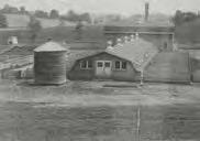
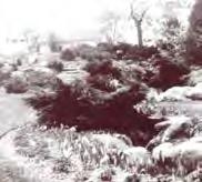
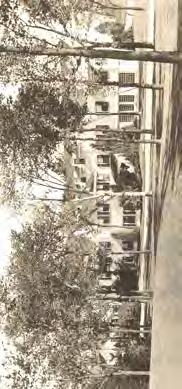
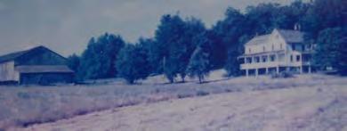
1 13 BACKGROUND INFORMATION PARK OVERVIEW Quail Hollow Park exists today as a natural escape. The historic estate remains true to its 1930s character, as evident in the Manor House, but the surrounding site has returned to a state that precedes even the Brumbaugh family. What was once a heavily worked, open farmland has become, once again, a vista of scenic forests, prairies, wetlands, and grasslands. About one mile south of the Portage County line, on Congress Lake Road, a single sign can be found that designates the main and only public entrance to Quail Hollow Park. This park has become one of the few naturalized areas within the largely suburban Village of Hartville and rural expanses of Lake Township. It contains expanses of woodlands, meadows, marshes, wetlands, and a variety of ecological zones that house historic buildings, two residences, and numerous trails; all of which provide a glimpse into over 200 years of rich cultural and natural history. PARK HISTORY Quail Hollow Park offers a glimpse into the lives of the earliest inhabitants of Ohio, Stark County, and the Village of Hartville. Its lasting structures offer remnants of the past that give insight into the history of the Brumbaugh, Rubright and Stewart families that may have otherwise been lost. The importance of understanding and preserving this history cannot be overstated. The maintaining of the preservation efforts at Quail Hollow Park will not only educate the public, but also generate respect for the legacy and hard work of those who made Stark County what it is today. The park and its history convey lasting value and accomplishment, critical to the sense of community and pride that are fundamental to the region s quality of life and achievements. The history of the park gives life and meaning to each building and to the people associated with these structures that provide a tangible link to the past; the two work in tandem. From the main entrance, the winding drive continues east, where the Levitt House can be seen through the trees. Adjacent to this residence, a primitive group camp area, accommodates up to 30 people and includes a fire ring, parking area and picnic tables. Continuing east, a linear parking lot, small playground, basketball hoops and open greenspace surround a small pond to make up the area known as Shady Lane. Located at the center of the park, this open space offers recreation to the youngest of the visiting park guests. The entrance drive continues further east past forests and prairie grass before reaching a clearing that overlooks the historic Manor House, Carriage House, and Caretaker s House. These historic buildings are accompanied by several maintenance sheds, a fire circle, pavilion, herb garden and historic rock garden. Picnic areas are scattered throughout the park, situated adjacent to the Manor House, pond, and gardens, with grills and a vault restroom located nearby. These amenities provide quiet relaxation, as well as excellent views to the surrounding natural and historic elements that make up the heart of the park. Though the main circulation route dead ends at the Carriage House, a small drive continues on past the elms, to the Little House. Beyond the house, the northern portion of the park contains a bird sanctuary, vernal pools, and varying types of coniferous and deciduous trees. Miles of mountain bike trails, equestrian trails, hiking trails, and multi-use trails are scattered throughout all areas of the park. Even the Buckeye Trail utilizes the extensive trail network prior to continuing north to Summit County. Cross country skiers utilize the entire trail system if the weather and trail conditions allow. The Nature of All Trail, composed of asphalt, is an interpretive trail, accessible to handicapped users. Under Stark Parks management, multiple activities are offered at Quail Hollow Park. Park guests can tent camp in the group campground, fish or play basketball or volleyball at the Shady Lane Pond, explore the many trails, or experience the natural and historic features of the park through nature programming and historic tours. Stewart Farm - Aerial View 1950


2 14 HISTORIC TIMELINE Conrad Brumbaugh settles in Stark County, He and his family build a small, two-story cabin, located nearby the present-day Brumbaugh Cemetery. The Brumbaughs construct a much larger home on the ridge of a hill, in addition to a summer house, courtyard, and large barn. Conrad Brumbaugh dies and is buried at the present day Brumbaugh Cemetery. His son Lewis and his wife care for the property in his place. William and Mary Rubright purchase a portion of the presentday Quail Hollow. They construct the red, white & blue home which would become the presentday Manor House. Harry Bartlett Stewart and his wife Minnie begin the acquisition of the property at Quail Hollow. Initially, the Stewarts used the homestead for a hunting camp. The red, white & blue house is expanded into the present-day manor house and completed in It housed 3 generations of the Stewart family.


 purchases the property.")
3 Following his landscape design at Stan Hywet, Warren Manning implements his design philosophies into the landscaping work he completed at Quail Hollow. Harry Bartlett Stewart II and his wife Catherine Seiberling Stewart are given The Little House as a wedding present, where they both lived until Harry Stewart Sr. s death in Although it never materialized, a proposal was drafted to turn the property into a 27-hole golf course. If such had occurred, it is likely that Quail Hollow Park would not exist. The original Brumbaugh house is destroyed in a fire. Its foundations can still be seen at the park today. ODNR (Ohio Department of Natural Resources) purchases the property. The Stark County Park District takes over management of the property, making the park one of the largest in Stark County.
4 16

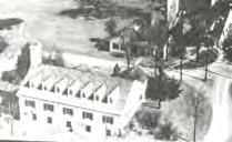
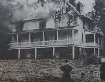
5 17 HISTORIC TIMELINE Early Hartville was inhabited by mound builders, a prehistoric group of native Americans who settled along Congress Lake. The Delawares, however, were the first major tribe known to inhabit the area until the early 1800s Conrad Brumbaugh and his family settle in at the present-day Quail Hollow, where they build a small, two-story cabin just east of the present-day Brumbaugh Cemetery The Brumbaughs construct a much larger home on the ridge of a hill, in addition to a summer house, courtyard, and large barn Conrad Brumbaugh dies and is buried at the present-day Brumbaugh cemetery. His son Lewis and his wife care for the property in his place William and Mary Rubright purchase a portion of the present-day Quail Hollow. They construct the red, white, and blue home which would become part of the present-day Manor House Harry Bartlett Stewart and his wife Minnie begin the acquisition of the property of Quail Hollow. Initially, the Stewarts used the homestead for a hunting camp The red, white and blue house is expanded into the presentday Manor House, which was completed in It housed three generations of the Stewart family. Their estate was expanded to include a Carriage House, caretaker s house, church and multiple homesteads and farms over the course of their residence Following his landscape design at Stan Hywet Hall, Warren Manning implements his design philosophies into the landscaping work he completed at Quail Hollow Harry Bartlett Stewart II and his wife Catherine Seiberling are given The Little House as a wedding present, where they both lived until Harry Sr. s death in Although it never materialized, a proposal was drafted to turn the property into a 27-hole golf course. This plan was one option of three that were developed as follows: 1. The Manor House would become an interpretive nature center, with a day camp, picnicking facilities, and a par-three golf course. 2. The property would be developed as a typical state park. The house would be remodeled to become an overnight lodge with an interpretive nature center, picnicking areas, and overnight camping. 3. The property would become a recreation-oriented park with the Manor House becoming a clubhouse for a golf course. This plan would include vacation cabins and trails for horseback riding. The site was one of the most intriguing I have ever encountered in looking at literally hundreds of golf course sites. I have never seen a terrain so replete with natural green sites and potentially challenging golf holes. The natural flow of the land invites the creation of exceptionally beautiful sequences of holes. Robert Trent Jones, Sr When Bart Stewart determined that the original Brumbaugh home was far beyond repair, he collaborated with the local fire departments in an effort to train its volunteer members via a controlled fire. The Hartville fire chief invited the Stark County, Uniontown, North Canton, Lexington, and Marlboro fire departments to come practice their firefighting techniques while safely razing the old home. Its foundations can still be seen at the park today ODNR purchased the property in 1975 making Quail Hollow Park, Stark County s first state park. Harry Bartlett II (Bart) donated about half of the appraised value in arranging this purchase. This purchase ensured the preservation of a significant amount of natural, open space during a time of frequent developmental growth. As a part of the sale, the Stewart Family required preservation of the Brumbaugh Cemetery and a wildlife sanctuary along Pontius Street The estate, including the Manor House, Caretaker s House, Carriage House, Little House and Cemetery, became certified as a property in the National Register of Historic Places. The boundaries have been drawn to include four related structures and the Conrad Brumbaugh family cemetery, or about 150 of the original 690 acres. Statement of significance: The H.B. Stewart Property is significant as a composite of two architectural impulses the eclectic revival mode practiced in architect-designed elite dwellings of the 1920 s as interpreted, uniquely here, through what is essentially a local house type, the vernacular Greek Revival or Western Reserve style. It is significant, as well, in that it translates the financial success of east-central Ohio business magnates into dwellings presumed appropriate to their station Stark Parks signed a 30-year management agreement with the Ohio Department of Natural Resources. Quail Hollow Park - view from Great Lawn
BISCUIT RUN PARK MASTER PLAN
 BOARD OF SUPERVISORS November 14, 2018 BISCUIT RUN PARK MASTER PLAN COUNTY OF ALBEMARLE ANHOLD ASSOCIATES Contents Project Introduction Property Background County Park Planning Process Existing Site &
PEQUITSIDE FARM ONE PROPERTY, MANY USES
 PEQUITSIDE FARM ONE PROPERTY, MANY USES Laura Campbell March 8, 2016 A plan for the public use of a historic estate Introduction At 33 acres, Peuitside Farm is the largest public owned open space in the
Portage County Parks, Trails and Greenways Plan
 Portage County Parks, Trails and Greenways Plan Agenda for Local Planning Meeting Introductory Presentation Why we need a Plan Plan project goals and process Benefits Overview of local planning region
SEWRPC OUTDOOR RECREATION AND OPEN SPACE PLANNING OBJECTIVES, PRINCIPLES, AND STANDARDS
 SEWRPC OUTDOOR RECREATION AND OPEN SPACE PLANNING OBJECTIVES, S, AND STANDARDS Introduction The Southeastern Wisconsin Regional Planning Commission (SEWRPC), as part of the regional park and open space
QUAIL HOLLOW PARK MASTER PLAN
 QUAIL HOLLOW PARK MASTER PLAN Summary Report June 2017 ACKNOWLEDGEMENTS Thank you to the following Project Team members who contributed their time and expertise in effort to complete the Master Plan for
UPPER BRODHEAD CREEK PARADISE CREEK GREENWAY PLAN
 UPPER BRODHEAD CREEK PARADISE CREEK GREENWAY PLAN The Upper Brodhead & Paradise Creeks Greenway Cooperating Municipalities Mount Pocono Borough Paradise Township Barrett Township Price Township Funding
APPENDIX D: PARKS AND RECREATION ACTION PLAN
 APPENDIX D: PARKS AND RECREATION ACTION PLAN Goals The following goals are specific to the development, maintenance, and operation of the existing parks in the Township, as well as the acquisition and
SOUTH PARK. Construction of a Portion of South Park at Fresh Kills Park, Staten Island
 SOUTH PARK Construction of a Portion of South Park at Fresh Kills Park, Staten Island FRESHKILLS PARK FIRST PHASE OF SOUTH PARK FRESHKILLS PARK CONTEXT SOUTH PARK EXISTING CONDITIONS PROJECT OPPORTUNITIES
Mendota Heights 2040 Comprehensive Plan Draft Vers
 4 Parks and Trails The City of Mendota Heights boasts a variety of recreational and open space opportunities. Few cities can claim access to regional trails, riverside and lakeside parks, scenic bluffs
WATERLOO RECREATION AREA PHASE 2 LONG-RANGE ACTION GOALS. September 2012
 September 2012 PHASE 2 LONG RANGE ACTION GOALS PLAN Long-range management guidance focused on the specific natural resources, historic-cultural resources, recreation opportunities and the education-interpretation
11: Good Design - Boor Site
 Rural Design Workbook: 11: Site Introduction: A dairy and feed farm of over 450 acres in the town of Horseheads (Chemung County), David Boor s property has a number of notable features. The site is nearly
The following principles guide the development of goals and strategies to protect and promote these amenities:
 OPEN SPACE/PARKS/TRAILS/RECREATION GOALS/STRATEGIES Cherry Hills Village is a living environment that offers low density development, open areas, public scenic vistas, public trails and public parks. This
SCC PRD (2016) COUNTY PARK MASTER PLAN
 COUNTY PARK MASTER PLAN") SCC PRD (2016) COUNTY PARK MASTER PLAN MASTER PLAN UPDATE PARKS AND RECREATION COMMISSION NOVEMBER 7, 2018 PURPOSE OF THE MASTER PLAN The Sanborn County Park Master Plan will provide the Department with
SCC PRD (2016) COUNTY PARK MASTER PLAN MASTER PLAN UPDATE PARKS AND RECREATION COMMISSION NOVEMBER 7, 2018 PURPOSE OF THE MASTER PLAN The Sanborn County Park Master Plan will provide the Department with
Hedges Pond Recreation Area & Preserve
 INTRODUCTION Weston & Sampson Master Plan Presentation Hedges Pond Recreation Area & Preserve Plymouth, Massachusetts June 11, 2009 Our Priority: Completion of a Master Plan that establishes realistic
Open Space and Recreational Facilities
 Chapter 5: Open Space and Recreational Facilities A. INTRODUCTION According to the guidelines of the 2001 New York City Environmental Quality Review (CEQR) Technical Manual, an open space analysis is necessary
Chris James Park Planner July 16, Master Plan Kick Off Meeting
 Chris James Park Planner July 16, 2014 Master Plan Kick Off Meeting Meeting Overview Introductions Purpose of Meeting and Master Plan History & Background of Park Property Prior Planning Considerations
The Brooks Estate Master Plan Summary
 The Brooks Estate Master Plan Summary - 2016 The Brooks Estate Master Plan was created in 2011/2012, discussed for two years with the Medford City Council and then rejected by the Medford City Council
Open Space, Natural Areas, Parks, and Recreation
 Open Space, Natural Areas, Parks, and Recreation WHAT ARE THE CITY S CURRENT VALUES? This section addresses open spaces, natural areas, parks and recreation, and stormwater multi-use projects under separate
River Bend Area Plan Map Amendment ARPP Analysis Camp Fire Day Camp November 20, 2014
 Regional Parks Department Jeffrey R. Leatherman, Director County of Sacramento Attachment 2 Divisions Administration Golf Leisure Services Maintenance Rangers Therapeutic Recreation Services River Bend
PARTF Scoring System for Grants
 PARTF Scoring System for Grants The members of the N.C. Parks and Recreation Authority use the PARTF scoring system as one of several tools to select grant recipients. Please provide all of the information
Fresh Kills Park in Regional Context
 Fresh Kills Park in Regional Context Fresh Kills Location On Staten Island Community District 1 THE SITE TODAY TRAVIS William T. Davis Wildlife Refuge New Jersey NEW SPRINGVILLE MOUND 3/4 Little Fresh
A cknovvledgements. Table of Contents. Project Introduction...1
 Pashek Asscx::iates MARCH2007 A cknovvledgements Pashek Associates would like to thank Jackson Township and the Jackson Township Recreation Board for their valuable contributions, support, and input during
Play areas overlooking climbing hill. School & playgrounds overlooking pond bottom ballfields. Project experience while at Loris and Associates, Inc.
 City of Thornton Parks & Open Space Cherrywood Park Thornton, CO Architect: Design Concepts Construction of this seven-acre City park, located adjacent to Adams Twelve Five Star Prairie Hills Elementary
Daniels Park Master Plan
 Daniels Park Master Plan Prepared for: Douglas County & The City and County of Denver October, 2007 EXHIBIT A Contents Daniels Park Overview 2 Project History & Goals 2-3 Regional Context Map 4 Park Zone
Chapter 5: Recreation
 Chapter 5: Recreation Introduction and Setting Recreational opportunities within Nevada County are varied, ranging from public parks with intensively used active recreational facilities, to vast tracts
Lewisville Lake Master Plan Revision Public Information Meeting May 2 & 4, 2017
 Lewisville Lake Master Plan Revision Public Information Meeting May 2 & 4, 2017 Presented By Rob Jordan Lake Manager U.S. Army Corps of Engineers Fort Worth District US Army Corps of Engineers Purpose
MetroParks Board Meeting 2018 Capital Improvement Projects
 MetroParks Board Meeting 2018 Capital Improvement Projects Stephen L. Avery Planning & Operations Director Last Edited: 3.12.18 Presentation Outline MetroParks Mission Statement Strategic Master Plan MetroParks
Memo Preliminary. City of Miamisburg Parks Site Reconnaissance
 Memo Preliminary To: From: Ms. Rebecca Benna Woolpert, Inc. Date: Subject: City of Miamisburg Parks Site Reconnaissance The consultant team toured the existing Miamisburg Parks to assess current levels
Draft Master Plan for Franklin Park
 Draft Master Plan for Franklin Park Metro Parks Tacoma with SiteWorkshop November 2009 I. overview & background Process & History Master Plan Process The Master Plan is based on a community involvement
Appendix D OUTDOOR RECREATION AND OPEN SPACE PLANNING OBJECTIVES, PRINCIPLES, AND STANDARDS FOR WASHINGTON COUNTY
 Appendix D OUTDOOR RECREATION AND OPEN SPACE PLANNING OBJECTIVES, S, AND FOR WASHINGTON COUNTY OBJECTIVE NO. 1 The provision of an integrated system of public -use outdoor recreation sites and related
Welcome to the Neighborhood! COPPERLEAF NEIGHBORHOOD GUIDE
 Welcome to the Neighborhood! COPPERLEAF NEIGHBORHOOD GUIDE 2017 At Copperleaf, feeling at home just comes naturally. Not surprising when you take a look around at the abundance of resources we offer to
ACADEMY AREA CONCEPT PLAN
 ACADEMY AREA Strip ling C hape l Roa d CONCEPT PLAN 7 S2 U Stripling 52 ROADWAYS AND PARKING: ADVENTURE PLAYGROUND AND SPRAYGROUND: Current roadways follow existing drives. It is recommended that the Folds
Protecting Farmland. The Future of Agriculture in Prince George s County
 Protecting Farmland As demonstrated in the previous section, farmland in Prince George s County is disappearing at a rapid pace. If the loss of farmland continues at this rate, no farmland will be left
Recreation, Open Space, Greenway Plan & Smart Agriculture Initiative
 Recreation, Open Space, Greenway Plan & Smart Agriculture Initiative This portion of the Plan represents a follow-up to Section 2, which addressed the natural environment of the two townships. This portion
Draft Stillwater 2030 Comprehensive Plan- Goals and Policies
 Draft Stillwater 2030 Comprehensive Plan- Goals and Policies Instructions- Review each goal and policy and discuss with group any changes, deletions for additions to the list using your groups pen. Keep
Call for Artists for: Design and Construction of Environmental Art Activation Story Mill Community Park, Bozeman, MT
 Call for Artists for: Design and Construction of Environmental Art Activation Story Mill Community Park, Bozeman, MT Seeking artists to design, fabricate and install art elements in the nature sanctuary
6: 2417 Fourth Line, Sixteen Hollow, Lion Valley Park
 1. Description of Property 6: 2417 Fourth Line, Sixteen Hollow, Lion Valley Park Municipal Address 2417 Fourth Line ame (if applicable) Sixteen Hollow, Lion Valley Park Legal Description CO 1 SDS PT LOTS
Chapter IV: Development Pattern
 Chapter IV: Development Pattern Introduction The 2002 Prince George s County Approved General Plan designates three growth policy tiers Developed, Developing, and Rural as well as three center designations
Design Guidelines for a Mixed-Use Community. Prairie Trail Pattern Book
 Design Guidelines for a Mixed-Use Community Prairie Trail Pattern Book u r b a n d e s i g n a s s oc i a t e s p r a i r i e t r a i l p a t t e r n b o o k september 2007 A n k e n y, I o w a Partners
OPEN SPACE AND RECREATION
 OPEN SPACE AND RECREATION The Town celebrates and maintains the spectacular visual character of our Sonoran Desert setting and we value our open space, mountain views, washes, vegetation, and wildlife.
Parks & Recreation. Michael Versen & Associates Landscape Architecture Land Planning
 Michael Versen & Associates Landscape Architecture Land Planning 299 N. Weisgarber Road Suite 201 Knoxville, TN. 37919 website: www.versenassociates.com telephone: 865-588 588-1331 fax: 865-251 251-4086
Mendota-Lebanon Hills Greenway Master Plan Executive Summary. August draft for more information visit
 Mendota-Lebanon Hills Greenway Master Plan Executive Summary August 2013 draft for more information visit www.hkgi.com/projects/dakota INTRODUCTION The Mendota-Lebanon Hills Greenway Master Plan portrays
R O B E R T E VERLY W I L D F L O W ER S AN C T U AR Y
 R O B E R T E VERLY W I L D F L O W ER S AN C T U AR Y April 10, 2010 W E L C O M E T O B A C K Y A R D N A T U R E C E N T E R S S I T E R E S O U R C E P AC K E T (BYNC) has selected and described six
Chapter 11 Open Space and Recreation
 Chapter 11 Open Space and Recreation Introduction The importance of open space and recreation has long been recognized. In the 1850s the City Beautiful Movement advocated public parks as retreats from
ROBERT SIBLEY VOLCANIC REGIONAL PRESERVE LAND USE PLAN AMENDMENT COMMUNITY MEETING #2 NOVEMBER 16, 2016
 ROBERT SIBLEY VOLCANIC REGIONAL PRESERVE LAND USE PLAN AMENDMENT COMMUNITY MEETING #2 NOVEMBER 16, 2016 Presentation Overview Introduction Project Overview LUPA Project Status Technical studies Preliminary
Authority of the General Plan
 Authority of the General Plan This La Habra Heights General Plan will serve as the blueprint for future planning and development in the City. This General Plan describes the City s vision for the future
To: Planning Commission D.. June 3, 2009
 Agenda Item No. 9(a~ CITY OF WOODINVILLE, WA REPORT TO THE PLANNING COMMIS ION 17301 133 1'd Avenue NE, Woodinville, WA 98072 WWW.CI.WOODINVILLE.WA.US To: Planning Commission D.. June 3, 2009 From: Subject:
Chapter 6. Overall Vision RECOMMENDATIONS. More Trail and Trail. Connections. Equal Access to Park. Facilities and Programs. Water Access.
 Overall Vision More Trail and Trail Connections Equal Access to Park Facilities and Programs Water Access Environment Variety Chapter 6 RECOMMENDATIONS Chapter 6 The following recommendations for park,
THREE-STEP DESIGN PROCESS FOR OPEN SPACE SUBDIVISIONS
 00216106.DOC NMA/RRK 1/30/14 THREE-STEP DESIGN PROCESS FOR OPEN SPACE SUBDIVISIONS Open space subdivisions, sometimes called cluster developments, maintain a significant portion of a development site in
CY-FAIR ISD Exemplary-rated schools
 -ACRE master planned community GREEN SPACE within a quarter-mile of every home -SQ.FT. community center CY-FAIR ISD Exemplary-rated schools Located in Cypress, Texas, Bridgeland is northwest Houston s
Joe Pool Lake Master Plan Revision Public Information Meeting May 23, 2017
 Joe Pool Lake Master Plan Revision Public Information Meeting May 23, 2017 Presented By Jason Owen Lake Manager U.S. Army Corps of Engineers Fort Worth District US Army Corps of Engineers Purpose of this
What s unique and valuable about the Terra Nova North West Quadrant Lands?
 Attachment 1 What s unique and valuable about the Terra Nova North West Quadrant Lands? Unique Setting great access and views adjacent to popular recreational corridor adjacent to Terra Nova Natural Area
ARTICLE IV: DEVELOPMENT STANDARDS 404 MASTER PLANNING
 IV 13 404 MASTER PLANNING Master Planning through the Site Analysis (Master Planning Site Analysis) or Planned Development (Master Planning Planned Development) is provided to encourage development which
Section 3 INVENTORY OF RECREATION LAND AND FACILITIES
 Photo of Juan Bautista de Anza Park Section 3 INVENTORY OF RECREATION LAND AND FACILITIES Summary of Findings Park Definitions Summary of Recreation Facilities Other Recreation Facilities Nearby Recreation
EL DORADO COUNTY GENERAL PLAN PARKS AND RECREATION ELEMENT PRINCIPLE INTRODUCTION STATE AUTHORIZATION
 EL DORADO COUNTY GENERAL PLAN PARKS AND RECREATION ELEMENT PRINCIPLE The General Plan must identify the types of governmental services, including parks and recreation facilities, which are necessary to
INTRODUCTION Key Issues and Findings Goals, Objectives, and Policies - Natural Resources - Map M18 - Environmental Resources
 Natural, Environmental, Cu INTRODUCTION This Element provides policies related to the preservation and protection of the Centre Region s natural, environmental, cultural, and historic resources. This Element
ROBERTS FIELD BRANDING GOALS NEW BRANDING PROJECT
 ROBERTS FIELD NEW BRANDING PROJECT Create branding and logos for Roberts Field and park areas including Friendship Park, The Wildlife Sanctuary and The Playing Fields. Best define use and expectations
Public Information Meeting
 Lavon Lake Master Plan Revision Public Information Meeting March 10, 2015 Presented By Michael Kinard Lake Manager U.S. Army Corps of Engineers Fort Worth District US Army Corps of Engineers Purpose of
Master Plan. of a new entry ramp as depicted on the Proposed First Floor Plan.
 Master Plan The completed Master Plan is an aggregation of the input gathered in the focus group, steering committee, staff and public open house meetings. The Design Team completed the Draft Master Plan
Pinellas County Greenways
 Pinellas County Greenways USING GREENWAYS TO LINK OPEN SPACES The Florida Greenways Commission has defined a greenway as...a corridor of protected open space that is managed for conservation and/or recreation.
A Vision for Walnut Creek
 A Vision for Walnut Creek Photo: City of Clive Walnut Creek Booklet 8 of 8 Greater Des Moines Water Trails and Greenways 1 Table of Contents Booklet 1: Water Trails Strategies and Policies Booklet 2: Beaver
BROOKHILL NEIGHBORHOOD MODEL ZONING MAP AMENDMENT PREFACE TO APPLICATION
 BROOKHILL NEIGHBORHOOD MODEL ZONING MAP AMENDMENT PREFACE TO APPLICATION June 15, 2015 Revised: August 1, 2016 I. VISION Brookhill is a proposed community based upon the principles of Albemarle County
ATTACHMENT A AERIAL PHOTO OF McINTIRE PARK EAST
 ATTACHMENT A AERIAL PHOTO OF McINTIRE PARK EAST McIntire Botanical Garden Request for Proposals Attachments Page 1 of 33 ATTACHMENT B - MEMORANDUM OF AGREEMENT WITH THE CITY OF CHARLOTTESVILLE McIntire
at Lakowe Lakes An exclusive sanctuary of only 18 villas... True Serenity.
 at Lakowe Lakes An exclusive sanctuary of only 18 villas... True Serenity. Content Introducing The Village About Lakowe Lakes About the course Aerial view at Lakowe Lakes Baobab - Bungalow Palm - Chalet-style
Forest Grove Park Master Plan
 Workshop 03 Steering Committee Meeting 2:00 5:00 PM Public Open House 5:00 7:00 PM February 21, 2012 Agenda February 21, 2012 Schedule and planning process update. Preliminary Program review. Concept plan
Howells Barn LOWER MILL ESTATE, GLOUCESTERSHIRE, GL7 6BG
 Howells Barn LOWER MILL ESTATE, GLOUCESTERSHIRE, GL7 6BG Howells Barn LOWER MILL ESTATE, GLOUCESTERSHIRE, GL7 6BG An exceptionally well presented historic Cotswold stone barn set in private grounds within
SPG 1. * the northern and western sections which are open fields used for pasture and grazing;
 SPG 1 1.0 INTRODUCTION This development brief is based on the allocation of the Priors Hall site for employment and countryside recreational purposes in the Corby Borough Local Plan. The brief is intended
Terra Nova Rural Park Plan
 Terra Nova Rural Park Plan Part 1 Getting to know the land The Surrounding Area North Side Airport, River, Trail East Side - Residential West Side- Sturgeon Banks, West Dyke Trail South Side:Terra Nova
3. VISION AND GOALS. Vision Statement. Goals, Objectives and Policies
 Vision Statement Queen Creek s interconnected network of parks, trails, open spaces and recreation opportunities provide safe and diverse activities and programs that sustain its unique, small town, equestrian
(ALL TIMES LISTED ARE APPROXIMATE AND SUBJECT TO CHANGE. )
") AGENDA TANGENT CITY COUNCIL AND PLANNING COMMISSION JOINT PUBLIC HEARING Wednesday March 16, 2011 PARK COMMISSION SESSION 7:00 p.m.. Bass Estate 32166 Old Oak Drive, Tangent, OR 97389 (ALL TIMES LISTED
AGENDA TANGENT CITY COUNCIL AND PLANNING COMMISSION JOINT PUBLIC HEARING Wednesday March 16, 2011 PARK COMMISSION SESSION 7:00 p.m.. Bass Estate 32166 Old Oak Drive, Tangent, OR 97389 (ALL TIMES LISTED
Policy & Procedure Effective Date: Parks Department Page of
 City of Arvada Policy & Procedure Effective Date: Parks Department Page of TITLE: City of Arvada Prairie Dog Habitat Plan APPROVAL: PURPOSE: To establish a plan for the preservation of black-tailed prairie
NAPA COUNTY LAND USE PLAN
 NAPA COUNTY LAND USE PLAN 2008-2030 * LEGEND URBANIZED OR NON-AGRICULTURAL Cities Urban Residential Rural Residential Industrial Public-Institutional Study Area OPEN SPACE * * Agriculture, Watershed &
The Trinity River Corridor Project Update
 The Trinity River Corridor Project Update Councilmember Carolyn A. Davis Community Meeting October 14, 2008 The project covers 20 miles of the Trinity River, approx. 10,000 acres 2 Trinity River Corridor
2.0 AREA PLANS. Lakeside Business District. Lakeside Business District Land Use Categories:
 Lakeside Business District Lakeside Business District Land Use Categories: Campus Commercial Campus Commercial means a mixture of uses which includes corporate offices, office parks, hotels, commercial,
AGENDA Pony Barn Recreation Area Working Group
 AGENDA Pony Barn Recreation Area Working Group Monday, December 15, 2014, 6:30 pm Meeting Purpose: The Working Group has been established to develop and review potential changes to the Pony Barn Recreation
CHAPTER 4 FUTURE LAND USE AND URBAN SERVICES DISTRICTS
 CHAPTER 4 FUTURE LAND USE AND URBAN SERVICES DISTRICTS Introduction This chapter discusses how Benzie County should grow and change in the future. A community can grow and change in many different ways.
[THIS PAGE INTENTIONALLY LEFT BLANK]
![[THIS PAGE INTENTIONALLY LEFT BLANK]](/thumbs/81/82938641.jpg "[THIS PAGE INTENTIONALLY LEFT BLANK]") [THIS PAGE INTENTIONALLY LEFT BLANK] RECREATION AND OPEN SPACE ELEMENT TABLE OF CONTENTS Page No. INTRODUCTION... 2 PURPOSE AND SCOPE... 2 DESCRIPTION OF PARK TYPES... 2 NEIGHBORHOOD PARK... 2 Community
[THIS PAGE INTENTIONALLY LEFT BLANK] RECREATION AND OPEN SPACE ELEMENT TABLE OF CONTENTS Page No. INTRODUCTION... 2 PURPOSE AND SCOPE... 2 DESCRIPTION OF PARK TYPES... 2 NEIGHBORHOOD PARK... 2 Community
Joe Pool Lake Lake Master Plan Public Information Meeting Presentation of Final Draft Revision July 31, 2018
 Joe Pool Lake Lake Master Plan Public Information Meeting Presentation of Final Draft Revision July 31, 2018 Presented By Jeremy Spencer Lake Manager U.S. Army Corps of Engineers Fort Worth District US
Contact Person to Receive Response (if applicable) (print neatly; this will be used in the return envelope)
 (print neatly; this will be used in the return envelope)") ER # BHP Use Only Request to Initiate Consultation in Compliance with the State History Code and Section 106 of the National Historic Preservation Act Applicant Information (print neatly; this will be
ER # BHP Use Only Request to Initiate Consultation in Compliance with the State History Code and Section 106 of the National Historic Preservation Act Applicant Information (print neatly; this will be
farm land Farm: A Story in 3 parts
 + Herff farm land Farm: A Story in 3 parts Land. 60 acres of it. Historically significant, and protecting an irreplaceable fresh water source, this land will soon encompass a sustainable living education
Montgomery Parks THEN AND NOW A TIMELINE OF PUBLIC PARK PLANNING
 Montgomery Parks THEN AND NOW A TIMELINE OF PUBLIC PARK PLANNING 1927 The Maryland-National Capital Park and Planning Commission is created The First M-NCPPC Meeting 1928 The General Development Plan for
ENVIRONMENTAL INVENTORY
 Hungarton Neighbourhood Plan ENVIRONMENTAL INVENTORY Sites scoring 25/36 or more (70%) are judged to be the most important environmental and community sites and are proposed as Local Green Space. Other
Canyon Lake Master Plan Revision Public Information Meeting March 18, 2016
 Canyon Lake Master Plan Revision Public Information Meeting March 18, 2016 Marcus Schimank Canyon Lake Manager Capital Regional Office U.S. Army Corps of Engineers Fort Worth District US Army Corps of
OPEN SPACE TYPES. SIZE 8 acres. SIZE 20 acres. SIZE 1 acre
 TYPICAL CHARACTERISTICS OPEN SPACE TYPES OPEN SPACE TYPES The neighborhood contains an extensive variety of open space types. Most of these spaces incorporate multiple uses and activities, so that each
BURTON STATION STRATEGIC GROWTH AREA PLAN UPDATE PUBLIC MEETING 3/26/18
 BURTON STATION STRATEGIC GROWTH AREA PLAN UPDATE PUBLIC MEETING 3/26/18 1 WHERE WE ARE? 2 PRIMARY OBJECTIVES OF THE PLAN UPDATE 1. Update the land use designation for Burton Station Village to reflect
AvalonBay Communities + BRIDGE Housing. Mission Housing Habitat for Humanity Pacific Union Development Corporation
 AvalonBay Communities + BRIDGE Housing Mission Housing Habitat for Humanity Pacific Union Development Corporation Tonight s Agenda Recap of discussion from last CAC meeting Updates on meetings with Stakeholders
Appendix A. Park Land Definitions
 Appendix A Park Land Definitions Mini Park May serve specific function for any and all ages, depending on need of the user area. Size range 1-5 acres with optimum size being 3 acres. Service area is sub-neighborhood
SECTION 9 PUBLIC FORUM DRAFT 5/31/2017 SEVEN YEAR ACTION PLAN
 SECTION 9 SEVEN YEAR ACTION PLAN The Seven-Year Action Plan addresses the objectives of the Open Space and Recreation Plan and identifies actions to meet these objectives. While the Open Space and Recreation
OP 412. Fry s Run Greenway " " Type: Length: conservation greenway 6 miles
 FREEMANSBURG Saucon Water Street OP 412 Saucon Silver HELLERTOWN East Branch Saucon 78 Whitetaill - Bowman Archery Club Pennsylvania Hellertown Reservoir LOWER SAUCON Woodland Hills Highlands Saucona Club
Town of Peru Comprehensive Plan Executive Summary
 Town of Peru Comprehensive Plan Executive Communities that plan grow by choice, not by chance. A plan makes growth thoughtful, understandable, and predictable. A plan shows that a community is managing
Plum Run Family Farms. This Land is Your Land
 Plum Run Family Farms This Land is Your Land A nice happy peaceful place r0n the country On some of the most scenic and fertile farmland at Plum Run, a limited number of 3-acre plots of land have been
Rosemount Greenway Master Plan Executive Summary. draft. Spring for more information visit
 Rosemount Greenway Master Plan Executive Summary Spring 2012 draft for more information visit www.hkgi.com/projects/dakota INTRODUCTION The Rosemount Greenway Master Plan portrays a vision to establish
THE LAND CONSERVANCY OF SAN LUIS OBISPO COUNTY
 THE LAND CONSERVANCY OF SAN LUIS OBISPO COUNTY WWW.LCSLO.ORG WHO WE ARE Through voluntary and collaborative measures, we work to permanently protect and enhance lands having important scenic, agricultural,
Las Colonias Park Master Plan
 2013 Las Colonias Park Master Plan City of Grand Junction June 2013 Introduction Las Colonias Park, a 101 acre parcel on the edge of the Colorado River south of downtown, was deeded to the City of Grand
Rolling Wooded Pasture Lulworth Wooded Pasture Rempstone Wooded Pasture
 Landscape type: Character areas: Rolling Wooded Pasture Lulworth Wooded Pasture Rempstone Wooded Pasture The rolling wooded pasture landscape type is found around the margins of the Dorset Heaths. Although
OPEN SPACE CHAPTER 7: OVERVIEW. Preserve open space to protect natural resources, enhance character and provide passive recreation opportunities
 CHAPTER 7: OPEN SPACE OVERVIEW Ridgefield has made tremendous progress permanently preserving areas of town as open space. Open space preservation can serve many important purposes, including: protect
Provide and maintain sufficient public parks, recreation facilities, and open space to meet the recreational needs of County residents and visitors.
 (ROS) Goal Provide and maintain sufficient public parks, recreation facilities, and open space to meet the recreational needs of County residents and visitors. OBJECTIVE ROS.01 The County shall acquire,
APPENDIX A 6 CONCEPTUAL PRELIMINARY PLAN GUIDE AND CHECKLIST FOR MAJOR SUBDIVISIONS CARRBORO DEVELOPMENT GUIDE APPENDIX A
 6 CONCEPTUAL PRELIMINARY PLAN GUIDE AND CHECKLIST FOR MAJOR SUBDIVISIONS Conceptual Preliminary Guide/Checklist for Major Subdivisions Page 1 FORM: REVIEW DATE: CONCEPTUAL PLAN REVIEW 2000 REVIEWED BY:
A.9. Cannon River. Campostella Park. Adjacent Industrial & City Facility Uses
 Campostella Park Classification: Nature Area 14 acres Character: This park is an undeveloped, heavily wooded natural open space park located along the Cannon River, just to the southwest of Babcock Park
2 PLANNING AREA DESCRIPTION
 2 PLANNING AREA DESCRIPTION 2.1 LOCATION Hecker Pass is located within the City of Gilroy near the western city limit. Figure 2-1 illustrates the regional location of the Hecker Pass Area. Figure 2-1: