Earth Technical Report Addendum Yesler Terrace Redevelopment Project Seattle, Washington
|
|
|
- Maude Cunningham
- 5 years ago
- Views:
Transcription
1
2 Earth Technical Report Addendum Yesler Terrace Redevelopment Project Seattle, Washington April 11, 2011 Prepared for CollinsWoerman 710 Second Avenue, Suite 1400 Seattle, Washington nd Avenue South Edmonds, WA (425)
3 TABLE OF CONTENTS 1.0 Introduction Project Description Site Description Preferred Alternative Affected Environment West of Boren and East of Boren s East of 12 th Topography Geology Groundwater Geologic Hazards Impacts West of Boren and East of Boren s East of 12 th Operation Impacts Mitigation Measures West of Boren and East of Boren s East of 12 th Significant Unavoidable Adverse Impacts Update of the EIS Analysis Steep Slope Development Variance Approval Additional Groundwater Observations Errata Use of This Report References Figures 1 Vicinity Map 2 Site Plan 3 Aerial Photograph Site Plan 4 Preferred Alternative Right-of-Way Vacations 5 Preferred Alternative Right-of-Way Dedications Tables Grading Activities for the Preferred Alternative (West of Boren and East of Boren s) Attachments 1 DPD Steep Slope Development Decision 2 Summary of Groundwater Observations at Exploration Locations Yesler Terrace Redevelopment Earth Technical Report Addendum Final EIS April 11, 2011 ii
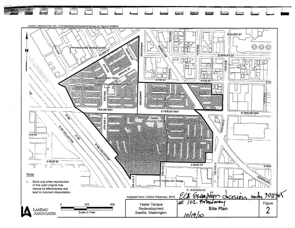
4 1.0 INTRODUCTION Landau Associates previously prepared the Earth Technical Report (Landau Associates, 2010) to support preparation of the Earth elements of the Draft Environmental Impact Statement (DEIS) for the proposed Yesler Terrace Redevelopment project located on the southern slope of First Hill in Seattle, Washington (see Figure 1). The Earth Technical Report is included as Appendix D to the DEIS. This Earth Technical Report Addendum provides additional information and analysis of the Preferred Alternative to support preparation of the Final Environmental Impact Statement (FEIS) for the project. These documents have been prepared to support the environmental review process for the Yesler Terrace Redevelopment project. Additional site-specific subsurface investigations and geotechnical engineering analyses would need to be performed as part of the specific design and permitting of infrastructure and buildings associated with future site redevelopment. 1.1 PROJECT DESCRIPTION The Seattle Housing Authority (SHA) is proposing the redevelopment of Yesler Terrace, a public housing community located near the intersection of Yesler Way and Broadway in Seattle s First Hill neighborhood. Yesler Terrace currently contains 561 units, housing approximately 1,200 residents. Redevelopment is proposed to create a mixed-income, mixed-use community that is intended to better serve existing and future residents. The project would include a mix of housing, office, commercial, and community service uses, as well as parks and open space, and street and utility infrastructure improvements. It is anticipated that the redevelopment of Yesler Terrace would take approximately 15 to 20 years to complete. 1.2 SITE DESCRIPTION The Yesler Terrace site is generally bordered by I-5 on the west, Alder Street and E Fir Street on the north, 14 th Avenue on the east, and S Main Street on the south (see Figures 2 and 3). For descriptive purposes, the Yesler Terrace site has been divided into sectors. Descriptions of the NW, NE, SW, SE, and East of Boren s are provided in the DEIS. The Preferred Alternative also includes three additional properties, located east of 12 th Avenue and east of the East of Boren, that make up the East of 12 th. The NW, NE, SW, and SE s that make up the Planned Action area are also referred to as the West of Boren s. The East of Boren and East of 12 th s are outside of the Planned Action area. The East of 12 th comprises three individual properties: the King County Records property, the Baldwin Apartments property, and the Urban League property (see Figures 2 and 3). The East of 12 th is bound by E Fir Street to the north, 12 th Avenue to the west, E Yesler Way to the south, and 14 th Avenue to the east. Yesler Terrace Redevelopment Earth Technical Report Addendum Final EIS April 11,
5 1.3 PREFERRED ALTERNATIVE The Preferred Alternative represents an assumed 5.47 million square feet of housingbased/mixed-use redevelopment built over the assumed 20-year horizon. Land uses under the Preferred Alternative are anticipated to include: 5,000 residential units, including 4,500 in the West of Boren s, 250 in the East of Boren, and 250 residential units in the East of 12 th 900,000 square feet of single-use office space (a portion of this could be hotel) Approximately 88,000 square feet of neighborhood commercial/retail space (including 9,000 square feet of neighborhood retail/office in the East of Boren and 4,000 square feet of neighborhood commercial in the East of 12 th ) Approximately 65,000 square feet of neighborhood service space (including the Yesler Community Center and Steam Plant) 6.4 acres of public open space (including the existing 1.4-acre Yesler Community Center parcel, and a 1.7-acre Common Park west of the Community Center) and 10.8 acres of semi-private open space 5,100 parking spaces within/under buildings. The intensity of development under the Preferred Alternative would be highest in the NW and lowest in the East of 12 th. It is assumed that four existing onsite buildings (the Steam Plant and the City-owned Yesler Community Center, Baldwin Apartments, and Urban League Building) would be retained. Street vacations and new street dedications are proposed to provide a more connected grid network internally and to/from the surrounding community. For purposes of the EIS analysis, certain assumptions have been made related to the number of possible mid- and high-rise buildings and the distribution of such buildings across the site; however, the specific number, height, location, and general design parameters of onsite buildings would be determined as part of the Proposed Actions. In the Preferred Alternative, two 22-story high-rise office buildings are assumed to be located in the NW adjacent to Alder Street to approximately match the adjacent height and density of the adjacent zoning at Harborview Hospital. It is assumed that housing would be composed of a combination of fiveto seven-story mid-rise buildings and ten 15- to 22-story high-rise buildings proportionally placed in each of the NW, NE, SE, and SW sectors to accommodate the lower density land use and maximize spacing between the high-rise buildings. No new low-rise buildings (four stories or less) are assumed in this alternative. In the Preferred Alternative, it is assumed that parking would be provided in below-grade structures under buildings, plazas, and open space. Typically, parking would be provided below individual buildings (with about 1 to 10 levels of underground parking), but in some cases parking could be combined and located below multiple buildings. It is assumed that substantial transportation infrastructure improvements would be made. The existing street grid would be reconfigured to enhance the connections to surrounding neighborhoods and provide an internal circulation loop of secondary rights-of-way that would connect all of the site sectors without the need to travel on primary rights-of-way. Yesler Terrace Redevelopment Earth Technical Report Addendum Final EIS April 11,
6 The southern portion of the alley north of Spruce Street between 9 th Avenue and Terry Avenue (the northern portion of the alley was previously vacated) would be vacated. In addition, the following road segments would be vacated under the Preferred Alternative (see Figure 4): Terry Avenue Spruce Street A portion of 8 th Avenue S between Yesler Way and Washington Street Service road around the Steam Plant (portion not within new 9 th Avenue alignment) S Washington Street from 10 th to 12 th Avenue S S Main Street west of 10 th Avenue S Stub of 9 th Avenue S south of S Main Street. The following streets would be dedicated as new rights-of-way under the Preferred Alternative (see Figure 5): E Fir Street would be dedicated from Broadway to 8 th Avenue S Washington Street would be dedicated from 8 th Avenue S to 10 th Avenue S 10 th Avenue S would be dedicated from S Washington Street to S Main Street Additional right-of-way adjacent to 10 h Avenue and 10 th Avenue S would be dedicated to widen the existing right-of-way Additional right-of-way adjacent to Yesler Way and E Yesler Way would be dedicated to widen the right-of-way. It is assumed that substantial utility infrastructure improvements would be made. Water, sewer, and natural gas mains would be installed or replaced as necessary. The permanent stormwater control system would be similar to DEIS Alternative 1. Green Stormwater Infrastructure facilities under the Preferred Alternative could include permeable pavement access roads, courtyards, and private sidewalks, green roofs, bioretention planters and swales; stormwater vaults/tanks serving individual parcels could be used when necessary. It is estimated that about 638,200 cubic yards (yd 3 ) of cut and about 41,000 yd 3 of fill would be associated with site grading and building construction activities for the Preferred Alternative (SvR Design Company, 2011). The existing steep slope/slide-prone areas along the southern portion of the SW would be regraded and stabilized as part of site redevelopment and building construction under the Preferred Alternative. 2.0 AFFECTED ENVIRONMENT This section summarizes the existing site conditions and affected earth environment at and in the vicinity of the Yesler Terrace site. 2.1 WEST OF BOREN AND EAST OF BOREN SECTORS Existing site conditions (including topography, geologic and groundwater conditions, and geologic hazards) for the West of Boren and East of Boren s are the same as those described in the DEIS. Yesler Terrace Redevelopment Earth Technical Report Addendum Final EIS April 11,
7 2.2 EAST OF 12 TH SECTOR The East of 12 th comprises three individual properties: the King County Records property, the Baldwin Apartments property, and the Urban League property (see Figures 2 and 3). The King County Records property is developed with two warehouse buildings, and is bound by E Fir Street to the north, 13 th Avenue to the east, E Yesler Way to the south, and by a parking lot, restaurants, and an automobile service station to the west. The Baldwin Apartments property is bound by E Fir Street to the north, the Urban League property to the east, residential development to the south, and 13 th Avenue to the west. The Urban League property is bound by E Fir Street to the north, 14 th Avenue to the east, E Yesler Way to the south, and residential development and the Baldwin Apartments property to the west. The existing buildings in the East of 12 th are wood frame or masonry construction and likely supported by shallow foundations Topography The topography in the East of 12 th slopes downward generally to the south and southeast with a maximum of about 10 feet (ft) of elevation change between E Fir Street and E Yesler Way Geology The general geology, surficial geology, and geologic units at the East of 12 th are the same as those described for the rest of the Yesler Terrace site in the DEIS Groundwater Groundwater conditions in the East of 12 th are generally the same as those described in the DEIS; however, groundwater perched in surficial fill and/or recessional outwash materials may be encountered from about 5 to 15 ft below ground surface due to the presence of relatively shallow glacial till in certain portions of the area Geologic Hazards The potential geologic hazards at the East of 12 th are generally the same as those described in the DEIS, except that no steep slope or landslide hazards are known to be present in the East of 12 h. Note that a small steep slope area is identified on City of Seattle Department of Planning and Development (DPD) Geographic Information System (GIS) maps on a portion of the offsite property located to the west-northwest of the King County Records property (see Figure 3-1 in Attachment 3 of the Earth Technical Report). However, a site reconnaissance confirmed that this is actually an area with a soil retaining structure and would not meet the definition of a steep slope area. Yesler Terrace Redevelopment Earth Technical Report Addendum Final EIS April 11,
8 3.0 IMPACTS This section describes the potential impacts of the Preferred Alternatives that are associated with the existing earth environment at the Yesler Terrace site. 3.1 WEST OF BOREN AND EAST OF BOREN SECTORS The potential geologic hazard impacts and construction impacts for the West of Boren and East of Boren s are the same as those described in the DEIS. The Preferred Alternative would require grading for construction of building foundations, roads, utilities, and parking structures in the West of Boren and East of Boren s. For purposes of this Preferred Alternative evaluation, a preliminary grading concept was formulated for these s, with the resulting cut and fill volume estimates as summarized in Table 1. Table GRADING ACTIVITIES FOR THE PREFERRED ALTERNATIVE (WEST OF BOREN AND EAST OF BOREN SECTORS) Grading Activity NW NE SE SW East of Boren TOTAL Cut (yd 3 ) 303,000 91,600 65, ,200 18, ,200 Fill (yd 3 ) 7,800 6,400 4,300 22, ,100 Source: SvR Design Company, Under the Preferred Alternative, new building construction and substantial site grading and infrastructure improvements would occur in the existing steep slope/slide-prone areas along the southern portion of the SW and SE s and in the area containing tiebacks for the northern wall of the Pacific Rim Center Building, similar to DEIS Alternatives 2 and 3. While there could be significant potential impacts on these steep slope/slide-prone areas and the existing drainage tunnels that would require substantial slope stabilization and drainage improvements, the mitigation measures described in the DEIS would address those potential impacts. 3.2 EAST OF 12 th SECTOR The potential geologic hazard impacts and construction impacts for the East of 12 th are generally the same as those described in the DEIS, except that no potential steep slope or landsliding impacts would be present in the East of 12 th. The Preferred Alternative would require grading for construction of building foundations, utilities, and parking structures in the East of 12 th. For purposes of this Preferred Alternative evaluation, a preliminary grading concept was formulated for this sector. It is estimated that approximately 24,000 yd 3 of cut and no fill would be required to redevelop this sector. The grading activities would occur on the King County Records property in order to develop underground parking. Specific grading plans for redevelopment would be developed as part of the future design and permit process. Yesler Terrace Redevelopment Earth Technical Report Addendum Final EIS April 11,
9 3.3 OPERATION IMPACTS No potential operation impacts that are associated with the existing earth environment at the Yesler Terrace site have been identified. 4.0 MITIGATION MEASURES This section describes the potential mitigation that would be evaluated and used as necessary and appropriate to address the earth-related impacts of site redevelopment under the Preferred Alternative. 4.1 WEST OF BOREN AND EAST OF BOREN SECTORS The potential mitigation measures associated with redevelopment of the West of Boren and East of Boren s under the Preferred Alternative are the same as those described in the DEIS. The mitigation measures described in the DEIS would address the potential impacts associated with new building construction and substantial site grading and infrastructure improvements in the existing steep slope/slide-prone areas along the southern portion of the SW and SE s. 4.2 EAST OF 12 th SECTOR The potential mitigation measures associated with redevelopment of the East of 12 th are generally the same as those described in the DEIS, except that no mitigation measures to address potential steep slope or landsliding impacts would be needed in the East of 12 th. 5.0 SIGNIFICANT UNAVOIDABLE ADVERSE IMPACTS With implementation of the mitigation measures summarized in the DEIS, no significant unavoidable adverse impacts are expected for the earth element of the Preferred Alternative. 6.0 UPDATE OF THE EIS ANALYSIS This section provides an update of the analysis of the earth element of the EIS. 6.1 STEEP SLOPE DEVELOPMENT VARIANCE APPROVAL As part of the environmental review process for the Yesler Terrace project, SHA submitted documentation (SHA, 2010) to the Seattle DPD to support a request for relief from the prohibition on steep slope development for the West of Boren based on the identified Environmental Critical Area (ECA) steep slopes having been created through previous legal grading activities. Seattle DPD subsequently granted SHA s request on October 19, 2010, and a copy of DPD s steep slope development decision is included in Attachment 1. Yesler Terrace Redevelopment Earth Technical Report Addendum Final EIS April 11,
10
11 9.0 REFERENCES Landau Associates Earth Technical Report, Yesler Terrace Redevelopment Project, Seattle, Washington. Prepared for CollinsWoerman. October 12. SHA Request for Relief from Prohibition on Steep Slope Development. DPD Project No Yesler Terrace Redevelopment Project, Seattle, Washington. Seattle Housing Authority. Submitted to City of Seattle Department of Planning and Development. October 4. SvR Design Company Memorandum: FEIS Earthwork Data Analysis, Yesler Terrace Development. Prepared for CollinsWoerman and Landau Associates. February 28. Yesler Terrace Redevelopment Earth Technical Report Addendum Final EIS April 11,
12 Kerry K ry Parkr Ward W Springs ParkP k Queen Anne Western Pier 70 Roy Elliott Broad 2nd Taylor Mercer 5th Seattle Elliott Bay Wall Regrade Parkr 1st 9th Denny Lake L Union Valley Denny y Parkr Waterfront a f Park Westlake Alaskan Fairview Marion Stewart Eastlake Olive Bellevue B l Placea e 5th Boren Broadway 10th Cascade Playgroundl Thomas Street t Park k Boren B Pike i e Pine P Park Tashkent Park Broadway Market Pacific Place First t Hill l Parkr Westlake W Park Victor Steinbrueck r k Park Freeway eway Park Yesler Klondike n k Gold o d Rush NHPKobe K e Terrace T Park Royal Brougham Airport Volunteer Park Reservoir Volunteer ParkP r Madison 12th Dearborn Volunteer ParkwayP John Bobby by Morris Reservoir Bobby o Morris M s Playfieldl i ld Dr Rizal Park James Project Location 90 Golf Jefferson Rainier Lewis Park Thomas 20th Cherry 23rd 24th Washington n Park Arboretum Union Judkins Playgroundl Thomas Pendleton Miller M r Playfieldi d Seattle - Vashon Harborview r i Parka k Spruce S e Street S e Park Pioneer P Square Park kcity t Hall l ParkP k Hing n Hay ParkP k International a i al Children l e Parkr Williams W l ia PlaceP McGilvra c i v a Place Spring S Street S Parkr Prenr is Frazier F a ParkP William i m Grose G o e ParkP k Plum l Tree Park Garfield Playfield l Gerber Park Powell P Barnet Park Madrona Playground d Madrona M o Park 30th Pratt P a Park Dr Blanche e Lavizzo Parkr Flo o Ware Parka k Frink i ParkP k 31st Lake Washington Leschi Park Mcgilvra Lake View i Park Peppis PlaygroundP r n Viretta V r Park k Madrona Briar i r Patch Alvin l Larkins ParkP k Lake WashingtonW Duwamish Waterway Marginal 99 1st 4th Holgate Airport 5 15th Viewpoint Park Beacon Stevens Placel e Colman PlaygroundP d 900 Bradner r Playground y 23rd Colman m Park Seattle S e Tennis Center MLK Jr r Memorial i Park Mcclellan Cheasty GreenbeltG Lake Park Lakeside Mt t Baker B Park Ridgeway Place c Y:\Projects\818003\MapDocs\040\Fig1 mxd 3/4/ Miles Data Source: ESRI 2008 Yesler Terrace Redevelopment Seattle, Washington Project Location Vicinity Map Everett Seattle Tacoma Spokane W a s h i n g t o n Figure 1
 \"Figure 2\" 3/4/2011 Harborview Medical Center Baldwin Apartments NW NE East of Boren King County Records and Archives Urban League SE East of 12th SW 10th AVE S 12th AVE S 9th AVE S Pacific")
13 LANDAU ASSOCIATES, NC. V:\818\003\ \GeoTech\Figure 2 Site Plan Geo.dwg (A) "Figure 2" 3/4/2011 Harborview Medical Center Baldwin Apartments NW NE East of Boren King County Records and Archives Urban League SE East of 12th SW 10th AVE S 12th AVE S 9th AVE S Pacific Rim Center S. JACKSON ST. Adapted from: Collins Woerman, Scale in Feet Yesler Terrace Redevelopment Seattle, Washington Site Plan Figure
14 10TH AVE S Y:\Projects\818003\MapDocs\050\053\Fig3 mxd 3/10/2011 NAD 1983 StatePlane Washington North FIPS 4601 Feet Harborview Medical Center 9TH AVE Steam Plant ALDER ST NW SPRUCE ST BROADWAY Boren Ave 10TH AVE NE E SPRUCE ST E FIR ST BOREN AVE 11TH AVE 12TH AVE East of Boren 14TH AVE Baldwin Apartments King County Records Property Urban League Property YESLER WAY E YESLER WAY 8TH AVE S Yesler Terrace Community Center SW SE BOREN AVE S 12TH AVE S East of 12th S MAIN ST S MAIN ST Pacific Rim Center Legend NW s Data Source: King County; Bing Maps Aerial Note 1. Black and white reproduction of this color original may reduce its effectiveness and lead to incorrect interpretation. 2. EOB = East of Boren Scale in Feet Yesler Terrace Redevelopment Seattle, Washington Aerial Photograph Site Plan Figure 3


15 LANDAU ASSOCIATES, NC. V:\818\003\ \GeoTech\Figure 4_5 dwg (A) "Figure 4" 3/10/2011 East of Boren East of 12th Adapted from: Collins Woerman, 2010 Yesler Terrace Redevelopment Seattle, Washington Preferred Alternative Right-of-Way Vacations Figure
 \"Figure 5\" 3/10/2011 East of")

16 LANDAU ASSOCIATES, NC. V:\818\003\ \GeoTech\Figure 4_5 dwg (A) "Figure 5" 3/10/2011 East of Boren East of 12th Adapted from: Collins Woerman, 2010 Yesler Terrace Redevelopment Seattle, Washington Preferred Alternative Right-of-Way Dedications Figure
17 ATTACHMENT 1 DPD Steep Slope Development Decision
18
19
20
21
22 ATTACHMENT 2 Summary of Groundwater Observations
23 Table 2-1 Yesler Terrace Redevelopment Project Summary of Groundwater Observations at Exploration Locations (As of March 3, 2011) Approximate Approximate Ground Depth to Water Exploration ID Elevation (ft) Water (ft) Elevation (ft) Date Note LAI /24/ /18/ /24/2010 ATD, perched LAI /30/ /24/ /30/2010 LAI /24/ /25/2010 ATD LAI /17/2010 GW not observed LAI /24/2010 ATD /30/2010 LAI /24/ /18/2010 ATD LAI /18/2010 GW not observed LAI /25/2010 ATD Notes: ATD - approximate water level observed at time of drilling. Refer to Attachment 1 of the Earth Technical Report for the exploration locations.
Description of Preferred Alternative
 Chapter 2 Description of Preferred Alternative 2.1 Introduction This chapter of the programmatic Sammamish Town Center Sub-area Plan Final EIS provides a more detailed description of the Preferred Alternative
UNIVERSITY OF WASHINGTON Mercer Hall Project, Terry/Lander Hall Project, and Development Capacity Re-allocation from Central to West Campus
 UNIVERSITY OF WASHINGTON Mercer Hall Project, Terry/Lander Hall Project, and Development Capacity Re-allocation from Central to West Campus EIS ADDENDUM UNIVERSITY OF WASHINGTON May 25, 2011 EIS Addendum
1.1 WATERFRONT SEATTLE
 1.1 WATERFRONT SEATTLE Over the past few years, the City of has been actively re-imagining the future of its Central Waterfront. The imminent replacement of the Elliott Bay Seawall and removal of the Alaskan
Appendix E Section 4(f) Evaluation
 Evaluation") Appendix E Section 4(f) Evaluation Appendix E Draft Section 4(f) Evaluation E.1 Introduction This appendix addresses a federal regulation known as Section 4(f), which protects parks, recreation areas,
Appendix E Section 4(f) Evaluation Appendix E Draft Section 4(f) Evaluation E.1 Introduction This appendix addresses a federal regulation known as Section 4(f), which protects parks, recreation areas,
Concept Evaluations 2 May 2009
 Concept Evaluations 2 May 2009 Evaluation Purpose The purpose of this evaluation is to gain feedback from the CRC and community on the ideas presented within the concepts and how the concepts relate to
APPENDIX C Discipline Report Errata Sheets. Final Environmental Impact Statement Alaskan Way, Promenade, and Overlook Walk
 APPENDIX C Discipline Report Errata Sheets Final Environmental Impact Statement Alaskan Way, Promenade, and Overlook Walk October 2016 Alaskan Way, Promenade, and Overlook Walk Final Environmental Impact
Stakeholder Advisory Group Level 2 Recommendations Snapshot
 Stakeholder Advisory Group Level 2 Recommendations Snapshot The following recommendation tables were completed with the West Seattle and Ballard Link Extensions Stakeholder Advisory Group (SAG) during
Phasing and Implementation
 Phasing and Implementation Adaptive Reuse and New Construction Opportunities The reuse of existing buildings at UW Tacoma S 21st St S 17th St Tacoma Ave is highly valued for maintaining the history, character,
West Seattle and Ballard Link Extensions. Early Scoping Information Report
 West Seattle and Ballard Link Extensions Early Scoping Information Report February 2018 1. Early Scoping 1.1 Introduction 1.1.1 West Seattle and Ballard Link Extensions Early Scoping: February 2, 2018
HEALTH SCIENCES BUILDING REDEVELOPMENT PROJECT
 INTRODUCTION In recent years, the University of Cincinnati (University) has demonstrated a commitment to identifying and implementing sustainable goals and objectives throughout University s Uptown Campuses.
East Corridor Final Environmental Impact Statement
 East Corridor Final Environmental Impact Statement Alternatives Considered Operating Plan The requirements for opening day operations versus year 2030 are based on ridership and operations. Opening day
Draft TISCORNIA ESTATE SPECIFIC PLAN/EIR
 Draft TISCORNIA ESTATE SPECIFIC PLAN/EIR Submitted CONTENTS 1. PLAN SUMMARY II. INTRODUCTION IX. SPECIFIC PLAN RELATIONSHIPS X. XI. List of Figures 1. Regional Location 2. Point Richmond Area 3. Planning
Level 1 Downstream Analysis
 Level 1 Downstream Analysis Newcastle Way Apartments Newcastle, Washington King County April 14, 2014 Revised July 10, 2014 Prepared by: Dean A. Furr, P.E. Reviewed by: Donald Scarberry, P.E. Coffman Engineering,
OP Council Resolution June 16, Planning and Development Services
 OP-08-01 Council Resolution June 16, 2008 Planning and Development Services Kingsgate Landing Outline Plan Table of Contents 1.0 Introduction 1 1.1 Purpose of Plan 1 1.2 Plan Area Location 1 1.3 Ownership
DEPARTURE FROM DESIGN STANDARDS DDS-586
 The Maryland-National Capital Park and Planning Commission Prince George s County Planning Department Development Review Division 301-952-3530 Note: Staff reports can be accessed at www.mncppc.org/pgco/planning/plan.htm.
City of Grande Prairie Development Services Department
 City of Grande Prairie Development Services Department ROYAL OAKS NORTH OUTLINE PLAN OP-07-03 NW 35-71-6 W6M May 7, 2007 Royal Oaks North Outline Plan TABLE OF CONTENTS 1.0 INTRODUCTION........ 3 1.1 Purpose
City of Grande Prairie Development Services Department KENNEDY DEVELOPMENTS LTD. OUTLINE PLAN OP-09-01
 City of Grande Prairie Development Services Department KENNEDY DEVELOPMENTS LTD. OUTLINE PLAN OP-09-01 July 27, 2009 TABLE OF CONTENTS 1.0 Introduction... 1 1.1 Plan Area Location & Context... 1 1.2 Ownership
4.8 LAND USE AND PLANNING
 4.8 LAND USE AND PLANNING 4.8.1 INTRODUCTION This section describes existing and planned land uses at the Hayward campus and analyzes the impact of implementation of the proposed Master Plan on land uses
DECISION CRITICAL AREAS ALTERATION AND DETERMINATION OF NONSIGNIFICANCE (DNS)
") DECISION CRITICAL AREAS ALTERATION AND DETERMINATION OF NONSIGNIFICANCE (DNS) Development Services Department 17301 133rd Avenue NE Woodinville, WA 98072 425-489-2754 www.ci.woodinville.wa.us Project Name:
DECISION CRITICAL AREAS ALTERATION AND DETERMINATION OF NONSIGNIFICANCE (DNS) Development Services Department 17301 133rd Avenue NE Woodinville, WA 98072 425-489-2754 www.ci.woodinville.wa.us Project Name:
Chapter 4 - Preparation of Stormwater Site Plans
 Chapter 4 - Preparation of Stormwater Site Plans The Stormwater Site Plan is the comprehensive report containing all of the technical information and analysis necessary for the City to evaluate a proposed
2.3 Housing Affected Environment 2009 SEIS. Current Conditions
 Discussion: After further planning efforts subsequent to issuance of the CMP-Seattle in 2003, the University determined that it is infeasible and cost prohibitive to renovate the existing Lander Hall and
Draft Master Plan for Franklin Park
 Draft Master Plan for Franklin Park Metro Parks Tacoma with SiteWorkshop November 2009 I. overview & background Process & History Master Plan Process The Master Plan is based on a community involvement
Appendix H Historic Resources Discipline Report. Draft Environmental Impact Statement Alaskan Way, Promenade, and Overlook Walk
 Appendix H Historic Resources Discipline Report Draft Environmental Impact Statement Alaskan Way, Promenade, and Overlook Walk May 2015 Alaskan Way, Promenade, and Overlook Walk Draft Environmental Impact
Visual and Aesthetic Resources
 Visual and Aesthetic Resources 7.1 INTRODUCTION This chapter evaluates the effects of the Modified Design on visual and aesthetic resources, in comparison to the effects of 2004 FEIS Design. The 2004 FEIS
Palisades Outline Plan
 NE ¼ 25 36 28 W4 Town of Penhold Approved August 13, 2012 Contents Figures & Tables... 2 Introduction... 1 Overview... 1 Purpose... 1 Development Area... 3 Ownership... 3 Topography... 3 Existing & Surrounding
Institutional Master Plan The Arnold Arboretum of Harvard University
 Institutional Master Plan The Arnold Arboretum of Harvard University Submitted to: Boston Redevelopment Authority One City Hall Square Boston, MA 02201 Submitted by: The Arnold Arboretum of Harvard University
East River Waterfront Esplanade and Piers New York, New York Draft Environmental Impact Statement
 East River Waterfront Esplanade and Piers New York, New York Draft Environmental Impact Statement October 12, 2006 CEQR No.: TO COME ULURP Nos.: TO COME Lead Agency: Lower Manhattan Development Corporation
Gold Line Bus Rapid Transit Transit Oriented Development (BRTOD) Helmo Station Area Plan
 Helmo Station Area Plan") Appendix F Gold Line Bus Rapid Transit Transit Oriented Development (BRTOD) Helmo Station Area Plan Introduction and Purpose of the Plan The Gold Line Bus Rapid Transit facility is an eleven-mile dedicated
Appendix F Gold Line Bus Rapid Transit Transit Oriented Development (BRTOD) Helmo Station Area Plan Introduction and Purpose of the Plan The Gold Line Bus Rapid Transit facility is an eleven-mile dedicated
New Partners for Smart Growth Conference February 5, 2010
 Dan Stroh, Planning Director City of Bellevue Planning and Community Development Bellevue, WA New Partners for Smart Growth Conference February 5, 2010 Summary of Project Long-range plan update for Bel-Red
SECOND AND UNIVERSITY SEATTLE, WASHINGTON
 SECOND AND UNIVERSITY SEATTLE, WASHINGTON Contents Overview 02 Vision 04 Access 06 Tower Details 08 Urban Village 18 The Neighborhood 22 Contact 25 The best ideas come from a place of uncertainty. Roll
SITING CONSIDERATIONS
 Bioretention: Siting and Applications Presentation Overview Siting Considerations Native Soil Characterization Lessons Leaned Feasibility & Performance Applications ALICE LANCASTER, PE alancaster@herrerainc.com
III. PROJECT DESCRIPTION
 III. PROJECT DESCRIPTION A. PROJECT LOCATION Regional Setting The project site is located in the southeast quadrant of the City of Chico in Butte County, California and is comprised of four parcels totaling
112th Avenue Light Rail Options Concept Design Report JUNE 2010 PREPARED FOR PREPARED BY TBG PGH
 112th Avenue Light Rail Options Concept Design Report JUNE 2010 PREPARED FOR PREPARED BY TBG060310124909PGH C ontents Introduction 1 Project Overview 1 Public Involvement and Technical Coordination 4 Description
Transportation Improvements
 Transportation Improvements 0 0 Volume II of the Final EIS for the DHS Headquarters consolidation at St. Elizabeths includes analysis to transportation improvements for the DHS Headquarters Consolidation
Appendix G Public Services and Utilities Discipline Report. Draft Environmental Impact Statement Alaskan Way, Promenade, and Overlook Walk
 Appendix G Public Services and Utilities Discipline Report Draft Environmental Impact Statement Alaskan Way, Promenade, and Overlook Walk May 2015 Alaskan Way, Promenade, and Overlook Walk Draft Environmental
Northern Branch Corridor SDEIS March 2017
 Northern Branch Corridor SDEIS March 2017 15. 15.1. Chapter Overview 15.1.1. Introduction This chapter discusses changes to the Preferred Alternative resulting in the potential for project improvements
Planning and Design: Applied LID Techniques Redevelopments, Housing, Mixed Use, Infrastructure
 Civil Engineering Landscape Architecture Environmental Restoration Planning Planning and Design: Applied LID Techniques Redevelopments, Housing, Mixed Use, Infrastructure Peg Staeheli, ASLA, LEED AP March
Yesler Terrace Explorations of Ideas 11 March 2009
 Yesler Terrace Explorations of Ideas 11 March 2009 Exploration of Ideas for Yesler Terrace Where are we in the process? Testing the Yesler Terrace Planning Program 1) How does the new Yesler Terrace feel?
SYSTEM EXPANSION. Sound Transit system expansion will:
 SYSTEM EXPANSION Sound Transit system expansion will: Expand Sounder south line capacity and service, including longer trains (to accommodate 40 percent more passengers) and the potential for more daily
BEACON HILL INTERNATIONAL SCHOOL
 CONTENTS Stormwater in the Schoolyard Lesson 3 BEACON HILL INTERNATIONAL SCHOOL Teacher Guide Local Stormwater Systems Lesson 5 Stormwater in Our Community Lesson 6 How to Use This Guide This guide supports
2.0 Hi s t o r y & Existing Co n d i t i o n s
 2.0 Hi s t o r y & Existing Co n d i t i o n s 2.1 Plan Area History The Lincoln East Specific Plan (Specific Plan) area is a significant part of the history of Sutter County. A 48,000 acre land grant
Lynnwood Link Extension
 Lynnwood Link Extension Moving forward together WELCOME /BIENVENIDO / / / OVERVIEW The Lynnwood Link Extension is a key part of Sound Transit s mass transit system expansion approved by voters. Targeted
6.1. INTRODUCTION AND SUMMARY OF FINDINGS
 Chapter 6: Stormwater Management 6.1. INTRODUCTION AND SUMMARY OF FINDINGS A Stormwater Pollution Prevention Plan (SWPPP) has been prepared for the Proposed Project in accordance with the requirements
5.2 LAND USE AND ZONING
 5.2 LAND USE AND ZONING This section describes the land use and zoning of the project site and surrounding area, followed by an analysis of the potential for incompatibility or adverse impact on prevailing
S o u t h C e n t r a l O u t l i n e P l a n. Leduc Business Park. North Leduc Industrial Area Structure Plan C it y of Led u c.
 Leduc Business Park North Leduc Industrial Area Structure Plan C it y of Led u c Prepared for Farm Air Properties Inc. January, 2007 Table of Contents Page Number 1.0 Purpose of Plan and Definition of
BALLARD TO DOWNTOWN SEATTLE
 TRANSIT EXPANSION STUDY BALLARD TO DOWNTOWN SEATTLE 05/30/2014 FINAL FINAL REPORT This page intentionally left blank Table of Contents Executive Summary... 1 1 Introduction... 1 2 Previous Studies and
12 January 12, 2011 Public Hearing APPLICANT: TAILWIND DEVELOPMENT GROUP,LLC PROPERTY OWNER: CITY OF VIRGINIA BEACH
 12 January 12, 2011 Public Hearing APPLICANT: TAILWIND DEVELOPMENT GROUP,LLC PROPERTY OWNER: CITY OF VIRGINIA BEACH STAFF PLANNER: Faith Christie REQUEST: Conditional Change of Zoning (from PD-H1 Planned
City of Lafayette Study Session Staff Report Design Review Commission
 ++ City of Lafayette Study Session Staff Report Design Review Commission Meeting Date: January 08, 2018 Staff: Subject: Chris Juram, Planning Technician SS12-17 Miramar Homebuilders, R-20 Zoning: Request
A. INTRODUCTION B. PROJECT LOCATION
 Chapter 1: Project Description A. INTRODUCTION The Lower Manhattan Development Corporation (LMDC), a subsidiary of the New York State Urban Development Corporation, doing business as the Empire State Development
Seattle City Council Central Staff - Memorandum
 Seattle City Council Central Staff - Memorandum Date: June 2, 2016 To: From: Subject: Councilmember Rob Johnson, Chair Councilmembers Mike O Brien and Lisa Herbold, Members Planning, Land Use and Zoning
Welcome! Agenda. South Downtown
 Welcome! Agenda 4:00 Open House 5:00 Presentation Welcome Subarea Plan Overview Existing Studies Next steps: Scoping 6:00 Questions and Answers 6:30 Open House continues Project background and purpose
Environmental Assessment. Appendix E Visual And Aesthetic Conditions Technical Report
 Environmental Assessment Appendix E Visual And Aesthetic Conditions Technical Report Visual & Aesthetic Conditions Kansas City Streetcar Main Street Extension December 20, 2018 02 Contents 1. Introduction...
Site Analysis Parks and Environment Open/green Space, Vegetation, Microclimate, Drainage and Soils
 Site Analysis Larc 503: Community Design Studio Winter 09 Prof. Jeff Hou 1 Site Analysis Parks and Environment Open/green Space, Vegetation, Microclimate, Drainage and Soils Jordan West Monez The is located
3.0 PROJECT DESCRIPTION
 3.0 PROJECT DESCRIPTION 3.1 BACKGROUND Under California law (Government Code Section 65300 et seq.), every city and county is required to have a general plan. The general plan is to be comprehensive and
Appendix E: Illustrative Green Infrastructure Examples
 Appendix E: Illustrative Green Infrastructure Examples Integrating LID into San Francisco s Urban Landscape Figure E. High-density Residential Figure E. Low-density Residential Figure E. Mixed Use 7 Figure
RESOLUTION NO. R Refining the route, profile and stations for the Downtown Redmond Link Extension
 RESOLUTION NO. R2018-32 Refining the route, profile and stations for the Downtown Redmond Link Extension MEETING: DATE: TYPE OF ACTION: STAFF CONTACT: Capital Committee Board PROPOSED ACTION 09/13/2018
Alaskan Way, Promenade, and Overlook Walk
 Draft Environmental Impact Statement Executive Summary Alaskan Way, Promenade, and Overlook Walk Prepared for Seattle Department of Transportation Seattle, Washington June 2015 Americans with Disabilities
Engineering Department R.H. Thomson Freeway Records,
 Engineering Department R.H. Thomson Freeway Records, 1958-1977 Overview of the Collection Creator Seattle (Wash.). Engineering Dept. Title Engineering Department R.H. Thomson Freeway Records Dates 1958-1977
NOTICE OF PREPARATION OF A DRAFT ENVIRONMENTAL IMPACT REPORT
 NOTICE OF PREPARATION OF A DRAFT ENVIRONMENTAL IMPACT REPORT TO: SUBJECT: Interested Parties Notice of Preparation of a Draft Environmental Impact Report for the Marywood Residential Development project.
APPENDIX D: Visual and Aesthetic Conditions for NCCU Station Refinement. Durham-Orange Light Rail Transit Project
 APPENDIX D: Visual and Aesthetic Conditions for NCCU Station Refinement Durham-Orange Light Rail Transit Project October 2016 1. Introduction The Combined FEIS/ROD summarizes the effects of the D-O LRT
C ity of Grande Prairie Development Services Department
 C ity of Grande Prairie Development Services Department FAIRWAY DEVELOPMENT OUTLINE PLAN OP 08 09 Approved April 6, 2009 Prepared by: Focus Corporation Table of Contents 1.0. Introduction 2 3 1.1. Plan
Alaskan Way, Promenade, and Overlook Walk Final EIS Appendix D - Supplemental Draft EIS Comments and Responses October 2016.
 B-001-001 The use of Columbia Street for two-way transit was a decision made by King County Metro as part of its Southwest Transit Pathway evaluation. This project is separate from AWPOW. B-001-002 Modeling
EXECUTIVE SUMMARY. Final Environmental Impact Statement Alaskan Way, Promenade, and Overlook Walk
 EXECUTIVE SUMMARY Final Environmental Impact Statement Alaskan Way, Promenade, and Overlook Walk October 2016 Final Environmental Impact Statement Executive Summary Alaskan Way, Promenade, and Overlook
B. ROLE OF THE EIS IN THE APPROVALS PROCESS
 Chapter 2: Methodology A. INTRODUCTION This chapter describes the Environmental Impact Statement (EIS) and its role in the approval process for the East River Esplanade and Piers Project (the Proposed
Appendix K Vegetation and Wildlife Discipline Report. Draft Environmental Impact Statement Alaskan Way, Promenade, and Overlook Walk
 Appendix K Vegetation and Wildlife Discipline Report Draft Environmental Impact Statement Alaskan Way, Promenade, and Overlook Walk May 2015 Alaskan Way, Promenade, and Overlook Walk Draft Environmental
Erik Rundell, Project Manager
 Erik Rundell, Project Manager M.U.R.P., Portland State University Certificate, Commercial Real Estate, University of Washington Graduate Certificate, GIS, University of Wisconsin-Madison B.A. Geography,
Drainage Report. For: Owner/Developer:
 Drainage Report For: My Place Hotel Lot 6, Charles Ritz Subdivision Overland Park, KS Owner/Developer: Overland Park Holdings, LLC Matt Eller 104 Campus Drive, Suite 202 Huxley, IA 50124 Civil Engineer:
Butchers Hill. Greening Feasibility FINAL REPORT MAY 2009 N PORT ST N WOLFE ST S MADEIRA ST. Submitted To: Submitted By:
 S WOLFE ST N CASTLE ST N WASHINGTON ST S WASHINGTON ST S CHAPEL ST S DURHAM ST S DUNCAN ST N MADEIRA ST N MONTFORD AVE Butchers Hill Greening Feasibility N DUNCAN ST MULLIKIN ST N PORT ST N WOLFE ST E
CITY OF CYPRESS 5275 Orange Avenue Cypress, California (714) DESIGN REVIEW COMMITTEE PERMIT PROCESS
 DESIGN REVIEW COMMITTEE PERMIT PROCESS") CITY OF CYPRESS 5275 Orange Avenue Cypress, California 90630 (714) 229-6720 DESIGN REVIEW COMMITTEE PERMIT PROCESS 1. Discuss project with Planning staff to determine zoning regulations, any unusual characteristics
CITY OF CYPRESS 5275 Orange Avenue Cypress, California 90630 (714) 229-6720 DESIGN REVIEW COMMITTEE PERMIT PROCESS 1. Discuss project with Planning staff to determine zoning regulations, any unusual characteristics
This Review Is Divided Into Two Phases:
 Semiahmoo Town Centre Review The purpose of this review: To review the Semiahmoo Town Centre Concept Plan, originally approved in 1993, to ensure that this centre will continue to serve the needs of South
burlington mobility hubs study Downtown Burlington Mobility Hub
 burlington mobility hubs study Downtown Burlington Mobility Hub Draft Precinct Plan Workbook PIC #3, September 7, 2017 downtown mobility hub objectives City staff and their consultants are proposing an
NORTH BETHANY ELEMENTARY SCHOOL SITE ASSESSMENT
 NORTH BETHANY ELEMENTARY SCHOOL SITE ASSESSMENT Prepared for: Prepared by: October 10, 2014 Page 2 Introduction and Purpose This report provides an assessment of two potential sites for a new elementary
General Location Annex, Rezone & Preliminary Plat Lansdowne Addition, Unit Three
 NEWFOUNDLAND I-5 Agricultural District Subject Site SUNDANCE ANDERSON Single Family Residential CHRISTY PUD Agricultural District Highway Business General Location Annex, Rezone & Preliminary Plat Lansdowne
Notice of Preparation of an Environmental Impact Report and Scoping Meeting for the Canyon Lane Roadway Improvements Development Project
 of an Environmental Impact Report and Scoping Meeting for the As the Lead Agency, the County of San Mateo (County) will prepare an Environmental Impact Report (EIR) for the (project), and would like your
APPENDIX A SIMPLIFIED APPROACH TO STORMWATER MANAGEMENT FOR SMALL PROJECTS. In West Sadsbury Township, Chester County, Pennsylvania
 APPENDIX A SIMPLIFIED APPROACH TO STORMWATER MANAGEMENT FOR SMALL PROJECTS In West Sadsbury Township, Chester County, Pennsylvania TABLE OF CONTENTS I. Introduction 3 II. Importance of Stormwater Management
Northern Branch Corridor SDEIS March 2017
 14. Water Quality 14.1. Chapter Overview 14.1.1. Introduction This section discusses changes to the potential for activities associated with the development and operation of the Preferred Alternative to
Review of Opportunity Area C Draft Comprehensive Plan and Draft BOS Follow-On Motions. Special Working Group Meeting March 4, 2015
 Review of Opportunity Area C Draft Comprehensive Plan and Draft BOS Follow-On Motions Special Working Group Meeting March 4, 2015 The slides that follow identify where the draft Comprehensive Plan has
SITING CONSIDERATIONS
 Bioretention: Siting and Applications Presentation Overview Siting Considerations Native Soil Characterization Lessons Leaned Feasibility & Performance Applications ALICE LANCASTER, PE alancaster@herrerainc.com
City of Cornwall Municipal Class Environmental Assessment. Proposed Improvement and Extension of Lemay Street
 Welcome City of Cornwall Municipal Class Environmental Assessment Proposed Improvement and Extension of Lemay Street Redevelopment and Design of the Municipal Works Yard Public Information Centre #1 Thursday,
3.0 Cumulative Scenario and Methodology. 3.0 Cumulative Scenario and Methodology
 3.0 Cumulative Scenario and Methodology Under the CEQA Guidelines, a cumulative impact consists of an impact which is created as a result of the combination of the project evaluated in the environmental
Riverside County Flood Control and Water Conservation District LAKELAND VILLAGE MDP LINE H, STAGE 1
 Riverside Flood Control and Water Conservation District Riverside, California LAKELAND VILLAGE MDP LINE H, STAGE 1 CEQA ADDENDUM TO THE FINAL PROGRAM ENVIRONMENTAL IMPACT REPORT FOR THE LAKELAND VILLAGE
B. DESCRIPTION OF THE PROPOSED ACTION
 Executive Summary A. INTRODUCTION Metro-North Commuter Railroad Company ( Metro-North or the Project Sponsor ) is proposing the construction of a new, expanded parking garage at 50 Haarlem Avenue (formerly
Note: Staff reports can be accessed at Zone: I-3. Tier:
 The Maryland-National Capital Park and Planning Commission Prince George s County Planning Department Development Review Division 301-952-3530 Note: Staff reports can be accessed at www.mncppc.org/pgco/planning/plan.htm.
City of Elmhurst. City of Elmhurst. Storm Sewer System Workshop November 22, 2010
 City of Elmhurst City of Elmhurst Storm Sewer System Workshop November 22, 2010 1 City of Elmhurst Watershed divide (green dashed line) through Elmhurst Area east of divide drains to Addison Creek Area
SECTION 4(f) DE MINIMIS DOCUMENTATION
 DE MINIMIS DOCUMENTATION") SECTION 4(f) DE MINIMIS DOCUMENTATION Illinois Route 60/83 IL 176 to the intersection of IL 60 (Townline Road) Lake County P-91-084-07 Mundelein Park and Recreation District Project Limit SECTION 4(f)
SECTION 4(f) DE MINIMIS DOCUMENTATION Illinois Route 60/83 IL 176 to the intersection of IL 60 (Townline Road) Lake County P-91-084-07 Mundelein Park and Recreation District Project Limit SECTION 4(f)
Bylaw C-1186 Adopted November 5, Planning and Development Services
 Bylaw C-1186 Adopted November 5, 2007 Planning and Development Services CITY OF GRANDE PRAIRIE OFFICE CONSOLIDATION BYLAW C-1186 A Bylaw to adopt the Westgate Area Structure Plan (As Amended by Bylaw C-1186-1,
RZC Public View Corridors and Gateways
 RZC 21.42 Public View Corridors and Gateways 21.42.010 Purpose 21.42.020 Scope and Authority 21.42.030 Administration 21.42.040 Gateways Design 21.42.050 Unidentified Public Views 21.42.060 Identification
ENVIRONMENTAL INITIAL STUDY BERKELEY CITYWIDE POOLS MASTER PLAN
 ENVIRONMENTAL INITIAL STUDY FOR THE BERKELEY CITYWIDE POOLS MASTER PLAN CITY OF BERKELEY PARKS RECREATION AND WATERFRONT DEPARTMENT SEPTEMBER 1, 2009 ENVIRONMENTAL INITIAL STUDY BERKELEY CITYWIDE POOLS
Village of Forest Park. July 27, Sewer Separation Evaluation
 Village of Forest Park July 27, 2015 Sewer Separation Evaluation Presentation Overview Study Background Historic Nature of Forest Park Drainage Scale of Flooding Problem Forest Park Sewer System Background
FUTURE LAND USE ELEMENT
 FUTURE LAND USE ELEMENT GOAL I: To create and sustain a great place to live, play, and prosper Objective 1: The City of Ocala shall incorporate the principles and strategies of the Ocala 2035 Vision into
Planning Districts INTRODUCTION
 INTRODUCTION To facilitate detailed examination of development prospects for all areas of the community, Delano has been divided into 14 planning districts. The location of these planning districts is
City of Tacoma Planning and Development Services
 Agenda Item E-1 City of Tacoma Planning and Development Services To: Planning Commission From: Elliott Barnett, Planning Services Division Subject: Tacoma Mall Regional Center Subarea Plan and EIS Meeting
CenterPointe at Grantville Master Plan
 CenterPointe at Grantville Master Plan Presented By: Sherman D. Harmer, Jr. Michael R. Dunham Jacob D. Schwartz Marco A. Cabrera Urban Housing Partners (619) 325-0444 620 First Ave. San Diego CA 92101
II. PROJECT DESCRIPTION
 II. PROJECT DESCRIPTION A. PROJECT APPLICANT The project applicant is the J.H. Snyder Company located at 5757 Wilshire Boulevard, Penthouse 20, in Los Angeles, CA 90036. B. PROJECT LOCATION The project
RESIDENTIAL PLANNED UNIT DEVELOPMENT / SUBDIVISION AND REZONING CONCEPT AND DEVELOPMENT STAGE PLAN SUBMITTAL NARRATIVE
 RESIDENTIAL PLANNED UNIT DEVELOPMENT / SUBDIVISION AND REZONING CONCEPT AND DEVELOPMENT STAGE PLAN SUBMITTAL NARRATIVE DEVELOPMENT TEAM DONEGAL SOUTH Maple Grove, Minnesota March 27, 2017 Applicant/Developer/Builder:
22a. Existing Condition. 22b. Simulation of NE 20th Street Alternative (D3)
") Appendix F4.5 Visual Consistency and Key Observation Point Analyses EXHIBIT F4.5-22 Key Observation Point 22 (looking east along NE 20th Street) 22a. Existing Condition 22b. Simulation of NE 20th Street
Appendix F4.5 Visual Consistency and Key Observation Point Analyses EXHIBIT F4.5-22 Key Observation Point 22 (looking east along NE 20th Street) 22a. Existing Condition 22b. Simulation of NE 20th Street
2. Analysis. DRAFT Gerald Richards & Pleasantview Park Master Plan
 DRAFT Gerald Richards & Pleasantview Park Master Plan 19 Historic Features According to the National Register of Historic Places and the National Historic Landmarks Program, there is nothing of national
West Broadway Transit Study Initial Screening of Alternatives Memo
 West Broadway Transit Study Initial Screening of Alternatives Memo 5/22/2015 Prepared by the SRF Consulting Group Team for Table of Contents Purpose... 1 Methodology... 1 Screening... 5 Screening Criteria...
Can Urban Redevelopment Restore Aquatic Resources
 Can Urban Redevelopment Restore Aquatic Resources with Standards for Stormwater Retention and Landscape Performance? Rebecca C. Stack District of Columbia Department of the Environment Industry, Agriculture,
Illustrative Campus Plan with Proposed Development
 Illustrative Campus Plan with Proposed Development Approved Compiled Plan January 2003 Figure IV-52 89 The supportive relationship and interaction between the campus and the surrounding community is an