HILLSBORO COMPREHENSIVE PLAN
|
|
|
- Melissa Skinner
- 5 years ago
- Views:
Transcription
1 HILLSBORO COMPREHENSIVE PLAN Table of Contents Ordinane No *****CLICK ON BLUE SECTION NUMBERS BELOW TO CONNECT TO SPECIFIC SECTIONS***** HILLSBORO COMPREHENSIVE PLAN TABLE OF CONTENTS Setion 1. Citizen Involvement (I) Goals (II) Definitions (III) Plan Revision and Major Plan Amendments (IV) Minor Plan Amendments (A) Minor Plan Amendments: Plan Text (B) Minor Plan Amendments: Plan Map (C) Minor Plan Amendment - General Proedures (V) Community Plans, Publi Faility Plans and Funtional Plans (VI) Plans Available for Publi Review (VII) Continual Review Proess (VIII) Communiation (IX) Feedbak Mehanism (X) Finanial Support (XI) Seletion Proess (XII) Ongoing Citizen Partiipation Program Setion 2. Urbanization (I) Goal (II) Definitions (A) Hillsboro Planning Area (B) Area of Interest (III) Poliies (A) Urbanization (B) Land Use Designations (C) Land Use Implementation Measures (D) Mutually Supportive Implementation Measures (E) Intergovernmental Coordination (F) Annexation and the Area of Interest (G) Comprehensive and Zoning of Annexed Properties (H) Servie Distrits (IV) Implementation Measures (A) Urban Development i
2 HILLSBORO COMPREHENSIVE PLAN Table of Contents Ordinane No *****CLICK ON BLUE SECTION NUMBERS BELOW TO CONNECT TO SPECIFIC SECTIONS***** 1. Urban Servies Neessary for Development 2. Sewage Trunk Lines 3. Publi Streets 4. Essential Servies 5. Infill 6. Station Community Planning Areas (B) Joint Capital Improvements (C) Floodplain Regulations (D) Review of Compliane with USA s Chapter 3 (E) Review of Comprehensive Plan Changes (F) Major or Minor Plan Change Determination (G) Annexation in the Hillsboro Planning Area (H) Joint Capital Improvements (I) New Development at Maximum Densities (J) Land Uses Identified on the Comprehensive Plan Map (K) Speial Industrial Distrit (SID) Overlay Zone (L) Title 4 Major Retail Use Restrition Overlay Map (M) Land Use Map (N) Amendments to the Urban Planning Area Agreement Setion 3. Housing (I) Goal (II) Definitions (III) Poliies (A) Buildable Land (B) Variety of Housing (C) Constrution (D) Various Types, Pries, Rents (E) Lots less than 7,000 Square Feet (F) Low Inome Housing (G) Manufatured Homes (H) Maintenane and Rehabilitation (I) Mixed Use - Commerial/Residential (J) Mid-Rise Housing (K) Senior Housing (L) Infrastruture in Residential Areas (M) Open spae (N) Density (O) Inompatible Uses (P) Nonresidential Publi and Quasi-publi Uses ii
3 HILLSBORO COMPREHENSIVE PLAN Table of Contents Ordinane No *****CLICK ON BLUE SECTION NUMBERS BELOW TO CONNECT TO SPECIFIC SECTIONS***** (IV) (Q) New and Innovative Design Tehniques (R) Redevelopment and Inreased Density (S) Inentives for Ahieving the Housing Goals (T) Revisions based upon housing needs and projetions (U) Flexible Implementation Measures for Variety of Housing Types. (V) Maximum and Minimum Residential Densities (W) Density and Donated Land for Publi Failities (X) Loal Commerial Conveniene Ativities (Y) Residential Density Developed within the Range Designated Implementation Measures (A) Planned Unit Development (C) Manufatured Home Parks (B) Deleted (D) Manufatured Homes Permitted in Single Family Zones (E) Duplex Units (G) Variable Lot Sizes (H) Elderly Housing (I) Intergovernmental Cooperation (J) Development Review Hearings (K) Floodplain Regulation (L) Subdivision and Major and Minor Land Partition Ordinane (M) Monitoring of Residential Development Densities (N) Preservation of Residential Density Setion 4. Agriultural Lands (I) Goal (II) Poliies (A) Farm Uses (B) Preservation of Agriultural Land outside the Urban Growth Boundary (C) Hortiultural Uses of Agriultural Lands (III) Implementation Measures (A) Agriultural Land Conversion: Expansion of the Urban Growth Boundary (B) Additional Implementation Measures: Open Spae, Seni and Historial Sites and Rereation Elements Setion 5. Forest Lands (I) Goal iii
4 HILLSBORO COMPREHENSIVE PLAN Table of Contents Ordinane No *****CLICK ON BLUE SECTION NUMBERS BELOW TO CONNECT TO SPECIFIC SECTIONS***** (II) (III) (IV) Definitions Poliies (A) Retention of Trees (B) Planting of Trees (C) Woods Lots for Parks and Open Spae Implementation Measures (A) Preservation and Planting of Trees (B) Additional Implementation Measures Following Data Gathering on: Open Spae, Seni and Historial Sites and Rereation Elements Setion 6. Open Spae, Seni and Historial Sites (I) Goals (II) Definitions (III) Poliies (A) Open Spae (B) Floodplain (C) Cultural Resoure (D) Green Corridor (IV) Implementation Measures Setion 7. Air, Water and Land Resoure Quality (I) Goal (II) Definitions (III) Poliies (IV) Implementation Measures Setion 8. Natural Disasters and Hazards (I) Goal (II) Definitions (III) Poliies (IV) Implementation Measures Setion 9. Rereation (I) Goal (II) Poliies (III) Implementation Measures iv
5 HILLSBORO COMPREHENSIVE PLAN Table of Contents Ordinane No *****CLICK ON BLUE SECTION NUMBERS BELOW TO CONNECT TO SPECIFIC SECTIONS***** Setion 10. Eonomy (I) Goals (II) Definitions (III) Poliies (A) Commerial Land Use (B) Industrial Land Use (IV) Implementation Measures Setion 11. Energy (I) Goal (II) Poliies (III) Implementation Measures Setion 12. Publi Failities and Servies (I) Goals (II) Definitions (III) Poliies (IV) (Deleted) (V) Implementation Measures (A) Coordination of Servies (B) Transportation (C) Water System (D) Sanitary Sewer (E) Storm Drainage (F) General Government (G) Polie Servies (H) Fire Protetion (I) Library Failities (J) Shools (K) Parks and Rereation (L) (Deleted) (M) (Deleted) (N) (Deleted) (VI) Publi Failities Plan Publi Faility Plan Capital Improvement List (20-Year CIP Projets) Setion 13. Transportation (I) Goal v
6 HILLSBORO COMPREHENSIVE PLAN Table of Contents Ordinane No *****CLICK ON BLUE SECTION NUMBERS BELOW TO CONNECT TO SPECIFIC SECTIONS***** (II) (III) (IV) (V) (VI) (VII) Definitions Poliies (A) Safety (B) Multi-modal (C) Trip Redution (D) Performane (E) Goods Movement (F) Livability (G) Aessibility (H) Airport (I) Alternative Transportation (J) Hillsboro Airport (Deleted) (Deleted) (Deleted) Implementation Measures Setion 14. Comprehensive Plan Maps (I) Maps, Type and Purpose (A) Transportation Maps (B) Land Use Maps Setion 15. Station Community Planning Areas (I) Goal (II) General Station Community Planning Area Poliies (III) Downtown SCPA Poliies (IV) Hawthorn Farm/Fair Complex SCPA Polies (V) Oreno SCPA Poliies (VI) Quatama/185 th SCPA Poliies Setion 16. Severability (I) Severability Setion 17. th NE 28 Avenue/East Main Street Plan Area (I) Goal (II) General Poliies (III) Land Use Poliies (IV) Urban Design Poliies vi
7 HILLSBORO COMPREHENSIVE PLAN Table of Contents Ordinane No *****CLICK ON BLUE SECTION NUMBERS BELOW TO CONNECT TO SPECIFIC SECTIONS***** (V) (VI) Transportation Poliies Implementation Setion 18. Hillsboro Tanasbourne Community Plan (I) Goals (II) Poliies (III) Implementation Measures Setion 19. Tanasbourne Town Center Community Plan City of Hillsboro, Tanasbourne Town Center Plan Setion 20. Shute Road Industrial Site (I) Goals (II) Poliies (III) Implementation Measures Setion 21. Transportation System Plan (TSP) City of Hillsboro, Transportation System Plan (TSP) Setion 22. With Hazel Village Community Plan (I) Goals (II) General Development Poliies (III) Implementation Measures Setion 23. City of Hillsboro, With Hazel Village Community Plan City of Hillsboro, With Hazel Village Community Plan vii
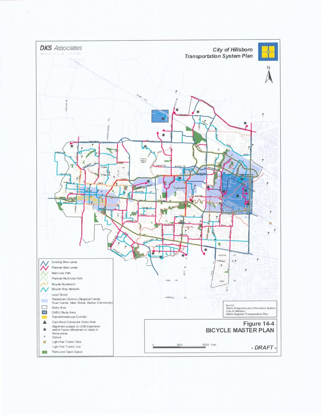
8 HILLSBORO COMPREHENSIVE PLAN Table of Contents Ordinane No *****CLICK ON BLUE SECTION NUMBERS BELOW TO CONNECT TO SPECIFIC SECTIONS***** Figure Number Figure 1-1 Figure 13-1 Figure 13-2 Figure 13-3 Figure 13-4 Figure 13-5 Figure 13-6 Figure 14-1 Figure 14-1a Figure 14-2 Figure 14-3 Figure 14-4 Figure 14-5 Figure 14-6 Figure 14-7 Figure 14-8 Figure 14-9 Figure Figure Figure 17-1 Figure 17-2 Figure 18-1 Figure 20-1 Figure 20-2 Figure 20-3 Figure 20-4 Figure 20-5 Figure 20-6 Figure 22-1 City Planning Subareas Alley, Cul-de-sa and Loal Residential Street Sample Street Cross Setions Required ROW Width Neighborhood Sample Street Cross Setions Required ROW Width Colletor Sample Street Cross Setions Required ROW Width Arterial Sample Street Cross Setions Required ROW Width Street Improvement Plan Commerial/Industrial Sample Street Cross Setions Required ROW Width Hillsboro Funtional Classifiation Plan Future Streets Where ROW is Planned for More Than Two Lanes Street Improvement Plan Truk/Freight Route Master Plan Biyle Master Plan Transit Master Plan Hillsboro Traffi Signal Master Plan Pedestrian Master Plan Park-and-Ride Sites Rail Routes Major Pipeline Routes Hillsboro 2040 Growth Conept Boundaries NE 28 th Avenue East Main Street Plan Area NE 28 th Avenue East Main Street Plan Area Tanasbourne Town Center Plan Shute Road Preferred Design Conept A Shute Road Alternative Design Conept B Shute Road Transportation Plan Conept A Shute Road Transportation Plan Conept B Shute Road Publi Failities & Servies Conept A Shute Road Publi Failities & Servies Conept B With Hazel Village Community Plan Map viii
 PETER BOSCOW 3. CENTRAL (Downtown/Jakson Bottom/Eastwood/Henry Area) 1.")
9 Dairy MKay Dairy MKay Popp Reservoir M Kay W VERNE MKINNEY Tualatin reek C PAUL L PATTERSON GLENCOE Jakson Slough River Ponds EVERGREEN Waible Pond Waible Res. 2. NORTHWEST (Glenoe/Jakson Shool/Sunrise Area) PETER BOSCOW 3. CENTRAL (Downtown/Jakson Bottom/Eastwood/Henry Area) 1. WEST (Connell/Garibaldi/Dennis Area) DAVID HILL JACKSON EVERGREEN JB THOMAS MOOBERRY POYNTER torey S 4. SOUTH (Minter Bridge/River Road/Rood Bridge Area) MINTER BRIDGE EASTWOOD HILLSBORO (HILHI) Gu lh WL HENRY Rok Pond Airport CORNELL ROAD 5. BROOKWOOD (Brogden/Cedar/Bentley Area) Rok Ponds BROOKWOOD 6. NORTHEAST (Airport/Oreno/West Union Area) Gordon Dawson WITCH HAZEL Pond Ettinger WEST UNION Rok 7. SOUTHEAST (Reedville/With Hazel Area) TUALATIN VALLEY HIGHWAY CENTURY Bastion Res. ORENCO Beaverton BROWN LADD ACRES CORNELIUS PASS ROAD Rok INDIAN HILLS LENOX Pond Bronson Beaverton Holomb Lake Rok Butternut Pond 8. EAST (Tanasbourne/OGI/Primate Center Area) LC TOBIAS REEDVILLE SUNSET HIGHWAY BUTTERNUT CREEK KINNAMAN Beaverton ALOHA ROCK CREEK Willow WESTVIEW Tanasbrook Res. MKINLEY 185TH AVENUE BETHANY Bronson FIVE OAKS C I T Y O F H I L L S B O R O G E O G R A P H I C I N F O R M A T I O N S Y S T E M Hillsboro Planning Subareas Figure 1-1 HCP Ordinane, Setion I, Planning and Citizen Involvement, (June 12th, 1996) LEGEND: Hillsboro Planning Subareas 1. WEST (Connell/Garibaldi/Dennis Area) 2. NORTHWEST (Glenoe/Jakson Shool/Sunrise Area) 3. CENTRAL (Downtown/Jakson Bottom/Eastwood/Henry Area) 4. SOUTH (Minter Bridge/River Road/Rood Bridge Area) 5. BROOKWOOD (Brogden/Cedar/Bentley Area) 6. NORTHEAST (Airport/Oreno/West Union Area) 7. SOUTHEAST (Reedville/With Hazel Area) 8. EAST (Tanasbourne/OGI/Primate Center Area) Streams Shools Boundaries Planning Area Planning Subarea Miles 1"= 1.0 miles This map was derived from several databases. The City annot aept responsibility for any errors. Therefore,there are no warranties for this produt. However, notifiation of errors would be appreiated.
10
11
12
13
14
15

16
17
18
19

20
21

22
23
24
25
26 AVE RD RD ZION CHURCH GORD RD RD SUNSET HWY RD GERMANTOWN RD GLENCOE JACKSON RD EVERGREEN RD HELVETIA CORNELIUS PASS West Union WEST SPRINGVILLE UNION RD KAISER MARTIN RD CORNELIUS-SCHEFLIN RD 12TH AVE Cornelius SUSBAUER RD HORNECKER RD HWY 8 1ST AVE Hillsboro BASELINE 5TH AVE Hatfield/Government Center Station rq Central Station Washington St. rq Station ST Tuality rq Station rq HILLSBORO REGIONAL CENTER OAK ST 10TH AVE CORNELL BASELINE MAIN STREET RD Fair Complex Station rq RD BROOKWOOD PKWY BROOKWOOD AVE Hawthorn Farm Station rq ORENCO TOWN CENTER Oreno/231st Station rq 216TH AVE EVERGREEN PKWY CORNELL BASELINE TANASBOURNE TOWN CENTER Quatama/205th rq Station RD AVE 185TH 185th Ave. Station RD rq WALKER US 26 RD RD 158TH AVE RD 143RD AVE HWY 219 TUALATIN VALLEY HWY 219TH AVE rq MERLO RD rq JENKINS RD WALK ER HILLS rq FERN RD SOURCES: Urban Growth Boundary City Limits Wash. County "Islands" Urban Reserves C Commerial FP Flood Plain IN Industrial IOWA HILL RD GOLF COURSE RD HILLSBORO 2040 GROWTH CONCEPT BOUNDARIES JOHNSON TONGUE LANE SCHOOL Legend RD HILLSBORO HWY Washington County - Current as of Marh, 2000 This map is derived from various digital database soures. While are City of Hillsboro - Current as of Marh, 2000 has been taken to insure the auray of the infomation shown on this METRO's Regional Land Information System - Current as of February, 2000 page, the City of Hillsboro assumes no responsibility or liability for any FEMA Q3 Flood Data errors or ommissions in this information. This map is provided "as is" Miles N Feet CITY OF HILLSBORO OS Open Spae PF Publi Faility FEMA designated 100yr floodplain INNER Inner Neighborhoods FEMA designated 500yr floodplain OUTER Outer Neighborhoods rq Light Rail Station SCPA Station Community Planning Area Light Rail Line SB122 Senate Bill 122 Corridors 2040 Mixed Use Areas Regional Centers, Town Centers Parks and Shools & Main Streets DISCLAIMER: Plot Date: November 16, 2000 W BURKHALTE S E ROOD BRIDGE RD Reserves Vineyards & Golf Club ROSEDALE RD 209TH AVE 198TH AVE 185TH AVE Aloha FARMINGTON 170TH DAVIS RD RD HART RD BLVD rq CEDAR Beaverton rq rq DENN VER
27 60' NE Azalea Street NE 24th Avenue NE 25th Avenue 60' NE 28th Avenue NE 30th Avenue 60' 50' 65' 60' 75' 75' East Main Street 50' SE 24th Avenue SE 26th Avenue 40' 40' 50' 40' 65' 54' SE 29th Avenue 60' Exhibit A Legend Planning Area W N S E NE 28TH AVENUE EAST MAIN STREET PLAN AREA Plot Date: November 16, 2000 DISCLAIMER This map is derived from various digital database soures. While are has been taken to insure the auray of the infomation shown on this page, the City of Hillsboro assumes no responsibility or liability for any errors or ommissions in this information. All data presented on this map is ontinually updated and is urrent as of the dates listed above. This map is provided "as is". SOURCE City of Hillsboro Planning, City of Hillsboro GIS, Current as of June 4, 1999 Washington County, GIS, Current as of May, 1999
28 60' NE Azalea Street NE 24th Avenue 60' NE 25th Avenue NE 28th Avenue NE 30th Avenue 60' 75' 50' 65' 60' 75' East Main Street 50' SE 24th Avenue 40' 50' SE 26th Avenue 40' 40' 65' 54' SE 29th Avenue 60' Exhibit B Legend Multifamily Residential Mixed Use SCALE 1 inh = 200 feet Feet W N S E NE 28TH AVENUE EAST MAIN STREET PLAN AREA Development Conept Plot Date: November 16, 2000 DISCLAIMER This map is derived from various digital database soures. While are has been taken to insure the auray of the infomation shown on this page, the City of Hillsboro assumes no responsibility or liability for any errors or ommissions in this information. All data presented on this map is ontinually updated and is urrent as of the dates listed above. This map is provided "as is". SOURCE City of Hillsboro Planning, City of Hillsboro GIS, Current as of June 4, 1999 Washington County, GIS, Current as of May, 1999
29 Walker Rd. Tanasbourne Dr. SUNSET HWY- US 26 Cornell Rd. John Olsen Ave. Venetian Dr. Evergreen Pkwy. 194th Terrae #S Ave. Stuki 188th Ave. 185th Ave. Evergreen Ave. Amber Dr. wood Amberglen Pkwy. Cornell Rd. Legend # Multi-Family DU's Per Are Multi-Family DU's Per Are Industrial Commerial Mixed Use Park Floodplain Planning Boundary Plaza {Loation(s) & Size to be Determined} W N S TANASBOURNE TOWN CENTER PLAN E Exhibit 4: General Land Use Plan Plot Date: November 14, 2000 DISCLAIMER: This map is derived from various digital database soures. While are has been taken to insure the auray of the infomation shown on this page, the City of Hillsboro assumes no responsibility or liability for any errors or ommissions in this information. All data presented on this map is ontinually updated and is urrent as of the dates listed above. This map is provided "as is". SOURCE: City of Hillsboro Planning- Current - June 1, 1999 and Washington County GIS- Current - May, 1999

30 Figure 20-1

31 Figure 20-2
32 Figure 20-3
33 Figure 20-4

34 Figure 20-5
35 Figure 20-6
36 39TH WITCH HAZEL 39TH 38TH 41ST 42ND 43RD WYNNWOOD 44TH 45TH 49TH BROOKWOOD (247th) ALEXANDER 56TH TUALATIN VALLEY HWY 58TH RIVER ROAD 61ST 234TH 239TH DAVIS DAVIS Rood Bridge Park Reserve Vineyards & Golf Club Tualatin River Legend Land Uses Low Density Residential (3-7 Units Per Are) Medium Density Residential (8-16 Units Per Are) High Density Residential (17-23 Units Per Are) Mixed-use Publi Faility Private Golf Course Open Spae Parks Existing Streets Loal Street Neighborhood Route Colletor Arterial Prinipal Arterial Figure 22-1: Community Plan Map Plot Date: January 15, 2004 Proposed Streets Loal Street Neighborhood Route Colletor Alley Allee Proposed Features Base Map Information Bike/Pedestrian Trail With Hazel Village Greenway Planning Area Traffi Diamond Urban Growth Boundary # Roundabout Feet SOURCE: DISCLAIMER: 29TH N W S City of Hillsboro Planning City of Hillsboro GIS - Current as of June 1, 2003 Aerial Photography - Current as of July 2002 METRO's Regional Land Information System (RLIS) - Current as of June 2003 This map is derived from various digital database soures. While are has been taken to insure the auray of the information shown on this page, the City of Hillsboro assumes no responsibility or liability for any errors or ommissions in this information. All data presented on this map is ontinually updated and is urrent as of the dates listed above. This map is provided "as is". Therefore, there are no warranties for this produt. The City annot aept responsibility for any errors. However, notifiation of errors would be appreiated. E
CRESCENT PARK GREENWAY VISION
 CRESCENT PARK GREENWAY VISION City of Hillsboro Trails Master Plan CRESCENT PARK GREENWAY Members of the Hillsboro community came together to determine the following vision and goals for the Crescent Park
SUNSET CORRIDOR LAND. The property is now available and ready for corporate utilization, development or investment.
 SUNSET CORRIDOR LAND The property is now available and ready for corporate utilization, development or investment. This 275-acre site is now available and ready to develop. Just off US 26, this west Sunset
Westbound: A One-day Exploration of Growth
 Westbound: A One-day Exploration of Growth Frog Pond Area 2018 UGB Expansion Proposal June 13, 2018 Growing Out: UGB Asks Four cities submitted proposals to expand greater Portland s urban footprint by
WASHINGTON COUNTY OREGON
 WASHINGTON COUNTY OREGON July 9, 2009 Revisions to Chapter 2 of the Bethany Community Plan The North Bethany Subarea Plan Exhibit pages 7 and 8 The sections for the Core and Flexible Streets were amended
Northwest Rail Corridor and US 36 BRT Development Oriented Transit Analysis 4.4 STATION AREA FINDINGS
 4.4 STATION AREA FINDINGS Each station is different, and each one requires a separate set of recommendations based on the vision for the site. This section outlines an initial TOD strategy and recommendations
Witch Hazel Village. Alexander. 247th. 239th. Davis Road. School Site. C i t y of H i l l s b o r o, Oregon
 Witch Hazel Village Witch Hazel Road TV Highway TV Highway Alexander River Road 247th Davis Road 239th 234th School Site C i t y of H i l l s b o r o, Oregon February 2004 Task Force ACKNOWLEDGEMENTS Jane
HOT SPRINGS COMPREHENSIVE PLAN OUTLINE
 HOT SPRINGS COMPREHENSIVE PLAN OUTLINE 7/28/2015 Draft outline - Hot Springs Comprehensive Plan Draft outline of topics to be discussed at public hearings and in planning sessions. Order and topics and
Planning Districts INTRODUCTION
 INTRODUCTION To facilitate detailed examination of development prospects for all areas of the community, Delano has been divided into 14 planning districts. The location of these planning districts is
Secrest Short Cut and Monroe Expressway Small Area Plan AUGUST 29, 2018
 Secrest Short Cut and Monroe Expressway Small Area Plan AUGUST 29, 2018 Background and Process Monroe Expressway will be open by the end of 2018 Union County and Indian Trail identified a need to revisit
USA Addition of South & East Side Residential Parcels. USA Deletion of a Town of Christiana Parcel. Conversion from USA to Limited Service Area
 Village of Rockdale Village of Rockdale 148 Water Street Cambridge, WI 53523 Phone 608.423.1497 Fax 608.423.9694 Urban Service Area (USA) Amendment USA Addition of South & East Side Residential Parcels
McDaniel Creek Master Plan
 McDaniel Creek Master Plan UNIVERSITY AVE., PITTSBURGH NEIGHBORHOOD AND THE MCDANIEL CREEK WATERSHED 60 ANSLEY MALL AND THE CLEAR CREEK GREENWAY 61 INTRODUCTION The BeltLine Subarea 6 site lies within
Blue Line LRT Extension
 v e Noble Pkwy Noble Pkwy Xerxes Ave N Shingle Creek Penn Ave N Penn Ave N Fremont Ave N Lyndale Ave N S Washington Ave University Ave NE Blue Line LRT Extension LIGHT RAIL PLATFORM AND STATION DESIGN
PRELIMINARY REPORT. HIGHWAY 18 CORRIDOR NEIGHBORHOOD PLAN VILLAGE OF DOUSMAN November, 2014
 PRELIMINARY REPORT HIGHWAY 18 CORRIDOR NEIGHBORHOOD PLAN VILLAGE OF DOUSMAN November, 2014 This preliminary report presents the initial recommendations for land use within the Highway 18 corridor along
WASHINGTON COUNTY OREGON
 WASHINGTON COUNTY OREGON LONG RANGE PLANNING DIVISION North Bethany Subarea Stream Corridors: Existing Regulations In Oregon, there is a distinct difference between the land use rules that apply in rural
TREASURE COAST REGIONAL PLANNING COUNCIL M E M O R A N D U M. To: Council Members AGENDA ITEM 5H
 TREASURE COAST REGIONAL PLANNING COUNCIL M E M O R A N D U M To: Council Members AGENDA ITEM 5H From: Date: Subject: Staff October 17, 2008 Council Meeting Local Government Comprehensive Plan Review Draft
Warren County/Bowling Green Focus 2030 Comprehensive Plan VOLUME 1 INDEX
 Appendix 5: Index VOLUME 1 INDEX A Aesthetics ES-6, FLU-15, FLU-17, FLU-24, NCR-7 Agricultural Base FLU-18, FLU-20 Agricultural Centers, Rural FLU-11 Agricultural District NCR-17-NCR-18 Agricultural Economy
CITY OF TIGARD EXPECTED SERVICE AREA
 CITY OF TIGARD EXPECTED SERVICE AREA City overview / Background Incorporated in 1961, the has experienced rapid growth over the years. This growth can be attributed to many factors, primarily the close
TABLE OF CONTENTS INTRODUCTION PLAN CONCEPT... 3
 TABLE OF CONTENTS BY-LAW NO. Z-1 INTRODUCTION... 1 1.0 PLAN CONCEPT... 3 1.1 Mission... 3 1.2 A Future Vision for Fredericton... 3 1.3 Growth Strategy Goals... 5 National Context... 5 Provincial Context...
Chapter 10 IMPLEMENTATION RECOMMENDATIONS
 Chapter 10 IMPLEMENTATION RECOMMENDATIONS The recommended land use plan presented in the previous chapter provides a design for the attainment of the urban and rural development and open space preservation
open public hearing and allow public comment request to continue LPA public hearing to January 16, 2014 at 10:30 am
 TODAY S AGENDA Work Session LPA Transmittal Public Hearing open public hearing and allow public comment request to continue LPA public hearing to January 16, 2014 at 10:30 am staff will issue a recommendation
Staff Report and Recommendation
 Community Planning and Development Planning Services 201 W. Colfax Ave., Dept. 205 Denver, CO 80202 p: 720.865.2915 f: 720.865.3052 www.denvergov.org/cpd TO: City Council Neighborhoods and Planning Committee
CITY OF LAKEWOOD 2012 THREE-MILE PLAN
 CITY OF LAKEWOOD 2012 THREE-MILE PLAN SECTION 1: INTRODUCTION This document constitutes the s Three-Mile Plan for the unincorporated area three miles in width around the City s perimeter, as required by
Pine Street Waterfront Overlay CITY OF ROSEBURG PINE STREET WATERFRONT OVERLAY FEBRUARY City of Roseburg
 Pine Street Waterfront Overlay CITY OF ROSEBURG PINE STREET WATERFRONT OVERLAY FEBRUARY 2018 City of Roseburg Purpose of this project Create an overlay zone for Pine Street Retain the project area s historic
A citizen s guide to the. Comprehensive Plan. City of Lakeville, Minnesota 1
 A citizen s guide to the Comprehensive Plan 2008 City of Lakeville, Minnesota 1 Introduction The City of Lakeville completed an update of its Comprehensive Plan in 2008. A comprehensive plan is a tool
124 Subarea Visions. Vision Plan. A. Nelessen Associates, INC I Visioning I Planning I Urban Design
 Subareas 124 Subarea Visions The next seven sections describe specific recommendations tailored to each subarea. Each subarea is discussed separately except for certain aspects of 95th Street and Antioch
Location. Need GOAL 14 URBAN GROWTH BOUNDARY. Urban Planning in Oregon 7/8/2015
 Urban Planning in Oregon June 24, 2015 Redmond, Oregon Gordon Howard, DLCD Urban Planning Specialist GOAL 14 URBAN GROWTH BOUNDARY To provide for an orderly and efficient transition from rural to urban
PLANNED UNIT DEVELOPMENT & SUBDIVISION STAFF REPORT Date: May 18, 2017
 & PUD-0000102-2017 PLANNED UNIT DEVELOPMENT & SUBDIVISION STAFF REPORT Date: May 18, 2017 NAME SUBDIVISION NAME Dauphin Creek Estates Subdivision Dauphin Creek Estates Subdivision LOCATION CITY COUNCIL
Shelton View / Meridian /
 Shelton View / Meridian / 3 rd Avenue SE Subarea Plan Summary The plan for the Shelton View / Meridian / 3rd Avenue SE Subarea provides for the continuation of the predominantly single family residential
ARGENTA TRAIL (CSAH 28/63) REALIGNMENT SOUTH PROJECT (CP 63-25)
 REALIGNMENT SOUTH PROJECT (CP 63-25)") ARGENTA TRAIL (CSAH 28/63) REALIGNMENT SOUTH PROJECT (CP 63-25) Preliminary Design Report February 2015 Prepared For: City of Inver Grove Heights Dakota County Prepared By: Kimley-Horn and Associates,
ARGENTA TRAIL (CSAH 28/63) REALIGNMENT SOUTH PROJECT (CP 63-25) Preliminary Design Report February 2015 Prepared For: City of Inver Grove Heights Dakota County Prepared By: Kimley-Horn and Associates,
Proposed Comprehensive Plan Strategies DRAFT for discussion June 28, 2017
 Proposed Comprehensive Plan Strategies DRAFT for discussion June 28, 2017 Land Use Rural Areas Refine the Farm and Forest area (FF) Update FF boundaries to account for existing lots less than five acres
Draft Urban Hamilton Official Plan. Amendment No. XX
 1 of 75 The following text, together with: Draft Appendix A Centennial Neighbourhoods Secondary Plan Appendix B Volume 1, Schedule E-1 Urban Land Use Designations Appendix C Volume 1, Appendix A Parks
Clackamas County Comprehensive Plan. Chapter 4: LAND USE
 Chapter 4: LAND USE When the pioneers settled Clackamas County, the land resource appeared infinite. They cleared forest, carved towns from the wilderness, and used waterways as the arterials of commerce.
Fall 2017 Construction Update
 Fall 2017 Construction Update Ward 4 Southeast Engineering Department Riverwalk Red Multi-Use Trail Bridge Rehabilitation The Riverwalk Red Multi Use Trail Bridge was awarded to Cramer and Associates,
General Location Annex, Rezone & Preliminary Plat Lansdowne Addition, Unit Three
 NEWFOUNDLAND I-5 Agricultural District Subject Site SUNDANCE ANDERSON Single Family Residential CHRISTY PUD Agricultural District Highway Business General Location Annex, Rezone & Preliminary Plat Lansdowne
IMPLEMENTATION STRATEGIES. In This Chapter. Goals & Strategies 182 Project List 183 Future Land Use 186 CHAPTER 11 IMPLEMENTATION STRATEGIES
 In This Chapter Goals & Strategies 182 Project List 183 Future Land Use 186 11 IMPLEMENTATION STRATEGIES NORTH AUGUSTA, SC 2017 COMPREHENSIVE PLAN 179 Individual commitment to a group effort that is what
CONTRA COSTA COUNTY GENERAL PLAN APPROVED AMENDMENTS, YR TO YR. 2014
 8/1/2000 9/26/2000 GP#99-0001 2000/336 2000/456 wide Project Name: Comprehensive Urban Limit Line (ULL) Review of Supervisors initiated comprehensive review of ULL moved 16,000 acres outside the ULL. 3/13/2001
ROAD PAVING VARIOUS LOCATIONS LANE KM
 ROAD PAVING VARIOUS LOCATIONS 9.317 LANE KM $1,465,200 General: $1,465,200 BASED ON CONDITION ASSESSMENTS OF THE ENTIRE ROAD NETWORK; USING ASSET MANAGEMENT PRINCIPLES, ROADS THAT ARE SUITABLE FOR REPAVING
1.0 Introduction. Purpose and Basis for Updating the TMP. Introduction 1
 1.0 Introduction The Town of Castle Rock is situated between the metropolitan areas of Denver and Colorado Springs, amidst a unique terrain of rolling hills, mesas, ravines, and waterways. Like many Front
Selected Area Study. Vision Plan Draft
 East Polk County Selected Area Study Draft 10.30.08 Contents Guiding Principles...4 Context Conclusions...5 Current Context...8 Scenarios...9 Scenario: Status Quo...10 Scenario: Connected & Directed Growth...12
LOS ANGELES CITY PLANNING DEPARTMENT STAFF REPORT
 LOS ANGELES CITY PLANNING DEPARTMENT STAFF REPORT LOS ANGELES CITY PLANNING COMMISSION CASE NO: CPC 2006-9374 CRA CEQA: Exempt DATE: December 21, 2006 Location: Valley Plaza and Laurel Plaza TIME: after
Dwelling Units Max 12 dwelling units per acre/min 8 dwelling units per acre. Development Mix 80% non residential/20% residential
 13. OSTEEN LOCAL PLAN Background: The Osteen Local Plan area is located in southwest Volusia County along the SR 415 corridor between Lemon Bluff Road and Acorn Lake Road and includes 3,990 acres. The
Citizen Comment Staff Response Staff Recommended Revision Planning Committee
 Citizen Comment Staff Response Staff Recommended Revision Planning Committee Area No. 1: Owner desires retail land uses. Area No. 1a: Owner of two small parcels adjacent to Area No. 1 desires retail land
Woodburn Comprehensive Plan Growth Management Goals and Policies
 Goal Woodburn Comprehensive Plan Growth Management Goals and Policies G-1. The City's goal is to manage growth in a balanced, orderly and efficient manner, consistent with the City s coordinated population
Mark-up of the effect of the proposed Bronte Village Growth Area OPA No.18 on the text of section 24, Bronte Village, of the Livable Oakville Plan
 Mark-up of the effect of the proposed Bronte Village Growth Area OPA No.18 on the text of section 24, Bronte Village, of the Livable Oakville Plan Notes: This document is provided for information purposes
PROPOSED LAND USE ORDINANCE NO. 839 Individual and General Notice July 19, 2018
 PROPOSED LAND USE ORDINANCE NO. 839 Individual and General Notice 2018-10 July 19, 2018 The Washington County Planning Commission and Board of Commissioners (Board) will soon consider proposed Ordinance
DRAFT. William. Level of Service for Parks. NORTH BETHANY. Project Team
 DRAFT Level of Service for Parks NORTH BETHANY Project Team William May 18, 2007 Submitted To Washington County Department of Land Use and Transportation 155 North First Avenue, Suite 350 Hillsboro, OR
LAND USE DESIGNATIONS AND ZONING CLASSIFICATIONS
 LAND USE DESIGNATIONS AND ZONING CLASSIFICATIONS One of the most significant issues addressed within the community plan process is land use. How land is utilized within a community directly affects the
NORTH BETHANY ELEMENTARY SCHOOL SITE ASSESSMENT
 NORTH BETHANY ELEMENTARY SCHOOL SITE ASSESSMENT Prepared for: Prepared by: October 10, 2014 Page 2 Introduction and Purpose This report provides an assessment of two potential sites for a new elementary
Sustainable Development Call for Projects Western Infrastructure Project Submissions
 2009-2010 Sustainable Development Call for Projects Western Infrastructure Project Submissions January 20, 2010 2009-2010 SDCFP Summary of Infrastructure Funding Infrastructure Projects Number of Projects
Atlanta BeltLine. Subareas 9 & 10. Master Plan Updates. March 26, Washington Park Jamboree 1
 Atlanta BeltLine Subareas 9 & 10 Master Plan Updates March 26, 2018 Washington Park Jamboree 1 22 miles, connecting 45 neighborhoods 22 MILES of transit 46 MILES of streetscapes and complete streets 33
A General Summary of Land Use Zones 1
 A General Summary of Land Use s 1 2 A General Summary of Land Use s A General Summary of Land Use s Land use zones are used to classify and regulate land development and use. The following descriptions
Planning & Zoning Board Meeting. DRAFT Comprehensive Transportation Plan Update, February 23, 2018 version
 Planning & Zoning Board Meeting DRAFT Comprehensive Transportation Plan Update, February 23, 2018 version May 10, 2018 Overview Overview of Agency Comments Overview of proposed modifications to the Draft
Illustration of Eastlake Farmer s Cooperative Grain Elevator. Chapter 5: implementation 5-1
 Illustration of Eastlake Farmer s Cooperative Grain Elevator Chapter 5: implementation 5-1 chapter 5: implementation Introduction The Eastlake Subarea Plan includes a wide range of recommendations intended
CHAPTER 7: Transportation, Mobility and Circulation
 AGLE AREA COMMUNITY Plan CHAPTER 7 CHAPTER 7: Transportation, Mobility and Circulation Transportation, Mobility and Circulation The purpose of the Transportation, Mobility and Circulation Chapter is to
Date: April 10, 2017 City Council Work Session April 24, 2017: Status Report on the Comprehensive Plan Update and Transportation Master Plan
 AGENDA REPORT To: From: By: Honorable Mayor and City Council Members Warren Hutmacher, City Manager Sharon Ebert, Director Community Development Date: April 10, 2017 Agenda: City Council Work Session April
CHAPTER 3 VISION, GOALS, & PLANNING PRINCIPLES. City of Greensburg Comprehensive Plan. Introduction. Vision Statement. Growth Management Goals.
 CHAPTER 3 VISION, GOALS, & PLANNING PRINCIPLES Introduction The Greensburg Comprehensive Plan is intended as a working community document. A combination of long and short-term goals, this document is intended
The GATEWAYS Sub Area Master Plan. City of Walker
 The GATEWAYS Sub Area Master Plan City of Walker Introduction: The Walker City Commission and Planning Commission decided in 2011 to create a sub-area master plan for the Remembrance Road and Wilson Avenue
Description of Preferred Alternative
 Chapter 2 Description of Preferred Alternative 2.1 Introduction This chapter of the programmatic Sammamish Town Center Sub-area Plan Final EIS provides a more detailed description of the Preferred Alternative
HAZARD MITIGATION GOALS AND OBJECTIVES
 SEWRPC Community Assistance Planning Report No. 282, 2nd Edition CITY OF MILWAUKEE ALL HAZARDS MITIGATION PLAN UPDATE Chapter IV HAZARD MITIGATION GOALS AND OBJECTIVES [NOTE: Throughout this plan update
TOWN OF HALTON HILLS OFFICIAL PLAN AMENDMENT 10 PROPOSED MODIFICATIONS. Premier Gateway Employment Lands Re-Phasing. to implement
 TOWN OF HALTON HILLS OFFICIAL PLAN AMENDMENT 0 PROPOSED MODIFICATIONS Premier Gateway Employment Lands Re-Phasing to implement Halton Peel Boundary Area Transportation Study/ GTA West Corridor Protection
TABLE OF CONTENTS PAGE
 1989 BROWARD COUNTY LAND USE PLAN Original adoption March 1, 1989 Text amendments adopted as of March 10, 2015, are incorporated herein. BROWARD COUNTY BOARD OF COUNTY COMMISSIONERS BROWARD COUNTY PLANNING
THE 355/270 CORRIDOR:
 THE 355/270 CORRIDOR: Strategic Ideas for Sustaining a Livable Work Place Project Summary ACCESS LIFE DESIGN HEALTH WORK Montgomery County Planning Department The Maryland-National Capital Park and Planning
DEVELOPMENT FRAMEWORK POST 2030 LAND USE PLAN INTRODUCTION
 INTRODUCTION Oak Grove s Comprehensive Plan identifies a future Metropolitan Urban Service Area (MUSA). The Metropolitan Council does not anticipate extending utilities to this area prior to 2030. The
EXISTING COMPREHENSIVE PLAN
 EXISTING COMPREHENSIVE PLAN Town Center Land Use Element: V. LAND USE POLICIES Town Center Mercer Island's business district vision as described in "Your Mercer Island Citizen-Designed Downtown" was an
Albert Lea. Redevelopment Plan. 701 Xenia Avenue South, Suite 300 Minneapolis, MN Tel: (763) Fax: (763) wsbeng.
 Fax: (763) wsbeng.") Albert Lea Redevelopment Plan 701 Xenia Avenue South, Suite 300 Minneapolis, MN 55416 Tel: (763) 541-4800 Fax: (763) 541-1700 wsbeng.com Albert Lea Redevelopment Plan Table of Contents Composite Districts...
Albert Lea Redevelopment Plan 701 Xenia Avenue South, Suite 300 Minneapolis, MN 55416 Tel: (763) 541-4800 Fax: (763) 541-1700 wsbeng.com Albert Lea Redevelopment Plan Table of Contents Composite Districts...
COMMISSION ACTION FORM
 ITEM #: 6 DATE: 09-06-17 COMMISSION ACTION FORM REQUEST: Introduction and Initial Review of Proposed Amendments to the Ames Urban Fringe Future Land Map for the North Growth Gap Area BACKGROUND INFORMATION:
Draft Stillwater 2030 Comprehensive Plan- Goals and Policies
 Draft Stillwater 2030 Comprehensive Plan- Goals and Policies Instructions- Review each goal and policy and discuss with group any changes, deletions for additions to the list using your groups pen. Keep
RZC Public View Corridors and Gateways
 RZC 21.42 Public View Corridors and Gateways 21.42.010 Purpose 21.42.020 Scope and Authority 21.42.030 Administration 21.42.040 Gateways Design 21.42.050 Unidentified Public Views 21.42.060 Identification
LAND USE MEADOWS PLANNING AREA
 LAND USE MEADOWS PLANNING AREA I. Profile of Meadows Planning Area A. Location Meadows Planning Area is delineated by I-5 on the north, the Nisqually Bluffs representing the growth boundary on the east,
Ten Mile Creek Planning Area
 PLANNING AREA POLICIES TEN MILE CREEK Ten Mile Creek Planning Area Location and Context The Ten Mile Creek Planning Area ( Ten Mile Creek area ) is located south of the current Boise AOCI, generally south
Gold Line Bus Rapid Transit Transit Oriented Development (BRTOD) Helmo Station Area Plan
 Helmo Station Area Plan") Appendix F Gold Line Bus Rapid Transit Transit Oriented Development (BRTOD) Helmo Station Area Plan Introduction and Purpose of the Plan The Gold Line Bus Rapid Transit facility is an eleven-mile dedicated
Appendix F Gold Line Bus Rapid Transit Transit Oriented Development (BRTOD) Helmo Station Area Plan Introduction and Purpose of the Plan The Gold Line Bus Rapid Transit facility is an eleven-mile dedicated
EXECUTIVE SUMMARY DRAFT CHAPTER 1 INTRODUCTION EXECUTIVE SUMMARY
 CHAPTER 1 EXECUTIVE SUMMARY INTRODUCTION Through the joint efforts of the City of Tulsa planning staff and the Land Services division of Indian Nations Council of Governments (INCOG), the Berryhill Land
Glenborough at Easton Land Use Master Plan
 Vision Statement Sunrise Blvd. Hazel Ave. Prairie City Rd. Gencorp Property Lincoln Regional Airport 1.0 VISION STATEMENT The identifies City of the principles, goals, policies, and standards Lincoln that
TOWN OF HALTON HILLS OFFICIAL PLAN AMENDMENT 10 PROPOSED MODIFICATIONS. Premier Gateway Employment Lands Re-Phasing. to implement
 TOWN OF HALTON HILLS OFFICIAL PLAN AMENDMENT 0 PROPOSED MODIFICATIONS Premier Gateway Employment Lands Re-Phasing to implement Halton Peel Boundary Area Transportation Study/ GTA West Corridor Protection
WORK SESSION STAFF REPORT Work Session Item No. 2. Michael Grochala, Community Development Director
 WORK SESSION STAFF REPORT Work Session Item No. 2 WS Item 2 Date: March, 2018 To: From: Re: City Council Michael Grochala, Community Development Director 200 Comprehensive Plan Mixed Use Districts Background
POLICY 41, URBAN GROWTH BOUNDARY EXPANSIONS:
 POLICY 41, URBAN GROWTH BOUNDARY EXPANSIONS: It is the policy of Washington County to ensure an efficient and effective transition of rural land to urban development when an Urban Growth Boundary (UGB)
13. PRELIMINARY PLAT NO MILLS FARM - Vicinity of the southeast corner of 159 th Street and Quivira Road
 13. corner of 159 th Street and Quivira Road 1. APPLICANT: HNTB Corporation is the applicant for this request. 2. REQUESTED ACTION: The applicant is requesting approval of a preliminary plat for a 383-lot
TREASURE COAST REGIONAL PLANNING COUNCIL M E M O R A N D U M. To: Council Members AGENDA ITEM 4B3
 Revision: 3-15-19 TREASURE COAST REGIONAL PLANNING COUNCIL M E M O R A N D U M To: Council Members AGENDA ITEM 4B3 From: Staff Date: March 8, 2019 Subject: Local Government Comprehensive Plan Review Draft
City of Grande Prairie Development Services Department
 City of Grande Prairie Development Services Department ROYAL OAKS NORTH OUTLINE PLAN OP-07-03 NW 35-71-6 W6M May 7, 2007 Royal Oaks North Outline Plan TABLE OF CONTENTS 1.0 INTRODUCTION........ 3 1.1 Purpose
DOMINION BOULEVARD CORRIDOR STUDY AND ECONOMIC DEVELOPMENT STRATEGIC PLAN A MODEL FOR CHESAPEAKE S FUTURE
 DOMINION BOULEVARD CORRIDOR STUDY AND ECONOMIC DEVELOPMENT STRATEGIC PLAN A MODEL FOR CHESAPEAKE S FUTURE Overview I. Draft Plan Process II. Draft Plan Overview a. Market Analysis b. Master Land Use Plan
Developer s Program. The Station at East 54
 Developer s Program The Station at East 54 Existing Conditions The Station at East 54 is proposed for a 1.12 acre site at the northeast corner of Hamilton Road and Prestwick Road, tucked between the East
Plan-It Greenville (2009) Comprehensive Plan 5-Year Update
 Comprehensive Plan 5-Year Update") Plan-It Greenville (2009) Comprehensive Plan 5-Year Update What is the comprehensive plan: Collecting communitywide data Projecting future population growth Setting communitywide goals Framing policies
Plan-It Greenville (2009) Comprehensive Plan 5-Year Update What is the comprehensive plan: Collecting communitywide data Projecting future population growth Setting communitywide goals Framing policies
BROOKHILL NEIGHBORHOOD MODEL ZONING MAP AMENDMENT PREFACE TO APPLICATION
 BROOKHILL NEIGHBORHOOD MODEL ZONING MAP AMENDMENT PREFACE TO APPLICATION June 15, 2015 Revised: August 1, 2016 I. VISION Brookhill is a proposed community based upon the principles of Albemarle County
State Highway 121 Southwest Parkway. Fort Worth s Transportation Success Story in Design and Cooperation
 State Highway 121 Southwest Parkway Fort Worth s Transportation Success Story in Design and Cooperation Greater Fort Worth Association of Realtors October 24, 2007 Presented by: Dan Lamers, P.E. North
Obey Creek July 17, Vicinity Map. Concept Plan Submittal. No
 15/501 Fordham Blvd. 15/501 By-Pass To Downtown Chapel Hill Vicinity Map 0 1000 2000 FT Arlen Park DR. Bennett Road Mt. Carmel Church Rd. Southern Village Parkside Circle Market St. 15/501 Founder's Ridge
Town of Castle Rock DRCOG 2013 Annual Growth and Development Report. Introduction. Section 1 Metro Vision 2035
 Town of Castle Rock DRCOG 2013 Annual Growth and Development Report Introduction This is the Town of Castle Rock s sixth annual report to the Denver Regional Council of Governments (DRCOG) reporting on
City of Royalton Comprehensive Land Use Plan 2005 to Revision February 8, 2011
 City of Royalton Comprehensive Land Use Plan 2005 to 2015 2011 Revision February 8, 2011 PART ONE: INTRODUCTION TO THE COMPREHENSIVE PLAN 1.0 Purpose and Introduction The Comprehensive Land Use Plan provides
VILLAGE & TOWN OF BERGEN: COMPREHENSIVE PLAN
 VILLAGE & TOWN OF BERGEN: COMPREHENSIVE PLAN CPC Public Hearing April 21, 2016 History 1996 Comprehensive Plan Comprehensive Plan Update Committee Consultant (LaBella Associates): December 2014 Residents
Implementation Guide Comprehensive Plan City of Allen
 Implementation Guide 2030 Comprehensive Plan City of Allen DRAFT 2015 Implementation Guide Allen 2030 Comprehensive Plan INTRODUCTION The Comprehensive Plan serves as a guide for the growth and development
COLVER ROAD INDUSTRIAL CONCEPT PLAN
 COLVER ROAD INDUSTRIAL CONCEPT PLAN A CONCEPTUAL LAND USE AND TRANSPORTATION PLAN FOR TA-4 AN URBAN RESERVE AREA OF THE CITY TALENT City of Talent Adopted by City Council Resolution No., June, 2015 PART
Aloha Tomorrow Study (2017)
") Study (2017) One step toward implementing the community vision from the Aloha-Reedville Study and Livable Community Plan (2014): A walkable, vibrant, livable town center with a mix of commercial and residential
Study (2017) One step toward implementing the community vision from the Aloha-Reedville Study and Livable Community Plan (2014): A walkable, vibrant, livable town center with a mix of commercial and residential
Corridor Vision. 1Pursue Minnehaha-Hiawatha Community Works Project. Mission of Hennepin County Community Works Program
 1Pursue Minnehaha-Hiawatha Community Works Project Minnehaha-Hiawatha Community Works is a project within the Hennepin Community Works (HCW) program. The mission of the HCW program is to enhance how the
MEMORANDUM AGENDA ITEM #6c
 South Florida Regional Planning Council MEMORANDUM AGENDA ITEM #6c DATE: FEBRUARY 1, 2010 TO: FROM: SUBJECT: COUNCIL MEMBERS STAFF CITY OF PARKLAND PROPOSED COMPREHENSIVE PLAN AMENDMENT (ALTERNATIVE REVIEW)
CHARLES PUTMAN CHARLES PUTMAN AND ASSOCIATES, INC
 MEMORANDUM CHARLES PUTMAN & ASSOCIATES, INC. LAND DEVELOPMENT CONSULTANTS PLANNING ZONING PERMITTING 4722 NW Boca Raton Boulevard, Suite C-106 Boca Raton, Florida 33431 Phone: 561/994-6411 FAX: 561/994-0447
TOWN OF BRUDERHEIM Report to the capital region board
 TOWN OF BRUDERHEIM Report to the capital region board Introduction to the Town of Bruderheim Municipal Development Plan amendment and Relation to the CRB Evaluation Criteria 02 march 2017 1 Introduction
ALTERNATIVE STATION AREA -
 ALTERNATIVE STATION AREA - THE 10 TH STREET GARDEN STATION Two alternative land use scenarios and designs are illustrated here: Scheme A - Transit-Oriented Development High to Mid-Density Residential /Office
CITY COUNCIL STUDY SESSION MEMORANDUM
 City and County of Broomfield, Colorado CITY COUNCIL STUDY SESSION MEMORANDUM To: From: Prepared by: Mayor and City Council Charles Ozaki, City and County Manager Kevin Standbridge, Deputy City and County
The Floyds Fork Area Study A Framework for Growth
 The Floyds Fork Area Study A Framework for Growth 2 21 st Century Parks Master Plan: The Fork 3 Neighborhood Development Area Policy Recommendations 1. Create incentives to promote infill of existing development
MODEL ACCESS MANAGEMENT PLAN MINNESOTA TRUNK HIGHWAY 7 COMPREHENSIVE PLAN AMENDMENT (HUTCHINSON SEGMENT)
") MODEL ACCESS MANAGEMENT PLAN MINNESOTA TRUNK HIGHWAY 7 (HUTCHINSON SEGMENT) COMPREHENSIVE PLAN AMENDMENT INTRODUCTION. The purpose of this plan is to provide consistent access management in the Trunk
MODEL ACCESS MANAGEMENT PLAN MINNESOTA TRUNK HIGHWAY 7 (HUTCHINSON SEGMENT) COMPREHENSIVE PLAN AMENDMENT INTRODUCTION. The purpose of this plan is to provide consistent access management in the Trunk
Subarea 4 Indian Creek. Vision The combination of park networks and transportation amenities make Subarea 4 the greenest hub in the Corridor.
 indian creek 180 extends south from 101st Street to I-435. The I-435 and Metcalf intersection is one of the primary intersections in the Kansas City Metro Area. The area includes several residential neighborhoods