Wood Washington Wirt Interstate Planning Commission WV Route 14 Corridor Management Plan Advisory Committee Meeting Summary
|
|
|
- Edward Briggs
- 5 years ago
- Views:
Transcription
 Date: May 7, 2015 @ 11:30 a.m.")
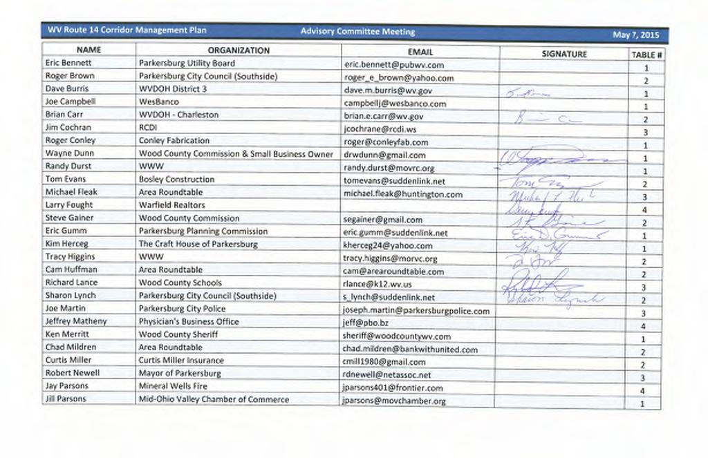
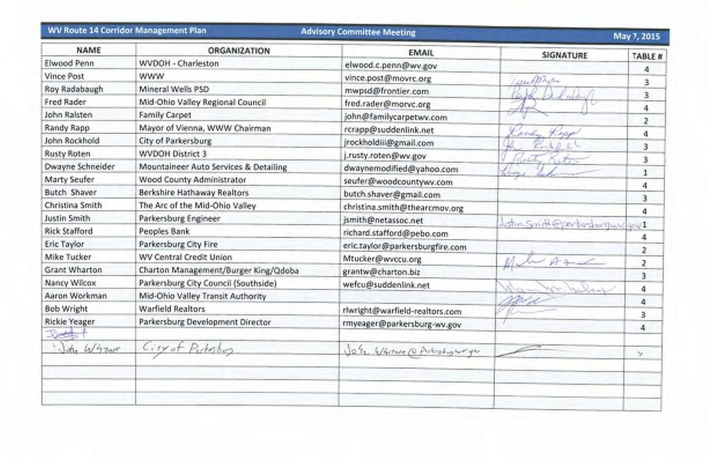
1 Wood Washington Wirt Interstate Planning Commission WV Route 14 Corridor Management Plan Advisory Committee Meeting Summary Location: Parkersburg City Building (1 Government Square, Parkersburg, WV 26101) Date: May 7, 11:30 a.m. 1:30 p.m. Attendees: Dave Burris, WVDOH District 3 Brian Carr, WVDOH Charleston Wayne Dunn, Wood County Commission and Small Business Owner Randy Durst, WWW Tom Evans, Bosley Construction Michael Fleak, Area Roundtable Larry Faught, Warfield Realtors Steve Gainer, Wood County Commission Eric Gumm, Parkersburg Planning Commission Kim Herceg, The Craft House of Parkersburg Tracy Higgins, WWW Richard Lance, Wood County Schools Sharon Lynch, Parkersburg City Council (Southside) Vince Post, WWW Roy Radabaugh, Mineral Wells PSD Fred Rader, Mid Ohio Valley Regional Council Randy Rapp, Mayor of Vienna, WWW Chairman John Rockhold, City of Parkersburg Rusty Roten, WVDOH District 3 Dwayne Schneider, Mountaineer Auto Services & Detailing Justin Smith, Parkersburg Engineer Mike Tucker, WV Central Credit Union John Whitmore, City of Parkersburg Nancy Wilcox, Parkersburg City Council (Southside) Aaron Workman, Mid Ohio Valley Transit Authority Bob Wright, Warfield Realtors Jared Anderson, WVU Sustainable Land Use Law Clinic Rodney Holbert, Burgess & Niple, Inc. Kris Popovich, Burgess & Niple, Inc. Kendra Schenk, Burgess & Niple, Inc. Steve Thieken, Burgess & Niple, Inc. Meeting Purpose To introduce the study process To obtain input regarding the corridor vision, goals and objectives, issues and needs, and ideas for improvement. Introduction, Background, and Process Discussion Randy Durst welcomed the group and provided a brief history and background regarding the planning effort and WWW s goals and objectives. Steve Thieken described the study area and the planning process (presentation attached) including a description of what a Corridor Management Plan involves and its benefits 1
2 Wood Washington Wirt Interstate Planning Commission WV Route 14 Corridor Management Plan Advisory Committee Meeting Summary Workshop Exercises Attendees participated in a series of group and individual exercises to help establish the corridor strengths and weaknesses; corridor vision, goals and objectives; and ideas for improvements. Attendees were assigned to a specific table for group discussion purposes. Table assignments are attached. Corridor Strengths and Weaknesses Each table was asked to answer the following questions: What are the biggest strengths of this corridor (be specific)? What are the biggest weaknesses of this corridor (be specific)? The brainstorming and discussion was facilitated by a consultant team member who listed all ideas on flip charts (copies attached). The group was then asked to identify the strengths and weaknesses that had the greatest level of consensus. The most popular responses included: Strengths: o The corridor is a major north/south connector in the area o The corridor is not entirely built out which leaves room for more development o The corridor serves as a public transit route o The corridor provides access to I 77 and US 50 o The high volume of traffic on the corridor is good for many businesses o In the southern portion of the corridor (the new four lane section), traffic flow is safe and efficient o Public water and sewer is provided along the corridor Weaknesses: o Traffic congestion (specifically from Blizzard/Pike/Broadway to Rayon/Gihon) o No sidewalks o Too many access points (driveways and side streets) o Drivers use middle turn lane for passing and not just turning as intended o There is no east/west access to Route 95 o There are no land use regulations o Traffic congestion causes delays for emergency vehicles o Traffic signal timings do not seem coordinated for progression of traffic o The school zone at Parkersburg South High School impedes traffic flow both because of the reduced speed limit and because of pedestrians crossing Blizzard Street o The commercial areas, specifically in the northern portion of the corridor, take away from the initiative to revitalize downtown Parkersburg 2
3 Wood Washington Wirt Interstate Planning Commission WV Route 14 Corridor Management Plan Advisory Committee Meeting Summary Corridor Vision Each individual was given three pieces of paper and was asked to write on each sheet one or words that describe: What should the corridor be? The visions were broken up into the following categories with the words and ideas listed below: Efficient o 4 Lanes o 5 Lane o Better Turning Lanes o Congestion Free o Control Access o Effective o Efficient (3) o Efficient Flow o Efficient Long Term o Flowing o Flowing Access o Fluent Traffic Flow o Good Traffic Flow (2) o Less Traffic o Smooth Flow o Travel Efficiency o Uncongested Attractive o Aesthetic o Aesthetically Appealing o Aesthetically Attractive o Attractive Convenience o Awesome o Future Looking o Lighted o Nice Looking into City o Nice Presentation to Southside o Streetscaped o Well Designed Economically Healthy o Attractive for Growth o Business Friendly o Commercially Friendly o Developable (2) o Easy Accessibility for Business o Economic Development o Economically Healthy o Good for Business o Planned Development Safe o Safe (9) o Safe Movement Community Focused o A Place o Beneficial o Community Minded o Community Service o Enhance Quality of Life o Give Back to Residents (their streets) o Good for the Public o User Friendly Good Access and Connectivity o Accessible (2) o Better Access o Connected to Route 95 o Easy Access o North/South Connected Constructability o Cost Effective o Economical o Economically Feasible 3
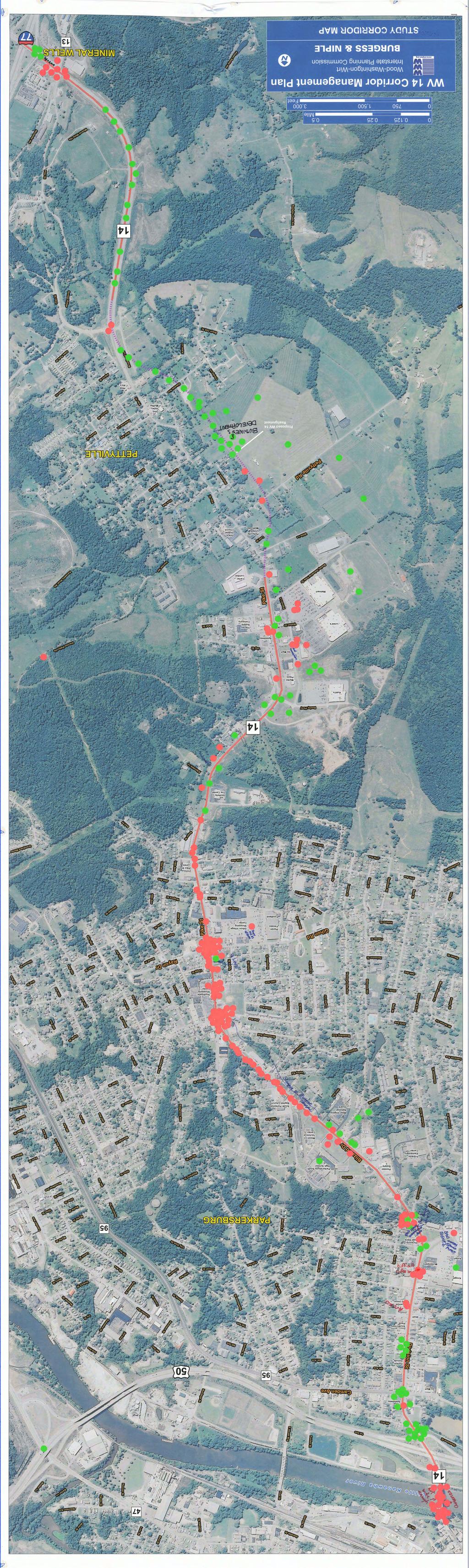
4 Wood Washington Wirt Interstate Planning Commission WV Route 14 Corridor Management Plan Advisory Committee Meeting Summary Other o o o o Flexible Forward Thinking Good Signage Multi Use o o o o NOW Regulated Seattle 4 th Avenue Straight Good Places/Bad Places Attendees were also given 20 dots, 10 red and 10 green, to place in the corridor. The red dots represent bad places while green indicate good places. Attendees were also asked to write a few words on the map describing why they placed their dots in those locations. A scanned copy of the map is attached. Good areas that had several green dots included: o US 50 interchange with Division Street o Division Street and Camden Avenue intersection o Division Street between Sixth Avenue and Seventh Avenue o In the vicinity of Kohl s o Along the proposed WV 14 realignment Business development o Along the four lane, median divided segment of WV 14, north of the I 77 interchange Bad areas that had several red dots included: o Fifth Street Bridge Congested Not wide enough o Division Street at 10 th Avenue Difficult lefts in o Blizzard Drive at 12 th Avenue Poor business access o Blizzard Drive from Parkersburg South High School to Broadway Avenue/Pike Street intersection Bumper to bumper traffic o Blizzard Drive/Broadway Avenue/Pike Street intersection o Pike Street at Southgate Shopping Center entrance o Pike Street at Rayon Drive/Gihon Road intersection o WV 14 at Sam s Creek Road/Pike Street Unsafe 4
5 Wood Washington Wirt Interstate Planning Commission WV Route 14 Corridor Management Plan Advisory Committee Meeting Summary Strategies to Consider Attendees reconvened at their assigned tables to answer the question: What should be done to make the corridor the best it can be now and in the future? The brainstorming and discussion was facilitated by a consultant team member who listed all ideas on flip charts (copies attached). The group was then asked to identify which ideas had the greatest level of consensus. The most popular responses included: Design for future expansion construct four lane section to Patriot Center Construct an east west corridor (Route 95/Camden Avenue to near Glotfelty Tire) Construct roundabouts at some intersections Reconfigure the Blizzard Drive/Pike Street/Broadway Avenue intersection Implement strategies and policies that preserve the right of way Develop access management policies Form land use committees that provide subdivision regulations and corridor specific regulations Plan strategically for the best land use Allocate adequate funding Provide bicycle and pedestrian facilities in new development and roadway plans 5
6
7
8 5/26/2015 WV 14 Corridor Management Plan Wood Washington Wirt Interstate Planning Commission March 18, 2015 Study Area WV 14 from I 77 to US 50 Follows proposed realignment 1
9 5/26/2015 What is a Corridor Management Plan? A Corridor Management Plan is a set of transportation and land use strategies that address current and future transportation needs. Source: WV Corridor Management Handbook Typical Strategies Transportation system changes that improve safety, reduce congestion, and improve access for pedestrians and bicyclists Tools to help local governments guide changes in land use and development to protect the transportation system Methods to preserve and acquire road right of way for future improvements Design guidance for corridor aesthetics and other community features Ways to improve cooperation between government jurisdictions Source: WV Corridor Management Handbook 2
10 5/26/2015 Keys to a good Corridor Management Plan Provides a mix of strategies that are mutually reinforcing and consistent with an agreed upon vision for the corridor Provides a set of well defined, prioritized actions, and define clear responsibilities for the implementation of the plan s strategies Source: WV Corridor Management Handbook Goals of a Corridor Management Plan Identify and address transportation issues before they turn into critical problems that can affect the quality of life and limit economic development Promote coordinated transportation and land use solutions along a corridor, rather than piecemeal initiatives that may work against each other To bring a diverse group of stakeholders together to agree on mutually beneficial strategies and the ongoing steps necessary to achieve them Source: WV Corridor Management Handbook 3
11 5/26/2015 Goals of a Corridor Management Plan Save money through strategies that are less expensive than major capital investments. Improving traffic operations Increase mode choices Reducing access points Better land use policies Develop creative, win win, strategies for supporting sustainable economic development. Preserve and enhance West Virginia s natural environment and the unique character of its communities. Source: WV Corridor Management Handbook Why now? 4

12 5/26/2015 CMP Development Process Overview Building the Foundation Framing the Options Present the Plan Make Adjustments Building the Foundation (Spring 2015) Precisely define/quantify the problems, issues, and needs in the corridor Establish partnership with stakeholders and public through an open process Articulate the Vision, Goals and Objectives for the corridor Avoid arriving at solutions at this stage 5
 Tell the story What is the vision and how we got here How the plan represents the best courses of actions to meet the goals and objectives for the corridor Build broad support for plan")
13 5/26/2015 Framing the Options (Summer 2015) Solidify ideas and options for improvements and policies Evaluate options and quantify results Clearly communicate options and tradeoffs Present the Plan (Fall 2015) Tell the story What is the vision and how we got here How the plan represents the best courses of actions to meet the goals and objectives for the corridor Build broad support for plan and its strategies 6

14 5/26/2015 Finalize and Implement the Plan (Winter 2015/2016) Make adjustments and polish the plan Continue to build support Begin to implement the plan Stakeholder Involvement is Critical Involve developers, property owners, local government officials and politicians, police and fire departments, other public entities, concerned citizens, etc. Getting buy in will make the implementation of the recommendations much more feasible Include education on benefits of access management and multimodal transportation improvements Create a partnering relationship with stakeholders 7
15 5/26/2015 Three Levels of Engagement Steering Group small group of key decision makers who will be most involved in ultimately implementing the plan. Five meetings planned. Advisory Group larger and diverse group of stakeholders in the corridor. Two meetings and other communications with this group will occur. Steering group members will also participate in these meetings. Public Engaged early and then near the end of the process to help shape the vision, goals and objectives, and to react to the preliminary recommendations. Next Steps Help us out today! Public Open House Meeting this evening Provide any data, studies, or other information that would be useful for the study ASAP Meet again in late summer to review and discuss proposed strategies 8
16 5/26/2015 Corridor Strengths/Weaknesses (20 minutes) Question 1 What are the biggest strengths of this corridor (be specific)? Question 2 What are the biggest weaknesses of the corridor (be specific)? Write all ideas on flip charts Star the ones that had the greatest consensus Corridor Vision (15 minutes) Each person gets 3 pieces of paper In one or two words write on each piece What should the corridor be? 9
17 5/26/2015 Dot Exercise (20 minutes includes break) Good places / Bad places exercise Each person gets 20 dots (10 of each color) Place each dot in corridor Green dot represents good places Red dot represents bad places Make a note on map why you placed them there Place no more than three dots in any one place Not necessary to use all of your dots Strategies to Consider (20 minutes) What should be done to make the corridor the best it can be now and in the future? Write all ideas on flip charts Star the ones that had the greatest consensus 10
18 WV Route 14 Corridor Management Plan Advisory Committee Meeting May 7, 2015 Table 1 Rodney Holbert Name Dave Burris Wayne Dunn Randy Durst Eric Gumm Kim Herceg Dwayne Schneider Justin Smith Adam Stout? Organization WVDOH District 3 Wood County Commission & Small Business Owner WWWW Parkersburg Planning Commission The Craft House of Parkersburg Mountaineer Auto Services & Detailing Parkersburg Engineer Parkersburg Engineer
19
20

21
22 WV Route 14 Corridor Management Plan Advisory Committee Meeting May 7, 2015 Table 2 Jared Anderson Name Brian Carr Tom Evans Steve Gainer Tracy Higgins Sharon Lynch Mike Tucker Organization WVDOH Charleston Bosley Construction Wood County Commission WWWW Parkersburg City y Council (Southside) WV Central Credit Union
23
24
25
26 WV Route 14 Corridor Management Plan Advisory Committee Meeting May 7, 2015 Table 3 Kendra Schenk Name Michael Fleak Richard Lance Vince Post Roy Radabaugh John Rockhold Rusty Roten Bob Wright Organization Area Roundtable e Wood County Schools WWWW Mineral Wells PSD City of Parkersburg WVDOH District 3 Warfield Realtors
27
28
29
30
31 WV Route 14 Corridor Management Plan Advisory Committee Meeting May 7, 2015 Table 4 Kris Popovich Name Larry Fought Fred Rader Randy Rapp Nancy Wilcox John Whitmore Aaron Workman Organization Warfield Realtors Mid Ohio Valley Regional Council Mayor of Vienna, WWW Chairman Parkersburg Cityy Council (Southside) City of Parkersburg Mid Ohio Valley Transit Authority
32
33
34
35
36
37
Scope of Services. River Oaks Boulevard (SH 183) Corridor Master Plan
 Corridor Master Plan") Scope of Services River Oaks Boulevard (SH 183) Corridor Master Plan PROJECT AREA The project area consists of the River Oaks Boulevard (SH 183) corridor bounded by SH 199 at the northern end and the Trinity
Scope of Services River Oaks Boulevard (SH 183) Corridor Master Plan PROJECT AREA The project area consists of the River Oaks Boulevard (SH 183) corridor bounded by SH 199 at the northern end and the Trinity
3. VISION AND GOALS. Vision Statement. Goals, Objectives and Policies
 Vision Statement Queen Creek s interconnected network of parks, trails, open spaces and recreation opportunities provide safe and diverse activities and programs that sustain its unique, small town, equestrian
Potential Green Infrastructure Strategies May 6, 2015 Workshop
 Potential Green Infrastructure Strategies May 6, 2015 Workshop Background The City of Cortland is developing the Tioughnioga Urban Headwaters Green Infrastructure Action Plan with funding from the National
The Illinois Department of Transportation and Lake County Division of Transportation. Route 173, including the Millburn Bypass
 The Illinois Department of Transportation and Lake County Division of Transportation welcome you to this Public Hearing for U.S. Route 45 from Illinois Route 132 to Illinois Route 173, including the Millburn
Implementation Guide Comprehensive Plan City of Allen
 Implementation Guide 2030 Comprehensive Plan City of Allen DRAFT 2015 Implementation Guide Allen 2030 Comprehensive Plan INTRODUCTION The Comprehensive Plan serves as a guide for the growth and development
7Page 91 CLEMMONS COMMUNITY COMPASS 7 COMMUNITY CHARACTER
 7 Community Character The beauty of Clemmons won t necessarily be a reflection of our past, but our future. This quote from Comprehensive Plan Steering Committee member Wayne Dodson captures the essence
Executive Summary. NY 7 / NY 2 Corridor
 Executive Summary NY 7 / NY 2 Corridor Transportation and Land Use Study December 2005 Prepared for: Town of Colonie Capital District Transportation Committee Prepared by: Introduction: Land use decisions
38 Queen s University Campus Master Plan Part 1
 38 Queen s University Campus Master Plan Part 1 46 The Campus at the City Scale Chapter 4 The Campus at the City Scale 39 Queen s is an urban University centrally located in Kingston. Decisions made by
CITY OF CHARLOTTESVILLE, VIRGINIA CITY COUNCIL AGENDA
 CITY OF CHARLOTTESVILLE, VIRGINIA CITY COUNCIL AGENDA Agenda Date: December 16, 2013 Action Required: Adoption of Resolution Presenter: Staff Contacts: Title: James E. Tolbert, AICP, Director of NDS James
A Claustrophobic Corridor Grows Up
 A Claustrophobic Corridor Grows Up Presenters: Chris Bauserman, PE, PS Delaware County Engineer Jeff Griffin, PE Burgess & Niple, Inc. Brian Moore, PE Burgess & Niple, Inc. PROJECT OVERVIEW Sawmill Parkway
TENNESSEE STATE ROUTE 109 CORRIDOR MANAGEMENT AGREEMENT MEMORANDUM OF UNDERSTANDING CORRIDOR MANAGEMENT ALONG STATE ROUTE 109
 TENNESSEE STATE ROUTE 109 CORRIDOR MANAGEMENT AGREEMENT MEMORANDUM OF UNDERSTANDING CORRIDOR MANAGEMENT ALONG STATE ROUTE 109 I. Purpose The purpose of this Agreement is to provide a framework for the
Route 1 Corridor Study
 Route 1 Corridor Study Westbrook, Connecticut A Vision for the Connecticut Shoreline Public Informational Meeting July 28, 2015 Lower Connecticut River Valley Council of Governments Fitzgerald & Halliday,
Project Overview. Fairfax County Parkway Widening Fairfax County. Get Involved. Public Information Meeting. Contact Information
 Get Involved VDOT representatives will review and evaluate information received as a result of this meeting. Please fill out the comment sheet provided in this brochure if you have any comments or questions.
North Fair Oaks Community Plan Summary and Information
 North Fair Oaks Community Plan Summary and Information WHAT IS THE NORTH FAIR OAKS COMMUNITY PLAN? The North Fair Oaks Community Plan is part of the San Mateo County General Plan, and establishes policies
Access Management: An Overview
 Figures 1-5 Below Evolution of development along a highway. In the early stages, land along the road is used for farming with little traffic generated. As time passes, the highway corridor becomes a de
Chapter 2: Vision, Goals and Strategies
 Chapter 2: Vision, Goals and Lake Elmo Today & Tomorrow Comprehensive Plan 2040 2 VISION, GOALS & STRATEGIES - DRAFT 4-6-2018 INTRODUCTION Comprehensive Plan Purpose Perhapse the most important objective
CHAPTER 7: Transportation, Mobility and Circulation
 AGLE AREA COMMUNITY Plan CHAPTER 7 CHAPTER 7: Transportation, Mobility and Circulation Transportation, Mobility and Circulation The purpose of the Transportation, Mobility and Circulation Chapter is to
Sherri Ferguson. President/CEO Portland Chamber of Commerce. Tennessee Certified Economic Developer Capstone Project
 Sherri Ferguson President/CEO Portland Chamber of Commerce Tennessee Certified Economic Developer Capstone Project Strategic Plan Development for the North Gateway of Portland, Tennessee The New Gateway
Illustration of Eastlake Farmer s Cooperative Grain Elevator. Chapter 5: implementation 5-1
 Illustration of Eastlake Farmer s Cooperative Grain Elevator Chapter 5: implementation 5-1 chapter 5: implementation Introduction The Eastlake Subarea Plan includes a wide range of recommendations intended
TORONTO COMPLETE STREETS GUIDELINES
 TORONTO COMPLETE STREETS GUIDELINES Presentation by Fiona Chapman, Manager, Pedestrian Projects Public Realm Section, Transportation Services, City of Toronto June 2017 PURPOSE OF THE PROJECT To develop
John M. Fleming Managing Director, Planning and City Planner. Old East Village Dundas Street Corridor Secondary Plan Draft Terms of Reference
 Report to Planning and Environment Committee To: From: Subject: Chair and Members Planning & Environment Committee John M. Fleming Managing Director, Planning and City Planner Old East Village Dundas Street
Citizen Engagement for a Sustainable Built Environment
 Citizen Engagement for a Sustainable Built Environment Examples and Case Studies from Michigan Communities Genesee County Metropolitan Planning Commission 10 th Annual Planning Forum October 23, 2015 Wayne
9/19/2018 TODAY S WEBINAR AGENDA CONTINUING EDUCATION UPCOMING TRAINING FROM APBP
 TODAY S WEBINAR AGENDA 3:00 pm: Introduction 3:05 pm: Presentation 3:45 pm: Questions 4:00 pm: Webinar Ends For technical assistance during the webinar: 1-800-263-6317 Choose these prompts: 1, 1, 1 CONTINUING
Public input has been an important part of the plan development process.
 Lakewood s Comprehensive Plan recognizes that transportation helps shape the community, and that the way the community provides for the safe and efficient movement of people affects the character of the
Gold Line Bus Rapid Transit Transit Oriented Development (BRTOD) Helmo Station Area Plan
 Helmo Station Area Plan") Appendix F Gold Line Bus Rapid Transit Transit Oriented Development (BRTOD) Helmo Station Area Plan Introduction and Purpose of the Plan The Gold Line Bus Rapid Transit facility is an eleven-mile dedicated
Appendix F Gold Line Bus Rapid Transit Transit Oriented Development (BRTOD) Helmo Station Area Plan Introduction and Purpose of the Plan The Gold Line Bus Rapid Transit facility is an eleven-mile dedicated
Parks Master Plan Implementation: Phase I Waterfront Use and Design REPORT #: September 7, 2016 File #
 0 'O DI Lan-171-14 1 - THE CORPORATION OF THE TOWN OF COBOURG..,. STAFF REPORT TO: FROM: Mayor and Members of Council Dean A. Hustwick, Director of Recreation and Culture DATE OF MEETING: Committee of
Denton. A. Downtown Task Force
 2 Public Involvement Early and ongoing public involvement was solicited so that the public had ample opportunity to help direct the DTIP s concepts and implementation strategies. The residents of Denton
Kenilworth Avenue and Town of Cheverly Industrial Study Briefing
 Kenilworth Avenue and Town of Cheverly Industrial Study Briefing The Maryland-National Capital Park and Planning Commission Prince George s County Planning Department www.pgplanning.org Vanasse Hangen
MAIN STREET ECONOMIC DEVELOPMENT STRATEGY
 MAIN STREET ECONOMIC DEVELOPMENT STRATEGY A PATHWAY TO A BETTER POUGHKEEPSIE DRAFT Working Paper #2: Planning Strategies Submitted December 1 st, 2015 to the City of Poughkeepsie LAND USE LAW CENTER PACE
St. Clair Avenue West Area Transportation Master Plan
 1 (Between Keele Street and Old Weston Road) Public Information Centre 1 December 2, 2015 2 Welcome Welcome to the first Public Information Centre for the St. Clair Avenue West Area. The panels will present
V. Vision and Guiding Principles
 V. Vision and Guiding Principles The Master Plan for the Powers Ferry Corridor seeks a foundation in the desires of the community. At times, various elements of the community offered opposing viewpoints,
ITEM #8. Regional Smart Growth Program. Regional Smart Growth Program. Presentation Overview. Coast Highway Vision and Stategic Plan.
 Regional Smart Growth Program Economic Development Commission What is Smart Growth? Adopted as part of the Regional Comprehensive Plan (RCP) RCP provides vision for region based on Smart Growth and sustainability
Section 1. Executive Summary
 Executive Summary (This page left blank intentionally) Executive Summary Background Economic growth in southern Leavenworth County over the past decade has been strong. As both the number of business and
SCTPO Project Summary September 2014
 A1A MULTIMODAL CORRIDOR PLANNING AND ENGINEERING ANALYSIS Florida Department of Transportation SCTPO Project Summary September 2014 PRESENTATION FOOTER Meeting Agenda What We Plan To Do Project Background
Date: April 10, 2017 City Council Work Session April 24, 2017: Status Report on the Comprehensive Plan Update and Transportation Master Plan
 AGENDA REPORT To: From: By: Honorable Mayor and City Council Members Warren Hutmacher, City Manager Sharon Ebert, Director Community Development Date: April 10, 2017 Agenda: City Council Work Session April
Introduction. Chapter 1. Purpose of the Comprehensive Plan Plan Organization Planning Process & Community Input 1-1
 Chapter 1 Introduction Lakewood 2025: Moving Forward Together Purpose of the Comprehensive Plan Plan Organization Planning Process & Community Input 1-1 Purpose of the Comprehensive Plan The Comprehensive
Urban Planning and Land Use
 Urban Planning and Land Use 701 North 7 th Street, Room 423 Phone: (913) 573-5750 Kansas City, Kansas 66101 Fax: (913) 573-5796 Email: planninginfo@wycokck.org www.wycokck.org/planning To: From: City Planning
Community Meeting #2.1
 Community Meeting #2.1 Thursday, October 20, 2016, 7:00 p.m. to 9:00 p.m. Eliot Elementary School, 475 Old Gilroy Street, Gilroy, CA 95020 Meeting Summary The City of Gilroy held its third community meeting
Rezoning Issues Setting a Foundation for Zoning Decisions
 Rezoning Issues Setting a Foundation for Zoning Decisions City Council Workshop May 2, 2016 Agenda Goal Need actionable items and sequence of steps Foundation for Zoning Decisions Council Workshop Discussion
Alaskan Way, Promenade, and Overlook Walk Final EIS Appendix D - Supplemental Draft EIS Comments and Responses October 2016.
 B-001-001 The use of Columbia Street for two-way transit was a decision made by King County Metro as part of its Southwest Transit Pathway evaluation. This project is separate from AWPOW. B-001-002 Modeling
SUBJECT: Waterfront Hotel Planning Study Update TO: Planning and Development Committee FROM: Department of City Building. Recommendation: Purpose:
 Page 1 of Report PB-23-18 SUBJECT: Waterfront Hotel Planning Study Update TO: Planning and Development Committee FROM: Department of City Building Report Number: PB-23-18 Wards Affected: 2 File Numbers:
PLAN ELEMENTS WORKSHOP. April 5, 2016
 PLAN ELEMENTS WORKSHOP April 5, 2016 needs more housing. But there is no one-size fits-all solution. Every neighborhood has its own character. In some places, density is not only appropriate it is badly
SAN RAFAEL GENERAL PLAN 2040 INTRODUCTION AND OVERVIEW
 SAN RAFAEL GENERAL PLAN 2040 INTRODUCTION AND OVERVIEW Steering Committee Presentation February 14, 2018 Purpose of General Plan Guide land use and development decisions Coordinate transportation, infrastructure,
SUMMARY Downtown Malabar Meeting on July 30, 2013 State Road (SR) 514 (Malabar Road) Project Development and Environment (PD&E) Study
 514 (Malabar Road) Project Development and Environment (PD&E) Study") SUMMARY Downtown Malabar Meeting on July 30, 2013 State Road (SR) 514 (Malabar Road) Project Development and Environment (PD&E) Study www.sr514malabar.com LOCATION: TIME: ATTENDEES: Malabar Town Hall 2725
SUMMARY Downtown Malabar Meeting on July 30, 2013 State Road (SR) 514 (Malabar Road) Project Development and Environment (PD&E) Study www.sr514malabar.com LOCATION: TIME: ATTENDEES: Malabar Town Hall 2725
Welcome! MILLENNIUM LINE BROADWAY EXTENSION. Over the next 30 years, Metro Vancouver will welcome 1 million new residents and 600,000 new jobs.
 WELCOME Welcome! MILLENNIUM LINE BROADWAY EXTENSION Over the next 30 years, Metro Vancouver will welcome 1 million new residents and 600,000 new jobs. The Broadway Corridor is home to the second largest
Lesson 6. Corridor Planning
 Lesson 6 Corridor Planning 1 Learning Outcomes Identify land use strategies and solutions that can be incorporated into multimodal transportation corridor plans Identify land use stakeholders and describe
Streets for People, Place-Making and Prosperity. #TOcompletestreets
 COMPLETE STREETS FOR TORONTO Streets for People, Place-Making and Prosperity COMPLETE STREETS: A NEW APPROACH A Complete Streets design approach considers the needs of all users people who walk, bicycle,
Secrest Short Cut and Monroe Expressway Small Area Plan AUGUST 29, 2018
 Secrest Short Cut and Monroe Expressway Small Area Plan AUGUST 29, 2018 Background and Process Monroe Expressway will be open by the end of 2018 Union County and Indian Trail identified a need to revisit
VIRGINIA / LAKE HIGHLAND TRANSPORTATION AND LAND USE STUDY
 VIRGINIA / LAKE HIGHLAND TRANSPORTATION AND LAND USE STUDY COMMUNITY MEETING #2 - PRESENTATION OVERVIEW 1 INTRODUCTION 2 CONTEXT STUDIES 3 VISION FRAMEWORK 4 DEVELOPMENT SCENARIOS 2 1 INTRODUCTION Project
Issues Requiring Future Study
 Issues Requiring Future Study Transportation planning is an ongoing process that tends to identify new issues as it finds solutions for others. Some issues are so complex that a solution to one problem
Town Center (part of the Comprehensive Plan)
") Town Center (part of the Comprehensive Plan) Mercer Island Town Center Looking North (2014) In 1994, a year-long process culminated in a set of design guidelines and code requirements for the Town Center
Town Center (part of the Comprehensive Plan) Mercer Island Town Center Looking North (2014) In 1994, a year-long process culminated in a set of design guidelines and code requirements for the Town Center
7Page 1 CLEMMONS COMMUNITY COMPASS 1 PLAN OVERVIEW
 1 Plan Overview WHAT IS I THE CLEMMONS COMMUNITY COMPASS? The Clemmons Community Compass is our community s comprehensive plan. It serves as our blueprint and provides direction for the future of the Village
I. INTRODUCTION. Project Background and Study Area
 I. INTRODUCTION Project Background and Study Area Freedom Parkway is a key east-west corridor connecting I-25 on the west to the Town of Kersey on the east, running approximately one to two miles south
RESEDA - WEST VAN NUYS COMMUNITY PLAN
 RESEDA - WEST VAN NUYS COMMUNITY PLAN Executive Summary As part of the initial outreach effort, the Department of City Planning hosted two workshops for the Reseda-West Van Nuys Community Plan Area during
PIKE PINE RENAISSANCE: ACT ONE. October 19, 2017
 PIKE PINE RENAISSANCE: ACT ONE October 19, 2017 WATERFRONT SEATTLE PROGRAM PROJECT INTRODUCTION Pike and Pine streets, between First and Melrose avenues Pedestrian and streetscape improvements Budget:
The Urban Core: Downtown Lincoln
 The 'P' Street corridor linking The Urban Core: Downtown Lincoln the Haymarket District to the Antelope Valley Parkway is a place of many possibilities. What are the conditions & attributes that will successfully
SH 199 Corridor Master Plan. Community Meeting No. 2 May 31, 2017
 Community Meeting No. 2 May 31, 2017 Transportation Projects On or Near SH 199 SH 199 from 0.3 miles south of FM 1886 to south end of Lake Worth bridge Construct freeway mainlanes and frontage roads 10-Year
The transportation system in a community is an
 7 TRANSPORTATION The transportation system in a community is an important factor contributing to the quality of life of the residents. Without a sound transportation system to bring both goods and patrons
Berkeley Strategic Transportation Plan
 Berkeley Strategic Transportation Plan 48 4. Priming the Pipeline 4. Priming the Project Pipeline Building on our history Using past studies that required the effort and input of all of Berkeley s distinct
Chapter 3 Community Involvement
 Chapter 3 Community Involvement Public involvement has been a vital component of the planning process in the preparation of this master planning document. The purpose of this citizen-led effort was to
Executive Summary. The Mebane CLP is not a regulatory document, but is intended to guide land development decisions. The plan includes:
 Executive Summary P URPOSE AND O RGANIZATION OF THE P LAN The City of Mebane, with input from citizens and an appointed CLP Advisory Committee, adopted Mebane by Design, a Comprehensive Land Development
The Lower SaLuda Greenway
 The Lower SaLuda Greenway InITIaTIve a FLourIShInG Greenway. a hub For economic GrowTh. a ConneCTIon BeTween CoMMunITIeS. In April 2017 the Michael J. Mungo Foundation and Lexington County commissioned
Port Lavaca Future Land Use
 Port Lavaca Future Land Use Introduction The City of Port Lavaca is beginning to see sustained growth, after many years of relative stable population. New single family homes, apartments, and businesses
EXPANDING THE NETWORK ALEXANDRIA, VIRGINIA
 EXPANDING THE NETWORK ALEXANDRIA, VIRGINIA David Whyte david.whyte@kimley-horn.com Overview Project Context Corridors Land Use Coordination Concepts Outreach and Coordination Results Core of the region
New York Avenue Streetscape and Trail Project Public Meeting #1 Summary
 New York Avenue Streetscape and Trail Project Public Meeting #1 Summary I. King Jordan Student Academic Center (SAC) Gallaudet University, Washington, DC February 23, 2017 Table of Contents 1.0 Introduction...
A BLUEPRINT FOR BROCKTON A CITY-WIDE COMPREHENSIVE PLAN
 A BLUEPRINT FOR BROCKTON A CITY-WIDE COMPREHENSIVE PLAN Public Meeting October 2016 1 Plan Summary and Discussion Public Meeting May 4 2017 City of Brockton Bill Carpenter, Mayor Department of Planning
2.0 PURPOSE AND NEED. 2.1 Purpose. 2.2 Need Traffic Congestion in and around Downtown Derry
 2.0 PURPOSE AND NEED Taking into consideration agency and public input, the purpose and need for the Project was identified early in Project planning. As noted in Appendix A, for purposes of meeting the
City of Hermosa Beach Administrative Policy #
 City of Hermosa Beach Administrative Policy # SUBJECT: Living Streets Policy Date: Approved by: City Council Authority: Public Works Department & Community Development Department Mayor, PURPOSE The City
Status Update (2006 vs. Now) Citizen s Advisory Committee February Plan for Prosperity
 Citizen s Advisory Committee February Plan for Prosperity") Status Update (2006 vs. Now) Citizen s Advisory Committee February 2018 Plan for Prosperity 2000 2017 2000 2017 Gardnerville Population 6,000 5,760 5746 5,500 5,000 5,067 5,550 5,165 5,394 5,412 5,250
Status Update (2006 vs. Now) Citizen s Advisory Committee February 2018 Plan for Prosperity 2000 2017 2000 2017 Gardnerville Population 6,000 5,760 5746 5,500 5,000 5,067 5,550 5,165 5,394 5,412 5,250
Urban Design Manual PLANNING AROUND RAPID TRANSIT STATIONS (PARTS) Introduction. Station Study Areas
 Introduction. Station Study Areas") 111111 PLANNING AROUND RAPID TRANSIT STATIONS (PARTS) Introduction The ION rapid transit system will link Waterloo, Kitchener and Cambridge through a central transit corridor (CTC). There are a number
111111 PLANNING AROUND RAPID TRANSIT STATIONS (PARTS) Introduction The ION rapid transit system will link Waterloo, Kitchener and Cambridge through a central transit corridor (CTC). There are a number
The GATEWAYS Sub Area Master Plan. City of Walker
 The GATEWAYS Sub Area Master Plan City of Walker Introduction: The Walker City Commission and Planning Commission decided in 2011 to create a sub-area master plan for the Remembrance Road and Wilson Avenue
2030 Comprehensive Plan VISION STATEMENT
 RESOURCE DOCUMENT for Steering Committee Meeting #2 July 12, 2017 2030 Comprehensive Plan VISION STATEMENT Steering Committee from 2008 Established the Lauderdale s Vision as: Creating a livable, lovable
State Highway 5 Corridor Context Sensitive Master Plan
 ADOPTED June 17, 2014 (Resolution 2014-06-071) Travel Lane Travel Lane 11 11 Median 16 Min State Highway 5 Corridor Context Sensitive Master Plan 1 Prepared for: Prepared by: State Highway 5 Corridor
Chapter 1.0 Introduction
 Chapter 1.0 Introduction 1.1 Background The North Metro commuter rail line is part of the RTD FasTracks regional transit system expansion program to build more than 100 miles of rail transit throughout
Small Area Plan. South Gateway
 Small Area Plan Adopted May 12, 2008 South Gateway Purpose. The South Gateway Small Area Plan defines the City s expectations for the future of the southern entrance to the City at Interstate 85 and Highway
Project Overview. Get Involved. Public Information Meeting. Contact Information
 Get Involved VDOT representatives will review and evaluate information received as a result of this meeting. Please fill out the comment sheet provided in this brochure if you have any comments or questions.
Transportation. Strategies for Action
 Transportation A major priority for the Overlake Neighborhood is to develop a multimodal transportation system. To achieve this system, a balance has to be found among travel, circulation and access needs;
Complete Streets Master Plan for Downtown New Britain CRCOG Transportation Committee Meeting Monday, December 9, 2013
 CRCOG Transportation Committee Meeting Monday, December 9, 2013 Introduction Why the Project was Initiated About Downtown New Britain Master Plan Goals Master Plan Overview Master Plan Study Areas and
124 Subarea Visions. Vision Plan. A. Nelessen Associates, INC I Visioning I Planning I Urban Design
 Subareas 124 Subarea Visions The next seven sections describe specific recommendations tailored to each subarea. Each subarea is discussed separately except for certain aspects of 95th Street and Antioch
EXISTING COMPREHENSIVE PLAN
 EXISTING COMPREHENSIVE PLAN Town Center Land Use Element: V. LAND USE POLICIES Town Center Mercer Island's business district vision as described in "Your Mercer Island Citizen-Designed Downtown" was an
Panama City Beach Community Redevelopment Agency Condo Con Property Owner Conference & Expo November 14, 2014
 Panama City Beach Community Redevelopment Agency Condo Con Property Owner Conference & Expo November 14, 2014 Front Beach Road CRA On November 30, 2000, the City created the Panama City Beach Community
CITY OF UNION CITY MINUTES GENERAL PLAN ADVISORY COMMITTEE
 CITY OF UNION CITY MINUTES GENERAL PLAN ADVISORY COMMITTEE WEDNESDAY, MARCH 4, 2015, 6:30 P.M. IN THE CITY COUNCIL CONFERENCE ROOM OF CITY HALL 34009 ALVARADO-NILES BLVD., UNION CITY, CALIFORNIA Attachment
Project Goal. RRRC Living Towns Planning Workshp. Town of Halifax Revitalization Project. Dynamic Planning & Management Duo: July 12, 2006
 Project Goal Town of Halifax Revitalization Project RRRC Living Towns Planning Workshp July 12, 2006 Town of Halifax Halifax County *** Revitalization Project Goal*** To create Economic Opportunity and
public workshop #1 november 25, 2015
 public workshop #1 november 25, 2015 Agenda Introductions Project Purpose Key Objectives Listen + Learn from You Explain the Streetscape Planning process Project Timelines Project partners City of Edmonton
Acknowledgments. City of East Peoria. City of Washington. Aldermen. Commissioners. Staff. Staff. Planning Consultant. David Mingus, Mayor
 City of East Peoria & City of Washington ILLINOIS ROUTE 8-SUNNYLAND CORRIDOR PLAN August 30, 2010 8 GTON WASHIN 8 Acknowledgments City of Washington Gary W. Manier, Mayor Aldermen Bob Brucks, Ward I Jim
Citizen Advisory Committee Meeting #3.2
 Citizen Advisory Committee Meeting #3.2 August 10, 2016, 7:00 p.m. to 9:00 p.m. Police Department Conference Room, 7301 Hanna Street, Gilroy, CA 95020 Meeting Summary I. Call to Order Members present:
Mississippi Drive Corridor Revitalization. A DestinationTransportation Project...
 Mississippi Drive Corridor Revitalization A DestinationTransportation Project... Mississippi Drive Corridor Revitalization Welcome! Tonight s Agenda: Further define the Scope of the Project Discuss the
Cannards Grave Road Shepton Mallet Stakeholder Workshop. 2 nd June 2016
 Cannards Grave Road Shepton Mallet Stakeholder Workshop 2 nd June 2016 Overview Start of a process: Looking at the land south of the town, to the west of Cannards Grave Road, east of Compton Road as identified
Places29: List of Implementation Projects
 Important Points to Keep in Mind When Using This List Places29: List of s Each of the projects in this List represents an action needed to implement the Places29 Master Plan. The projects are grouped first
Por favor, levanten la mano si necesita traduccion en espanol Please raise your hand if you need Spanish translation
 FEDERAL BOULEVARD CORRIDOR WIDE STUDY PUBLIC MEETING #1 APRIL 27, 2016 Por favor, levanten la mano si necesita traduccion en espanol Please raise your hand if you need Spanish translation HDR DESIGN WORKSHOP
Town of Cobourg Heritage Master Plan. Statutory Public Meeting
 Town of Cobourg Heritage Master Plan Statutory Public Meeting April 25 th 2016 Presentation Overview 1. Introduction 2. Project background and schedule overview 3. Review of strategic direction content
Study Area. Capitol Way. Greening America s Capitals 11/13/2014. A Greening America s Capitals Project
 Olympia, WA: Greening Capitol Way Supporting Communities move towards sustainability is a priority for the federal government. A Greening America s Capitals Project Office of Sustainable Communities U.S.
TOWN OF BETHLEHEM MEETING SUMMARY LOCAL WATERFRONT REVITALIZATION PROGRAM UPDATE
 TOWN OF BETHLEHEM LOCAL WATERFRONT REVITALIZATION PROGRAM UPDATE MEETING SUMMARY Purpose: LWRP Update Public Workshop #3 Date and Time: October 24, 2017, 6:00 pm - 8:00 pm Location: Town Hall, 445 Delaware
ELMVALE ACRES SHOPPING CENTRE MASTER PLAN
 ELMVALE ACRES SHOPPING CENTRE MASTER PLAN Contents 1.0 INTRODUCTION... 2 2.0 LOCATION... 2 3.0 EXISTING CONTEXT... 2 4.0 VISION & GUIDING PRINCIPLES... 2 5.0 LAND USE AND BUILT FORM... 4 5.1 St. Laurent
Lakeview and Port Credit District Policies Review Public Engagement Process
 Lakeview and Port Credit District Policies Review Public Engagement Process Brook McIlroy Planning + Urban Design/PACE Architects MSAi Architects Poulos and Chung Transportation Engineers December 11,
Cobb County Design Guidelines Mableton Parkway & Veterans Memorial Highway Community Design Workshop January 12, 2017
 Community Design Workshop January 12, 2017 Agenda Opening Remarks / Introductions Scope of Work Existing Conditions Key Issues / Opportunities VPS Summary Draft Vision & Goal Statement Implementation Concepts
PROJECTS AND THE PUBLIC ART MASTER PLAN
 MEMO TO: PUBLIC ART STEERING COMMITTEE MEMBERS FROM: SHARI COOPER, DEVELOPMENT PROJECT COORDINATOR DATE: FEBRUARY 24, 2017 SUBJECT: AGENDA ITEM 5.A: PUBLIC ART PROJECT FOR 2017-18 BACKGROUND One of the
Preliminary Port Towns Sector Plan and Proposed Sectional Map Amendment March 2009
 Preliminary Port Towns Sector Plan and Proposed Sectional Map Amendment March 2009 BLADENSBURG u COLMAR MANOR u COTTAGE CITY u EDMONSTON The Maryland-National Capital Park and Planning Commission Prince
This page intentionally blank.
 This page intentionally blank. Parks, Recreation, and Open Space Chapter Relationship to Vision Vision Parks, Recreation and Open Space Chapter Concepts County Government. County government that is accountable
About Momentum Midland
 About Momentum Midland Achieving a community s full potential in terms of economic development and quality of life is critically important to its long term sustainability. Core to achieving this is a vibrant