W A N A K A L A K E F R O N T
|
|
|
- Grace Johnson
- 6 years ago
- Views:
Transcription

1 W A A K A L A K E F R O T D E V E L O P M E T P L A DECEMBER 205 DRAFT FOR REVIEW DRAFT
 Prepared by: Reset Urban Design Ltd Document Status: Revision Version Date Issued A Draft")
2 Contents 0 Introduction - Background - Existing Documents - Location 02 Context - Existing Character - Previous Plans 03 Site Analysis 04 Constraints 05 Opportunities 06 Key Moves - A 30 Year Plan Project: Wanaka Waterfront Development Plan Prepared for: Queenstown Lakes District Council (QLDC) Prepared by: Reset Urban Design Ltd Document Status: Revision Version Date Issued A Draft For Review B Draft For Review Reset Urban Design Ltd


. Pembroke became a boom town during the gold rushes towards the end of the 9th century, although was short-lived.")

3 0 Introduction BACKGROUD EXISTIG DOCUMETS LOCATIO Lake Wanaka, one of the major glacial lakes of the Southern Alps, is 92 square kilometres in area and formed over 0,000 years ago. The small township of Wanaka is located in its southeast corner, in Roys Bay. The population of Wanaka has doubled over the last decade with a 203 population of 6,47. The small town has become an ever - increasingly popular retirement, tourist and holiday destination, with a number of outdoor opportunities available throughout the year. Wanaka Town Centre Strategy - October 2009 This strategy was developed to provide direction and offer guidance for any future improvement of the town centre. The document indicates projections of population and visitor increases by 2026, and identifies projects to address the impacts of rapid growth on the township. The first human settlements in the area were Maori summer campsites, where they fished and hunted for birds around Wanaka. In 853 the first European visited the area, with the first European settlers operating high country sheep stations, with timber production becoming a popular occupation for the residents of the township (then called Pembroke). Pembroke became a boom town during the gold rushes towards the end of the 9th century, although was short-lived. The region remained a popular tourist destination for its spectacular skiing and scenery, with the opening of the first guesthouse on the shores of Lake Wanaka in 867. The community gained its current name, Wanaka, in the year of 940. It was identified that the community wants the town centre to remain as the commercial and civic heart of the town, while strengthening its role and character with high quality design and development. Wanaka Lakefront Reserves Management Plan - October 204 The lakefront character is an important part of the community and tourism in the area. Support of the preservation, enhancement and development of the outstanding landscape of the lake and shore will help to maintain its unique character. This document identifies the objectives and policies for the management of the Wanaka lakefront reserves. It recognises 7 distinct activity zones (see map below) to identify management for use and development within each area. The vision is to protect and enhance the amenity and ecological values of the lakefront reserves, while providing for recreational activities. Lake Hawea Lake Wanaka Wanaka Mt Aspiring ational Park Twizel Tekapo Timaru Our document fits within the objectives of the Wanaka Reserves Management Plan. By recognising the unique character of the area and how it informs the different recreational uses of the lakefront, we will be able to maximise its amenity and visual values, as well as providing access to the lakefront and reserves. Wanaka Queenstown Oamaru Lake Wanaka Hawea Flat Roys Bay Albert Town Roys Bay Wanaka Town Centre Wanaka Wanaka Airport Wanaka / Pembroke (92) Activity Zones - Wanaka Lakefront Reserves Management Plan 204 Middle Peak Mount Barker Luggart Kilometres


4 02 Context - Existing Character EXISTIG CHARACTER TOW CETRE & ARDMORE STREET MARIA & BULLOCK CREEK DELTA LAKEFROT AMEITY SOUTHER LAKEFROT & PEMBROKE PARK


5 02 Context - Previous Plans WAAKA TOW CETRE CHARACTER GUIDELIE

6 03 Analysis SITE AALYSIS STUDY AREA Zone 7 Wanaka Lakefront Reserves Management Plan Activity Zones - within study area Zone 2 Roys Bay - Active Recreation Yacht Club Zone 6 Zone 3 Roys Bay - Pembroke Park Open Space Connection Zone 4 Roys Bay - CBD Lakefront Connection Zone 5 Roys Bay - Bullock Creek Delta Ecological Zone Zone 6 Roys Bay - A Marina Zone Marina Zone 5 Zone 7 Eely Point - Passive Recreation Bullock Creek Zone 4 Town Centre Main Beach Zone 3 South Beach Zone 2 0m 250m 500m


7 Lismore Road : A3 arrow footpath Willow lined bank Boat & informal parking Bank & narrow pathway 2 lane road Residential Ecology & Vegetation Access & Circulation Landuse Facilities & Recreation Approximate lake edge Proposed extension Cycle / walk trail to Eely Point Small beach Lakeside Road Bank Visitor accomodation Residential area Pedestrian connection Yacht Club 2 3 OTES Cycle & walking track to Eely Point arrow path linking to Eely Point Reserve - a popular picnic and swimming location, with a boat launching site and large parking area. An informal track continues around the point to Bremner Bay. Wanaka Marina toilets & boat ramp An extensive upgrade to the toilet and boat ramp area was completed in There is considerable congestion in this area in peak times. Proposed extension Proposed reclamation to create more car & trailer parking area Learners boats Lawn Boat ramp Turn around area Small beach Boat trailer - long term parking Path arrow foot path Crushed gravel surface Bank Poor pedestrian links 3 Proposed extension Willow Trees Informal trailer & boat parking Bore - town supply Toilets Site Analysis Yacht Club Area :000@A3 Deep water edge Proposed jetty 2 Public boat ramp Car park / car access Public jetty


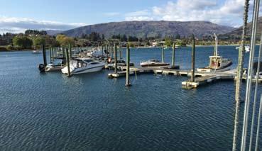
8 Cantilevered deck Piped spring water : A3 Petrol Entry gate Grebe bird rafts Shingle beach Bank with trees & weed species arrow footpath 2 lane road Residential apartments o breakwater Bank Marina arrow footpath used by cyclists Approximate lake edge Spring water seeps out of bank Informal boat trailer parking Rough grass bank Propsed new apartments Residential Ecology & Vegetation Access & Circulation Landuse Facilities & Recreation Lismore Road Willow Trees OTES 2 Grebe Bird rafts Small rafts attached to the piers of the marina to create nesting and roosting sites - increasing numbers. Informal arrangement with marina. Wanaka Springs Water Feature A community funded project water feature installed in 20, consisting of a rock and wood seating area and cascading water pools from a natural spring. 250m long lake edge; Little use; Poor access; Maintenance difficulties Bank Lakeside Road arrow footpath High density apartments Weeds & mix of tree species Timber deck Flat lawn Footpath Site Analysis Marina Area :000@A3 Bullock Creek delta Aggregating / accreting Willow 2 Formed spring head

9 Site Analysis Bullock Creek Area Bullock Creek delta : A3 Beach & pier Log cabin Car park Trees, planting & lawn 2 lane road Car park Path Shops Grass lawn Approximate lake edge Shingle banks Safety fence along creek arrow pinch point Hidden creek Connection to Lismore Rd from Monley Lane 2 OTES Log Cabin Log cabin currently used for boat hire and storage, with a small office space. Building is old and in average quality/repair. Playground This large children s playground ( Dinosaur Park ) can be accessed either off Ardmore Street or a pathway off Lakeside Road. It is renowned for its large dinosaur slide. Some rock erosion control Willow Worn path Old pier Deep water edge Willow Large parking area Poor access to water activities Poor drainage Boat hire Log cabin Courtyard Grid of oaks create framework Enclosed & dated Lawn Poor pedestrian links Cafe Dense screen planting arrow footpath Popular area for viewing & picnicking Helwick Street Bus parking Lane Shops Cafe Information sign Pedestrian areas Lawn BBQ Hand sculpture Mainly native shrub species screens views Open car dominated area Children s playground - enclosed 2 Ski shop Bullock Creek Toilets Bar Bank 2 distinct areas Lakeside Road Tall planting Big views Ramp up Large rear parking area Open area arrow footpath Screen planting Culverted creek disappears Bullock Creek Masonic Hall Poor pedestrian links ew temporary roundabout Well planted riverside Tidy formed walkway Sculpture Pedestrian Bridge Steps Civic Centre recessed Pedestrian Bridge Office / Retail Strong edge Library Monley Lane Wider open street Wanaka Hotel Art Centre Weak edge Ardmore Street Extensive parking Ecology & Vegetation Access & Circulation Landuse Facilities & Recreation Service Station


10 Site Analysis Town Centre Area Beach Informal walkway Car park Lawn Millennium Walkway 2 lane road : A3 Car park Path Shops Approximate lake edge Dominating carpark arrow footpath Mainly native shrub species screens views Poor connections Outside dining- Popular cafe Information panels Shallow edge Informal path Open lawn Good bathing beach Willow Trees Kerbed parking Large kowhai Trees Boat hire Ardmore Street Large kowhai Trees Poor links Grass lawn Big setbacks Wide terrace Recent quality development Older retail Good retail Lane Main street feel - enclosed intense quality shops Service lane Supermarket arrow Millennium Walkway Lawn Screen planting Very open Car parkingunusual layout Wide open berm Wide open space; Mix of trees; Poor structure Low barrier Pembroke Reserve Skate park Little tree planting Toilets Large & open dominating carpark Extensive hardscape Ecology & Vegetation Access & Circulation Landuse Facilities & Recreation

11 Site Analysis Main Beach Area : A3 OTES Beach Informal walkway Vegetation The vegetation is largely managed for recreation and amenity purposes, and is dominated by lawn and large exotic trees. The waterfront is lined with crack willow trees and other tree species including silver birch, oaks and poplars. Eucalyptus and kowhai grow in a park-like setting between the beach and the road. Grass area & informal parking Millennium Walkway 2 lane road & parking arrow grass strip Pembroke Reserve setback Shelter table Long section / open o trees Approximate lake edge Informal path Long skinny connection 50km/h zone with no traffic speed controls Parking directly on the beach Tiles missing Lawn Ardmore Street Very open Millennium Walkway Low barrier continues Mix of tree planting - small scale Cricket pitches arrow informal path along edge Shelter table Pembroke Reserve Large open lawn area Tall pines - landmark Ecology & Vegetation Access & Circulation Landuse Facilities & Recreation


12 Site Analysis South Beach Area Tall trees divide lakefront Parking Ecology & Vegetation Access & Circulation Landuse Facilities & Recreation Approximate lake edge Willows continue along front Very open - used for informal parking Poor pedestrian / cycle connections Ardmore Street Tall pines - Landmark Pembroke Reserve Lawn Informal path Character changes to be more enclosed by tall trees Willows Tall gums Toilets Wind break Clipped shelter belt - screens views Mcdougall Street Enclosed School route Lawn Large sports grounds Tall pines another windbreak : A3 Wanaka Recreational Reserve Beach Informal walkway Grass area & informal parking Millennium Walkway 2 lane road & parking Reserve setback Windbreak hedge Reserve


13 03 Site Analysis KEY FIDIGS Extensive lakefront edge and large scale retains potential for range of development options Celebrated open and informal edge to the lake Provision for continuous pedestrian access is poor and inconsistent 2 o monitoring of ecological value along lake edge between Marina and Bullock Creek delta water quality, habitat and diversity Lakefront is poorly linked to surrounds in all directions Dominance of unrestricted provision for motor vehicles Town centre is screened and cut off from lakefront General lack of facilities many in poor repair Little heritage dimension Lack of information and way finding

14 04 Constraints 280m 300m 320m Barrier to pedestrians Bottleneck - launching. Car parking and trailer congestion Medium to high density apartment area Car access arrow pathway on top of bank Marina getting too dominant? o breakwater Poor cycle access Little ecological value Runoff into lake not monitored and untreated Delta accreting Wet area Playground a barrier Wind Separate older town centre Wind Seasonal flooding Log cabin - long lease - divides lakefront Poor integration Screening Weak edge Gradient climbs Car orientated Wind Big open section; Visitors want access to lake front including camper vans. eeds to accommodate big influxes of crowds umber of crack willow trees Poor facilities Trees provid shade & shelter but obstruct views Gap in lake front Lack of facilities; o sense of heritage High speed road environment Pembroke Reserve Weak edges ewer town centre; Former residential Car park 280m Tall trees spatially enclose area; Separate section Big & open park; Little infrastructure; Few facilities Wide open views 300m Tall shady tree area Large open sports grounds with fields and tall wind breaks : A

15 05 Opportunities Integrate Management Plan for lake to monitor & safeguard lake health Passive Recreation Marina Zone Extend pedestrian promenade Larger public jetty Proposed extension to Yacht Club Extend Parking area Provide breakwater Commercial operators Additional berthage potential Cycle lane Marina Zone Bullock Creek Delta Ecological Zone Create rich ecological area with pedestrian boardwalk Extend the daylight celebration of Bullock Creek Bullock Creek Delta Ecological Zone CBD Lakefront Connection Better paths around playground Upgrade toilets Esplanade More trees; Wider footpath; Extend sculpture trail; Introduce signage & heritage; Introduce Maori presence & history; Re-organise parking Separate camper vans Provide a terminus destination Open up & create slow way; Minimise barriers; Street planting; Rationalise car parking Stronger pedestrian connections Slow traffic Contain edge Car parking potential ew pier Upgrade/move log cabin to open up & create a multi use space Pembroke Reserve Heavy vehicles Laneways Frame Broader footpath Integrate town centre and parking areas with waterfront - strengthen connections CBD Lakefront Connection Park Open Space Connection Create strategic link between 2 halves of town & sense of arrival / departure Extend garden development of Bullock Creek local identity to delta Old grid town form Park Open Space Connectio Active Recreation Develop different sections of lakefront - according to 204 Parks Management Plan Create continuous public realm & walkway : A
16 06 Key Moves - A 30 Year Plan Restore & develop ECOLOGY Provide continuous ACCESS Improve LADUSE Provide a range of FACILITIES Bullock Creek ecological enhancement ative revegetation planting along Marina edge Stormwater runoff treatment Lake health enhancement Fish & bird habitat creation along lake edge between Marina & Bullock Creek delta Continuous pedestrian / cycleway promenade around lakefront Traffic calming along Ardmore Street Pedestrian crossing thresholds Pedestrian priority between Dungarvon & Helwick Street Rationalise parking areas Lakefront linear park Create a series of precincts along the lakefront with defined use and character Create a new town green and plaza orientated between the lake and buildings Possibility to expand marina for additional berthage Enhance or create lakefront facilities Provide a new town pier Marina & Yacht Club upgrade Expand playground Lakefront Gardens Water sports Centre Interpretive signage Relocate parking to along edge of Reserve / Ardmore Street Heritage Trail Defined cycleway along Lakeside Road


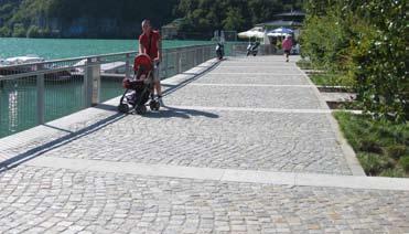


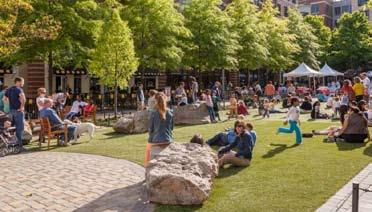
17 06 Key Moves - A 30 Year Plan IDICATIVE CHARACTER IMAGERY PROMEADE GARDES TOW PLAZA MARIA
LAKE WANAKA LAKEFRONT DEVELOPMENT PLAN. August 2016 RESET URBAN DESIGN. Garth Falconer
 LAKE WANAKA LAKEFRONT DEVELOPMENT PLAN August 2016 Garth Falconer RESET URBAN DESIGN LAKE WANAKA LAKEFRONT DEVELOPMENT PLAN August 2016 Project: Lake Wanaka Lakefront Development Plan Prepared for: Queenstown
H7 Open Space zones. (a) provide for the needs of the wider community as well as the needs of the community in which they are located;
 provide for the needs of the wider community as well as the needs of the community in which they are located;") H7. Open Space zones H7.1. Background The majority of land zoned as open space is vested in the Council or is owned by the Crown. However some areas zoned open space are privately owned. While the open
H7. Open Space zones H7.1. Background The majority of land zoned as open space is vested in the Council or is owned by the Crown. However some areas zoned open space are privately owned. While the open
Appendix H: Easement cross sections
 Appendix H: Easement cross sections SHARED PATH 1.5m FOOTPATH NATURE STRIP 7.3m CARRIAGEWAY 2.7m NATURE STRIP EXISTING PIPELINE 150mm DIA 5.0m (approx.) LOCAL ACCESS ROAD EXISTING PIPELINE 500mm DIA 2.7m
QLDC PROPOSED DISTRICT PLAN [PART FIVE] NOVEMBER 2017 OPEN SPACE & RECREATION
![QLDC PROPOSED DISTRICT PLAN [PART FIVE] NOVEMBER 2017 OPEN SPACE & RECREATION](/thumbs/89/100753530.jpg "QLDC PROPOSED DISTRICT PLAN [PART FIVE] NOVEMBER 2017 OPEN SPACE & RECREATION") 38 QLDC PROPOSED DISTRICT PLAN [PART FIVE] NOVEMBER 2017 38 O P E N S PA C E & R E C R E AT I O N OPEN SPACE & RECREATION QLDC PROPOSED DISTRICT PLAN [PART FIVE] NOVEMBER 2017 38 OPEN SPACE & RECREATION
38 QLDC PROPOSED DISTRICT PLAN [PART FIVE] NOVEMBER 2017 38 O P E N S PA C E & R E C R E AT I O N OPEN SPACE & RECREATION QLDC PROPOSED DISTRICT PLAN [PART FIVE] NOVEMBER 2017 38 OPEN SPACE & RECREATION
UNIVERSITY TOWN NEIGHBOURHOODS 5.2 ECO-CORRIDOR MELBOURNE CAMPUS MASTER PLAN 2014
 5.2 ECO-CORRIDOR 37 ECO-CORRIDOR EXISTING CONDITIONS & VISION NEIGHBOURHOOD VISION Investment in the Eco-corridor Neighbourhood will signify the University s commitment to supporting local ecology and
QUEENSTOWN LAKES DISTRICT COUNCIL SUBDIVISION DESIGN GUIDELINES
 Attachment C: Draft QLDC Subdivision Design Guidelines QUEENSTOWN LAKES DISTRICT COUNCIL DESIGN GUIDELINES A DESIGN GUIDE FOR AND DEVELOPMENT IN THE URBAN ZONES QUEENSTOWN OFFICE 10 Gorge Road Queenstown
project background relationship to the spit Guiding Principles Mooloolaba Spit Futures Plan (2009) Vision one
 Vision one") one project background relationship to the spit The Spit is an important part of Mooloolaba and a key contributor to the natural beauty of the town. The Spit is cherished by local residents and visitors
one project background relationship to the spit The Spit is an important part of Mooloolaba and a key contributor to the natural beauty of the town. The Spit is cherished by local residents and visitors
PART 5 : TEXTURE : PUBLIC DOMAIN CONCEPTS
 ART : TEXTURE : UBLIC DOMAIN CONCETS ENTRANCE TOWN CENTRE MASTERLAN 37 MARINE ARADE 3i 1a 3d 4a 3 6 3e 4b 4 3g 3c 4c 3f 3b 3a 1a 1 2a 2 3h WATERFRONT RECINCT WEST MASTERLAN TUGGERAH LAKE - CHANNEL The
Port Macquarie Town Centre Landscape Architects
 Port Macquarie Town Centre Town Green Master Plan Review Tract Landscape Architects Urban Designers Town Planners A review of the Town Green Master Plan Port Macquarie, New South Wales Prepared by Tract
Section 4 - Public Realm & Landscape proposals Landscape Masterplan. Section 4 52
 - Public Realm & Landscape proposals Landscape Masterplan 52 Proposed Masterplan - Green Infrastructure Strategy District Park 4.33 Ha to provide Passive and active recreation with a large play area which
10.0 Open Space and Public Realm
 10.0 Open Space and Public Realm 10.0 Open Space and Public Realm The Public Open Space System is comprised of: outdoor spaces available for public use that are either publicly owned (e.g., parks and
Four Big Ideas. Three Key Opportunities. Principles. Draft Place Making Master Plan. 1. The Foreshore 2. Green Links. 3.
 project background Four Big Ideas 1. The Healthy Thriving Place. An International Focus 3. Reclaiming Mooloolaba 4. The Resort Heart of the Coast In November 01 a big ideas workshop was held involving
GREENVALE CENTRAL PRECINCT STRUCTURE PLAN
 76 Conservation area boundary. Low Fence to exclude vehicles but allow pedestrian access Front boundary of allotment 5.0m MINIMUM SETBACK Path providing public access to dwellings fronting Conservation
Chairman and Members of the Planning and Development Committee. Thomas S. Mokrzycki, Commissioner of Planning and Building
 LA.09.TOR (Toronto) DATE: TO: FROM: SUBJECT: Chairman and Members of the Planning and Development Committee Thomas S. Mokrzycki, Commissioner of Planning and Building Central Waterfront Secondary Plan
Waterlily Playscape Committee Waterlily Playscape, Waterlily Park, Ocean Shores Draft Concept Plan. G Issue D 14/07/16
 Waterlily Playscape Committee Waterlily Playscape, Waterlily Park, Ocean Shores Draft Concept Plan Issue D 14/07/16 New two level wharf for fishing and interacting with waters edge (exact location to be
Tauranga City Centre Spatial Framework
 Tauranga City Centre Spatial Framework Stakeholder Engagement Workshop 15 October 2015 Project Design Team Beca & LandLAB Our team Henry Crothers (LandLab) Landscape Architect/Urban Designer Urban and
Background Information
 Background Information view at site entrance THE LONDON BOROUGH OF SUTTON As the strategic local authority the Council is working with a range of partners to take forward various development sites in Hackbridge.
REMARKABLES PARK ZONE
 .10 Remarkables Park Zone.10.1 Resources, Activities and Values The Remarkables Park Area comprises approximately 150 hectares of perimeter urban land in the vicinity of Frankton and occupies a strategic
Reconnecting to a Forgotten River St. Cloud MN. Aaron Hanson Design Design Thesis LA 572, Thesis, Spring 2012
 Reconnecting to a Forgotten River St. Cloud MN Aaron Hanson Design Design Thesis LA 572, Thesis, Spring 2012 site context 2.5 Miles Sartell St. Cloud to Fargo 170 Miles (2 hrs 45 mins) Hwy 10 infrastructure
PART AOTEA PRECINCT
 CONTENTS... PAGE AOTEA PRECINCT...4 14.5.1 INTRODUCTION...4 14.5.2 RESOURCE MANAGEMENT ISSUES...4 14.5.3 RESOURCE MANAGEMENT OBJECTIVES AND POLICIES... 4 14.5.4 RESOURCE MANAGEMENT STRATEGY...5 14.5.5
PUBLIC REALM STUDY AREA
 WELCOME PUBLIC REALM STUDY AREA WHAT IS PUBLIC REALM? Welcome to the Ballina Town Public Realm public consultation event. Mayo Council is in the process of producing a Public Realm Strategy for Ballina
CURL CURL BEACH LANDSCAPE DRAFT MASTERPLAN
 LANDSCAPE 03 04 05 07 06 08 LANDSCAPE KEY BENEFITS OPEN SPACE EXISTING = 25600m2 PROPOSED = 29000m2 NATURAL/LANDSCAPED AREA EXISTING = 36200m2 PROPOSED = 38450m2 PARKING SPACES MAIN CAR PARK EXISTING =
Welcome! HORSESHOE BAY PARK. Welcome!
 Welcome! HORSESHOE BAY PARK Welcome! Where are we in the process? Today we would like your input on how Horseshoe Bay Park can be upgraded to serve the community s needs better. CONSULT STAKEHOLDERS TAKE
Part 10 Town Centre Area Plans Toronto
 CONTENTS: 1 INTRODUCTION... 3 1.1 BACKGROUND... 3 1.2 EXISTING CHARACTER... 4 1.3 ENVIRONMENTAL CONSTRAINTS... 6 1.4 DESIRED FUTURE CHARACTER... 6 2 DEVELOPMENT CONTROLS... 8 2.1 BLOCK CONTROLS... 9 3
4.0 Open Space and Laneways
 4.0 Open Space and Laneways 4.1 Open Space Overview Existing open space network Currently there is a lack of public open space in the CBD - the only formal public space is Wachner Place, which is not functioning
Workshop #3 June 13, 2016
 Downtown Ocoee Master Plan Workshop #3 June 13, 2016 Our Team Our Team and Tonight s Goal Quick Recap: Why a Downtown Plan? How are we developing the plan? How can you still be involved? What s left to
QUEENSTOWN GARDENS DEVELOPMENT PLAN APRIL Attachment A
 Attachment A 1 APRIL 2018 PREPARED FOR QUEENSTOWN LAKES DISTRICT RESET URBAN COUNCIL DESIGN TABLE OF CONTENTS 01 INTRODUCTION 02 CONTEXT 03 ANALYSIS 04 DESIGN PRINCIPLES 05 2 01 INTRODUCTION A development
Terra Nova Rural Park Plan
 Terra Nova Rural Park Plan Part 1 Getting to know the land The Surrounding Area North Side Airport, River, Trail East Side - Residential West Side- Sturgeon Banks, West Dyke Trail South Side:Terra Nova
Proposed Pedestrian and Cycle Routes. Headland to Spit Great Ocean Walk and coastal path network* (Regional scale path)
") four strategies access and movement The access and movement strategy for the Master Plan aims to promote healthy, active and sustainable movements to and through Mooloolaba. Pedestrian and Cycle A lack
four strategies access and movement The access and movement strategy for the Master Plan aims to promote healthy, active and sustainable movements to and through Mooloolaba. Pedestrian and Cycle A lack
Community Design Guidelines. Port Wallace DRAFT
 Community Design Guidelines Port Wallace DRAFT Energy 1 2 3 Nature Movement Connections Built Form DRAFT Layout Energy 1 Nature Community Design Guidelines GREAT COMMUNITIES PROTECT, CELEBRATE, AND CONSERVE
VEHICULAR AND PEDESTRIAN CIRCULATION
 This perspective sketch communicates the intended character and quality of a proposed streetscape design. Locate benches near a major intersection where people tend to gather. Seating and lighting provide
Creating an integrated waterfront. Recommendations
 Creating an integrated waterfront Recommendations Railway Square Post Office + Shell Station Post Office Square Civic Square Ilot Green Wakefield St Wakefield St (Tory Cars) Wakefield St (New World Supermarket)
City of Rockingham. Local Management Practices, Costs and Strategic Coastal Planning
 City of Rockingham Local Management Practices, Costs and Strategic Coastal Planning Decision Making Process Considerations Climate Change Response Action Plan Ongoing observations/major Storm events Ongoing
QUEENSTOWN GARDENS DRAFT DEVELOPMENT PLAN CONSULTATION PRESENTATION OCTOBER 2017 RESET URBAN DESIGN
 RESET URBAN DESIGN 1 CONSULTATION PRESENTATION OCTOBER 2017 PREPARED FOR QUEENSTOWN LAKES DISTRICT RESET URBAN COUNCIL DESIGN TABLE OF CONTENTS 01 INTRODUCTION 02 CONTEXT 03 ANALYSIS 04 PLANNING PRINCIPLES
Overview Report. Proposed Development
 Overview Report Proposed Development the construction of a 1km cycle/pedestrian trail including a new footbridge, new car park and entrance road at Drumshanbo Lock and a new pedestrian/cycle road crossing,
Sub-committee on Harbour Plan Review of Harbour-front Enhancement Committee. Ninth Meeting
 Sub-committee on Harbour Plan Review of Harbour-front Enhancement Committee Ninth Meeting Date: 5 October 2005 Time: 3:30pm Venue: Conference Room 15/F, North Point Government Offices, 333 Java Road, North
I615. Westgate Precinct
 I615. Westgate Precinct I615.1. Precinct Description The Westgate Precinct is located approximately 18km west of the Auckland city centre. There are seven Sub-precincts in the Westgate Precinct: Sub-precinct
Memorial Business Park Site. Proposed Future Development. Design guidelines. August
 Memorial Business Park Site Proposed Future Development Design guidelines August 2014 www.designenvironment.co.nz 0064 3 358 3040 Contents 1.0 Background 1.1 Introduction 3 1.2 Objectives 4 2.0 Context
97 Lea Bridge Road, Leyton, E10 7QL London Borough of Waltham Forest December 2015
 97 Lea Bridge Road, Leyton, E10 7QL London Borough of Waltham Forest December 2015 Public Realm and Landscape Proposals LEA BRIDGE ROAD, WALTHAMSTOW Public Realm & Landscape Proposals BDP(90)RPT001 December
PORT OF VANCOUVER WATERFRONT DEVELOPMENT. Concept Development Plan City Center Redevelopment Authority April 20, 2017
 PORT OF VANCOUVER WATERFRONT DEVELOPMENT Concept Development Plan City Center Redevelopment Authority April 20, 2017 Port History PORT ESTABLISHED 1912 TERMINAL 1 ACQUIRED 1925 GWM SIGNS LEASE 1935 HARBOR
Wentworth Point July Community Information Session Feedback Summary
 Wentworth Point July Community Information Session Feedback Summary Introduction On Saturday, 28 July 2018, Landcom held a community information session from 11am to 1pm, at the Pulse Club, Wentworth Point,
8.0 Design and Form of Development 43/
 42/ 8.0 Design and Form of Development 43/ Rothwells Farm, Golborne/ Development Statement Figure 7. Site Constraints Key 44/ Site Boundary 360 Bus Route/Stops Existing Trees Underground Water Pipe Sensitive
Cold Lake Marina Master Plan
 Cold Lake Marina Master Plan Intro to Team Moffatt & Nichol is recognized throughout the world for our role in the revitalization and redevelopment of urban waterfronts, including the evolution of modern
March General enquiries: Web site:
 REDEVELOPMENT OF WILSON HOSPITAL FOR MITCHAM LOCAL CARE CENTRE Community Planning & Design Brief for Merton Clinical Commissioning Group and London Borough of Merton March 2016 1. Mitcham Cricket Green
LISMORE PARK, KELLY S FLAT, ALLENBY PARK, FAULKS TERRACE, DOMINI PARK & KENNEDY CRESCENT
 Attachment A: PROPOSED RESERVE MANAGEMENT PLAN FOR THE RECREATION RESERVES KNOWN AS: LISMORE PARK, KELLY S FLAT, ALLENBY PARK, FAULKS TERRACE, DOMINI PARK & KENNEDY CRESCENT WANAKA RECREATION RESERVES
Neighborhood Districts
 NEIGHBORHOOD DISTRICTS SEVEN MAIN DISTRICTS Neighborhood Districts While the Development Plan provides a broad-scale overview of the neighborhood, this section focuses on uses and relationships at the
2.0 Urban Design Concepts
 0 Urban Design Concepts Urban Design Concept diagrams The Waterfront Axis The Park Axis The Wharf Axis Waterfront Precincts 0.1 The Four Key Concepts: This Concept for the Wynyard Quarter establishes four
NORTH KUMUTOTO DESIGN BRIEF
 NORTH KUMUTOTO DESIGN BRIEF Adopted 22 November 2012 INTRODUCTION This design brief provides direction for development in the area known as North Kumutoto, the northern extent of the waterfront s Kumutoto
OPPORTUNITIES AND CONSTRAINTS - OXBOW PARK ENTRANCE AND PUT-IN
 OPPORTUNITIES AT OXBOW EXISTING WETLANDS Site is undeveloped and we can design a park that works well from the start. SAND BEACH Potential to eliminate invasive species. DEBRIS (CONCRETE, OLD CARS) VEGETATION
2. reimagine kings way undercroft as a community space
 2. reimagine kings way undercroft as a community space CLARENDON STREET CLARKE STREET QUEENS BRIDGE STREET MORAY STREET CITY ROAD BALSTON STREET BOYD KINGS WAY POWER STREET KAVANAGH WEST GATE FREEWAY Figure
URBAN DEVELOPMENT QLDC PROPOSED DISTRICT PLAN [PART TWO] AUGUST 2015
![URBAN DEVELOPMENT QLDC PROPOSED DISTRICT PLAN [PART TWO] AUGUST 2015](/thumbs/80/81778199.jpg "URBAN DEVELOPMENT QLDC PROPOSED DISTRICT PLAN [PART TWO] AUGUST 2015") 4 URBAN VLOPMNT U R P QLC PROPO ITRICT PLAN [PART TWO] AUGUT 2015 4 ur b an de v elop ment QLC ITRICT PLAN [PART TWO] AUGUT 2015 4 urban development 4 2 4.1 Purpose The purpose of this Chapter is to set
4 URBAN VLOPMNT U R P QLC PROPO ITRICT PLAN [PART TWO] AUGUT 2015 4 ur b an de v elop ment QLC ITRICT PLAN [PART TWO] AUGUT 2015 4 urban development 4 2 4.1 Purpose The purpose of this Chapter is to set
The Vision. Photo provided by The Minervini Group. 46 Vision, Objectives & Strategies
 Vision, Objectives & Strategies The is the public framework and guide for future development of the Grand Traverse Commons. The establishes public polices for infrastructure, the preservation of natural
Welcome. Community Consultation Meeting November 28, Review and discuss the Bathurst Quay Neighbourhood Plan Framework
 Welcome Community Consultation Meeting November 28, 2016 Why Are We Here Today? Review and discuss the Bathurst Quay Neighbourhood Plan Framework Review and discuss an Action Plan for Implementation Next
V. Gateways GATEWAYS / V-1
 V. GATEWAYS / V-1 Many of Chesapeake s gateways are located on highways and call for bold and attractive designs that motorists can understand, appreciate, and enjoy. can also take the form of natural
LAKEVIEW VILLAGE VISION & MASTERPLAN PRESENTATION TO CITY OF MISSISSAUGA. April 9, 2018
 LAKEVIEW VILLAGE VISION & MASTERPLAN PRESENTATION TO CITY OF MISSISSAUGA April 9, 2018 AGENDA Introduction Vision Plan Comparison The Big Moves Trail Connections Plan Overview Districts Conveyance Comparison
TAHOE CITY VISION PLAN June 2012
 TAHOE CITY VISION PLAN June 2012 Tahoe City Public Utility District North Lake Tahoe Resort Association Sustainable Community Advocates Agenda Process Overview Purpose TRPA Regional Plan Update Conversations
Ringsend & Irishtown Local Environmental Improvement Plan
 Ringsend & Irishtown Local Environmental Improvement Plan Study Area East Link Bridge St. Patrick s Boat Club Ringsend Technical Institute Stella Maris Boat Club St. Patrick s Church Ringsend Library Ringsend
PCAL Case Study Open Spaces: Blayney Heritage Park
 PCAL Case Study Open Spaces: Blayney Heritage Park Introduction Blayney Heritage Park is an area of high quality open space that offers a range of active and passive recreation facilities. The multi-purpose
chapter DESIGN GUIDELINES NEW RIVER MASTER PLAN REPORT
 chapter DESIGN GUIDELINES NEW RIVER MASTER PLAN REPORT .76 DESIGN GUIDELINES An Overview design guidelines NEW RIVER MASTER PLAN Design Guidelines can transform the image of a city. Specific, design-based
3.5 Principle 5/Response
 5 Principle 5/Response Existing street network Proposed street network Pedestrian street hierarchy Existing streets Existing Regional Arterial 4 Existing Street Network Existing and proposed streets Indicative
CHAPPLES PARK MASTER PLAN
 CHAPPLES PARK MASTER PLAN Presentation of Preliminary Development Options Public Open House #2 Wednesday November 2 nd, 2016 TONIGHT S AGENDA 1. Welcome & Introductions 2. Presentation by Sierra Planning
Colchester Northern Gateway Master Plan Vision Review Draft. July 2016
 Colchester Northern Gateway Master Plan Vision Review Draft July 2016 Contents Introduction 4 Context 8 Purpose of the Report 8 Strategic Position 9 Overview of the Process 11 2012 Master Plan Vision 12
Keystone Business Park Precinct Structure Plan North East Industrial Precinct. Part 2 Design Principles
 Keystone Business Park Precinct Structure Plan North East Industrial Precinct Part 2 Design Principles Context Issues Services Landform Issues Geotech and contamination Ecology Traffic and access Issues
T O W N O F H I G H R I V E R
 T O W N O F H I G H R I V E R o p e n s p a c e p l a n The Town of High River, 30 minutes South of Calgary, still retains much of its distinctive small town character and provides residents with a high
IMAGINE CLEARWATER. Community Workshop 3. November 2016
 IMAGINE CLEARWATER Community Workshop 3 November 2016 Imagine Clearwater has been a 6-month community-focused process to re-envision the downtown waterfront. VISIONING FRAMEWORK MASTER PLAN HOW CAN WE
Appendix A - Relief sought
 Appendix A - Relief sought Chapter 2 Definitions Definitions Tourism Activity (new) and Visitor Industry (new) The plan does not provide specific definition for tourism. The plan does introduce a new strategic
Preliminary Sketch Plan for Fort Hunter Park
 Preliminary Sketch Plan for Fort Hunter Park Public Presentation November 19, 2009 Dauphin County Parks and Recreation 100 Fort Hunter Road Harrisburg, PA 17110 (717) 599-5188 www.dauphinc.org THOMAS COMITTA
PRELIMINARY DESIGN + DEVELOPMENT PLAN
 WELCOME! To The Public Open House May 30 th, 2017 HARBOUR WEST PARKS Vision Project Overview The City s vision for Port Credit Harbour West Parks is to develop a vibrant waterfront destination that integrates
North Shore Trail. Council Meeting June 10, 2002
 North Shore Trail Council Meeting June 10, 2002 Process Guiding Principles Inventory and Analysis Preliminary Concepts (4) Final Concept Phasing Strategy Estimated Costs OVERVIEW Purpose: Prepare an overall
39 WALLACEVILLE STRUCTURE PLAN
 39 WALLACEVILLE STRUCTURE PLAN PRECINCT DESCRIPTIONS, INTENTIONS AND OUTCOMES Wallaceville Living Precinct Area A At approximately 13.4ha, this precinct is the largest precinct and the precinct provides
A CONCEPTUAL PROPOSAL BY THE UMDLOTI FORUM Representing the Umdloti Ratepayers and Residents Association and the emdloti UIP
 A CONCEPTUAL PROPOSAL BY THE UMDLOTI FORUM Representing the Umdloti Ratepayers and Residents Association and the emdloti UIP PRESENTATION STRUCTURE 1.0 Overview of Umdloti 2.0 Current challenges in Umdloti
WELCOME TO THE NEW WILTON PARK
 WELCOME TO THE NEW WILTON PARK VISION HISTORY OF WILTON PARK TOWARDS A PLANNING APPLICATION Our objective is to create a truly outstanding environment at Wilton Park. At the heart of our proposals is a
PLAN ELEMENTS WORKSHOP. April 5, 2016
 PLAN ELEMENTS WORKSHOP April 5, 2016 needs more housing. But there is no one-size fits-all solution. Every neighborhood has its own character. In some places, density is not only appropriate it is badly
STRATEGIC DIRECTION. QLDC PROPOSED DISTRICT PLAN [PART TWO] DECISIONS VERSION 3 strategic direction
![STRATEGIC DIRECTION. QLDC PROPOSED DISTRICT PLAN [PART TWO] DECISIONS VERSION 3 strategic direction](/thumbs/79/79711764.jpg "STRATEGIC DIRECTION. QLDC PROPOSED DISTRICT PLAN [PART TWO] DECISIONS VERSION 3 strategic direction") 3 STRATEGIC DIRECTION QLDC PROPOSED DISTRICT PLAN [PART TWO] DECISIONS VERSION 3 strategic direction QLDC DISTRICT PLAN [PART TWO] AUGUST 2015 3 strategic direction 3.1 Purpose This chapter sets out the
3 STRATEGIC DIRECTION QLDC PROPOSED DISTRICT PLAN [PART TWO] DECISIONS VERSION 3 strategic direction QLDC DISTRICT PLAN [PART TWO] AUGUST 2015 3 strategic direction 3.1 Purpose This chapter sets out the
Public Workshop 2 December 11, 2014 OLIN
 Public Workshop 2 December 11, 2014 OLIN TRIPLE IMAGE PANORAMA A NEW VISION FOR THE RIVERFRONT PROMENADE Burlington s Riverfront has historically been a defining character of the City s identity. This
ELLIOTT HEADS STRUCTURE PLAN
 ELLIOTT HEADS STRUCTURE PLAN BACKGROUND This report has been prepared to provide an overview of the land that has been included in the Urban Footprint within the Wide Bay Burnett Regional Plan, September
Making the case for Sustainable Transport Project Potential
 Making the case for Sustainable Transport Project Potential The Structural Investment Fund (SIF) Strategy for Greater Lincolnshire identifies the barriers to growth identified by having poor transport
Monte Cecilia Park DRAFT CONCEPT PLAN FEBRUARY 2015 AUCKLAND COUNCIL
 Monte Cecilia Park DRAFT CONCEPT PLAN FEBRUARY 2015 AUCKLAND COUNCIL 1 Site analysis and concept 1.1 Location Site Extent MT ALBERT RD HILLSBOROUGH RD BUDOCK RD MONTE CECILIA PARK KORMA RD HERD RD Figure
8.2 Sector 2 Kelburn Park
 8.2 Sector 2 Kelburn Park Kelburn Park, near Victoria University 8.2.1 Character and use Kelburn Park is a sector of the Town Belt, of a scale and character more like a suburban park. However, the woodland
Mount Maunganui North. Neighbourhood Plan
 Mount Maunganui North Neighbourhood Plan March 2002 Acknowledgements The time and energy provided to this neighbourhood planning process by representatives of the Mount Maunganui Progressive Association,
PHASE ONE. A summary report: What the community told Alcoa during Phase One of the community engagement program for Point Henry 575.
 PHASE ONE A summary report: What the community told Alcoa during Phase One of the community engagement program for Point Henry 575. DECEMBER 2015 FEBRUARY 2016 INTRODUCTION In 2014 Alcoa closed its Point
Sawtell Town Centre Development Control Plan
 Sawtell Town Centre Development Control Plan ABN 79 126 214 487 CONTENTS INTRODUCTION... 1 PREAMBLE... 1 HOW TO USE THIS DCP... 1 LAND TO WHICH THIS PLAN APPLIES... 1 MASTERPLAN... 2 VISION... 2 CHARACTER
Shared Principles and Emerging Plan Directions
 Shared Principles and Emerging Plan Directions Introduction Since the Fairfield Neighbourhood planning process launched in June 2016, we have heard from many residents, businesses, groups and other people
BRADENTON RIVERWALK EXPANSION MASTER PLAN
 BRADENTON RIVERWALK EXPANSION MASTER PLAN INTRODUCTION & AGENDA Process Update Community Engagement Summary Center for Active Design (CfAD) Recommendations Context and Existing Conditions Master Plan Alternatives
Courthouse Square Planning & Urban Design Study. Courthouse Square Working Group #13 October 15, 2014
 Courthouse Square Planning & Urban Design Study Courthouse Square Working Group #13 October 15, 2014 1 Courthouse Square Process Working Group Community Courthouse Square Advisory Groups & Civic Associations
Proposed Southland District Plan 2012 Appeal Version October 2016
 S e c t i o n 3. 5 - F i o r d l a n d / R a k i u r a Z o n e The Fiordland/Rakiura Zone encompasses the Fiordland and Rakiura National Parks and part of Mt Aspiring National Park. It also includes areas
DRAFT. Waterfronts and Open Spaces. 10 The Riverfront Open Space System
 CHAPTER 4 Waterfronts and Open Spaces 10 The Riverfront Open Space System 12 Planned, proposed and envisioned riverfront recommendations. Figure 4.3.23 The riverfront will become a major new public amenity
PHASE 3-4 PARKS SOUTH PARK AND CHANNEL PARK
 PHASE 3-4 PARKS SOUTH PARK AND CHANNEL PARK Sheet List L1.0 L2.0 L3.0 L4.0 L5.0 L6.0 L7.0 L8.0 L9.0 L10.0 L11.0 L12.0 L13.0 L14.0 L15.0 L16.0 L17.0 L18.0 L19.0 L20.0 L21.0 L22.0 Cover Open Space Context
Highland Falls Waterfront Redevelopment Feasibility Study Village Board Meeting March 20, 2017
 Village Board Meeting March 20, 2017 Agenda I. Public Meeting #1 Visioning Summary II. Public Meeting #2 Comment Summary III. IV. IV. Case Study: Milton Train Station Schematic Design Concepts Schedule/Next
MARINA MARKET & WATERFRONT DEVELOPMENT STUDY PORT ARANSAS, TEXAS
 MARINA MARKET & WATERFRONT DEVELOPMENT STUDY PORT ARANSAS, TEXAS FEBRUARY 2015 PRESENTATION OUTLINE 1 2 3 4 5 6 7 REGIONAL POSITIONING SITE IMPRESSIONS PLANNING & DESIGN PRINCIPLES EXISTING IMPROVEMENTS
Preci nct P l ans Figure 56 Campus Aerial Photo, 2008 CAL STATE EAST BAY, HAYWARD CAMPUS MASTER PLAN
 9 Precinct Plans This section contains a detailed discussion of the planning and design concepts for specific areas or precincts of the Cal State East Bay Hayward campus. The Precinct Plans pertain to
Small Towns Consultation Gordon Community Conversation 26 February 2015 Meeting Notes Total Community Attendees - 44
 Small Towns Consultation Gordon Community Conversation 26 February 2015 Meeting Notes Total Community Attendees - 44 The following is the information we received at the Community Conversation. Community
Response to the London Bridge Area Vision and Site Allocations within the New Southwark Plan
 1 Melior Place London SE1 3SZ 020 7407 4701 teamlondonbridge.co.uk info@teamlondonbridge.co.uk 28 April 2017 Response to the London Bridge Area Vision and Site Allocations within the New Southwark Plan
Bayswater Town Centre Structure Plan. Visioning Workshop. October 2016
 Bayswater Town Centre Structure Plan Visioning Workshop October 2016 Bayswater Town Centre Structure Plan Visioning Workshop The Project Process 1 2 3 4 5 6 7 Background Research & Analysis Establish Community
SQUAMISH 2010 AND BEYOND COMMUNITY VISION
 Our plan has been imagined and created to be both pragmatic and visionary. At the core of the strategy is a consideration of the highway s role and its impact on the community. First and foremost in creating
Somers Point Master Plan
 Somers Point Master Plan Progress Report and Public Meeting August 20, 2014 Master Plan Reexamination Municipal Land Use Law require that all municipalities reexamine their master plan every ten years.
TONIGHT S MEETING DRAFT SUMMARY REPORT CAPE WOOLAMAI COASTAL RESERVES MASTER PLAN PHILLIP ISLAND SOUTH AND NORTH COAST KEY AREA PLAN OCTOBER 2014
 TONIGHT S MEETING Phillip Island Nature Parks and Bass Coast Shire Council have partnered to achieve a comprehensive and integrated master plan for the safe use and management of Cape Woolamai Coastal
ROSENTHAL CARPARK LIFE BETWEEN BUILDINGS IN LANE COVE
 south square Life between buildings includes all the very different activities people engage in when they use common city space; purposeful walks from place to place, promenades, short stops, longer stays,
Throughout. square. (Crystal City Vision Plan 2050)
") 1: Terms related to the PSMP document 1 public space (see also public realm, civic space) An open space designated on the regulating plan, accessible to all, including Plazas, Mini Parks, and Neighborhoods
1: Terms related to the PSMP document 1 public space (see also public realm, civic space) An open space designated on the regulating plan, accessible to all, including Plazas, Mini Parks, and Neighborhoods
Workshop 3. City of Burlington Waterfront Hotel Planning Study. September 14, The Planning Partnership
 Workshop 3 City of Burlington Waterfront Hotel Planning Study September 14, 2017 The Planning Partnership The Waterfront Hotel Planning Study 01 The Brant & Lakeshore Planning Study will establish a Strategic