R I V E R F R O N T P L A N
|
|
|
- Isabel Elliott
- 6 years ago
- Views:
Transcription
1 NEW KENSINGTON RIVERFRONT PLAN FEBRUARY 2008 R I V E R F R O N T P L A N NEW KENSINGTON
2
3 CONTENTS INTRODUCTION Purpose of the Plan Process Background DEVELOPMENT FRAMEWORK Framework Plan Development Guidelines GATEWAY CONCEPTS Access Parks Streetscapes IMPLEMENTATION Stakeholders and Partners Potential Funding Opportunities Short-Term Activities Implementation Matrix

4 MCGUIRE INDUSTRIAL PARK UPPER KENSINGTON JUNIATA WEST KENSINGTON OLDE KENSINGTON KENSINGTON HARROWGATE LOWER KENSINGTON FISHTOWN Aramingo Ave. Lehigh Ave. RICHMOND Allegheny Ave. Girard Ave. I-95 Spring Garden St. Delaware Ave. I-95 PENN TREATY PARK PORT RICHMOND PULASKI PARK Delaware Ave. Ben Franklin Bridge Betsy Ross Bridge
5 This plan is the result of a year-long process that involved the communities of Fishtown, Kensington, and Port Richmond; state and local agencies; the New Kensington Community Development Corporation (NKCDC) and Wallace Roberts & Todd, LLC (WRT). Rooted in a public outreach initiative and guided by a broad task force, the New Kensington Riverfront Plan provides a flexible framework for development along, and public access to, the Delaware River. Funded by the PA Department of Conservation and Natural Resources (DCNR) in cooperation with the Pennsylvania Environmental Council, the plan focuses on the balance between development and open space, with three major plan elements: 1) Development Framework 2) Gateway Concepts 3) Implementation. 1) Development Framework 2) Gateway Concepts 3) Implementation. The first two plan elements will enable NKCDC and the community to work with the city to shape future development while ensuring access to natural resources. The third plan element focuses on partnership and funding opportunities to accomplish the first two plan elements. INTRODUCTION 3

6 PURPOSE OF THIS PLAN The purpose of this plan is to expand upon and update the neighborhood plan prepared by WRT in 2003, in reaction to current development pressures, state infrastructure investments, and opportunities to coordinate with other planning efforts. Specifically, NKCDC finds itself in the midst of development pressures moving north from Center City, other planning efforts in and around the NKCDC service area, and the broader planning efforts that began with the 2001 North Delaware Riverfront Plan and continued most recently with Penn Praxis Civic Vision for the Central Delaware. NKCDC participated in the year-long planning process conducted by PennPraxis that resulted in a development framework that is the basis for NKCDC s riverfront plan in this document. Because of NKCDC s involvement in that inclusive and ongoing effort, the development framework is viewed as the basis for future dialogue with the city and developers. The purpose of this plan is to provide a flexible framework that is focused on implementation, particularly in light of the zoning reform effort currently underway and endorsed by the city administration. In order to build consensus for the plan and to set an implementation strategy, a Riverfront Task Force was created that includes community organizations, stakeholders, and future project funders. The broad membership of this guiding body is an attempt to ensure that the effort will be followed through to implementation. 4 INTRODUCTION
7 PROCESS The staff of NKCDC and WRT worked closely together to develop New Kensington Riverfront Task Force: a scope of services that leveraged WRT s work with PennPraxis on the Civic Vision for the Central Delaware. In January 2007, NKCDC contracted with WRT to carry out the work. A broad Riverfront Task Force comprised of local and State agencies, community organizations, and residents from NKCDC neighborhoods was formed to guide the planning process. This group was charged with reviewing WRT s work and vetting the plan recommendations. Brian Abernathy Councilman DiCicco s Office Glen Abrams Philadelphia Water Department Office of Watersheds Win Akeley Friends of Penn Treaty Park Jeremy Beaudry Neighbors Allied for the Best Riverfront Theresa Costello Port Richmond Community Group Spencer Finch Pennsylvania Environmental Council Ben Ginsberg Center City District Mike Greenle PennPraxis Bridget Keegan PennPraxis Laura Lanza Resident Chris Linn Delaware Valley Regional Planning Commission Kathleen Lunn PA Department of Community and Economic Development Jim Mancinelli Friends of Penn Treaty Park Nancy Martino Friends of Penn Treaty Park Barbara McCabe Philadelphia Recreation Department Joe McNulty New Kensington CDC Mike O Brien Pennsylvania House of Representatives David Ortiz Philadelphia City Planning Commission Christine Rabe Resident Shawn Rairigh Neighbors Allied for the Best Riverfront Joan Reilly Pennsylvania Horticultural Society M. Simone Resident Patrick Starr Pennsylvania Environmental Council Sandy Salzman New Kensington CDC Shanta Schachter New Kensington CDC Sarah Thorp Delaware River City Corporation Carolyn Wallis Pennsylvania Department of Conservation and Natural Resources Dennis Winters Clean Air Council Maryann Womelsdorf New Kensington CDC INTRODUCTION 5
8 1. Data Collection and An Outline 2. Riverfront Best present the possibilities for of riverfront best practice Force, WRT and NKCDC set 3) The character of the Coordination with Other Practices Presentations the Delaware Riverfront case studies, and the plan and prioritized the goals of development in the Planning Efforts Parallel to the Riverfront Task through case studies and framework developed con- the development framework. riverfront area; and WRT collected data from the NKCDC and coordinated with other waterfront planning efforts to provide the basis for the development of the riverfront plan. Key to this coordination was the concurrent PennPraxis riverfront planning effort, which was also led by WRT and involved surrounding communities, such as Northern Liberties Neighborhood Association. Force review was a community outreach and engagement process designed by NKCDC to support the planning effort. This program included an initial series of neighborhood meetings that reviewed locally relevant riverfront issues and national best practices to facilitate community comment and direction. A PowerPoint slide show was given to visually best practices from other urban waterfronts. 3. Community Design Workshop: Draw Me a River NKCDC and WRT facilitated a community workshop on June 2nd, 2007, that engaged a broad neighborhood constituency. The workshop began with a review of existing conditions on the Delaware River, a presentation currently with the PennPraxis plan. The community then participated in break-out sessions that explored possibilities for riverfront gateway projects. The work of the break-out sessions was summarized at the workshop and in a report document. 4. Development Framework, Goals, and Priorities Through the Riverfront Task The four primary areas of 4) The integration of concern defined were: environmental, historic, of the 1) The community s definition and cultural identity of public access to and along programs. the river; With the help of the Riverfront Task Force, a sum- 2) The characteristics of the greenway and the river s edge; mary matrix was created that 6 INTRODUCTION
9 includes jurisdictional and tasked responsibilities of various entities. Land Use Concept Circulation + Access Plan Open Space Concept The components of the Framework Plan were vetted with the community and 6. Development Guidelines WRT prepared general development guidelines based on the general urban design principles recommended in the Civic Vision Project 5. Framework Plan A NKCDC framework plan was developed with three framework components that relate to the PennPraxis plan: the Riverfront Task Force and served as the basis for development guidelines and gateway concept plans. for the Central Delaware prepared as part of a civic engagement process. The guidelines were then extended and tailored to the input of the residents of the NKCDC service area. These guidelines for new development interpret the land use concept and are seen as the basis for a dialogue with the city as zoning reform moves forward. In the short-term, these guidelines will serve the community in their discussions with developers and the city when addressing basic urban design concepts such as arrangement of land uses, massing, scale, interface between buildings and surrounding streets and parks, etc. 7. Gateway Projects Concept Plans Working with the Riverfront Task Force and NKCDC, WRT developed concept plans for public access and open space. These concept plans set early action projects to seek funding for implementation and are categorized into three types, Access, Parks and Key Streets: Access Lehigh Viaduct Frankford Creek Parks Penn Treaty Park Gunner s Run Park Pulaski Park Key Streets Frankford Avenue Columbia Avenue 8. Plan Documents Final documentation is provided to NKCDC in the form of a report, digital presentation, and poster. Process INTRODUCTION 7


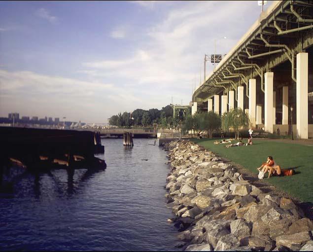
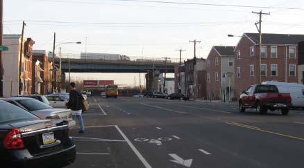
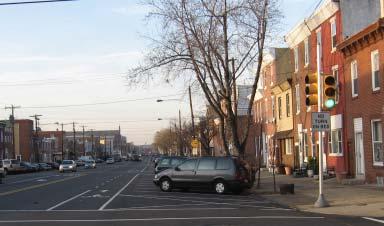
10 BACKGROUND: DEVELOPMENT PRESSURES In 2007, New Kensington Community Development Corporation (NKCDC) and the neighborhoods within its service area found themselves facing development pressures that ranged from state-initiated casino sites to high-density housing development proposals. With three of the five proposed casino sites in the neighborhood, thousands of units of high-rise housing on the drawing boards, the Philadelphia housing market going strong even as the national market softened, and a permissive zoning environment, interest in NKCDC riverfront property reached a fever not seen since the turn of the 20th century. With only hints of a housing recession surfacing in the final months of 2007 and with the SugarHouse casino site moving slowly into the city approval process, the neighborhood groups in Fishtown continued to be engaged by development interests and pressures. Clockwise from top left: New Kensington neighborhoods from a Waterfront Square tower at the river s edge; New commercial and high-rise development proposed along the river at Spring Garden Street; View of riverfront from right-ofway at Frankford Avenue and Delaware Avenue; Philadelphia of Today by McFetridge, 1887, showing Gunner s Run Creek along the Aramingo Avenue alignment. 8 INTRODUCTION

11 DEVELOPMENT PRESSURES Philadelphia s Delaware Riverfront is facing many kinds of development pressures. New Kensington s riverfront is experiencing all of them and offers very little public access to the river. Caption title Caption body Development Proposal Zone Casino Site Designations Industrial Development Interests Riverfront Areas Currently Accessible by Public 100-Year Floodplain 500-Year Floodplain Riparian Zone Combined Sewer Outfall (Approximate Location) INTRODUCTION 9
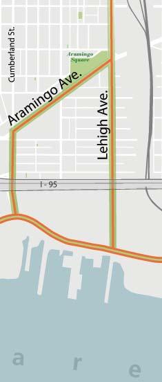
12 BACKGROUND: INTERSTATE 95 RECONSTRUCTION At the same time that development of riverfront property is the Through the PennPraxis planning effort, WRT worked with focus of local government, neighborhood groups, and property PennDOT, their planners and engineers, the Philadelphia Water owners, the Pennsylvania Department of Transportation (PennDOT) Department (PWD) Office of Watersheds, and the city to envision is finalizing plans to rebuild Interstate 95 in the NKCDC service environmental and connectivity enhancements in the reconstruction effort. A review of historical mapping provided by the area. The rebuild of this section will begin in 2008 and last for eight years. While one purpose of this Federal Highway Administration-funded reconstruction project is to better accommo- location of an historic stream and canal, Gunner s Run, that was Philadelphia City Planning Commission (PCPC) identified the date the increasing through traffic volume from I-95 to the Vine the basis for the conceptual design of a stormwater park that Street Expressway (I-676), a significant focus of the project is the connects Aramingo and Girard Avenues to the river at Dyott reconfiguration of the Girard Avenue interchange. The planned Street. reconfiguration is an opportunity to improve street connections between neighborhood and riverfront property and extend Delaware Avenue through to Cumberland Street as a major ground- remaining historic Cramp Shipyard building. While the owner The new ramp locations require demolition of the primary level investment. of the property has moved forward on development plans for the property, PennDOT is in the process of acquiring all land The new ramp configuration for the interchange centers access necessary for the reconstruction project. to and from northbound I-95 at the intersection of Schirra Drive and Delaware Avenue. This reconfiguration includes improved When completed in 2016, the new ramps will privilege the riverfront property along Delaware Avenue from Aramingo Avenue pedestrian access along Aramingo Avenue and stormwater management parks. to Cumberland Street with increased highway access, which will alter the real estate value of these parcels. Opposite, top: Girard Interchange Environmental and Connectivity Enhancements In conjunction with improvements to the Girard Interchange, PennDOT can construct a pedestrian-accessible stormwater park that will serve as a community amenity and manage stormwater run-off. Opposite, bottom left: Anticipated Interstate 95 Reconstruction Schedule PennDOT s planned schedule for the reconstruction of I-95 along the Delaware River includes the widening and realignment of the viaduct in the north and the complete replacement of the Center City section. Opposite, bottom right: Girard Avenue Interchange PennDOT s design for the reconstruction of the Girard Avenue Interchange, which was scheduled to begin in January INTRODUCTION
 Open Space under I-95 Conversion of Highway Embankment to Structure")


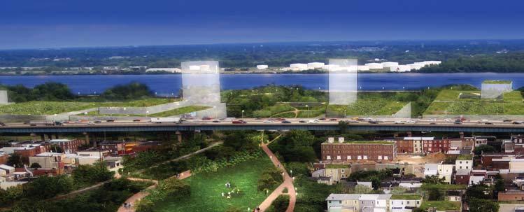
13 Park-like Open Space under Girard Interchange Stormwater Run-off Infiltration (8 acre-feet) Open Space under I-95 Conversion of Highway Embankment to Structure Highway On/Off Ramps (at-grade barriers) Local, At-Grade Road (under interchange) Proposed At-Grade Local Road Reconfiguration Pedestrian Circulation Concept Significant Pedestrian Portals under I : Full Reconstruction, Current Schedule : Superstructure Replacement, Schedule Based on Cap Structure Condition INTRODUCTION 11
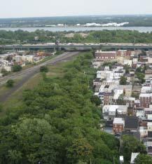
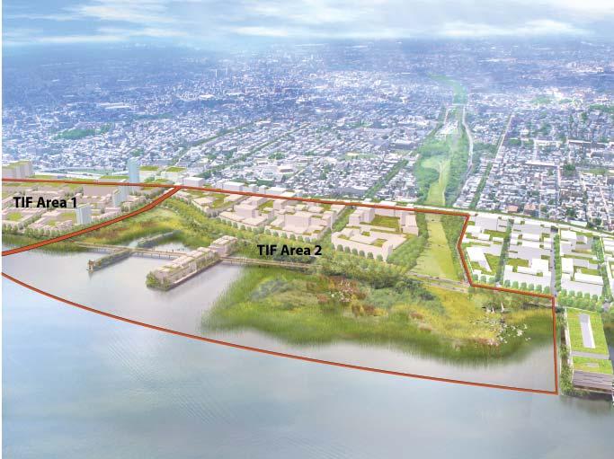
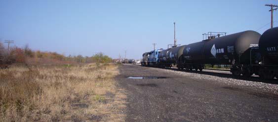
14 BACKGROUND: CRAMP & PORT RICHMOND SHIPYARDS Other development interests include plans for port-related uses PennPraxis effort in determining the site s market potential and from the Girard Avenue interchange north through the property investigating a tax increment financing (TIF) strategy to finance associated with the Tioga Marine Terminal. Once the Pinnacle public improvements on the portion of the Conrail property that Casino site was not selected as one of the two Philadelphia sites, PIDC was interested in. the ownership interests in the Cramp Shipyard area have been seeking other development opportunities in anticipation of the The northern section of the Conrail property is occupied by improved access from I-95. active industrial uses under a lease agreement and like the Tioga Marine Terminal is currently prime industrial land due to its An area of significance is the Conrail property between Cumberland Street and Allegheny Avenue. The Philadelphia Industrial following the active rail line from Richmond Street to Allegheny easy rail and highway access. A portion of the Conrail property Development Corporation (PIDC) has been in discussions with Avenue near Pulaski Park is also being leased as part of the Conrail and its owner companies Norfolk Southern Railway temporary access plan for PennDOT s reconfiguration of the and CSX Transportation for the sale and development of a Girard Avenue interchange. The term of the lease is 20 years. warehouse and distribution center in the area south of the current rail line. The Conrail site is also prominently featured in another concurrent planning effort. GreenPlan Philadelphia, a city-wide As part of the PennPraxis planning effort, PIDC was contacted vision for open space, developed by the City of Philadelphia and to discuss future, more intensive use of the land and the acreage requirements for the subdivision of land for different types and trail creation. As a park with trails, the viaduct could serve WRT, identifies the viaduct as a notable opportunity for park of uses. Economics Research Associates, Inc. (ERA), a market and several highly underserved communities and connect them to the economics consultant firm out of Washington, DC, assisted the riverfront. Clockwise from top left: The Lehigh Viaduct today with I-95 and the Delaware River in the background. ERA s Economic Analysis Study for the Civic Vision for the Central Delaware investigated a TIF strategy to fi nance public improvements in the Port Richmond Rail Yard area. The Lehigh Viaduct by Green- Plan Philadelphia is envisioned as an opportunity for park and trail creation and as a major connection to the riverfront. An aerial view of the privately-owned riverfront south of the Conrail lands with the historic Cramp Shipyard building in the foreground. (See TIF Area 1 in the ERA Analysis Study diagram). 12 INTRODUCTION
15 INTRODUCTION 13
16 BACKGROUND: TIOGA MARINE TERMINAL The area north of Allegheny Avenue has seen little change in the past decade, but talks of a bio-mass energy facility at the Tioga Marine Terminal occurred in the past year. The area from Allegheny Avenue to the Frankford Creek was part of a study commissioned by the Philadelphia City Planning Commission that was completed in 2001, titled Renovating Post-Industrial Landscapes: The North Delaware Riverfront. The recommendations of the study included restoration of the banks of the Frankford Creek and employing best practices for renewable energy and water treatment at the site of the PECO electrical plant, Philadelphia Gas Works, and the Philadelphia Water and Control Plant. The plan proposes a new public park that integrates a wind and solar panel farm as well as constructed wetlands for water treatment. To date, there has been no implementation for this area of the plan. 14 INTRODUCTION


17 A Vision of Tioga Marine Terminal Possible new infra-scapes south of Bridesburg at the Philadelphia Water Treatment Central Facility, the Richmond PECO Energy Facility, and Philadelphia Gas Works plant. Diagram by Field Operations. Tioga Marine Terminal The tank farms of the Tioga Marine Terminal as seen from the street, and the Terminal as seen from above. INTRODUCTION 15
18 DEVELOPMENT FRAMEWORK The development framework envisioned by NKCDC and the Riverfront Task Force is a flexible one that can accommodate changes in market conditions, but provides access and open space amenities that will serve the riverfront neighborhoods as well as the development of private property. The primary goals of the framework are: Public access to and along the river. Defined character of the greenway and the river s edge. Integration of environmental, historic, and cultural program and identity. Defined character of the development in the riverfront area. The development framework is presented in two sections: A Framework Plan and Development Guidelines 16

19 THE FRAMEWORK PLAN The Framework Plan was developed in concert with the PennPraxis Civic Vision for the Central Delaware with three framework components, land use, circulation and access, and open space. The components of the Framework Plan were vetted with the community and the Riverfront Task Force and serve as the basis for development guidelines and gateway concept plans. Land Use Concept Circulation and Access Concept Open Space Concept DEVELOPMENT FRAMEWORK 17
20 LAND USE CONCEPT The general concept is a gradation of residential mix starting at Spring Garden with the most residential use to Allegheny Avenue with mostly job-producing uses commercial and industrial uses. The Tioga Marina Terminal area from Allegheny Avenue to the Frankford Creek is assumed to remain industrial. As imagined in the Civic Vision for the Central Delaware and the preceding North Delaware Master Plan, the industrial uses should look to future technologies both alternative energy production(bio-fuel, solar, and wind) and alternative water treatment related to the existing plant and surrounding land. The residential mix is shown in three grades or zones but does not address height or specific density by parcel or block. The specifics of land use and height should be addressed in the communities engagement with the City s zoning reform initiative. In terms of intensity of use the concept assumes that a floor area ratio (FAR) of 4 is established for the entire area. The current zoning calculates FAR to include water rights and exclude parking, resulting in much higher FARs sometimes twice as high. This plan recommends revising the FAR calculation to take these factors into consideration and reducing the potential for overdeveloping specific sites. Mixed Use 1 With close proximity to Center City and adjacencies to booming residential neighborhoods of Old City, Northern Liberties, and Fishtown, this zone is seen as the greatest opportunity to build residential density to support transit service improvements and expanded retail services. Proposed build out in this area already leans toward residential intensity, so future discussions with the city on zoning reform should focus on Mixed Use 2 With proximity to the Girard Avenue I-95 Interchange, access to the Girard Avenue Trolley line, and strip retail along Aramingo Avenue, the market potential is for retail and commercial services. This potential was identified through the Central Delaware planning process and also identified the need to mix residential uses with retail use in a neighborhood center that would also serve as a regional retail destination. Mixed Use 3 With PIDC and Conrail in discussions about developing portions of this area for the creation of jobs, this area is seen as mostly businesses that integrate physically and economically with the adjacent neighborhoods. Like the industrial zone at the Tioga Marine Terminal the intent for this area is to attract businesses that focus on future technologies in energy, sustainable manufacturing, medicine, communications, etc. the inclusion of retail services. Brief descriptions of the three mixed-use zones shown in the diagram on the facing page: 18 DEVELOPMENT FRAMEWORK
21 LAND USE CONCEPT Mixed Use 1 Mixed Use 2 Mixed Use 3 Industrial Public Greenway DEVELOPMENT FRAMEWORK 19
22 CIRCULATION AND ACCESS CONCEPT The circulation and access plan is an outgrowth of WRT s work with PennPraxis in collaboration with PCPC, PennDOT, their consultants (URS and Glatting Jackson), and review with the Riverfront Task Force. The extension of Delaware Avenue as a riverfront boulevard and the adoption of a grid of streets are the central concepts of this plan. Also key to the access concept is the adoption of green streets by the city and neighborhood groups. The identification of these streets is based on the dimension of the street right-ofway, connection of neighborhood parks to Delaware Boulevard and/or the river, and the ability to accommodate state-of-the-art stormwater management in the streetscape. Opportunities vary among the different green streets but through WRT s work with the Riverfront Task Force, GreenPlan, and the Central Delaware, the Office of Watersheds at PWD has been involved in the identification of specific strategies. The following streets have been identified through this planning process as potential green streets: Spring Garden, Frankford, Columbia, Cumberland, Lehigh, Anne, Allegheny, Castor, and Lewis. Delaware Boulevard is part of this green streets concept, and is supported by primary and secondary streets, as shown in the Circulation and Access Concept diagram on the facing page. The intent of the primary streets is two-fold: Adding Value The adoption of a street plan has the power to add value to the properties beyond the the boulevard frontage and the current right-of-ways. As the city has done in the past through its charter, the street plan can be acted on at the time of development of the site. At this point, the task at hand is determining the ownership structure and value of these streets in relationship to development value. Managing Traffic An incremental approach to accommodating increased automobile traffic results in lane-widening and the degradation of the pedestrian environment. Adopting a framework of primary and secondary streets allows for a balanced approach to traffic management as development occurs across the district. The secondary streets provide the framework for another level of support to development that relate to use, intensity, and service. In the diagram on the facing page, these streets are shown in a lighter shade of orange to indicate that the use and location of this system is flexible. For instance, the use of the secondary streets is appropriate if lower intensity residential is proposed for a specific development block defined by the primary streets. Another example is the interim development of industrial uses that preserve the right-of-ways through zoning for future redevelopment purposes as the market shifts. Related to access for building uses, the secondary streets might be used as service alleys, like Ludlow, Sansom, and Delancey Streets do in different parts of Center City. 20 DEVELOPMENT FRAMEWORK
23 CIRCULATION AND ACCESS CONCEPT Boulevard Green Street Primary Street Secondary Street DEVELOPMENT FRAMEWORK 21
24 OPEN SPACE CONCEPT The open space concept responds to input from the Fishtown, Port Richmond, and Bridesburg communities; from WRT s work with PennPraxis in collaboration with PCPC, the Philadelphia Water Department (PWD), PennDOT, their consultants (URS and Glatting Jackson); and review with the New Kensington Riverfront Task Force. It is also developed in response to the specific physical and cultural characteristics and potential of the riverfront area. The riparian buffer at the river s edge and the river trail provide extension of the East Coast Greenway and connects proposed new parks, enhanced parks, and green streets. The overarching goals of the open space concept are: Create access to and along the river; Increase and enhance access between neighborhoods and the river; Improve ecological functions of land development; Enhance land value through park recreation amenities. The design and implementation of the specific projects and places identified in the plan have a plethora of potential sources and objectives beyond the goals stated above, which include the truly fascinating and unique history and culture of the community; the range of views and vantage points to the river; and the ability of the proposed parks to support sustained neighborhood regeneration. 22 DEVELOPMENT FRAMEWORK

25 OPEN SPACE CONCEPT Green River Edge River Edge Park Park Under I-95 City Park Boulevard Green Streets River Trail DEVELOPMENT FRAMEWORK 23
26 DEVELOPMENT GUIDELINES With the Framework Plan as the basis for discussions with the city on issues of access, open space, and land use, the Development Guidelines in this section of the plan have been developed as the basis for specific zoning changes or overlays that relate to the form of development. As the zoning reform initiative begins to take shape, these guidelines have been crafted to be general enough to begin more neighborhood-specific discussions with the PCPC about the form of development and allow for different approaches along the length of the riverfront. The guidelines illustrated on the following pages are an outgrowth of the general urban design guidelines in the Civic Vision for the Central Delaware, addressing block configurations and how buildings relate to the street. They were developed as models based on residential and residential/ mixed-use block types. This plan did not address more specific retail or industrial buildings because it was determined that the specific types of development needed to be vetted through a more in-depth community planning process, led by the city in conjunction with the zoning reform initiative. The models presented herein are not prescriptive, but merely illustrative of the basic design principles and can apply to both infill and larger land development that is possible along the river frontage. Based on the Circulation and Access Concept in the Framework Plan, the models illustrate the subdivision of the primary street grid with secondary streets and alleys related to development types and allowing for flexible build-out of uses. The models are organized into three types: Rowhouse, Mixed- Development, and High-Rise. 24 DEVELOPMENT FRAMEWORK


27 Urban Setbacks Buildings should be built up to the sidewalk line with active ground fl oors along the boulevard and primary streets. Parking Consider incentives to developers that limit visible surface parking lots and freestanding structure parking garages. Green Infrastructure Sustainable building practices provide opportunities for privately developed open space and green roofs. High-Rise Development Integrate towers into low-rise blocks by staggering them so as to ensure views from adjoining buildings. DEVELOPMENT FRAMEWORK 25
28 Rowhouse Type: Typical Block Subdivision In this model the blocks, as defined by the primary streets, are subdivided based on a typical rowhouse development, with secondary streets creating additional residential frontage. Alleys are used to provide access to park cars. 26 DEVELOPMENT FRAMEWORK

29 Single Family Two Family Mid-Rise Stacked Flats Live-Work Retail Parking Private Yards Rowhouse Type: Distribution of Uses The model assumes a flexible build-out that maintains private yards, opportunities for parking within buildings, and commercial frontages along primary streets. This approach addresses market expectations for this development type at the block level. DEVELOPMENT FRAMEWORK 27

30 Rowhouse Type: Block Dimensions As defined by the primary, secondary, and alley streets, the dimensions of the blocks continue the scale and rhythm of neighborhood streets. These are for illustrative purposes only and can be used in discussions with the city for more in-depth planning. 28 DEVELOPMENT FRAMEWORK

31 Rowhouse Type: Distribution of Uses The model addresses the basic elements of architectural design at the urban scale, without prescribing or limiting architectural style. The important elements focus on building articulation and relationships at the human scale. DEVELOPMENT FRAMEWORK 29

32 Mixed-Development Type: Typical Block Subdivision In this model, the blocks, as defi ned by the primary streets, are subdivided based on a range of development types with secondary and alley streets creating additional residential frontage. The use of alleys for additional residential frontage and elevator buildings along primary streets will provide opportunities for higher density in low-rise development. 30 DEVELOPMENT FRAMEWORK

33 Single Family Two Family Mid-Rise Stacked Flats Live-Work Retail Parking Private Yards Mixed-Development Type: Distribution of Uses The model assumes a flexible build-out that maintains private yards, opportunities for parking within buildings, and commercial frontages along primary streets. This approach addresses market expectations for a variety of development types depending on location. DEVELOPMENT FRAMEWORK 31
34 Mixed-Development Type: Block Dimensions As defined by the primary, secondary, and alley streets, the dimensions of the blocks continue the scale and rhythm of neighborhood streets and provide for a variety of street types. These are for illustrative purposes only and can be used in discussions with the city for more in-depth planning. 32 DEVELOPMENT FRAMEWORK

35 Mixed-Development Type: How Buildings Meet the Street The model addresses the basic elements of architectural design at the urban scale without prescribing or limiting architectural style. Illustrating rowhouses along the alley streets with garage fronts, the important elements focus on building articulation and relationships at the human scale. DEVELOPMENT FRAMEWORK 33

36 High-Rise Type: Integrating Scales of Development The integration of high-rise buildings is a matter of scale and, like the other models, maintaining block subdivisions and uses that contribute positively to the surrounding neighborhood. 34 DEVELOPMENT FRAMEWORK

37 High-Rise Type: How Buildings Meet the Street The model addresses the basic elements of architectural design at the urban scale without prescribing or limiting architectural style. The important elements focus on building articulation and relationships at the human scale. Of particular concern is the integration of parking within the block of development so as to not negatively affect the streetscape. Typical techniques within the market are wrapping parking with residential buildings or building underground parking garages, where price points will support the cost differential of building underground. DEVELOPMENT FRAMEWORK 35
38 GATEWAY CONCEPTS There are specific key opportunities for forging more powerful connections between the neighborhoods and the riverfront and promoting interest in neighborhood activities and services. These gateway opportunities are grouped into three typologies: access, parks and streetscapes. Gateway opportunities are presented as separate projects within distinct typologies in order to highlight their different functions and to align them with funding opportunities that are focused upon either types of projects or functions. All three typologies contribute to a proposed infrastructure armature designed to support community development, health, and cohesion. Access gateways are new easements over or acquisition Streetscape gateways are publicly accessible corridors of private property to ensure public access to the river as development occurs. The access points proposed in this plan are new neighborhood connections that supplement river access that that accommodate vehicles and encourage pedestrian and bicycle circulation through a variety of design strategies, including traffic calming, lane narrowing, pedestrian-friendly exists only at Penn Treaty and Pulaski Parks. These proposed lighting and furnishings, extensive tree plantings, and access points are a minimum interval of access and assume that a riverfront trail and the network of streets will provide continuous, integrated access to the river. accessibility features. Many of the proposed streetscapes are also green streets. Definitions of green streets can vary considerably. For this plan, it is a tree-lined street that encourages pedestrian use and that manages rainfall by employing Park gateways are areas of land protected for public use and benefit, owned and managed by a public agency. The gateway parks proposed in this plan are new parks and enhanced existing parks. These parks can provide a myriad of environmental, economic and social benefits to the New Kensington area. They can increase real estate value, provide space for recreation, promote human health, play a role in a city s tourism economy, and increase community cohesion. certain design elements in the right-of-way. Converting an existing street to a green street can entail adding bioswales, pervious pavement, vegetated strips, tree canopy, curb bumpouts, and medians with infiltration beds. 36

39 COMPOSITE GATEWAY CONCEPTS Access Gateways Park Gateways Streetscapes GATEWAY CONCEPTS 37


40 GATEWAY CONCEPTS: ACCESS Frankford Avenue Dyott Street Lehigh Viaduct Frankford Creek 38 GATEWAY CONCEPTS
41 ACCESS GATEWAYS GATEWAY CONCEPTS 39


 Right: Douglas Senft s Cathedral sculpture at Waterfront Park in North")
42 ACCESS: FRANKFORD AVENUE Frankford Avenue has always been an important neighborhood access corridor to the riverfront. Historically, a small square was situated at the intersection of Frankford and Delaware Avenues, serving as the gateway to the district. This square later became the site of a public bathhouse. From the square, a public corridor led to the river s edge. This public corridor is preserved today as a public easement for a major storm sewer outfall. Bottom middle: Lawn terraces at Bladensburg Waterfront Park, Bladensurg, MD (WRT) Right: Douglas Senft s Cathedral sculpture at Waterfront Park in North Vancouver. Opposite: The vision for this site is to recreate the square as a major riverfront gateway, and to preserve an access corridor leading to the river. 40 GATEWAY CONCEPTS

43 GATEWAY CONCEPTS 41 Access to river


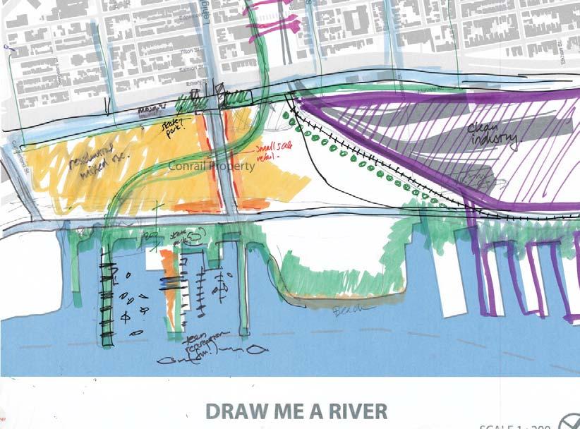
44 ACCESS: DYOTT STREET The circulation plan proposes to create a continuous North BeachStreet. Currently, there is a gap in Beach Street between Dyott Street and Schirra Drive. This connection will later be used for the creation of Delaware Boulevard, and is vital to creating a connected grid of streets to distribute traffic and create a pedestrian-accessible streetscape. Left: Concept sketch from Draw Me a River, envisioning substantial green space at the river s edge, mixed uses along Beach Street, green boulevards on Cumberland and York Streets, and a gateway at Richmond and Cumberland Street. Top right: An inviting, active open space overlooking the water. Bottom right: Current view of Dyott Street, swathed in asphalt and severed from the surrounding neighborhood by I GATEWAY CONCEPTS


45 Ownership information and land acreage estimates for parcels critical to the establishment of a stormwater management park at Dyott Street. Aerial view indicating proposed extension of Beach Street, which would eventually become part of the extended Delaware Boulevard. GATEWAY CONCEPTS 43

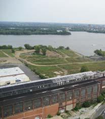
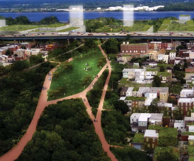
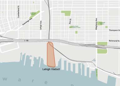
46 ACCESS: LEHIGH VIADUCT The Lehigh Viaduct stands above the rooftops adjacent to Lehigh Avenue, a wide corridor currently off-limits to the public. Once the site of dozens of railroad tracks, most of the corridor is now overgrown, and only a few sets of rails remain in use. The Viaduct offers a tremendous opportunity to establish a major regional open-space connector with an extensive green network enhanced by adjoining historic streams and creeks. The community vision for the Lehigh Viaduct is to create a major park with significant environmental enhancements that will absorb and filter stormwater runoff and help to mitigate air pollution. The realigned Delaware Boulevard and the continuous riverfront greenway will link the Viaduct and surrounding neighborhoods to other areas along the riverfront. New development could extend the city to the river s edge, meeting the continuous riverfront park. This page: An aerial view of the vast natural resources encompassing the Lehigh Viaduct, currently off-limits to the public. Opposite page: Left: Draw Me a River participants envisioned a trail spanning the Lehigh Viaduct and extending to a continuous park along the riverfront. The neighborhood grid also extends to the waterfront with a vibrant mix of uses along Lehigh Avenue. Top center: The overgrown Lehigh Viaduct is in sight but off-limits to neighborhood residents. Top right: Restored natural habitat protects endemic species, manages stormwater runoff, and offers opportunities for passive recreation as well as riverfront access. Bottom center: Once heavily traversed by rail, the viaduct is now a wide swath of open space with only a pair of operable rails. 44 GATEWAY CONCEPTS

47 GATEWAY CONCEPTS 45


.")


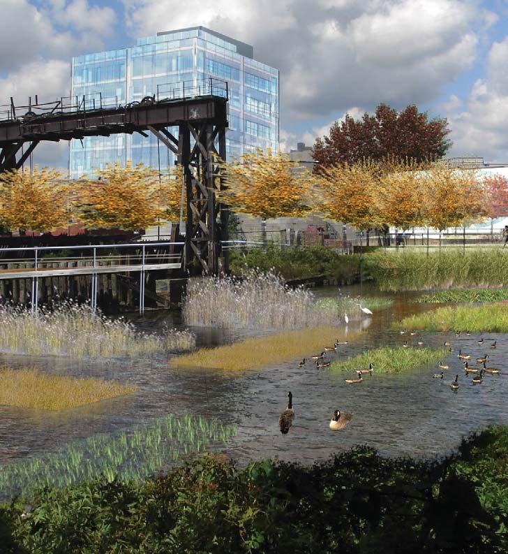
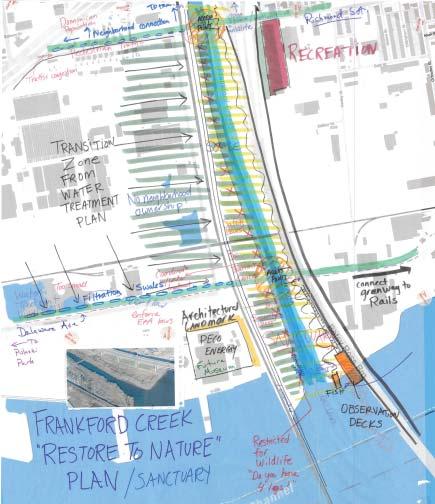
48 ACCESS: FRANKFORD CREEK Frankford Creek runs in a man-made canal between the approaches to the Delair Railroad Bridge and the Betsy Ross Bridge. The creek is extremely difficult to access, compounded by security restrictions that took effect after 9/11. The vision for the creek is to upgrade the natural habitat and green corridor while providing access for passive recreation and a bicycle trail that will eventually connect to Tacony Creek Park. The creek will tie into the expanded Delaware Boulevard and preserve valuable habitat along the river. This page: Top left: Riverfront boardwalk, Brooklyn Bridge Park. Top right: Viewing benches at Schuylkill River Park, Philadelphia (WRT). Bottom right: Lawn at Commodore Barry Bridge Park, Chester, PA. Bottom left: Currently the best view of Frankford Creek is through a chain-link fence. Opposite page: Left: Residents expressed their desire to see Frankford Creek restored to its natural state at the Draw Me a River workshop. They also envisioned fi ltrating swales along Delaware Avenue, a museum occupying the PECO building, and a greenway connection north of the Betsy Ross Bridge. Middle: The North Delaware Plan, completed by Field Operations, proposes continuous access and recreation fields along the northern bank of Frankford Creek. Far right: Rip-rap edge and lawn at Hudson River Park, New York City, NY 46 GATEWAY CONCEPTS

49 GATEWAY CONCEPTS 47


50 GATEWAY CONCEPTS: PARKS Penn Treaty Park Dyott Street Lehigh Viaduct Pulaski Park Frankford Creek Park 48 GATEWAY CONCEPTS

51 PARK GATEWAYS GATEWAY CONCEPTS 49

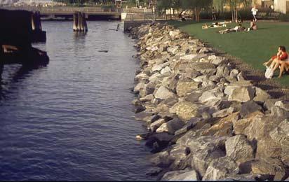
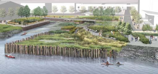
52 PARKS: PENN TREATY PARK Improvements to Penn Treaty Park will assist this existing green space retain its value as an important community asset and gathering space. The proposed improvements will provide enhanced stormwater management and complement the proposed boulevard running along Delaware Avenue. Recommended enhancements include the creation of a naturalized edge and a connection to the proposed greenway. The restored riparian edge would stabilize the river/park edge, create a sustainable habitat for endemic species of plants and animals, and preserve the unimpeded view to the Ben Franklin Bridge and the city skyline. Other recommended changes include redistribution of certain park features to better encourage views into and across the park and enhanced use of the park. Those recommendations include flattening of the earthen mound along Delaware Avenue; relocation of the children s play zone from a flood-prone area to a more prominent location; and relocation of park parking to the southern perimeter. Negotiation with PECO for use of their property immediately adjacent to the north face of the park for overflow parking is also recommended. Proposed additional features for the park include a vending kiosk at the edge of the southern parking court and a solarpowered environmental education exhibit near the wetland area. The proposed greenway and new paths leading to the park will attract residents from Fishtown and the proposed riverfront developments to an enhanced Penn Treaty Park. Because of the park s historic significance, its key riverfront location and its proximity to both existing, underserved neighborhoods and to proposed high-rise development, it has the potential to become a signature park for the city. As a signature park, it would serve its immediate neighbors and act as a destination for others from beyond the neighborhood. Opposite page: Left: Enhancements proposed for Penn Treaty Park include the integration of educational elements for school children such as a wetland along the river s edge, rain gardens, and solar energy technologies. Right: At an expanded Penn Treaty Park, creating a wetland at the river s edge would offer the opportunity to provide an outdoor educational center for school children. Moving and expanding the playground to higher ground at the southern edge of the park would distribute activities around the edge of the park. A comprehensive landscape plan that extends over Beach Street to I-95 will link the park to the neighborhood. 50 GATEWAY CONCEPTS


53 Great Lawn Tree Canopy Restored Riparian Edge Plaza Rain Gardens; Educational Component Relocated Playground Art installation Street Parking Cafe Paths Boardwalks Sculpture Water feature Environmental Education Exhibit GATEWAY CONCEPTS 51


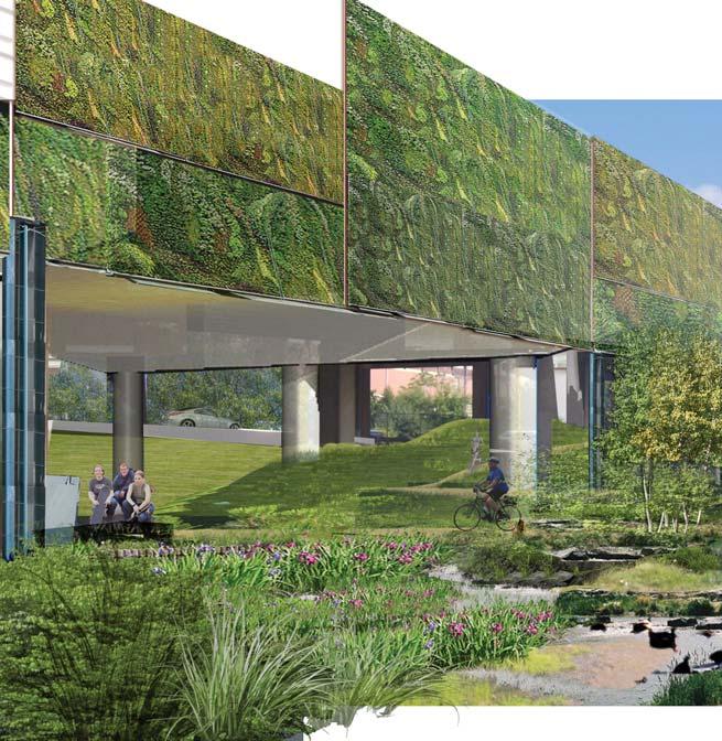
54 PARKS:DYOTT STREET / STORMWATER PARK AT GIRARD AVENUE INTERCHANGE The intersection of Allegheny and Girard Avenues is currently a tangled knot of highways, underpasses, and on and off ramps, severing the neighborhood from the riverfront and creating an environment that is hostile to pedestrians. PennDOT was scheduled to begin the reconstruction of the Girard Avenue Interchange in January of The changes to the interchange present an opportunity for PennDOT to construct a park that will be accessible to the community and manage stormwater runoff. The vision for the park beneath Interstate 95 entails: Top right: The open space beneath I-95 offers an abundant opportunity to capture and treat runoff from the highway while creating pedestrianfriendly portals between the riverfront and surrounding neighborhoods. Bottom: The plan dramatically transforms a highly visible, physical impediment into a community amenity. Enhanced walkway along Aramingo Avenue to Dyott Street and to the river, including traffic management at Girard Avenue; A greenway between Penn Treaty Park and Richmond Street; The absorption of stormwater runoff from the highway; Planted sound walls to help mitigate noise and air pollution; Innovative lighting beneath the structure to create a safer, more traversable portal between the riverfront and the surrounding neighborhoods; Recreational sites and parking beneath the elevated structure. Park-like Open Space under Girard Interchange Stormwater Run-off Infiltration (8 acre-feet) Open Space under I-95 Conversion of Highway Embankment to Structure Highway On/Off Ramps (at-grade barriers) Local, At-Grade Road (under interchange) Proposed At-Grade Local Road Reconfiguration Pedestrian Circulation Concept Significant Pedestrian Portals under I GATEWAY CONCEPTS

55 Stormwater Park at Girard Interchange Working with PennDOT during the Central Delaware planning process, WRT developed conceptual plans for this NKCDC gateway. Continuing the dialogue with PennDOT is critical for the successful implementation of this gateway concept. GATEWAY CONCEPTS 53


56 PARKS: LEHIGH VIADUCT,POTENTIAL STATE PARK The Lehigh Viaduct offers a large open space that could serve as both a destination and a green corridor. The community vision for the viaduct is a park with nature trails, restored habitat, and space for active recreation. Access to the neighborhood would be convenient and pedestrian-friendly. The greenway connection would also connect the East Coast Greenway and the riverfront to other areas of the city, potentially reaching all the way to the Schuylkill River. The Viaduct is of such potential significance, environmentally, culturally, and in terms of providing much needed access to recreation for underserved neighborhoods, that it is a prime candidate for a new state park. Middle: Paths and open space at Coolidge Park in Chattanooga, TN Opposite page: The Civic Vision for the Central Delaware proposes more intensive use of the Conrail site with a restored natural edge and nature trails forming a continuous riverfront park. The Lehigh Viaduct would extend the park from the river through the city, creating a regional green corridor. 54 GATEWAY CONCEPTS

57 GATEWAY CONCEPTS 55


58 PARKS: PULASKI PARK Pulaski Park is a sliver of green space in an otherwise concretecovered industrial corridor. It is a treasured community amenity, but not without design and maintenance challenges. The community vision for Pulaski Park entails expansion over time. Currently, the Park is adjacent to property controlled by the state and occupied through lease agreements. The vision for Pulaski Park includes the creation of a naturalized edge along the river, providing a public landscape. The existing gantries could be featured, representing Port Richmond s identity as a former industrial powerhouse and as focal points for an enlarged park. Environmental enhancement concepts demonstrate the potential for the restoration of ecological function in the river. One concept shown is a grid of rafts with experimental plantings that could provide habitat and create a rich aquatic ecosystem for fish and nesting birds. The restored barge pier could become an attraction for fishing and a visual platform that offers open views of the river, the adjacent pier housing and its park, New Jersey, and the area abutting Pulaski Park. This page: Top right: A recent aerial view of Pulaski Park barely shows the sliver of green along the edge of the heavy industrial area. Bottom right: The vision for Pulaski Park significantly expands the park s acreage and public offerings with playing fields, community festival space, environmental enhancements, and improved riverfront access. Opposite page: Creating a tidal wetland by planting vegetation along the north edge of the Conrail site would enhance habitat, fishing opportunities, and other river recreation. The piers also offer opportunities for adaptive reuse as fi shing piers. Pulaski Park is also envisioned as a large green space that will tie into the extended green boulevard running along Delaware Avenue and away from the river along Allegheny Avenue, extending the green corridor well into the neighborhood of Port Richmond. 56 GATEWAY CONCEPTS

59 GATEWAY CONCEPTS 57


60 PARKS: FRANKFORD CREEK PARK Frankford Creek is envisioned as a linear riparian park connecting Tacony Creek Park to the Delaware River. The vision for this corridor is of a restored environment, left partly in a natural state but with public access. DRPA maintains the land near the Betsy Ross Bridge as a lawn, but this area is fenced. This land could be reclaimed as public space. A bicycle trail would run parallel to the creek connecting to Tacony Creek Park. 58 GATEWAY CONCEPTS

.")
61 Waterfront recreation trails at Emscher Park, a brownfi eld redevelopment in the Ruhr Valley, Germany (above), and Schuylkill River Park in Philadelphia (right). GATEWAY CONCEPTS 59


62 GATEWAY CONCEPTS: STREETSCAPES Frankford Avenue Columbia Avenue Cumberland Street Lehigh Avenue Allegheny Avenue Delaware Boulevard 60 GATEWAY CONCEPTS

63 STREETSCAPE GATEWAYS The six gateway streetscapes were identifi ed with the Riverfront Task Force members to ensure better connection along major streets to the west and north, connecting to the proposed trail north of the Betsy Ross Bridge. GATEWAY CONCEPTS 61

64 STREETSCAPES: FRANKFORD AVENUE A major thoroughfare in the community, Frankford Avenue presents an opportunity to create a distinctive green corridor that extends to the riverfront. The existing cross section includes a travel lane in each direction and a parking lane on each side of the street. The vision for this street is a green street and bicycle corridor. The cross section of the corridor would be changed. Parking on the south side of the street would be removed to create a bicycle lane in each direction, creating a high-quality bicycle link to the new riverfront trail. The sidewalk area would be widened into the remaining parking lane at intersections to create rain garden areas that would be used to filter stormwater and also serve as a place to locate bicycle racks, landscape, and artwork. The parking lane would be paved with pervious pavement to reduce stormwater runoff. Street trees would be installed on both sides of the streets and overhead utilities would be relocated or placed underground. Where minor cross streets intersect with Frankford Avenue, the sidewalk will be extended at an even level across the crossing street to create a continuous pedestrian realm. Cars would drive over a gentle rise to enter or exit the crossing streets, also serving to calm traffic in the neighborhood. At the intersection with Girard Avenue, new medians and sidewalk widenings would create a major public node at Girard Avenue and help create a green identity for the surrounding neighborhood. The Commerce Department has received Transportation Enhancement funding for streetscape improvements on Girard Avenue that includes this intersection. New pedestrian lighting would be installed on the corridor to create a safer and more attractive streetscape. 62 GATEWAY CONCEPTS


65 Access to river Frankford Avenue East of Girard Avenue This photo simulation illustrates the streetscape concepts for Frankford Avenue, which include bike lanes, rain gardens, reconstruction of I-95 as a viaduct, and parking and recreational uses under I-95. This model for I-95 emulates the skating rink and public parking in South Philadelphia. Proposed Streetscape Plan This plan illustrates potential locations of bump-outs, rain gardens, parks and recreation along Frankford Avenue from Palmer Square to the river. GATEWAY CONCEPTS 63


66 EXISTING FRANKFORD AVENUE STREET SECTION 64 GATEWAY CONCEPTS

67 PROPOSED FRANKFORD AVENUE STREET SECTION EAST OF GIRARD AVENUE The section of Frankford Avenue to the east of Girard Avenue can accommodate bike lanes and rain gardens that will move parking under the I-95 viaduct. The community should advocate for a viaduct reconstruction to facilitate this streetscape recommendation. GATEWAY CONCEPTS 65


68 PROPOSED FRANKFORD AVENUE STREET SECTION WEST OF GIRARD AVENUE For this stretch of Frankford Avenue, the plan recommends corner bump-outs and rain gardens only because this area needs to maintain its on-street parking resources. 66 GATEWAY CONCEPTS

69 Existing Typical Side Street Section Proposed Intersection Option One Proposed Intersection Option Two The plan recommends pedestrian crosswalk enhancements at the smaller side streets to improve pedestrian connectivity. This approach is typical and applicable to many of the streetscapes highlighted in this plan. GATEWAY CONCEPTS 67


70 EXISTING GIRARD AVENUE AT FRANKFORD AVENUE STREET SECTION 68 GATEWAY CONCEPTS

71 PROPOSED GIRARD AVENUE AT FRANKFORD AVENUE STREET SECTION In order to improve pedestrian connections along Frankford Avenue to the river, this plan recommends bump-outs and lane realignments to create shorter pedestrian crossing distances and areas for sidewalk retail services, such as cafes. GATEWAY CONCEPTS 69


72 STREETSCAPES: COLUMBIA AVENUE Columbia Avenue connects Palmer Square, Hetzel Playground, and Penn Treaty Park. It is a pedestrian-scaled, primarily residential street, with a 50-foot right of way. The vision for Columbia Avenue is a green street that links important open spaces in New Kensington. Street trees would be planted throughout the corridor and lighting would be upgraded. Rain gardens would be installed at intersections to filter stormwater. The parking lanes would be repaved with pervious paving to further reduce stormwater runoff. Where minor cross streets intersect with Columbia Avenue, the sidewalk will be extended at an even level across the cross street to create a continuous pedestrian realm. Cars would drive over a gentle rise to enter or exit the crossing streets, also serving to calm traffic in the neighborhood. Right: The area where Columbia Avenue passes under I-95 and connects to Delaware Avenue is hostile to pedestrians. When the reconstruction of I-95 takes place, the intersection is expected to improve for both cars and pedestrians. 70 GATEWAY CONCEPTS


73 Existing Plan Currently, the Girard Avenue Interchange of I-95 begins with ramping at Columbia Avenue, which will be consolidated to the north above Aramingo Avenue. Proposed Plan Based on PennDOT s reconstruction plans, Delaware Avenue is extended at grade, parallel to I-95, creating better pedestrian connections from Columbia Avenue to the north. This plan recommends additional enhancements to Columbia Avenue, which include parking under a viaduct version of I-95, pervious aurface parking lanes, bump-outs with rain gardens and parks. GATEWAY CONCEPTS 71


74 EXISTING COLUMBIA AVENUE STREET SECTION In addition to the streetscape improvements that will green up Columbia Avenue, the plan recommends pedestrian crosswalk enhancements at the smaller side streets to improve pedestrian connectivity. 72 GATEWAY CONCEPTS

75 PROPOSED COLUMBIA AVENUE STREET SECTION GATEWAY CONCEPTS 73


76 EXISTING GIRARD AVENUE AT COLUMBIA AVENUE STREET SECTION GATEWAY CONCEPTS

77 PROPOSED GIRARD AVENUE AT COLUMBIA AVENUE STREET SECTION Like the intersection at Frankford Avenue, this plan recommends enhancements to this intersection of Columbia and Girard Avenues. The reduction in pedestrian crossing distances provides opportunities for sidewalk retail services, such as cafes. GATEWAY CONCEPTS 75


78 STREETSCAPES: CUMBERLAND STREET Cumberland Street is an arterial street that connects to Aramingo Avenue, Delaware Avenue, and I-95. This street could be upgraded as part of the I-95 reconstruction project. The vision for this corridor is to create a green boulevard that connects Aramingo Avenue to the riverfront. New pedestrian connections would be established to Delaware Avenue and the riverfront. Intersections would be designed with safer pedestrian and bicycle crossings. This plan advocates for best practices in the design of viaduct structures and the uses that can be accommodated under them. At Cumberland Street, the height of the I-95 viaduct allows for a park landscape beneath the structure that includes stormwater infiltration and dramatic nighttime lighting of the proposed structure. Far Right: Cumberland Street borders residential and auto-oriented retail uses, but does not present a cohesive pedestrian environment. 76 GATEWAY CONCEPTS


 Right: A stormwater infi ltration planter on SW 12th Avenue on the Portland State")
79 Far left: The I-5 Colonnade in Seattle, WA, is a 7.5-acre city park under Interstate 5, with a dog park, art installations, and a mountain biking park. Middle: Overpass lighting creates a dramatic effect in Alingsas, Sweden. Light in Alingsas is an annual event where lighting designers from all over the world are invited to creatively light structures. (Flickr.com; user: iapia) Right: A stormwater infi ltration planter on SW 12th Avenue on the Portland State University campus is part of a series of landscaped stormwater planters designed to capture and infi ltrate about 8,000 square feet of street runoff. (portlandonline.com) GATEWAY CONCEPTS 77


80 EXISTING CUMBERLAND STREET SECTION 78 GATEWAY CONCEPTS

81 PROPOSED CUMBERLAND STREET SECTION In addition to the streetscape improvements that will green up the street, Cumberland Street provides pedestrian access to the Girard Avenue trolley and buses that stop under the I-95 viaduct. GATEWAY CONCEPTS 79

82 STREETSCAPES: LEHIGH AVENUE Lehigh Avenue is a wide street that leads to the Conrail property on the Delaware River. The generous 120-foot right of way offers ample opportunity to create a green corridor with enhanced bicycle facilities. This corridor was studied as part of the City s GreenPlan Philadelphia, which addresses the open space system of the city. GreenPlan Philadelphia includes simulations and concepts for Lehigh that exemplify the green street approach. The vision for this corridor is to create a linear park-like street that reduces stormwater runoff and provides good bicycle access. The street cross section currently has much unused area. The proposed concept includes physically separated bike lanes, retention of existing back-in diagonal parking, a green stormwater-filtration median, and rain gardens at intersections. Street trees would be installed throughout the corridor and lighting would be upgraded. Lehigh would be extended to the river under the circulation concept proposed in this and other riverfront plans. This page: In coordination with GreenPlan Philadelphia, the plan proposes a greening of Lehigh Avenue. Opposite page, clockwise, from left: Lehigh Avenue parallels the Lehigh rail viaduct and connects Aramingo Square to the riverfront property. While the Lehigh rail viaduct is abundant with trees, Lehigh Avenue is a wide swath of impervious pavement with few trees. Diagonal parking on the street coexists with bike lanes and two travel lanes. The I-95 viaduct at Lehigh Avenue provides a great opportunity for uses such as a farmer s market, like this one in Portland, OR. Lehigh Avenue s connection to the river is blocked by the change in grade at the Conrail site s terminus. The center turn lane provides an opportunity for a landscaped, stormwater-fi ltering median. 80 GATEWAY CONCEPTS

83 GATEWAY CONCEPTS 81

84 EXISTING LEHIGH AVENUE STREET SECTION 82 GATEWAY CONCEPTS

85 PROPOSED LEHIGH AVENUE STREET SECTION Lehigh Avenue provides ample dimension for parking, bicycles and the transformation of the street into a tree-lined boulevard. GATEWAY CONCEPTS 83


86 STREETSCAPES: ALLEGHENY AVENUE Allegheny Avenue is an important arterial street that connects Campbell Park, Monkiewicz Playground, and Pulaski Park, has access to I-95, and provides an important route to the Tioga Marine Terminal and associated industrial areas. It also hosts a major flow of traffic to and from the Interstate. The 120-foot right of way offers many opportunities for an enhanced streetscape. Cairone & Kaupp Inc., in collaboration with David S. Traub Associates, have developed a greenway concept for Allegheny Avenue entitled Returning the Port to Port Richmond that emphasizes the community landmarks, such as illuminated church spires, and creates a green corridor linking the parks. The vision for Allegheny Avenue is a beautiful mixed-use corridor connecting the parks of the avenue to each other and to the river. The church steeples and architectural landmarks will receive architectural lighting. The streetscape will be enhanced with new street trees, pedestrian lighting, improved paving, sidewalk widening at intersections, façade restoration, rain gardens, and possibly a landscaped median. 84 GATEWAY CONCEPTS

87 As part of the Civic Vision for the Central Delaware, Allegheny Avenue is proposed to connect to an extension of Delaware Boulevard along the river. This view shows Allegheny Avenue as a boulevard with a median and a park edge along the Tioga Marine Terminal to the north. GATEWAY CONCEPTS 85


88 EXISTING ALLEGHENY AVENUE STREET SECTION EAST OF I GATEWAY CONCEPTS

89 PROPOSED ALLEGHENY AVENUE STREET SECTION EAST OF I-95 The proposed extension of Delaware Boulevard is envisioned as a wide, tree-lined boulevard with a center median, stormwater fi ltration gardens, commuter bike lanes, and a 12-foot-wide recreational path. GATEWAY CONCEPTS 87


90 EXISTING ALLEGHENY AVENUE STREET SECTION WEST OF I GATEWAY CONCEPTS

91 PROPOSED ALLEGHENY AVENUE STREET SECTION WEST OF I-95 Building on grass-roots efforts by Cairone & Kaupp Inc. and David S. Traub Associates to enhance the streetscape along Allegheny Avenue, this plan recommends a comprehensive greening strategy. By integrating stormwater management and landscape design, the plan can serve as a model green street for the city. GATEWAY CONCEPTS 89


92 STREETSCAPES: DELAWARE AVENUE BOULEVARD EXTENSION The Civic Vision for the Central Delaware proposes a riverfront boulevard between Tioga Marine Terminal and Oregon Avenue. This boulevard is an integral concept to developing the riverfront as a mixed-use district. The vision for Delaware Avenue is a multi-modal boulevard with a light rail line, bike facilities, pedestrian amenities, and a treelined streetscape that incorporates best practices in stormwater management. The boulevard will be extended past Penn Treaty Park and the PECO power station along the alignment of North Beach Street, and then extending through the Conrail property to connect with Allegheny Avenue at a new open space and expanded Pulaski Park. A mix of recreational spaces along waterfront boulevards can support a variety of programs and landscapes, from running paths to soft lawns, and from urban plazas to riparian edges. The boulevard edge becomes the seam between riverfront park uses and the urban streetscape, as in Portland s South Waterfront (top left) and at Battery Park City in New York (right and bottom). (image at right: fl ickr.com; user: bethlet). 90 GATEWAY CONCEPTS

93 The proposed Delaware Avenue street section along the river at the Conrail site. GATEWAY CONCEPTS 91


94 EXISTING DELAWARE AVENUE STREET SECTION 92 GATEWAY CONCEPTS

95 PROPOSED DELAWARE AVENUE STREET SECTION Important to connecting to the North Delaware River is the safe integration of a multi-use trail between Allegheny Avenue and the Betsy Ross Bridge through Tioga Marine Terminal. The plan recommends the separation of truck traffi c from the trail and pedestrian enhancements. GATEWAY CONCEPTS 93
I-95 Girard Avenue Interchange Near Neighbors Meeting. Project Status
 I-95 Girard Avenue Interchange Project Status Construction is underway for Phase 1 and 2. Phase 3 construction will begin early 2014. Overall Project Area and Schedule GR0: Completed GR0: Completed in
CHAPTER 8 ISSUES, CONCERNS, CONSTRAINTS AND OPPORTUNITIES
 CHAPTER 8 ISSUES, CONCERNS, CONSTRAINTS AND OPPORTUNITIES Introduction This River Conservation Plan was developed during a time of tremendous activity and effort in planning the transformation of the Delaware
EXECUTIVE SUMMARY EXECUTIVE SUMMARY
 1 EXECUTIVE SUMMARY EXECUTIVE SUMMARY Penn s Landing is envisioned as a welcoming riverfront green space adjacent to a refurbished civic marina becoming the centerpiece for adjacent development. With a
Potential Green Infrastructure Strategies May 6, 2015 Workshop
 Potential Green Infrastructure Strategies May 6, 2015 Workshop Background The City of Cortland is developing the Tioughnioga Urban Headwaters Green Infrastructure Action Plan with funding from the National
PARKS AND OPEN SPACE PARKS AND OPEN SPACE
 Purpose General Findings Goals Early Action Create New Parks Connect the City to the Riverfront Invest in a Sustainable Riverfront PARKS AND OPEN SPACE 6 PARKS AND OPEN SPACE Port Richmond Riverfront Park
ROUND ONE PROJECTS. Capital Grants 18 DELAWARE VALLEY REGIONAL PLANNING COMMISSION
 ROUND ONE PROJECTS DVRPC awarded the first round Take Me to the River grants in 2008 (see Figure 5 for project locations). The 13 projects selected were chosen based on their ability to reconnect citizens
Transportation. Strategies for Action
 Transportation A major priority for the Overlake Neighborhood is to develop a multimodal transportation system. To achieve this system, a balance has to be found among travel, circulation and access needs;
The transportation system in a community is an
 7 TRANSPORTATION The transportation system in a community is an important factor contributing to the quality of life of the residents. Without a sound transportation system to bring both goods and patrons
10.0 Open Space and Public Realm
 10.0 Open Space and Public Realm 10.0 Open Space and Public Realm The Public Open Space System is comprised of: outdoor spaces available for public use that are either publicly owned (e.g., parks and
Queensborough Eastern Neighbourhood Node. Community Open House
 Queensborough Eastern Community Open House The Vision The Queensborough Eastern will become the heart of eastern Queensborough. Through a sensitive mix of viable commercial and residential areas, the neighbourhood
Project Status. Construction is underway for Phase 3. Overall Project Area and Schedule. Schedule of Current Construction Phases.
 I-95 Avenue Interchange Project Status Construction is underway for Phase 3. Overall Project Area and Schedule Phase 0: Completed 2010 Section GR0: Completed in Fallin 2010 Phase 2: Completed Section GR2:
Corridor Vision. 1Pursue Minnehaha-Hiawatha Community Works Project. Mission of Hennepin County Community Works Program
 1Pursue Minnehaha-Hiawatha Community Works Project Minnehaha-Hiawatha Community Works is a project within the Hennepin Community Works (HCW) program. The mission of the HCW program is to enhance how the
Delaware River Waterfront Corporation
 Delaware River Waterfront Corporation Delaware River Waterfront Corporation Created in January 2009 to replace Penn s Landing Corporation o Open, accountable, effective leadership o New Board of Directors
Gold Line Bus Rapid Transit Transit Oriented Development (BRTOD) Helmo Station Area Plan
 Helmo Station Area Plan") Appendix F Gold Line Bus Rapid Transit Transit Oriented Development (BRTOD) Helmo Station Area Plan Introduction and Purpose of the Plan The Gold Line Bus Rapid Transit facility is an eleven-mile dedicated
Appendix F Gold Line Bus Rapid Transit Transit Oriented Development (BRTOD) Helmo Station Area Plan Introduction and Purpose of the Plan The Gold Line Bus Rapid Transit facility is an eleven-mile dedicated
ALMONO. Hazelwood, City of Pittsburgh. A riverfront investment opportunity combining residential, office and light industrial uses A L M O N O S I T E
 Tecumseh St. ALMONO Hazelwood, City of Pittsburgh A riverfront investment opportunity combining residential, office and light industrial uses Downtown Pittsburgh Oakland South Side Flats Birmingham Bridge
Policies and Code Intent Sections Related to Town Center
 Policies and Code Intent Sections Related to Town Center The Town Center Vision is scattered throughout the Comprehensive Plan, development code and the 1994 Town Center Plan. What follows are sections
Town Center (part of the Comprehensive Plan)
") Town Center (part of the Comprehensive Plan) Mercer Island Town Center Looking North (2014) In 1994, a year-long process culminated in a set of design guidelines and code requirements for the Town Center
Town Center (part of the Comprehensive Plan) Mercer Island Town Center Looking North (2014) In 1994, a year-long process culminated in a set of design guidelines and code requirements for the Town Center
PLAN ELEMENTS WORKSHOP. April 5, 2016
 PLAN ELEMENTS WORKSHOP April 5, 2016 needs more housing. But there is no one-size fits-all solution. Every neighborhood has its own character. In some places, density is not only appropriate it is badly
SQUAMISH 2010 AND BEYOND COMMUNITY VISION
 Our plan has been imagined and created to be both pragmatic and visionary. At the core of the strategy is a consideration of the highway s role and its impact on the community. First and foremost in creating
The West Vaughan Employment Area Secondary Plan Policies
 Part 2: The West Vaughan Employment Area Secondary Plan Policies 2.1 General Policies It is the policy of Council: 2.1.1. That the West Vaughan Employment Area (the WVEA), identified on Schedule 1, will
VEHICULAR AND PEDESTRIAN CIRCULATION
 This perspective sketch communicates the intended character and quality of a proposed streetscape design. Locate benches near a major intersection where people tend to gather. Seating and lighting provide
RECREATION AND OPEN SPACE ELEMENT GOALS, OBJECTIVES, AND POLICIES
 RECREATION AND OPEN SPACE ELEMENT GOALS, OBJECTIVES, AND POLICIES Goal 7 To provide park facilities, recreation programs, and open space resources that are safe, adequate, and accessible to all City residents,
WEST LOOP DESIGN GUIDELINES CHECKLIST
 WEST LOOP DESIGN GUIDELINES CHECKLIST Section 1.0 General Strategies 1.1 DESIGN EXCELLENCE: ENCOURAGE HIGH QUALITY AND INNOVATIVE DESIGN OF NEW BUILDINGS WITHIN THE WEST LOOP WITHOUT BEING PRESCRIPTIVE
Urban Design Manual PLANNING AROUND RAPID TRANSIT STATIONS (PARTS) Introduction. Station Study Areas
 Introduction. Station Study Areas") 111111 PLANNING AROUND RAPID TRANSIT STATIONS (PARTS) Introduction The ION rapid transit system will link Waterloo, Kitchener and Cambridge through a central transit corridor (CTC). There are a number
111111 PLANNING AROUND RAPID TRANSIT STATIONS (PARTS) Introduction The ION rapid transit system will link Waterloo, Kitchener and Cambridge through a central transit corridor (CTC). There are a number
Planning Districts INTRODUCTION
 INTRODUCTION To facilitate detailed examination of development prospects for all areas of the community, Delano has been divided into 14 planning districts. The location of these planning districts is
EXISTING COMPREHENSIVE PLAN
 EXISTING COMPREHENSIVE PLAN Town Center Land Use Element: V. LAND USE POLICIES Town Center Mercer Island's business district vision as described in "Your Mercer Island Citizen-Designed Downtown" was an
CHAPTER 5: GUIDING PRINCIPLES
 CHAPTER 5: GUIDING PRINCIPLES The following 10 principles were developed based on public consultation, planning policy and the background analysis conducted during Phase 1. The Guiding Principles significantly
4.1.3 LAND USE CATEGORIES
 4.1.3 LAND USE CATEGORIES a. City Center District The City Center District incorporates the existing character and mix of uses in downtown Belmont to encourage redevelopment and new development in keeping
Northwest Rail Corridor and US 36 BRT Development Oriented Transit Analysis 4.4 STATION AREA FINDINGS
 4.4 STATION AREA FINDINGS Each station is different, and each one requires a separate set of recommendations based on the vision for the site. This section outlines an initial TOD strategy and recommendations
PUBLIC RIGHT-OF-WAY IN THIS CHAPTER PUBLIC REALM
 PUBLIC RIGHT-OF-WAY This section provides design guidelines for improvements in the public right-of-way. The public right-of-way refers to streets, sidewalks, non-vehicular thoroughfares, parks and greenways
38 Queen s University Campus Master Plan Part 1
 38 Queen s University Campus Master Plan Part 1 46 The Campus at the City Scale Chapter 4 The Campus at the City Scale 39 Queen s is an urban University centrally located in Kingston. Decisions made by
V. Vision and Guiding Principles
 V. Vision and Guiding Principles The Master Plan for the Powers Ferry Corridor seeks a foundation in the desires of the community. At times, various elements of the community offered opposing viewpoints,
Table of Contents. Elm Avenue Improvement Plan City of Waco, Texas. Introduction 1. Existing Context 1 Figure 1 2.
 Table of Contents Introduction 1 Existing Context 1 Figure 1 2 Plan Guidelines 3 Future Urban Form 4 The West-End 4 Main Street 6 The East-End 7 Figure 2 9 Public Improvement Recommendations 7 General
Clairtrell Area Context Plan
 Clairtrell Area Context Plan March 2005 Urban Development Services City Planning Contents 1. Introduction... 4 2. Development Structure... 6 2.1 Streets... 7 2.1.1 Sheppard Avenue and Bayview Avenue...
Issues Requiring Future Study
 Issues Requiring Future Study Transportation planning is an ongoing process that tends to identify new issues as it finds solutions for others. Some issues are so complex that a solution to one problem
Pedestrian and Bike Bridge LOGO
 6.2.2 Pedestrian and Bike Bridge The proposed pedestrian and bike crossing re-envisions the existing bridge at Pismo Creek on Cypress Street. The bridge is currently underutilized by vehicular through
Hockessin Community Redevelopment Plan
 Hockessin Community Redevelopment Plan 3.1 Introduction The Community Redevelopment Plan for the Village of Hockessin is the result of the people s vision for a distinct village center that serves as the
Olde Towne Vision Plan
 Olde Towne Vision Plan Introduction In 2016, the City of Bellevue will complete its move of City offices from Olde Towne Bellevue to its new municipal complex on Wall Street. The City intends to sell its
ROME WATERFRONT VILLAGE PROJECT NARRATIVE January 25, 2018
 January 25, 2018 The Rome Waterfront Village project is intended to foster the revitalization of the area between South James Street and Erie Boulevard north of the Erie Canal as well as improve public
Planning Board Briefing
 Planning Board Briefing Why Now? The Sector Plan Implementation Chapter States: Before Stage 1 begins, the following must occur: Approval of the Sectional Map Amendment. Approval of the Greater Lyttonsville
Camden SMART Initiative Stormwater Management and Resource Training
 Camden SMART Initiative Stormwater Management and Resource Training www.camdensmart.com Camden s Struggle with Stormwater 1 The City of Camden is served by a combined sewer system, which uses the same
Secrest Short Cut and Monroe Expressway Small Area Plan AUGUST 29, 2018
 Secrest Short Cut and Monroe Expressway Small Area Plan AUGUST 29, 2018 Background and Process Monroe Expressway will be open by the end of 2018 Union County and Indian Trail identified a need to revisit
The Benefits and Challenges Associated with Green Infrastructure Practices
 The Benefits and Challenges Associated with Green Infrastructure Practices Thomas M. Evans ASLA, LEED AP Regional Green Infrastructure Design Services Director OWEA Technical Conference, June 20, 2013
SAN RAFAEL GENERAL PLAN 2040 INTRODUCTION AND OVERVIEW
 SAN RAFAEL GENERAL PLAN 2040 INTRODUCTION AND OVERVIEW Steering Committee Presentation February 14, 2018 Purpose of General Plan Guide land use and development decisions Coordinate transportation, infrastructure,
North Fair Oaks Community Plan Summary and Information
 North Fair Oaks Community Plan Summary and Information WHAT IS THE NORTH FAIR OAKS COMMUNITY PLAN? The North Fair Oaks Community Plan is part of the San Mateo County General Plan, and establishes policies
{Best Practices. Summary of Tools, Strategies and Best Practices from 11 Michigan Case Study Communities
 Case Studies Michigan Coastal Community Working Waterfronts { Summary of Tools, Strategies and from 11 Michigan Case Study Communities Table of Contents Zoning...2 Community and Stakeholder Collaboration
Preliminary Plan Framework: Vision and Goals
 Preliminary Plan Framework: Vision and Goals Draft: May 2015 Introduction Since the Town of Milliken s comprehensive plan was last updated in 2010, the community was heavily impacted by the 2013 flood,
DRAFT. October Wheaton. Design Guidelines
 October 2011 DRAFT Wheaton Design Guidelines 2 Draft - Design Guidelines - Wheaton Sector Plan Contents 04 Section 1: Introduction 06 Section 2: Context 08 Section 3: Design Guidelines 09 Goal 1: Create
Civic Center District
 Civic Center District The Civic Center district is the civic and social heart of Warrenville, containing such public buildings as the City Hall, Warrenville Public Library, Police Station, Park District
5.1 Site Plan Guidelines
 5. Community Core Guidelines Development of the Community Core will take place by plan of subdivision and site plan approval. It will occur in a phased manner that will reflect the timing of residential
PORT OF VANCOUVER WATERFRONT DEVELOPMENT. Concept Development Plan City Center Redevelopment Authority April 20, 2017
 PORT OF VANCOUVER WATERFRONT DEVELOPMENT Concept Development Plan City Center Redevelopment Authority April 20, 2017 Port History PORT ESTABLISHED 1912 TERMINAL 1 ACQUIRED 1925 GWM SIGNS LEASE 1935 HARBOR
Workshop 3. City of Burlington Waterfront Hotel Planning Study. September 14, The Planning Partnership
 Workshop 3 City of Burlington Waterfront Hotel Planning Study September 14, 2017 The Planning Partnership The Waterfront Hotel Planning Study 01 The Brant & Lakeshore Planning Study will establish a Strategic
PUBLIC REALM DESIGN PLAN APRIL, 2012
 PUBLIC REALM DESIGN PLAN APRIL, 2012 Introduction NoMa is growing quickly. Fueled by transit accessibility, proximity to both Downtown and Capitol Hill and streamlined entitlements, the neighborhood has
Midtown Greenway Land Use and Development Plan Executive Summary
 Midtown Greenway Land Use and Development Plan Executive Summary Introduction The Midtown Greenway Land Use and Development Plan sets policy direction for land use and development in the Midtown Greenway
Description of Preferred Alternative
 Chapter 2 Description of Preferred Alternative 2.1 Introduction This chapter of the programmatic Sammamish Town Center Sub-area Plan Final EIS provides a more detailed description of the Preferred Alternative
QUEEN-RIVER SECONDARY PLAN
 34 QUEEN-RIVER SECONDARY PLAN 34. QUEEN RIVER SECONDARY PLAN 1. INTRODUCTION The Queen-River area is approximately 6.4 hectares and is located at the eastern edge of the Downtown as shown on Map 34-1.
COMMUNITY DESIGN. GOAL: Create livable and attractive communities. Intent
 COMMUNITY DESIGN Intent An attractive, well-designed County will attract quality development, instill civic pride, improve the visual character of the community, and create a strong, positive image for
The Vision. Photo provided by The Minervini Group. 46 Vision, Objectives & Strategies
 Vision, Objectives & Strategies The is the public framework and guide for future development of the Grand Traverse Commons. The establishes public polices for infrastructure, the preservation of natural
Port Lavaca Future Land Use
 Port Lavaca Future Land Use Introduction The City of Port Lavaca is beginning to see sustained growth, after many years of relative stable population. New single family homes, apartments, and businesses
The Five Components of the McLoughlin Area Plan
 The Five Components of the McLoughlin Area Plan This documents contains the complete language of the five components of the McLoughlin Area Plan: The Vision Statement The Values The Guiding Principles
hermitage town center
 hermitage town center A Community Vision prepared by Strada for The City of Hermitage and The Mercer County Regional Planning Commission January 2007 table of contents introduction 3 design principles
3 Vision and Goals. Vision and Goals. Blueprint for Bloomsburg. Vision. Town of Bloomsburg Comprehensive Plan,
 Vision and Goals 3 Vision and Goals Citizens of the Town of Bloomsburg clearly value their natural and cultural heritage, the walkable, mixed use pattern of downtown, the access to education, and the community
The University District envisions, in its neighborhood
 Envisioning the University District Link Light Rail in Seattle s neighborhoods CIY OF SEALE CONCEP-LEVEL SAION AREA PLANNING RECOMMENDAION RESOLUION # 30165 EXHIBI L Vision 08.2000 he University District
Town Center. Block 5 Existing multifamily residential units are expected to remain.
 Area Guidelines Germantown s districts should be developed as distinct communities with unique features that are supported through the guidelines. The guidelines not only help distinguish these districts
3. VISION AND GOALS. Vision Statement. Goals, Objectives and Policies
 Vision Statement Queen Creek s interconnected network of parks, trails, open spaces and recreation opportunities provide safe and diverse activities and programs that sustain its unique, small town, equestrian
URBAN DESIGN BRIEF URBAN DESIGN BRIEF 721 FRANKLIN BLVD, CAMBRIDGE August 2018
 URBAN DESIGN BRIEF URBAN DESIGN BRIEF 721 FRANKLIN BLVD, CAMBRIDGE August 2018 DESIGN BRIEF CONTENTS PART A 1.0 INTRODUCTION 2.0 DESCRIPTION & ANALYSIS OF SITE CONTEXT 3.0 DESIGN CONSTRAINTS AND OPPORTUNITIES
DRAFT FOR PUBLIC REVIEW. Game Plan for a Healthy City
 DRAFT FOR PUBLIC REVIEW 2018 Game Plan for a Healthy City 2 Denveright. Parks & Recreation Game Plan Draft for Public Review Draft for Public Review Executive Summary Game Plan Overview Executive Summary
McCowan Precinct Plan Study Background & Deliverables
 1 DRAFT & WITHOUT PREJUDICE McCowan Precinct Plan Study Background & Deliverables In September, 2011, City Planning (Scarborough District) began a study of an area within the Scarborough Centre, identified
Vacant Land Management and Reclamation in Philadelphia
 Vacant Land Management and Reclamation in Philadelphia J. Blaine Bonham, Jr. New Partners for Smart Growth Conference Building Safe, Healthy, and Livable Communities Washington D.C. February 7 9, 2008
1.0 Purpose of a Secondary Plan for the Masonville Transit Village
 Report to Planning and Environment Committee To: Chair and Members Planning & Environment Committee From: John M. Fleming Managing Director, Planning and City Planner Subject: Masonville Transit Village
S A C R A M E N T O C O U N T Y JACKSON HIGHWAY & GRANT LINE EAST VISIONING STUDY
 JACKSON HIGHWAY & GRANT LINE EAST S A C R A M E N T O C O U N T Y P L A N N I N G D E P A R T M E N T SUMMARY AND WORKBOOK November 19, 2008 History of the Visioning Study Sacramento County has two growth
A larger version of this map is located on the last page of this PDF.
 MAP Committee Input McLoughlin Area Draft Vision Map A larger version of this map is located on the last page of this PDF. 1. The map above is intended to portray a vision for the McLoughlin area. It highlights
ANCHOR TO ANCHOR. Rescale the street to create an iconic boulevard.
 ANCHOR TO ANCHOR Rescale the street to create an iconic boulevard. UR NE ER UV GO NE LA OBJECTIVES 1. Maintain appropriate traffic flow and prioritize commercial curb access 2. Mark gateways at the street
Section 4 BUILDING THE MASTER PLAN
 The Master Plan 33 Section 4 BUILDING THE MASTER PLAN Figure 4:1. A collaborative effort characterized the two design workshops sponsored by DISC to create hypothetical Master Plans for the Towers Property
Executive Summary. NY 7 / NY 2 Corridor
 Executive Summary NY 7 / NY 2 Corridor Transportation and Land Use Study December 2005 Prepared for: Town of Colonie Capital District Transportation Committee Prepared by: Introduction: Land use decisions
The open space system should provide connective elements, relate to natural resources, and enhance the suburban character of the landscape..
 The open space system should provide connective elements, relate to natural resources, and enhance the suburban character of the landscape.. Mixed-use and infill development should maintain or enhance
Complete Neighbourhood Guidelines Review Tool
 Complete Neighbourhood Guidelines Review Tool Prepared By: City of Regina Planning Department October 2014 Page 1 of 14 Community Development Review Checklist for Secondary Plans and Concept Plans The
TOWN COUNCIL / PLANNING COMMISSION
 Workshop #3 TOWN COUNCIL / PLANNING COMMISSION January 20, 2011 Consultant Team In Attendance Tonight BMS Design Group Nevada City and San Francisco Michael Smiley, AICP, ASLA Partner-in-Charge Nancy L.
Small Area Plan. South Gateway
 Small Area Plan Adopted May 12, 2008 South Gateway Purpose. The South Gateway Small Area Plan defines the City s expectations for the future of the southern entrance to the City at Interstate 85 and Highway
Highland Village Green Design Guidelines
 Highland Village Green Design Guidelines Publishing Information Title Highland Village Green Design Guidelins Author The City of Calgary Status DRAFT - Proposed document subject to changes Additional Copies
Courthouse Square Planning & Urban Design Study. Courthouse Square Working Group #13 October 15, 2014
 Courthouse Square Planning & Urban Design Study Courthouse Square Working Group #13 October 15, 2014 1 Courthouse Square Process Working Group Community Courthouse Square Advisory Groups & Civic Associations
Preface. Erie. Scranton. Allentown. Pittsburgh. Harrisburg. Philadelphia
 The Southern Alleghenies Region The Southern Alleghenies Region spans the Laurel Highlands and Allegheny Front in the west across the Appalachians to the east. It is comprised of Blair, Bedford, Cambria,
REGIONAL ACTIVITY CENTER
 DRAFT REGIONAL ACTIVITY CENTER 70 EAST BENCH MASTER PLAN DRAFT 06 Introduction The East Bench Regional Activity center is comprised of large educational, research, medical, and employment centers. These
DENVER DESIGN DISTRICT GDP
 DENVER DESIGN DISTRICT GDP Urban Design Standards and Guidelines November 17, 2008 Amended February 3, 2016 City and County of Denver CF Property Management, Inc. C/O Denver Design District - Starboard
DRAFT ROOSEVELT ROAD. District Recommendations. Figure 5.23 The Roosevelt Road Corridor
 CHAPTER 5 Figure 5.23 The Road Corridor Road will develop as a mixed-use corridor, emphasizing regional retail, west of the river and mixed-use development east of the river. KEY RECOMMENDATIONS 1. High
A. Background Summary of Existing Challenges and Potential Possibilities. 1. Summary of Existing Assets and Potential Opportunities
 A. Background 1 A Main Street Master Plan Study was performed and completed in October of 2007. The study was initiated to review current land uses and development patterns along Main Street, from Parrish
Existing Conditions. Planning and Design Principles
 penn s south bank enn s South Bank is located south of the Schuylkill River at the intersection of 4th Street and. This acre former heavy industrial site offers the opportunity to accommodate a variety
The Lower SaLuda Greenway
 The Lower SaLuda Greenway InITIaTIve a FLourIShInG Greenway. a hub For economic GrowTh. a ConneCTIon BeTween CoMMunITIeS. In April 2017 the Michael J. Mungo Foundation and Lexington County commissioned
Danvers High Street I-1 District Study
 Danvers High Street I-1 District Study Presentation of Final Recommendations Planning Board Presentation June 26 th, 2018 1 Introductions Metropolitan Area Planning Council Sam Cleaves AICP, Principal
Derry Green Corporate Business Park
 Town of Milton Derry Green Corporate Business Park Urban Design Guidelines BMI/Pace - June 2010 Draft 3 Prepared by: Brook McIlroy Planning + Urban Design / Pace Architects Suite 300-51 Camden Street Toronto,
10 Implementation. Implementation. Responsibility for Implementation. Blueprint for Bloomsburg. Town of Bloomsburg Comprehensive Plan 10-1
 Implementation 10 Implementation This chapter overviews how to use the comprehensive plan as a land use and programming tool for the Town of Bloomsburg and recommends annual review of the plan by the Town
BRADENTON RIVERWALK EXPANSION MASTER PLAN
 BRADENTON RIVERWALK EXPANSION MASTER PLAN INTRODUCTION & AGENDA Process Update Community Engagement Summary Center for Active Design (CfAD) Recommendations Context and Existing Conditions Master Plan Alternatives
Implementation Guide Comprehensive Plan City of Allen
 Implementation Guide 2030 Comprehensive Plan City of Allen DRAFT 2015 Implementation Guide Allen 2030 Comprehensive Plan INTRODUCTION The Comprehensive Plan serves as a guide for the growth and development
Throughout. square. (Crystal City Vision Plan 2050)
") 1: Terms related to the PSMP document 1 public space (see also public realm, civic space) An open space designated on the regulating plan, accessible to all, including Plazas, Mini Parks, and Neighborhoods
1: Terms related to the PSMP document 1 public space (see also public realm, civic space) An open space designated on the regulating plan, accessible to all, including Plazas, Mini Parks, and Neighborhoods
Asheville Design Center March 2010
 Community-Based Design Update Asheville Design Center March 2010 www.ashevilledesigncenter.org 1 introduction contents 1. Introduction 2. Background 3. ovember Design Charrette 4. January Work Session
ELMVALE ACRES SHOPPING CENTRE MASTER PLAN
 ELMVALE ACRES SHOPPING CENTRE MASTER PLAN Contents 1.0 INTRODUCTION... 2 2.0 LOCATION... 2 3.0 EXISTING CONTEXT... 2 4.0 VISION & GUIDING PRINCIPLES... 2 5.0 LAND USE AND BUILT FORM... 4 5.1 St. Laurent
ARISE: The Rock Renaissance Area Redevelopment & Implementation Strategy
 2014 Professional Awards 1 ARISE: The Rock Renaissance Area Redevelopment & Implementation Strategy Janesville, WI Completed December 2014 Analysis & Planning Purpose of Project 2 The purpose of the Rock
Toronto Complete Streets Guidelines
 Toronto Complete Streets Guidelines 108 110 7.1 Green Infrastructure Design Principles 112 7.2 Context-Sensitive Green Streets 114 7.3 Key Green Street Elements Green infrastructure refers to natural and
This Review Is Divided Into Two Phases:
 Semiahmoo Town Centre Review The purpose of this review: To review the Semiahmoo Town Centre Concept Plan, originally approved in 1993, to ensure that this centre will continue to serve the needs of South
The Illinois Department of Transportation and Lake County Division of Transportation. Route 173, including the Millburn Bypass
 The Illinois Department of Transportation and Lake County Division of Transportation welcome you to this Public Hearing for U.S. Route 45 from Illinois Route 132 to Illinois Route 173, including the Millburn